Articles
U-Pb (zircon) age for the Beaver Harbour Porphyry, New River belt, southern New Brunswick, Canada
ABSTRACT
The Beaver Harbour Porphyry is a high-level intermediate to felsic granitoid and locally tuffaceous unit with quartz and less abundant feldspar phenocrysts. It forms a fault-bound sliver along the southern margin of the New River belt in southern New Brunswick. A concordant TIMS U-Pb (zircon) age of 551 ± 1.2 Ma shows that the porphyry is of the same age as other high-level plutonic and volcanic units that form most of the New River belt. Chemical data show that these units likely formed in a volcanic-arc environment at an active continental margin. One sample from the porphyry has εNd(t) of -0.5, within the range of other samples from the New River belt and consistent with the interpretation that the belt is part of Ganderia, rather than Avalonia, which generally has more juvenile isotopic signatures.
RÉSUMÉ
Le porphyre de Beaver Harbour est un intermédiaire de haut niveau au granitoïde felsique et constitue une unité tu facée par endroits comportant des phénocristaux de quartz et, moins abondamment, de feldspath. Il forme un copeau du substratum rocheux limité par les failles le long de la marge Sud de la ceinture de New River, au sud du Nouveau Brunswick. L’âge de 551 ± 1,2 Ma concordant, obtenu par datation U-Pb sur zircon à l’aide de la spectrométrie de masse à thermoionisation, indique que le porphyre a le même âge que d’autres unités plutoniques et volcaniques de haut niveau qui composent la majeure partie de la ceinture de New River. Les données chimiques indiquent que ces unités se sont probablement formées dans un environnement d’arc volcanique, dans une marge continentale active. La valeur εNd(t) d’un échantillon du porphyre est de -0,5, ce qui correspond aux valeurs des autres échantillons de la ceinture de New River et à l’interprétation selon laquelle la ceinture fait partie du terrane de Ganderia, et non de l’Avalonia, qui présente généralement des signatures isotopiques plus jeunes.
[Traduit par la redaction]
INTRODUCTION
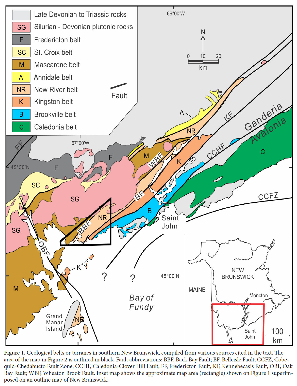
1 Southern New Brunswick consists of fault-bounded belts or terranes (Fig. 1) with contrasts in ages and rock types (e.g., Barr et al. 2014). Caledonia, the belt located most outboard from the Laurentian margin, is generally considered to be part of Avalonia, whereas the other belts have been interpreted to be part of Ganderia, although the original relationships among the belts are not entirely clear (e.g., Barr et al. 2014; Hibbard et al. 2006; Fyffe et al. 2009, 2011). The focus of the present study is in the New River belt, which is dominated by volcanic and plutonic rocks which have yielded diverse U-Pb (zircon) ages of ca. 630–620 Ma, 555 Ma, 540 Ma, and 515 Ma (Fig. 2). These rocks are separated from the mainly Silurian Mascarene belt to the northwest by the Back Bay Fault and from the mainly Silurian Kingston belt to the southeast by the Belleisle Fault (Figs. 1, 2).
 Display large image of Figure 1
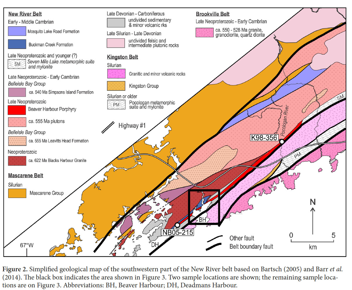 Display large image of Figure 2
2 One of the mapped components in the southwestern part of the New River belt is the Beaver Harbour Porphyry (Fig. 2), also known as the Woodland Cove Porphyry (Bartsch et al. 2007). This unit extends along the southeastern margin of the New River belt for a distance of about 25 km but outcrop is sporadic so it may not be a continuous unit. It has a maximum width of about 1 km in Pocologan River (Fig. 2). Contacts on both sides are faults, and along most of its length it is flanked by sedimentary units assigned to the Cambrian or Carboniferous (Fig. 2). The unit is best exposed along the shore of Woodland Cove in the Beaver Harbour area. Maps of its distribution differ in detail; however, the most detailed mapping in the area was done by Bartsch (2005), who interpreted the porphyry to be in faulted contact but closely associated with the Blacks Harbour Granite. Hence, Bartsch (2005) and Bartsch and Barr (2005) considered the age of the porphyry to be ca. 620 Ma based on the published age of 622 ± 2 Ma from the Blacks Harbour Granite (Barr et al. 2003).
3 The purpose of this paper to present a U-Pb (zircon) date for a sample collected from an outcrop of the Beaver Harbour Porphyry northeast of Woodland Cove (Fig. 3). The result reported here shows that the porphyry is 70 million years younger than the Blacks Harbour Granite and similar in age and chemical characteristics to the widespread ca. 555 Ma volcanic and plutonic units of the New River belt (Fig. 2). It should be noted that the age reported here, although unpublished, was used in recent papers and maps to assign a ca. 555 Ma age to the Beaver Harbour Porphyry (e.g., Fyffe et al. 2011; Barr et al. 2014).
GEOLOGICAL SETTING
4 The oldest episode of magmatism known in the New River belt is represented by the Lingley and Blacks Harbour granites, which yielded early Ediacaran U-Pb zircon ages of ca. 629–625 Ma and ca. 622 Ma, respectively (Currie and McNicoll 1999; Barr et al. 2003). No host rocks are known for these plutons, which are in faulted contact with adjacent units, including the Ragged Falls Granite and comagmatic volcanic rocks, including the Leavitts Head Formation, with U-Pb (zircon) dates between ca. 555 and ca. 553 Ma (Currie and Hunt 1991; McLeod et al. 2003). Although contacts are mainly faults, these Late Ediacaran units are inferred to be overlain by voluminous earliest Cambrian (ca. 539 to 541 Ma) mafic and felsic pyroclastic volcanic rocks and red and green micaceous sandstone and siltstone of the Belleisle Bay Group (Johnson and Barr 2004; Johnson et al. 2009). In the Long Reach area the Belleisle Bay Group is overlain by fossiliferous marine sedimentary rocks that have been correlated with the Saint John Group in the Caledonia belt based on lithological and biostratigraphic similarities (Yoon 1970; Tanoli and Pickerill 1988; Landing and Westrop 1996). In the southwestern part of the belt around Buckmans Creek, late Early Cambrian to middle Middle Cambrian fossiliferous marine sedimentary rocks are intercalated with mafic pyroclastic rocks (Helmstaedt 1968; Greenough et al. 1985; Landing et al. 2008).
 Display large image of Figure 3
5 In addition to the above units, the New River belt locally includes sedimentary and volcanic rocks of the Matthews Lake and Mosquito Lake Road formations. The age of the Matthews Lake Formation is bracketed by the presence of abundant ca. 539 Ma detrital zircons, likely derived from the Simpsons Island Formation of the Belleisle Bay Group (Fyffe et al. 2009), and a U-Pb age of 514 ± 2 Ma from a volcanic unit in the overlying Mosquito Lake Road Formation (Johnson and McLeod 1996). These volcanic rocks have been attributed to the early stages of Penobscot subduction, analogous to the ca. 513 Ma Tally Pond sequence in Newfoundland (van Staal 2007; Johnson et al. 2012).
6 The New River belt displays similarities to the Avalonian Caledonia belt (Fig. 2), in that both contain ca. 620 Ma and 555 Ma igneous suites, locally overlain by or in faulted contact with Cambrian sedimentary sequences (Currie and Hunt 1991; Currie and McNicoll 1999; Johnson and McLeod 1996; Johnson 2001; Barr et al. 2003, 2014; McLeod et al. 2003; Johnson and Barr 2004). However, Sm-Nd isotopic differences between the Neoproterozoic igneous units in New River and Caledonia terranes suggest that they have different crustal infrastructure (Samson et al. 2000; Barr et al. 2003), and the Cambrian successions differ in that those on the New River belt include volcanic rocks whereas those in Caledonia belt do not (e.g., Tanoli and Pickerill 1988). However, the significance of these differences is uncertain (e.g., Barr et al. 2014).
7 The New River belt is separated from the Caledonia belt by the Brookville and Kingston belts (Fig. 1). The Brookville belt is characterized by Neoproterozoic metasedimentary and ortho- and paragneissic rocks, as well as abundant ca. 550–528 Ma plutonic rocks and minor volcanic rocks (White and Barr 1996; White et al. 2002; Barr et al. 2014). The Kingston belt is a succession of Silurian (ca. 442–435 Ma) volcanic rocks and cogenetic high-level plutons interpreted to have formed in a continental margin volcanic arc (Barr et al. 2002). On the northwest, the New River belt is in faulted contact with Cambrian–Devonian volcanic and sedimentary sequences of the Mascarene and Annidale belts, and intruded by Silurian–Devonian plutons (Figs. 2, 3).
GEOLOGY OF THE BEAVER HARBOUR AREA
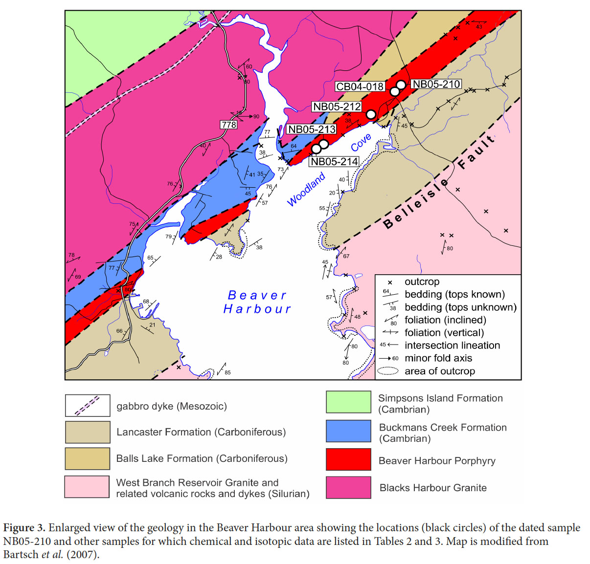
8 As mapped by Helmstaedt (1968) and Bartsch (2005), the Beaver Harbour Porphyry occurs as faulted slivers in the Blacks Harbour Granite in the Deadmans Harbour Beaver Harbour area, and also extends along the shoreline of Woodland Cove and along the southern margin of the belt as far as New River (Figs. 1–3). The bounding faults dip at moderate to steep angles to the northwest (Bartsch 2005). The contact between the Ragged Falls Granite and Beaver Harbour Porphyry is not exposed along Pocologan River, but is inferred to be a fault (Bartsch 2005; Bartsch et al. 2007). On the southeast, the porphyry unit is in inferred faulted contact with Silurian rocks of the Kingston belt in the Pocologan-New River area but farther to the southwest it is in faulted contact with an intervening package of sedimentary and minor volcanic rocks of Devonian-Carboniferous age (Fig. 3).
9 Near the mouth of Buckmans Creek, the porphyry is separated from the sedimentary rocks of the Cambrian Buckmans Creek Formation by a reverse dip-slip fault striking northeast and dipping 60° southeast (Bartsch 2005). The Buckmans Creek Formation (e.g., Currie 1988) is an assemblage of fault-bounded and internally faulted sedimentary and volcanic rocks that is in places fossiliferous and has been correlated with the Saint John Group, implying a link between the New River and the Caledonia belts (e.g., Currie 1988; Tanoli and Pickerill 1988; Landing 1996; Johnson 2001; Landing et al. 2008). Landing et al. (2008) included the lower part of the Buckmans Creek Formation in the Chapel Island Formation and, apparently in error rather than intent, also included much of the Beaver Harbour Porphyry in that unit (see fig. 1b in Landing et al. 2008). Hence, the dated porphyry sample is from an area shown as Chapel Island Formation by Landing et al. (2008). Those authors also introduced the term Wades Lane Formation for the remainder of the Buckmans Creek Formation, likely an incorrect transcription of “Waites Lane” which is shown on a road sign west of Buckmans Creek. In view of these discrepancies, we follow Bartsch et al. (2007) and continue to use the established name Buckmans Creek Formation (Fig. 3).
10 The porphyry is intruded by numerous vesicular and porphyritic mafic dykes that were observed at three locations along the shore of Woodland Cove. These fine-grained dykes cross-cut the porphyry in a north-south trend and are relatively undeformed compared to the surrounding rocks. Similar dykes were observed along Buckmans Creek where they intruded the Blacks Harbour Granite. Along the northern shore of Woodland Cove, a large granitoid dyke has intruded the porphyry, and is interpreted to have been comagmatic with the host porphyry based on similar mineralogy.
PETROLOGY
11 The Beaver Harbour Porphyry includes two closely associated rock types that differ in grain size and phenocryst characteristics. The most abundant rock type is quartz porphyry which consists of abundant, well-rounded, quartz phenocrysts in a dark brown aphanitic matrix. Feldspar phenocrysts are present but less abundant. Phenocrysts size ranges from 1–3 mm. The other rock type occurs mainly along the northern shore of Woodland Cove and consists of yellowish-green, anhedral feldspar phenocrysts and minor well-rounded quartz phenocrysts, in an aphanitic, dark brown to maroon groundmass. Less porphyritic brown rhyodacite which outcrops on the western shore of Beaver Harbour is also assigned to the Beaver Harbour Porphyry unit, as is similar rhyodacite which outcrops north of Deadmans Harbour, although outcrop in the intervening area is sparse (Bartsch 2005).
12 The brown, aphanitic groundmass in both porphyry types and the rhyodacite is composed of interlocking quartz and feldspar crystals with scattered feldspar fragments. The groundmass differs in that the quartz-feldspar porphyry consists of an equigranular mosaic of quartz and K-feld-spar, as in the rhyodacite, whereas the feldspar porphyry exhibits a very fine, microgranophyric texture. The fine mosaic texture exhibited by the quartz-feldspar porphyry and rhyodacite is indicative of the eruption of a coherent, silicic lava, whereas the microgranophyric texture may have been the result of rapid cooling of a syn-volcanic intrusion at a high level, or it may have formed from the slow cooling of a thick, densely welded ignimbrite sheet (McPhie et al. 1993). The presence of well-rounded quartz phenocrysts in both porphyry units suggests that they formed from the same or similar magma, with a significant amount of resorption of the quartz crystals taking place prior to eruption or intrusion.
 Display large image of Figure 4
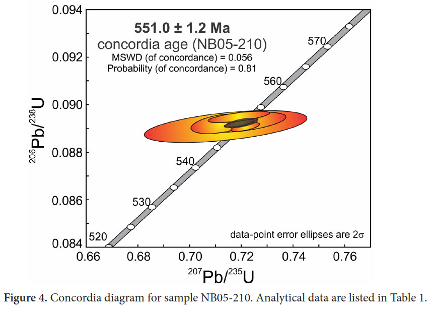
13 The dated sample (NB05-210) was collected from the northern side of Woodland Cove (Fig. 3). It consists of is brecciated feldspar porphyry consisting mainly of plagioclase and rare embayed quartz phenocrysts in a fine-grained granular quartzofeldspathic groundmass. Secondary minerals are abundant, including sericite, chlorite, hematite, and carbonate minerals.
U-PB DATA
14 Sample NB05-210 contained a small number of subhedral zircon grains. Seven single-grain U-Pb analyses by TIMS were conducted on grains of a variety of morphologies and sizes (Table 1). All of the analyses are concordant and overlap one another and yield a mean concordia (Ludwig 1998) age of 551 ± 1.2 Ma (Fig. 4) with no sign of any inherited component. This age is similar to ages of other high-level plutonic and volcanic units that form most of the New River belt, including the Lobster Brook Formation of the Long Reach area (554 ± 6 Ma; Johnson 2001; McLeod et al. 2003), the Leavitts Head Formation (554 ± 3 Ma; McLeod et al. 2003), and the Ragged Falls Granite (555 ± 10 Ma, Currie and Hunt 1991; 553 ± 2 Ma, McLeod et al. 2003).
CHEMICAL AND ISOTOPIC DATA
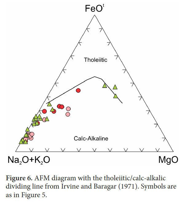
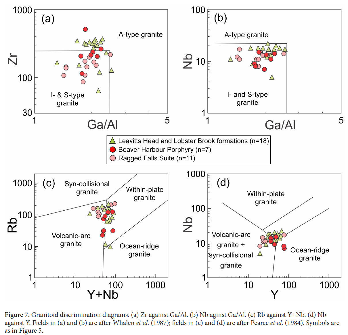
15 The seven samples analyzed from the Beaver Harbour Porphyry display a range in SiO2 from about 60% to over 80% (Fig. 5). Data are quite scattered but generally high in Fe relative to Mg and hence ferroan in the terminology of Frost et al. (2001). They have lower SiO2 than the majority of felsic samples from the other ca. 555–550 Ma volcanic and plutonic rocks of the New River belt which also are mainly ferroan (Fig. 5a). The Beaver Harbour Porphyry samples are subalkaline (Fig. 5b) and display a calc-alkalic trend on the AFM diagram (Fig. 6). Although some analyses plot in the A-type granite field on Figure 5a, their trace element compositions are more characteristic of evolved I-type felsic rocks (Fig. 7a, b), formed in a volcanic-arc setting (Fig. 7c, d). They are similar to the other volcanic and plutonic rocks of the New River belt, as shown for comparison on Figures 5–7. Similarity of the REE patterns of the dated porphyry sample (NB05-210) and a volcanic sample from the Leavitts Head Formation (Fig. 8) further supports a comagmatic relationship between the ca. 555–550 Ma plutonic and volcanic rocks throughout the New River belt. These rocks were likely formed in a volcanic arc on an active continental margin late in the orogenic cycle based on their evolved compositions (Bartsch 2005; Bartsch and Barr 2005). This interpretation contrasts with that of Johnson and Barr (2004), who suggested a within-plate (anorogenic) setting based on a more limited data set.
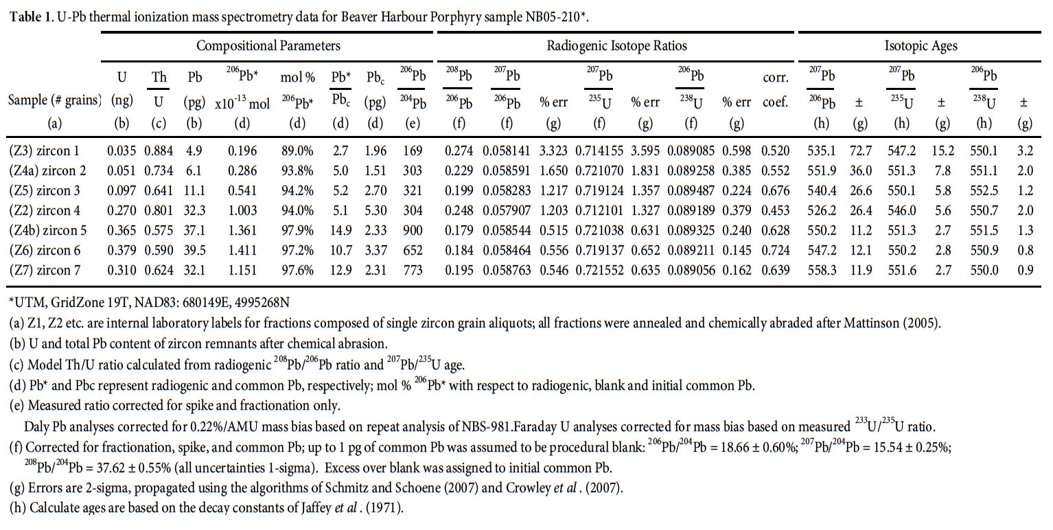 Display large image of Table 1
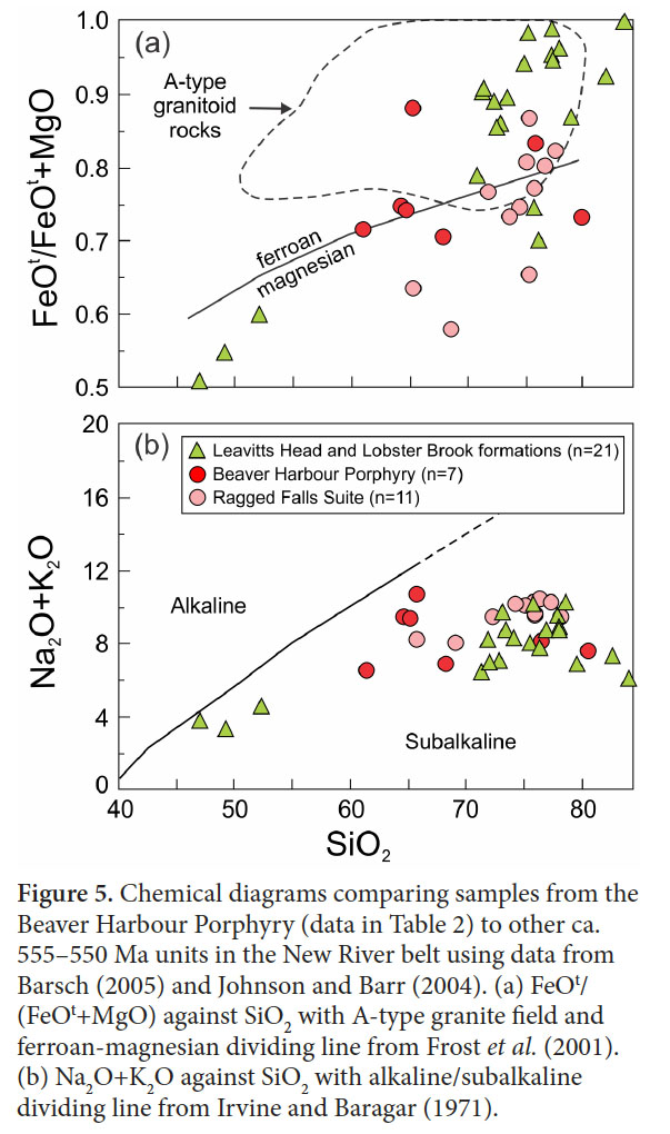 Display large image of Figure 5
16 According to the tectonic model of Bartsch (2005), the ca. 625–620 Ma and ca. 555–550 Ma rocks in the southern part of the New River belt, formed in two separate and unrelated subduction zones, juxtaposed as late as the Devonian, when the Perry Formation was deposited.
 Display large image of Figure 6
17 Based on bimodality of rock types and chemical composition, the ca. 560–550 Ma volcanic and plutonic rocks of the Caledonia belt have been attributed to an extensional setting (e.g., Barr and White 1999; Barr et al. 2003), in contrast to the arc setting suggested here for the ca. 555–550 Ma suite in the New River belt. As pointed out by Barr et al. (2003) and Bartsch (2005), both the ca. 620 Ma and ca. 555–550 Ma suites in the New River belt differ from units of corresponding ages in the Caledonia belt in their overall lithological assemblages, in particular the absence of sedimentary rocks in the New River belt. However, the significance of these differences remains difficult to assess (Barr et al. 2014). The age and tectonic setting for the ca. 555–550 Ma volcanic and plutonic rocks of the New River belt, including the Beaver Harbour Porphyry, are consistent with the age and tectonic setting of the Dipper Harbour Formation and associated subduction-related plutonic rocks of the Brookville belt, suggesting the possibility that they may be related, even though they are now separated by the Silurian Kingston arc belt (Barr et al.2002).
18 The εNd(t) value for the dated sample from the Beaver Harbour Porphyry is slightly negative at -0.5 (Table 3; Fig. 9). Data from three other samples from the New River belt range from -3.7 for a sample from the Simpsons Island Formation to +1.5 for a sample from the Pull and Be Damned Granite, another component of the New River Plutonic Suite (Table 3; Fig. 9). A sample from the Blacks Harbour Granite has ε Nd(622) of 0.4, more juvenile than a previous reported value of -3.13 from the same unit (Barr et al. 2003).
19 Combined with other previously published data (Fig. 9), the range of ε Nd(t) from the New River belt generally support the previous interpretation (Barr et al. 2003) that the underlying crust differs from that under Caledonia, from which ε Nd(t) results are generally more juvenile, although the data overlap (Fig. 9). The overall range of ε Nd(t) data is similar between the New River and Brookville belts, supporting the idea that both are part of Ganderia.
 Display large image of Figure 7
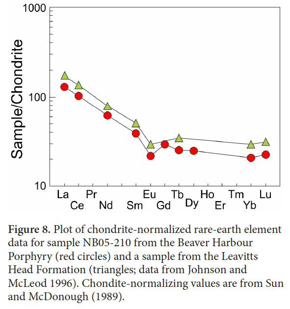 Display large image of Figure 8
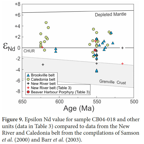 Display large image of Figure 9
CONCLUSIONS
20 The Beaver Harbour Porphyry was previously interpreted to be similar in age to the ca. 620 Ma Blacks Harbour Granite based on their close geographic association and chemical similarities (e.g., Bartsch 2005). However, the U-Pb (zircon) age of 551 ± 1.2 Ma presented here shows that the porphyry is much younger and of the same age as other high-level plutonic and volcanic units that form most of the New River belt. Because both the ca. 620 Ma plutons and ca. 555–550 Ma plutonic and volcanic rocks of the New River belt formed in the same tectonic setting, distinguishing them on the basis of chemical characteristics, including isotopes, appears not to be reliable.
Results presented in this paper are derived in part from the M.Sc. project undertaken by the second author at Acadia University. Project funding was provided in part by the New Brunswick Department of Natural Resources and in part by a Natural Sciences and Engineering Research Council (NSERC) discovery grant to S.M. Barr. We thank journal reviewers Susan Johnson and Les Fyffe for their helpful comments and suggestions.