Articles
The Appledore Island pluton of the Rye Complex, coastal New Hampshire and Maine, USA:
geochronological and chemical evidence for the affinity of an enigmatic terrane
ABSTRACT
The Rye Complex of coastal New Hampshire and Maine is a peri-Gondwanan terrrane that up to now had an uncer- tain origin. An offshore portion of the complex, Appledore Island of the Isles of Shoals, hosts a mainly dioritic intru- sion that yielded an U-Pb zircon age of 361.09 ± 0.14 Ma, allowing comparison of its geochemical characteristics with mafic rocks of similar age across the northern Appalachian orogen. The Appledore Island diorite has similar major, trace, and isotopic compositions as continental rift tholeiite in the Narragansett Basin in southern New England and in the Maritimes Basin of Canada. These intraplate volcanic rocks range from 375 to 330 Ma, bracketing the age of the Appledore Island diorite. Their intraplate tectonic setting reflects regional extension during the Late Devonian to Early Carboniferous which produced successor basins after the Acadian orogeny. The geochemical and age similarities of the Appledore Island diorite and the mafic rocks of the successor basins suggest that the Rye Complex is a basement fragment of a successor basin block. Further evidence of the identity of the Rye Complex is provided by the isotopic composition of intermingled, comagmatic granitic rocks associated with the Appledore Island diorite. The granite has a Ganderian isotopic signature, suggesting that the Rye Complex is a Ganderian basement block that was transposed by movement along the Norumbega Fault System to its position adjacent to the Merrimack Trough of New Hampshire and Maine.
RÉSUMÉ
Le complexe Rye sur les côtes du New Hampshire et du Maine est un terrane périgondwanien dont l’origine était incertaine jusqu’à ce jour. On a découvert dans une partie du complexe en mer, l’île Appledore des îles de Shoals, une intrusion composée principalement de diorite qui a livré un âge par datation U-Pb sur zircon de 361,09 ± 0,14 Ma, permettant de comparer ses caractéristiques géochimiques à celles de roches mafiques du même âge dans l’orogène des Appalaches septentrionales. La diorite de l’île Appledore présente des compositions d’éléments majeurs, traces et isotopiques comparables à celles de la tholéiite du rift continental dans le bassin de Narragansett au sud de la Nouvelle- Angleterre et dans le bassin des Maritimes du Canada. L’âge de la diorite de l’île Appledore se situe dans la fourchette d’âges de ces roches volcaniques intraplaques (de 375 à 330 Ma). Leur cadre tectonique intraplaque correspond à l’extension régionale au cours de la période allant du Dévonien tardif au Carbonifère précoce, qui a produit des bas- sins successeurs après l’orogenèse acadienne. Les similitudes sur le plan de la géochimie et de l’âge de la diorite de l’île Appledore par rapport aux roches mafiques des bassins successeurs semblent indiquer que le complexe Rye constitue un fragment du socle continental d’un bassin successeur. La composition isotopique des roches granitiques comag- matiques entremêlées associées à la diorite de l’île Appledore fournit une autre preuve de la nature du complexe Rye. Le granit a une signature isotopique gandérienne, ce qui tend à indiquer que le complexe Rye est un socle continental gandérien qui a été transposé par le mouvement le long du système de failles de Norumbega à sa position adjacente à la Fosse de Merrimack dans le New Hampshire et le Maine.
[Traduit par la redaction]
INTRODUCTION
1 Problems inherent in the interpretation of orogenic belts include understanding the precise timing and nature of their formation and what processes were involved. Many mountain belts do not result from simple, easily datable crustal plate collisions, but rather from a series of collisions of smaller microplates, volcanic arcs, and seamounts along the leading edge of continental plates. The Appalachian orogen, for example, consists of numerous accreted terranes, each with its own individual tectonic history, that were added to the Laurentian margin over time (Fig. 1 inset; Fig. 2). Temporally, these terranes preserve a record from the Grenville orogeny through a series of late Paleozoic orogenic events, including the Taconic (~550–440 Ma), Salinic (~450–420 Ma), Acadian (~416–356 Ma), Neoacadian (~380–340 Ma), and Alleghanian (~325–280 Ma), that ended with the joining of Gondwana and Laurentia during the Alleghanian orogeny at ~280 Ma (van Staal et al. 2009, 2012).
2 In recent years considerable progress has been made in Canada in characterizing and subdividing broad lithotectonic zones into distinct terranes based on geochemical and other characteristics (e.g., Barr et al. 1994, 1998; van Staal et al.1996, 1998, 2009, 2012; van Staal and Barr 2012; van Staal and Zagorevski 2012; Nance et al. 2008). Although several sub-terranes exist, the two larger terranes or domains that are interpreted to extend southwest through New England are Ganderia and Avalonia (Hibbard et al. 2006; Thompson et al. 1996, 2012; Aleinikoff et al. 2007; Walsh et al. 2007). Ganderia is a Late Neoproterozoic to Early Cambrian arc and subsequent passive margin terrane that rifted from Gondwana at about 505 Ma (e.g., van Staal and Barr 2012). Avalonia, an assembly of several fault-bounded, largely juvenile arc-related belts, may have rifted from Gondwana as much as 30 m.y. after Ganderia, and the two microcontinents had separate histories in the Early Paleozoic (van Staal et al. 2009, 2012). Docking of Gande- ria with composite Laurentia is interpreted to have caused the Salinic orogeny, followed by Avalonia which caused the Acadian orogeny (van Staal et al. 2009, 2012).
3 Most researchers agree that Neoproterozoic rocks of the Boston and Narragansett Bay areas correlate with Avalonia of Maritime Canada (Socci et al. 1990; Skehan and Rast 1995). The Nashoba terrane and the Merrimack Trough, lying adjacent to Avalonia on the west, are now thought to have Ganderian affinities (Wintsch et al. 2007; Kuiper et al. 2013). However, some parts of New England remain poorly understood and their correlation with other Appalachian terranes is not yet determined. One of the more enigmatic of these New England terranes is the Rye Complex of coastal New Hampshire and Maine.
4 The Rye Complex of probable Ordovician or older age (Lyons et al. 1997; Hussey et al. 2010; Kane et al. 2014) lies outboard of the Merrimack Trough and is considered to be a peri-Gondwanan terrane (Fig. 1). Attempts to correlate the Rye Complex with other peri-Gondwanan terranes to the northeast along coastal Maine, however, have been tentative. Possible correlatives include the Cape Elizabeth and Passagassawaukeag formations and/or the Falmouth-Brunswick sequence, based on similar lithologies. Pelite, feldspathic wacke, calc-silicate rock, minor marble, and amphibolite are common to the Rye Complex and their potential correlatives (Bothner and Hussey 1999; Hussey et al. 2010). Uncertain age determinations and limited P-T and isotopic data from the Rye Complex, however, have hindered confirmation of these suggestions.
5 In this contribution, we present geochemistry and geochronology for the Appledore Island diorite that intruded variously deformed metasedimentary and metaigneous units of the Rye Complex. We use these data to compare these rocks to igneous rocks of similar age in coastal New England and Maritime Canada. We also present isotopic data for both the diorite and comagmatic granite that occurs along the margin of the dioritic pluton. The granite is interpreted to represent a partial melt of the host rocks, and as such, may represent the chemical signature of those rocks.
GEOLOGIC SETTING
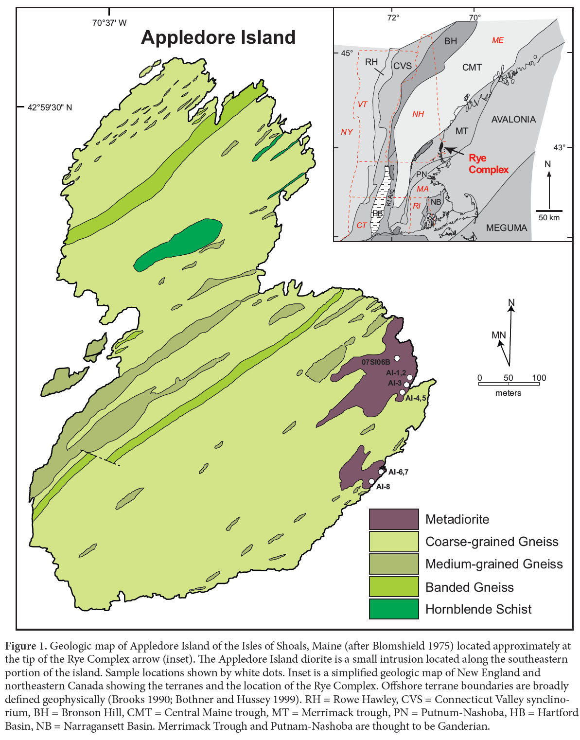
6 The Rye Complex is located east of the Merrimack trough in the Rye anticline of southeastern New Hampshire. Metasedimentary and metaigneous rocks of the complex are variably mylonitized and cut by a number of complex brittle dextral strike-slip faults (Swanson 1995). The onshore part of the complex occupies a relatively small area, spanning a length of ~ 25 km and only 7 km at its widest point (Lyons et al. 1997; Hussey et al. in press). It also crops out in numerous submerged ledges (Brooks 1986, 1990) and on the 9 small islands that compose the Isles of Shoals located ~16 km off the coast of New Hampshire and Maine, increasing its regional extent by well over 400%.
7 Katz (1917) referred to this crystalline area as the Algonkian(?) complex, and Wandke (1922) proposed the name Rye Gneiss. Later, Billings (1956) and Novotny (1963, 1969) used the name Rye Formation and subdivided the unit into an older metasedimentary and younger metavolcanic members. Hussey (1980) showed that the “metavolcanic” member consists of a series of felsic intrusive rocks that crosscut the host at very shallow angles. He also documented the widespread mylonitization of the complex, which has several internal ultramylonite zones, the largest of which is named the Great Commons fault zone in New Hampshire (Carrigan 1984; Swanson 1988). The Portsmouth fault zone bounds the complex on the west and north, everywhere separating it from the adjacent Kittery Formation of the Merrimack belt. Both fault zones are right-lateral ductile shear zones within the Norumbega fault system (Bothner and Hussey 1999; Swanson 1999). Felsic plutonic bodies and abundant associated pegmatite, both variably sheared into near-parallelism with highly mylonitized host rocks, led Lyons et al. (1997) to coin the name Rye Complex. The host complex contains highly sheared quartzofeldspathic gneiss, pelitic schist, and amphibolite (Hussey 1980; Carrigan, 1984; Swanson 2007), all metamorphosed to amphibolite facies. Interlayered metapelite contains garnet, andalusite, and sillimanite, and calcareous rocks contain diopside (Hussey 1980; Carrigan 1984). Rocks within the Great Commons fault system show the most intense mylonitization (Novotny 1969; Carrigan 1984; Swanson 2007).
 Display large image of Figure 1
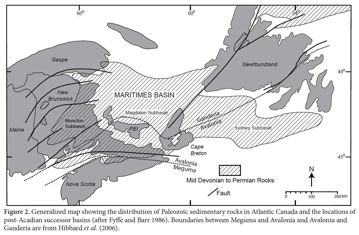 Display large image of Figure 2
8 Because mylonitization is commonly accompanied by increased fluid flow, alteration was expected in both host and intrusive rocks. For this reason, we looked for outcrops as far as possible from the zones of intense mylonitization to minimize the effects of open system behavior and to obtain the freshest samples possible. The Isles of Shoals, located approximately 20 km from the Great Commons fault zone, host a relatively low-grade diorite on Appledore Island. The diorite seems to be the best candidate in the area to provide an original igneous chemical composition.
GEOLOGY AND PETROGRAPHY OF THE APPLEDORE ISLAND DIORITE
9 The bedrock geology of the Isles of Shoals was first mapped by Fowler-Billings (1959) and later by Blomshield (1975). Appledore Island contains the most varied lithologies of the isles including the only diorite. Fowler-Billings (1959) associated the diorite with the larger Exeter Diorite on the New Hampshire mainland. The Appledore Island diorite occupies approximately 0.2 km2 on the eastern shore of Appledore Island in two mappable bodies (Fig. 1). Both are amoeboid in shape with tentacle-like offshoots that exploit the dominant northeast-trending foliation in the host coarse-grained quartzofeldspathic gneiss. The diorite is medium-grained, weakly foliated, and intermingled with grey muscovite-biotite granite (Fig. 3). These rocks are cut by Mesozoic diabase dykes.
 Display large image of Figure 3
10 The Appledore Island diorite was termed metadiorite by Bothner et al. (2009) because of its weak foliation. It contains pleochroic green hornblende which is generally unzoned, although it shows some opaque phase exsolution along cleavage planes and titanite is commonly developed at grain boundaries with biotite. Some amphibole grains show weak zoning from faint brown cores to green mantles and rims (Fig. 4). Weaker pleochroism is characteristic of small grains and in some places the rims of larger grains. Plagioclase is typically quite fresh and preserves strong zoning, a feature that would have been eradicated under intense metamorphism and deformation like that experienced by plutons in the Rye Complex onshore. Minor amounts of sericite are present in some of the more calcic cores.
 Display large image of Figure 4
11 Abundant enclaves of the diorite are present along the southeastern granitic margin of the southern lobe of the pluton. The rounded nature and lack of evidence of brittle morphologies suggests that the two magma types were contemporaneous (Fig. 3). The granite that is mingled with the diorite contains muscovite and biotite of similar size. In places, they are intergrown, suggesting that the muscovite is magmatic rather than secondary (Miller et al. 1981).
ANALYTICAL METHODS
12 Amphibole analyses were obtained using a Cameca SX50 electron microprobe at Brigham Young University (BYU). Bulk-rock major and trace element XRF analyses were done with a Siemens SRS 303 at BYU using fused disks for major elements and pressed powder pellets for trace elements. Additional trace elements were determined by inductively coupled plasma mass spectrometry (ICP-MS) at ALS Chemex, Reno, Nevada.
13 Isotopic compositions of Nd, Sr and Pb were obtained at Memorial University of Newfoundland, using a multicollector Finnigan Mat 262 mass spectrometer in static mode. Nd and Sr isotopic ratios were normalized to 146Nd/144Nd = 0.721903 and 88Sr/86Sr = 8.375209, respectively. The reported 143Nd/144Nd and 87Sr/86Sr ratios were corrected for the deviation from repeated duplicates of the JNdi-1 (143Nd/144Nd = 0.512115; Tanaka et al. 2000) and NBS 987 (87Sr/86Sr = 0.710340) standards. During the course of data acquisition replicates of the standards give a mean value of 143Nd/144Nd = 0.512137 ± 19 (Std dev, n=112) for JNdi-1 and 87Sr/86Sr = 0.710291 ± 25 (Std dev, n=46) for NBS 987. Pb isotopic ratios are reported corrected for mass fractionation. A correction factor of 0.107% per amu was obtained by measuring the deviation from repeated (n=12) analyses of the NBS 981 standard. In-run precisions on all isotopic ratios are given at 95% confidence level. Errors on Nd and Sr isotopic compositions are <0.002% and errors on the 147Sm/144Nd ratio are estimated to be less than 0.1%.
14 The εNd values are calculated using 147Sm/144Nd = 0.1967 and 143Nd/144Nd = 0.512638 values for the present day chondrite uniform reservoir (CHUR). 147Sm decay constant is 6.54 10-12 y-1 (Steiger and Jäger 1977). TDM is calculated using a linear evolution for a mantle separated from the CHUR at 4.55Ga and having a present day εNd value of +10 (Goldstein et al. 1984). Following Stern (2002), samples with 147Sm/144Nd > 0.165 yield unreliable model ages: two of our samples with these high 147Sm/144Nd are not included in the discussion here.
15 Zircon grains were separated from bulk rock samples by standard crushing, heavy liquid, and magnetic separation techniques, and subsequently handpicked under the binocular microscope based on clarity and crystal morphology. To minimize the effects of Pb loss, the grains were subjected to a version of the thermal annealing and acid leaching (also known as chemical abrasion or CA-TIMS) technique of Mattinson (2005) prior to isotope dilution thermal ionization mass-spectrometry (ID-TIMS) analyses using a mixed 205Pb-233U-235U tracer solution (spike). Details of zircon pre-treatment, dissolution and U and Pb chemical extraction procedures are described in Ramezani et al. (2007).
16 U and Pb isotopic measurements were performed on a VG Sector-54 multicollector thermal ionization mass spectrometer at MIT, Cambridge, MA. Pb and U were loaded together on a single Re filament in a silica-gel/phosphoric acid mixture (Gerstenberger and Haase 1997). Pb isotopes were measured by peak-hopping using a single Daly photomultiplier detector and U isotopic measurements were made in static mode using multiple Faraday collectors. Data reduction, age calculation, and the generation of concordia plots were carried out using the method of McLean et al. (2011), and the statistical reduction and plotting pro- gram REDUX (Bowring et al. 2011). Unless otherwise noted, U-Pb errors on analyses from this study are reported as: ±X/Y/Z, where X is the internal error in absence of all systematic errors, Y includes the tracer calibration error, and Z includes both tracer calibration and decay constant errors of Jaffey et al. (1971)
RESULTS OF U-PB ZIRCON GEOCHRONOLOGY
17 Zircons extracted from the sample 07SI06B comprise a homogeneous population of clear long-prismatic grains that are interpreted as magmatic in origin. Some of the grains show inclusions but they were not selected for dating. All six analyzed fractions yielded a concordant cluster (Fig. 5) with a weighted 206Pb/238U mean date of 361.09 ± 0.14/0.21/0.44 Ma (MSWD = 0.39; Table 1).
 Display large image of Figure 5
AMPHIBOLE CHEMISTRY
18 Representative amphibole analyses are listed in Table 2. Compositions range from magnesio-hornblende to actinolitic hornblende (Hawthorne et al. 2012). Some analyses of amphibole rims are actinolite. One sample (AI-11) has anomalous amphibole compositions compared to the other analyzed samples. They are also magnesio-hornblende like the majority of the amphibole from the Appledore diorite, but have higher Ti and moderately higher Al than other amphiboles at equivalent Fe/(Fe+Mg) values (Table 2).
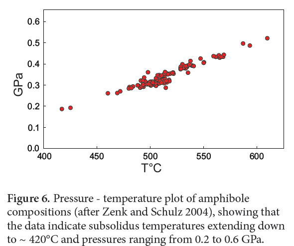
19 Amphibole thermobarometric results (Zenk and Schulz 2004) are plotted in Fig. 6. Temperatures range from 410 to 610° C and pressures from 0.2 to 0.6 GPa. The anomalous amphiboles of sample AI-11 also fall within this range, regardless of their higher Ti and Al contents. This temperature range is subsolidus; the decline in temperature with pressure indicates a clockwise, retrograde path for the pluton. The low temperatures indicate that no igneous amphibole has been preserved; hence the pressure at which the pluton was emplaced is unknown. However, the preservation of retrograde amphibole at 0.6 GPa shows that the emplacement pressure was, at minimum, this high.
 Display large image of Figure 6
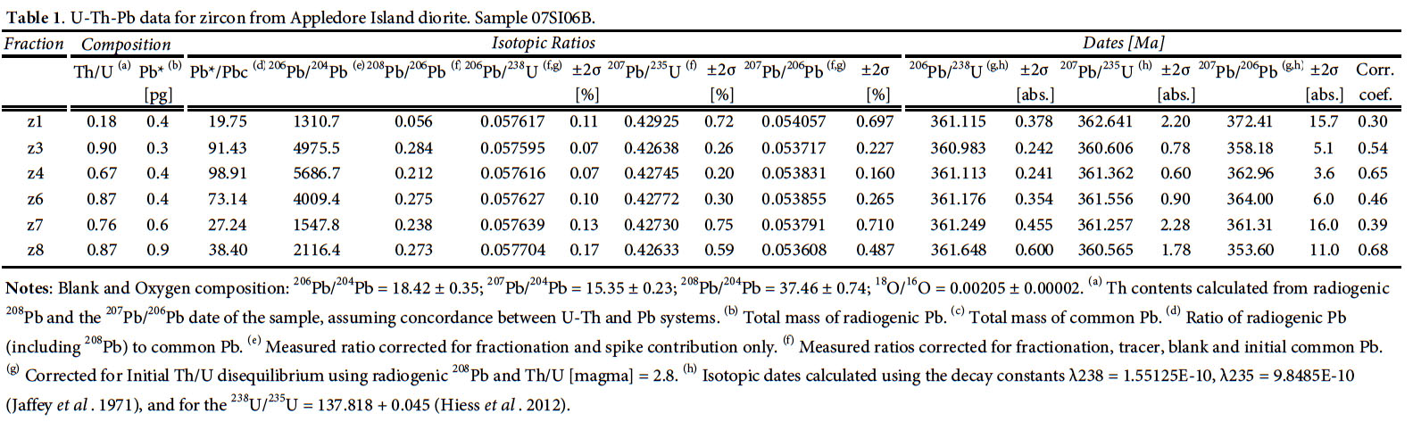 Display large image of Table 1
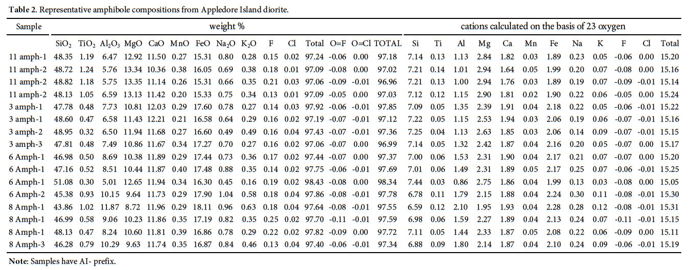 Display large image of Table 2
WHOLE-ROCK GEOCHEMISTRY
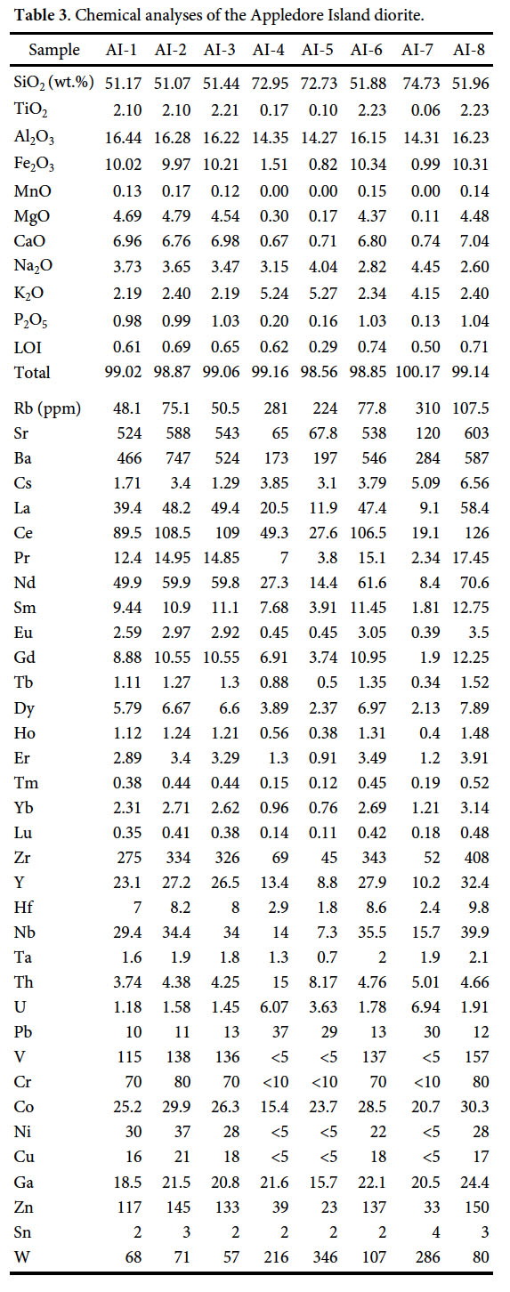
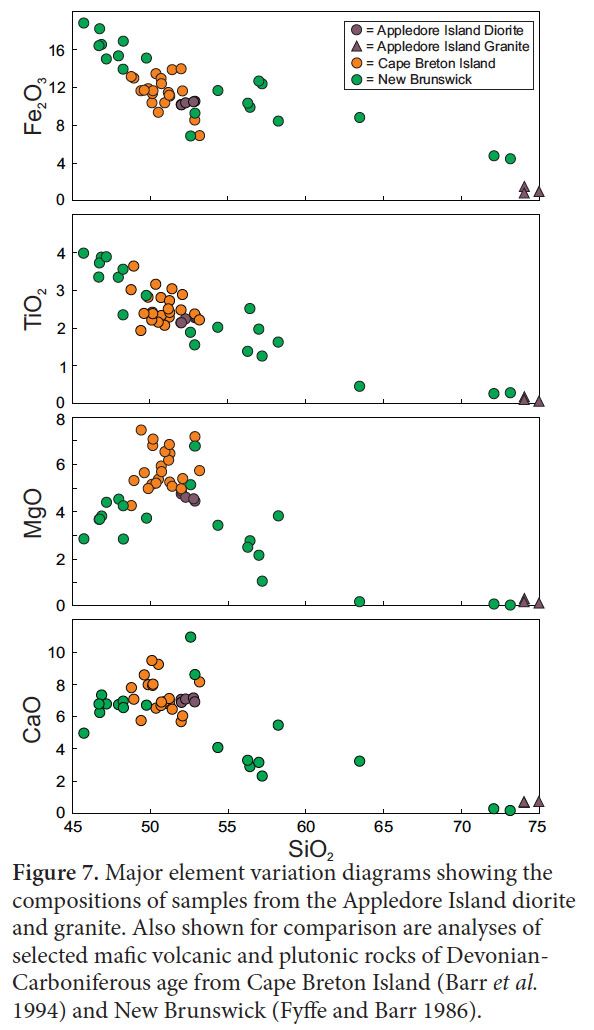
20 The Appledore Island pluton is bimodal but mostly dio-ritic. The five analyzed dioritic samples contain between 50 to 52 wt. % SiO2, whereas the three granitic samples contain between 72 to 74 wt. % SiO2 (Table 3, Fig. 7). The CIPW normative mineralogy of the diorite samples contains normative hypersthene, and the samples range from olivine tholeiite to quartz tholeiite, indicating subalkaline compositions. The granitic samples are slightly peraluminous with 1–2 % normative corundum.
 Display large image of Figure 7
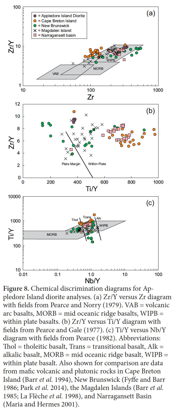
21 On both the Zr versus Zr/Y and Zr/Y versus Ti/Y diagrams (Figs. 8a, b), the Appledore Island diorite samples plot in the within-plate basalt field, and are transitional within-plate basalts on the Ti/Y versus Nb/Y diagram (Fig. 8c). They plot at the edge of the within-plate basalt field on the Ti-Zr-Y diagram (Fig. 9a) and in the within-plate alkalic basalt field on the Nb-Zr-Y diagram (Fig. 9b). Chondrite-normallized REE patterns show slight enrichment in the LREE, ranging between 100 and 250 times chondrites (Fig. 10a). The HREE patterns are relatively flat at about 15 to 20 times chondrite, giving (La/Yb)N values of 11.5–12.7. Eu anomalies are either absent or very small. Multi-element normalized diagrams show moderate enrichment in the most incompatible elements with values near 100 times primitive mantle (Fig. 10b). Compared to neighboring Th and U, Nb is not depleted; no significant negative anomalies are evident. From La to Lu, the patterns show gradual decreasing normalized values.
 Display large image of Figure 8
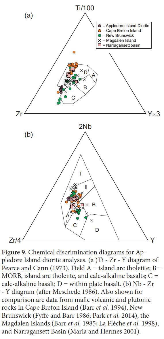 Display large image of Figure 9
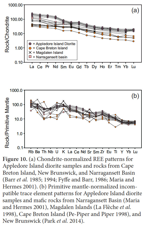 Display large image of Figure 10
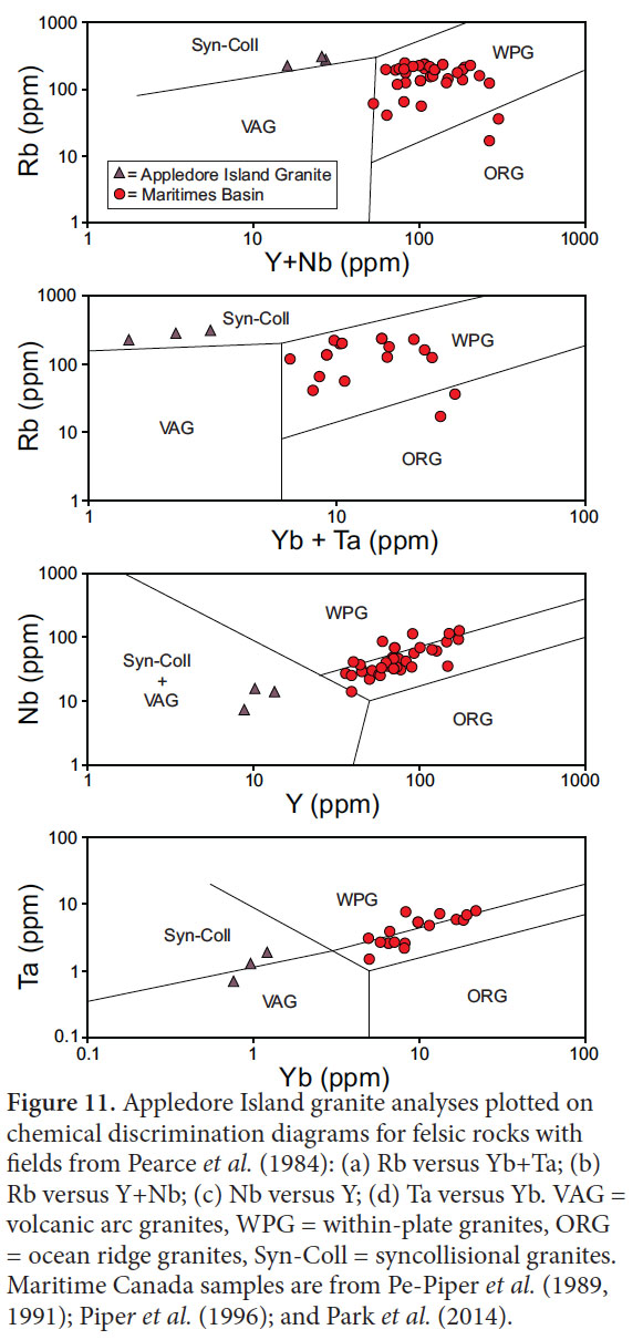
22 Three analyses of granitic rocks that intruded and mingled with the diorite of Appledore Island are plotted in tectonic discrimination diagrams in Figure 11. The granite samples plot in the syn-collisional granite fields.
 Display large image of Figure 11
ISOTOPIC COMPOSITIONS
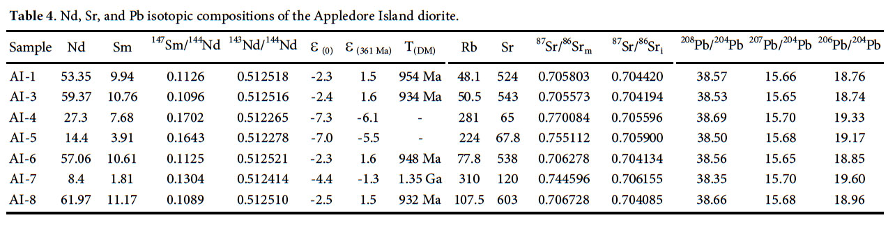
23 The εNd(361 Ma) values in four samples from the Appledore Island diorite are somewhat depleted, plotting at about +2 (Fig. 12; Table 4). Initial 87Sr/86Sr values are near bulk sili- cate Earth, ranging from 0.704085 to 0.704420. In contrast, the granitic samples have negative εNd(361 Ma), ranging from -1.3 to -6.1, with corresponding initial Sr ratios ranging from 0.705596 to 0.706155, considerably higher than the initial Sr ratios of the dioritic samples.
24 Age-corrected 207Pb/204Pb data from diorite and gran- ite samples are plotted against ε Nd(361 Ma) on Figure 13. For reference, the figure also shows fields for Laurentian, Ganderian, and other non-North American (including Ava- lonian) crust as compiled by Tomascak et al. (2005), and a field for Mesozoic tholeiitic basalt from the Central Atlantic Magmatic Province (Pegram 1990). Data from the Appledore Island diorite samples plot in the Mesozoic tholeiite field. The granitic samples from Appledore Island have 207Pb/206Pb values similar to those from the associated dioritic rocks, but have lower εNd(361 Ma) values. Two of the granitic samples plot adjacent to the Ganderian field and one plots in the area of overlap between the Ganderian and Avalonian fields.
 Display large image of Table 4
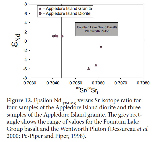 Display large image of Figure 12
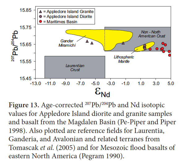 Display large image of Figure 13
DISCUSSION
25 To identify the tectonic affinity of the Rye Complex, we compare the composition of the Appledore Island diorite to mafic rocks of the same age to the northeast in Maritime Canada and the Narragansett Basin to the south. As discussed below, the Appledore Island diorite is the plutonic equivalent of rocks of continental tholeiite derivation across the northern Appalachians whose compositions are indicative of Late Devonian to Early Carboniferous extension. In this contribution, we limit our comparisons to lavas and plutons in coastal New England and Maritime Canada of these same compositional signatures and tectonic settings that were erupted/emplaced in post-Acadian successor basins (Blanchard et al. 1984; Durling and Marillier 1993; Pe-Piper and Piper 2002). These include the ~ 340 Ma basalts of Cape Breton Island (Blanchard et al. 1984; Barr et al. 1994), Carboniferous basalts of New Brunswick (Fyffe and Barr 1986; Park et al. 2014), 385 Ma rocks of the Guysborough area, Nova Scotia (Cormier et al. 1995), 355– 362 Ma basalts of the Magdalen Basin (Barr et al. 1985; Pe- Piper and Piper 1998, La Flèche et al. 1998), 330 to 375 Ma Fountain Lake Group basalts of Nova Scotia (Dessureau et al. 2000), and ~ 370 Ma Wamsutta Formation in the Narragansett Basin of southern New England (Thompson and Hermes 2003).
26 The Maritimes Basin of Atlantic Canada contains basalt, rhyolite, and related gabbro-granite plutons which range in age from ca. 375 Ma to 330 Ma (Dunning et al. 2002), thus overlapping with the age of the Appledore Island diorite. On Harker and tectonic discrimination diagrams, the mafic rocks have within-plate tholeiitic characteristics, and are very similar to the Appledore Island diorite (Figs. 7, 8, 9). The majority of Magdalen Basin samples have lower REE concentrations compared to the Appledore Island diorite but REE patterns are generally parallel to those of the Appledore Island diorite samples (Fig. 10a). Magdalen Island and Cape Breton Island samples have similar normalized multi-element patterns to the Appledore Island diorite (Fig. 10b).
27 The Wamsutta Formation in the Narragansett Basin contains bimodal volcanic rocks (Maria and Hermes 2001) including a 373 ± 2 Ma rhyolite (best estimate from upper Concordia intercept and weighted mean 206Pb/238U and 207Pb/235U ages of Thompson and Hermes 2003). Associated Wamsutta Formation basalts are thus probably somewhat older than the Appledore Island diorite. However, like the diorite they are within-plate tholeiites (Figs. 7, 8, 9). Their LREE concentrations approach those of the Appledore Island diorite samples, but with slightly lower (La/Yb)N values of 7.4–9.1 (Fig. 10a). Two basaltic samples display normalized multi-element patterns similar to those of the Appledore Island diorite samples (Fig. 10b).
28 Basalt of the Fountain Lake Group and gabbro from the Wentworth Pluton from the Cobequid Highlands in the Maritimes Basin yielded εNd(361 Ma) ranging from 1 to 6 (Dessureau et al. 2000; Pe-Piper and Piper, 1998), overlapping with the data from the Appledore Island diorite. Few Sr data are available for mafic rocks from the Maritimes Basin, but initial 87Sr/86Sr values for quartz diorite from the Gilbert-Wyvern pluton of the western Cobequid Highlands range from 0.7069 to 0.7076 (Pe-Piper and Piper 1998). Age-corrected 207Pb/204Pb and Nd isotopic data from the diorite from Appledore Island and volcanic rocks from the Maritimes Basin define a trend extending from the Mesozoic tholeiite field to higher εNd(361 Ma) values of up to 5. All samples of both Appledore Island and the Maritimes Basin have age-corrected 207Pb/206Pb values of ~ 15.6 to 15.65.
29 The similarities in major element, trace element and isotopic compositions and age between the Appledore Island diorite and continental rift tholeiites of Maritime Canada and the Narragansett Basin indicate that the Appledore Island diorite is a component in the extended magmatic episode that was expressed from Rhode Island to Cape Breton Island. Its age is especially similar to that of basalt, rhyolite, and equivalent plutonic rocks in the Cobequid Highlands which have yielded ages of ca. 360–356 Ma (Dunning et al. 2002). Correlation of the Appledore Island diorite with the mafic rocks of the post-Acadian successor basins implies that the rocks of the Rye Complex which it intrudes likely represents the basement of a post-Acadian successor basin, intruded by mafic and felsic magmas related to basin formation. The other basins are filled with sediments and intercalated volcanic rocks, all deposited on peri-Gondwanan basements (Durling and Marillier 1993). But unlike the Late Devonian to Permian successions in the Maritimes Basins where sediments unconformably overlie either Ganderian or Avalonian basement, depending on the location of the subbasin (Hibbard et al. 2006), the Appledore Island diorite intruded a crystalline block that had experienced amphibolite-facies metamorphic conditions (Blomshield 1975). We interpret those rocks as basement; sedimentary and volcanic cover, if ever present, have long been removed. The major question regarding the Rye Complex, then, is this peri-Gondwanan basement Ganderian or Avalonian?
30 With the exception of the peraluminous Black Brook Granitic Suite (Yaowanoiyothin and Barr 1991), the Maritimes Basin contains 360–340 Ma A-type granites (Pe-Piper et al. 1989, 1991; Piper et al. 1996; Park et al. 2014). In contrast, the granitic rocks associated with the Appledore Island diorite are mildly peraluminous with syn-collisional trace element characteristics (Fig. 11). While these data seem to be at odds with the within-plate signature of the comagmatic diorite, the granite signature may not provide an accurate indication of the tectonic setting of the Appledore Island pluton. As shown by Förster et al. (1997), gran- ite geochemistry may instead reflect the tectonic setting of the source rocks. Partial melting in the contact aureole probably occurred by mica dehydration melting reactions, and because both muscovite and biotite have large partition coefficients for Rb (Rollinson 1993), mica breakdown partitions large amounts of Rb into the melt, accounting for the high Rb/Sr ratios and high Rb concentrations with the compositions of syn-collisional granites (Harris et al. 1993). In contrast, partial melting influenced by high water contents causes higher degrees of melting of quartz and feldspar with minimal mica melting, and because feldspars have high Sr partition coefficients and lower Rb partition coefficients than micas, the melt has lower Rb/Sr ratios that melts derived by mica dehydration melting. Thus the Rb/Sr ratios and Rb concentrations are defined by the nature of the melting reaction, which in syn-collisional settings, is dominantly mica dehydration melting. Hence, although the granites of the Appledore Island pluton plot in the syn-collisional fields of Figure 11, they very well may result from mica dehydration melting in the contact aureole rather than a particular tectonic setting. The metasedimentry rocks of the Rye Complex clearly have experienced amphibolitefacies metamorphism at pressures at least as high as those recorded by the retrograde amphibole in Appledore Island diorite, where pressures reached as high as 0.6 GPa. Hence, we interpret the granites of the Appledore pluton to represent partial melts of the Rye Complex basement.
31 The Nd and Pb isotopic data (Fig. 13) suggest that the granites are partial melts of Ganderian sources. One granitic sample, (AI-7), plots in the overlap zone between Ganderia and Avalonia, but the other two samples have εNd(361 Ma) values that are more negative than typical Avalonian basement. Some Avalonian cover sediments have similar low εNd values (Samson et al. 2000; Sakoski et al. 2007), but they are unmetamorphosed sedimentary rocks overlying Avalonian basement. Therefore, the peraluminous granite of the Appledore Island granite is interpreted to be a partial melt of the Rye Complex basement and that basement has isotopic compositions that are more indicative of Ganderia than Avalonia.
CONCLUSIONS
32 The 361.09 ± 0.14 Ma diorite on Appledore Island is compositionally similar to other rift-related, plutonic and volcanic continental tholeiites from the Maritimes Basin of Canada and the Wamsutta Formation of the Narragansett Basin of Rhode Island. The tholeiites are thought to be generated during regional extension after the Acadian orogeny, producing post-Acadian successor basins. Slightly peraluminous granitic rocks occur along the margin of the Appledore Island pluton, and the isotopic composition of the granites indicates that they are partial melts of Ganderian basement rocks. Thus the Rye Complex correlates with other peri-Gondwanan terranes that underwent extension and intrusion of continental rift tholeiites, and the Ganderian isotopic signature of the Appledore Island granitic rocks indicates that the Rye Complex basement is Ganderian.
We are grateful for permission from the Maine Geological Survey to include U-Pb geochronological data obtained for U.S. Geological Survey supported State Map efforts in southwestern Maine. Margaret Thompson, Leslie Fyffe, and journal editor Sandra Barr are thanked for very helpful journal reviews. This work was partially supported with funds from the College of Physical and Mathematical Sciences, Brigham Young University.