Articles
Stratigraphic evolution of provenance in a thick conglomerate-dominated Carboniferous succession in the southern Isle Madame area, Nova Scotia, and paleogeographic implications
ABSTRACT
Thick conglomerate-dominated sedimentary successions of the Horton and lower Windsor groups in the southern Isle Madame area show provenance variations with stratigraphic position, based on pebble counts, petrographic observations, and facies trends throughout the conglomeratic units. These coarse clastic sediments were deposited in a transtensional basin that formed south of a splay of the Minas Fault Zone, now repeated by younger faults in the study area. A stratigraphic section 1300 m thick that includes the base of the Horton Group was derived mostly, if not entirely, from units in the Avalonian Mira terrane to the east. Similar provenance indications continue stratigraphically upward in this section and elsewhere on Isle Madame through the thick lower and central parts of the Horton Group. In the upper part of the Horton Group, an influx of high-grade metamorphic and deformed plutonic clasts is recorded in the conglomerates, and the percentage of this material continues to increase above a dark fine-grained interval and into the overlying Windsor Group. The metamorphic clasts strongly resemble local basement rocks exposed as belts between conglomeratic domains in Isle Madame, indicating that these deeper crustal rocks were unroofed within the former basin in the late Tournaisian, resulting in redirected drainage patterns. Paleocurrent and facies information suggest that the Mira terrane sources were located to the northwest at the time of deposition. Hence, paleogeographic reconstruction for the area involves not only unroofing of the deeper crustal rocks, but also dextral transcurrent movement to place the appropriate parts of the Mira terrane at the northwestern corner of exposed parts of the basin. This movement was along a subsequently deformed part of the Minas Fault Zone.
RÉSUMÉ
Des successions sédimentaires épaisses dominées par le conglomérat du Groupe de Horton et de la partie inférieure du Groupe de Windsor dans le secteur sud de l’Isle Madame montrent des variations de provenance avec la position stratigraphique, selon le compte de galets, les observations pétrographiques et les tendances des faciès dans l’ensemble des unités conglomératiques. Ces sédiments clastiques grossiers ont été déposés dans un bassin transtensionnel qui s’est formé au sud du point de divergence de la zone de faille de Minas, maintenant répétés par des failles plus récentes dans la zone d’étude. Une section stratigraphique de 1 300 m d’épaisseur comprenant la base du Groupe de Horton provenait majoritairement, si ce n’est pas entièrement, des unités dans le terrane de Mira de l’Avalonien à l’est. Des indications de provenance similaire se poursuivent stratigraphiquement vers le haut dans cette section et ailleurs sur l’Isle Madame dans les parties épaisses inférieures et centrales du Groupe de Horton. Dans la partie supérieure du Groupe de Horton, un afflux de clastes plutoniques déformés et hautement métamorphiques est noté dans les conglomérats, et le pourcentage de ce matériel continue d’augmenter au-dessus d’un intervalle à grains fins foncé et dans le Groupe de Windsor sus-jacent. Les clastes métamorphiques ressemblent beaucoup aux roches de socle locales exposées et formant des ceintures entre les domaines conglomératiques sur l’Isle Madame, ce qui indique que ces roches crustales plus profondes étaient exposées dans l’ancien bassin du Tournaisien supérieur, donnant lieu à des réseaux hydrographiques redirigés. Les renseignements relatifs au paléocourant et aux faciès semblent indiquer que les sources du terrane de Mira se situaient au nord-ouest au moment du dépôt. Par conséquent, la reconstruction paléographique de la zone suppose non seulement l’exposition des roches crustales plus profondes, mais également un mouvement de coulissage dextre pour placer les parties appropriées du terrane de Mira au coin nord-ouest des parties exposées du bassin. Ce mouvement s’est effectué le long d’une partie déformée par la suite de la zone de faille de Minas.
[Traduit par la redaction]
INTRODUCTION
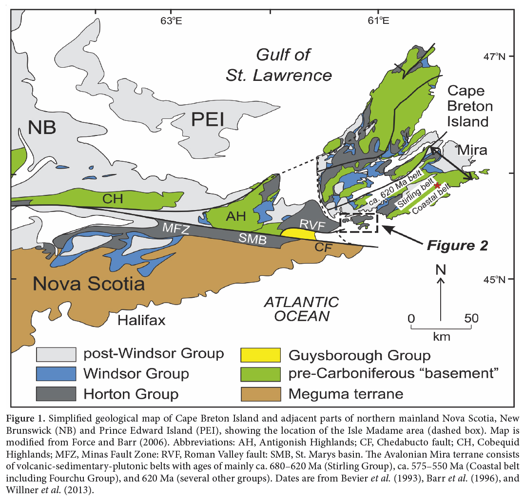
1 Geological compilations of the southern part of Isle Madame (Fig. 1) show belts of steeply dipping conglomerate- dominated sedimentary sequences alternating with belts of crystalline basement rock (White and Barr 1999; Giles et al. 2010; cf. Fletcher 1881) mostly separated by faults (locally as mappable units of fault-rock). Force and Barr (2006) interpreted this map pattern as resulting from juxtaposition and extensional rotation in a transtensional setting related to the Minas Fault Zone (Fig. 2). The conglomerate-dominated sequences are of Early Carboniferous age, mostly belonging to the Horton Group but locally passing up into the Windsor Group (Giles et al. 2010). Measurement of total thickness is complicated by different rotational histories of structural blocks (Fig. 2), thus requiring correlations in conglomeratic sequences, but is estimated to be about 6600 m (Force and Barr 2006; as modified herein).
2 The provenance of conglomerate clasts is complex, as they are not obviously derived from the locally exposed belts of basement rocks except in the Windsor Group. Force and Barr (2012) examined the detrital zircon assemblage of a sandstone bed within a particularly thick and well- exposed Horton Group section dominated by conglomerate. A good match in detrital zircon ages was observed with dated rocks in the Mira terrane (Fig. 1), particularly with the Fourchu Group in the Coastal belt of Barr et al. (1996). Furthermore, the overall detrital zircon assemblage is nearly identical to that of a Cambrian sandstone sample from the Mira terrane (Barr et al. 2012), except for Devonian zircon grains that could have been derived from plutons of that age in the Mira terrane. The results of Force and Barr (2012) seem to indicate Mira terrane sources for not only the sampled horizon, but the entire lower and central parts of the Horton Group of Isle Madame. However, some change in conglomerate provenance is evident toward the top of the 7 km of conglomerate-dominated section, especially in the Windsor Group. Clasts at this stratigrahic level resemble local metamorphic and plutonic basement rocks of the Chedabucto Fault Complex (White and Barr 1999; Force and Barr 2006, 2012). In addition, the Horton Group locally unconformably overlies the Glenkeen Formation of the mid-Devonian Guysborough Group (White and Barr 1999; Giles et al. 2010), which thus is another potential source.
3 This paper builds on the conclusions of Force and Barr (2012), placing them in a more detailed stratigraphic context and correlating the zircon results with coarse-clast petrography. Addressing conglomerate provenance in a stratigraphic context adds an additional dimension to the provenance picture, permitting interpretation of paleoenvironmental and paleogeographic aspects. The plan of this paper is (1) to look at the section from which the detrital zircon sample was taken to establish relations between that sample and provenance characteristics of adjacent conglomerate units, (2) determine the stratigraphic extent to which those characteristics apply, and (3) expand the analysis to the entire Horton and lower Windsor sequence of southern Isle Madame, in order to establish trends and depict changing paleogeographic relations.
 Display large image of Figure 1
 Display large image of Figure 2
METHODS
4 To construct the stratigraphic sequence of Figure 3, the ratio and succession of different rock types and non- exposed intervals was recorded for each interval, emphasizing clast size, shape, and lithotype abundance. Clast imbrication was recorded where three-dimensional exposure allowed.
5 Provenance implications of detrital zircon assemblages of a sand bed at 600 m in this section (Force and Barr 2012) were supplemented by detailed study of coarse-clast assemblage at three other horizons in this section, two below and one above the detrital zircon sample as shown in Figure 3. These studies consisted of (1) 100-clast counts of the entire 3–15 cm clast range, generally from several adjacent beds in a single exposure, (2) description of the coarser population of the site, and (3) thin section study of a gritty bed from each site to verify clast identification, quantify this finer population, and examine details of clast petrology. All thin sections were stained for potassium (K) feldspar. Point-count classes were kept as specific as identification allowed, in order that several classification schemes could be tried.
6 Seven additional pebble counts were performed elsewhere in southern Isle Madame with the same methods as in the Petit Anse-Gros Nez section. Each of them defines a particular stratigraphic transition or paleogeographic position in a sequence that ranges stratigraphically through the Horton Group into the lower part of the Windsor Group. In addition, clast ratios in conglomerates from many more localities were estimated in order to delineate regional stratigraphically controlled provenance trends.
THE PETIT ANSE-GROS NEZ SECTION
Stratigraphic Units
7 The sample for provenance study reported by Force and Barr (2012) was collected from a section about 1330 m thick (Fig. 3) that stretches from Petit Anse toward Groz Nez along the eastern shore of Petit-de-Grat Island (Fig. 2). The base of this section is the unconformity at the base of the Horton Group, so the section represents the entire lower and lower/central part of that group. It is the only section of Horton Group rocks in the area that is sufficiently well exposed (about 70%) to determine a bed-by-bed stratigraphic column. Dips are within a few degrees of vertical, enabling direct measurement between interval boundaries. Beyond the top of the section shown in Figure 3, structural complications have resulted in lesser dips and make meaningful measurements difficult to obtain.
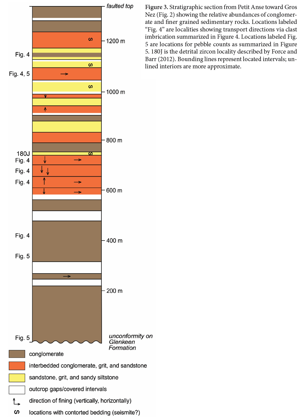 Display large image of Figure 3
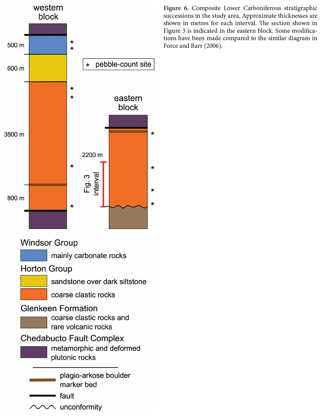
8 The Petit Anse-Groz Nez section shows conglomerate units typically from 10 to 200 m thick, interbedded with sandstone units, commonly argillaceous, with grit interbeds from 0.01 m to over a metre thick. A central interval (Fig. 3) has more sandstone than conglomerate; elsewhere conglomerate predominates. A few light-colored quartz sandstone beds are present, and all show contorted bedding possibly of paleoseismic origin. Some of the conglomerate units coarsen upward. No fossils were found in this section, and there is no evidence for a marine depositional environment. The base of the section rests unconformably on the Glenkeen Formation of the Devonian Guysborough Group (Cormier et al. 1995; White and Barr 1999).
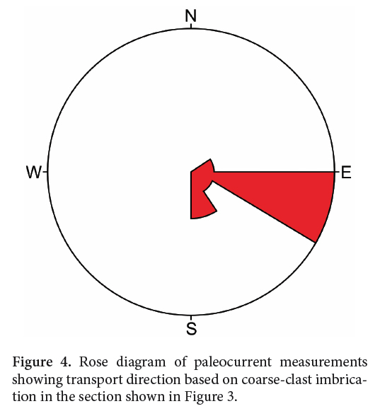
9 Interbedded intervals of conglomerate and finer deposits, mostly of silty sandstone, are especially interesting in this section because in quite a number of places conglomerate is finer, thinner, or pinches out southeastward within the wide outcrop area. Air photo analysis (the finer intervals form long embayed slots) combined with examination of inland road cuts verifies that conglomerate inland (on the west) passes into finer deposits seaward (on the east). This change is consistent with paleocurrent analysis based on clast imbrication in six beds of this section, which show a strong component of southeastward transport (Fig. 4).
 Display large image of Figure 4
 Display large image of Figure 5
Provenance Indications
10 Volcanic and sedimentary rocks dominate the coarseclast assemblage in the three pebble counts done in conglomerate horizons of this section. Felsic to intermediate volcanic clasts are most common; however, these clasts commonly show some phyllitic foliation, which is quite distinct from primary banding or fragment alignment, which are also visible in some clasts. Felsic plutonic clasts are also present, but far less abundant. Sandstone clasts are most commonly feldspathic, with medium-to-coarse arkosic texture. Also common as clasts are quartz sandstone, red and black siltstone, chert, and cataclastic rocks (i.e., fault rock of Force and Barr 2006). Gneissic clasts are rare. The clast compositions are quantified graphically as part of Figure 5.
11 Thin-section examination of grits interbedded with the pebble-counted conglomerate beds yielded additional information on textures and compositions of the clast assemblages. A few predictable problems were revealed, such as gradations between wholly sedimentary clasts and impure tuffaceous clasts. Mafic igneous rocks with microlithic to intergranular texture are ubiquitous but less abundant than more felsic compositions. Especially noteworthy in thin section is the scarcity of potassium feldspar in any of the igneous clast types in this section. Plagioclase is commonly the only feldspar phyric phase in the felsic to intermediate volcanic clasts, including lapilli and vitric tuff and probable ash-flow tuff. As these clasts generally contain quartz, they can broadly be called dacitic. Many of these clasts are also clearly phyllitic with sericitic groundmass. Potassium feldspar is also scarce in felsite clasts in this part of the section.
12 The feldspathic sandstone clasts are also distinctive petrographically; plagioclase is the dominant feldspar (i.e., they could be considered plagio-arkoses). A subsidiary population is of fine sandstone with opaque cement of hydroxides and sulfides. Alteration and veining of clasts with chlorite and minor epidote is common.
13 Potassium feldspar where observed in both igneous and sedimentary clasts is generally fresh, and little textural indication of potassium feldspar loss is present, even where volcanic groundmass is sericitic. Thus dominance of plagioclase over potassium feldspar seems to be an original feature. Barr et al. (1996) similarly noted coexistence of phyric feldspars and sericitic groundmass alteration in rocks of the Fourchu Group.
14 The volcanogenic clasts are interpreted to show a close petrographic match to the rocks in the ca. 575 Ma Fourchu Group, as redefined and described by Barr et al. (1996). The Fourchu Group consists of volcanogenic, largely pyroclastic, rocks of dacitic chemical composition (SiO2/K2O typically about 70), variably foliated, alternating with basaltic sheets. In addition, the fabric and metamorphic petrography of volcanic clasts in the Petit Anse-Gros Nez section broadly match that of low-grade metamorphic rocks of the Fourchu Group as described by McMullin et al. (2010).
15 The plagio-arkose clasts also find a match in the Mira terrane, not in the Fourchu Group but in the adjacent Stirling Group (broadly of ca. 680–620 Ma; Willner et al. 2013) along its northwestern margin. The voluminous litharenite unit (HSla of Barr et al. 1996) of the Stirling Group consists mostly of plagioclase and quartz grains in a medium-to-coarse arkosic texture. The opaque-cemented sandstone clasts similarly match part of unit HSla. This unit contains detrital zircon grains as young as ca. 620 Ma (Willner et al. 2013), thus clarifying the unresolved source of 640 Ma detrital zircons in the sample of Force and Barr (2012).
16 The thin section of a grit sample from 0-5 cm above the unconformity of Horton Group on Glenkeen Formation is especially interesting. In spite of its location at the base of the section, it shows the provenance character of the rest of the Petit Anse-Groz Nez section—dominance by clasts of plagioclase- and quartz-phyric volcanic rocks, many phyllitic, and plagio-arkose, along with lesser cataclastic clasts, consistent with transport from the Mira terrane. The sample lacks any indication of local supply from the rocks on which this section rests unconformably.
17 In summary of provenance indications, the Petit Anse-Gros Nez section, which forms the basal to central parts of the Horton Group, gives evidence of derivation from the northwest and from terranes dominated by slightly metamorphosed volcanic rocks, largely of dacitic composition, and lesser plagioclase-rich sandstone. These characteristics suggest derivation from the Mira terrane, especially the Fourchu Group, and to a lesser extent a litharenite in the Stirling Group, based on descriptions of those units in Barr et al. (1996) and McMullin et al.(2010). This conclusion is supported by the detrital zircon assemblage reported by Force and Barr (2012). Derivation of some clasts from the Devonian Guysborough Group is not precluded, either by the detrital zircon assemblages (as noted by Force and Barr 2012) or by coarse-clast assemblages, which include mafic clasts broadly similar to mafic rocks of the Guysborough Group. However, mafic rocks are ubiquitous in all the candidate source terranes, so there is no compelling reason to invoke Guysborough Group sources in this section, even at its base.
18 Thus it appears that Mira terrane clasts were transported from NW to SE and rest directly on rocks of the Guysborough Group. These basal beds currently face NNE, so primary depositional dip and tectonic dip are obliquely opposed, a result of syndepositional rotation (Force and Barr 2006) of an extensional basin. Supply of Mira terrane clasts was so rapid and/or voluminous that it prograded the entire extensional basin, depositing on its far margin as represented by the Petit Anse-Gros Nez section.
OTHER STRATIGRAPHIC SUCCESSIONS OF THE STUDY AREA
19 The Horton Group - lower Windsor Group succession on Isle Madame is both underlain and overlain by successions that are themselves dominated by conglomerate on Isle Madame (Fig. 2). The oldest, referred to the Glenkeen Formation of the Devonian Guysborough Group (Cormier et al. 1995; White and Barr 1999) by Force and Barr (2006), is the most deformed succession and is cut by granitic rocks of the Petit-de-Grat pluton and by mafic dikes. It formed much of the lower plate for two episodes of detachment (Force and Barr 2006), and as we have seen the Horton Group rests unconformably on it. The youngest succession, equivalent to upper Windsor through Mabou groups strata as shown by Giles et al. (2010), is less indurated, generally fracturing around coarse clasts. Its thickness appears to be at least 500 m, and its accumulation corresponds to extension along the younger of two generations of detachment faults (Force and Barr 2006). Provenance domains for this succession were apparently local; the eastern outcrop area near Pondville is dominated by Avalonian Paleozoic clasts (Boucot et al. 2006), whereas the western area near the Crid Islands (Force and Barr, 2006, fig. 13) is dominated by felsite clasts.
20 The two fault blocks of greatest importance for Carboniferous rocks are shown in Figure 2. The first is west of the Petit-de-Grat fault, i.e., the twice-extended allochthon of Force and Barr (2006). The other block is east of that fault in rocks apparently rotated only by the older period of extension. The fault that separates them is exposed along the eastern shores of Petit-de-Grat harbour (Fig. 2), and exposes a wide zone of gouge-breccia at its northern end.
21 Figure 6 shows the general stratigraphic relations of pertinent rocks in the two blocks. A horizon of coarse conglomerate dominated by angular clasts of medium-grained sandstone characterized by plagioclase grains can be traced through the western block (Cap Auguet) as shown in Figure 7. It probably correlates with a horizon of coarse conglomerate with abundant clasts of similar sandstone exposed along the Rantellau Point-Groz Nez shore, about 2200 m above the base of the Horton Group (or 900 m above the top of the Petit Anse-Gros Nez section). In the western block, the approximate thickness above this sandstone-boulder conglomerate horizon is 4400 m, of which the lower 3000 m consists almost entirely of conglomerate. The overall thickness of the Horton Group succession is thus about 6600 m.
 Display large image of Figure 6
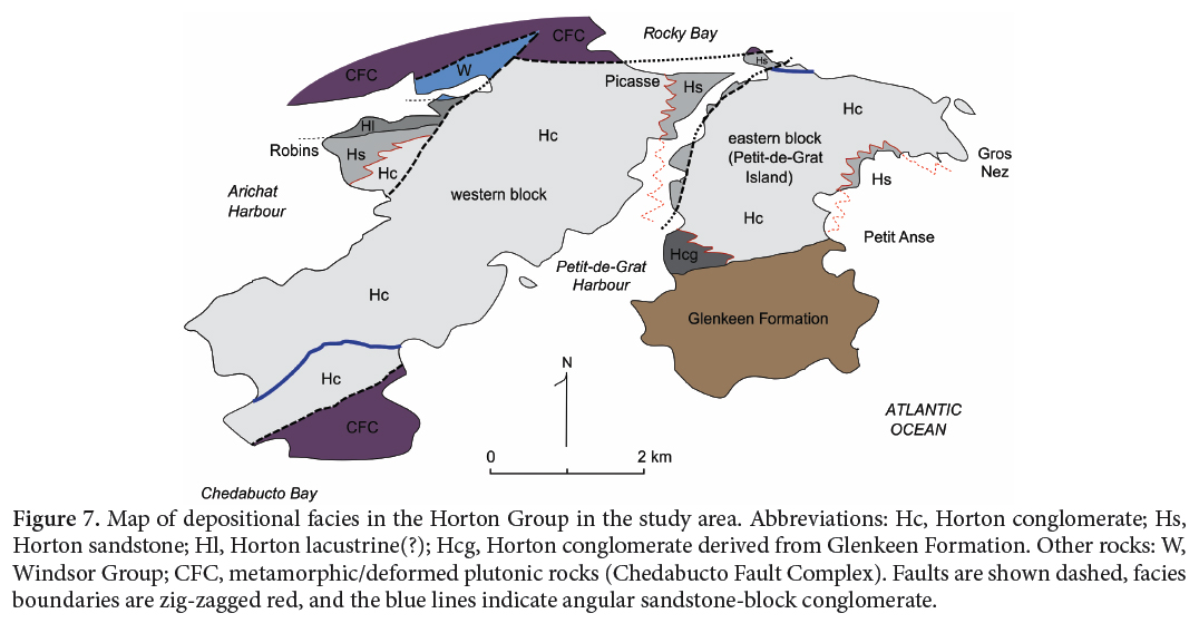 Display large image of Figure 7
22 The base of the Horton Group is also exposed in the Alderney Point area (Figs. 2, 7), along strike to the west from its exposure in the Petit-Anse-Gros Nez section. Unlike at Petit Anse, however, at Alderney Point the unconformity is between arkosic sandstone of the upper part of the Glenkeen Formation, overlain by angular boulder conglomerate of the Horton Group containing abundant clasts of the Glenkeen sandstone, both containing potassium feldspar. This locality is the only one known on Isle Madame where basal Horton Group contains debris of the basement on which it rests.
23 The uppermost part of the sequence in the western fault block contains two distinctive units. The lower of the two is a Horton Group interval that upward from the base consists of (1) interbedded sandstone and conglomerate, (2) uniform gray sandstone, and (3) interbedded sandstone and dark sandy argillite (Figs. 6, 7). This dark argillaceous unit ranges from about 400 to over 600 m thick. At the base of this unit on the eastern margin of the western block, a facies change from conglomerate on the west to gray sandstone interbedded with conglomerate on the east is observed in the area of the Picasse civic center. A similar but oppositely directed facies change at the base of the unit (i.e., conglomerate to the east passing into sandstone to the west) is ap- parent to the west as exposed in the Robin Point area (Figs. 2, 7), but structural complications are possible there. The geometry of these facies suggests an alluvial fan debouching into a lacustrine environment. The finer grained unit has been mapped as the Tracadie Road Formation of the Horton Group (Giles et al. 2010), on the basis of correlation with somewhat similar rocks in the upper part of the Horton Group elsewhere (Teniere et al. 2005). However, physical continuity of the unit to the Tracadie Road type area seems unlikely given the facies variations observed locally (Fig. 7).
24 Overlying the dark argillaceous rocks is the other distinctive unit, consisting of coarse conglomerate of the Windsor Group dominated by angular metamorphic clasts, dominantly gneiss. Locally these conglomerate masses are separated by evaporite rocks (or solution-collapse breccia) and argillite. North of the fault through Arichat (Fig. 2) they are interbedded with calcarenite as at Irish Point. The apparent thickness of this unit is at least 500 m, but it is poorly exposed and its top is faulted. The unit has been assigned to the Windsor Group based partly on its contained microfossils (von Bitter et al. 2006; Giles et al. 2010). The precise location of the boundary between Horton and Windsor groups is unclear in this area.
STRATIGRAPHIC-REGIONAL PROVENANCE TRENDS
25 Compositional variations in coarse-clast assemblages in ten counted localities (including the three described above in the Petit Anse-Gros Nez section) are plotted on Figure 5. Metamorphic, plutonic, and (relatively minor) fault-rock clasts are combined as one end member; the other two end members are volcanic clasts and sedimentary clasts. Clast types are as described for the Petit Anse-Gros Nez section with two main additions. Paleozoic limestone clasts occur in some locations as minor but significant constituents (cf. Boucot et al. 2006). Metamorphic and deformed plutonic clasts are much more abundant near the top of the succession; the former include gneiss and schist and the latter are quartz-feldspar leucogranite. Potassium feldspar is common in the thin sections of interbedded strata containing finer grained clasts.
26 Figure 5 displays a trend from a relatively constant mixture of sedimentary and volcanic clasts near the stratigraphic base and middle of the succession, toward an increased abundance of metamorphic and plutonic clasts near the stratigraphic top. The stratigraphically highest sites, belonging to the lower part of the Windsor Group north of the Arichat fault, are dominated by these clasts. The Horton Group up to about 5000 m above its base (and the entire thickness of the section shown in Figure 3) is dominated by sedimentary and volcanic clasts, with excursions toward sedimentary clasts corresponding to two horizons dominated by large sandstone clasts.
27 The first significant incoming of high-grade metamorphic clasts occurs in the upper part of the Horton Group, about 100 m below the finer-grained dark upper part (as exposed at Picasse and Robins, Figs. 2, 7). In these conglomerates, high-grade metamorphic and deformed plutonic clasts form 10% or more of the detrital assemblage, whereas the ratio of volcanic to sedimentary clasts remains approximately the same as in stratigraphically lower beds. A very few clast imbrications at Robins show transport from the north, suggesting that transport directions are also unchanged. Apparently the provenance change does not coincide with the boundary between the Horton and Windsor groups, but instead with the emergence of new source rocks in the late Tournasian.
28 These new sources correspond to the basement rocks now exposed in narrow fault-bounded belts between conglomerate-dominated sedimentary sequences (Fig. 2). They include metamorphic rocks varying in texture from schist to gneiss and in composition from amphibolite to metapelite, along with several generations of granitic showing either ductile or cataclastic textures, commonly as lit-par-lit injections in the metamorphic rocks. These crystalline rocks have been shown as part of their Chedabucto Fault Complex by White and Barr (1999). Both these basement rocks and related cataclastic zones are commonly veined (in order of age from older to younger) by deformed quartz-sodic plagioclase (boudinaged to form trains of pink clots), quartz-K-feldspar, quartz-chlorite, and carbonate-sericite. Some of this vein paragenesis can be recognized in coarse clasts in the upper part of the stratigraphic sequence, thus suggesting that veining pre-dated deposition of the Windsor Group.
29 Also among the basement rocks is the Devonian Petit-de-Grat Granite containing a distinctive perthitic texture (White et al. 2003), mappable across the southern basement belt (Petit Anse-Ecotrail-Cap Auguet; Fig. 2). How- ever, given that clast transport was to the southeast, this granite was probably not an important source, as extensional tectonics is not likely to have reversed the paleogeographic positions of outcrop areas in the study area (Force and Barr 2006). The Guysborough Group is exposed in the Shaw Point-Irish Point belt of basement rocks (Fig. 2), suggesting that it may be widespread in the subsurface of the area, stratigraphically between basement rocks and Horton Group. However, no clasts derived from the Guysborough Group were identified. Also notably absent as clasts, even in Windsor Group conglomerates, are Lower Carboniferous gabbroic rocks of the Lennox Passage-St. Peters plutonic suite (Barr et al. 1994), which include the distinctive cumulate peridotites of Quetique Island. Either these rocks are too young to be among the sources, or the drainage pattern excluded them, consistent with apparent blockage of Mira terrane sources in the uppermost parts of the succession.
30 Transtensional faulting appears to have exposed basement rocks at the surface within former fans and/or basins that had previously been accumulating erosional debris derived almost exclusively from the Mira terrane. This exposure first occurred in the Late Tournasian but through-transport of Mira debris was almost completely blocked early in the Visean.
31 The provenance trend with stratigraphic position (Fig. 5) is broadly consistent with erosional unroofing of deeper crustal rocks in the source concurrent with conglomerate deposition, as has been observed elsewhere (e.g., Ingersoll 1983). In extensional basins, it is common for sequences to record derivation from two sources representing opposite margins of the basin, as has also been documented elsewhere in Nova Scotia (Hamblin and Rust 1995; Murphy and Hamilton 2000; Murphy 2003). However, in the case of Isle Madame, it seems most likely that mid- to lower-crustal rocks were exposed within a Tournasian basin by continuing extension and transcurrent faulting. Similar exhumation of metamorphic rocks occurred within the Minas Fault Zone to the east in mainland Nova Scotia (White and Barr 1999; Waldron et al. 2005).
PALEOGEOGRAPHIC EVOLUTION
32 The appearance of high-grade metamorphic debris in the stratigraphic sequence approximately coincides with the occurrence of dark argillaceous deposits that are probably lacustrine. The Horton Group conglomerates below this interval were derived from the northwest and north, where Force and Barr (2006) suggested that a transtensional breakaway headwall was located. This study suggests that Mira-terrane rocks occupied this headwall source area. Above the level of dark argillaceous deposits, gneissic local sources are predominant in conglomerate clast assemblages; sources of these clasts currently crop out both north and south of the conglomerates derived from them.
33 Emergence of these local sources, and deposition of its fan-like deposits in the midst of fans derived from the former source, apparently blocked the former dispersal pattern, and in a basin that tilts northward as it fills, would have formed a basin south of the blockage (Fig. 8). This basin was the apparent depocenter of the dark argillaceous deposits. The occurrence of some clasts of high-grade metamorphic rock stratigraphically below this interval may record the progressive emergence of the new source, prior to its effective blockage of former drainage.
 Display large image of Figure 8
34 The lower Carboniferous conglomerate successions on Isle Madame record a snapshot of a time when Miraterrane rocks across the Minas Fault Zone were a source area northwest of the basin represented by the study area. The transtensional structure that permitted the formation of this basin is probably represented by the first-stage fault rocks that later emerged within the basin due to subsequent extensional faulting (Force and Barr 2006).
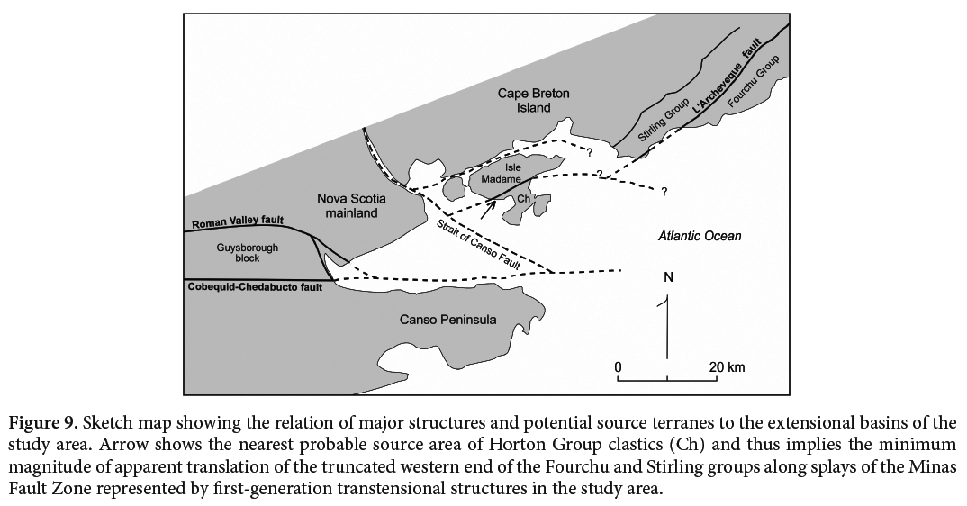
35 Conglomerates of the study area are separated from potential Mira sources by structures now concealed by the Strait of Canso and Chedabucto Bay to the north and west (Figs. 1, 2) and by Lennox Passage and St. Peters Bay to the north and east (Fig. 2), making reconstruction problematic. We know that splays of the Minas Fault Zone both north and south of the eventual Cobequid-Chedabucto fault zone were active in the early Carboniferous (Roman Valley fault, West River St. Marys fault), and include transtensional basin-bounding structures (Webster et al. 1998; Murphy 2003; Waldron et al. 2005). Alternating transtensional and transpressional sites along curving precursor transcurrent structural zones are exposed along the Minas Fault Zone to the east and may have been present around the study region; all of these structures were further deformed (cf. Webster et al. 1998; Waldron et al. 2005) and offset on faults (Figs. 1, 2, 9).
36 Emergence in the study area of new source terranes in the middle of a former basin of Late Tournasian-Early Visean age, followed by reconfiguration of transtensional structures later in the Visean, is typical of the history of the Minas Fault Zone (Waldron et al. 2005). That high-grade metamorphic rocks find their way into the zone is also typical (Cormier et al. 1995; White and Barr 1999; Waldron et al. 2005). However, the Isle Madame area is unusual in that such rocks formed the source of conglomerates in the lower Windsor Group. The province-wide association of high-grade metamorphic rocks with the Minas Fault Zone suggests that the flower structures, both positive and negative, associated with the zone have stems tapping mid- to lower-crustal levels. Unlike basins formed on the southern margin of the Minas Fault Zone on Meguma terrane crust, the study area on its northern margin can be regarded as recording the early transtensional origin of the Maritimes Basin that extends far to the north and lasted many million years longer (e.g., Gibling et al. 2008).
37 The Fourchu Group and part of the Stirling Group of the Mira terrane served as major sources of clasts in most of the sequence described here, based on abundant foliated volcanogenic clasts of dacitic composition, plagio-arkosic clasts, and detrital zircons of appropriate age. Placing the Fourchu and Stirling groups together at the northwestern corner of the basin as implied by sedimentary transport directions in the basin requires transcurrent motion on faults of the Minas Fault Zone system, as both of these groups presently crop out to the east of Isle Madame and are absent in the part of the Mira terrane north of the study area. Given the distribution of rock units and faults shown in Figure 9, approximately 25 km or more of dextral motion is required to move the appropriate parts of the Mira terrane from their required former locations to their present locations. The trace of an appropriate structure to accomplish such a move is a puzzle, though aeromagnetic maps do verify that both the Fourchu and Stirling groups are truncated in St. Peters Bay. The curvature required of such a structure might seem problematic but is actually similar to the curvature of known former Minas Fault Zone traces, such as the Roman Valley fault (Fig. 9).
 Display large image of Figure 9
38 The presence of clasts derived from the Stirling Group in the Horton Group conglomerates of Isle Madame implies that movement along the L’Archeveque fault alone cannot solve the paleogeographic problem; apparently the Mira terrane was already a coherent unit at the time. Probably this fault (Fig. 9) is mostly pre-Horton Group. Which fault in the Isle Madame area represents the headwall boundary with the Mira terrane is unclear, though Horton Group conglomerates with similar provenance on the north shore of the Bay of Rocks suggest that the Lennox Passage structure (Fig. 2), known to be deep-seated and pre-Windsor Group, is most likely.
39 This proposed sense and magnitude of motion is consistent with general knowledge of the Minas Fault Zone; our Tournasian-Visean snapshot postdates the main dextral juxtaposition of Meguma and Avalonian terranes (Murphy and Keppie 1998; Murphy et al. 2011) but records continued transtensional movement with a considerable transcurrent component, apparently greater than the dip-slip component of 6.5 km that is based on the thickness of its Horton Group synextensional deposits. The implied angle of slip on a vertical zone plunges about 13 degrees to the east. The controlling structures are now deformed, as are other ancestral faults of the Minas Fault Zone.
CONCLUSIONS
40 The Mira terrane, particularly its Fourchu Group and a sandstone unit in its Stirling Group, was the predominant source of both conglomerate clasts and zircon grains for most of the thick conglomerate-dominated Horton sequence in the entire southern Isle Madame area. Locally, Mira-derived erosional debris was even deposited directly on bedrock of the terrane to the south. In the Late Tournasian, the transtensional component of Minas-zone faulting that permitted this thick accumulation exhumed local basement sources within the developing basin, blocking growth of Mira-derived fans and contributing their own erosional debris to the top of the pile. Coherent paleogeographic reconstruction also implies dextral transcurrent displacement of the study area (as noted by Force and Barr 2012), presumably along now-deformed splays of the Minas Fault Zone.
Thanks are due to Sandra Barr, Peter Giles, and an anonymous journal reviewer for suggested improvements to the text, and to Chris White for his work on the figures.