Articles
Lower Devonian glacial erratics from High Mountain, northern New Jersey, USA:
Discovery, provenance, and significance
ABSTRACT
Large, fossiliferous, arenaceous limestone glacial erratics are widespread on High Mountain, Passaic County, New Jersey. Analysis of the invertebrate fossils along with the distinct lithology indicates that these erratics belong to the Rickard Hill Facies of the Schoharie Formation (Lower Devonian, Tristates Group). Outcrops of the Rickard Hill Facies of the Schoharie Formation occur in a narrow belt within the Helderberg Mountains Region of New York due north of High Mountain. Reconstruction of the glacial history across the Helderberg Mountains Region and New Jersey Piedmont indicates that the Rickard Hill Erratics were transported tens of kilometers from their original source region during the late Wisconsinan glaciation. The Rickard Hill Erratics provide a unique opportunity to reconstruct an additional element of the complex surficial geology of the New Jersey Piedmont and High Mountain. Palynology of kettle ponds adjacent to High Mountain along with cosmogenic-nuclide exposure studies on glacial erratics from the late Wisconsinan terminal moraine and the regional lake varve record indicate that the final deposition of the Rickard Hill Erratics occurred within a few thousand years after 18 500 YBP.
RÉSUMÉ
Les grand blocs erratiques fossilifères apparaissent disperses dans les formations basaltiques de Preakness (Jurassique Inférieur) sur le mont High, dans le conte de Passaïc, dans l’État du New Jersey (NJ). Ces blocs erratiques sont constitués de légères du brun au jaune, calcaires gréseux et contiennent des couches fossilifères avec des empreintes d’invertébrés. L’analyse de ces fossiles, incluant : rostroconchia, brachiopodes, pélécypodes, coraux, bryozoaires, céphalopodes nautiloide et trilobites autant que la distinction lithologique, indique que ces blocs erratiques appartiennent au groupe Tristates du Dévonien Inférieur et de la Formation de Schoharie du Faciès de Rickard Hill. Les affleurements de la Formation de Schoharie du Faciès de Rickard Hill sont disposés sur une fine couche dans la chaîne de Helderberg dans l’État de New York directement au nord du lieu de découverte des blocs erratiques sur le mont High. La reconstitution de l’histoire glacière de la chaine de Helderberg et du Piedmond, dans l’État du New Jersey, indique que les blocs erratiques du Faciès de Rickard Hill ont été transportés sur des dizaines de kilomètres depuis leur localisation d’origine, pendant la glaciation du Wisconsinan. Les blocs erratiques du Faciès de Rickard Hill fournissent une occasion de reconstituer des éléments additionnels à la géologie complexe de la surface du Piemond, dans l’État du New Jersey, et du mont High. La palynologie des lacs de kettle adjacents au mont High, les études sur l’exposition aux nucleïdes cosmogénique des blocs erratiques ainsi que l’analyse des varves des lac régionaux, indiquent que les derniers dépôts de blocs erratiques du Faciès de Rickard Hill dateraient de quelques milliers d’années après 18 500 ans BP.
[Traduit par la redaction]
INTRODUCTION
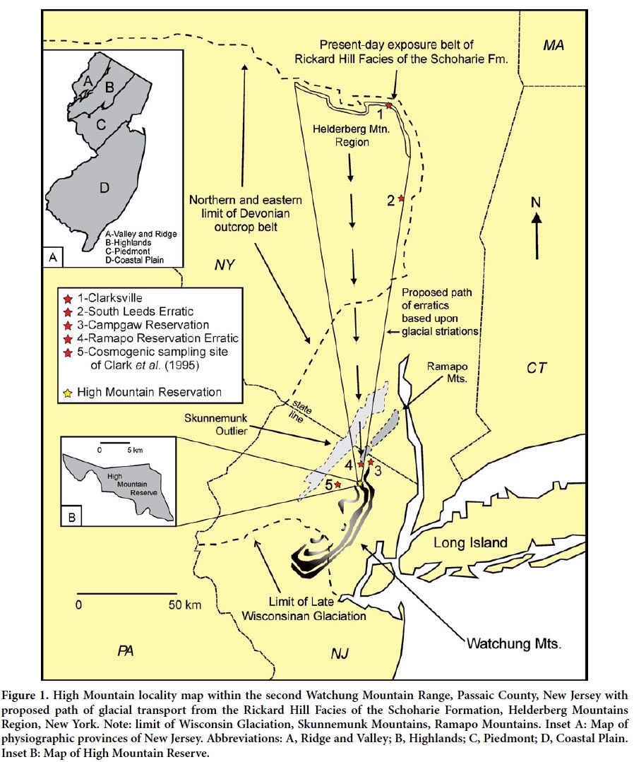
1 For almost one hundred and fifty years, New Jersey’s glacial geology has been the subject of intensive study. As early as 1868, G.H. Cook documented the effects of glaciation throughout the northern third of the state utilizing earlier models proposed in Agassiz’s (1840) historic text on glacial theory. Cook (1868) also provided the foundation for many benchmark studies on glaciation in New Jersey (e.g., Salisbury 1902; Leverett 1928; MacClintock 1940; Widmer 1964; Wolfe 1977; Stone et al. 2002). North of the late Wisconsin terminal moraine (Fig. 1), numerous erosional and depositional features of glacial origin are scattered throughout the landscape, sometimes in heavily urbanized areas (Stone et al. 2002). Ultimately, all aspects of the state’s surficial geology have been influenced by Pleistocene glacial cycles including the role of sea level cyclicity and meltwater drainage in the formation and modification of the Coastal Plan (Fig. 1).
 Display large image of Figure 1
2 The occurrence of glacial erratics in New Jersey transported from distant regions was first noted by Cook (1868) who identified gneiss, granite gneiss, conglomerate and “fossiliferous” boulders that differed from the regional bedrock. Cook (1868) indicated that some of these erratics were enormous, weighing thousands of kilograms, and transported tens of miles from their nearest potential source regions. In this same study, he further described boulders containing fossils that belonged to the “Paleozoic Formation, and usually to that portion which is found in place only to the northwest of the Kittatinny Mountains.” Since this time, many well-known glacial erratics in New Jersey, such as Tripod Rock and Pyramid Mountain near Boonton and “The Rock” of Glen Rock, have been popularized in both scientific and mainstream literature (e.g., Salisbury 1902; Lewis 1940; Wolfe 1977; Raymo and Raymo 2001). However, few reports subsequent to Cook (1868) indicate the presence of fossils in glacial erratics or suggest their potential source regions.
3 In this paper, we describe an assemblage of fossiliferous glacial erratics recovered from till lying above the Preakness Formation (Lower Jurassic) on High Mountain, Passaic County, New Jersey. These erratics are comprised of arenaceous limestone and contain an assemblage of invertebrate fossils diagnostic of those belonging to the Lower Devonian Rickard Hill Facies of the Schoharie Formation, Tristates Group (Linsley 1994). Outcrops of the Rickard Hill Facies of the Schoharie Formation occur in a narrow belt within the Helderberg Mountains Region of New York due north of the High Mountain recovery location for these erratics (Fig. 1). The distinct fossil assemblage and recovery location provides a unique opportunity to reconstruct the glacial history of these erratics.
GEOLOGIC SETTING AND FIELD COLLECTION TECHNIQUES
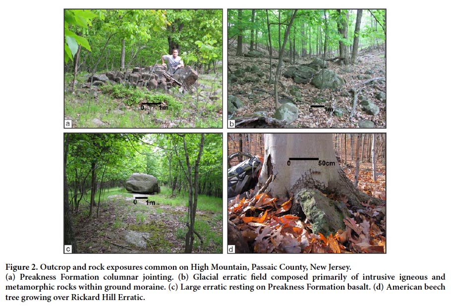
4 The fossiliferous erratics described in this report were recovered within the Piedmont physiographic province from till deposited in the form of ground moraines along valleys within the second Watchung Mountain in High Mountain, Passaic County, New Jersey (Fig. 1). The Watchung Mountains form three prominent topographic features in the western portion of the Piedmont province of New Jersey and are bordered on their eastern and western slopes by valleys of more-easily eroded arkosic shales, sandstones and fanglomerates. Bedrock of the second Watchung Mountain is comprised almost exclusively of basalt and fine-grained gabbro and belongs to the Lower Jurassic Preakness Formation (Volkert 2006; Fig. 2). High Mountain occurs within the Paterson, New Jersey, 7.5 minute Quadrangle and the bedrock exposed there strikes northeast with a shallow dip to the northwest (Volkert 2006). To the north and west, the Piedmont province terminates against the Ramapo Fault and Precambrian metamorphic rocks that comprise the Highlands physiographic province. Paleozoic clastic sedimentary rocks and their metamorphic equivalents occur in the Valley and Ridge physiographic province, to the north and west of the Highlands province, and well to the north and west of the Piedmont province. Cenozoic unconsolidated cobbles, sands, silts and clays of the Coastal Plain physiographic province that were not covered by glacial ice during Pliocene-Quaternary glaciation reside to the south and east of the Piedmont province (New Jersey Department of Environmental Protection 2013).
 Display large image of Figure 2
5 Northern New Jersey records terminal moraines of the Pre-Illinoian, Illinoian, and Wisconsin glaciations (Stone et al. 2002). Landform modifications made by the Pre-Illinoian and Illinoian glaciations occur to the west and south of the High Mountain study area. The terminal moraine of the late Wisconsin glaciation that delineates the maximum advancement of continental glaciation in New Jersey is approximately 35 km to the south of High Mountain in Summit, New Jersey. A surficial geologic map of the Paterson 7.5 minute Quadrangle that includes High Mountain was compiled by Stanford (2003). This map indicates that the sediments found on High Mountain consist primarily of the late Wisconsin Yellow Phase of the Rahway Till. According to Stanford (2003), the Rahway Till, Yellow Phase, consists of reddish-yellow, yellow, very pale brown silty-sand, sandy-silt and silt with rounded to sub-rounded pebbles, cobbles and boulders composed primarily of weathered basalt, gneiss, red sandstone and purple quartzite. The unit achieves thicknesses up to 18 m (60 ft), though it is generally less than 6 m (20 ft) thick on High Mountain (Stanford 2003).
6 Two lobes of the Laurentide Ice Sheet existed in northern New Jersey during the late Wisconsinan glaciation: the Hackensack Lobe east of the Watchung Mountains and the Passaic Lobe west of the Watchung Mountains (Stanford 2007), with the Hackensack Lobe extending farther south than the Passaic Lobe, it being blocked by the Watchung Mountains. These lobes were most likely split by the resistant bedrock of the Ramapo Mountains near the New Jersey-New York boarder (Fig. 1). During this time a number of glacial lakes also formed due to blockage of drainage by the two lobes. In general, these lakes are referred to as the various stages of glacial Lake Passaic, and include the Chatham, Moggy Hollow, Great Notch, and Totowa stages from oldest to youngest, occurring between ~22 000–18 000 YBP (Stanford 2007). The Chatham stage of Lake Passaic formed when the advancing Hackensack Lobe blocked drainage through the Passaic Valley and formed a spillway at elevations between 75–90 m (250–300 ft) above MSL in elevation, draining down the Blue Brook Valley (Stanford 2007). As the Hackensack Lobe continued to advance southward, it eventually fully blocked the Blue Brook Valley at Short Hills Gap, forming the Moggy Hollow stage of Lake Passaic at elevations of 104–125 m (340–410 ft) above MSL (Stanford 2007). As the ice began to retreat, it uncovered a gap in the First Watchung Mountain known as Great Notch and the lake level dropped catastrphically ~24 m (~80 ft) to the Great Notch stage with elevations of 96–79 m (320–260 ft) above MSL (Stanford 2007). Finally, once the ice was fully retreated from the area and the Great Notch stage of Lake Passaic drained, a number of post-glacial lakes existed for a time, the largest of which is known as the Totowa stage with elevations of 64–52 m (210–170 ft above MSL (Stanford 2007)). Eventually the water from Lake Passaic fully drained through gaps in the terminal moraine, leaving behind the area known as the Great Swamp (Stanford 2007).
7 The conspicuous fossiliferous lithology of the Rickard Hill Erratics was first noticed by the first author while hiking on the High Mountain Reserve. Over the past five years, a series of transects were made across nearly the entirety of the High Mountain Reserve with specific focus on erratics concentrated in ground moraines and till deposits. Besides erratics of relatively local lithologies previously noted by Stanford (2003), erratics of nearly the entire Lower Paleozoic stratigraphic column (Upper Ordovician–Middle Devonian) of the mid-Hudson Valley region of New York State were discovered on High Mountain. Rickard Hill Erratics are the most abundant and largest in size, numbering near 100, with erratics of the Middle Devonian Mount Marion Formation being second most abundant (~50 samples thus far). A handheld GPS unit was used to document Rickard Hill erratic locations, although no particular pattern of concentration or distribution was observed. Samples of fossils were collected from larger erratics and specimens are reposited in the paleontological collections of the Department of Geology at SUNY New Paltz, New York. A thorough search for erratics was also conducted in a number of wilderness preserves inferred to be in line with the hypothesized travel path for the Rickard Hill Erratics to both the north (Campgaw Reservation) and south (Garret Mountain Reserve, Mills Reservation, Eagle Rock Reservation, South Mountain Reservation, and the Great Swamp near the late Wisconsinan terminal moraine) of High Mountain (Fig. 1). All sites south of High Mountain yielded only high-temperature/pressure metamorphic and igneous erratics, whereas the Campgaw Reservation near Mahwah to the north of High Mountain, New Jersey, did yield several Rickard Hill Erratics.
DESCRIPTION, FOSSILS, AND PROVENANCE OF THE RICKARD HILL ERRATICS
8 The assemblage of Rickard Hill Erratics consist nearly 100 specimens ranging in size from a few centimeters to over one meter across their longest dimension, with the largest erratic weighing fifty-two kilograms (Fig. 2a, 2b). Exterior surfaces are light tan to yellow, leached arenacous limestone with evidence of rounding and are generally weathered to a depth of several centimeters. Interiors of the Rickard Hill Erratics are generally blue to gray, exceedingly hard and well-cemented limestone, and typically contain the best-preserved invertebrate fossils. In many instances, multiple smaller fragments clearly eroded from larger boulders/ cobbles were recovered in the nearby vicinity and indicate onsite physical erosion.
9 Abundant invertebrate fossils preserved as casts and molds occur throughout the Rickard Hill Erratics (Fig. 3). A taxonomic list of these fossils is given in Table 1. Some of the most noteworthy invertebrate fossils found on the Rickard Hill Erratics are those belonging to Michelinoceras sp., the largest of which is 32 cm in length. In one instance, the body chamber of a Michelinoceras sp. was filled with sediment as well as casts and molds of brachiopods. These taphonomic conditions indicate that the nautiloid was transported on the seafloor with other invertebrate exoskeletons as a shell lag prior to final burial.
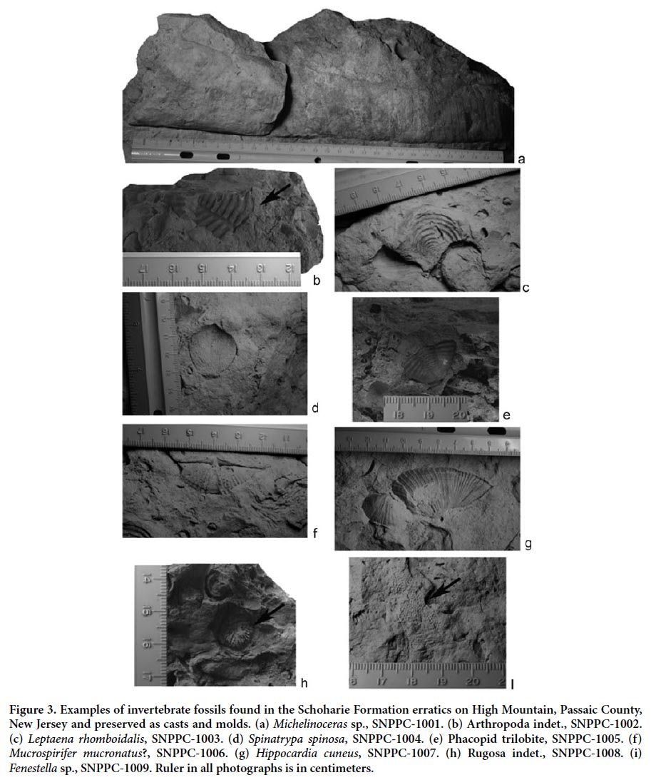 Display large image of Figure 3
10 All invertebrate fossils observed are typical of those found in shallow, marine shelf formations of the Lower and Middle Devonian of New York as detailed by Linsley (1994). The presence of the large rostrochonch Hippocardia cuneus in association with several taxa of large orthoconic nautiloids and a variety of brachiopods distinctly narrows the likely formation of origin to the Schoharie Formation of Late Emsian (latest Lower Devonian). Combining lithology with fossil content, it is possible to further narrow the likely area of origin to the Helderberg Plateau area of northern Schoharie and northeastern Albany counties. Specifically, we identify these erratics as belonging to the Rickard Hill Facies of the Saugerties Member of the Schoharie Formation, sensu Ver Straeten and Brett (2006). Exposures of this unit were visited in the vicinity of Clarksville in Albany County, New York, and the similarity of fossil content and lithology of the exposures and the erratics from High Mountain was nearly identical (Fig. 4). It is important to note that nearest outcrops of fossiliferous Late Emsian strata to High Mountain are exposures on the northern end of the Skunnemunk-Green Pond outlier, a long hill trending roughly NE-SW, ~30 km due north of High Mountain (Fig. 1). At this locality, the Late Emsian strata consist primarily of deformed dark-grey to rusty-weathering shales, silts, and sandstones (Boucot et al. 1970). Due to the distinct lithology, mode of preservation, and fossil assemblages found in the erratics herein described, it is definitely possible to rule out the Skunnemunk-Green Pond exposures as the source area. While it is fully possible that erratics from the strata exposed in the Skunnemunk-Green Pond outlier exist on High Mountain, they have yet to be positively identified.
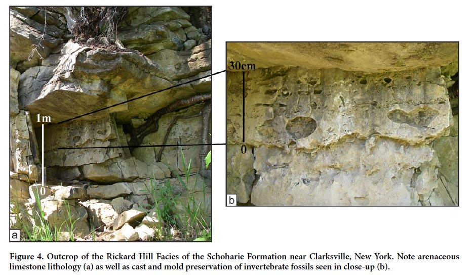 Display large image of Figure 4
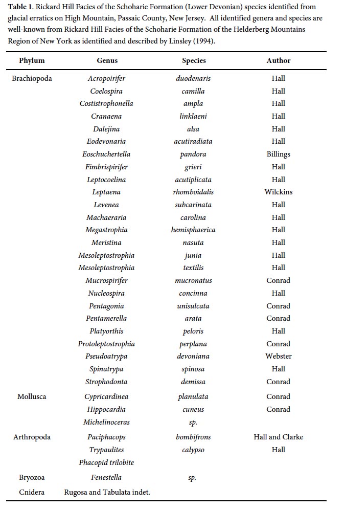 Display large image of Table 1
11 The exposures of the Rickard Hill Facies of the Schoharie Formation in Albany County, New York also display very similar weathering patterns to those seen in the erratics found on High Mountain. In support of this interpretation, two large erratics of the same lithology, fossil content and weathering as those from High Mountain, New Jersey were found south of the exposures at Clarksville, New York and in line with the proposed path of travel for the erratics (Fig. 1). The first of these erratics was recovered ~10 km south of the village of Leeds, New York, and approximately ~45 km south of the exposures at Clarksville. The second erratic was recovered along an eastern facing slope along Ramapo Reservation, New Jersey and approximately ~15 km north of High Mountain. We interpret these erratics to have been plucked from the Clarksville, New York outcrop location and deposited along the same path of north to south travel as those recovered from High Mountain. North to south oriented glacial striations mapped on the Preakness Basalt of High Mountain by Stanford (2003) reinforce our proposed path of travel.
TIMING RICKARD HILL ERRATICS FINAL DEPOSITION AND FUTURE RESEARCH
12 A number of small kettle ponds and wetlands exist just to the north of High Mountain in the town of Franklin Lakes, Bergen County, New Jersey, and an age date of formation for one of the kettle ponds places some constraints on the timing of the final deposition of the Rickard Hill Erratics reported here. Palynological analysis and radiocarbon dating of samples collected from one of these kettle ponds, Lower Lake Blauvelt, indicates that the arrival of the first trees (spruces) followed by deciduous hardwoods occurred between approximately 12 000 to 11 000 YBP (Rector 2000). The colonization of this area by hardwood forest by ~11 000 YBP indicates that the retreat of Laurentide Ice Sheet had taken place well before this time to allow the subsequent sequence of tree ecological succession. Analysis of cosmogenic-nuclide exposure ages from rock samples from gneissic boulders and quartzite and gneiss striated outcrops taken near the late-Wisconsin terminal moraine just west of High Mountain in Allamuchy and Picatinny, New Jersey (Fig. 1) by Clark et al. (1995) indicate deglaciation had taken place by 18 500 BP. This age estimate is consistent with multiple other studies timing glacial retreat in New Jersey such as Sirkin and Minard (1972), Sirkin (1977), Russell and Stanford (2000), and Stanford (2003).
13 Inevitably, all erratics deposited throughout High Mountain and the surrounding region would have been influenced by enormous amounts of meltwater channelized through the Watchung Mountains and accumulating in places such as glacial Lake Passaic. Models such as those proposed by Uchupi et al. (2001), Donnelly et al. (2005), and Rayburn et al. (2005) indicate catastrophic drainage of glacial lakes behind the terminal moraine had vast impacts on erosion and deposition of the New Jersey portion of the Hudson Shelf to the east of the Watchung Mountains. Such meltwater flow would have been easily capable of additional erosion, transportation and deposition of glacial sediments (including erratics) deposited on High Mountain. This interpretation is supported by Kelly et al. (2008) whose cosmogenic-nuclide exposure data indicate that it is not uncommon for glacial erratics to be eroded, transported and deposited multiple times by glacial ice advance and retreat as well as meltwater activity before final deposition takes place. It is unlikely that the samples of Clark et al. (1995) display much inheritance as the data from boulders and outcrop are consistent with one another and with samples they processed from other regions of the country.
14 Based on available age dating methods utilized in northern New Jersey by previous researchers and meltwater transport considerations, we conservatively suggest that the final deposition of the Rickard Hill Erratics on High Mountain occurred within a few thousand years after 18 500 YBP. This age range estimate would provide enough time for the High Mountain study area to be deglaciated, occurring sometime between the Moggy Hollow and Great Notch stages of Lake Passaic (Stanford 2007), and the ability for glacial meltwater transportation effects on the Rickard Hill Erratics to be minimized. Additional geochemical analyses, such as cosmogenic exposure age dating, of the Rickard Hill Erratics from High Mountain would be useful in further refining our age interpretation.
15 Preliminary investigation of ground moraines and tills deposited across High Mountain indicate that the Laurentide Ice Sheet was non-discriminatory in plucking, transporting and depositing known bedrock types from the Helderberg Mountains Region of New York. Abundant intrusive igneous and high grade metamorphic erratics are common throughout High Mountain, particularly in topographically lower areas dissected by the regional drainage network. Previous studies document that the principle source area for these rocks is the Hudson Highlands and areas such as Harriman State Park, New York (Witte 1998; Stone et al. 2002; Stanford 2003). An examination of ice flow paths by Stone et al. (2002) indicates the area of High Mountain as being located along the western margin of the Hackensack Lobe of the Laurentide Ice Sheet (Stanford 2007). Tying in these studies with the finding of a distinct suite of lithologies from the Lower Paleozoic section of the mid-Hudson Valley of New York State on High Mountain and additional samples of at least the Rickard Hill Erratics at the Campgaw Reserve and further points north, indicates that the up-ice source for the Hackensack Lobe likely covered over portions of the western Helderbergs/western mid-Hudson Valley. As this portion of the Laurentide Ice Sheet flowed south, its flow split to some extent around and over the resistant bedrock of the Ramapo Mountains (Fig. 1), picking up more erratics in the process and depositing the bulk of its load from this area at High Mountain.
16 Our ongoing investigation indicates that fossiliferous erratics representing other well-known Lower and Middle Devonian groups and formations from the Hudson Valley and Helderberg Mountains Region also occur on High Mountain. The distinct lithology and fossil assemblages from the Lower and Middle Devonian of the Helderberg Mountains Region, such as those belonging to the Helderberg and Hamilton Groups, have been well-documented for nearly two hundred years (Mather 1843; Linsley 1994). Accordingly, these Lower and Middle Devonian fossiliferous erratics from High Mountain provide a unique opportunity to further model the complex glacial history and surficial geology of Helderberg Mountains Region and New Jersey Piedmont.
We thank the following individuals for their contributions to this study: J. Cutuli, A. Koney, H. Maisch, A. O’Brien, and D. Pagano provided assistance with fieldwork and fossil collection. Y. LeGoff aided in the translation of the abstract. This research was supported in part by Center for Research and Assisted Release Time Grants from William Paterson University to MAB. We thank two anonymous reviewer, as well as editor D. West and C. White, for their helpful comments and suggestions which led to significant improvements in the manuscript.