Articles
Engineering properties of fine-grained estuarine sediments in the Saint John River Valley at Fredericton, New Brunswick, Canada
ABSTRACT
Fredericton, New Brunswick, is situated in an estuarine valley with its urban centre overlying up to 60 m of unconsolidated Late Wisconsinan-age glacigenic sediments. The discontinuous nature of units comprising the underlying sedimentary architecture represents challenges to engineering in the city. Major concerns have been the identification of pathways into the supply aquifer lying below the urban centre, and the sensitive nature of a buried fine-grained estuarine clay-silt unit. Results from a borehole drilled in the city centre were used to characterise the sediment units and recover samples from the estuarine unit for tests of engineering properties. Sediment descriptions, index properties and chloride content enable differentiation of the unit into zones representing mainly freshwater or marine water deposition associated with glacier melting and marine incursion during deglaciation of the Saint John River Valley. The results and inclusion of published geophysical data presented herein represent the first comprehensive study of vertical variability in engineering and sediment properties of the clay-silt unit at Fredericton.
RÉSUMÉ
La ville de Fredericton, au Nouveau-Brunswick, est située dans une vallée estuarienne et son centre-ville recouvre jusqu’à 60 m de sédiments glaciogéniques non consolidés du Wisconsinien tardif. La discontinuité des unités constituant l’architecture des sédiments sous-jacents pose de sérieux problèmes en matière d’ingénierie dans la ville. Le repérage des voies d’accès au réservoir aquifère qui se trouve sous le centre-ville et la vulnérabilité d’une unité estuarienne enfouie d’argile limoneuse à grain fin ont été des sources de grandes préoccupations. Un trou de forage pratiqué dans le centre-ville a permis de définir les caractéristiques des unités sédimentaires et de prélever des échantillons de l’unité estuarienne en vue d’en analyser les caractéristiques géotechniques. Les descriptions, les propriétés caractéristiques et la teneur en chlorures des sédiments permettent de séparer l’unité en zones qui représentent principalement des dépôts d’eau douce ou d’eau marine associés à la fonte des glaciers et à l’infiltration d’eau de mer durant la déglaciation de la vallée de la rivière Saint-Jean. Les données géophysiques déjà publiées ci-incluses et les résultats représentent la première étude exhaustive de la variabilité verticale des propriétés mécaniques et sédimentaires de l’unité d’argile limoneuse de Fredericton.
[Traduit par la redaction]
INTRODUCTION
1 In glaciated areas, the architecture of unconsolidated sediments in deep pre-glacial valleys can be very complex (Clague 1986; Spooner and Osborn 2000; Gibling 2006). Common challenges to urban development in these settings are mainly related to supply of potable groundwater from buried aquifers and the occurrence of sensitive or low-strength cohesive sediments that represent challenges for the stability of foundations (i.e., Legget 1973; Legget and Hatheway 1988).
2 A dataset and three-dimensional soſtware model has been generated for the Fredericton area from examination of 602 archived borehole records of sediment lithologies encountered during drilling within the City of Fredericton (Daigle and Broster 2006). The aim of the present study is to examine the engineering and sediment characteristics of the major stratigraphic units from analyses of samples obtained from a borehole (UNB1-03) drilled as part of a project funded by the Canadian Water Network. The geotechnical properties and complexity of the clay-silt samples from UNB 1-03 are presented here with examination of the relationship between variability of sediment characteristics and changing paleoenvironment. This study presents the first description of vertical variability in engineering properties, chloride content and sediment characterisation of clay-silt units at depth and will serve as a valuable reference for future hydrological and engineering studies within the City of Fredericton.
Location and Geology
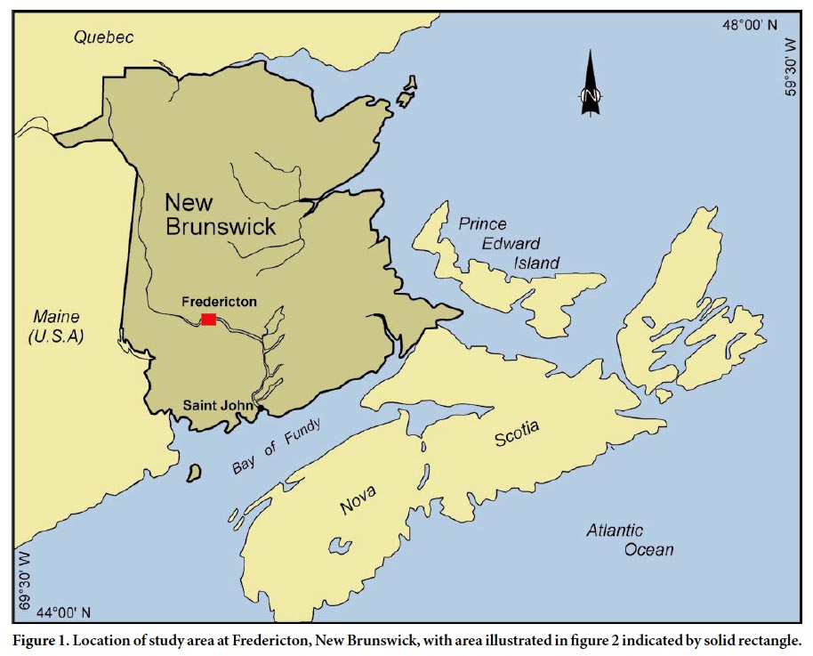
3 Fredericton is the capital city of New Brunswick with a population of about 55,000 inhabitants (Fig. 1). The Saint John River bisects the city at a location down river of the point of tidal influence that extends up-river to Mactaquac Dam (Fig. 2). At approximately 125 km upstream of its confluence with the Bay of Fundy, the elevation of the river at Fredericton averages around 2–3 m in elevation with the river bottom deepening to more than -5.5 m in places (Butler et al. 2004; Nadeau 2006). The city’s downtown urban centre is located on a wide floodplain mostly located along the south side of the river. The relief changes from the floodplain at an average of 10 m elevation to greater than 100 m in elevation at the top of the steep valley wall to the south of the river. The north side of the valley rises gradually in elevation to greater than 150 m, with relief largely controlled by the incision of small rivers locally flowing into the Saint John River (Fig. 2). The City’s urban centre overlays a deep bedrock valley that has been infilled with up to 60 m of glacial and post-glacial sediments. This ancient valley has been cut into bedrock comprised mainly of Carboniferous Pictou Group terrestrial sedimentary units, consisting of red and grey conglomerate, sandstone, siltstone, and shale (McLeod et al. 1994).
 Display large image of Figure 1
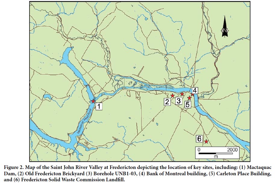 Display large image of Figure 2
4 Several authors have contributed to the present-day understanding of the unconsolidated deposits in the area (e.g., Chalmers 1884; Kiewiet de Jonge 1951; Lee 1957; Gadd 1971; Kingston and Lohse 1975; Seaman and Thibault 1981; Rampton et al. 1984). During glaciation the bedrock surfaces were scoured by glacial ice and parts of the Saint John River Valley were deepened (Rampton et al. 1984). Locally, glacial flow direction was southeasterly (Lee 1957; Gadd 1971; Kingston and Lohse 1975; Seaman and Thibault 1981; Seaman 2004) concluding with deposition of ice-contact and glaciofluvial sediments as the glacier retreated inland.
5 During, or immediately following, deglaciation a large body of water inundated the Saint John River Valley, resulting in the deposition of a thick succession of clays and silts in the study area. This water body has been termed Lake Acadia by Chalmers (1902) and interpreted as an arm of the Late Glacial De Geer Sea by Kiewiet de Jonge (1951). Lee (1957) noted varve-like laminae in the clay and silt and identified small fragments from the bottom of this unit as the outer coating (periostracum) of Yoldia arctica (Gray), a marine species tolerant of muddy and brackish water conditions as are found at the mouths of glacial streams. Lee (1957) concluded that Lake Acadia was at first an icedammed glacial lake, possibly due to a residual ice cap near Saint John (Seaman 2004), and subsequently an estuary. However, burial of the outlet for the Saint John River at the Bay of Fundy (Fig. 1) likely facilitated capture of marine water and formation of a large brackish to freshwater lake in the area, prior to opening of a new outlet and return to a full estuarine environment (Seaman et al. 1993; Dickinson 2008).
6 Clay-silt sediments exposed locally were mapped by Rampton et al. (1984) as undifferentiated marine and lacustrine sediments. Daigle and Broster (2006) noted that the clay-silt unit at Fredericton demonstrates attributes of both lacustrine deposits such as zones with distinct varve-like laminae and poorly stratified zones of low strength sediments similar to marine deposits, both of which would be expected to occur in a glacial estuary. Investigation of the clay-silt unit revealed the presence of Cochlichnus anguineus Hitchcock traces on silt partings, a species reported from postglacial lacustrine deposits (Gibbard and Dreimanis 1978). These observations indicate that the unit was deposited under conditions ranging from freshwater to brackish water, associated with variation in glacier melting and marine incursion during deglaciation of the Saint John River Valley.
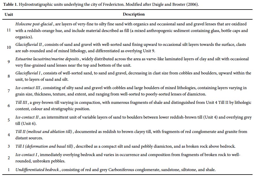
7 The stratigraphic sequence most commonly reported at Fredericton, includes: bedrock of red, grey or green sandstone and shale; till that serves as a lower aquitard; a sand and gravel unit occasionally containing cobbles and boulders or with sporadic silt and clay that serves as the main aquifer for the city (lower aquifer); a glacilacustrine/marine clay and silt unit with occasional sand lenses (middle aquitard, here informally termed the clay-silt unit); a glacifluvial sand to sand and gravel unit (upper aquifer); and a surface unit of alluvium/colluvium silty, fine-grained sand. Daigle and Broster (2006) characterized the stratigraphy as 11 hydrostratigraphic units including bedrock (Table 1). The 10 sediment units represent events from Late Wisconsinan glaciation to the present consisting of three till units, three intervening ice-contact and two glaciofluvial units, an estuarine clay and silt unit, and postglacial fluvial and modern anthroprogenic deposts.
Engineering and Environmental Studies
8 Much of the information on the subsurface units at Fredericton have been derived from geotechnical drilling mainly concerned with foundation stability due to underlying sensitive clay-silts or protection of the underlying municipal groundwater supply aquifer. One challenge to engineering projects at Fredericton has been the occurrence of thixotropic, low-strength clays at depth reported by Alkins (1983) and Landva et al. (1988). At one site in the City centre, Landva et al. (1988) noted that light construction equipment traffic on the 40 cm sand layer above the clay, “caused the clay to change to a jelly-like consistency” and flow into the open excavation trench. Geotechnical investigations at locations, short distances from the City (Fig. 2), were under taken by Watson (1970) and Munro (1994) but neither reported the occurrence of thixotropic clays.
9 Violette (1990) studied the occurrence and distribution of discontinuities in the clay and silt unit, termed “windows” by ADI Limited (1982). The windows are considered to be hydrologic pathways into the underlying supply aquifer, resulting from the thinning of clay and silt deposits above an ‘esker-like’ feature that forms the bulk of the Fredericton aquifer (Violette 1990). Violette (1990) was first to create a digital Geographic Information System (GIS) database of the Downtown Fredericton area, called GEO.DAT. This database included 107 boreholes from south side of Saint John River overlying the supply aquifer and identified six main stratigraphic units. Peters (1992, 1995) enlarged the database by examining 539 borehole logs from drilling on both sides of the Saint John River at Fredericton, but due to changes in computer and soſtware technology the raw data is no longer accessible, although lithological descriptions and stratigraphic interpretations are documented and support the earlier findings of Violette (1990).
10 As part of the current project Daigle and Broster (2006) established a GIS-referenced data base that could be used to delineate recharge pathways into the underlying supply aquifer, consisting of: (1) three-dimensional stratigraphic models of the sediment architecture underlying Fredericton, (2) geo-reference borehole data from previous studies, and (3) a data base that can be modified as new borehole information is collected. Over 1500 drill logs were collected from a variety of sources and culled to the 602 records representing boreholes within city limits that extended to depths exceeding 1.5 m, contained lithological description of the material encountered and could be accurately geo-referenced. The resulting digital data set enables better delineation of units for engineering applications and assessment and can be used to view individual logs, stratigraphic cross-sections, or in its entirety as three-dimensional block diagrams that can be rotated and magnified as desired (Daigle and Broster 2006). While providing an area view of distribution of the units, only a general description of the lithology is presented without any detailed characterisation of engineering properties or delineation of zones of low strength materials.
 Display large image of Table 1
BOREHOLE UNB 1-03
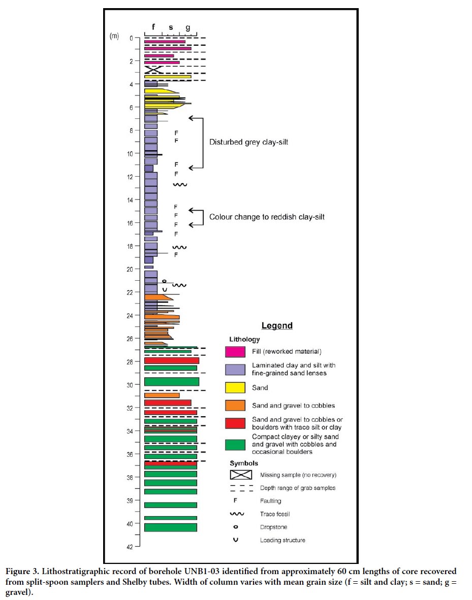
11 On June 26, 2003 borehole UNB 1-03 was drilled on the south river bank (Fig. 2) of the Saint John River to a depth of 42.67 m (140 ſt) below ground surface that transected most of the stratigraphic units identified by Daigle and Broster (2006) but did not extend to bedrock. Representing a continuous sample record, samples were collected along the full length of the borehole using 75 mm (3 in) and 50 mm (2 in) Shelby tubes and split spoon samplers for cohesive sediments. Split spoon samplers were mainly used when encountering loose unconsolidated sediment, for example from 0 to 4.2 m or 24–27 m (Fig. 3). The borehole was drilled for a separate research project with the Canadian Water Network and the core material was collected during drilling by A. Daigle for our examination and analyses.
 Display large image of Figure 3
Sample Preparation and Testing
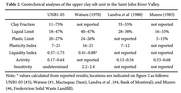
12 Samples were initially stored in PVC sample tubes and returned to the Civil Engineering Soils Laboratory at the University of New Brunswick. Core samples were split longitudinally with one half preserved for detailed sediment logging, and the other half used for geotechnical analysis. The full length of the core was laid out in the University of New Brunswick, Department of Geology Sedimentology Laboratory, allowed to dry and visually examined to produce a detailed lithological record.
13 Natural moisture contents, wet densities and penetrometer estimates of variation in unconfined compressive strengths have been measured (Daigle 2005; Nadeau 2006). A total of 29 samples of the clay-silt unit were analysed for geotechnical properties and granulometric analysis. As the clay-silt unit was of particular interest only fine-grained particle analysis was conducted as set out in ASTM D 422-63, slightly modified (Bouyoucos 1962).
14 For 28 samples from the clay-silt unit, mineralogy was determined using X-Ray Diffraction (XRD) and chloride concentrations were determined using Inductively Coupled Plasma-Optical Emission Spectrometry (ICP-OES). Samples were analysed using standard operating procedures by a Bruker D8 Advance Solid State Powder Diffraction XRD System at the University of New Brunswick.
Core Description and Interpretations
15 A log of the UNB 1-03 core was constructed based on visual observations in its dried state (Fig. 3). The lowest potion of the core (41–37 m) consists of brown matrix-supported diamict containing a mixture of subangular to subrounded clasts, varying in size and lithology, with most lithologies from distant sources. Several of the clasts were subangular, striated and coated with silt. The presence of silt coatings on the clasts and predominance of lithologies that are not local, suggests that the sediment is englacial meltout till (cf. Dreimanis, 1976). Therefore, this lowermost unit likely represents deposition from a stagnant or retreating ice-lobe and is correlated with Unit 4 (Till 2, Table 1).
16 Above 37 m poorly sorted diamict occurs in beds separated by sporadic lenses of sand and sub-angular to sub-rounded gravel with traces of silt in the lower layers, becoming mainly sand and gravel from 33–31 m. The sand and gravel layers interfinger with diamict layers and are interpreted to be ice contact sediments (Unit 5), likely deposited at or very near the ice front with minor reworking from meltwater. Improved sorting and rounding of clasts at 31–30 m may represent a significant local retreat of the ice front prior to deposition of the uppermost till.
17 A grey-brown diamict, varying in compaction with sub-angular clasts and fragments of shale, possibly of local origin, occurs from approximately 31 to 28 m and is correlated with Unit 6. At 28 m the diamict (till) is divided by 1 m layer of poorly sorted sand and sub-angular to sub-rounded gravel with traces of silt and clay. The interfingering of till and poorly sorted sand and gravel suggest a gradation to an ice-contact facies likely correlative with Unit 7. Above 27 m the sand is course-grained, gravel clasts are rounded to sub-rounded and the sediment grades upward to fine sand more characteristic of glaciofluvial (Unit 8) deposits.
18 From 26 to 24 m sand layers are interbedded with beige to brown sandy-silt that becomes clay-rich towards 22 m (unit 9). At approximately 20 m the unit changes upward to a laminated silty-clay, grey and buff in colour. Rhythmically laminated grey and buff coloured clay and silt with occasional thin lenses of fine-grained sand millimetres thick occur from a depth of approximately 20 to 6.75 m below surface. Clay content increases upward from the base to a clay-rich zone (average 70% clay) at 20 to 17.5 m (Figs. 3, 4). At a depth of 22 m, a 1–2 cm wide lens of graded sand with small angular fragments was found (Fig. 5a). Such layers may represent resedimentation due to slumping, a tempestite, or deposition from ice raſting. Faulting in the clay-silt unit was noted in several locations (Figs. 3, 5b). In core, these appeared to be small normal faults with measured displacements along the fault planes ranging from a few millimetres to a few centimetres. Samples of grey/buff laminated clay-silts collected above 12 m were easily disturbed by sampling and lab treatments. These samples (note top of samples in Fig. 4b) demonstrate deformed layering, fluid expulsion features, but no brittle faults. Some minor faults may be from disturbance during drilling and sampling; in particular, those occurring near the ends of the sample cores. Other faults occurred in undisturbed portions of the core samples (Figs. 3, 5b; 17–12 m) and it was interpreted that these faults likely pre-dated sampling as the faults were brittle, showed clear vertical displacement of laminae, and the surrounding materials where undeformed. At approximately 21 m (69 ſt) depth, a 12 by 5 mm dropstone was found in a thin (5 mm) fine-grained sand seam (Figs. 5c, d) and the first of three trace fossils was found directly beneath this coarser lamina (Fig. 3). Nematode traces identified as Cochlichnus anguineus Hitchcock by R.K. Pickerill (personal communication, 2005), were found along silt partings at depths of and 21.20, 18.14, and 12.78 m from the surface (Figs. 5e, f).
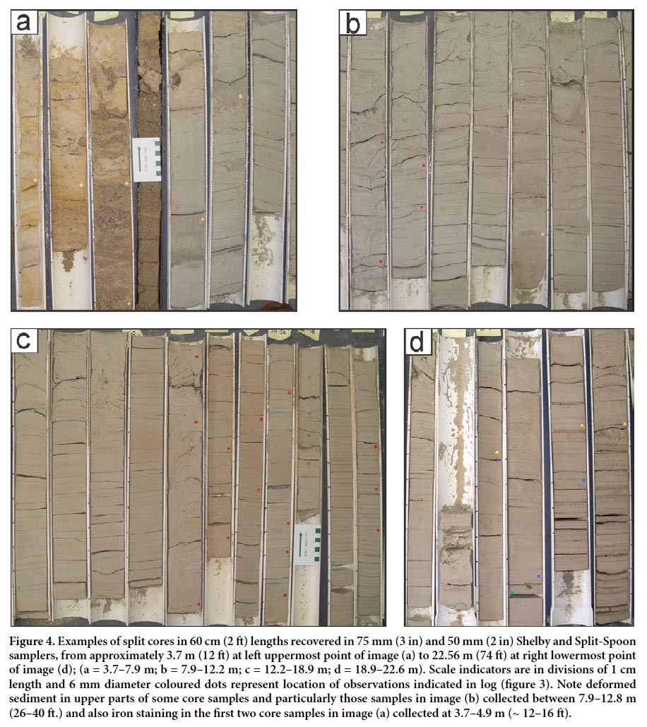 Display large image of Figure 4
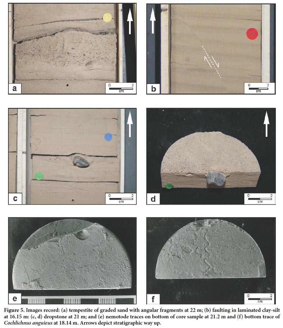 Display large image of Figure 5
19 At about 16.15 m (53 ſt) there is a marked colour variation in the laminations to a reddish-brown colour that grades to grey-buff lamina at 14.6 m (Figs. 3, 4), although intermittent groups of reddish-brown layers occur to about 13.7 m. Grey/buff laminated clay-silts occur to a depth of approximately 6 m. The sediments are highly deformed from 12.5–6 m and are intercalated with thin lenses of well-sorted fine sand, increasing in frequency upward. At 6 m sand (Unit 10) becomes coarse, pebbly sand, with interstitial silt and occasional lenses of silt, changing to layers of well sorted sand and pebbly sand above 3.8 m. The overlaying beds (Unit 11) consist of a faintly laminated oxidized orange-brown clay-silt and silt-fine sand, with sand and sub-rounded pebbles, with anthropogenic reworked material (fill) in the upper 0.5 m. The ground surface at the site of UNB 1-03 is a flat-lying floodplain at an elevation of 7.5 m adjacent to the present river. Materials described here represent depths below ground surface.
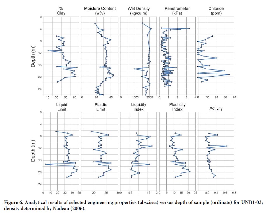
20 Grain size analysis of the clay-silt unit enables the lower 22 to 20 m (72 to 66 ſt) to be characterized as clayey-silt, grading upward into silty-clay from 20 to 14 m (66 to 46 ſt), and the upper 14 to 6 m (46 to 20 ſt) as clayey-silt. Generally there is an overall decrease in percent clay content in sediment above 17 m (Fig. 6).
 Display large image of Figure 6
21 Mineralogical analyses of the sediments in the area have been conducted by Allen and Johns (1960), Munro (1994), Giudice (2005), and Dickinson (2008). Munro (1994) reported the occurrence of a swelling clay, which was not found in UNB 1-03. Examination of UNB 1-03 revealed the clays to be predominantly clay-sized particles with few secondary clay minerals present (Giudice 2005). From the 28 samples analysed, the mineralogical composition of the clay-silt unit consisted of quartz, clinochlore, muscovite, albite, and calcite. Calcite was absent in four samples. Quartz, muscovite and calcite are common rock-forming minerals found in sedimentary rocks (Klein and Hurlbut 1993), although calcite can also precipitate from groundwater. Clinochlore is common in argillaceous sedimentary rocks such as the Carboniferous shale and sandstone units that underlie Fredericton. Albite is most commonly found in igneous and metamorphic rocks and less commonly in sedimentary rocks (Klein and Hurlbut 1993) and may be indicative of detrital contributions from glacigenic sources (i.e., till or outwash) rather than local bedrock.
22 Geochemical analyses of the clay-slit sediments have been conducted by Gudice (2005), Dickinson (2008) and Munro et al. (1997). For this study, chloride concentrations are reported for 28 samples (Fig. 6). Chloride concentrations are highest in the lower part of UNB 1-03 increasing upward from the base of the unit to a maximum of 34.5 ppm at 19.5 m. Samples above 17.5 m demonstrate an overall upward decrease in chloride ppm to a depth of 14 m (Fig. 6) coincident with the change in colour discussed earlier. At depths 13–7 m, chloride concentrations are below 10 ppm to undetectable and are similar to that reported by Munro (1994), except that in UNB1-03 values increase upward from undetectable at 8 m to 16 ppm at 6 m (Gudice 2005).
Geotechnical Properties of the Clay-Silt Unit
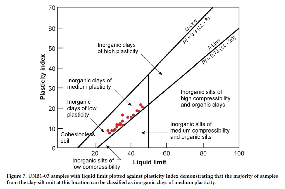
23 Plasticity characteristics of the UNB1-03 clay-silts indicate the sediments to be inorganic clays of low to medium plasticity (Figs. 6, 7). The range over which the UNB1-03 values plot is typical of illite clays (Stumpf et al. 1998), although none were found here. Skempton (1953) defined the activity of clay as the ratio of plastic index to percent clay fraction content. Clays with activities less than 0.75 are considered inactive clays, those with activities from 0.75 to 1.25 are considered normal, and those with activities greater than 1.25 are considered active (Skempton 1953). Calculated activities of clays in this study ranged from 0.17 to 0.64 (Fig. 6) and would therefore be considered inactive with medium compressibility (Fig. 7)
 Display large image of Figure 7
24 Sensitivity is defined as, “the loss of undrained strength that is observed when an undisturbed clay is remoulded” (Mitchell and Houston 1969, p. 845). The sensitivity of clays has been correlated to the liquidity index, such that clays with liquidity indexes greater than 1.0 can be transformed to a viscous state and flow like a liquid when remoulded (Das 2005). The samples analysed in this study display liquidity index ranges of 0.57 to 1.73 with the majority of the grey clay-silts above 18 m having values greater than, or approaching 1.0 (Fig. 6). These upper grey clay-silts are therefore considered to be highly sensitive, and appear to correlate to the sensitive soils reported by Landva et al. (1988) and Alkins (1983) near the Bank of Montreal site in Fredericton (site 4, Fig. 2).
25 Drilling indicates that underlying the floodplain at Fredericton, two water tables exist separated by the clay-silt unit serving as an aquitard where that unit forms an unbroken layer. An upper groundwater table is commonly found that occasionally represents a perched water table from ground water within the permeable near-surface sediments. A lower water table representing the potentiometric surface of a lower aquifer underlying the clay-silt sedments occurs where windows, gaps in the estuarine unit enabling linkage between the lower and upper water systems, are not present. The natural moisture contents of the clay-silts examined were found to increase at depth to a maximum of 42% at 19.5 m (Fig. 6). Landva et al. (1988) suggest that the high water content zone, within the clay-silt sediments, may be a result of some form of bonding developed in the clays during and aſter deposition. Another explanation could be that the increased moisture content at 7.5 and 19.5 m (Fig. 6) is a capillary fringe-effect in the clay (cf. Fetter 2001), drawing water downward from the overlying aquifer and upward from the underlying city-source aquifer (Fig. 3). The slight decrease in the density profile of UNB1-03 (Fig. 6, as determined by Nadeau 2006) is contrary to an expected increase in density with depth, but may be caused by increased moisture content in the clays.
26 Pocket penetrometer readings taken from fine-grained sediments show variable readings with depth. Sediments at 4 m depth, interlayered within the upper coarser grained sand beds, demonstrate the highest penetrometer and wet density values (Fig. 6). The high penetrometer and density readings occur in the upper layers above 6 M (20 ſt) and may be indicative of post-depositional minor cementation from precipitation of iron oxide (see Fig. 4a) or occasional subareal exposure at time of deposition. As the sediments are mostly laminated, variable results are dependent on the laminae being tested. Generally, the penetrometer readings do not demonstrate a general decrease in values with depth as was found for density or liquidity index, or general increase in values with depth as was found for percent clay, liquid limit, or plastic index.
 Display large image of Table 2
DISCUSSION AND INTERPRETATIONS
27 The geotechnical results from UNB1-03 fall within the range of values reported by previous workers (Table 2), however we attribute the variation in engineering properties to differences in depositional environment within the postglacial valley. Especially important is the proximity to melting ice sheets and variation of the basin geochemistry between fresh and brackish water conditions. Sediment deposited in the centre of the valley (i.e., Bank of Montreal, Landva et al. 1988) where the basin would have been deepest and marine influence greatest, are expected to be more sensitive than those deposited in shallower areas closer to valley sides (i.e., Fredericton Solid Waste Landfill, Munro et al. 1997) or where freshwater contribution from melting glaciers would have been greatest. In a similar fashion, clay-silts deposited at higher elevations further up tributary valleys would have had less influence from the marine incursion and likely be less sensitive.
28 At the end of glaciation, marine waters invaded much of the southern part of New Brunswick (Dickinson 2008). With isostatic rebound these areas became shallower and areas along the valley more prone to the effects of shoreline slumping and erosion by local wind and stream currents. These activities could explain the upward change at UNB1-03 from silty clay to clayey silt and eventually fluvial sands. No desiccation cracks were found that would indicate subaerial exposure. The variation in color within the core is attributed to sediment input from a new source area, more likely due to changing patterns of adjacent tributaries rather than the result of weathering.
29 Faults examined within non-deformed UNB1-03 samples were found to be mostly in zones of relatively low plasticity and locations directly above sensitive zones with high liquidity indexes. The fractures may represent periods of tensional stresses from slumping of adjacent sediments into deeper water. Faulting and occasional water escape structures may also represent shear from former distant seismic events. The sensitive behaviour exhibited by the clay samples may be related to the colloidal activity of the clay itself, an artefact of the environment of deposition, or post-depositional change in geochemistry. As documented by Mitchell and Houston (1969), the two main causes of clay sensitivity are: (1) leaching of salt water from flocculated marine clays; or (2) the introduction of dispersing chemicals from decomposing organic layers leaching into the clay. There is no evidence of a substantial amount of organic material (peat) present in or above the clay-silt unit from which the necessary dispersing chemicals could be derived, however such a deposit could have existed in the past and eroded by Holocene fluvial activity.
30 The study area is well within the limit of marine incursion up the Saint John River Valley following deglaciation and prior to isostatic upliſt (Lee 1957; Gadd 1971; Rampton et al. 1984; Seaman 2004). Therefore, the area was likely under brackish estuarine conditions as a result of the mixing of saltwater from the marine incursion with the influx of fresh meltwater from retreating glaciers. Thus, clay-sized sediments discharged into this environment during periods of decreased freshwater influx, could form a flocculated structure upon deposition. The subsequent isostatic and eustatic changes would have lead to much of the landscape rising above sea level, possibly causing leaching of the salt in the clays by freshwater and producing an unstable “card-house” type of fabric (Mitchell and Houston 1969).
31 Chloride does not commonly constitute a large percentage in the mineralogical composition of clays (Gillott 1968) nor is it oſten deposited in lacustrine lakes. Gieskes et al. (1991) note that very small but distinguishable increases in dissolved chloride can attest to past salinity changes associated with glacial periods. At Fredericton the decrease in chloride concentrations upward within the clay-silt unit are inferred to represent the input of freshwater into a brackish estuary, that due to pulses of glacial meltwater and subsequent isostatic rebound, resulted in a ponded inland sea that eventually changed to mostly lacustrine conditions across the area.
32 Nadeau et al. (2004) report geophysical data for three boreholes including UNB1-03. Of particular interest is a zone of increased P wave velocity at 14.5–16.5 m that Nadeau et al. (2004) refer to as a pervasive “mid-clay reflector” recorded at other locations across the floodplain and herein referred to as the MCR zone. This MCR zone corresponds to the change to a reddish colour and noticeable faulting within the UNB1-03 clay-silt. Beneath the MCR there are noticeable increases in percent clay, liquid limit, plasticity index, natural moisture content and a major decrease in density (Figs. 5, 7). Compressional wave velocities (Vp) also demonstrated a significant increase in values between depths of 9.5–10.5 m (Nadeau et al. 2004). The latter zone demonstrates an increase in natural moisture content with values exceeding 35 W% in samples between 7–9 m (Fig. 6). Density was not measured at this elevation and the reason for increased wave velocity remains unknown (Nadeau 2006).
33 Nadeau et al. (2004) report values for shear wave (Vs) seismic velocities of 100–300 m/s, observed for the uppermost 20–30 m of the alluvial sand and the middle clay-silt units for UNB 1-03. Amplification of ground motion would be expected at sites overlying these low shear wave velocity zones. This may have contributed to shaking in the downtown area of Fredericton that have accompanied rare distant earthquakes (Broster 1998; Broster and Burke 2011).
CONCLUSIONS
34 Vertical variability in engineering properties and characteristics of UNB1-03 clay-silt sediments are mostly due to paleoenvironments. Major environmental changes included variation in the mixing of marine and fresh water from glacier melting in a predominantly estuarine marine environment, development of lacustrine conditions, subsequent establishment of estuarine fluvial conditions and post-depositional geochemistry. Although the clay-silt unit is distinctly laminated and varve-like, it began from deposition in a brackish environment as open-water marine conditions invaded much of area. The gradual decrease in chloride content likely occurred aſter brackish water became ponded by isostatic rebound, closing previous outlets to the ocean and forming an inland sea that slowly changed to a freshwater lake. Towards the end of this de-glacial lacustrine phase, drainage outlets were re-opened or new ones found. During a change from a lacustrine to a predominantly estuarine fluvial environment, the Saint John River Valley locally, was re-opened to marine influences resulting in increased chloride concentrations. The Fredericton area likely remained under a brackish water environment until isostatic adjustment and drainage volumes were sufficient to minimize marine encroachment and establish present conditions. Holocene fluvial activity was accompanied by re-vegetation of the area and alteration of groundwater flow and near-surface geochemistry.
Funding for this project was provided in part by the New Brunswick Department of Environment and Local Government (Sciences and Reporting Branch). Funding for the drill hole UNB1-03 was provided by the Canadian Water Network through a separate research project led by Dr. T. Al, K. Butler (UNB Earth Sciences) and Dr. K. MacQuarrie (UNB Civil Engineering). Thanks to Dr. R. Pickerill for providing trace fossil identifications. The work formed part of UNB MSc theses by A. Daigle and G.M. (née Giudice) Burtt. The manuscript has benefited from reviews provided by Simon Haslett and an anonymous reviewer.