Articles
Alleghanian deformation of Cambrian metasedimentary rocks on Avalonia in south-central Rhode Island, USA
ABSTRACT
Lower greenschist-facies metasedimentary rocks of the Middle Cambrian Conanicut Group occur in and around Beavertail State Park, Rhode Island. Detailed structural mapping (1:1000-scale) and petrology of these rocks indicate an early fold generation (F1) and axial planar metamorphic foliation (S1). F1 is folded by a more prominent, E-verging, NNE- to NNW-trending, non-coaxial fold generation (F2) and an associated pressure solution-enhanced crenulation cleavage (S2). A third map-scale fold generation is inferred from NNE-trending broad folding of F2 and S2. N-S extension resulted in boudins that deformed S2 on a scale of 1–10 m, whereas late planar quartz veins indicate NW-SE extension. All structures are cross cut by faults striking N- to NE- and ENE-to ESE that show dominantly normal motion with minor sinistral or dextral components. Kink bands associated with faulting trend NNE to ENE with WNW to NNW side up. The vertical Beaverhead shear zone juxtaposes the Cambrian rocks with Pennsylvanian rocks of the Narragansett Basin, and deflects S2 in a dextral sense, consistent with motion recorded elsewhere.
The Cambrian rocks record the same deformation and metamorphism as the adjacent Narragansett Basin rocks. No evidence was found for pre-Alleghanian deformation or for northwest- or north-directed thrusting and accretion of a Meguma-like terrane during the Alleghanian orogeny. If the Beaverhead shear zone was a preexisting terrane boundary within Avalonia, both the Cambrian and Pennsylvanian Narragansett Basin sediments were deposited after terrane accretion.
RÉSUMÉ
Des roches profondes métasédimentaires du faciès des schistes verts, que l’on retrouve dans le groupe Conanicut du Cambrien moyen, sont présentes dans le Beavertail State Park, au Rhode Island, et dans les environs. Une cartographie structurale détaillée (à l’échelle 1:1 000) et la pétrologie de ces roches indiquent la formation précoce d’un pli (F1) et une foliation métamorphique (S1) de plan axial. Le F1 est causé par la formation d’un pli (F2) non coaxial plus dominant, à vergence est et d’orientation NNE-NNO ainsi que par une schistosité de crénulation (S2) amplifiée en raison d’une dissolution par pression connexe. La formation d’un troisième pli à l’échelle cartographique est provoquée par un vaste plissement du F2 et de la S2 d’orientation NNE. Une extension N-S a produit des boudins qui déforment la S2 sur l’échelle de 1 à 10 m, tandis que des veines de quartz planes formées ultérieurement indiquent une extension NO-SE. Toutes les structures sont traversées par des failles orientées N-NE et ENE-ESE montrant un mouvement normal dominant accompagné de composantes senestres et dextres peu importantes. Les bandes froissées associées à ces failles sont orientées NNE-ENE et présentent une tangente verticale ONO-NNO. Dans la zone de cisaillement verticale de Beaverhead, les roches du Cambrien sont juxtaposées aux roches de la Pennsylvanie du bassin Narragansett, et la S2 dévie en un mouvement dextre, ce qui concorde avec le mouvement enregistré ailleurs.
Les roches du Cambrien montrent la même déformation et le même métamorphisme que les roches du bassin Narragansett adjacent. On n’a trouvé aucune donnée appuyant la création d’une déformation avant l’orogenèse alléghanienne ni celle d’un chevauchement et d’une accrétion orientés vers le nord ou le nordouest d’un terrane semblable à la zone de Meguma lors de l’orogenèse alléghanienne. Si la zone de cisaillement verticale de Beaverhead constituait une limite de terrane qui existait avant l’orogenèse de l’Avalonien, les sédiments cambriens et pennsylvaniens du bassin Narragansett se sont déposés après l’accrétion du terrane.
[Traduit par la redaction]
INTRODUCTION
1 New England is composed of tectonic blocks, microcontinents, and/or terranes accreted to eastern Laurentia primarily during the Silurian-Devonian Salinic, Acadian, and Neoacadian orogenies, and the Pennsylvanian-Permian Alleghanian orogeny (O’Hara and Gromet 1985; Goldstein 1989; Skehan and Rast 1990; Wintsch et al. 1992, 2007; Rast and Skehan 1993; Hepburn et al. 1995; van Staal 2005; Hibbard et al. 2006, 2007). Over the last three decades, the number and extent of these terranes and the timing of their accretion and juxtaposition have been debated. To constrain plate tectonic reconstructions of Laurentia and accreted peri-Gondwanan blocks it is necessary to thoroughly understand the deformational histories of these terranes.
2 Field, geochronological, geochemical, and geophysical investigations have addressed the timing of accretion of both Avalonia and Meguma, the two most outboard peri-Gondwanan blocks, to eastern Laurentia (e.g., Keppie and Dallmeyer 1987, 1994; Hutchison et al. 1988; Keen et al. 1991; Waldron et al. 1996; Hibbard et al. 2007). Avalonia extends north from Rhode Island, USA, into eastern Canada (southeastern New Brunswick, northwestern Nova Scotia, and eastern Newfoundland) whereas the outboard Meguma terrane is juxtaposed to Avalonia along the Minas fault zone in Nova Scotia and inferred extensions in offshore areas (Fig. 1a) (Hutchinson et al. 1988; Keen et al. 1991; Murphy et al. 2011).
 Display large image of Figure 1
3 The mainly Neoproterozoic sedimentary, volcanic, and plutonic rocks and overlying Cambrian-Ordovician sedimentary rocks of Avalonia experienced a period of tectonic quiescence until a tectonothermal event in the Silurian-Devonian, evidence for which is preserved in rocks in parts of Avalonia in New Brunswick and northern mainland Nova Scotia (e.g., Nance and Dallmeyer 1994; Waldron et al. 1996). Although the precise timing of accretion of Avalonia to composite Laurentia is still debated, it has been postulated to have been accomplished by the Early Devonian (e.g., van Staal and Barr 2012).
4 The Meguma terrane is composed of stratified Paleozoic rocks that overlie unknown continental basement material. It accreted to eastern North America during the mid-Devonian Neoacadian orogeny, with further juxtaposition during the Alleghenian (Waldron et al. 2009, 2011; Murphy et al. 2011; White and Barr 2012; White et al. 2012).
5 One area of Avalonia that remains poorly understood is the part of the southeastern New England (SENE) Avalon (Thompson et al. 2010, 2012) on which the Pennsylvanian Narragansett Basin lies. The SENE Avalon block is separated from the Putnam-Nashoba terrane to the west by the Bloody Bluff, Lake Char, and Honey Hill fault zones (Fig. 1b) (Goldstein 1989; Hepburn et al. 1995). It is a composite terrane structurally subdivided into the penetratively deformed Hope Valley terrane and the less deformed Esmond-Dedham terrane, separated by the inferred Pennsylvanian Hope Valley shear zone in western Rhode Island (Fig. 1b) (O’Hara and Gromet 1985; Goldstein 1986, 1989; Skehan and Rast 1990; Gromet 1991; Walsh et al. 2011). Rast and Skehan (1990) further subdivided the Esmond-Dedham terrane and defined a ‘Bulgarmarsh terrane’ located southeast of the Narragansett Basin and separated from the basin by the Beaverhead shear zone (Fig. 1b). Skehan and Rast (1990) correlated the Cambrian Conanicut Group rocks of the Bulgarmarsh terrane with dark phyllite of the Cambrian-Ordovician Halifax Formation (now Group; White et al. 2012) of the Meguma terrane in Nova Scotia. Skehan and Rast (1990) suggested that the Bulgarmarsh terrane may have been thrust northwestward over the Pennsylvanian Narragansett Basin along the Beaverhead shear zone during the Alleghenian orogeny. However, based on its fossil assemblages, Landing (1996) correlated the Conanicut Group with lower to upper Cambrian stratigraphic units characteristic of Avalonia and discounted the existence of a separate Bulgarmarsh terrane.
6 In order to determine the structural relationships between these proposed terranes, their timing of accretion and juxtaposition, and their possible correlation with distal terranes, a better understanding of the deformational history of the basement blocks within the SENE Avalon terrane is fundamental. Toward this goal, we present the results of detailed structural mapping and fabric analysis of trilobite-bearing Middle Cambrian rocks in Beavertail State Park and along the western coastline between Beavertail and Fort Getty state parks in Rhode Island (Fig. 1c). These rocks form part of the hypothesized Bulgarmarsh terrane, immediately southeast of the proposed boundary with the Esmond-Dedham terrane (Skehan et al. 1978, 1981; Skehan and Rast 1990; Landing 1996; Geyer and Landing 2001). At this important locality, the well-layered Cambrian rocks lie adjacent to Pennsylvanian strata of the Narragansett Basin along the Beaverhead shear zone (Fig. 1c). The Pennsylvanian rocks exclusively record the Alleghanian orogeny.
7 We compare the timing of deformation and metamorphism, as well as structural relationships, between the Cambrian and Pennsylvanian rocks. If earlier structures are preserved in the Cambrian rocks, it would suggest that Avalonia had accreted to Laurentia prior to the Alleghanian orogeny, and may record Acadian (or earlier) deformation. However, if the structural and metamorphic styles in the Cambrian rocks are similar to those in the Pennsylvanian rocks, it is likely that both experienced the same deformational event (i.e. the Alleghenian orogeny). Additionally, if NW-directed thrusting of the proposed Bulgarmarsh terrane is responsible for deformation in both Cambrian and Pennsylvanian rocks, then NW-verging folds and thrust faults would be expected in these rocks. The results of this study allow us to test previously proposed models for accretion and/or juxtaposition of the proposed Bulgarmarsh terrane and its relationship to Meguma terrane (Skehan and Rast 1990; Rast and Skehan 1990), as well as help constrain the timing of deformation and accretion of Avalonia to composite Laurentia.
GEOLOGICAL SETTING
8 The Pennsylvanian Narragansett Basin, located on the Esmond-Dedham terrane (Fig. 1b), was deformed during the Alleghanian orogeny (e.g., Mosher 1983; Snoke and Mosher 1989). In contrast, Neoproterozoic and early Paleozoic rocks surrounding the basin show variable deformation ranging from Neoproterozoic to Permian (e.g., Skehan et al. 1981; Hermes and Zartman 1985, 1992; Dreier 1985; Goldstein 1986; Getty and Gromet 1988; Murray et al. 1990).
Neoproterozoic (Avalonian) basement rocks
9 Surrounding the Narragansett Basin are basement rocks that show varying effects of Alleghanian and/or older deformation. Adjacent to the northwestern part of the Narragansett Basin, the Neoproterozoic Blackstone Group (Fig. 1b) was deformed and metamorphosed syn-tectonically with the intrusion of the 599 ± 2 Ma Esmond Plutonic Suite (Thompson et al. 2010), indicating Neoproterozoic tectonism (Dreier 1985). The Blackstone Group also shows younger deformation and associated metamorphism that affected the ~370 Ma Rhode Island Quincy Granite (Hermes and Zartman 1985), indicating Alleghanian tectonism (Dreier 1985). Alleghanian structures recorded in rocks of the Blackstone Group include NNE-trending folds with axial planar biotite-grade foliation and superimposed ENE-trending folds and crenulations (Dreier 1985). Further west of the Narragansett Basin, the Devonian Scituate Granite (Fig. 1b), which intruded the Esmond-Dedham terrane, is deformed only at its western margin along the proposed Hope Valley shear zone (Goldstein 1986; Getty and Gromet 1988).
10 East of the Narragansett Basin in the area of New Bedford, MA (Fig. 1b), Murray et al. (1990) documented penetratively deformed rocks that are lithologically similar to Hope Valley terrane rocks, and suggested that Hope Valley terrane may also be exposed east of the Narragansett Basin in that area. If so, the Esmond-Dedham terrane on which the Narragansett Basin was deposited would be a thrust slice. However, Hermes and Zartman (1992) concluded that most of the deformation in this area is Neoproterozoic.
11 South of the Narragansett Basin, Neoproterozoic metasedimentary rocks that crop out on Newport Neck (Fig. 1b) show several phases of Neoproterozoic and some possibly younger deformation (Skehan and Rast 1990). The Price Neck Formation records two generations of ENE-trending folds (Skehan and Rast 1990), which are Neoproterozoic based on the relationship to the 595 ± 12 Ma Cliff Walk Granite (Smith 1978). Within the adjacent Proterozoic Newport Neck Formation, NW- to N-trending, tight to isoclinal, west-verging F1 folds with slaty S1 cleavage have been refolded by N-trending F2 folds with an associated dominant S2 cleavage and N-trending broad upright F3. The age of these structures has been interpreted as either Neoproterozoic (Skehan et al. 1981) or post-Cambrian (Skehan and Rast 1990). The latter interpretation is based on the observation that the Cambrian rocks were overthrust by the Neoproterozoic rocks prior to F2; however, Webster et al. (1986) and Landing (1996) interpreted the boundary as an overturned unconformity rather than a thrust.
Cambrian rocks
12 In previous work on the Cambrian rocks in Beavertail State Park, three formations were recognized in the Conanicut Group, from oldest to youngest, the Jamestown, Fort Burnside and Dutch Island Harbor formations (Skehan et al. 1981; Skehan and Rast 1990). The Jamestown Formation contains the Beavertail Point, Hull Cove, and Lionhead members, and the Fort Burnside Formation contains the Short Point and Taylor Point members; no members were recognized in the Dutch Island Harbor Formation. Earlier workers considered these rocks to be of Pennsylvanian age (e.g., Nichols 1956; Quinn 1971), until the discovery of Middle Cambrian trilobites of Acado-Baltic affinities in the basal Jamestown Formation (Skehan et al. 1978). Dikes in the area were described by Nichols (1956) as lamprophyre (see also Skehan and Rast 1990).
13 Previous field research by Murray and Skehan (1979) recognized NE-trending, tight to isoclinal F1 folds with axial planar, slaty cleavage refolded by NNE-trending, open and overturned F2 folds. A dominant, W-dipping S2 axial planar cleavage transects F1 folds. Murray and Skehan (1979) also postulated later NE-trending F3 folds, and describe a NW-trending mineral lineation on S2 and kink bands. Skehan et al. (1981), however, interpreted the earliest folds and numerous “tectonic slides” as soft sediment slump-related structures. Skehan and Rast (1990) repeated this interpretation and further proposed that thrust faults with eastward transport occur on west-dipping S2 cleavage planes that offset upright F1 folds and likely caused the folding and boudinage of quartz veins. Most authors (e.g., Murray and Skehan 1979; Burks 1981; Skehan and Rast 1990) attributed all but the first generation structures to the Alleghanian orogeny. Skehan and Rast (1990) suggested that the Cambrian rocks were thrust northwestward over the Pennsylvanian rocks along the BHSZ during D1 and that NW- to N-directed thrusting was responsible for the deformation of both the Cambrian rocks and Pennsylvanian rocks of the Narragansett Basin.
Narragansett Basin
14 The southern part of the Pennsylvanian Narragansett Basin (southern Rhode Island) shows multiple phases of deformation and Barrovian-type metamorphism that ranges in grade from sillimanite in the west to chlorite and biotite in the east (Mosher 1983). The metasedimentary rocks of the northern part of the basin (northern Rhode Island and Massachusetts) and adjacent Norfolk Basin (Massachusetts) are at a lower metamorphic grade and less intensely deformed with upright, open, ENE-trending folds that parallel the northern basin margins (Quinn and Oliver 1962; Lyons et al. 1976; Cazier 1987).
15 In the southern part of the basin, the first phase of deformation (D1) formed open to isoclinal F1 folds and an axial planar fabric (S1). F1 folds generally trend NNE (to N) and verge westward; associated NNE-striking thrusts show westward transport (Mosher 1983, 1987). Rocks deformed at high metamorphic grades preserve two distinct fold generations, F1a and F1b, and axial planar foliations, S1a and S1b, respectively (Henderson and Mosher 1983; Reck and Mosher 1988; Snoke and Mosher 1989; Mahler-Cogswell and Mosher 1994). S1A and S1B are penetrative foliations observed across the basin. At high metamorphic grades the foliations are defined by parallel muscovite, biotite, and elongate, ductilely deformed quartz (Mahler-Cogswell and Mosher 1994) and at low metamorphic grades by pressure-solution cleavage with fine-grained, parallel muscovite and chlorite and elongate pressure-solved quartz (Farrens 1982). The second phase of deformation (D2) formed open to tight F2 folds of bedding, S1A and 1B, and an axial planar S2 crenulation cleavage enhanced by pressure solution. F2 folds trend NNW to NNE and verge eastward (Farrens 1982; Mosher 1983). Peak metamorphism occurred after D1, and generally prior to D2 (Mosher 1983; Snoke and Mosher 1989).
16 D3 and D4 are primarily developed in the NE-trending, vertical Beaverhead shear zone (BHSZ) (Mosher 1983; Mosher and Berryhill 1991; Burks and Mosher 1996), although the effects are also more broadly distributed in the high-grade metamorphic rocks (Reck and Mosher 1988; Mahler-Cogswell and Mosher 1994). Within the zone, NNE-trending sinistral strike-, oblique-, and dip-slip shear zones and faults are related to D3. F3 folds generally trend NE to E, and an associated S3 foliation was observed only at the highest grades (Mosher 1983; Mosher and Berryhill 1991; Mahler-Cogswell and Mosher 1994). During D3, clockwise-younging superposed crenulations and mesoscopic folds formed in discrete zones (Mosher 1983; Mosher and Berryhill 1991; Burks and Mosher 1996). Kink bands displaying normal motion are spatially related to faults striking N to NNE, and are overprinted by D4 structures (Mosher and Berryhill 1991).
17 Dextral NE-striking strike-slip and ENE-striking oblique- and dip-slip shear zones and faults are related to D4. During D4, pre-existing fabrics and structures are rotated into the BHSZ, and superposed anti-clockwise-younging crenulations and mesoscopic folds formed within the BHSZ and overprint D3 structures (Mosher 1983; Mosher and Berryhill 1991; Burks and Mosher 1996). At the highest metamorphic grades, N- to NE-trending open F4 folds were observed to reorient S2 and F3 folds (Reck and Mosher 1988; Mahler-Cogswell and Mosher 1994). Kink bands spatially related to E- to ESE-trending faults show normal motion (Mosher and Berryhill 1991). All across the southern part of the basin, centimetre- to decametre-scale boudins record N-S extension late during D4. This boudinage likely formed synchronously with the ENE-striking dip-slip fault motion (Farrens 1982; Mosher 1983; Mosher and Berryhill 1991). Additionally, NNW- to NNE-striking normal faults related to D3 and D4, or to Triassic rifting, juxtapose rocks of different metamorphic grades (Mosher 1983).
RESULTS
18 Based on the present study, Cambrian rocks along the coasts in Beavertail State Park and along the western coastline between Beavertail and Fort Getty state parks (Fig. 1c) are interpreted to have undergone an early contractional stage of deformation that involved three phases of folding (F1, F2, and F3), and the formation of two penetrative fabrics (S1 and S2). Later deformation produced boudins, kink bands, crenulations, fractures, and faults. Our results are based on detailed mapping at a scale of 1:1000 (Figs. 1c, 2) which included both coastlines from the southern tip of the island to Hull Cove, 2.5 km north along the eastern coastline, and to Fort Getty State Park, 4 km north along the western coastline, as well as the examination of 45 oriented thin sections.
S0 and F1/S1 structures
19 On a map scale, bedding locally changes dip over 10–20 m and forms upright folds and monoclines that are transected by S2 (Figs. 2, 3). Because these folds and monoclines were not observed to fold S2, they are interpreted to be the earliest fold phase (F1). Map-scale F1 folds and monoclines deform bedding on a wavelength of 3–15 m and amplitude of 1–2 m; some axial planes dip moderately to the east. F1 interlimb angles range from open to isoclinal as a result of refolding by the later F2 fold phase. The range of F1 inter-limb fold angles (0–90°) is locally dependent on the relative size and position of individual F1 and F2 fold hinges and limbs.
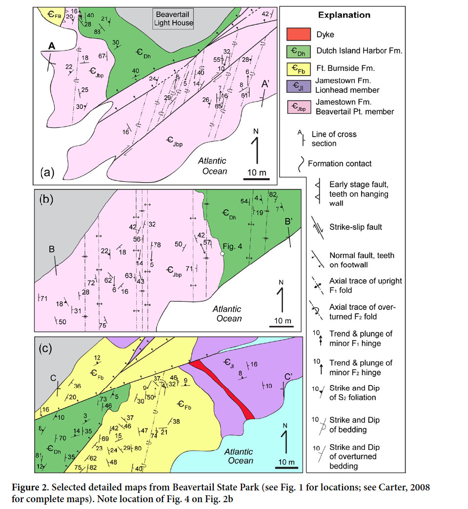 Display large image of Figure 2
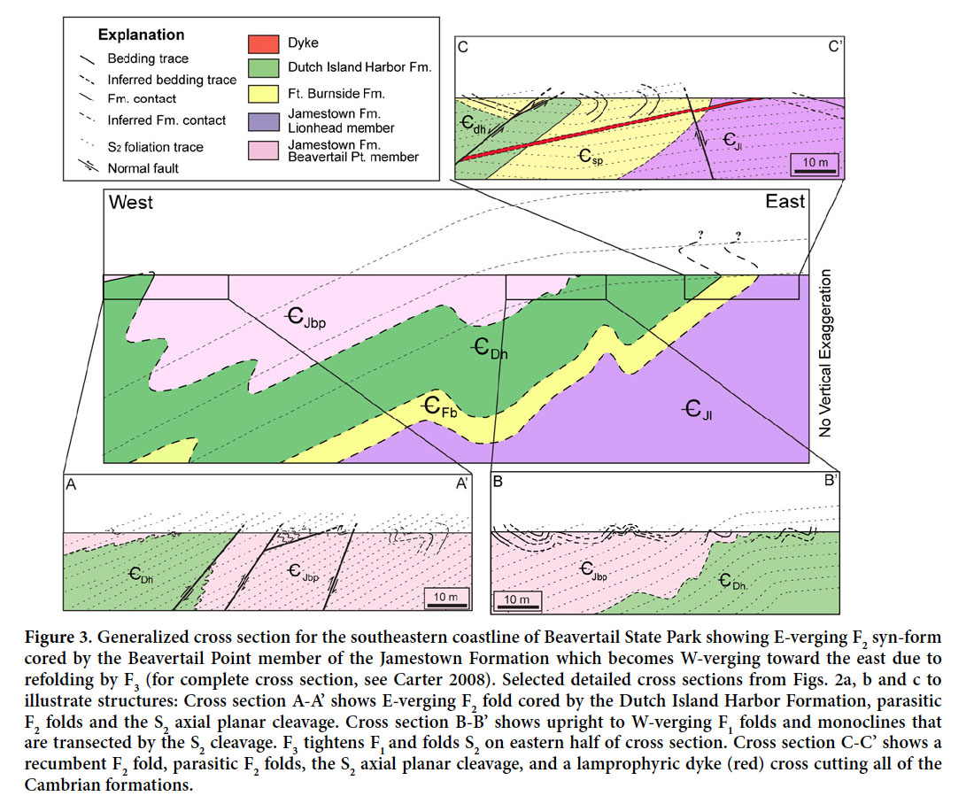 Display large image of Figure 3
20 In outcrop, the first fold generation (F1) consists of symmetrical and asymmetrical folds that deform bedding (S0). F1 folds are typically observed on S2 surfaces that transect S1 axial surfaces and F1 hinge lines, suggesting that F1 is non-coaxial with F2 (Figs. 4–6). Common wavelengths and amplitudes for F1 folds in outcrop range from 5–15 cm. F1 folds were not observed in the Lionhead or Hull Cove members of the Jamestown Formation, but were observed in all other stratigraphic units. In the Beavertail Point member of the Jamestown Formation and the Fort Burnside Formation, F1 folds are open to isoclinal. In these stratigraphic units, quartzite layers form parallel folds, but in mica-rich layers the hinges of F1 folds have thickened (Fig. 5). F1 folds in the Dutch Island Harbor Formation are cylindrical with tight to locally open inter-limb angles (Figs. 3, 6). Few F1 axes were measured because most were visible only on S2 foliation surfaces. However, F1 axes that could be measured have steep to shallow plunges and generally fall on a very broad N-S girdle (Fig. 7a). In addition, measured axial planes associated with F1 are typically upright and strike N-S. Poles to F1 axial planes fall on a diffuse E-W girdle (Fig. 7a) and define a SSE-trending fold axis, consistent with F2 fold axes.
 Display large image of Figure 4
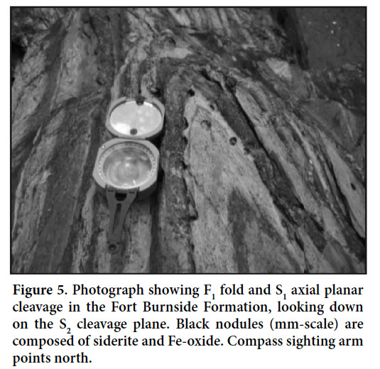 Display large image of Figure 5
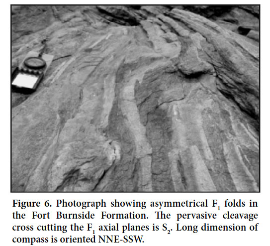 Display large image of Figure 6
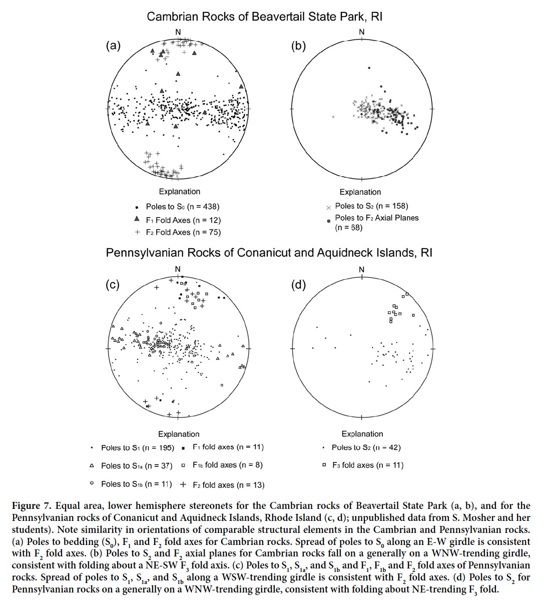 Display large image of Figure 7
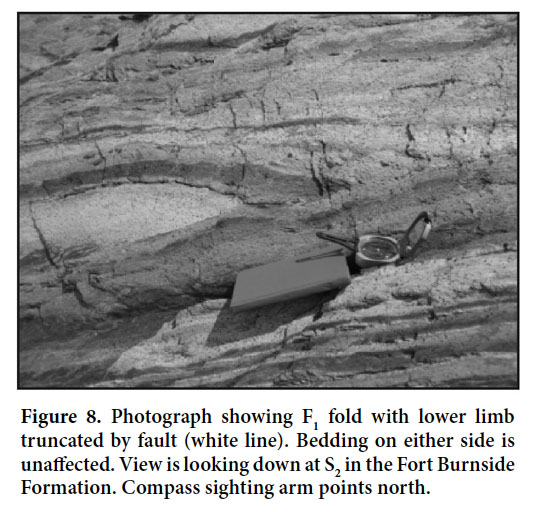
21 Early faults developed synchronously with F1, as indicated by the observation on an S2 surface of centimetre to decimetre offset along one limb of an F1 fold (Fig. 8). Additionally, early faults complicate stratigraphic relationships by juxtaposing formations in the wrong stratigraphic order. Bedding is truncated across the early faults that disrupt the stratigraphy, confirming that they are faults, not stratigraphic contacts (Fig. 9). For example, folded bedding planes of the Short Point member are truncated by an early-stage fault and juxtaposed with the Beavertail Point member (Fig. 9). These faults are folded by F2, but not F1 and are interpreted as syn-F1 faults; similar to the intraformational faults observed on S2 surfaces. No thrust faults are observed on S2 cleavage planes, and all disruption of F1 folds is attributed to syn-F1 faults.
 Display large image of Figure 8
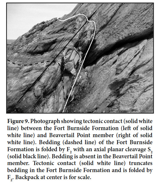 Display large image of Figure 9
22 The S1 fabric forms a continuous cleavage defined by the alignment of platy minerals. S1 is axial planar to F1 folds and is poorly developed in outcrop except within and near F1 fold hinges of mica-rich layers (Fig. 5). It is rarely present in quartzite layers. Locally, S1 is better developed than S2, but only within mica-rich layers of the Beavertail Point member and Dutch Island Harbor Formation.
23 In thin section, compositional layering (S0) is typically recognizable as light layers, composed of quartz and carbonate, with minor amounts of fine muscovite alternating with dark layers made up of fine muscovite and lesser quartz (Fig. 10). Both layers contain chlorite, and siliceous and/or siderite nodules. Pyrite crystals are most abundant in the Dutch Island Harbor Formation, and less abundant in other formations. Graphite is more abundant in darker mica-rich layers, but is also present in lighter layers. Features interpreted to be microstylolites are locally present sub-parallel to S0, but could also be crenulated graphite layers.
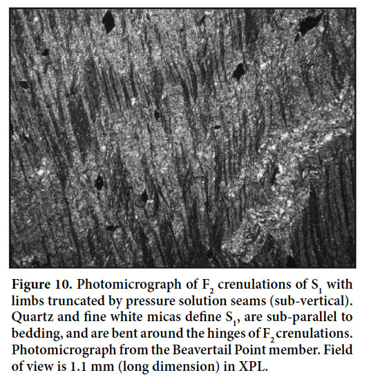 Display large image of Figure 10
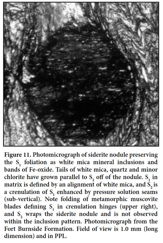
24 S1 is a penetrative metamorphic fabric in thin section, defined principally by a very well-developed alignment of fine muscovite. Some larger blades of muscovite and minor amounts of chlorite also define this fabric (Fig. 10). Where present, S1 is generally sub-parallel to bedding except in the hinges of F1 folds. S1 is also preserved as mineral inclusions in siderite and siliceous nodules that overgrew S1 (Fig. 11). In siderite nodules, S1 is defined by aligned inclusions of pyrite, white mica, rare chlorite, and elongate quartz. In siliceous nodules, S1 is defined by aligned inclusions of mostly elongate quartz, minor fine muscovite, and rare chlorite (Fig. 12). S1 is everywhere evident in mica-rich layers, but S1 is typically not well developed in quartz-rich layers where it is defined by rare muscovite grains.
 Display large image of Figure 11
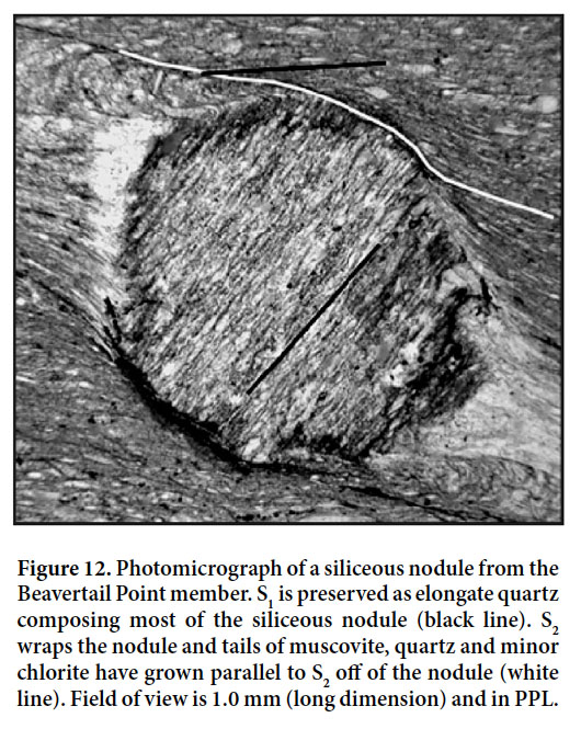 Display large image of Figure 12
F2/S2 structures
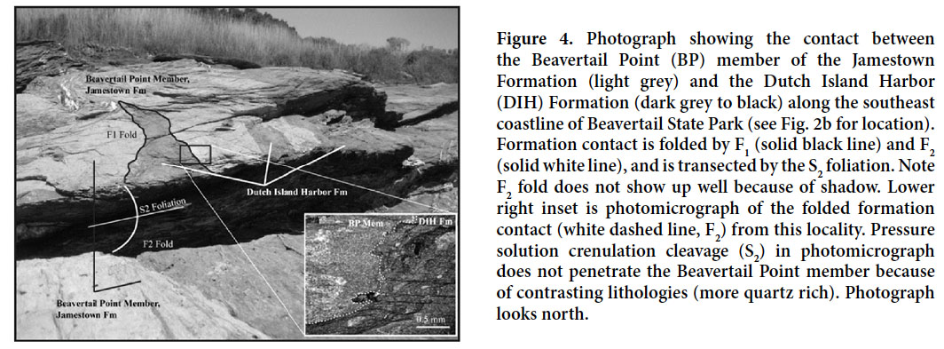
25 The dominant fold generation, F2, deforms bedding into E-verging, overturned, and locally recumbent folds. Associated with F2 is an axial planar cleavage (S2), which is commonly the most pervasive fabric in outcrop (Figs. 9, 13). F2 folds bedding, F1, S1, and the early faults that truncate F1 fold limbs and disrupt the stratigraphic order. F2 folds are typically asymmetrical with inter-limb angles ranging from open to tight. Centimetre to decimetre-scale F2 folds are commonly parasitic to metre-scale F2 folds and have wavelengths of 0.5 cm to 5 m with amplitudes ranging from 0.5 cm to 5 m. F2 fold axes trend NNE to NNW and plunge shallowly (0–10°) north and south (Fig. 7a). Many F2 folds have periclinal fold axes that split or die out along the hinge line and are doubly plunging, which most likely causes the variable plunge of F2 fold axes (Fig. 7a). Bedding poles fall on a broad E-W girdle, consistent with F2 fold axes orientations (Fig. 7a). In general, F2 folds have a similar trend as F1 folds, but are typically non-coaxial because of the generally steeper plunge of F1 folds (Fig. 7a). In outcrop, interference patterns of F1 and F2 are rare, but where present confirm non-coaxial fold generations as a result of a difference in plunge (Fig. 4).
 Display large image of Figure 13
26 In two localities along the southeastern coastline of the field area, the Beavertail Point member of the Jamestown Formation is in contact with the Dutch Island Harbor Formation and folded by F1 and F2 (Figs. 2, 4). Skehan et al. (1981) interpreted this contact as an early fault associated with F1 on the basis of their stratigraphic interpretation (Beavertail Point member as the oldest unit and the Dutch Island Harbor formation as the youngest unit). However, in our field and petrographic observations we found no evidence of brecciation along this boundary or any other evidence of faulting (Fig. 4). Thus we interpret it as a stratigraphic contact between the Dutch Island Harbor Formation and the Beavertail Point member of the Jamestown Formation. With this interpretation, we suggest that the major structure cropping out along the southeast coastline of the field area is a synformal, E-vergent F2 fold cored by the Beavertail Point member (Fig. 3).
27 In addition to folds of bedding, S2 is axial planar to folds of two different styles of quartz veins, indicating that the veins were emplaced prior to, and later folded by, F2 folds. En échelon quartz-filled extension fractures are deformed into tight to isoclinal folds. Such veins are typically 1–3 cm in thickness, and when unfolded range in length from 0.5–2 m. Other quartz veins folded by F2 were likely planar structures first before being folded by F2. Such veins are typical where S2 is shallowly dipping and are recumbently folded, with inter-limb angles that are closed to isoclinal. These folds have wavelengths varying from 1 cm up to 3 m, amplitudes ranging from 1 cm to 4 m, and vein thicknesses of 1–4 cm.
28 The penetrative S2 cleavage is present across the entire field site (Fig. 1c). In outcrop, S2 forms a smooth, continuous pressure solution cleavage (e.g., Figs. 9, 13). This cleavage is axial planar to F2 and transects F1 axial planes (Figs. 3–6), verifying that it formed after F1. S2 generally strikes NNE and is shallowly to moderately west dipping (Fig. 7b).
29 In thin section, the S2 fabric is a crenulation cleavage of S1 enhanced by pressure solution and microstylolites. Within mica-rich layers, S2 forms tight to isoclinal crenulations of S1 that are parasitic to mm-scale folds of S0 and S1 (Fig. 10). Seams of hematite and graphite are parallel to and truncate limbs of the crenulations (Fig. 10). Pervasive pressure solution along the crenulation limbs has resulted in a decrease of the inter-limb angle from that observed in outcrop. On the limbs of mm-scale folds, parasitic folds of S1 are asymmetric, whereas in the hinge they are symmetric. Wavelengths for these folds range from 0.08 mm to 0.5 mm, with amplitudes between 0.1 mm to 0.5 mm. S2 is better developed in mica-rich layers than quartz-rich layers, where S2 is best observed as microstylolites. In mica-rich layers, blades of white mica bend around fold hinges, but in quartz-rich layers individual white mica and muscovite grains have been recrystallized in fold hinges. The very close spacing of S2 indicates why S2 is commonly more pervasive than S1 at the outcrop scale (Fig. 10).
30 The S2 fabric wraps around the siderite and siliceous nodules (Figs. 11, 12), and pressure shadows composed of mostly muscovite, elongate quartz, and calcite with minor amounts of chlorite and rare clinozoisite have grown off of them parallel to S2 (Fig. 12). Clusters of pyrite crystals that grew prior to S2 also have pressure shadows composed primarily of mica, quartz, and iron carbonate aligned parallel to S2.
F3 and Sc structures
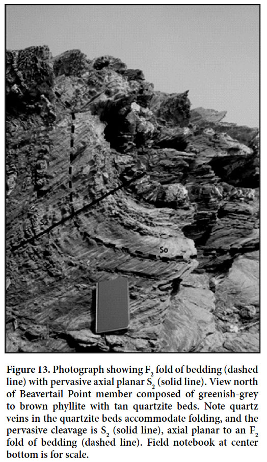
31 The youngest fold generation, F3, is recorded by map-scale gentle to open folding of S2. This fold generation is inferred from changes in S2 orientation along continuous exposure on the coastline of Beavertail State Park (Fig. 1c). On the western coastline of the park, the S2 fabric dips moderately to the west, whereas it is shallowly dipping on the eastern coastline (Figs. 1–3). Poles to S2 and F2 axial planes spread along a WNW to ESE-striking girdle defining a NNE-trending fold axis (Fig. 7b), consistent with a shallowly plunging NNE-trending F3 fold axis. Although defined by the change in S2 orientation, F2 and F1 folds, S1 and early faults are also observed to be folded by this generation. For example, F2 folds change from overturned to recumbent across the F3 folds (Figs. 2, 3).
32 In thin section, mica-rich layers of the Short Point member contain post-S2 crenulations. These crenulations formed only on highly pressure-solved limbs of S2 crenulations along very mica-rich bands. The crenulations are at moderate to high angles to S2 (Fig. 14) with wavelengths of <0.075 mm and up to 0.15 mm in amplitude. Multiple sets of differently oriented, and locally cross-cutting, crenulations are observed within the same thin section. Locally, crenulations curve from low to high angles relative to S2, and some are localized between siderite nodules, indicating that shearing may have accompanied their development. No spatial relationship to F3 is observed; hence we term these S C , because their relationship to post-F2 deformation is unknown.
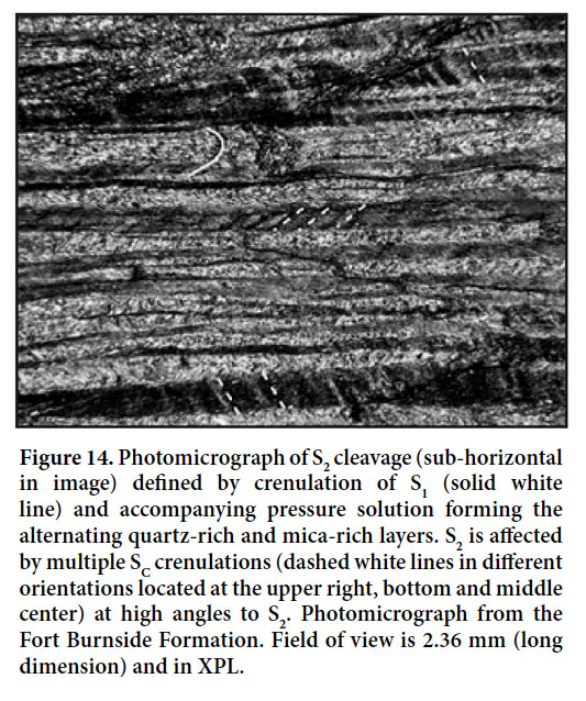 Display large image of Figure 14
Brittle deformation and associated structures
33 Boudinage commonly warps bedding and the S2 fabric. Boudins are generally 1–3 m in length, but locally are up to 15 m. Most boudins are rounded with flat edges at their necks. Quartzite layers acted competently, whereas phyllitic layers were more ductile. Within completely mica-rich areas, the layers display foliation boudinage and blocky quartz veins are common in neck regions. The trend of several boudins displays predominantly N-S extension.
34 After the formation of F2 and S2 and before brittle faulting, another generation of quartz and/or siderite veins formed. The veins vary from blocky to fibrous and some contain chlorite as well. Styles of veining include quartz and/or siderite filled en échelon extension fractures, planar quartz and siderite veins, and large blocks of vein quartz with minor chlorite. The latter blocks range in size from 1–3 m 2 and are typically separated by 5–15 m. Because vein quartz is commonly present at the necks of several small-scale boudins, this observation suggests that these blocks are necks of large-scale boudins. In addition, sigmoidal and planar en échelon quartz veins cross cut S2. Arrays of these veins typically range from 0.5–1 m but are up to 10 m in length with widths of 15–30 cm to 5 m. Spacing between en échelon fractures is typically 1–3 cm, but can be up to a metre. Within an array, thicknesses of individual veins range from 1–15 cm. Planar veins that commonly cut S2 vary from 0.1 cm to 10 cm in thickness. Planar veins display a variety of orientations, but generally strike NW and dip moderately SW suggesting NE-SW extension (Fig. 15a). The wide variety of quartz veins that were emplaced prior to, during, and after F2 indicates that silica was mobile throughout deformation.
35 A 1–2 m thick lamprophyre dyke in Beavertail State Park cross-cuts S2 and all fold generations (Fig. 1c). The dyke is composed of quartz, carbonate (replacement of quartz), feldspar, and muscovite with minor pyrite. It strikes roughly NW-SE and dips rather shallowly (~30°) to the SW and is not reoriented along with S2 by the map-scale F3 fold, indicating its emplacement post-dated F3. Its orientation is similar to that of most planar quartz veins and suggests that it may be associated with the NE-SW extension related to the veins. Locally, the dyke displays pinch and swell type boudinage over 3–4 m. Also, it is cut by brittle faults and pervasively by several quartz and calcite veins.
36 Brittle faults and related fractures with no demonstrable offset cut all fold generations (F1, F2, and F3), their associated fabrics (S1 and S2), the dyke and all other structures. Faults and related fractures strike N to NE and ENE to ESE (Figs. 2, 15b). Sense of motion on faults was determined from quartz and chlorite slickenlines, deflection of S2 offset beds and/or displacement on spatially associated kink bands (see below). Minor sinistral and dextral motions were observed, but normal motion is predominant (Fig. 15c). T-axes generally trend NW-SE and P-axes have a variety of orientations, but are mostly steeply plunging. These data indicate normal motion with extension in the NW-SE direction. Although previous maps (e.g., Skehan et al. 1981) and those from this study (also see Carter 2008) show a large number of steeply dipping “faults” in these same orientations; most do not show demonstrable offset of structures, unit contacts or layers, and commonly structures continue across the “fault” with no offset. These features are visually prominent because of the intense wave erosion along this coastline, but without evidence of offset (or with evidence of no measurable offset) should best be termed fractures. The largest offset measured on any of the faults is on the Beavertail fault of Skehan et al. (1981), which has no more than 5 m of normal throw based on offset of the prominent NW-trending lamprophyre dyke.
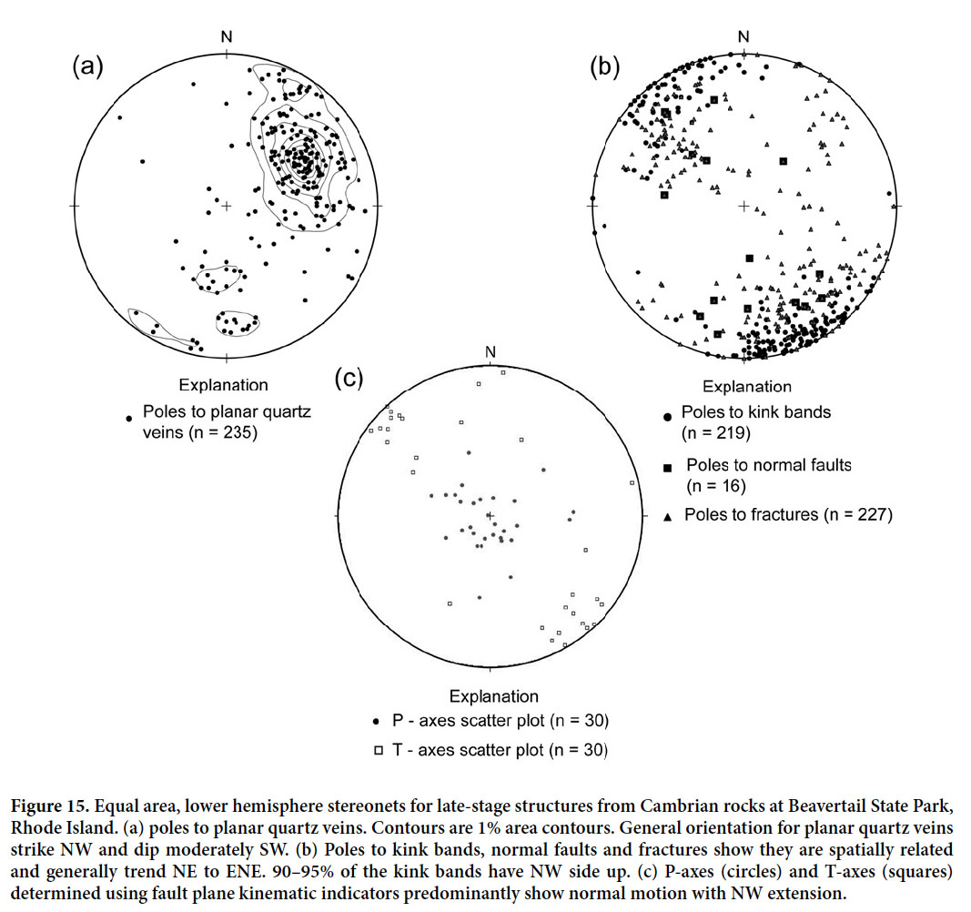 Display large image of Figure 15
37 Kink bands of S2 are spatially associated with the brittle faults (Fig. 15b) and vary from a few to multiple arrays covering areas up to a metre wide. Kink bands range from 5 mm to 10 cm across, though on average are 1–3 cm wide. They typically strike sub-parallel to faults, trending NNE to ENE. In some localities, kink bands adjacent to faults are oriented oblique to the fault by ~10–30° and form en échelon arrays indicating oblique motion; some indicate faults with sinistral and others with dextral components of motion. Almost all kink bands record a NW side up motion of no more than 1–2 cm, consistent with the NE-strike of normal faults, predicted from the T and P axes.
38 The vertical Beaverhead shear zone (BHSZ), located in the northwestern part of the field area, juxtaposes the Cambrian formations with Pennsylvanian formations of the Narragansett Basin and affects the S2 fabric (Fig. 1c). Near the BHSZ, the strike of S2 in the Cambrian rocks shows progressive clockwise rotation (Fig. 1c). The deflection of S2 as it approaches the BHSZ is consistent with dextral motion and indicates that S2 developed prior to the last recorded dextral motion on the zone (Mosher 1983; Mosher and Berryhill 1991; Burks and Mosher 1996).
Metamorphism
39 The dominant metamorphic mineral is muscovite which is aligned parallel to S1. The only metamorphic index mineral present is chlorite, and it is either sub-parallel or at high angles to S1. In addition, rare tails of chlorite and clinozoisite have grown parallel to S2 off pyrite, siderite, and siliceous nodules. Round grains that resemble isolated sand grains are composed of chlorite. The freshness and distinct grain shape of the chlorite suggest that it replaced a preexisting detrital mineral of a different composition during metamorphism. Given the absence of biotite, the metamorphic grade of this area could not have been higher than lower greenschist facies, and peak temperatures occurred during the formation of S1, and continued during the development of S2. Whole rock 40 Ar/ 39 Ar cooling ages for muscovite which defines the S1 fabric in the Cambrian rocks ranges from 240 to 260 Ma (Dallmeyer 1982).
DISCUSSION
Comparison with Pennsylvanian rocks of the Narragansett Basin
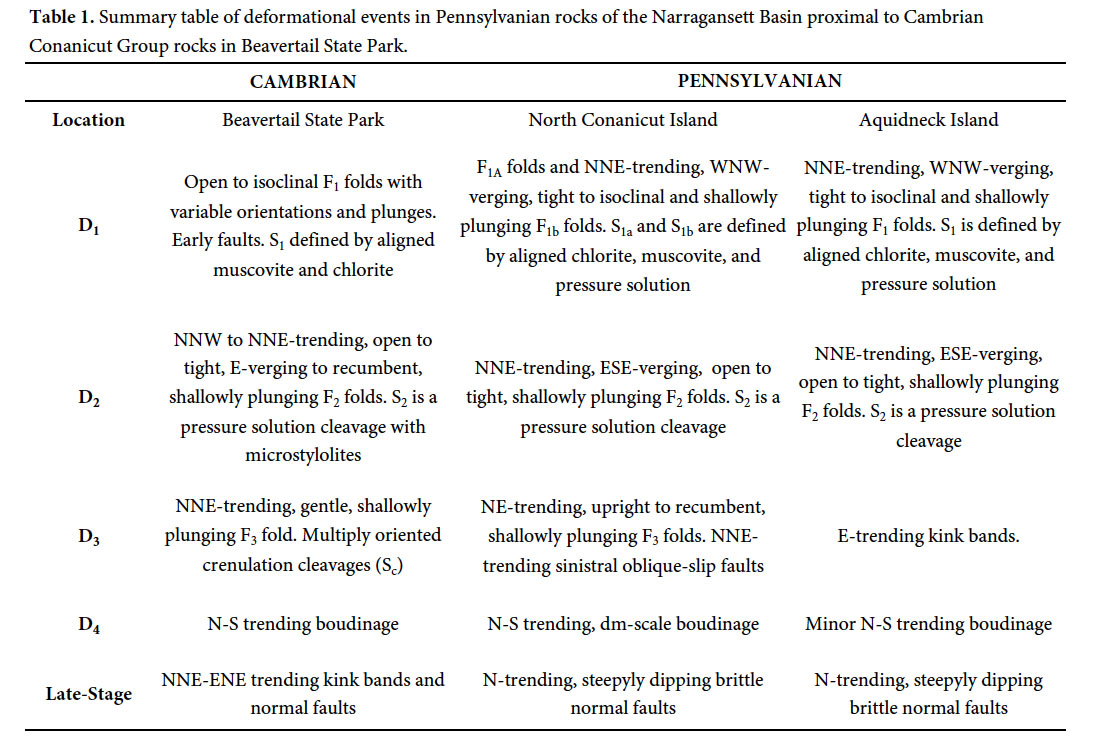
40 Because the Pennsylvanian metasedimentary rocks are intensely deformed by D3 and D4 within the Beaverhead shear zone and to a lesser extent along other faults and shear zones, it is appropriate to compare Pennsylvanian rocks on Conanicut and Aquidneck islands (Fig. 1b) that lie outside the BHSZ with the Cambrian rocks south of the shear zone. Garnet- to staurolite-grade metasedimentary rocks on Conanicut Island to the north are geographically closest, but rocks on Aquidneck Island to the east are at the same metamorphic grade as the Cambrian rocks and hence more directly comparable. The summary below is based on extensive research by S. Mosher and her students (also see Farrens 1982; Henderson and Mosher 1983, and summary in Snoke and Mosher 1989).
41 In Pennsylvanian rocks on Conanicut Island, the first deformation produced F 1a and F 1b folds and associated S 1a and S 1b axial planar foliations, whereas on Aquidneck Island only one generation (F1 and S1) was produced. F 1b and F1 are generally tight to isoclinal, NNE-trending, WNW-verging, shallowly plunging folds (Fig. 7c, Table 1). S 1a,b and S1 are defined by very well-developed parallel arrangement of muscovite and chlorite in phyllite and schist and pressure solution cleavage in more quartz-rich rocks. Open to tight, NNE-trending, shallowly plunging, ESE-verging F2 folds deform S 1a,b and S1 and are nearly coaxial to F 1b and F1, respectively (Fig. 7c, Table 1). F2 folds have an associated axial planar crenulation cleavage, S2, enhanced by pressure solution. F2 folds are more numerous on Aquidneck Island. In the higher metamorphic grade Pennsylvanian rocks on Conanicut Island, garnet, staurolite, and biotite grew between D1 and D2.
42 Evidence of D3 and D4 are expressed on both islands, but to different extents. On Conanicut Island, numerous NNE-trending sinistral oblique-slip faults are observed. Adjacent to the faults, NE-trending, shallowly plunging, upright to recumbent F3 folds (Fig. 7d, Table 1) with an axial planar crenulation cleavage is present, along with sinistral tension gashes and sheath folds. On Aquidneck Island, S1 and S2 are affected only by E-trending kink bands, although the spread of S2 along an ESE-trending girdle suggests later open refolding (Fig. 7d, Table 1). On both islands, late-stage boudins with N-S extension affected the metasedimentary rocks. Boudinage is more prevalent on Aquidneck Island where decametre-scale foliation boudinage is observed. In some localities on Aquidneck Island, clockwise younging superposed crenulation cleavages are present. Lastly, on both islands, earlier structures are cut by N-trending, steeply dipping brittle normal faults.
43 Structures and associated foliations and cleavages affecting the Cambrian rocks are very similar in style, orientation, relative timing, and deformation fabrics to those affecting the adjacent Pennsylvanian rocks on Conanicut and Aquidneck islands. Previous workers have suggested correlation of all but the first generation structures, and by implication that F1 in the Pennsylvanian rocks equates to F2 in the Cambrian rocks. However, F1 folds affecting the Pennsylvanian rocks verge westward, whereas F2 folds in the Cambrian rocks verge eastward. It is highly unlikely that correlative fold generations in adjacent localities would have different vergences. Additionally, F2 in both Pennsylvanian and Cambrian rocks verges eastward and has similar deformation fabrics. Hence, correlation of F2 between localities is more plausible. F1 folds in both areas are tectonic in origin and have the same orientations, styles, and minerals defining the fabrics. Given the proximity of these rocks, it is unlikely that the Cambrian rocks escaped the more penetrative first deformation to affect the Pennsylvanian rocks. Thus we correlate F1 folds in the Cambrian and Pennsylvanian rocks.
44 Subsequent structures (including faults, kink bands, multiple cross-cutting crenulations, and boudins) are also similar and readily correlated. The gentle to open F3 folds affecting the Cambrian rocks may be correlative with the F3 folds associated with D3 sinistral shear along faults in the basin, but more likely are similar to the later N-trending F4 folds observed further west at Bonnet Shores in the basin (Fig.1b) associated with D4 (Reck and Mosher 1988). On the rest of Conanicut and Aquidneck islands, exposure is primarily restricted to N-trending outcrops which are not optimal for viewing gentle to open folds in this orientation, although as noted above, S2 on Aquidneck Island appears folded on a regional scale. On Bonnet Shores, gentle to open N-trending F4 folds were observed to reorient the S2 crenulation cleavage. Normal, sinistral, and dextral faults in the same orientations affect both Cambrian and Pennsylvanian rocks. On the basis of the remarkable similarity of structures in all respects, we propose that all deformation recorded in the Cambrian rocks occurred during the Alleghanian orogeny, or possibly later in the case of normal faults.
45 The relative timing of metamorphism and deformation is the same in both the Pennsylvanian and Cambrian rocks. Additionally, 40 Ar/ 39 Ar muscovite dates of about 250 Ma from Aquidneck Island (Pennsylvanian rocks) and from whole-rock phyllite samples from Beavertail State Park (Cambrian rocks), which are at the same metamorphic grade, are the same within error and show similar age spectra (Dallmeyer 1982). All the 40 Ar/ 39 Ar muscovite cooling ages are 240 to 260 Ma across the range of metamorphic grades in the Narragansett Basin (Dallmeyer 1982).
 Display large image of Table 1
Comparison with previous interpretations
46 Our results are more compatible with the preliminary work by Murray and Skehan (1979) and Burks (1981) than later work by Skehan et al. (1981) and Skehan and Rast (1990). Detailed petrographic work described above demonstrates unequivocally that F1 folds are tectonic structures and S1 a metamorphic fabric, not soft-sediment slump features. During our mapping at a scale of 1:1000, we observed no thrust faults on S2 cleavage planes. Also, thrusting along S2 could not have caused folding of quartz veins as S2 is axial planar to the folded quartz veins. The early faults we observed are folded by F2 and are associated with the formation of F1, truncating one limb of F1 folds.
47 We also found no evidence that the Cambrian rocks were thrust northwestward over the Pennsylvanian rocks along the BHSZ during D1 as proposed by Skehan and Rast (1990). Thrusting and fold vergence in the Narragansett Basin during D1 was to the west (e.g., Mosher 1983, 1987), not northwest. In addition, detailed mapping of the Cambrian rocks adjacent to the BHSZ and Pennsylvanian rocks on the eastern shore of Conanicut Island adjacent to the trace of the BHSZ by Henderson and Mosher (1983) did not find any evidence for thrusts. On the western shore, no exposures were found near the contact, and no thrusts are observed. Pennsylvanian rocks in Fort Getty State Park lie within the vertical BHSZ and are intensely deformed by both D3 and D4.
48 Deformation in the Narragansett Basin is interpreted to have resulted from closure of the basin as a result of final collision of Africa with North America, with first west-directed deformation (D1) followed by back-folding with eastward vergence (D2) (Mahler-Cogswell and Mosher 1994). Subsequent interaction between the two continents is interpreted to have caused sinistral shear along NNE-trending zones in the western passage of Narragansett Bay and the western basin margin (D3), followed by dextral shear along a NE-trending zone, including the BHSZ and southwestern part of the basin (Mahler-Cogswell and Mosher 1994). The deformation of the Cambrian rocks matches that of the basin outside of the intense shear zones, and thus is compatible with this tectonic model.
49 The proposal by Skehan and Rast (1990) and Rast and Skehan (1990) that the BHSZ is a terrane boundary between the Esmond-Dedham and Bulgarmarsh terranes is not substantiated by our work or other work in the basin. Our work also does not support the suggestion of Skehan and Rast (1990) that the Cambrian rocks are part of the Meguma terrane which was thrust over the Pennsylvanian rocks along the BHSZ from some distance to the southeast as a result of a north- to northwest-directed collision during D1 and followed by a north-directed D2. No structures in the southern Narragansett Basin or adjacent Cambrian rocks show evidence of NW- or N-directed transport. As discussed above, transport during D1 in the southern part of the basin was westward and during D2 was eastward. The northern part of the basin located far from the BHSZ shows ENE-trending fold axes, but they follow the basin margins and were likely caused by closure of the basin and not likely to be related to D1 or D2 in the south (Mosher 1983). Additionally, the low-grade, open to tight, NNE-trending, E-verging F2 folds with associated crenulation cleavage enhanced by pressure solution observed in both Cambrian and Pennsylvanian rocks could not have formed as a result of N-directed thrusting.
50 Moreover, Pennsylvanian rocks of the Narragansett Basin lie on both sides of most of the BHSZ (Fig. 1b), and the grade of metamorphism is similar across the zone. The chlorite-grade Cambrian rocks (this study) are adjacent to biotite-grade Pennsylvanian rocks on Beaverhead at Fort Getty State Park (Burks 1981) and eastern Conanicut Island (Henderson and Mosher 1983); chlorite-grade rocks on Aquidneck Island (Farrens 1982) are adjacent to biotite-grade rocks on Prudence Island (Thomas 1981) (see Fig. 1b for locations). Also, the Pennsylvanian fossils have the same age range (Stephanian) on both sides of the shear zone (Skehan et al. 1986). Thus, no evidence exists that the BHSZ is a major thrust fault. If a major terrane boundary exists underneath the Narragansett Basin, terrane accretion occurred prior to the formation of the basin; otherwise pre-Alleghanian structures would likely be preserved in the Cambrian rocks.
51 We propose that the Cambrian sediments were deposited on older Neoproterozoic Avalonian basement and remained undeformed until the Alleghanian orogeny. We suggest that deformation related to the accretion of this part of Avalonia to composite Laurentia was accommodated in the western margin of the SENE Avalon terrane (i.e., the Hope Valley terrane) and that the Cambrian rocks escaped deformation until the Alleghanian orogeny. The Pennsylvanian sediments of the Narragansett Basin were deposited on both Neoproterozoic Avalonian basement and on Cambrian sedimentary rocks, at least in the southernmost part of the basin.
CONCLUSIONS
52 Deformation recorded by Cambrian rocks at Beavertail State Park is correlative with that in Pennsylvanian rocks of the Narragansett Basin. Field mapping and petrographic analysis allow comparison of structures within the two areas. Results indicate that the sequence of deformation and metamorphism, as well as the styles, orientations and geometries of structures are nearly identical, as are deformational fabrics. No evidence exists for structures associated with deformation earlier than the Alleghanian orogeny exists. Hence, all deformation and metamorphism of the Cambrian rocks is interpreted to have occurred during the Alleghanian orogeny.
53 Our study further shows that the proposed northwestward thrusting of a Meguma-like terrane onto the Pennsylvanian rocks followed by north-directed transport during the Alleghanian orogeny is incompatible with the deformation history of the area. No evidence supporting such thrusting is observed. If the Beaverhead shear zone is a reactivated terrane boundary between the Esmond-Dedham and another Avalonian terrane, accretion must have occurred before the deposition of the Cambrian and Pennsylvanian sediments.
This research was funded by the Geological Society of America. The substantial field work in the Narragansett Basin by former students of Dr. Sharon Mosher (R.J. Burks, C.M. Farrens, M.C. Henderson, J.P. Mahler-Cogswell, A.W. Berryhill, B.H. Reck, and K.J. Thomas) was crucial to the completion of this study. We would also like to thank Dr. Sandra Barr and two anonymous reviewers for helpful suggestions on an earlier version of this paper. Lastly, we greatly appreciate the staff at Fort Getty State Park for their camping accommodations during field work.