Articles
A review of Proterozoic to Early Paleozoic lithotectonic terranes in the northeastern Appalachian orogen of New Brunswick, Canada, and their tectonic evolution during Penobscot, Taconic, Salinic, and Acadian orogenesis
ABSTRACT
Geological relationships preserved in the New Brunswick segment of the Appalachian orogen are key to deciphering the complex tectonic events that occurred during the closing of the Paleozoic Iapetus Ocean. These events can be explained in terms of geodynamic interactions between eight lithotectonic terranes. The first, the Caledonia terrane, comprises Neoproterozoic volcanic arc sequences and comagmatic plutons considered to form part of the microcontinent of Avalonia. The seven other terranes are associated with the microcontinent of Ganderia and consist of (1) Brookville terrane–Mesoproterozoic to Neoproterozoic platformal carbonates and Neoproterozoic to Early Cambrian plutonic rocks, (2) New River terrane–Neoproterozoic volcanic arc sequences and comagmatic plutons overlain by a Cambrian Penobscot volcanic arc sequence, (3) Annidale terrane–Upper Cambrian to lower Lower Ordovician Penobscot volcanic arc-backarc sequence and unconformably overlying upper Lower Ordovician volcanic sequence, (4) St. Croix terrane–Cambrian to Upper Ordovician sedimentary sequence deposited on the passive margin of the New River terrane, (5) Miramichi terrane–Cambrian to Lower Ordovician sedimentary sequence and unconform-ably overlying Middle to Upper Ordovician Tetagouche volcanic backarc sequence; and Lower to Middle Ordovician Meductic volcanic arc sequence, (6) Elmtree terrane–Middle to Upper Ordovician backarc ophiolitic sequence, and (7) Popelogan terrane–Middle to Upper Ordovician volcanic arc sequence.
In New Brunswick, closure of the Iapetus Ocean is attributed to four major tectonic episodes: (1) the Penobscot orogeny, which accreted the Miramichi, Annidale, and St. Croix terranes to the New River terrane on the trailing edge of Ganderia by closing a Penobscot backarc basin in the Early Ordovician, (2) the Taconic orogeny, which accreted the Popelogan terrane on the leading edge of Ganderia to the Laurentian margin in the Late Ordovician and effectively closed the main tract of the Iapetus Ocean, (3) the Salinic orogeny, which accreted the Elmtree and Miramichi terranes to the Laurentian margin by closing the Tetagouche backarc basin in the Silurian, and (4) the Acadian orogeny, which accreted the Caledonia terrane (Avalonia) to the Brookville and New River terranes on the trailing edge of Ganderia in the latest Silurian to earliest Devonian and in the process closed the last remaining oceanic tract in the northeastern Appalachians.
RÉSUMÉ
Les corrélations géologiques préservées dans la partie du Nouveau-Brunswick de l’orogène des Appalaches sont essentielles pour bien comprendre le déroulement des événements tectoniques complexes survenus au moment de la fermeture de l’océan Iapetus, pendant le Paléozoïque. Il est possible d’expliquer ces événements par des interactions géodynamiques entre huit terranes lithotectoniques. Le premier, soit le terrane calédonien, comprend des séquences d’arc volcanique et des plutons comagmatiques du Néoprotérozoïque dont on estime qu’ils faisaient partie du micro-continent Avalonia. Les sept autres terranes sont associés au microcontinent Ganderia et comprenaient les terranes que voici : (1) le terrane Brookville – formé de carbonates de plate-forme du Mésoprotérozoïque au Néoprotérozoïque et de roches plutoniques du Néoprotérozoïque au début du Cambrien; (2) le terrane New River – formé de séquences d’arc volcanique du Néoprotérozoïque et de plutons comagmatiques recouverts par une séquence d’arc volcanique de Penobscot du Cambrien; (3) le terrane Annidale – formé d’une séquence d’arc-arrière-arc volcanique de Penob-scot du Cambrien supérieur au début de l’Ordovicien inférieur, qui repose en discordance sur une séquence volcanique de la fin de l’Ordovicien inférieur; (4) le terrane Ste‑Croix – formé d’une séquence sédimentaire du Cambrien à l’Ordovicien supérieur, déposée sur la marge passive du terrane New River; (5) le terrane Miramichi – formé d’une séquence sédimentaire du Cambrien à l’Ordovicien inférieur, qui repose en discordance sur une séquence d’arrière-arc volcanique de Tetagouche de l’Ordovicien intermédiaire à supérieur, et sur une séquence d’arc volcanique de Meductic de l’Ordovicien inférieur à intermédiaire; (6) le terrane Elmtree – formé par un cortège d’arrière-arc ophiolitique de l’Ordovicien intermédiaire à supérieur; et (7) le terrane Popelogan – formé par une séquence d’arc volcanique de l’Ordovicien intermédiaire à supérieur.
Au Nouveau-Brunswick, la fermeture de l’océan Iapetus est attribuée à quatre épisodes tectoniques majeurs : (1) l’orogenèse Penobscot, qui a formé le terrane New River par accrétion des terranes Miramichi, Annidale et Ste‑Croix, sur le flanc résiduel de Ganderia, par la fermeture du bassin marginal de Penobscot au début de l’Ordovicien; (2) l’orogenèse taconique qui a formé le terrane Popelogan par accrétion sur la marge laurentienne de la partie frontale de la nappe de Ganderia à la fin de l’Ordovicien, ce qui a effectivement ceinturé définitivement la principale étendue de l’océan Iapetus; (3) l’orogenèse salinique, qui a formé par accrétion les terranes Elmtree et Miramichi sur la marge laurentienne, par la fermeture du bassin marginal de Tetagouche au cours du Silurien; et (4) l’orogenèse acadienne, qui a formé le terrane calédonien (microcontinent Avalonia) par accrétion sur les terranes Brookville et New River, sur le flanc résiduel de Ganderia, entre la fin du Silurien et le début de Dévonien; au cours de cette période, les dernières traces d’océan ont disparu du nord-est des Appalaches.
[Traduit par la redaction]
INTRODUCTION
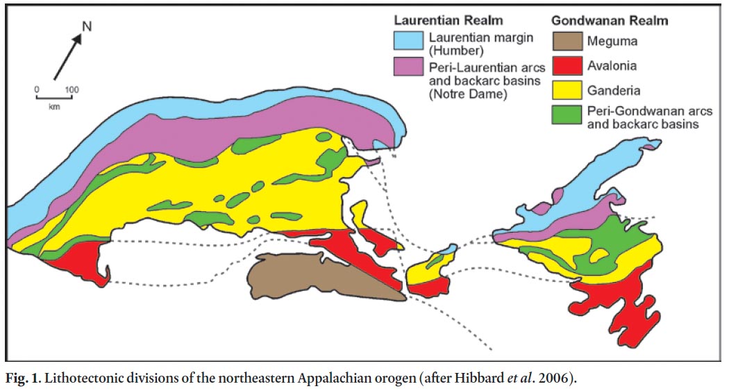
1 A significant advance was made in the understanding of the tectonic evolution of the Appalachian orogen with the introduction of four lithotectonic divisions on the island of Newfoundland, those being the Humber, Dunnage, Gander and Avalon zones (Williams et al. 1972; Williams 1978, 1979). In this scheme, the Humber Zone in the west and Avalon Zone in the east were interpreted as the Laurentian and Gondwanan platformal margins, respectively, of the Paleozoic Iapetus Ocean. The intervening, complexly deformed axial region of the Newfoundland Appalachians, referred to as the Central Mobile Belt (Williams 1964), was characterized by thick quartz-rich turbiditic sequences of the Gander Zone, and volcanic arc and backarc sequences of the Dunnage Zone (Fig. 1). The Gander Zone was thought to represent the more outboard part of the Gondwanan margin, the inboard part of which was represented by the Avalon Zone. Such an interpretation necessitated a close linkage between these two zones, a view that now is a matter of some controversy.
2 As Fyffe (1977) and van der Pluijm and van Staal (1988) pointed out, some difficulties were encountered in applying this early lithotectonic zonation as defined in Newfoundland to the mainland of Atlantic Canada (for example, see Rast et al. 1976). However, the recognition that the Early Ordovician Penobscot orogeny, first defined in Maine (Neuman 1967), had affected other parts of the Gander Zone led to a more realistic model for the Early Paleozoic plate tectonic evolution of the northeastern Appalachians (Colman-Sadd et al. 1992; van Staal 1994; van Staal et al. 1996, 1998, 2003, 2009; Hibbard et al. 2006). These authors presented evidence that the Gander Zone of Williams (1979) formed part of a peri-Gondwanan microcontinent, referred to as Ganderia, which was separate from the Avalon Zone or Avalonia (Fig. 1). Ganderia was also shown to include volcanic arc and backarc elements of the Exploits Subzone of the Dunnage Zone (Williams et al. 1988), thus obscuring the distinctiveness of the Gander and Dunnage zones. Elements of the Notre Dame Subzone of the Dunnage Zone, formed along the Laurentian continental margin, are not exposed in New Brunswick but may occur in the subsurface beneath covering rocks of the Matapédia Basin in the northwestern part of the province (van Staal et al. 1998; Moench and Aleinikoff 2003; Dupuis et al. 2009).
3 This paper presents a comprehensive review, largely from an historical perspective, of the work carried out in New Brunswick between 1970 and 2010 that has led to the present understanding of the plate tectonic evolution of this part of the Appalachian orogen. Since 1990, in particular, a large amount of new stratigraphic, geochemical, geochronological, and structural data have been collected by van Staal and co-workers at the Geological Survey of Canada; Sandra Barr and students at Acadia University; Damian Nance at Ohio University; and staff of the Geological Surveys Branch at the New Brunswick Department of Natural Resources. This work involved detailed mapping of dozens of quadrangles throughout southern New Brunswick (Fyffe and Riva 1990; McLeod et al. 1992, 2001; McLeod 1995, 1997; Barr and White 1996a, b, 1999; Johnson and McLeod 1996; White and Barr 1996; Currie and McNicoll 1999; Fyffe et al. 1999; Fyffe 2001, 2005; Fyffe and Grant 2001; Barr et al. 2002) and northern New Brunswick (Wilson 1990, 2000, 2002; van Staal and Fyffe 1995; van Staal et al. 2003; Wilson et al. 2004).
4 Integration of the recent information gathered in New Brunswick with that of other regions of Atlantic Canada and northwestern Europe has led to the creation of plate tectonic models for the entire Appalachian-Caledonian mountain belt (Nance et al. 2002; van Staal et al. 1998, 2009; Murphy et al. 1999; van Staal and Barr in press). These generalized global syntheses provide important insights into the plate tectonic evolution of an orogenic system as a whole but in the interest of conciseness do not allow for full discussions about every segment in the mountain belt. What follows is intended to fill this gap by describing the paleogeographic setting of the various terranes now recognized in New Brunswick and examining their plate tectonic interactions in terms of the geodynamic framework related to closure of the Iapetus Ocean. The detailed stratigraphic charts that accompany this text serve as an update to those presented in an earlier terrane analysis of New Brunswick by Fyffe and Fricker (1987).
 Display large image of Figure 1
GEOLOGICAL OVERVIEW OF NEW BRUNSWICK TERRANES
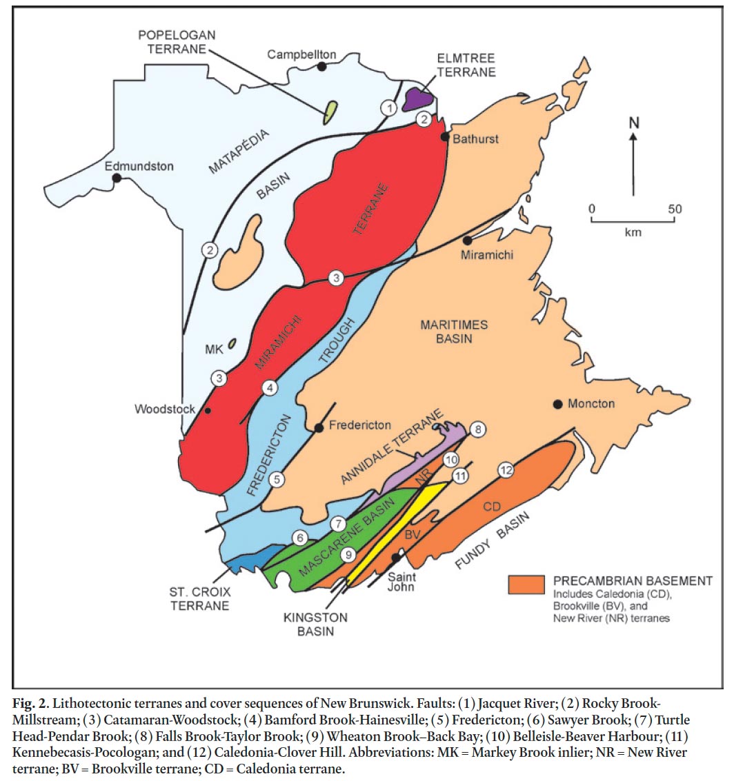
5 Ruitenberg et al. (1977) were the first to describe a geological zonation of New Brunswick and to present a general plate tectonic model explaining the development of these zones. Subsequently, Fyffe and Fricker (1987) applied the terrane concept of Coney et al. (1980) to better constrain the timing of tectonic events in the various zones by introducing the terms Avalonian, Mascarene, St. Croix, Miramichi, and Elmtree terranes (Figs. 2, 3). These terranes, following the concept of Williams (1978, 1979), were distinguished on the basis of their distinctive Lower Paleozoic lithotectonic sequences as compared with adjacent fault blocks. The gathering of much new information since the publication of Fyffe and Fricker (1987) has resulted in the recognition of additional terranes in New Brunswick, those being the Popelogan terrane of northern New Brunswick; and the Caledonia, Brookville, New River, and Annidale terranes of southern New Brunswick (Figs. 2, 3). The stratigraphy and plutonic histories of these terranes are summarized below in order to provide the regional geological context in which to describe the Paleozoic plate tectonic evolution of the New Brunswick segment of the Appalachian orogen. For detailed kinematic analyses of some of the terrane-bounding faults in New Brunswick, the reader is referred to Brown and Helmstaedt (1970), Brown (1972), Garnett and Brown (1973), Park et al. (1994, 2008), de Roo and van Staal (1994), and van Staal and de Roo (1995).
6 The type Penobscot unconformity between Cambrian to Lower Ordovician and Middle Ordovician sequences was defined in north-central Maine by Neuman (1964) and subsequently was recognized in northeastern New Brunswick by Fyffe (1976, 1982). However, geological mapping and geo-chronological studies only recently have provided definitive evidence of Penobscot orogenesis in southern New Brunswick (Johnson et al. 2009). Specifically, the Ganderian terranes in the south (New River and Annidale, Fig. 3) have been shown to contain Penobscot-related magmatism and tectonism. Consequently, this paper emphasizes integrating the tectonic evolution of the Ganderian terranes in southern New Brunswick with those in the north. The northern terranes (Miramichi, Elmtree, and Popelogan) are dominated by the previously documented development and destruction of the Tetagouche backarc basin, events that culminated in a younger period of Late Ordovician to Silurian Salinic orogenesis (van Staal 1987, 1994; van Staal et al. 1990, 1991, 1996, 1998, 2003; van Staal and Fyffe 1991, 1995).
7 As now understood, both of the microcontinents of Ganderia and Avalonia are exotic to Laurentia, having rifted from different parts of the Gondwanan margin by opening of the Rheic Ocean in the Early Paleozoic. Specifically, Avalonia separated from the West African craton or northeastern Amazonia (McNamara et al. 2001; Murphy et al. 2002; Thompson et al. 2007, 2010; van Staal et al. 2009; van Staal and Barr in press), and Ganderia separated from northwestern Amazonia (van Staal et al. 1996, 2009; Schultz et al. 2008; Fyffe et al. 2009). Contemporaneous extension along the Gondwanan margin of the Iapetus Ocean led to the development of arc-backarc systems on the leading edge of Ganderia between the Middle Cambrian and Late Ordovician. These volcanic arc ‘terranes’ were re-united with the trailing edge of the Ganderian micro-continent during closure of associated backarc basins, such that they never became permanently detached from their immediate source area (van Staal and Hatcher 2010). The Ganderian microcontinent itself can therefore be considered as a ‘superterrane’ composed of volcanic arc terranes rifted from, and then re-attached to, Ganderia during Penobscot and Salinic orogenesis.
 Display large image of Figure 2
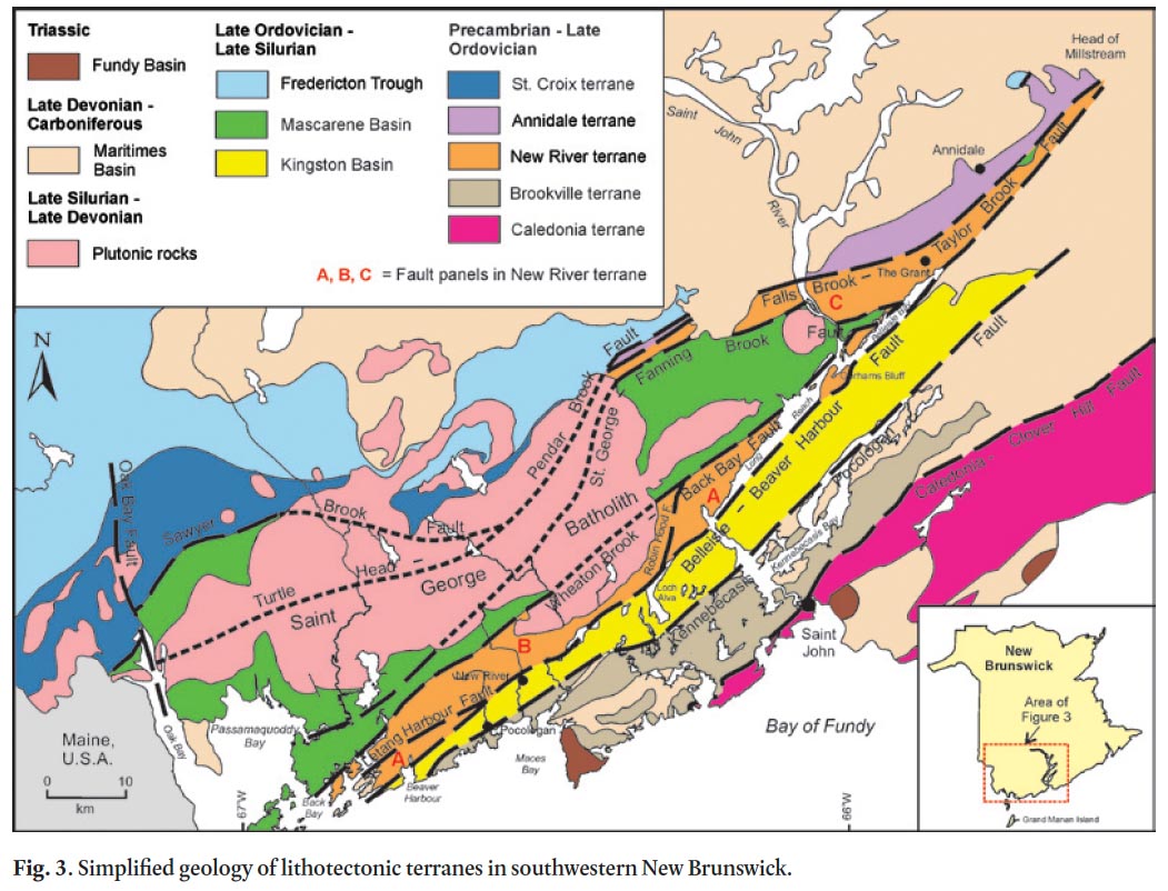
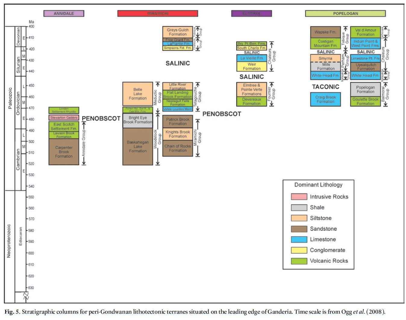
8 The various terranes recognized in New Brunswick are described under two headings according to whether their oldest contained rocks are Proterozoic or Early Paleozoic. Stratigraphic columns for the terranes are arranged according to paleotectonic setting: terranes situated on the Iapetan trailing edge of Ganderia are illustrated on Figure 4, and those on the leading edge are shown on Figure 5.
 Display large image of Figure 3
PROTEROZOIC TERRANES
9 Proterozoic terranes in New Brunswick include New River, Brookville, and Caledonia, all in southern New Brunswick. The boundary between Brookville and Caledonia terranes is marked by the Caledonia-Clover Hill Fault (Figs. 2, 3). The New River and Brookville terranes are separated from each other by a belt of Lower Silurian, mainly felsic volcanic rocks of the Kingston Basin (McLeod et al. 2001; Barr et al. 2002). The New River terrane lies north of the Kingston Basin and is separated from it by the Belleisle-Beaver Harbour Fault (Johnson and McLeod 1996). The Brookville terrane (White and Barr 1996) lies south of the Kingston Basin and is separated from it by the Kennebecasis-Pocologan Fault.
10 The New River and Brookville terranes are considered herein to represent the trailing edge of the Ganderian microcontinent that was rifted from the Gondwanan margin in the Early Paleozoic. This interpretation is based on the shared presence of thick, Neoproterozoic to Early Paleozoic Gander Group-like, quartz-rich sandstone sequences, which are absent in Avalonia (van Staal et al. 1996; Hibbard et al. 2006; Fyffe et al. 2009). Rocks similar to those of the New River and Brookville terranes also occur offshore in the Grand Manan archipelago at the western end of the Bay of Fundy (inset, Fig. 3), where they are offset from the trend on the mainland by the sinistral Oak Bay Fault (Hutchinson et al. 1988; Pe-Piper and Wolde 2000; Fyffe and Grant 2001; Barr et al. 2003b; Black et al. 2004; Miller et al. 2007). The preservation of Ganderian continental-margin sedimentary rocks on Precambrian basement is a unique feature of the New Brunswick Appalachians. Readers are referred to Fyffe et al. (2009), and references therein, for information on the pre-Iapetus tectonic history of the Brookville and New River terranes.
11 The Caledonia terrane in coastal New Brunswick has many stratigraphic and geochemical characteristics in common with Avalonian terranes elsewhere, such as the Mira terrane in Nova Scotia (Barr and Raeside 1989; Barr and White 1996a, b) and the Avalon Zone of Newfoundland (O’Brien et al. 1996; Barr and Kerr 1997). The adjacent Brookville and New River terranes are considered by some workers to also be part of an Avalon Composite terrane in the sense that it is defined to include basement rocks once thought to have a continuous overlapping platformal sequence represented by the Saint John Group (Currie 1986, 1988; Nance 1986, 1987, Nance et al. 1991a, b; Fyffe and Fricker 1987; Landing 1996a, b; Currie and McNicoll 1999; Westrop and Landing 2000; Landing and MacGabhann 2010). Others exclude the Brookville and New River terranes from Avalonia. Instead, they consider the presence of similar sequences historically included in the Saint John Group (Hayes and Howell 1937) to indicate that the terranes were rifted from different parts of an extensive Gondwanan continental margin characterized by similar depositional histories (Barr and White 1996b; Barr et al. 2003a). The Bras d’Or and Aspy terranes of Cape Breton Island in Nova Scotia correspond to the Brookville and New River terranes, respectively, in New Brunswick (Barr and Raeside 1989; Barr et al. 1998; Lin et al. 2007).
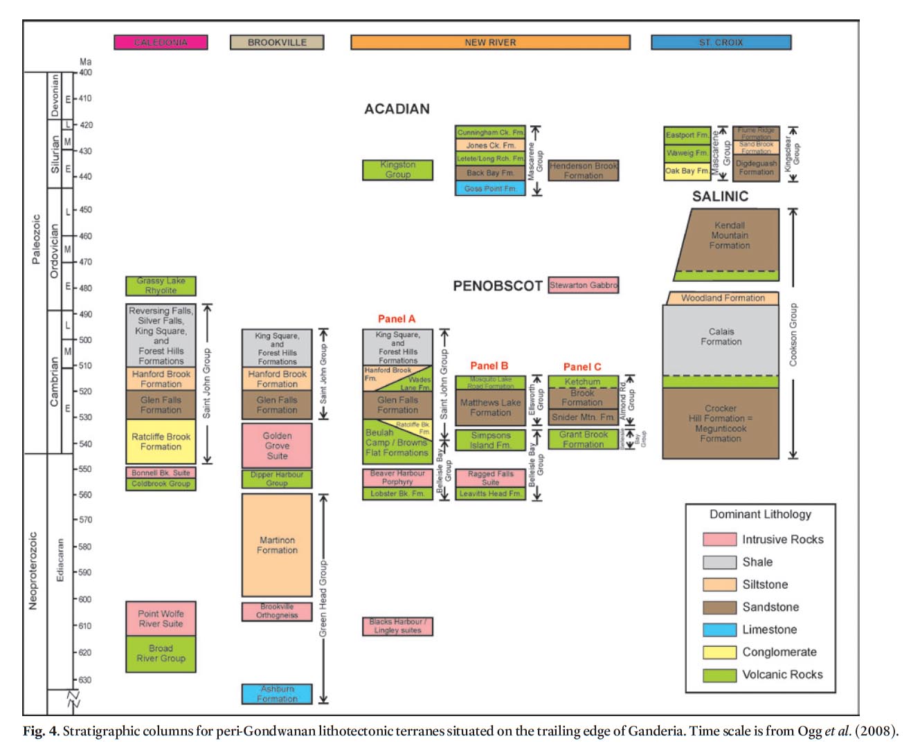 Display large image of Figure 4
 Display large image of Figure 5
Caledonia terrane
12 Neoproterozoic rocks of the Caledonia terrane are divided into the Broad River Group and Coldbrook Group. The Broad River Group comprises mainly intermediate to felsic crystal tuffs, lithic-crystal tuffs, and tuffaceous sedimentary rocks associated with comagmatic plutonic rocks (Point Wolfe River Suite) that range in age from 625 ± 5 Ma to 616 ± 3 Ma. The Coldbrook Group consists of intermediate to felsic lithic tuffs, crystal tuffs, flows and laminated tuffaceous siltstone, associated with comagmatic plutons (Bonnell Brook Suite) that range in age from 557 ± 3 Ma to 550 ± 1 Ma (Bevier et al. 1990; Barr et al. 1994; Whalen et al. 1994a; Barr and White 1996a, b; Barr and Kerr 1997; Barr and White 1999) (Fig. 4). Volcanic rocks of both the Broad River and Coldbrook groups are interpreted on the basis of geochemistry to have formed in an ensialic magmatic arc setting (Currie and Eby 1990; Barr and White 1996a), although an extensional setting is also proposed for the latter (Barr and White 1996b). They are similar in age and tectonic setting to those on the trailing edge of Ganderia (Brookville and New River terranes) but are isotopically less evolved (Whalen et al. 1994a, 1996a; Barr et al. 1998; Samson et al. 2000).
13 Cambrian to Lower Ordovician platformal sedimentary strata of the Saint John Group (Fig. 4) overlie the basement rocks of the Caledonia terrane (McLeod and McCutcheon 1981; Pickerill and Tanoli 1985; Tanoli et al. 1985; Tanoli and Pickerill 1987, 1988, 1989, 1990; Landing 1996a; Landing et al. 1998; Palacios et al. 2011). A U-Pb zircon date of 479 ± 8 Ma was obtained from the Grassy Lake Rhyolite, a subvolcanic dome in the Caledonia terrane (Barr et al. 1994). This may record an Early Ordovician time for the departure of Avalonia from Gondwana during expansion of the Rheic Ocean (van Staal et al. 2009; van Staal and Barr in press). However, others have considered separation from Gondwana to have occurred much earlier in the Cambrian (Landing and MacGabhann 2010, and references therein).
Brookville terrane
14 Basement rocks of the Brookville terrane comprise the Green Head Group, Brookville Gneiss, Dipper Harbour Group, and Golden Grove Plutonic Suite (Fig. 4). The Mesoproterozoic to Neoproterozoic platformal rocks of the Green Head Group include stromatolitic marble and lesser quartzose sandstone of the Ashburn Formation; and discordantly overlying silt-stone, quartzose sandstone, quartzite pebble conglomerate, and marble breccia of the Martinon Formation. Both of these formations represent older passive-margin sequences unrelated to Iapetus closure (Hofmann 1974; Nance 1987; Currie 1991; White and Barr 1996). The Ashburn and Martinon formations cannot be older than 1.23 ± 0.003 Ga and 602 ± 8 Ma, respectively, according to their youngest contained detrital zircon populations (Barr et al. 2003c; Fyffe et al. 2009). The Brookville Gneiss, a unit of paragneiss and orthogneiss, is in sheared contact with the Green Head Group; the orthogneiss yielded a U-Pb zircon date of 605 ± 3 Ma (Bevier et al. 1990; Dallmeyer et al. 1990).
15 Rhyolite flows and crystal tuffs of the Dipper Harbour Group, which yielded a U-Pb zircon date of 553 ± 3 Ma, occur in a fault panel that was thrust over Green Head carbonate strata along the coast of the Bay of Fundy (Currie and McNicoll 1999; White et al. 2002; Barr et al. 2003a). Plutonic rocks of the Golden Grove Suite, intruded into the Green Head Group, range in age from 548 ± 2 Ma to 528 + 1/-3 Ma (Neoproterozoic to Early Cambrian) and possess mainly calc-alkaline, continental arc geochemical signatures (Whalen et al. 1994a; Eby and Currie 1996; White and Barr 1996; Currie and McNicoll 1999; White et al. 2002; Barr et al. 2003a).
16 Cambrian platformal sedimentary rocks of the Glen Falls Formation, historically included in the Saint John Group, over-lie the basement rocks of the Brookville terrane along Kennebecasis Bay (Figs. 3, 4). The contacts with basement are always faulted to some degree. Basal conglomerate beds of the Ratcliffe Brook Formation are characteristic of the Caledonia terrane but are lacking in the Brookville sections (Hayes and Howell 1937; Westrop and Landing 2000).
New River terrane
17 The New River terrane is the most outboard of the Proterozoic terranes with respect to the Iapetus Ocean and the only one known to contain remnant elements of a Penobscot subduction-related magmatic system. It was previously referred to as the Mascarene terrane by Fyffe and Fricker (1987), because the nature of the basement rocks beneath the Silurian Mascarene cover was poorly known at the time (Hay 1968; Rast and Currie 1976). Basement rocks of the New River terrane trend toward coastal Maine, where they may underlie Penobscot volcanic rocks of the Ellsworth terrane (Stewart et al. 1995; Fyffe et al. 2009). The Ellsworth and New River terranes are cut internally by multiple faults constituting a large dextral transcurrent fault system that includes Acadian strike-slip duplexes of Late Silurian to Early Devonian age (Leger and Williams 1986; West et al. 1992, 1995; Stewart et al. 1995; Hibbard et al. 2006; Lin et al. 2007; van Staal et al. 2009).
18 The geology of the internally faulted New River terrane varies considerably along and across strike, as shown by Johnson and McLeod (1996), Johnson (2001), and Johnson et al. (2009). Extensive surface exposures of New River basement rocks occur in three fault panels marked as A, B, and C on Figure 3. Panel A is bounded to the southeast by the Belleisle-Beaver Harbour Fault, and northwest by the Letang Harbour and Robin Hood faults. Panel B is bounded to the southeast by the Letang Harbour, Belleisle-Beaver Harbour and Robin Hood faults, and northwest by the Wheaton Brook-Back Bay Fault. Panel C is bounded to the south by the St. George-Fanning Brook Fault and to the north by the Falls Brook-Taylor Brook Fault. The Turtle Head-Pendar Brook Fault defines the southern limit of the Paleozoic sedimentary rocks of the St. Croix terrane beneath the Saint George Batholith, and it transects the older Falls Brook-Taylor Brook Fault, which defines the northern limit of the New River terrane in this area (Fig. 3).
19 The region between the Wheaton Brook-Back Bay Fault and St. George-Fanning Brook Fault is covered largely by Silurian volcanic rocks of the Mascarene Basin. Gravity modelling by Thomas and Willis (1989) indicated that this cover is relatively thin, an interpretation supported by the presence of basement rocks in a fault sliver along the St. George-Fanning Brook Fault to the east of Passamaquoddy Bay (Fig. 3). The dark red and green sandstone and shale comprising this sliver correlates with the Upper Neoproterozoic to Cambrian Grant Brook Formation of the Belleisle Bay Group (see below).
20 Significant movement along the St. George-Fanning Brook Fault must have ceased by the Middle Silurian (Wenlockian), as it is intruded by the Utopia Granite, which yielded a U-Pb zircon date of 428 ± 1 Ma (Barr et al. 2010) and thus is the oldest pluton within the Saint George Batholith (Fig. 3). Later reactivation of the St. George-Fanning Brook Fault is indicated by movement on the Perry Fault, which lies to the north in the footwall of the former fault. The Perry Fault has thrust volcanic rocks of the Silurian Mascarene Group over conglomerate of the Upper Devonian Perry Formation, indicating that fault movement in this area continued into the Carboniferous (Schluger 1973, 1976; Donohoe 1978).
Panel A
21 The oldest rocks in the New River terrane occur in Panel A (Fig. 3) where, in the Long Reach area, they belong to the Lingley Plutonic Suite (Johnson 2001; Johnson and Barr 2004). The Lingley suite comprises granodiorite, tonalite, and quartz diorite along with red leucogranite and quartz-feldspar porphyry (Currie 1987; Johnson 2001). Neoproterozoic U-Pb zircon dates of 625 ± 2 Ma and 629 ± 1.0 Ma have been obtained from the granodioritic and granitic phases, respectively (Currie and McNicoll 1999).
22 Stratified basement rocks in the Long Reach area are assigned to the Lobster Brook, Browns Flat, and Beulah Camp formations of the Upper Neoproterozoic to Lower Cambrian Belleisle Bay Group (Fig. 4). The Lobster Brook Formation comprises extrusive and high-level intrusive rocks, including flow-banded ash tuff, rhyolite flows and agglomerate, felsic lithic-crystal tuff, and minor microgranite porphyry. A rhyolitic tuff from Gorhams Bluff (Fig. 3) yielded a Neoproterozoic U-Pb zircon date of 554 ± 6 Ma (Johnson 2001; McLeod et al. 2003), demonstrating that the Lobster Brook Formation is considerably younger than the Lingley Plutonic Suite with which it is in fault contact.
23 The Browns Flat Formation consists of basaltic flows, tuff, and red and grey sandstone and siltstone. The basaltic rocks have geochemical signatures ranging from arc to within-plate tholeiites (Greenough et al. 1985; Johnson and Barr 2004). The Beulah Camp Formation consists mainly of dacitic pyroclastic rocks, and lies immediately below grey sandstone of the Lower Cambrian Hanford Brook Formation (Saint John Group) on Gorhams Bluff (Figs. 3, 4). Thus, the Beulah Camp Formation appears to occur higher in the stratigraphic section than the Browns Flat Formation and to be Early Cambrian or possibly latest Neoproterozoic in age (McCutcheon 1981; Greenough et al. 1985; Landing and Westrop 1996; Johnson 2001).
24 In the Beaver Harbour area of Panel A (Fig. 3), the New River terrane is composed largely of the Blacks Harbour Granite (Fig. 4), which yielded a U-Pb zircon date of 622 ± 2 Ma, essentially the same age as the Lingley Suite (Barr et al. 2003a; Bartsch and Barr 2005). The Blacks Harbour Granite is faulted to the south against the upper part of an interbedded shallow-water sedimentary and volcanic sequence along Buckmans Creek on the north shore of Beaver Harbour (Fig. 3). These rocks are included in the Saint John Group and comprise: (1) a lower section of conglomerate and quartzose sandstone that are correlated with the Ratcliffe Brook and Glen Falls formations, respectively, of the type area of the Saint John Group; (2) a middle section of basaltic rocks, red siltstone, and minor limestone referred to as the Wades Lane Formation; and (3) an upper section of pyritiferous shale and limestone correlated with the Forest Hills Formation of the type area of the Saint John Group (Greenough et al. 1985; Johnson 2001; Landing et al. 2008).
25 Lower to Middle Cambrian trilobites occur in limestone beds in the middle and upper sections (Helmstaedt 1968; Landing et al. 2008). The basaltic rocks have an evolved, continental tholeiitic geochemical signature (Greenough et al. 1985). The contact between the Ratcliffe Brook conglomerate and structurally underlying Beaver Harbour Porphyry (Bartsch and Barr 2005; Landing et al. 2008) at the southern end of the Buckmans Creek section is apparently faulted, but large clasts of porphyry in the conglomerate suggest that displacement along the contact is probably not significant (Fig. 4).
Panel B
26 The New River terrane in Panel B (Fig. 3) is composed mainly of the Neoproterozoic Ragged Falls Granite (Fig. 4), which yielded a U-Pb zircon date of 553 ± 2 Ma (Currie and Hunt 1991; Johnson and McLeod 1996; Johnson 2001; McLeod et al. 2003). Comagmatic felsic volcanic host rocks from the Leavitts Head Formation of the Belleisle Bay Group yielded a U-Pb zircon date of 554 ± 3 Ma (McLeod et al. 2003). The Simpsons Island Formation (Belleisle Bay Group), comprising a sequence of felsic and mafic volcanic rocks and arkosic sandstone, lies along the southern margin of the Ragged Falls Granite just north of the Letang Harbour Fault (Fig. 3) (McLeod 1995; Johnson and McLeod 1996; Johnson 2001; McLeod et al. 2001). The Simpsons Island sequence yielded a U-Pb zircon date of 539 ± 4 Ma or earliest Cambrian (Barr et al. 2003a; Bartsch and Barr 2005).
27 Cambrian volcanic and sedimentary sequences along the northern margin of the Ragged Falls Granite are included in the Ellsworth Group in New Brunswick (Fig. 4), as they are similar in geological character but about 5 Ma older than the ‘Ellsworth Schist’ (see below), the original term used for the oldest Penob-scot-aged rocks known in Maine (Schultz et al. 2008; Fyffe et al. 2009). The Ellsworth Group in New Brunswick consists of quartzose sandstone and intraformational quartzite-pebble conglomerate of the Matthews Lake Formation; and overlying felsic flows and breccia, iron-rich tuff, and volcaniclastic sandstone of Mosquito Lake Road Formation. Rhyolite breccia in the upper part of the Mosquito Lake Road Formation yielded a late Early Cambrian U-Pb zircon date of 514 ± 2 Ma (Johnson and McLeod 1996; Johnson 2001; McLeod et al. 2003). The volcanic rocks of the Mosquito Lake Road Formation range in composition from andesite to rhyolite and possess an arc geo-chemical signature (Johnson and McLeod 1996). They thus represent the oldest known part of the Penosbcot arc system preserved in the New England and Maritime Appalachians.
Panel C
28 In Panel C, the Upper Neoproterozoic to lowest Cambrian strata are included in the Grant Brook Formation of the Belleisle Bay Group (Johnson et al. 2009). Separate formational status within the Belleisle Bay Group was assigned to these rocks because of their greater abundance of sedimentary versus pyroclastic rocks compared with other units in the group (Fig. 4). The Grant Brook Formation comprises thin- to medium-bedded, dark red and green siltstone and shale; medium- to thick-bedded micaceous wacke; intermediate to felsic pyroclastic and volcaniclastic rocks; and lesser mafic flows (Johnson et al. 2009; McLeod 1997; McCutcheon and Ruitenberg 1987). A slightly reworked intermediate tuff in the vicinity of The Grant (Fig. 3) yielded an earliest Cambrian U-Pb zircon date of 541 ± 3 Ma (Johnson et al. 2009), essentially identical to the age of the felsic volcanic rocks dated at 539 ± 4 Ma from the Simpsons Island Formation (Belleisle Bay Group) in Panel B (Barr et al. 2003a).
29 Younger Cambrian to possibly Lower Ordovician rocks over-lying the Grant Brook Formation in Panel C are included in the Almond Road Group. The lower part of the section comprises orthoquartzite and quartzite-pebble conglomerate of the Snider Mountain Formation; and the upper part includes light grey quartzose sandstone, dark grey shale, and mafic volcanic rocks of the Ketchum Brook Formation (Johnson et al. 2009). The Ketchum Brook Formation is no younger than the cross-cutting West Scotch Settlement Porphyry, which yielded an Early Ordovician (Floian) U-Pb zircon date of 475 ± 2 Ma (S.C. Johnson, unpublished data). We propose that the Almond Road Group correlates with the Matthews Lake Formation of the Ellsworth Group in Panel B (Fig. 4). The presence of these quartz-rich sedimentary rocks across the region from Panel A in the southwest to Panel C in the northeast suggests that Neoproterozoic to earliest Cambrian arc activity on Gondwana was followed by a period of magmatic quiescence and deposition of an Early Paleozoic passive-margin sequence (Rogers et al. 2006).
30 Gravity modelling indicates that, in the Passamaquoddy Bay area of New Brunswick (Fig. 3), New River basement rocks of Panel C extend beneath the Silurian rocks of the Mascarene Group and beneath the Saint George Batholith as far north as the Turtle Head-Pendar Brook Fault (Thomas and Willis 1989; Whalen et al. 1996a; Fyffe et al. 1999; King and Barr 2004). Although basement rocks are concealed beneath Mascarene cover in the Passamaquoddy Bay area, the apparent westward continuation of Panel C into the Penobscot Bay area of Maine is overlain only in part by Silurian volcanic rocks. These older volcanic sequences exposed along the Maine coast are referred to as the Ellsworth Schist and Castine Volcanics (Stewart and Wones 1974; Stewart et al. 1995; Schultz et al. 2008). A felsic tuff of the Ellsworth Schist and a felsic dome in the Castine Volcanics yielded Middle Cambrian U-Pb zircon dates of 509 ± 1 Ma and 504 ± 3 Ma, respectively (Ruitenberg et al. 1993; Schultz et al. 2008). These volcanic rocks are therefore somewhat younger than those of the Mosquito Lake Road Formation, which were dated at 514 ± 2 Ma in Panel B (Fig. 3).
31 The total age range of the Ellsworth volcanic rocks in New Brunswick and Maine (514 ± 2 Ma to 504 ± 3 Ma) is comparable with that of the older Penobscot volcanic arc sequences (513 ± 2 Ma to 506 ± 3 Ma) in the Victoria Lake Supergroup of central Newfoundland (Dunning et al. 1991; Rogers et al. 2006; Zagorevski et al. 2007, 2010). The rocks of both the Ellsworth and Castine volcanic sequences in Maine are composed of bimodal basalt-rhyolite assemblages that formed in an extensional marine tectonic setting (Schultz et al. 2008). As in Newfoundland, this change from an arc setting for the upper Lower Cambrian volcanic rocks (Mosquito Lake Road Formation) to an extensional setting for those of the Middle Cambrian (Ellsworth Schist and Castine Volcanics) may be related to northwestward retreat of a subduction zone dipping beneath the leading edge of Ganderia (Rogers et al. 2006; Zagorevski et al. 2007, 2010).
EARLY PALEOZOIC TERRANES
32 Early Paleozoic terranes can be divided into two groups: (1) the St. Croix, Annidale, and Miramichi terranes in southern and northern New Brunswick, all of which have some preserved evidence of Cambrian to Early Ordovician (Tremadocian) Penobscot arc-backarc volcanism as well of a younger period of Early to Late Ordovician (Floian to Sandbian) volcanism; and (2) the Elmtree and Popelogan terranes in northern New Brunswick, which contain ophiolitic and arc rocks that are exclusively Middle to Late Ordovician (Darriwilian to Sandbian) and thus postdate the formation of terranes containing Penobscot volcanic sequences.
St. Croix terrane
33 The St. Croix terrane is composed of the Cookson Group, a thick sequence of Cambrian to Upper Ordovician quartz-rich sandstone and shale that was deposited along the continental margin of Gondwana (Ruitenberg and Ludman 1978; Ludman 1987, 1991; Fyffe and Riva 1990). The Cookson Group is separated from its assumed Neoproterozoic and earliest Cambrian basement rocks of the New River terrane to the south by covering rocks of the Lower Silurian Oak Bay and Waweig formations of the Mascarene Basin (Figs. 3, 4). Thick-bedded quartzose sandstone of the Crocker Hill Formation, containing pods of pink garnet, forms the base of the Cookson sequence and correlates with the Megunticook Formation in the Penobscot Bay area of Maine (Tucker et al. 2001). Overlying carbonaceous black shale of the Calais Formation is intercalated with minor thin beds of silty sandstone and contains a unit of pillow basalt at its base. The nature of the contact between the basalt and quartzose sandstone of the underlying Crocker Hill Formation cannot be determined with certainty as it is folded and transected by northerly directed thrust faults, but the contact itself does not appear to be significantly sheared (Fyffe 2005).
34 A sequence of thin- to medium-bedded feldspathic wacke, siltstone, and shale of the Woodland Formation overlies the Calais Formation and locally contains large calcareous concretions. The Woodland Formation is, in turn, overlain by medium- to thick-bedded quartzose sandstone and carbonaceous shale of the Kendall Mountain Formation. The occurrence of a Penobscot stratigraphic break in the Cookson Group is suggested by the presence of quartz-pebble conglomerate lenses at the base of the Kendall Mountain Formation (Fig. 4). Graptolites from black shale in these units indicate that the Calais Formation is as young as Early Ordovician (Tremadocian) and that the Kendall Mountain Formation is Late Ordovician (Sand-bian) (Fyffe and Riva 1990).
35 The boundary between the St. Croix and New River terranes is not exposed in New Brunswick but can be observed in Maine. There, the Turtle Head Fault separates the Ellsworth Schist of the New River (Ellsworth) terrane from Lower Paleozoic black shale (Penobscot Formation) of the St. Croix terrane. This fault is a steep structure that underwent mainly dextral transcurrent movement during Acadian orogenesis (Stewart et al. 1995; van Staal et al. 2009). The continuation of the Turtle Head Fault into New Brunswick has been obscured by the intrusion of the Saint George Batholith (Fig. 3). Translation along this fault must have largely ceased by the Early Devonian, because it is cut by the Magaguadavic Granite of the Saint George Batholith, which yielded U-Pb zircon dates of 403 ± 2 Ma and 396 ± 1 Ma (Bevier 1990; Davis et al. 2004).
36 Gravity modelling indicates that sedimentary rocks of the Cookson Group extend under Silurian cover rocks as far south as the buried Turtle Head Fault (Fyffe et al. 1999; King and Barr 2004). These Cookson strata pinch out eastward beneath the Saint George Batholith and therefore are not observed along the Pendar Brook Fault, which represents the extension of the Turtle Head Fault (Fig. 3) to the east of the batholith (McCutcheon 1981; McCutcheon and Ruitenberg 1987; McLeod 1990).
Annidale terrane
37 The Annidale terrane is faulted to the south against Neoproterozoic to lowest Cambrian rocks (Grant Brook Formation) of the New River terrane along the Falls Brook-Taylor Brook Fault and to the north against Silurian rocks of the Fredericton Trough along the Turtle Head-Pendar Brook Fault (Fig. 3). Its extent farther to the northeast is obscured by a cover of Carboniferous sandstone, but an isolated gravity high in a profile across the region (Thomas and Willis 1989, their profile P-P’) suggests that the Annidale terrane is preserved only as a relatively small sliver bounded by these two faults.
38 The Annidale terrane is composed of three main thrust panels that have disrupted the stratigraphic relationships within the Annidale Group. However, each panel preserves at least some of the original contacts between rock units so that reconstruction of the whole stratigraphic section can be determined with reasonable certainty (Fig. 5). The most northerly thrust panel exposed within the Annidale terrane comprises rocks of the Lawson Brook Formation. They consist of a thick succession of dominantly pillowed mafic flows, black shale, and greyish green siltstone that have been intruded by massive, grey to black, flow-banded, feldspar-phyric, subvolcanic felsic domes (Johnson et al. 2009). These volcanic domes bear a striking resemblance to those in the Middle Cambrian Castine Volcanics (504 ± 3 Ma) of coastal Maine, but a U-Pb zircon date on one of the Lawson Brook domes yielded a younger Late Cambrian age of 493 ± 2 Ma (McLeod et al. 1992; Ruitenberg et al. 1993). Highly strained schistose felsic and mafic rocks, which are thought to represent a deep structural level of the Lawson Brook Formation, are exposed farther north in a small inlier surrounded by Carboniferous strata. Felsic rocks within this highly strained unit yielded igneous zircons that gave a U-Pb date of 497 ± 10 Ma (McLeod et al. 1992) and an 40Ar/39Ar date of 444 ± 5 Ma on metamorphic muscovite (Johnson et al. 2009).
39 The second, middle panel consists of coarse- and fine-grained facies of the Carpenter Brook Formation. The coarse-grained facies contains intercalated, medium-bedded, greyish green and maroon quartzose sandstone, siltstone, lesser felsic tuffs, spherulitic rhyolite flows and associated rhyolite domes, and thick-bedded, coarse-grained feldspar-rich volcaniclastic rocks. This facies grades laterally to the south into a fine-grained, deeper water, distal facies of grey, thin-bedded silty sandstone, siltstone, and shale. The northward increase in bed thickness and grain size of the volcaniclastic rocks suggests that the Carpenter Brook sequence was sourced from a submarine pyroclastic apron (see Busby 1998) deposited on the margin of a volcanic arc edifice, represented by the Lawson Brook Formation. The Carpenter Brook Formation is no younger than Late Cambrian, because it is cut by the highly deformed Cameron Road Granite, which yielded a U-Pb zircon date of 490 ± 2 Ma. Nor can it be older than 552 ± 2 Ma, according to its youngest contained detrital zircon population (Johnson et al. 2009).
40 The third, southernmost thrust panel in the Annidale Group consists of the East Scotch Settlement Formation and a domal complex referred to as the London Settlement Rhyolite (Fig. 5). The East Scotch Settlement Formation contains interbedded dark grey to carbonaceous black shale, mafic agglomeratic debris flows, picritic tuffs, and fuchsite-altered hyaloclastic tuffs. The black shale locally occurs as a mélange containing disrupted beds and blocks of sandstone. The East Scotch Settlement Formation is no younger than Tremadocian (Early Ordovician), as it is intruded by the weakly foliated Henderson Settlement Plagiogranite, which yielded a U-Pb zircon date of 482 ± 2 Ma (Johnson et al. 2009), and by the Daley Brook Plagiogranite, which yielded a U-Pb zircon date of 481 ± 2 Ma (S.C. Johnson, unpublished data).
41 Isolated outcrops of pebble to cobble conglomerate along the northern boundary of the southernmost thrust panel lie between Carpenter Brook strata to the north and the London Settlement Rhyolite exposed just to the south. The conglomerate contains angular to rounded sedimentary clasts, clearly derived from the Carpenter Brook Formation, limestone clasts of unknown origin, and rare felsic clasts set in a mudstone matrix. We interpret the conglomerate to represent a debris flow deposited during uplift related to the emplacement of the London Settlement domal complex, which intrudes mafic volcanic rocks of the East Scotch Settlement Formation. The London Settlement Rhyolite is characterized by the presence of volcanic autobreccia containing pink fragments of quartz-feldsparphyric rhyolite set in a black glassy matrix. Spherulitic rhyolite from the dome yielded a late Early Ordovician (Floian) U-Pb zircon date of 478 ± 2 Ma. This younger magmatism continued into the Middle Ordovician (Darriwilian), as indicated by a U-Pb zircon date of 467 ± 3 Ma on the Bull Moose Hill Porphyry, which intrudes the Grant Brook Formation of the New River terrane (Johnson et al. 2009).
42 Most mafic volcanic rocks in the Lawson Brook and East Scotch Settlement formations range in composition from tholeiitic basalt to basaltic andesites depleted in Nb and enriched in light rare earth elements. The picritic tuffs in the East Scotch Settlement Formation exhibit high MgO, Cr, and Ni, and low TiO2 values, marked depletion in light rare earth elements, and non-depletion in Nb. The presence of basalts and basaltic andesites in the Annidale Group with both depleted and non-depleted Nb signatures is characteristic of mafic volcanic rocks erupted in an arc-backarc setting (McLeod et al. 1994; Johnson et al. 2009). The age range of volcanic rocks in the Annidale Group (493 ± 2 Ma to 481 ± 2 Ma) is comparable to that of the younger Penobscot volcanic arc sequences (497 ± 2 Ma to 487 ± 3 Ma) in the Victoria Lake Supergroup of central Newfoundland (Dunning et al. 1991; Rogers et al. 2006; Zagorevski et al. 2007, 2010).
Miramichi terrane
43 The Miramichi terrane underlies the Miramichi Highlands, the axial region of New Brunswick that extends from Bathurst in the northeast to Woodstock in the southwest (Fig. 2). The highly deformed Cambrian to Ordovician sedimentary and volcanic strata that define this terrane are intruded by numerous plutons of Middle Ordovician and Late Silurian to Middle Devonian age (Fyffe et al. 1977, 1981; Fyffe and Cormier 1979; Fyffe 1982; Fyffe et al. 1988b; Whalen et al. 1996b, 1998). The geological characteristics of the Miramichi Highlands as a whole resemble those of both the Gander Zone and Exploits Subzone of Newfoundland (Rast et al. 1976; van Staal and Fyffe 1991, 1995). The southeastern boundary of the Miramichi terrane with the Fredericton Trough is marked by the Bamford Brook-Hainesville Fault. Its northwestern boundary with the Matapédia Basin is delineated by a fault (Catamaran-Woodstock Fault) in the south and an unconformity with the over-lying Chaleurs and Tobique groups in the north (Figs. 2, 5).
44 The Miramichi terrane in the Bathurst area (Fig. 2) is characterized by a Cambrian to Lower Ordovician (Tremadocian) quartzose sedimentary sequence of the Miramichi Group, and unconformably to conformably overlying Middle to Upper Ordovician (Dapingian to Sandbian) bimodal volcanic rocks of the Bathurst Supergroup (Helmstaedt 1971; Fyffe 1976, 1982; Whitehead and Goodfellow 1978; Neuman 1984; van Staal 1987; van Staal and Fyffe 1991, 1995; van Staal et al. 1991, 2003; Fyffe et al. 1997). The Miramichi Group is divided into a lower unit of thick-bedded quartzose sandstone of the Chain of Rocks Formation; a middle unit of medium-bedded quartzose sandstone, siltstone, and shale of the Knights Brook Formation; and an upper unit of medium-bedded, feldspathic sandstone and shale of the Patrick Brook Formation (Fig. 5).
45 The Bathurst Supergroup is divided into four, roughly coeval volcanosedimentary sequences (the Tetagouche, California Lake, Sheephouse Brook, and Fournier groups) that occupy separate thrust panels formed during Salinic orogenesis in the Silurian (van Staal et al. 2003, 2008). Stratigraphic relationships between the Middle to Upper Ordovician volcanosedimentary sequences of the Bathurst Supergroup and underlying Miramichi Group are best observed in the Tetagouche Group. The base of the Tetagouche Group is exposed near Tetagouche Falls on the Tetagouche River, where a thin unit of conglomerate, calcareous sandstone, and siltstone of the Vallée Lourdes Member of the Nepisiguit Falls Formation (Fig. 5) lies unconform-ably on the Patrick Brook Formation, which contains highly disrupted sandstone beds in a shaly matrix. This unconformity postdates deformation that transformed the Patrick Brook beds into a broken formation, suggesting a relationship to Penobscot orogenesis (Fig. 5). The Vallée Lourdes calcareous siltstone on the Tetagouche River and correlative limestone beds in central New Brunswick contain Middle Ordovician (Dapingian) brachiopods of the Celtic biogeographic province (Neuman 1968, 1971, 1984; Fyffe 1976; Nowlan 1981; Fyffe et al. 1997; Poole and Neuman 2003; Downey et al. 2006).
46 Volcanic rocks overlying the Middle Ordovician Vallée Lourdes Member are divided into a lower unit of quartz-feldspar crystal tuff and iron formation of the Nepisiguit Falls Formation; a middle unit of aphyric to sparsely feldspar-phyric felsic flows of the Flat Landing Brook Formation; and an upper unit of interbedded mafic volcanic rocks, ferromanganiferous cherty siltstone, and black shale of the Little River Formation (Fig. 5). On the basis of their stratigraphic relationships, geo-chemical composition, and structural history, the volcanic rocks of the Bathurst Supergroup are considered to have been generated initially in an ensialic intra-arc rift that eventually evolved into a wide oceanic basin referred to as the Tetagouche backarc basin (van Staal 1987, 1994; Paktunc 1990; van Staal and Fyffe 1991, 1995; van Staal et al. 1991, 2003; Winchester et al. 1992a).
47 The Miramichi terrane near Woodstock in west-central New Brunswick (Figs. 2, 5) consists of a quartzose sedimentary sequence and an overlying volcanic sequence, referred to as the Woodstock and Meductic groups, respectively (Fyffe 2001). The Woodstock Group includes quartzose sandstone and shale of the Baskahegan Lake Formation and conformably overlying carbonaceous black shale of the Bright Eye Brook Formation, and is a direct correlative of the Miramichi Group (Fig. 5). Trace fossils recovered from the Baskahegan Lake Formation near Woodstock may be as young as Early Ordovician (Pick-erill and Fyffe 1999). The formation cannot be older than Early Cambrian, according to the 525 ± 6 Ma date on its youngest contained zircon population (Fyffe et al. 2009). Graptolites recovered from the overlying Bright Eye Brook black shale are Early Ordovician (Tremadocian to Floian) in age (Fyffe et al. 1983).
48 The conformably overlying Meductic Group (Fig. 5) is divided into felsic volcanic flows and tuffs of the Porten Road Formation; intermediate tuffs and volcaniclastic rocks of the Eel River Formation; mafic volcanic flows and tuffs of the Oak Mountain Formation; and disconformably overlying feldspathic sandstone and shale of the Belle Lake Formation. Graptolites from the Belle Lake Formation are indicative of a Late Ordovician (Sandbian) age (Fyffe et al. 1983). Conodonts from strata that are possibly correlative with the Belle Lake Formation east of Woodstock gave a slightly older Middle Ordovician (Darriwilian) age (Venugopal 1979; Nowlan 1981).
49 The Gibson pluton in the Woodstock area yielded an Early Ordovician (Floian) U-Pb zircon date of 473 ± 1 Ma (Bevier 1990; Whalen 1993). The similar, nearby Benton pluton intrudes the Oak Mountain Formation and thus suggests that volcanic rocks of the Meductic Group are largely older than those of the Tetagouche Group, which yielded Middle to Late Ordovician (Dapingian to Sandbian) U-Pb zircon dates of 471 ± 3 Ma to 457 ± 1 Ma in the Bathurst area (Fig. 2) (Sullivan and van Staal 1996; van Staal et al. 2003). These age constraints also indicate that the Meductic volcanism was essentially contemporaneous with the London Settlement Rhyolite of the Annidale terrane.
50 The Meductic volcanic rocks possess geochemical characteristics consistent with an arc setting; therefore, they are interpreted to represent an arc that formed above a subduction zone dipping to the southeast beneath the leading edge of Ganderia (Dostal 1989; Fyffe and Swinden 1991; van Staal and Fyffe 1991, 1995; Fyffe 2001). The disconformity at the base of the Belle Lake Formation (Fig. 5) marks the time that Meductic volcanic activity ceased and the arc became a dormant remnant left stranded on the passive side of the Tetagouche backarc basin (van Staal and Fyffe 1991, 1995). A series of tholeiitic mafic dykes intrude the sedimentary rocks of the Baskahegan Formation and may be related to the initial opening of this backarc basin (David et al. 1991).
Elmtree terrane
51 The Elmtree terrane occurs north of the Miramichi terrane as a small inlier surrounded by Silurian rocks of the Chaleurs Group and is composed primarily of ophiolitic rocks of the Fournier Group. Rocks correlated with the Fournier Group also occur in the Bathurst Supergroup of the Miramichi terrane (Fig. 5), indicating a close tectonic linkage between the two terranes. The Fournier Group in the inlier includes coarse-grained, locally layered gabbro, mylonitic amphibolite, plagiogranite, diabase dykes (locally defining a sheeted complex), and pillow basalt, all of which are included in the Devereaux Formation (Parjari et al. 1977). The ophiolitic assemblage is structurally underlain by oceanic basalt, wacke, and shale (locally transformed into a mélange) of the Pointe Verte Formation (Rast and Stringer 1980; Flagler and Spray 1991; van Staal and Fyffe 1991, 1995; Winchester et al. 1992b). Gabbro from the Devereaux Formation yielded a Middle Ordovician (Darriwilian) U-Pb zircon date of 464 ± 1 Ma; plagiogranite intruding the gabbro yielded zircon dates of 461 +3/-2 Ma and 460 ± 3 Ma (Spray et al. 1990; Sullivan et al. 1990). Conodonts and graptolites from the Pointe Verte Formation range in age from Middle to Late Ordovician (Darriwilian to Sandbian) (Nowlan 1983a; Fyffe 1986). The Devereaux and Pointe Verte formations are separated by a tectonic mélange containing large ultramafic knockers from a structurally underlying sequence of wacke, shale, and minor basalt of the Elmtree Formation (Winchester et al. 1992b; van Staal et al. 2003). Graptolites from Elmtree black shale are Middle to Late Ordovician (Darriwilian to Sandbian) in age (McCutcheon et al. 1995).
52 The ophiolitic assemblage of the Fournier Group was interpreted first as a fragment of normal Iapetus oceanic crust (Pajari et al. 1977; Rast and Stringer 1980) and later as oceanic crust that formed during the opening and spreading of the Tetagouche backarc basin in the Middle Ordovician (van Staal 1987; Flagler and Spray 1991; van Staal and Fyffe 1991, 1995; Winchester et al. 1992b). As such, it postdates the generation of already obducted Penobscot ophiolites that form part of the Exploits Subzone in central Newfoundland and that structurally overlie sedimentary rocks of the Gander Group (Colman-Sadd and Swinden 1984). Uplift of the Elmtree terrane prior to the late Early Silurian is indicated by the presence of basal, late Llandoverian conglomerate of the Weir Formation (Chaleurs Group) that sits unconformably on Middle Ordovician gabbroic rocks of the Fournier Group (Noble 1976; Nowlan 1983b).
Popelogan terrane
53 The Balmoral Group, which constitutes the exposed part of the Popelogan terrane, is located in a small north-northeasterly trending anticlinal inlier within the Matapédia Basin (see section on ‘Cover Sequences’ below) about 30 km south of Camp-bellton in northern New Brunswick (Fig. 2). The lower, likely Middle Ordovician part of the Balmoral Group contains mafic lapilli tuff and agglomerate with abundant carbonate cement, and massive to amygdaloidal, plagioclase-phyric mafic flows of the Goulette Brook Formation. These rocks are conformably overlain by carbonaceous black shale and chert of the Popelogan Formation, which contain graptolites that are Late Ordovician (Sandbian) in age (Fig. 5) (Philpott 1987, 1988; Irrinki 1990; van Staal and Fyffe 1991, 1995; Wilson 2000). The Bal-moral Group is overlain disconformably to unconformably by calcareous grit of the White Head Formation, which has been dated by conodonts just above the contact as late Late Ordovician (Hirnantian) (Wilson et al. 2004).
54 The mafic volcanic rocks of the Goulette Brook Formation range in composition from picrites (containing up to 27% MgO and 2000 ppm Cr) to MgO-rich and MgO-poor andesites, all with a volcanic arc signature (Philpott 1988; Wilson 2003). The Popelogan terrane is interpreted to represent an active arc that rifted from the remnant Meductic arc of the Miramichi terrane and migrated to the northwest during the opening of the Tetagouche backarc basin (van Staal and Fyffe 1991, 1995).
55 A possible southwestern extension of the Popelogan terrane is exposed in a small inlier within the Matapédia Basin along Markey Brook (MK on Fig. 2) to the northeast of Woodstock. The inlier comprises Middle to Upper Ordovician (Darriwilian to Sandbian) nodular and crystalline limestone, quartzose sandstone and chert of the Craig Brook Formation, overlain unconformably by Upper Ordovician (Hirnantian) limestone pebble conglomerate and sandy limestone (St. Peter 1982; Nowlan et al. 1997) (Fig. 5). We interpret the Craig Brook strata to represent a shallow-water carbonate facies that was deposited adjacent to the active Popelogan arc after it had rifted from the remnant Meductic arc.
COVER SEQUENCES
56 The term ‘cover sequence’ is used herein to include strata deposited in a variety of successor basins developed on Ganderia that were infilled mainly after Early Paleozoic volcanic arc activity related to closure of the main tract of the Iapetus Ocean had ceased. The early depositional stages of some basins may have been syntectonic with respect to terrane accretion and closure of Iapetus marginal basins. Cover sequences include those deposited in the Early Silurian Kingston Basin, the Late Ordovician to Late Silurian Mascarene Basin, the Silurian Fredericton Trough, and the Late Ordovician to Early Devonian Matapédia Basin. Also included as cover sequences are Late Devonian to Pennslyvanian strata of the Maritimes Basin and the Triassic Fundy Basin.
Kingston Basin
57 The highly sheared volcanic rocks within the Kingston Basin, which separates basement rocks of the Brookville terrane from those of the New River terrane, were originally considered to be Precambrian (Rast 1979; Rast and Dickson 1982; Currie 1984; Nance 1987; McLeod and Rast 1988). However, recent U-Pb zircon dating yielded Early Silurian (Llandoverian) ages of 436 ± 3 Ma, 437 ± 3 Ma, and 442 ± 6 Ma on felsic volcanic rocks of the Kingston Group, and 436 ± 2 Ma, 435 ± 5 Ma, and 437 ± 10 Ma on comagmatic felsic plutons and dykes (Doig et al. 1990; Barr et al. 2002; McLeod et al. 2003). The Silurian Kingston Group is divided into several formations (Barr et al. 2002) and is interpreted on the basis of geochemical and paleogeographical considerations to represent a volcanic arc that formed above a subduction zone dipping to the northwest beneath the New River terrane (Fyffe et al. 1999; Barr et al. 2002; White et al. 2006).
Mascarene Basin
58 The Mascarene Basin contains Upper Ordovician to Upper Silurian volcanic and sedimentary rocks of the Mascarene Group (Fyffe et al. 1999). Strata of the Mascarene Group overstep the boundary between the Cambrian to Ordovician St. Croix terrane to the north and the Neoproterozoic New River terrane to the south (King and Barr 2004) . The northern boundary of the Mascarene Basin is marked by the Sawyer Brook Fault (Fig. 3). Dextral movement along this fault has juxtaposed the basal conglomerate of the Lower Silurian Oak Bay Formation against polydeformed Lower Ordovician black shale of the Calais Formation at Oak Bay and against Upper Ordovician quartzose sandstone of the Kendall Mountain Formation along strike to the northeast (Figs. 3, 4) (Ruitenberg and Ludman 1978; Gates 1989; Fyffe et al. 1999; Park et al. 2008; Thorne et al. 2008).
59 The faulted, angular unconformity between the Oak Bay and Calais formations marks the initiation of oblique rifting and opening of the Mascarene Basin (Fyffe et al. 1999). The conglomerate contains clasts of black shale and quartzite of clearly local origin but also contains abundant igneous clasts of Neoproterozoic age that were likely derived from the New River terrane, although such rocks are not exposed in the Oak Bay area (Fyffe et al. 2009). Southward into the basin, away from the highly strained zone marked by the Sawyer Brook Fault, conglomerate of the Oak Bay Formation can be observed lying with preserved unconformity on polydeformed shale of the Calais Formation.
60 In the Oak Bay area north of the Saint George Batholith (Figs. 3, 4), conglomerate of the Oak Bay Formation along the northern boundary of the Mascarene Basin is conformably overlain by light pink, fine-grained sandstone and siltstone; felsic crystal tuff; coarse-grained, volcaniclastic sandstone; and lesser mafic tuff and black shale of the Waweig Formation (Pick-erill 1976; Fyffe et al. 1999). A felsic tuff in the Waweig Formation yielded an Early Silurian (Llandoverian) U-Pb zircon date of 438 ± 4 Ma (Miller and Fyffe 2002). Gently south-dipping strata of the Mascarene Group lie along the southern margin of Saint George Batholith and north of the St. George Fault. They comprise an interbedded sequence of subaerial mafic and felsic flows, and red sandstone and siltstone of the Middle to Upper Silurian (Wenlockian to Ludlovian) Eastport Formation (Pickerill and Pajari 1976; Van Wagoner and Fay 1988; Van Wagoner et al. 1994). The southerly dipping Eastport volcanic sequence, which yielded a U-Pb zircon date of 423 ± 1 Ma (Van Wagoner et al. 2001), may well be conformable with the Waweig Formation (Fig. 4) along the northern side of the Saint George Batholith; if so, it would overstep the boundary between the St. Croix and New River terranes in the subsurface.
61 More complexly deformed, steeply dipping rocks of the Mascarene Group to the southeast of the St. George-Fanning Brook Fault include limestones of the Upper Ordovician Goss Point Formation, quartzose sandstone of the Lower Silurian Back Bay Formation, and felsic and mafic tuffs of the Letete Formation (Cumming 1967; Donohoe 1973, 1978; Johnson and McLeod 1996; Fyffe et al. 1999; McLeod et al. 2001). Felsic tuff in the Letete Formation yielded an Early Silurian (Llandoverian) U-Pb zircon date of 437 ± 7 Ma (Miller and Fyffe 2002), coeval with felsic volcanism in the Kingston Group.
62 Mascarene strata lie to the southeast of the St. George-Fanning Brook Fault, northeast of the Saint George Batholith (Fig. 3). The strata include Lower Silurian mafic flows and hyaloclastic tuffs of the Long Reach Formation; conformably overlying Middle Silurian feldspathic sandstone, siltstone, and dacitic domes of the Jones Creek Formation; and Upper Silurian mafic and felsic tuffs and flows, and grey to black siltstone and shale of the Cunningham Creek Formation. An outlier of Lower Silurian pebble conglomerate and coarse- to fine-grained sandstone of the Henderson Brook Formation lies unconformably on the Neoproterozoic Grant Brook Formation of the New River terrane, southeast of Annidale (Figs. 3, 4) (McCutcheon 1981; McCutcheon and Boucot 1984; Turner 1986; Turner and Nowlan 1995; Miller and Tetlie 2007).
63 The Upper Ordovician to Silurian volcanic and sedimentary rocks of the Mascarene Group are interpreted to have been deposited in a backarc basin that opened to the northwest of the volcanic arc sequence of the Kingston Basin (Fyffe et al. 1999).
Fredericton Trough
64 The northern flank of the St. Croix terrane is overlain by the thick Silurian turbiditic succession of the Kingsclear Group which was deposited in the Fredericton Trough (Fig. 3) (McKerrow and Zeigler 1971; Fyffe and Miller 1992; Han and Pickerill 1994a; Fyffe 1995). These Silurian strata were referred to as the Fredericton Cover Sequence by Fyffe and Fricker (1987). Medium- to thick-bedded, feldspathic wacke beds of the Digdeguash Formation, exposed at the base of the Kingsclear Group, display well-developed Bouma sequences. Early Silurian (early Llandoverian) graptolites have been recovered from interbeds of dark grey shale. The Digdeguash wacke sequence appears to lie concordantly on Late Ordovician (Sandbian) quartzose sandstone and shale of the Kendall Mountain Formation at the top of the Cookson Group, although the actual contact has not been identified in outcrop (Fyffe and Riva 1990, 2001; Fyffe et al. 1999). However, the 10 Ma gap in the paleontological record from Sandbian to early Llandoverian suggests the presence of a disconformity between the Kendall Mountain and Digdeguash formations (Fig. 4). The Digdeguash Formation is conformably overlain by medium-bedded, slightly calcareous, fine-grained sandstone, siltstone, and shale of the Sand Brook Formation; and thin- to medium-bedded, calcareous sandstone and shale of the Flume Ridge Formation.
65 The Burtts Corner Formation lies north of the Fredericton Fault (Fig. 2) and consists of medium- to thick-bedded quartzofeldspathic sandstone, siltstone, and shale. The rocks contain well-developed Bouma sequences and prominent flute casts, which indicate deposition from turbidity currents in a deep marine basin. Graptolites recovered from laminated siltstone and dark grey shale interbeds in the Burtts Corner Formation range in age from Middle to Late Silurian (middle Wenlockian to early Ludlovian) (Fyffe 1995). Mafic volcanic clasts derived from the volcanosedimentary sequences of the Miramichi terrane are present in Silurian sedimentary rocks along the faulted northwestern contact (Bamford Brook-Hainesville Fault) with the Miramichi terrane (Fig. 2), indicating that the latter was tectonically uplifted as a result of southerly directed reverse faulting (Fyffe and Fricker 1987; Ludman et al. 1993).
Matapédia Basin
66 In the southeastern part of the Matapédia Basin (Matapédia Cover Sequence of Fyffe and Fricker 1987), deep-water carbonate rocks of the Matapédia Group and overlying clastic sedimentary and volcanic rocks of the Perham, Chaleurs and Tobique groups (Figs. 2, 5) were deposited adjacent to and on the Popelogan, Elmtree, and Miramichi terranes. Carbonates in the Matapédia Basin were likely sourced from the Laurentian platform (Malo 1988; Bourque et al. 2000; Malo 2001). The deeper parts of the Matapédia Basin are underlain by a thick, Upper Ordovician (Katian) turbiditic succession of the Grog Brook Group. Thin-bedded siltstone and mudstone of the Boland Brook Formation at the base of the succession pass upward into thin- to thick-bedded, slightly calcareous sandstone, shale, and minor conglomerate of the Whites Brook Formation. These siliciclastic rocks are conformably overlain by Upper Ordovician calcareous turbidites of the Matapédia Group. The calcareous turbidites comprise thin-bedded calcareous siltstone, mudstone, and minor sandstone and conglomerate of the Pabos Formation (Katian) at the base; and gradationally overlying, rhythmically interlayered, thin-bedded, fine-grained, argillaceous limestone and shale of the White Head Formation (Katian to lower Llandoverian) (Ayrton et al. 1969; St. Peter 1977; Pickerill 1980, 1985, 1987, 1989; Nowlan 1983c; Pickerill et al. 1987; Bourque et al. 2000; Malo 2001; Carroll 2003; Wilson et al. 2004).
67 In the northwestern part of the Matapédia Basin in the Edmundston area (Fig. 2), the carbonate rocks of the Matapédia Group are overlain conformably by medium- to thick-bedded calcareous sandstone, siltstone, and shale of the Perham Group. The group comprises the Lower Silurian (lower Llandoverian) Siegas, and Middle to Upper Silurian (upper Llandoverian to Ludlovian) Gounamitz Lake formations (Hamilton-Smith 1970, 1971a, b; Carroll 2003). These Silurian strata are in fault contact to the northwest with a thick, Lower Devonian (Lochkovian to Emsian) siliciclastic turbiditic succession comprising thin-bedded siltstone and fine-grained sandstone of the Temiscouata Formation (Fortin Group) (St. Peter 1977; St. Peter and Boucot 1981; Pickerill 1981; Carroll 2003).
68 The diversity of Late Ordovician to Early Devonian depositional environments along the southeastern margin of the Matapédia Basin is illustrated in the stratigraphic columns for cover rocks of the Miramichi, Elmtree, and Popelogan terranes (Fig. 5). Representative stratigraphic sections are described below in relation to their location with respect to the Rocky Brook-Millstream Fault (Fig. 2). The tectonic implications of the sedimentological characteristics of these cover rocks to the accretion of Ganderian and Avalonian terranes to the Laurentian margin is discussed below under "Tectono-Sedimentary Basin Evolution". The reader is referred to Bourque et al. (2000), Malo (2001), and Wilson et al. (2004) for a detailed description of the tectonic evolution of extreme northwestern New Brunswick and the adjacent Gaspé Peninsula.
Southeast of the Rocky Brook-Millstream Fault
69 Southeast the Rocky Brook-Millstream Fault, deep-water carbonate strata of the White Head Formation are conformably overlain by the graptolite-bearing Smyrna Mills Formation of the Perham Group (Fig. 5, Popelogan terrane). The Smyrna Mills Formation comprises a lower section of Lower to Middle Silurian (upper Llandoverian- lower Wenlockian) non-calcareous shale, and ferromanganiferous siltstone and shale; and an upper section of Middle to Upper Silurian (upper Wenlockian - Ludlovian), medium-to thick-bedded calcareous quartzose sandstone. The sandstone section displays Bouma sequences and is intercalated in its upper part with nodular and coarsely crystalline limestone and polymictic conglomerate (Boucot et al. 1964; Hamilton-Smith 1972; St. Peter 1982).
70 The Smyrna Mills Formation is overlain disconformably by the Early Devonian Tobique Group. The Costigan Mountain Formation forms the shallower part of the Tobique Group along the northwestern margin of the Miramichi terrane. It comprises a sequence of mafic and felsic volcanic rocks intercalated with thick-bedded quartzose sandstone. The quartz-rich nature of these Devonian sedimentary rocks reflects their source from erosion of the sedimentary substratum of the Miramichi terrane. Felsic volcanic rocks from the Costigan Mountain Formation yielded an Early Devonian (Lochkovian) U-Pb zircon date of 412 ± 2 Ma (Wilson and Kamo 2008).
71 The Wapske Formation is a Lower Devonian sequence of quartzose and lithic sandstone, shale, conglomerate, and bimodal volcanic rocks; it was deposited basinward (to the west) of the Costigan Mountain volcanic sequence. The lower part of the Wapske succession (Lochkovian) is thin- to medium-bedded, is locally brachiopod-bearing, and exhibits Bouma sequences indicative of deposition by turbidity currents in a relatively deep-water marine environment. The upper part of the succession is medium- to thick-bedded, has more abundant conglomerate beds, and locally contains plant debris, suggesting that, in places, deposition occurred in a more near-shore environment (St. Peter 1978, 1982; Venugopal 1982; Wilson 1990; Pickerill 1991; Han and Pickerill 1994a, b, c, 1995; Boucot and Wilson 1994).
72 A sequence of Upper Silurian (Ludlovian) conglomerate and sandstone of the Simpsons Field Formation (included in the Chaleurs Group) unconformably overlies Ordovician volcanic rocks along the northern margin of the Miramichi terrane (Naylor and Boucot 1965; Helmstaedt 1971). The Simpsons Field Formation is overlain by the Upper Silurian (Pridolian) LaPlante Formation, a reefal facies correlated with the West Point Formation to the northwest of the Rocky Brook-Mill-stream Fault in the Campbellton area (Fig. 2) (Noble 1985; Nowlan 1982; Wilson 2002; Wilson et al. 2004; 2005; Dimitrov et al. 2004). The LaPlante Formation in turn is overlain by Early Devonian grey to maroon sandstone (Free Grant Formation) and siltstone (Greys Gulch Formation) sequences that laterally interfinger with the more quartzose sedimentary rocks of the Wapske Formation to the southwest (Fig. 5, Miramichi terrane).
Northwest of the Rocky Brook-Millstream Fault
73 Northwest of the Rocky Brook-Millstream Fault (Fig. 2), carbonate strata of the White Head Formation are conformably overlain by Lower to Middle Silurian (upper Llandoverian to lower Wenlockian) Upsalquitch and Limestone Point formations, which together comprise the lower section of the Chaleurs Group in the deeper part of the Matapédia Basin (Fig. 5, Popelogan terrane). The Upsalquitch Formation comprises thin- to medium-bedded, bioturbated, sparsely micaceous, calcareous siltstone and fine-grained sandstone. These strata locally display slump structures, sole markings, and Bouma sequences that indicate deposition from turbidity currents in a relatively deep marine environment. The overlying and partly laterally equivalent Limestone Point Formation comprises thin-to medium-bedded, massive to parallel-laminated calcareous sandstone containing interbeds of highly fossiliferous limestone (Greiner 1970; Noble and Howells 1974, 1979; Noble 1976; Lee and Noble 1977; Nowlan 1983b; Irrinki 1990; Lee et al. 1990; Turner and Nowlan 1995; Wilson 2002; Wilson et al. 2004; Lavoie 2005; Lavoie and Chi 2006).
74 In the Campbellton area (Fig. 2), the disconformably over-lying upper section of the Chaleurs Group ranges in age from Upper Silurian to Lower Devonian (Pridolian-lower Lochkovian). The upper part of the group includes reefal limestone of the West Point Formation; and overlying thin-bedded calcareous mudstone, fine-grained sandstone, and minor limestone pebble conglomerate of the Indian Point Formation (Fig. 5, Popelogan terrane). Southeast of the Campbellton area, the upper part comprises conglomerate of the South Charlo Formation, plagioclase-phyric mafic flows of the Bryant Point Formation, and flow-banded rhyolite of the Benjamin Formation (Fig. 5, Elmtree terrane) (Greiner 1970; Noble 1976, 1985; Nowlan 1982; Irrinki 1990; Lee et al. 1990; Wilson 2002; Wilson et al. 2004). A felsic flow from the Benjamin Formation yielded a Late Silurian (Ludlovian-Pridolian) U-Pb zircon date of 419 ± 1 Ma (Wilson and Kamo 2008).
75 Early Devonian (late Lochkovian to early Emsian) volcanic rocks of the Val d’Amour Formation of the Dalhousie Group conformably overlie the calcareous sedimentary rocks of the Indian Point Formation in the Campbellton area (Fig. 2). The lower part of the section comprises mafic pillow lavas, pillow breccia, and thin- to thick-bedded mafic tuffs interlayered with beds of fossiliferous limestone, calcareous sandstone, and mud-stone. The upper part of the section includes amygdaloidal, aphyric to plagioclase-phyric, andesitic and dacitic flows, lithic tuffs, and flow-banded rhyolite (Wilson et al. 2004, 2005). A felsic flow near the top of the Val d’Amour Formation yielded an Early Devonian (Pragian-Emsian) U-Pb zircon date of 407 ± 1 Ma (Wilson et al. 2005). The Lower Devonian (late Emsian) Campbellton Formation is a sequence of terrestrial conglomerate, sandstone, and mudstone rich in plant and fish fossils. It unconformably overlies volcanic rocks of the Dalhousie Group along the Bay of Chaleur (Dineley and Williams 1968; Andrews et al. 1974, 1975; Gensel 1982; Trant and Gensel 1985; Richardson and McGregor 1986; Gensel et al. 1991; Johnson and Gensel 1992; Miller 1996; 2007; Shear et al. 1996; Miller et al. 2003; Wilson et al. 2005; Burrow et al. 2008; Turner and Miller 2008; Gerrienne et al. 2011).
76 The Lower Silurian (Llandoverian) Weir Formation of the Chaleurs Group forms the base of the Matapédia Cover Sequence to the east of the Jacquet River Fault (Fig. 2). There, the conglomeratic sequence of the Weir unconformably overlies ophiolitic rocks of the Elmtree terrane (Fig. 5, Elmtree terrane), and is conformably overlain by upper Llandoverian to lower Wenlockian nodular limestone beds of the La Vieille Formation (Noble 1976; Noble and Howells 1974, 1979; Irrinki 1990; Dimitrov et al. 2004). The occurrence of shallow-water carbonates (La Vieille and Limestone Point formations) in the Bay of Chaleur area between Jacquet River and Campbellton indicates the presence of a widespread Middle Silurian regressive event along the Bay of Chaleur that is absent to the southeast of the Rocky Brook-Millstream Fault.
Maritimes Basin
77 Upper Devonian to Pennslyvanian, largely terrestrial strata of the Maritimes Basin overlie older deformed strata with profound unconformity in the eastern region of New Brunswick (Fig. 2). This post-Acadian successor basin contains thick strati-graphic sections deposited in separate subbasins located between the Belleisle-Beaver Harbour Fault and the Bay of Fundy (Fig. 3). Thinner, essentially flat-lying strata overlie the New Brunswick Platform to the north of the Belleisle-Beaver Harbour Fault. The lower part of the platformal section comprises Upper Devonian subaerial, mainly felsic volcanic flows and tuffs of the Harvey and Piskahegan groups (Fyffe and Barr 1986; Payette and Martin 1986a, b; McGregor and McCutcheon 1988; McCutcheon et al. 1997). The Upper Devonian volcanic rocks are unconformably overlain on the platform by Mississippian coarse- to fine-grained redbeds and local alkaline basalt and peralkaline felsic volcanic rocks of the Mabou Group (St. Peter and Johnson 2009; Gray et al. 2010). Pennsylvanian grey conglomerate and sandstone of the Pictou Group overstep the Mississipian strata (St. Peter and Johnson 2009).
78 The deeper subbasins of the Maritimes Basin in southern New Brunswick contain a basal succession of Upper Devonian to Mississippian (lower Tournaisian) coarse- to fine-grained redbeds and grey lacustrine oil shales of the Horton Group. Mississippian strata in the upper part of the section include two terrestrial sequences separated by a marine incursion: unconformably overlying, green and red conglomerate and sandstone and minor playa evaporites of the Sussex Group (upper Tournaisian); disconformably overlying, marine limestone and evaporites of the Windsor Group (Visean); and conformably overlying, coarse- to fine-grained, calcrete-bearing redbeds of the Mabou Group (Visean to Serpukhovian). All of the Upper Devonian to Mississippian strata within the sub-basins have been variously affected by deformation related to basin inversions and episodes of transcurrent movement along basin-bounding faults. Relatively flat-lying Lower to Upper Pennslyvanian grey conglomerate, red to grey sandstone, and shale of the Cumberland and Pictou groups unconformably overstep the margins of the subbasins to form a continuous blanket covering much of the Maritimes Basin (St. Peter and Johnson 2009).
79 Bradley (1982) interpreted early rapid subsidence in local subbasins followed by widespread, slow subsidence in the Maritimes Basin to be related to transcurrent rifting and later thermal relaxation in a pull-apart basin. McCutcheon and Robertson (1987) and McCutcheon et al. (1997) attributed subsidence to extension and crustal thinning of over-thickened continental crust resulting from isostatic upwelling of hot asthenosphere following the Acadian orogeny. It is likely that both processes were involved in development of the successor basin (Murphy and Keppie 2005).
Fundy Basin
80 Much of the Mesozoic succession of the Fundy Group lies within a half-graben beneath the Bay of Fundy (Fig. 2). However, sedimentary rocks in the lower part of the stratigraphic section are exposed in several small fault blocks along the New Brunswick coast, where they consist mainly of Upper Triassic (Carnian) terrestrial, red alluvial and fluvial conglomerate and sandstone (Sarjeant and Stringer 1978; Stringer and Lajtai 1979; Nadon and Middleton 1985; MacNaughton and Pick-erill 1995; Wade et al. 1996). The upper part of the succession comprises columnar-jointed tholeiitic basalt encountered in an offshore borehole and underlying the western half of Grand Manan Island (inset in Fig. 3) (Pringle et al. 1974; Greenough and Papezik 1987; Wade and Jansa 1994; McHone 2011). Correlative basalt on the south shore of the Bay of Fundy in Nova Scotia yielded 40Ar/39Ar dates of 199 ± 1 Ma and 201 ± 1 Ma, and a U-Pb zircon date of 201.3 ± 0.3 Ma indicative of a Late Triassic (Rhaetian) age (Kontak and Archibald 2003; Schoene et al. 2006; Cirilli et al. 2009; Jourdan et al. 2009). The development of the Fundy rift basin is related to the initial opening stages of the Atlantic Ocean (Nadon and Middleton 1984; Cirilli et al. 2009).
CLOSURE OF THE IAPETUS OCEAN
81 Four major Appalachian orogenic cycles contributed to the accretion of lithotectonic terranes to the Gondwanan and Laurentian margins during closure of the Iapetus Ocean in New Brunswick. These include the late Early Ordovician (late Tremadocian to Floian) Penobscot orogeny, the mid-Late Ordovician (early Katian) Taconic orogeny, the Silurian Salinic orogeny, and the latest Silurian to earliest Devonian Acadian orogeny (Figs. 4, 5). A detailed discussion of the cause and effects of these tectonic events is given below.
Penobscot orogenic cycle
82 Neuman (1964) was the first to recognize an unconformity between the tuffaceous strata of the Middle Ordovician (Dapingian) Shin Pond Formation and underlying quartzose sandstones of the Cambrian Grand Pitch Formation in Penobscot County of north-central Maine. He attributed the more complex deformation observed in the sandstones beneath the un-conformity to the Penobscot disturbance or orogeny (Neuman 1967, 1987). Subsequently, Rast and Stringer (1974) suggested that Penobscot deformation may be more widespread than previously recognized. Fyffe (1976, 1982) documented a Penobscot unconformity between volcanic rocks of the Middle to Upper Ordovician Tetagouche Group and underlying sedimentary rocks of the Cambrian to Lower Ordovician Miramichi Group in the Miramichi terrane of northeastern New Brunswick. Calcareous beds immediately above the Penobscot unconformity contain a distinctive Celtic brachiopod fauna in Maine, New Brunswick, and Newfoundland (Neuman 1964, 1968, 1984; Wonderley and Neuman 1984; O’Neill and Knight 1988; Poole and Neuman 2003).
83 First predicted by Fyffe and Fricker (1987), the widespread occurrence of Cambrian to Lower Ordovician volcanic rocks in southern New Brunswick has now been confirmed by mapping and follow-up radiometric dating (McLeod et al. 1992; Johnson and McLeod 1996; Johnson et al. 2009). Remnants of this Penobscot arc-backarc system can now be traced with confidence for some 300 km from the Penobscot Bay area of coastal Maine to the Belleisle Bay area in New Brunswick (Fig. 3). Dated deformed plutons related to suprasubduction-zone magmatism in the Annidale terrane indicate that Penobscot orogenesis postdated 481 ± 2 Ma. A local conglomerate separates the arc-backarc volcanosedimentary sequence of the Annidale Group from the younger London Settlement Rhyolite dated at 478 ± 2 Ma (Johnson et al. 2009). The hiatus between the late Tremadocian to early Floian of the Early Ordovician, between 481 Ma and 478 Ma, defined by this conglomerate is interpreted to record uplift related to Penobscot orogenesis.
84 The post-tectonic Stewarton Gabbro, which was emplaced across the bounding fault between the Annidale and New River terranes (Falls Brook-Taylor Brook Fault), truncates the penetrative shear fabric and associated folding and thrusting in the Annidale Group. Pegmatitic gabbro from this pluton yielded a U-Pb zircon date of 479 ± 2 Ma, essentially identical to that of the London Settlement Rhyolite (Johnson et al. 2009). The Annidale backarc basin was therefore closed by the Early Ordovician (late Tremadocian-early Floian), marking the termination of a major Penobscot tectonic event in southern New Brunswick (Johnson et al. 2009). Later movement along a steep splay of the Falls Brook-Taylor Brook Fault is indicated by displacement of Early Silurian rocks of the Henderson Brook Formation (Fig. 3).
85 The range in age of the Penobscot volcanic rocks in southern New Brunswick and coastal Maine (514 Ma to 482 Ma) is nearly identical to that of the Victoria Lake Supergroup in central Newfoundland (513 Ma to 487 Ma). Despite their complex deformational history, the Penobscot volcanic sequences in the Victoria Lake Supergroup become consistently younger to the northwest, suggesting subduction was to the southeast beneath the leading edge of Ganderia (Dunning et al. 1991; Rogers et al. 2006; Valverde-Vaquero et al. 2006a; Zagorevski et al. 2007, 2010). Similarly, the Penobscot volcanic sequences in the New River and Annidale terranes become younger to the northwest, supporting southeasterly directed subduction in New Brunswick as well (Fig. 6a).
86 Although the period of Penobscot magmatism in southern New Brunswick and Newfoundland were essentially contemporaneous, the New River and Annidale terranes appear to have formed more inboard of Ganderia than the Victoria Lake Supergroup. As well, no post-Penobscot calcareous sedimentary rocks, containing characteristic Early Ordovician Celtic fauna like those of northern New Brunswick and central Newfoundland, are known in southern New Brunswick. The paleogeographic setting of the New River and Annidale terranes therefore may compare more closely to the volcanic succession of the probable Upper Cambrian to Lower Ordovician Bay du Nord Group in the Hermitage Flexure along the south coast of Newfoundland (Dunning and O’Brien 1989; Tucker et al. 1994; Valverde-Vaquero et al. 2006b; Zagorevski et al. 2010). Like the Kingston Basin in New Brunswick, a Silurian basin filled with volcanic strata (La Poile Group) separates the Ordovician and older Bay du Nord Group from Neoproterozoic basement rocks to the south (O’Brien et al. 1991).
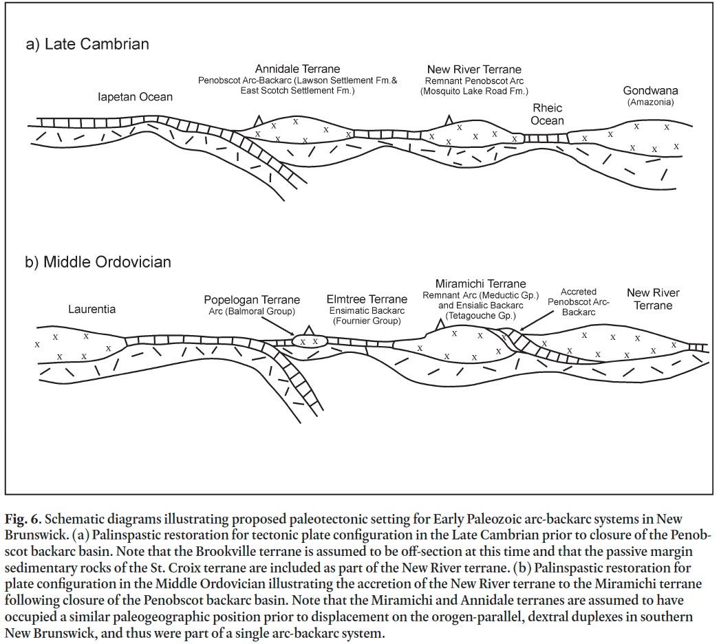 Display large image of Figure 6
87 No volcanic rocks are preserved beneath the Penobscot un-conformity in the type area in Maine. However, wacke beds near the top of the Patrick Brook Formation (Miramichi Group), which lie directly below the unconformity exposed on the Tetagouche River in northeastern New Brunswick, contain abundant volcanic detritus (van Staal and Fyffe 1991, 1995; Fyffe et al. 1997; Rogers et al. 2003). The source rocks for the volcanic detritus are probably from the Penobscot arc, although no remnants of this arc are known in the northeastern Miramichi Highlands. The Miramichi terrane in this region was likely situated in the forearc area of the Penobscot arc during the Early Ordovician. Hence, it would have contained few magmatic rocks and its backarc area may have experienced more or less continuous sedimentation during Penobscot orogenesis. Some igneous rocks exposed in the highly metamorphosed core of the central Miramichi Highlands may have been the products of Penobscot magmatic activity (Fyffe et al. 1988b).
88 The Middle River Rhyolite, a felsite contained in the upper part of the Patrick Brook Formation (Fig. 5), yielded an Early Ordovician (Tremadocian-Floian) U-Pb zircon date of 479 ± 6 Ma (Lentz 1997; McNicoll et al. 2002). If the interpretation that the felsite is a flow is correct, the Penobscot unconformity on the Tetagouche River is younger than late Tremadocian. Felsic tuff of the Nepisiguit Falls Formation just above the un-conformity has a zircon date of 471 ± 3 Ma (Sullivan and van Staal 1996), indicating that Penobscot orogenesis in this area is older than the Dapingian of the Middle Ordovician. Taken together, these dates (479 Ma and 471 Ma) suggest that the Penobscot unconformity in northeastern New Brunswick is confined to the early Floian at the top of the Early Ordovician. Thus the unconformity is possibly younger there than in the Annidale terrane in southern New Brunswick, which is known with certainty to be older than 479 ± 2 Ma (see above). However, the similarity in the age of the felsite to the post-Penobscot London Settlement Rhyolite in the Annidale terrane raises the possibility that the Middle River Rhyolite is actually a sill that postdates the unconformity. This would limit Penobscot deformation to being no younger than late Tremadocian in northern New Brunswick.
89 The presence of Mesoproterozoic granodiorite boulders in the post-Penobscot Ordovician Vallée Lourdes Member of the Nepisiguit Falls Formation at the base of the Tetagouche Group (Fig. 5) indicates that the elements of the Penobscot arc sourced here were built on continental basement (van Staal et al. 1996). At least part of the Annidale terrane is likely under-lain by Neoproterozoic basement as indicated by the presence of detrital zircons dated at 632 ± 5 Ma, 616 ± 5 Ma, and 552 ± 2 Ma in tuffaceous rocks near the base of the Carpenter Brook Formation in the Annidale Group (Johnson et al. 2009).
90 The Miramichi and Annidale terranes share a similar history of Penobscot uplift, although the former is presently located considerably farther outboard with respect to the Gondwanan margin than the latter, a separation analogous to that of the Victoria Lake Supergroup and Bay du Nord Group in Newfoundland. This separation could be explained by geodynamic processes related to asymmetric spreading in backarc basins, which can lead to the sequential generation of multiple arcs in relatively short periods of time (Busby 1998; Zagorevski et al. 2010). The question then arises as to whether the Penobscot volcanic rocks of the Miramichi and Annidale terranes were both part of the same arc or represent two distinct arcs. Restoration of Late Silurian to Early Devonian dextral displacement along orogen-parallel, transcurrent faults, which are concentrated along the trailing edge of the Ganderian microcontinent in southern New Brunswick (Figs. 2, 3), strongly suggests that the Miramichi and Annidale terranes were once part of a single arc-backarc system (Figs. 6a, b). Differences in their sedimentary, volcanic, and tectonic histories are, therefore, more likely to have been controlled by variations in paleotectonic settings along the trend of the same Penobscot arc.
Taconic orogenic cycle
91 The Popelogan terrane in the Matapédia Basin of northwestern New Brunswick is interpreted as an extensional, north-westerly migrating arc that developed above a southeasterly dipping subduction zone following closure of the Penobscot backarc basin (Fig. 6b). Rollback of the down-going plate led to the opening of the Tetagouche backarc basin, leaving the older remnant Meductic arc behind in the southwestern part of the Miramichi terrane (van Staal and Fyffe 1991, 1995; van Staal et al. 1991). In northern New Brunswick, Upper Ordovician (Hirnantian) calcareous grit at the base of the White Head Formation disconformably overlies Upper Ordovician (Sandbian) volcanic rocks and black shales of the Popelogan terrane (Wilson 2000). This hiatus is interpreted to indicate uplift of the Popelogan arc resulting from its accretion to the Laurentian margin. As such, this late Taconic tectonic event records the complete closure of the main tract of the Iapetus Ocean during the Late Ordovician (van Staal 1994; Wilson 2000; Wilson et al. 2004; van Staal et al. 2009). Closure of the Iapetus Ocean by this time is supported by the presence of conodonts with a Midcontinent provinciality in the Goss Point limestone of the Mascarene Basin in southern New Brunswick (Nowlan et al. 1997).
Salinic orogenic cycle
92 A Late Silurian unconformity recognized throughout much of the northeastern Appalachians has been referred to as the Salinic disturbance by Boucot et al. (1964), Boucot (1968), and Roy (1980); and as the Salinic orogeny by Dunning et al. (1990). De Roo and van Staal (1994), van Staal and de Roo (1995), West et al. (2003), and van Staal et al. (2008, 2009) extended this definition to include diachronous tectonic events that occurred within Ganderia between the Late Ordovician and Late Silurian. The various stages of Salinic uplift (Figs. 4, 5) can be related to sequential accretion of the Elmtree and Miramichi terranes to composite Laurentia by closing of the Tetagouche backarc basin (van Staal et al. 2008, 2009).
93 Middle to Upper Ordovician bimodal volcanic rocks of the Tetagouche Group are considered to have been deposited in an ensialic intra-arc rift that opened behind the Popelogan arc above a southeasterly directed subduction zone that was initiated following closure of the Penobscot backarc basin (Fig. 6b). This intra-arc rift eventually evolved into a wide backarc basin floored, in part, by ophiolitic rocks of the Fournier Group (van Staal 1987, 1994; Paktunc 1990; van Staal and Fyffe 1991, 1995; van Staal et al. 1991, 2003; Winchester et al. 1992a, b). The Taconic accretion of the Popelogan arc in the Late Ordovician caused the subduction zone to step outboard and switch subduction direction to the northwest beneath the composite Laurentian margin. The interpreted change in subduction polarity is supported by the presence of a volcanic arc signature in Lower Silurian mafic volcanic rocks interbedded with conglomerate at the base of the Chaleurs Group along the Bay of Chaleur (Wilson et al. 2008). Later within-plate volcanism in the Late Silurian and Early Devonian in the Matapédia Basin has been attributed either to rifting related to transcurrent fault movement (Dostal et al. 1989), or to break-off of the subducting slab (de Roo and van Staal 1994; van Staal and de Roo 1995).
94 Two main stages of Tetagouche backarc basin closure are recorded by Salinic unconformities within the Silurian Chaleurs Group along the southeastern margin of the Matapédia Basin. Obduction and closure of the ensimatic part of the basin, remnants of which are preserved in the Elmtree terrane, took place during the Early Silurian. In the later stages of subduction, the leading edge of the more buoyant, ensialic part of the basin entered the subduction zone and was exhumed by the Middle Silurian (Brunswick subduction complex of de Roo and van Staal (1994) and van Staal and de Roo (1995)). Deformation related to this exhumation was accompanied by blueschist metamorphism and stacking of a series of major nappe structures to form the Brunswick subduction complex (van Staal et al. 1990; van Staal 1994; de Roo and van Staal (1994); van Staal and de Roo 1995; van Staal et al. 2008). This metamorphism has been dated by 40Ar/39Ar on crossite and phengite to have occurred in the Early Silurian, between 447 ± 6 Ma and 430 ± 4 Ma (van Staal et al. 2008).
95 The deep-water carbonates of the Matapédia Basin do not extend eastward beyond the Jacquet River Fault (Fig. 2); instead, shallow-water Lower Silurian (Llandoverian) conglomerate of the Weir Formation at the base of the Chaleurs Group unconformably overlies Middle Ordovician gabbroic rocks of the Elmtree terrane. This unconformity defines an Early Salinic uplift related to closure of the ensimatic part of the Tetagouche backarc basin (Noble and Howells 1974, 1979; Noble 1976; Irrinki 1990; Dimitrov et al. 2004; van Staal et al. 2009). The later Salinic event related to uplift of the ensialic part of the backarc basin is defined by the Upper Silurian (Ludlovian) Simpsons Field conglomerate, which lies unconformably along the northern margin of the Miramichi terrane. These events are clearly younger than the Taconic accretion of the Popelogan volcanic arc to the Laurentian margin in the Late Ordovician (Fig. 5).
96 The later Salinic unconformity is also recorded in the deeper part of the Silurian basin lying north of the Miramichi terrane (Fig. 5). The Simpsons Field conglomerate along the southern margin of the basin is overlain conformably by Upper Silurian (Pridolian) reefal limestone of the LaPlante Formation (Noble 1985; Dimitrov et al. 2004). This reefal facies is referred to as the West Point Formation in the Campbellton area (Figs. 2, 5), where it disconformably overlies the lower part of the Chaleurs Group (Wilson 2002; Wilson et al. 2004; Wilson and Kamo 2008). Folds lacking an axial plane cleavage and overprinted by a regional Acadian cleavage are common in strata of the Matapédia Group and lower parts of the Chaleurs Group below this late Salinic unconformity (Stringer 1975; Rast et al. 1980; de Roo and van Staal 1994; van Staal and de Roo 1995; Dimitrov et al. 2004).
Acadian orogenic cycle
97 The Taconic, Penobscot, and Salinic tectonic events are related to volcanic arc accretion and hence are relatively local in nature. In contrast, Acadian deformation is widespread throughout the northeastern Appalachian orogen and so has generally been attributed to a major collision between the Avalonian microcontinent and the Laurentian margin (Bird and Dewey 1970; Bradley 1983; Malo 2001; Tucker et al. 2001). However, earliest Acadian deformation and metamorphism in New Brunswick also appears to be relatively local and is postulated to be related to the closure of the Acadian Seaway, a marginal basin positioned between Avalonia (Caledonia terrane) and Ganderia. Closure of this putative oceanic basin by oblique convergence led to the collision of the Avalonian microcontinent with the trailing edge of Ganderia (Brookville and New River terranes) (van Staal et al. 2009; van Staal and Hatcher 2010; van Staal and Barr in press).
98 Bradley (1983) had previously concluded that Silurian volcanic rocks in coastal Maine were generated above a southeasterly directed subduction zone and that convergence along this zone was responsible for closing of the Fredericton Trough between the St. Croix and Miramichi terranes. We will use Bradley’s term ‘Coastal arc’ in this paper to refer to volcanic rocks of the Kingston Basin but maintain that subduction was directed to the northwest beneath the trailing edge of Ganderia. In southern New Brunswick, a zone of high-pressure, low temperature metamorphism is associated with mylonitization along the Kennebecasis-Pocologan Fault. This fault marks the boundary between the Early Silurian arc sequence of the Kingston Basin and Neoproterozic basement rocks of the Brookville terrane to the southeast (Fig. 3). The metamorphism postdates intrusion of a Silurian granite pluton, which yielded a U-Pb zircon date of 435 ± 5 Ma, but predates metamorphic cooling ages on mafic dykes dated by 40Ar/39Ar at 416 Ma to 390 Ma (Nance and Dallmeyer 1993; McLeod et al. 2001; Barr et al. 2002; White et al. 2006). This high-pressure metamorphism is attributed to northwesterly directed subduction beneath the Coastal arc, which is consistent with the interpretation that Upper Ordovician to Silurian volcanic and sedimentary rocks of the Mascarene Group (Figs. 3, 4) represent backarc basin fill (Fyffe et al. 1999; Barr et al. 2002; van Staal et al. 2009; van Staal and Barr in press).
99 The Upper Silurian Eastport Formation at the top of the Mascarene Group is a distinctly bimodal volcanic assemblage that exhibits within-plate, subalkalic geochemical signatures (Van Wagoner et al. 2001, 2002), suggesting its generation in a continental extensional setting on the passive side of the Mascarene backarc basin. The increase in intensity of deformation from northwest to southeast across the Mascarene Basin is attributed to the focusing of dextral transpression along its active arc side. Avalonia effectively became part of Laurentia with the destruction of this last vestige of oceanic crust in the latest Silurian to earliest Devonian. However, considerable transcur-rent displacement continued to be focused along this suture well into the Carboniferous (Leger and Williams 1988; Doig et al. 1990; Eby and Currie 1993; Nance and Dallmeyer 1993; Park et al. 1994, 2008; Stewart et al. 1995; Schreckengost and Nance 1996; Currie and McNicoll 1999).
100 The wide-spread effects of Acadian deformation, which followed closure of the Acadian Seaway, have been attributed to protracted, flat-slab subduction of the Avalonian microcontinent beneath the composite Laurentian margin (Murphy et al. 1999; Murphy and Keppie 2005; van Staal et al. 2009). An unconformity between the volcanic rocks of the late Lochkovian to early Emsian Dalhousie Group and the overlying late Emsian Campbellton Formation indicates that this front had migrated northwestward to the Bay of Chaleur area by the late Early Devonian (Dineley and Williams 1968; Donohoe and Pajari 1974; Wilson et al. 2004, 2005; Burrow et al. 2008). Farther north on the Gaspé Peninsula in Québec, Acadian deformation is as least as young as Middle Devonian (early Eifelian) (Malo and Bourque 1993; Malo 2001).
TECTONO-SEDIMENTARY BASIN EVOLUTION
101 The sedimentary rocks of the St. Croix terrane in southwestern New Brunswick record the evolution of the New River terrane from a passive to active margin between the Cambrian and Early Ordovician. The quartzose sandstone sequence of the Crocker Hill Formation at the base of the Cookson Group was likely deposited on the Gondwanan continental margin prior to the opening of the Penobscot backarc basin and so is no younger than early Middle Cambrian. Support for this interpretation comes from the recognition that Gander-like, quartz-rich sandstones of the Almond Road Group lie with probable disconformity on the Neoproterozoic to earliest Cambrian rocks of the New River terrane (Fig. 4). Felsic tuff interbedded with black shale of the Penobscot Formation in coastal Maine (equivalent to the Calais Formation, which overlies the Crocker Hill Formation on the New Brunswick-Maine border) yielded a U-Pb zircon date of 503 ± 5 Ma (Tucker et al. 2001). The onset of a marine transgression indicated by the deposition of black shale thus must have begun as early as late Middle Cambrian, which is consistent with the opening of the Penobscot backarc basin at this time. The age of this tuff bed is virtually identical to that of the Castine Volcanics (504 ± 3 Ma) in the Ellsworth terrane in coastal Maine, suggesting a close relationship between these two units in the Middle Cambrian and lending support to our interpretation that New River basement forms the foundation to the St. Croix terrane.
102 The New River-St. Croix association is also supported by the similar tholeiitic compositions of the basalts at the base of the Calais Formation and in the Castine Volcanics (Fyffe et al. 1988a; Schultz et al. 2008). These MORB-like basalts are likely related to the initiation of Penobscot backarc rifting, but it is not known whether extension was sufficient to separate the St. Croix terrane completely from the trailing edge of Ganderia (New River and Brookville terranes). The upsection change from deposition of black shale of the Calais Formation to the coarser feldspathic wacke sequence of the Woodlands Formation (Fig. 4) may be related to the stacking of thrusts during closure of the Penobscot backarc basin. The abundant quartz in the overlying Upper Ordovician Kendall Mountain Formation is likely sourced from the trailing edge of Ganderia as a result of uplift of the New River terrane during basin closure. The quartz-rich sedimentary rocks of the Kendall Mountain Formation in effect represent deposition on the passive margin side of the spreading Tetagouche backarc basin. Notably, quartzose rocks of Late Ordovician age are not present in the Tetagouche Group on the active arc side of the basin in northern New Brunswick.
103 Early Silurian conglomerate of the Oak Bay Formation at the base of the Mascarene Group lies on highly deformed shale of the Calais Formation on the south flank of the St. Croix terrane (Fig. 4). The pre-Oak Bay folding in the Calais Formation may be related to Penobscot orogenesis, the early stages of Salinic orogenesis, or a combination of both (van Staal et al. 2009). The Lower Silurian (early Llandoverian) wacke beds in the Digdeguash Formation of the Kingsclear Group, which disconformably overlies the Kendall Mountain Formation on the north flank of the St. Croix terrane, contain detrital micas with an 40Ar/ 39Ar date of ~ 484 Ma (L. Fyffe, unpublished data). This provides strong evidence that the Cambrian to Early Ordovician volcanic rocks of southern New Brunswick had been metamorphosed and uplifted as a result of Penobscot orogenesis well before the Early Silurian. No Early Ordovician hiatus associated with this Penobscot deformation has been positively identified within the sedimentary rocks of the underlying Cook-son Group. However, felsic tuff layers interbedded with conglomerate at the base of the Kendall Mountain Formation likely correlate with post-Penobscot volcanism in the Annidale and Miramichi terranes (Fig. 5), which in turn is related to development of the younger Popelogan arc-Tetagouche backarc system (Fyffe and Riva 1990; van Staal et al. 2003). If this correlation is correct, it appears likely that a significant pre-Kendall Mountain stratigraphic break occurs within the Cookson Group (Fig. 4).
104 We postulate that the initiation of Silurian subsidence recorded by the disconformity between the Kendall Mountain Formation of the St. Croix terrane and Digdeguash Formation of the Fredericton Trough resulted from the southerly directed movement of a foreland bulge produced by the emplacement of the stacked nappes of the Brunswick subduction complex (van Staal et al. 1990, 2008; van Staal 1994; de Roo and van Staal 1994; van Staal and de Roo 1995; Park and Whitehead 2003). The Fredericton Trough thus represents a foredeep basin formed by Salinic tectonic loading along Ganderia’s active margin. This interpretation is supported by the apparent shallowing within the Fredericton Trough as indicated by the facies change from thickly bedded, siliciclastic turbidites of the Burtts Corner Formation in the north to the more thinly bedded, calcareous sandstone sequence of the Flume Ridge Formation in the south (Fig. 4). The 40Ar/ 39Ar dating of micas from the Flume Ridge Formation, which conformably over-lies the Digdeguash Formation, yielded an Early Silurian (late Llandoverian) age of 435 Ma (unpublished data), consistent with derivation of these micas from erosion of the rising nappes. Fossil evidence and the 423 ± 3 Ma age of a cross-cutting mafic intrusion (West et al. 1992; Fyffe 1995) suggest that inversion of the Fredericton Trough had occurred by the Late Silurian (late Ludlovian). This event signifies the final closure of the Tetagouche backarc basin along the leading edge of Ganderia, and thus marked the terminal stage of Salinic accretion, which effectively united the entire peri-Gondwanan microcontinent of Ganderia with Laurentia.
105 Shallowing-upward (regressive) intervals in tectonically active sedimentary basins record the infilling of the basin through increased influx of sediment derived from uplifted source areas. Typically, the regressive interval begins with siliciclastic sediments deposited in a slope or deep-shelf enviroment and passes upward into carbonates deposited in a shallow-shelf setting. An early regression interval, associated with tectonic uplift in the Penobscot backarc basin of the Annidale terrane, is recorded by the presence of conglomerates at the base of the London Settlement domal complex in southern New Brunswick and at the base of the Tetagouche Group in northeastern New Brunswick (Fig. 5). This Penobscot event led to accretion of the Miramichi and Annidale terranes to the New River terrane by the Early Ordovician.
106 Flooding of calcareous detritus into the Matapédia Basin in the Late Ordovician to Early Silurian was the result of earlier tectonic loading of the Laurentian carbonate shelf following collision with the fringing Notre Dame arc in the Middle Ordovician stage of the Taconic orogeny (Rodgers 1971; St. Julien and Hubert 1975; Malo 1988; van Staal et al. 2009). Four regressive intervals can be recognized in the Upper Ordovician to Lower Devonian depositional sequences of the Matapédia Basin (Fig. 5), each reflecting sequential accretion of a particular terrane to the Laurentian margin (Wilson et al. 2004). These include the following: (1) late Taconic regression (Late Ordovician) – Whites Brook Formation and Pabos Formation in the deeper part of the basin (accretion of Popelogan terrane by subduction of the main tract of the Iapetus Ocean); (2) early Salinic regression (Early to Middle Silurian) – Weir Formation and La Vieille Formation proximal to the basin margin; and Upsalquitch Formation and Limestone Point Formation distal to the basin margin (accretion of the Elmtree terrane by subduction of the ensimatic part of the Tetagouche backarc basin); (3) late Salinic regression (Late Silurian) – Simpsons Field Formation and LaPlante Formation proximal to the basin margin; West Point Formation distal to the basin margin; and the upper Smyrna Mills Formation in the deeper southwest part of the basin (accretion of the Miramichi terrane by subduction of the ensialic part of the Tetagouche backarc basin); and (4) Acadian regression (late Early Devonian) – upper Wapske Formation proximal to the basin margin; Val d’Amour Formation and Campbellton Formation distal to the basin margin (following accretion of the Avalonian Caledonia terrane by oblique subduction in the Acadian Seaway).
DISCUSSION AND CONCLUSIONS
107 The cycle of opening and closure of the Iapetus Ocean in the northeastern Appalachians lasted for at least 150 million years. According to Cawood et al. (2001), opening of the Iapetus Ocean along the passive Laurentian margin began at about 570 Ma with the rift to drift transition taking place in the Early Cambrian between 540 Ma and 535 Ma. At this time, the Gondwanan continental margin was an active plate boundary, as indicated by the calc-alkaline composition of plutons (548 Ma to 528 Ma) in the Brookville terrane, and by the volcanic arc signature of the Simpsons Island Formation (539 Ma) in the New River terrane. Nance et al. (2002) and Rogers et al. (2006) have postulated that arc magmatism ceased at this time due to oceanic ridge-trench collision during closure of a Neo-proterozoic ocean along the northern margin of Gondwana. Transcurrent motion within this trapped basin subsequently rotated the northern Gondwanan margin westward to face the spreading Iapetus Ocean. Passive-margin sedimentary rocks deposited along this margin range in age from possibly as old as 539 Ma in the New River terrane to no older than 525 Ma in the Miramichi terrane, based on detrital zircon data (Fyffe et al. 2009).
108 Renewed subduction of Iapetus oceanic crust beneath the Iapetus-facing Gondwanan margin began some 25 million years later in the late Early Cambrian, as indicated by the initiation of Penobscot arc magmatism in the New River terrane. Subsequent rift-related bimodal Penobscot volcanism in coastal Maine demonstrates that the Iapetus-facing Gondwanan margin was under extension in the Middle Cambrian. This rifting was coincident with the opening of the Rheic Ocean, which led to the separation of the Ganderian microcontinent from the Gondwanan craton (Shultz et al. 2008; van Staal et al. 2009). Opening of the Rheic Ocean at this time may have been facilitated by slab-rollback of the Penobscot subduction zone dipping beneath the New River terrane. Continued migration of the subduction zone to the northwest led to the opening of the Late Cambrian to Early Ordovician Penobscot backarc basin between 493 Ma and 482 Ma. As a result of this latest extension, the Annidale terrane and the laterally equivalent Miramichi terrane split away from the New River terrane (Fig. 6a).
109 The Miramichi and Annidale terranes were subsequently reunited with the New River terrane when the Penobscot backarc basin closed during the Early Ordovician Penobscot orogeny (Fig. 6b). Conclusive evidence that the Penobscot basin was closed by the Early Ordovician (Floian) is provided by the age of emplacement of the stitching Stewarton Gabbro at 479 Ma (Johnson et al. 2009). The change of the Penobscot arc system from extensional to compressional tectonic setting, leading to backarc closure, may have been related to an increase in overiding plate velocity caused by the rapid seafloor spreading of the Rheic Ocean during its rift-to-drift transition between 500 Ma and 485 Ma (Murphy et al. 2006; Schultz et al. 2008).
110 Post-Penobscot volcanism in the Annidale terrane lasted from the late Early to late Middle Ordovician (Floian to Darriwilian) – from 478 Ma, the age of the London Settlement Rhyolite, to 467 Ma, the age of the Bull Moose Hill Porphyry (Johnson et al. 2009). A relatively short time after the Penob-scot accretion of the Miramichi terrane to the trailing edge of Ganderia, renewed subduction beneath the leading edge of Ganderia initiated volcanic activity in the Meductic arc at about 473 Ma (Fig. 6b). Further slab rollback of the down-going Iapetus plate to the northwest led to the opening of the Tetagouche backarc basin by 470 Ma. Backarc oceanic crust represented by the Fournier ophiolite of the Elmtree terrane was generated by about 464 Ma. Due to this backarc spreading, the active arc of the Popelogan terrane migrated to the northwest into the Iapetus Ocean, leaving behind the remnant Meductic arc. This post-Penobscot period of magmatism in the Annidale and Miramichi terranes is essentially contemporaneous with that in the Exploits backarc basin of central Newfoundland (MacLachlan and Dunning 1998; van Staal et al. 2003, 2009; Valverde-Vaqeuro et al. 2006a; Zagorevski et al. 2007).
111 The Popelogan terrane was accreted to the Laurentian margin in the Late Ordovician (Katian). This late Taconic event effectively closed the main tract of the Iapetus Ocean between Laurentia and Gondwana. As a result of this closure, the trench jumped outboard of the Iapetus margin, and the direction of subduction flipped to the northwest beneath Laurentia. The subsequent subduction of the oceanic crust of the Elmtree terrane led to closure of the ensimatic part of the Tetagouche back-arc by the Early Silurian (late Llandoverian). This early Salinic event is marked by the unconformity between late Llandoverian conglomerate of the Chaleurs Group and underlying ophiolitic rocks of the Fournier Group. Shallow slab subduction during this stage generated arc-related, mafic volcanic rocks interbedded with Lower Silurian conglomerate near the base of the Chaleurs Group. In the later stages of subduction, the leading edge of the more buoyant, ensialic part of the Tetagouche backarc basin of the Miramichi terrane entered the northwesterly directed subduction zone and was exhumed by the Middle Silurian. Following the exhumation, Upper Silurian (Ludlovian) conglomerate was deposited along the northern margin of the Miramichi terrane.
112 The closure of the Tetagouche backarc basin during the Salinic orogeny united the peri-Gondwanan terranes of Ganderia with composite Laurentia by the early Late Silurian. Later within-plate volcanism in the Matapédia Basin during the later Silurian and Early Devonian is attributed either to transcurrent fault movement or to the break-off of the Salinic subducting slab. The Acadian orogeny began with the latest Silurian to earliest Devonian collision of Avalonia with Laurentia during contraction and closure of the Acadian Seaway. Subduction of Avalonia beneath Laurentia led to the progressive migration of the deformation front from the southeast to the northwest resulting in inversion of the Matapédia Basin by the late Early to early Middle Devonian and termination of the Acadian orogeny in the northeastern Appalachians.
Malcolm McLeod and Sandra Barr provided valuable discussions about field relationships, and together with Reg Wilson offered comments on an early draft of the paper. Terry Leonard and Erin Smith prepared the figures. Insightful suggestions by journal reviewers Jim Hibbard and Doug Reusch for improving the manuscript are greatly appreciated.