Articles
Geological and site specific factors influencing earthquake hazard assessment for New Brunswick, Canada
ABSTRACT
Seismic hazard studies by Earthquakes Canada place most of New Brunswick in the moderate part of the hazard range. Limitations are identified with the documented earthquake database suggesting that revisions are necessary for location and magnitude of some of the known historical earthquakes. In addition, the disturbance from a given event magnitude can be modified by local geological conditions and site specific factors. This is particularly true for New Brunswick, where many of the communities were settled along river valleys and coastal areas, which are under-lain by thick deposits of glacial and alluvial sediments that can amplify ground motion. The historical documentation and paleoseismic studies that identify seismic-generated disturbances are reviewed in this paper. Ground motion from both moderate (4 MN) local and large (> 5 MN) regional earthquakes represents a hazard at some locations and particularly those sites adjacent to steep slopes or sites underlain by thick surficial deposits. Amplification of ground motion would be expected at sites overlying low shear wave velocity zones typical of alluvial sediments. This may explain the larger shaking effects experienced in the downtown area of Fredericton from distant earthquakes. Alteration of springs, rivers and groundwater supplies has happened as a result of earthquakes, although few effects remain permanent. Reports of earthquake-generated tsunamis and lake seiches are rare for New Brunswick. Earthquake-induced rock falls occurred along some rock slopes during moderate earthquakes in 1855 and 1937, and a landslide occurred in marine sediments possibly triggered by a minor unrecorded local tremor in 1977. This study identifies the need for future paleoseismic research and microzonation studies for the major communities within the province.
RÉSUMÉ
Des études de l’aléa sismique réalisées par Séismes Canada situent la majeure partie du Nouveau‑Brunswick au niveau moyen de l’échelle de l’aléa. La base de données sismologiques documentées fait part de restrictions laissant supposer la nécessité de révisions de l’emplacement et de la magnitude de certains des tremblements de terre passés connus. De plus, les secousses dues à la magnitude d’un séisme donné peuvent être modifiées par les conditions géologiques locales et par des facteurs propres à l’emplacement. C’est particulièrement le cas au Nouveau‑Brunswick où de nombreuses localités se sont implantées le long de vallées fluviales et de secteurs côtiers qui reposent sur des dépôts épais de sédiments glaciaires et alluvionnaires pouvant amplifier les mouvements du sol. Cet article passe en revue la documentation historique et les études paléosismiques qui définissent les secousses sismiques. Les mouvements du sol que produisent les tremblements de terre régionaux importants (> 5 MN) et locaux moyens (4 MN) représentent un aléa en certains endroits, particulièrement à proximité des pentes abruptes ou des secteurs reposant sur des dépôts superficiels épais. Une amplification des mouvements du sol peut être anticipée dans les secteurs recouvrant des zones de faible vitesse d’ondes transversales typiques des sédiments alluvionnaires. Une telle situation pourrait expliquer les secousses plus marquées vécues dans le centre‑ville de Fredericton par suite de tremblements de terre éloignés. Certains séismes ont modifié des ruisseaux, des rivières et des réserves d’eaux souterraines, mais de tels effets sont rarement permanents. Il est rare qu’on signale des tsunamis et des seiches sur des lacs dus à des tremblements de terre au Nouveau‑Brunswick. Des éboulements provoqués par des séismes sont survenus le long de certaines pentes rocheuses au cours de tremblements de terre moyens en 1855 et en 1937, et un glissement de terrain possiblement déclenché par une faible secousse sismique locale non enregistrée en 1977 s’est produit dans des sédiments marins. L’étude démontre la nécessité d’études de microzonation et de recherches paléosismiques futures visant les principales localités de la province.
[Traduit par la redaction]
INTRODUCTION
1 The procedures for the determination of earthquake hazard are well established and consist of two major methods: (1) probabilistic, based on the earthquake record and (2) deterministic, where seismicity can be related to specific faults (Reiter 1990). A prime requirement is the compilation of earthquakes recorded by seismograph networks, extended, if possible, by a catologue of historical earthquakes. Probabilities of re-occurrence of earthquake magnitudes can then be calculated based on this information. Paleoseismic studies will oſten add essential information and extend the time interval over which the hazard is assessed by utilizing information from a variety of disciplines that could include Quaternary geology, geomorphology, archaeology and structural geology (e.g., Broster et al. 1993; Tuttle et al. 1996). If seismogenic faults do not occur in the region, then source zones, within which earthquake characteristics are similar, need to be identified.
2 Earthquakes Canada is responsible for the evaluation of regional seismic hazard in different parts of Canada. Seismic hazard maps have been prepared by analyses of the past earthquake records and from information on a region’s tectonic and geological structure. These maps show the largest ground motion that is expected to occur in an area for a given probability level. The relative seismic hazard across Canada for one- to two-story structures places most of New Brunswick in the moderate part of the hazard range (Natural Resources of Canada 2010a).
3 Moderate hazard regions represent a 5 to 15% chance that significant damage could occur every 50 years. Site specific values can be determined using a menu on the Earthquakes Canada web site (Natural Resources of Canada 2010b).
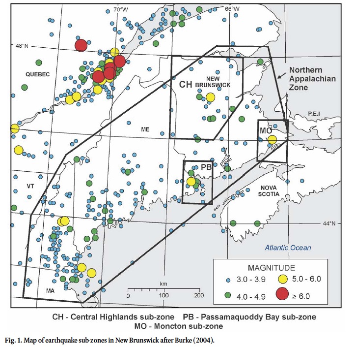
4 Earthquakes Canada has identified earthquake zones likely to experience similar levels of activity in Canada. Most of New Brunswick lies within the Northern Appalachian (earthquake) Zone (Natural Resources of Canada 2010c), which extends from Nova Scotia south into the New England states. Burke (2004) has identified three areas of enhanced activity in New Brunswick; the Central Highlands, Moncton, and Passamaquoddy Bay subzones (Fig. 1). Halchuk et al. (2004) calculated maximum likelihood estimates of probability for these subzones using the method of Weichert (1980). This study showed that the activity rate in the Central Highlands subzone is higher by a factor of at least 2, and in the Passamaquoddy Bay subzone the activity rate is higher by a factor of 2 to 3, compared to the Northern Appalachian Zone. In contrast, the activity rate in the Moncton subzone, in spite of the magnitude 5.4 earthquake of 1855, was only about a half of that in the Northern Appalachian Zone (Halchuk et al. 2004). It is likely that the sampling period was too short for reliable estimates to be made for this latter subzone.
 Display large image of Figure 1
5 Although it may appear that the seismic hazard for New Brunswick is well defined by the above probabilistic studies, there are geological and site specific factors that may influence the hazards from earthquakes. For example, the deformation resulting from earthquake can usually be related to the magnitude and distance to the epicentre of an earthquake. Fault length and vertical displacement of bedrock are oſten measured and attributed to the size of the seismic event (i.e., Reiter 1990). However, where bedrock is buried, the intensity of the event may also be reflected as deformation structures in overlaying deposits of fine-grained sediments. Bolt (1995, p. 165) reports that during the 1977 Ms 7.2 earthquake in Romania, sand boils occurred along the Danube River at a distance of 400km from the epicentre. Deformation structures in delta sediments examined at Economy Point, Nova Scotia (Broster and MacDougall, 1997) on the north shore of the Minas Basin were attributed to the 1855 (M 5+) earthquake at Moncton, New Brunswick, 100km to the west. Unstable slopes in landslide prone areas can be triggered to fail and endanger people and property. In addition, many communities are built on thick deposits of alluvial or glacial deposits, which enhance the effects of low frequency seismic waves. In some areas, the configuration of deep river valleys focus and increase the amplitudes of arriving waves, particularly when underlain by fine-grained sediments. It is to be expected that earthquake shaking will therefore be modified by local geological conditions across the province. Such phenomena are recorded in the descriptions of historical New Brunswick earthquakes (e.g., Burke 2009) and identified for the pre-historical period from two paleoseismic studies. This paper will describe some of the reported effects of historical and paleoseismic events documented at sites across New Brunswick and show why caution must always be used in assessing the hazards from earthquakes.
EARTHQUAKE HAZARD ASSESSMENT
Instrumental observation of New Brunswick earthquakes
6 The magnitude 5.4 earthquake on July 2, 1922 is the first New Brunswick earthquake recorded by seismographs, although the stations were outside the province (Humphreys 1922a, 1922b). No instrumentally determined magnitude was reported for this latter event. The first recorded earthquakes in the province for which instrumentally calculated magnitudes were reported occurred on January 4, 1930 and September 30, 1937, for which a MLs of 4.6 and 5.0 are listed respectively by Smith (1966). Because Smith did not have a correct epicentre for this event, the magnitude for the 1937 earthquake was recalculated to be an MN = 4.4 by Burke (2009).
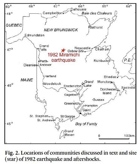
7 However, it was not until the 1960s that a network of seismographs was available in eastern Canada to allow the recording of earthquakes with magnitudes as low as 2 to 3 in the province. For the period 1970 to 1982, a single vertical component station (UNB) was operated for the Geophysical Division of the Earth Physics Branch at the University of New Brunswick in Fredericton. Aſter the magnitude 5.7 Miramichi earthquake on January 9, 1982, seismometers were installed in the province at Edmundston (EBN), Caledonia Mountain (LNM), about 40 km, south of Moncton, McKendrick Lake (KLN), about 20 km southeast of the Miramichi earthquake epicentre and St. George (GGN). These seismometers formed part of the Eastern Canada Telemetered Network (ECTN) from 1982 until the early 1990s. Today, only seismometer installations at Caledonia Mountain and St. George remain within the province (Fig. 2). These latter stations are now broad band, three component stations, whose traces can be accessed on the Internet (Natural Resources of Canada 2010b).
 Display large image of Figure 2
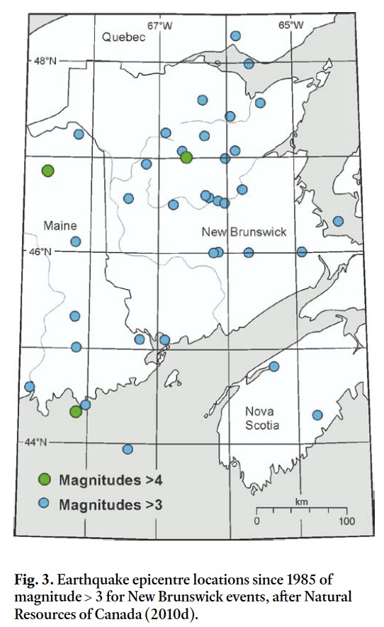
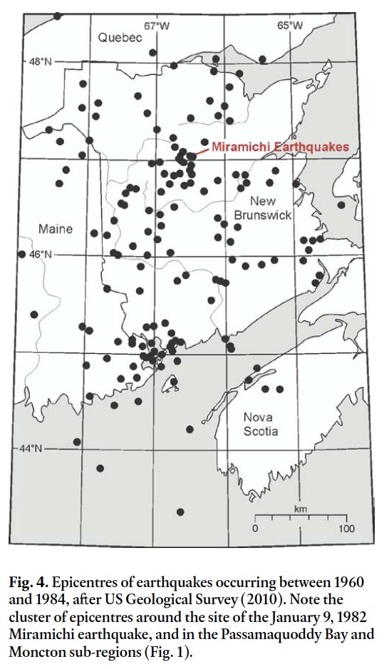
8 A database of Canadian earthquakes from 1985 onwards is available on the Earthquakes Canada website (Natural Resources of Canada 2010d). Lists and maps for selected regions can be obtained from this database by specifying latitudes and longitudes for a search area. A map showing the epicentres for earthquakes with magnitudes of 3 or greater in New Brunswick for the period 1985 to the present is shown in Fig. 3. Data prior to 1985 is not included in this data base, which omits the 1982 sequence of earthquakes in the Miramichi area of the Central Highlands; the largest New Brunswick earthquake events recorded by seismographs. Epicentres for New Brunswick events for this period are plotted in Fig. 4. On both maps, the main events plot in the Central Highlands sub-zone (Burke 2004), where there has been a concentration of historical earthquakes (see below) and in the Passamaquoddy Bay and Moncton sub-zones (Fig. 1).
 Display large image of Figure 3
 Display large image of Figure 4
9 The 1982 Miramichi earthquake has been the only New Brunswick event to be subjected to a comprehensive study of geology and effects in the instrumentally recorded period. Basham and Adams (1984) report that the mainshock M 5.7 occurred January 9 and was followed by M 5.1 aſtershock three and a half hours later and by an M 5.4 aſtershock two and a half days later on January 11; field instruments recorded a further 237 aſter shocks in the 25 hour period between January 13–14th. Minor shocks (aſtershocks?) associated with this system are still occurring to this date. Focal mechanism studies of the main event and larger aſtershocks indicate a north trending conjugate V pattern of thrust faulting (e.g., Wetmiller et al. 1984; Basham and Kind 1986). On-site examinations by Basham and Adams (1984) of diorite outcrops close to the epicentre showed a few minor cracks, small-scale thrusting along a pre-existing joint (possibly glacitectonic), and a pop-up feature attributed to unloading during excavation, but no surface expression of a causative fault was found. In compressional tec-tonic settings, faults tend to develop as splays or blind thrusts and might not reach the surface (Wheeler and Johnston, 1992). Where fractures may have reached the surface the heavy vegetation and cover of glacial deposits would make small displacements extremely difficult to find. In these areas, sand blows and other seismic-generated disturbance of surface sediments may be the only evidence of a recent event. However, the Miramichi event occurred during conditions of frozen ground and was followed by 0.5 m of fresh snow before investigators could get to the site (Basham and Adams 1984, p. 117).
10 Fortunately, this 5.7 magnitude earthquake and large aſter-shocks were centred in a remote part of the Central Highlands. A full building damage survey was made aſter the event (Pernica and Maurenbrechen, 1982). Minor damage was reported in a few communities, at distances ranging between 60 to 115 kms from the epicentre. Cracks in foundation walls, concrete block walls and plaster-lathe wood partitions were noted, although in many cases these tended to be caused by the widening of pre-existing cracks. Damage to stairwell walls was observed in a senior citizens’ home in Bathurst (100 km from epicentre) and a hospital in Perth-Andover (85 km from epicentre). Gyproc panels were cracked in several retail stores, particularly in a one-storey store in Chatham (85 km from epicentre), where floor to ceiling cracks were developed or widened (see Fig. 2 for locations).
Historical earthquakes (1811–1960)
11 The historical seismicity of New Brunswick was investigated initially as part of a much larger study for the whole of eastern Canada by Smith (1962, 1966). Historical earthquakes of the region were included in a study of relationship to geological structure by Rast et al. (1979) and in a review of seismicity of the Maritime Provinces by Burke (1984). Leblanc and Burke (1985) studied the four largest known historical earthquakes in the Maine-New Brunswick region.
12 Earthquakes Canada maintains a comprehensive computer list of earthquakes as the National Earthquake Data Base (NEDB), formerly called the Canadian Earthquake Epicentre File (CEEF). Burke (2009) recently completed a study of historical earthquakes of New Brunswick for the years 1811–1960 and found evidence of 38 earthquakes, previously unlisted in NEDB. Most of the previously unlisted earthquakes were of relatively small magnitude and were only reported in one or two local newspapers, which may explain their absence from the NEDB. However, four moderate events in the Central Highlands were also identified by Burke (2009) that may have been missed previously because of their remote location far from larger communities. These moderate events were of magnitudes: 3.9 on March 16, 1863; 4.0 on December 18, 1903; 4.4 on March 20, 1911; and 3.9 on March 30, 1925.
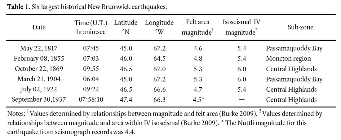
13 The Modified Mercalli (MM) intensity scale is used to assign intensity levels from I to XII for an event (e.g., Reiter 1990; Bolt 1995). Table 1 lists the six largest earthquakes to have occurred during this period. The magnitudes and epicentres of the first five events are based upon the felt area and areas within the MM IV isoseismal. The epicentre and magnitude of the 1937 earthquake were determined by both instrumentally recorded data and felt data.
14 In the accounts of earthquakes in newspapers and other documentary sources, there is a wide range of reported effects for New Brunswick earthquakes, from simply ‘felt’ (MM II or III) to reports of ‘chimneys collapsing and walls cracking’ (MM VI–VII). The most common effects reported are the ‘rattling of dishes or windows’ and ‘people were awaken’ by the event (MM IV).
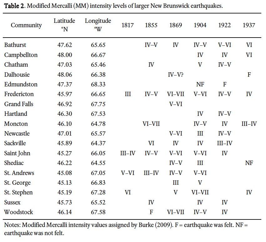
15 In Table 2, a summary of the Modified Mercalli intensity levels for those New Brunswick communities that reported having experienced the effects of these earthquakes is presented. As expected, most of the larger intensity values are listed where communities are close to the epicentre of an event. For example, intensity values of VI–VII have been assigned to St. Stephen for the 1817 and 1904 Passamaquoddy Bay earthquakes, because of chimney damage reported from there. Bricks falling from chimneys and cracking of plaster on walls in Moncton and nearby Hopewell, at the time of the 1855 earthquake, indicate these communities experienced intensities of VI and are in the epicentral region. Great rents in roadways and the river bank along the Petitcdiac River were observed for this latter event. Chimneys were knocked down or displaced in central New Brunswick communities at the time of the 1869 earthquake, which has been assigned a location in the Central Highlands (Burke 2009). Some springs appeared and others disappeared along the SW Miramichi River valley.
 Display large image of Table 2
16 However, closeness to the epicentre is not required for damage to occur, particularly where local site conditions amplify the ground motion. This is the case for those places situated on unconsolidated deposits, as illustrated by the intensity values at Fredericton (discussed below), where early historical settlement had taken place on a river plain of thick alluvial sediments. Effects reported from there caused by quite distant earthquakes, such as those of 1855 and 1904, give intensity values that appear to be higher by one or two units than expected for the response at distances of 150 and 100 km respectively from the epicentres of these events.
Large regional earthquakes
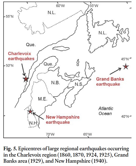
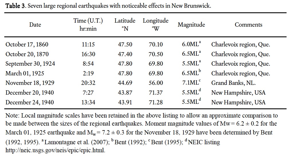
17 Seven large regional earthquakes in the historical period from 1860 to 1960 have had noticeable effects in New Brunswick. Four of these earthquakes occurred in the Charlevoix region of Quebec, two in the state of New Hampshire in the USA and one occurred on the Grand Banks, in the Atlantic Ocean, south of Newfoundland (Fig. 5, Table 3). The distances from the epicentres of the Quebec earthquakes vary from about 160 km to Edmundston, in northwest New Brunswick, to about 500 km to Sackville, a community in the south east part of the province. Distances between the epicentral region of the New Hampshire earthquakes and New Brunswick vary between 360 km on the western boundary to 620 km on the eastern boundary of the province. The distances to the epicentre of the Grand Banks earthquake are 670 km from Sackville to about 1000 km from Edmundston respectively.
 Display large image of Figure 5
 Display large image of Table 3
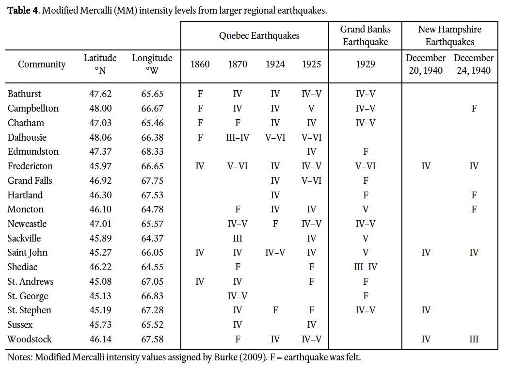
18 During these earthquakes, general shaking of buildings, rattling of dishes and awakening of people was reported in many communities throughout New Brunswick. Intensity levels reached IV–V in many places (Table 4). At some localities, effects associated with intensity levels as high as VI were reported, probably caused by local sites conditions. Such effects were observed in the Fredericton area of New Brunswick, during the 1929 Grand Banks earthquake, approximately 830 km distant (Burke and Slauenwhite 1987). During that event, buildings in the city core, which were sited over thick deposits of glacimarine/glacilacustrine silt and clay, were seen to vibrate more intensely than surrounding areas sited on bedrock with thin glacial cover. For the 1925 Charlevoix earthquake, at places close to the New Brunswick – Quebec border, damage to buildings was reported. Unstable chimneys fell at Campbellton, partitions of walls were separated and glass broken at Dalhousie, and bricks were dislodged from the flue of a chimney in Clearview (Fig. 2). The most significant effect was damage to a chimney in a house in Grand Falls that caused a fire to start and raze the structure. Flow from artesian wells at Newcastle was immediately enhanced aſter the 1925 Quebec earthquake.
 Display large image of Table 4
Paleoseismic Investigations
19 Deterministic studies include the examination of bedrock faults or overlying deformed sediments caused by underling or nearby fault-generated seismic activity (e.g., Reiter, 1990; Tuttle and Seeber, 1991; Clague et al. 1992; Doughty et al. 2010). Such studies can contribute valuable information and enable extrapolation of magnitude, timing and number of seismic occurrences beyond the historical record (e.g., Tuttle et al. 1996; Rajendran 2000). However, caution must be exercised when interpreting suspected tectonic deformation in glaciated areas, where similar-looking structures can be produced by a variety of mechanisms associated with glaciations (i.e., Broster 1991). Examples of two recent studies in New Brunswick are presented below with additional comments on other factors of concern for site assessment.
Saint John, New Brunswick
20 At Saint John, New Brunswick, glacial eroded bedrock with offset striae and grooves had been attributed to post-glacial seismic activity because of the reverse nature of the offsets (Matthew 1894). The offsets occur in Cambrian-Early Ordovician strata, exposed along a prominent valley in the central part of the city (Figs. 6a–c). The displaced glacial striae are most evident in argillite and sandstone of the King Square Formation, latest Middle to early Upper Cambrian in age (Tanoli and Pickerill 1988), which forms the eastern limb of a syncline at the Rock Street location examined by Matthew (1894) and also by Broster and Burke (1990). The orientation of the synclinal axis is approximately parallel to the valley and perpendicular to the orientation of striae.
21 The bedrock surface is polished, grooved and striated (Fig. 6b, c). The striae are oriented southward (to 194° ± 10°) and attributed to the last direction of flow at the end of the Wisconsinan glaciation (Broster and Burke 1990). At the Rock Street location (Fig. 6a), Broster and Burke (1990) recorded 95 offset striae, most showing some reverse movement (northward) along bedding-controlled fractures that could be traced for only tens of metres; 24mm was reported as the maximum single offset (Fig. 6b). Matthew (1894) concluded that the offsets at the Rock Street location represented in total 1.72m of displacement, which would indicate a significant local earthquake if due to a single event. Broster and Burke (1990) observed that some reverse offsets were rounded by glacier overriding and likely contemporaneous with glaciation. They concluded that the displacements represented the response of multi-layered sedimentary rocks with anisotropic strengths, to differential rates of glaciation and unloading, resulting in differential and reverse displacement along bedding planes.
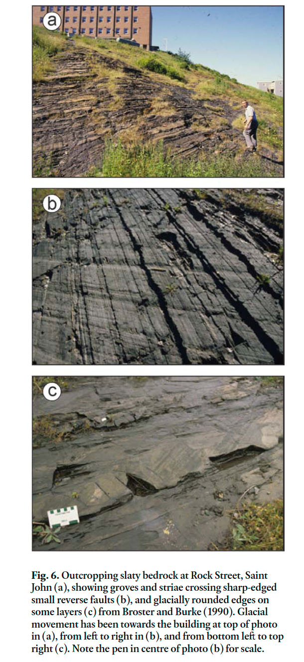 Display large image of Figure 6
Oxbow Settlement Site, Miramichi, New Brunswick
22 Archaeological investigations at the Oxbow Settlement site, Miramichi area in northeastern New Brunswick (see Fig. 2 for location), exposed six deformed structures during excavations to a depth of 2.5m into thinly stratified alluvial silt and sand. The deformation was examined by Broster et al. (1993) and consisted of a variety of structures, including sand expulsions, areas of fluidization, upward-folded, stretched and resedimented layers, fractures, and displaced blocks of layered sediment (Figs. 7a–d). The tops of the deformation structures were disturbed by ploughing that occurred aſter the mid-1800s (Fig. 7d). In the undeformed layrs, projectile points and lead shot (from just below the ploughed zone) delineated a sequence of habitation extending beyond the last 2500 years, as supported by carbon dating. However, in one deformation structure, the clustering of heavy objects lower in the structure and lighter objects higher in the structure, suggested separation by density differences during liquefaction and loss of strength, rather than by anthropogenic reburial. Similar dyke-like sand ‘boils’ or ‘volcanoes’ have been reported near the location of other earthquake events (e.g., Tuttle and Seeber 1991; Bolt 1995; Tuttle 2001).
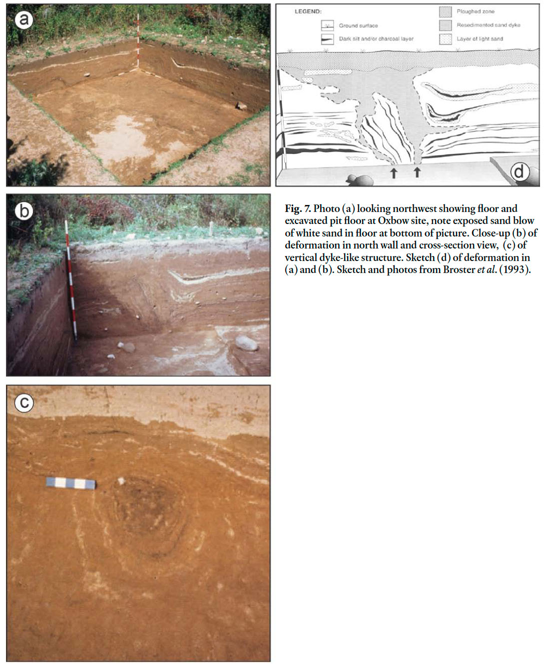 Display large image of Figure 7
23 From examination of newspaper reports for the area and considering the unfrozen state of the ground when disturbed, Broster et al. (1993) deduced that the disturbance was likely the result of the October 22, 1869 earthquake in the Miramichi region. These results support the re-assignment of the epicentre for the 1869 event from the Bay of Fundy to the Central Highlands.
Site Specific Factors
24 While ground-related effects of historical earthquakes have been noted at many locations across the province, communities sited on thick deposits of unconsolidated sediments are most prone to ground disturbance such as amplified ground motion, subsidence and liquefaction.
25 These are sites that represent lake plains, marine plains, flood plains and valleys and include larger urban centres such as Fredericton, Miramichi City (formerly Newcastle and Chatham), Moncton, and parts of Saint John, as well as several other smaller communities (see Tables 2, 4).
26 The sediments underlying Fredericton are typical of the deposits for the larger valleys that were estuaries during deglaciation of the province. These valleys consist of bedrock overlain by till and ice-contact sand and gravel, overlain and deglacial stratified sediments consisting of a waterlain clay-silt unit, underlain and overlain by units of fine to coarse sand and the sequence capped by post-glacial alluvium. The lower sand-rich unit serves as a supply aquifer that is semi-confined and in part, separated from the uppermost alluvial sandy unit by the clay-silt unit. The deglacial sediments were deposited as glaciers retreated up valleys, forming large estuaries and glacial lakes prior to isostatic rebound to current elevations.
27 From drilling at the confluence of Grand Lake and the Saint John River (Dickinson 2008), and in the Saint John River valley, just north of Fredericton (Watson 1970), it has been demonstrated that more than 60m of stratified sand, silt and clay have been deposited in places, with approximately 42m underlying the urban centre of Fredericton (Daigle 2005). A review of geotechnical investigations at Fredericton by Broster (1998) discusses zones within the clay-silt unit that exhibit inherent stiffness, but can change to a low-strength gelatinous state when only slightly disturbed. Analysis by Daigle (2005) of core samples collected from drilling through a 16m thick part of the clay-silt unit between depths of 6m and 22m below surface, found liquidity index ranges of 0.57 to 1.73. Material with values > 1.0 can become viscous if disturbed (Das 2005) resulting in re-sedimentation and possible differential settlement under some structures.
28 Values for shear wave (Vs) seismic interval velocities were obtained by Nadeau (2005) and Nadeau et al. (2004) from three boreholes drilled through the Fredericton sequence of sediments. Shear wave velocities of 100–300 m/s were observed for the uppermost 20–30m of the alluvial sand and the middle clay-silt units. Amplification of ground motion would be expected at sites overlying these low shear wave velocity zones and may explain the larger shaking effects of earthquakes in the downtown area of Fredericton.
29 Minor alteration of springs, rivers and water tables occurs as a result of earthquakes, as mentioned previously, although few effects are permanent. Some wells were reported to have gone dry on Dorchester Island, close to Sackville, as a result of the 1817 earthquake. (see Fig. 2 for locations), whereas in the Miramichi region, new springs appeared and others diminished in flow at the time of the October 20, 1869 earthquake.
30 Movements within the marine sediments, or along steep rock slopes, such as those that border the Bay of Fundy, should be expected during seismic events, although few have been reported. Earthquake-induced mass movements accompanying ground motion of steep slopes have only been reported occasionally in the province. A rock fall occurred on Pickwaiket Mountain, close to Hampton, at the time of the February 8th, 1855 earthquake. At the time of the September 30th, 1937 earthquakes, several rock slides were reported on Sugarloaf Mountain, near Campbellton (Burke 2009).
31 Ruitenberg and McCutcheon (1978) report that on November 26, 1977 a slump occurred in a wedge of marine clay, silt and minor sand overlying fractured bedrock, forming a slope along the south shore of Lorneville Cove, 12km west of Saint John (Fig. 2), that may have been triggered by seismic activity. A weak tremor was reported by a local resident to have occurred around the time of the slump, although an earthquake was not detected by seismometers. The slump occurred aſter heavy rainfall and site factors such as saturated sediments with low shear strength, a steep slope, and continuous erosion of the toe of the slope by tidal currents, likely contributed to the failure.
32 No other reported instances of earthquake-triggered movements in the landslide prone areas of the province have been found. It is possible that other landslips were triggered by earthquakes in the past but went unnoticed because they were not close to populated areas.
33 On November 18, 1929, the magnitude 7.2 earthquake on the Grand Banks produced a tsunami, primarily a result of a landslide at the continental slope (Ruffman 1996, 2005). Although high tides were reported at Chatham and Moncton, these were most likely caused by the storm raging over the province at the time of the earthquake (Burke and Slauenwhite 1987). An extensive review of coastal flooding in Atlantic Canada is presented by Ruffman (1996), but no reports of flooding in New Brunswick as a result of seismic-related wave action were documented. This is likely due to the geographic location of the province, shielded in part from waves generated in the Atlantic by Nova Scotia to the southeast and Prince Edward Island to the east. Poirier (1985) examined the wave patterns that would have been generated by a tsunami from the November 18, 1755 magnitude 7 earthquake, off the coast of Cape Ann, Massachusetts, to the south of the Bay of Fundy. He concluded that they would likely not have presented a threat to New Brunswick’s southern coast, because of the refraction of waves to the coast of southwestern Maine, caused by the shallowing of the water column at the approaches to the Bay of Fundy.
34 The above results are limited in scope and do not consider the possibility of local tsunamis being caused by offshore earthquakes or a bolide falling within the Bay of Fundy, or along the northern and eastern coasts of the province. Ruffman (1991) proposed the possibility of an earthquake source zone off the coast of southwest Nova Scotia. This idea appears to have been based mainly on the transfer of the epicentre of a January 1, 1883 earthquake from the Passamaquoddy Bay region to off the coast of Nova Scotia, although he also cites other Nova Scotia events in 1813 and 1848 as being possibly tsunamigenic. Newspaper reports discovered by Burke (2009) support the relocation of the 1883 earthquake to offshore Nova Scotia, but no reports of local tsunamis or flooding were found for communities along the shores of the Bay of Fundy. However, the following report was found for a Sept 26, 1852 event in the Baie des Chaleurs in the October 2, 1852 issue of the Gleaner and Northumberland, Kent, Gloucester and Restigouche Commercial and Agricultural Journal.
A correspondent writes us to say, that on Sunday week, about half past four in the aſternoon, there was a smart shock of an Earthquake felt in many parts of the County; and at Dalhousie it was accompanied by a subterranean sound, aſter which three or four great waves of the sea came in. Our correspondent adds-"Having felt in the West Indies so many of these things, I knew what the sound was at once, before the shock."
35 This report indicates the possibility of a tsunamigenic earthquake-source off the northern coast of New Brunswick.
36 Seiches could possibly occur on Grand Lake and other small lakes within the province. However, no reports of seiches in New Brunswick were found in the study of historical earthquakes, although the waters of Spruce Lake, close to Saint John were reported as being discoloured at the time of the October 22, 1869 earthquake (Burke 2009).
CONCLUSIONS
37 New Brunswick has been spared many effects of earthquakes that are common to other parts of the world. Potential hazards to the public include; floods from embankment failure, alteration to flow of rivers and springs, mass movements, tsunami along coasts, seiches in lakes, and ground disturbance such as vibration and differential settlement from liquefaction and dewatering. Building vibration is oſten greatest for taller buildings and particularly for structures sited overlying thick deposits of sediment, and causes collapse of walls or fall of architectural features.
38 No location in New Brunswick is completely free of earthquake hazard. The province experiences occasional moderate earthquakes in the magnitude 5 to 6 range, with the areas of most frequent event recurrence being in the Central Highlands, Passamaquoddy Bay and the Moncton sub-zones. These earthquakes have resulted in minor damage to buildings and some effects on natural features. Major historical earthquakes with epicentres outside of the province have resulted in felt intensity levels up to VI at some locations in New Brunswick. Government data banks offer a reasonable but incomplete source for New Brunswick earthquake data due to limited inclusion of seismic events, possible inclusion of occasional non-seismic events, mistaken location of epicentres for some events, and the sparse number of maintained seismometers in the province. Assessment difficulties due to the limitations of the instrument event-record have been assisted by study of historical records and paleoseismic research. Recent examination of historical documents and paleoseismic research indicate that revisions are necessary for some of the listed earthquakes in the NEDB.
39 Results presented here demonstrate that effective and accurate earthquake hazard assessment can only be achieved through considering historical and paleoseismic evidence for recurrence of moderate local earthquakes, as well as the examination of specific site conditions that may be affected by local or larger regional events. Because of the variable terrain slopes and sediment type and thicknesses within each city area, micro-zonation studies are needed to identify areas prone to earthquake-induced hazards such as liquefaction, mass-movements and hydrological change. We suggest that further paleoseismic studies are warranted and evidence should be sought for prehistoric tsunami events.
We wish to thank M. Lamontagne and an anonymous reader for reviews of an earlier manuscript and suggestions. Figures 6a–c were published previously in Atlantic Geology and permission to publish figures 7a–c was granted by Elsevier. Research funding to Broster from the New Brunswick Department of Natural Resources, Geological Survey Branch is gratefully acknowledged.