Articles
U-Pb Age of the Stanley Brook Granite, Grand Manan Island, New Brunswick, Canada
ABSTRACT
The Stanley Brook Granite on Grand Manan Island has yielded an Early Cambrian U-Pb zircon age of 535 ± 2 Ma. The granite was emplaced into sedimentary rocks of the Flagg Cove Formation of the Castalia Group, proving that the latter is no younger than Early Cambrian. Previous dating of detrital zircons from the Flagg Cove Formation limits its maximum depositional age to be no older than 574 ± 7 Ma. The intrusive age of the Stanley Brook Granite is essentially identical to the 539 ± 3 Ma age obtained previously from dacitic tuff of the Priest Cove Formation, suggesting a comagmatic relationship between the two. The contact between the Flagg Cove and Priest Cove formations is invariably faulted. However, the consanguineous relationship between the Priest Cove Formation and Stanley Brook Granite suggests that the Priest Cove Formation was deposited on the Flagg Cove Formation. This proposed stratigraphic relationship supports the interpretation that the tuffaceous and volcaniclastic sedimentary rocks of the Priest Cove Formation represent a distal facies of the mafic flows and fragmental volcanic rocks of the Ross Island Formation. The age of the Stanley Brook Granite is consistent with the interpretation that Mesoproterozoic (?) to Neoproterozoic platformal carbonate rocks of the Brookville terrane represent basement to Neoproterozoic volcanic rocks of the New River terrane.
RÉSUMÉ
L’âge U-Pb sur zircon du granite du ruisseau Stanley, sur l’île Grand Manan, se situerait à environ 535 ± 2 Ma et remonterait au début du Cambrien. Ce granite a été mis en place dans les roches sédimentaires de la Formation de Flagg Cove du groupe de Castalia, ce qui établirait que cette dernière formation date tout au plus du début du Cam-brien. Les travaux de datation précédents des zircons détritiques de la Formation de Flagg Cove ont fixé l’âge maximal de la sédimentation à 574 ± 7 Ma, tout au plus. Pour l’essentiel, l’âge de l’intrusion du granite du ruisseau Stanley correspond à l’âge de 539 ± 3 Ma déjà déterminé pour le tuf dacitique de la Formation de Priest Cove, ce qui donnerait à penser qu’il y a une relation comagmatique entre les deux. La zone de contact entre les formations de Flagg Cove et de Priest Cove est pratiquement toujours faillée. Toutefois, l’origine commune de la Formation de Priest Cove et du granite du ruisseau Stanley porte à croire que la sédimentation de la Formation de Priest Cove s’est superposée à la Formation de Flagg Cove. Ce lien au plan stratigraphique viendrait corroborer l’interprétation voulant que les roches sédimentaires tufacées et volcanoclastiques de la Formation de Priest Cove sont de fait un faciès éloigné des coulées mafiques et des roches volcanoclastiques de la Formation de Ross Island. L’âge établi pour le granite du ruisseau Stanley va dans le sens de l’interprétation voulant que les roches carbonatées dans la succession de plateformes du Mésoprotérozoïque (?) au Néoprotérozoïque du terrane de Brookville forment le socle des roches volcaniques du Néoprotérozoïque du terrane de New River.
[Traduit par la redaction]
INTRODUCTION
1 Complexly deformed, Proterozoic to Early Cambrian rocks, exposed on the eastern coast of Grand Manan Island (Alcock 1948; Fyffe and Grant 2001, 2003), are faulted against Late Triassic to Early Jurassic basaltic flows and redbeds of the Fundy Group, which underlie the western part of the island (Wade and Jansa 1994). Contacts between the various Proterozoic to Early Cambrian formations recognized on Grand Manan Island are generally covered or faulted making determination of the original stratigraphic order of some of these units difficult. To help clarify stratigraphic relationships, a series of samples were collected by the New Brunswick Geological Survey, Acadia University, and the Geological Survey of Canada under a joint geochronological project carried out between 2000 and 2003. The U-Pb ages on magmatic and detrital zircons obtained under this project, including that of the Stanley Brook Granite, have all now been published (Barr et al. 2003; Black et al. 2004; Miller et al. 2007; Fyffe et al. 2009). However, the analytical data used to calculate the age of the Stanley Brook Granite were not included in these publications. This paper presents the supporting radiometric data for the age of the Stanley Brook Granite and discusses the implications of the age determination in regard to the further understanding of the pre-Mesozoic geology of Grand Manan Island and the adjacent New Brunswick mainland.
REGIONAL TECTONIC SETTING
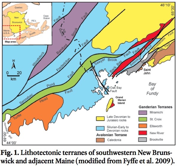
2 Proterozoic basement rocks underlying the southern coastal mainland of New Brunswick have been divided into three distinctive terranes (Fig. 1) based on differences in both stratigraphic and plutonic histories (see Fyffe et al. 2009, and references therein): (1) the Caledonia terrane containing Neoproterozoic continental volcanic-arc rocks of the Broad River Group and comagmatic plutons (625 ± 5 to 616 ± 3 Ma) and younger Coldbrook Group and comagmatic plutons (559 ± 5 to 550 ± 1 Ma); (2) the Brookville terrane containing Mesoproterozoic (?) to Neoproterozoic platformal carbonate and metasiltstone of the Green Head Group; Neoproterozoic volcanic rocks of the Dipper Harbour Group (553 ± 3 Ma), and Neoproterozoic to Early Cambrian plutonic rocks (548 ± 2 to 528 ± 3 Ma); and (3) the New River terrane containing Neoproterozoic and Early Cambrian volcanic rocks of the Belleisle Bay Group (554 ± 3 Ma and 539 ± 5 Ma), and two ages of Neoproterozoic plutons (629 ± 1 to 622 ± 2 Ma, and 555 ± 2 Ma). The Caledonia terrane and Brookville/New River terranes are considered to be part of the peri-Gondwanan microcontinents of Avalonia and Ganderia, respectively (van Staal et al. 1996, 1998; Hibbard et al. 2006).
3 The recently published U-Pb magmatic zircon age determinations from Grand Manan Island (Miller et al. 2007) have confirmed a Neoproterozoic age for much of the bedrock as previously suggested by Alcock (1948). These dates together with the presence of platformal carbonate and quartz-rich sedimentary rocks suggest possible tectonostratigraphic linkages of Grand Manan Island to the Ganderian Brookville and New River terranes on the New Brunswick mainland (Miller et al. 2007; Fyffe et al. 2009) (Fig. 1).
 Display large image of Figure 1
PRE-MESOZOIC GEOLOGY OF GRAND MANAN ISLAND
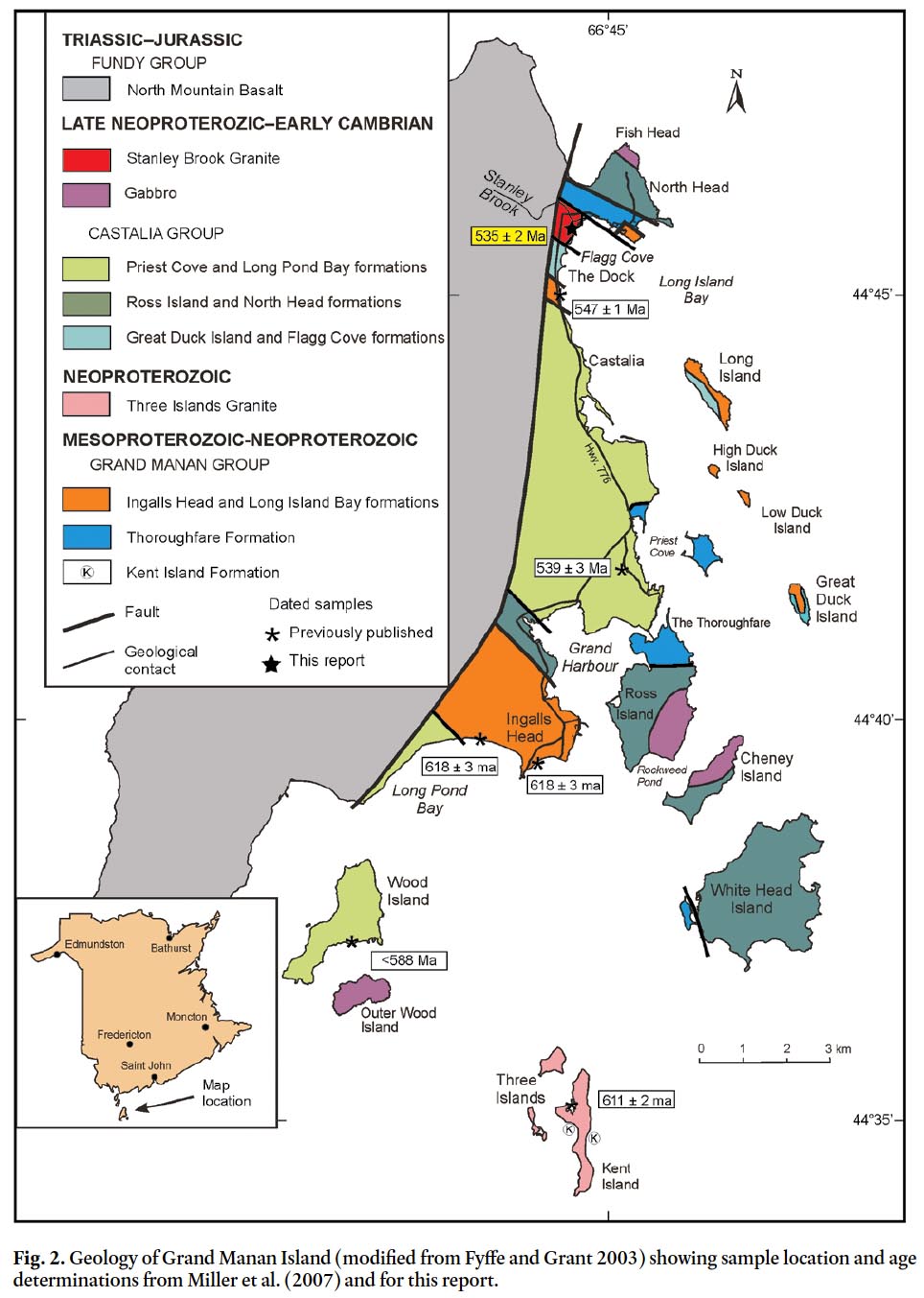
4 Pre-Mesozoic stratified units on Grand Manan and nearby islands consist mainly of quartzose and carbonate sedimentary rocks, and volcanic and reworked volcaniclastic sedimentary rocks. Metamorphic grade generally does not exceed green-schist facies, and in many places, primary sedimentary and igneous textures are well preserved. Formational terminology follows that of Fyffe and Grant (2003) with modifications by Black et al. (2004). Based on exposed and inferred strati-graphic relationships, depositional environments, and U-Pb ages, the formations recognized on Grand Manan and nearby islands are divided into the Mesoproterozoic to Neoproterozoic Grand Manan Group (probable minimum age of 618 ± 3 Ma), and the younger Neoproterozoic to Early Cambrian Castalia Group (probable minimum age of 539 ± 3 Ma). The Grand Manan Group comprises the Kent Island, The Throughfare, Ingalls Head, and Long Island Bay formations; the Castalia Group comprises the Great Duck Island, Flagg Cove, Ross Island, North Head, Priest Cove, and Long Pond Bay formations (Fig. 2).
 Display large image of Figure 2
Grand Manan Group
5 White to buff marble of the Kent Island Formation, which occurs only as large xenoliths in the Neoproterozoic (611 ± 2 Ma) Three Islands Granite (Barr et al. 2003), has been correlated with the platformal carbonates of the Ashburn Formation of the Green Head Group by Alcock (1948), and therefore could be as old as Mesoproterozoic. The Thoroughfare Formation is composed of massive, locally cross-bedded, white quartzite interbedded with black carbonaceous shale. Rare marble and abundant quartzite clasts occur in a cobble conglomerate (a possible correlative of the Great Duck Island Formation, see below) on Gannet Rock to the south of Grand Manan Island. These marble and quartzite clasts may be sourced from the Kent Island and Thoroughfare formations, respectively, suggesting similarity in the ages of the two formations (Miller et al. 2007). However, the mutual stratigraphic relationships of the Kent Island, Thoroughfare, Ingalls Head, and Long Island Bay formations of the Grand Manan Group remain uncertain, although all are older than the Castalia Group.
6 The Ingalls Head Formation, exposed on Grand Manan Island, comprises felsic, intermediate, and mafic tuffs, flows, and breccia, iron formation, and purple laminated mudstone (Pe-Piper and Wolde 2000; Fyffe and Grant 2001, 2003). A felsic flow from this unit yielded a Neoroterozoic U-Pb zircon age of 618 ± 3 Ma (Barr et al. 2003; Miller et al. 2007). Fyffe and Grant (2001, 2003) considered the rocks exposed in a separate belt on Long Island to belong to the Ingalls Head Formation but Black et al. (2004) placed them in the separate Long Island Bay Formation (Fig. 2). The Long Island Bay Formation consists of plagioclase-phyric mafic flows, mafic breccias, graded felsic tuffs, and laminated, purple siltstone. A minimum Late Neoproterozoic age for the Long Island Bay Formation is provided by a U-Pb zircon age of 547 ± 1 Ma reported from the High Duck Island felsic dyke north of Castalia (Black et al. 2004; Miller et al. 2007). The contact of Long Island Bay Formation with the unconformably overlying conglomerate of the Great Duck Island Formation, which defines the base of the Castalia Group, is exposed on the western shore of Long Island (Fig. 2).
Castalia Group
7 The Great Duck Island Formation, exposed on Long and Great Duck islands, is the oldest stratigraphic unit in the Castalia Group (Fyffe and Grant 2001; 2003). It consists of thick-bedded, greyish green to purple, quartz pebble to cobble conglomerate that contains conspicuous clasts of mafic volcanic rocks derived from the plagioclase-phyric flows of the underlying Long Island Bay Formation of the Grand Manan Group. The Great Duck Island Formation is interpreted to correlate with thick-bedded, purple quartz-pebble conglomerate exposed at The Dock in Long Island Bay on Grand Manan Island (Fyffe and Grant 2003). The thick-bedded conglomerate at The Dock is conformably overlain to the north by thin-to medium-bedded, greyish green, quartzose sandstone, siltstone, and dark grey to black siltstone, and minor quartz-pebble conglomerate of the Flagg Cove Formation. Sandstone beds of the Flagg Cove Formation south of Stanley Brook display the trace fossil Planolites, indicating that these strata are no older than Late Neoproterozoic (Pemberton and Frey 1982; Ron Pickerill, personal communication, 2000).
8 The Long Pond Bay Formation, exposed along the coast to the southwest of Ingalls Head (Fig. 2), consists of hyaloclastic mafic volcanic rocks interbedded with locally brecciated, green cherty mudstone. A shallow-water to subaerial sequence of amgydaloidal mafic volcanic rocks interbedded with red arkose and mudstone, and minor felsic volcanic rocks exposed on Wood Island are also included in the Long Pond Bay Formation but their relationship to the deeper water sequence exposed along Long Pond Bay is not known (Fyffe and Grant 2001, 2003; Black et al. 2004). The dominantly mafic volcanic rocks of the Long Pond Bay Formation are separated from the dominantly felsic to intermediate volcanic rocks of the Ingalls Head Formation to the northeast by a sequence of thick-bedded wacke that may represent a facies of the Flagg Cove Formation. Xenocrystic zircons from a felsic volcanic rock on Wood Island provide a maximum age for the Long Pond Bay Formation of ca. 588 Ma (Miller et al. 2007).
9 The Priest Cove Formation includes coarse- to fine-grained mafic tuff, graded volcaniclastic sandstone and laminated silt-stone, and minor dacitic crystal-lithic lapilli tuff (Fyffe and Grant 2001, 2003). The generally coarser, reworked nature of the mafic tuffs suggests that the Priest Cove Formation was deposited in a similar but shallower depositional environment than those of the Long Pond Bay Formation. A dacitic crystal tuff near the central part of the Priest Cove Formation yielded a U-Pb zircon age of 539 ± 3 Ma (Black et al. 2004; Miller et al. 2007), indicative of an earliest Cambrian age.
10 The Ross Island Formation, comprised of massive to fragmental, and pillowed mafic volcanic rocks (Pe-Piper and Wolde 2000; Fyffe and Grant 2001, 2003; Black et al. 2004), may be similar in age to, and in part a proximal lateral facies equivalent of, the mafic tuffs and volcaniclastic sedimentary rocks of the partially reworked Priest Cove Formation (Stringer and Pajari 1981). A conglomerate at the base of the Ross Island Formation contains cobble- to boulder-sized clasts of granite, granitic pegmatite, and micaceous white quartzite set in a mafic volcanic matrix. The granite clasts from the conglomerate yielded K-Ar muscovite ages of 640 Ma and 590 Ma (Lowdon et al. 1963; Leech et al. 1963; Stringer and Pajari 1981). The clasts in the conglomerate are interpreted to have been derived from the Kent Island Granite and quartzite of the Thoroughfare Formation, the latter of which is in faulted contact with the Ross Island Formation on the northern tip of Ross Island and western tip of White Head Island (Fig. 2). The North Head Formation consists of massive mafic volcanic flows and breccia similar to those of the Ross Island Formation.
Stanley Brook Granite
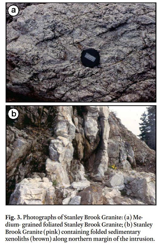
11 The Stanley Brook Granite is exposed for a distance of about 400 m along the shore of Flagg Cove to the south of Stanley Brook (Fig. 2). The granite is light pink, foliated, medium-grained (Fig. 3a), and along its northern boundary contains elongate xenoliths of greyish-green siltstone (Fig. 3b) from a few centimetres to a few metres in length (Fyffe and Grant 2001, 2003). The xenoliths are commonly cross-cut by folded and brecciated veins of pink granite. A zone of phyllonitic granite about two metres wide, trending 175° and dipping 80° west, marks the sheared northern contact with sedimentary rocks of the Flagg Cove Formation. Some of the siltstone xenoliths in the granite contain thin beds of quartzose sandstone identical to those in the adjacent Flagg Cove Formation, suggesting that displacement along the contact is not significant.
 Display large image of Figure 3
12 The southern portion of the Stanley Brook Granite consists of a mixture of intermingled pink granite veins, and hybridized inclusions of greyish green, fine- to medium-grained, plagioclase-phyric diorite. The diorite is speckled with pyrite cubes, and contains abundant quartz crystals in places where it has been largely assimilated by the granite. A northwest-trending brittle fault, exposed in the cliff face along the shore, marks the southern limit of Stanley Brook Granite (Fig. 2). The southeastern projection of the brittle fault truncates a three-metre wide shear zone exposed in the foreshore a short distance to the north. The shear zone, which trends at 30° and dips 70° northwest, separates phyllonitic hydrid rocks containing small (1 cm in length) rounded, cataclastic fragments of granite from adjacent sedimentary rocks of the Flagg Cove Formation to the southeast. This contact is likely continuous in the offshore with the northern sheared contact of the Stanley Brook Granite described above.
GEOCHRONOLOGY
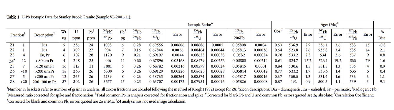
13 A sample of pink, medium-grained granite (Sample VL-2001-11) from the northern part of the exposure of Stanley Brook Granite in Flagg Cove was collected for U-Pb dating at the Geological Survey of Canada facilities in Ottawa. Zircons were analysed using isotope dilution thermal ionization mass spectrometry (ID-TIMS). The rock sample was crushed and heavy mineral separates were obtained using a Wifley table and heavy liquid separation. Different zircon fractions were hand-picked under a binocular microscope aſter separation with a Frantz electromagnetic separator. To minimize the effects of secondary Pb-loss, the air abrasion technique of Krogh (1982) was used for most of the fractions analysed. The selected minerals were washed with 2N HNO3 before weighing and spiking with a 205Pb - 233U - 235U calibrated solution (Parrish and Krogh 1987). Zircon was dissolved with HF and HNO3 in Parrish-type microcapsules in an oven at ca. 240° C (Parrish 1987). U and Pb separation and purification for zircon and monazite followed a scale-down version of the procedure of Krogh (1973). Total procedural blanks are below 1pg U and less than 5 pg Pb.
14 Aſter separation, the U and Pb were loaded for analysis in separate Rhenium filaments. Measurement of the isotopic ratios was done with a Finnigan MAT 261 mass spectrometer equipped with an analog secondary electron multiplier (Roddick et al. 1987). The reported isotopic ratios are corrected for mass fractionation, blank and initial common Pb estimated using the model of Stacey and Kramers (1975). Ages and uncertainties are calculated with error propagation of sources of uncertainty using an internal program from the Geological Survey of Canada (Roddick et al. 1987). The isotopic ages were calculated using the decay constants of Jaffey et al. (1971). U-Pb concordia diagrams were created with ISOPLOT 2.0 (Ludwig 1999). Mixing and discordia lines were calculated with the same program. The uncertainty of the error ellipses is represented at the 2σ level.
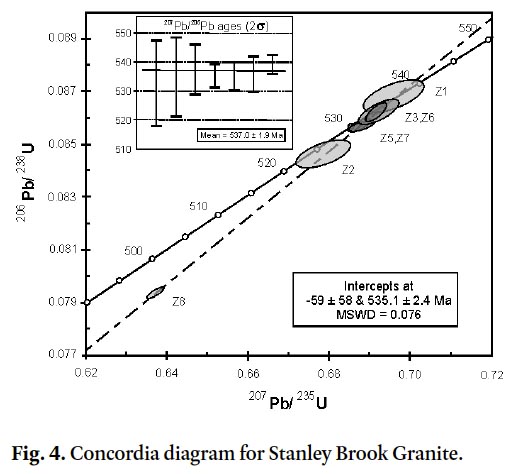
15 The sample of the Stanley Brook Granite yielded a large amount of good quality zircon oſten containing acicular fluid inclusions. Zircon analyses range from single grain to multi-grain fractions (Table 1). All fractions were air abraded to eliminate secondary Pb-loss, except for fraction Z8. Fraction Z8 is composed of small, elongate zircon prisms; this fraction was picked to provide constrains on the discordia line. A total of eight analyses were performed. Fraction Z4 has not been plotted and has been excluded in the age calculation due to the large analytical error (Table 1). This analytical error results from low signal during analysis on the mass spectrometer. The remaining seven fractions define a collinear discordance pattern (Fig. 4). This discordia line has a upper intercept of 535.1 ± 2.4 Ma, and a good probability of fit of 99.6% (MSWD = 0.076) and a lower intercept near the origin. The mean 207Pb/206 Pb age for the seven fractions is 537 ± 2 Ma, which is within error with the upper intercept age (Fig. 4, upper leſt). This is consistent with a discordia line induced by recent Pb-loss, i.e. a discordia passing through the origin of the concordia curve. Therefore, the upper intercept age of 535.1 ± 2.4 Ma is interpreted as the best estimate of the zircon crystallization age of the intrusion.
 Display large image of Table 1
DISCUSSION AND CONCLUSIONS
16 The Stanley Brook Granite is known to have been emplaced into the sedimentary rocks of the Flagg Cove Formation of the Castalia Group based on the presence of xenoliths in the granite. The minimum age of the Flagg Cove Formation is, therefore, Early Cambrian as constrained by the 535 ± 2 Ma emplacement age of Stanley Brook Granite. The Flagg Cove Formation is known on stratigraphic grounds to be no older than the unconformably underlying Long Island Bay and correlative Ingalls Head Formation (dated at 618 ± 3 Ma) of the Grand Manan Group. The maximum stratigraphic age of the Flagg Cove Formation is further constrained to be no older than 574 ± 7 Ma on the basis of its youngest contained detrital zircon population (Fyffe et al. 2009).
17 The Early Cambrian age of the Stanley Brook Granite overlaps within error the 539 ± 3 Ma age of the dacitic tuff from the Priest Cove Formation of the Castalia Group and suggests a possible comagmatic relationship. Although the contact between the Flagg Cove and Priest Cove formations is invariably sheared (Fig. 2), the consanguineous relationship of the Stanley Brook Granite and the felsic tuffs the Priest Cove Formation suggests that the latter was deposited on sedimentary rocks of the Flagg Cove Formation. This supports the proposal by Stringer and Pajari (1981) that the tuffaceous and volcaniclastic sedimentary rocks of the Priest Cove Formation are a distal facies of the mafic flows and fragmental volcanic rocks of the Ross Island Formation, which are also known to be younger than the Grand Manan Group on the basis of contained granitic clasts.
18 The age of 535 ± 2 Ma of the Stanley Brook Granite and the 547 ±1 Ma of the High Duck Island dyke (Black et al. 2004) on Grand Manan Island, and the 542 ± 1 Ma age of the Machias Seal Island Monzodiorite to the southwest of Grand Manan Island (Barr et al. 2010), all overlap with the 548 ± 2 to 528 ± 3 Ma age range of the Neoproterozoic to Early Cambrian plu-tonic rocks of the Brookville terrane on the New Brunswick mainland (White et al. 2002). In addition, carbonate rocks of the Kent Island Formation of the Grand Manan Group closely resemble those of the Green Head Group that characterizes the Brookville terrane, although the latter does not contain any volcanic rocks equivalent in age to Ingalls Head Formation (618 ± 3 Ma) of the Grand Manan Group. However, northward thrusting and upliſt on the Kennebecasis Fault on the eastern side of the Oak Bay Fault (Fig. 1) may explain the absence of older Neoproterozoic volcanic rocks in the Brookville terrane on the mainland (Park et al. 1994). Neoproterozoic granitic plutons (629 ± 1 to 622 ± 2 Ma), which overlap within limits of error with the volcanic rocks of the Ingalls Head Formation, occur in the New River terrane on the mainland (Johnson and Barr 2004; Bartsch and Barr 2005).
19 The Three Islands Granite, which intrudes the Kent Island Formation and has been dated at 611 ± 2 Ma, has no equivalent in the Brookville terrane on the mainland, although an orthogneiss with a an igneous crystallization age of 605 ± 3 Ma is preserved there (Bevier et al. 1990). The Early Cambrian Priest Cove Formation (539 ± 3 Ma) of the Castalia Group is identical in age to volcanic rocks of the Simpsons Island Formation (539 ± 5 Ma) of the Belleisle Bay Group in the New River terrane on the New Brunswick mainland. However, no older volcanic rocks of ca. 550 Ma ages, common elsewhere in the New River terrane, have been identified on Grand Manan Island.
20 The above overlapping age determinations between Grand Manan Island and the New Brunswick mainland are consistent with the interpretation that the carbonate and clastic rocks of the Green Head Group in the Brookville terrane represent basement to the New River terrane (van Staal et al. 1996; 1998; Barr et al. 2003; Miller et al. 2007; Fyffe et al. 2009; Barr et al. 2010). Moreover, the actual basement-cover relationship may be marked by the unconformity between volcanic rocks of the Grand Manan Group and sedimentary rocks of the Castalia Group exposed on Great Duck Island. Therefore, the separation of the Brookville and New River terranes into distinctive co-linear fault blocks like that on the New Brunswick mainland, may not be applicable on Grand Manan Island.
Terry Leonard and Erin Smith prepared the figures. Malcolm McLeod and Susan Johnson provided helpful comments on an early draſt of the manuscript. Georgia Pe-Piper and an anonymous reviewer are thanked for their insightful suggestions for improving the manuscript.