Articles
Age and petrology of the Machias Seal Island quartz monzodiorite, the southernmost rocks in New Brunswick, Canada
Sandra M. BarrDepartment of Earth and Environmental Science, Acadia University, Wolfville, Nova Scotia B4P 2R6, Canada
sandra.barr@acadiau.ca
James K. Mortensen
Department of Earth and Ocean Sciences, University of British Columbia, Vancouver, British Columbia V6T 1Z4, Canada
Chris E. White
Nova Scotia Department of Natural Resources, P.O. Box 698, Halifax, Nova Scotia B3J 2T9, Canada
Richard M. Friedman
Department of Earth and Ocean Sciences, University of British Columbia, Vancouver, British Columbia V6T 1Z4, Canada
Date received: 08 June 2010 ¶ Date accepted: 08 September 2010 ¶ Date digitally published: 12 October 2010doi:10.4138/atlgeol.2010.009
ABSTRACT
Machias Seal Island in the northern Gulf of Maine consists of fine- to medium-grained weakly foliated quartz monzodiorite. Although previously inferred to be as young as Devonian, the quartz monzodiorite yielded an Ediacaran–Early Cambrian U-Pb (zircon) age of 542.0 ± 0.9 Ma. Typical Machias Seal Island quartz monzodiorite contains strongly zoned plagioclase (50%), about 30% mafic minerals (biotite and amphibole with relict cores of both orthoand clinopyroxene, and 20% interstitial quartz and orthoclase. The average chemical composition (5 samples) has 60.6% SiO2, with relatively high Al2O3 (over 16%) and low K2O (2.8%). Overall, the chemical characteristics, including low Rb, Y, and Nb, are consistent with emplacement in a continental margin subduction zone. The quartz monzodiorite contains abundant ovoid metadioritic enclaves, likely of cognate origin. Age and compositional similarities strongly suggest correlation of Machias Seal Island quartz monzodiorite with the abundant ca. 550–525 Ma gabbroic to granitic plutons of the Brookville terrane on the mainland of southern New Brunswick. Its age is similar also to the ages of volcanic and some plutonic rocks on Grand Manan Island and in the New River terrane in mainland southern New Brunswick, strengthening the interpretation that all of these areas are part of Ganderia. Hence the Fundy Fault southeast of Machias Seal Island likely marks the boundary between Ganderia and Avalonia in the Gulf of Maine.RÉSUMÉ
L’île Machias Seal, dans la partie nord du golfe du Maine, se compose de monzodiorite quartzique à grains fins à moyens faiblement feuilletée. Même si on déjà présumé que son origine remonterait au Dévonien, une datation de la monzodiorite quartzique par la méthode U-Pb sur zircon a indiqué un âge d’Ediacara et du début du Cambrien, soit de 542,0 ± 0,9 Ma. Les minéralisations caractéristiques de monzodiorite quartzique de l’île Machias Seal renferment un plagioclase fortement zoné (50 p. 100), environ 30 p. 100 de minéraux mafiques (biotite et amphibole accompagnées de noyaux résiduels d’orthopyroxène et de clinopyroxène), ainsi que 20 p. 100 de quartz et d’orthoclase interstitiels. La composition chimique moyenne (5 échantillons) est de 60,6 p. 100 de SiO2, une teneur relativement élevée de Al2O3 (plus de 16 p. 100) et une faible teneur en K2O (2,8 p. 100). Dans l’ensemble, les caractéristiques chimiques de ces minéralisations, y compris la faible teneur en Rb, Y et Nb, sont généralement associées à un emplacement dans une zone de subduction de la marge continentale. La monzodiorite quartzique contient d’abondantes quantités d’enclaves de métadiorite ovoïdes, vraisemblablement de la même origine. L’âge et les similitudes de composition de ces roches portent à croire qu’une corrélation pourrait s’établir entre la monzodiorite quartzique de l’île Machias Seal et la grande quantité de plutons gabbroïque à granitique de 550–525 Ma observée dans le socle de Brookville, dans la partie continentale du Sud du Nouveau-Brunswick. Par ailleurs, ces roches ont le même âge que celui des roches volcaniques et de certains plutons de l’île Grand Manan et du socle de New River dans la partie continentale du Sud de la province, ce qui viendrait confirmer l’interprétation voulant que toutes ces zones fassent partie de Ganderia. La faille de Fundy au sud-est de l’île Machias Seal marque donc la limite entre Ganderia et Avalon dans le golfe du Maine.[Traduit par la redaction]INTRODUCTION
1 Machias Seal Island is located at the mouth of the Bay of Fundy, about 20 km southwest of Grand Manan Island and 30 km southeast of Machias, Maine (Fig. 1). The small rocky island is barren except for a lighthouse and dwellings maintained by the Government of Canada, although ownership of the island is disputed between Canada and the United States of America (e.g., Schmidt 2002). The island has the last occupied lighthouse in the Maritime Provinces, and is well known among bird-watchers as a nesting site for puffin, auk, and other seabirds. In addition to its political significance, Machias Seal Island is important geologically because of its location in an area through which it is difficult to trace terranes from Nova Scotia and New Brunswick into the New England states (Fig. 1). Geological studies on nearby Grand Manan Island (Fig. 1) have not resolved that problem, as rocks there have equivocal terrane affinity (e.g., Miller et al. 2007; Fyffe et al. 2009). However, they most resemble those of the New River terrane of southern New Brunswick, suggesting that the Ganderian Kingston and Brookville belts, as well as Avalonia and Meguma, all lie out-board of Grand Manan Island (Fig. 1).
2 Because of its small size, most regional geological maps (e.g., Hibbard et al. 2006) do not show Machias Seal Island. More detailed local maps have shown the island as Precambrian granite (e.g., Potter et al. 1979) or Silurian–Devonian granite (e.g., McLeod et al. 1994; New Brunswick Department of Natural Resources 2010). The purpose of this paper is to describe the petrology of a suite of granitoid samples collected from the island, present a new U-Pb zircon age for the suite, and use these results to interpret the most likely correlative units in the region.
GEOLOGY OF MACHIAS SEAL ISLAND
3 With the exception of grassy areas in the central part of the island, outcrop is continuous on Machias Seal Island (Fig. 2). The rocks are grey to locally pink, fine- to medium-grained, weakly foliated quartz monzodiorite with abundant dioritic enclaves, generally less than 20 cm in diameter. The quartz monzodiorite is cut by two steeply dipping mafic dykes, each about 1 m in width, which trend at about 015° across the island (Fig. 2). The eastern dyke is alkalic, and contains pseudo-morphs of olivine phenocrysts in a fine-grained groundmass of plagioclase, brown amphibole, and pyroxene. The other dyke is more altered and consists mainly of plagioclase, pyroxene, and their alteration products. The age of these dykes is unknown, other than being younger than the quartz monzodiorite.
Fig. 1. Simplified geological map of the area around the Bay of Fundy and Gulf of Maine, showing the location of Machias Seal Island (modified from Hibbard et al. 2006). CCFZ = Cobequid-Chedabucto fault zone. The inset map shows a terrane map of the northern Appalachian orogen, also modified after Hibbard et al. (2006), with the approximate location of the main map indicated by a rectangle.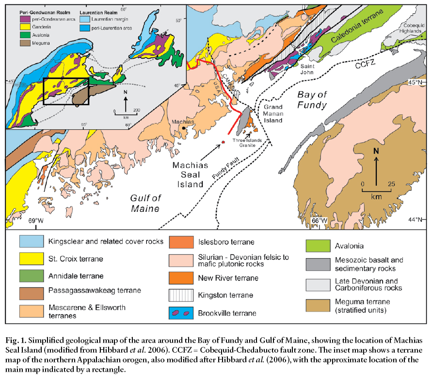
Display large image of Figure 1
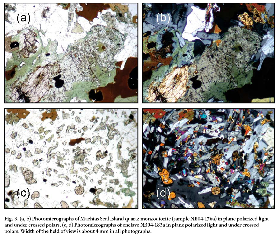
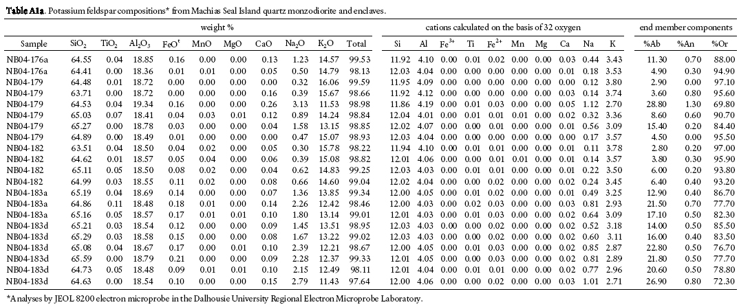
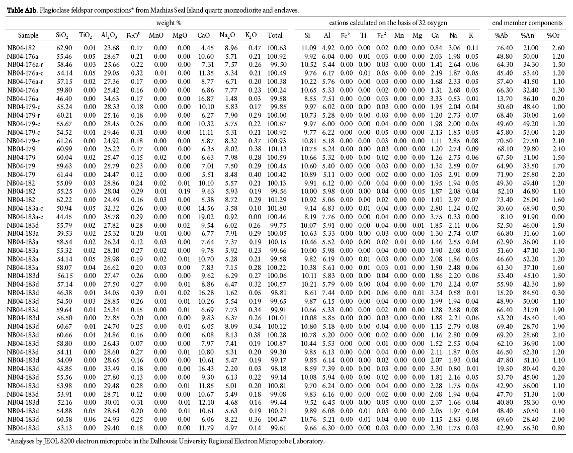
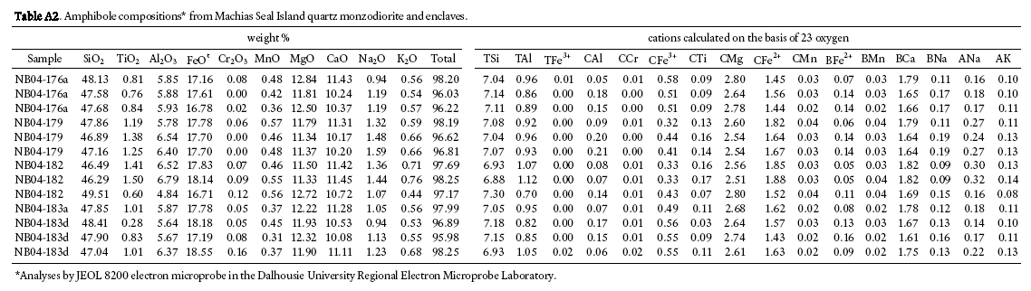
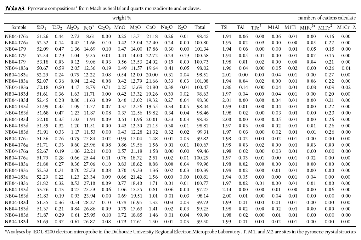
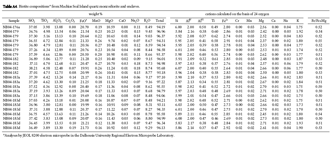
4 Typical Machias Seal Island quartz monzodiorite contains 50% strongly zoned plagioclase, 30% mafic minerals and about 20% interstitial quartz and K-feldspar (Figs. 3a, b). Plagioclase is strongly zoned from labradorite to oligoclase, based on petrographic determinations using extinction angles and on electron microprobe analyses in 3 samples (Fig. 4a). The most abundant mafic mineral is green amphibole of magnesio-hornblende composition (Fig. 4b). The larger amphibole grains typically contain relict cores of both orthopyroxene and clinopyroxene, with the clinopyroxene rimming the orthopyroxene. The orthopyroxene is somewhat less magnesian than the coexisting clinopyroxene (Fig. 4c). Brown biotite occurs in association with amphibole and as separate grains. In both modes of occurrence, its composition is intermediate between phlogopite and annite, with relatively low aluminum content, and it plots in the field for calc-alkalic orogenic suites in the ternary MgO-FeOt-Al2O3 discrimination diagram (Fig. 4d) of Abdel-Rahman (1992). Apatite, zircon (see description below), and magnetite are the most abundant accessory phases.
5 The enclaves are finer grained than their host rocks and of more mafic (dioritic) composition. They consist of plagioclase laths, orthopyroxene, clinopyroxene, amphibole, and biotite in a groundmass of plagioclase and K-feldspar (Figs. 3c, d). In contrast to the host monzodiorite, quartz is minor or absent in the enclaves. The compositions of the mafic minerals in the enclaves are similar to those in the host quartz monzodiorite (Fig. 4b, c, d), although the plagioclase is generally more calcic, up to An90 (Fig. 4a).
GEOCHRONOLOGY
6 A sample of quartz monzodiorite (#182) from the eastern side of the island (Fig. 2) was collected for dating at the Pacific Centre for Isotopic and Geochemical Research (PCIGR). Zircons were separated using conventional crushing, grinding and wet shaking table methods, followed by heavy liquid and magnetic separation. The sample yielded abundant zircons, comprising clear, colorless to pale yellow, stubby square prisms (length:width ratios of 1-2) with simple terminations. Some of the grains were fractured; however, no internal zoning or inherited cores were observed under a binocular microscope or in transmitted light.
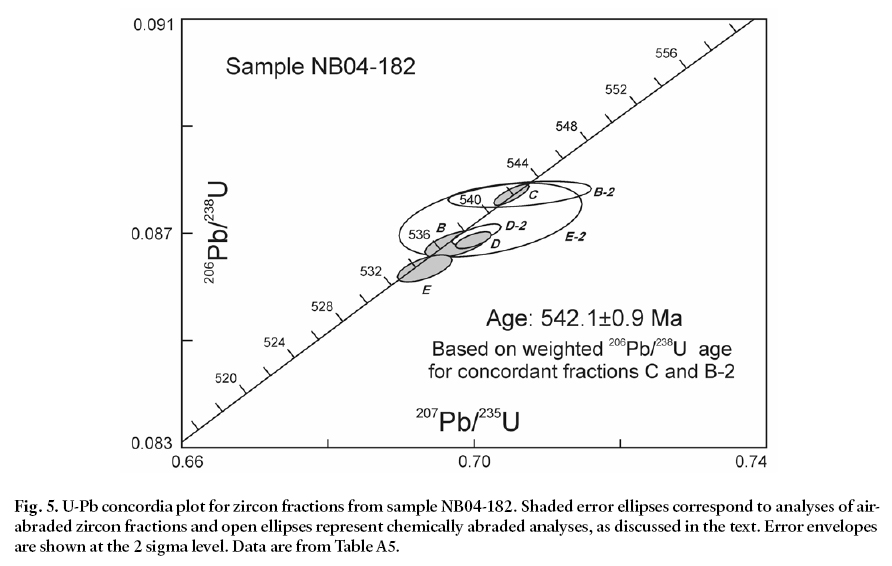
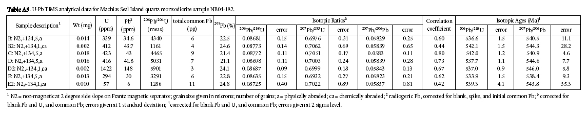
7 Methods used for U-Pb zircon analysis using ID-TIMS techniques at the PCIGR are described by Mortensen et al. (1995). Individual zircon fractions for analysis comprised 1 to 11 grains. U-Pb analytical data are listed in Table A5, and are shown on a conventional concordia plot in Figure 5. Four multigrain fractions of zircon (fractions B, C, D, E) were analyzed initially. The outer portions of these zircon grains had been strongly air abraded prior to dissolution in an attempt to minimize the effects of post-crystallization Pb-loss. The four analyses defined a short linear array that suggested an upper intercept age of approximately 542 Ma; however, there is significant scatter in the data and only analysis C is concordant (Fig. 5). In an attempt to obtain replicate concordant analyses and thus more confidently constrain the age of the rock, three additional zircon fractions were analyzed (B2, D2, E2). These analyses are of single zircon grains that were “chemically abraded” prior to dissolution. The chemical abrasion process involves thermally annealing the grains and then subjecting them to a strong leaching step in concentrated hydrofluoric acid; this procedure has been shown to remove most portions of zircon grains that have been altered or otherwise disturbed, and in many cases produces more concordant and reproducible analyses (see discussion of the chemical abrasion technique as used in the PCIGR in Scoates and Friedman 2008). Two analyses of the chemically abraded zircons still show minor discordance, suggesting that in those cases not all of the altered and disturbed portions of the grains were removed by the process. One of the analyses (B2), however, yields a concordant analysis that completely overlaps with air-abraded fraction C (Fig. 5). A regression of all of the data gives calculated upper and lower intercept ages of 541.9 ± 3.5 Ma and -125 ± 680 Ma, respectively (MSWD = 0.61; probability of fit = 0.69). A regression of all seven analyses forced through the origin yields an upper intercept age of 542.5 ± 2.9 Ma (MSWD = 0.53; probability of fit = 0.79). We consider the best estimate for the crystallization age of the sample, however, to be given by a weighted average of 206Pb/238U ages for the two concordant analyses (C and B2), at 542.0 ± 0.9 Ma.
Fig. 2. Sketch map of Machias Seal Island, modified from Schmidt (2002), showing sample locations. Slash pattern indicates continuous outcrop along the shoreline. Thick dark lines are mafic dykes. Shaded area indicates mainly grass-covered central part of the island.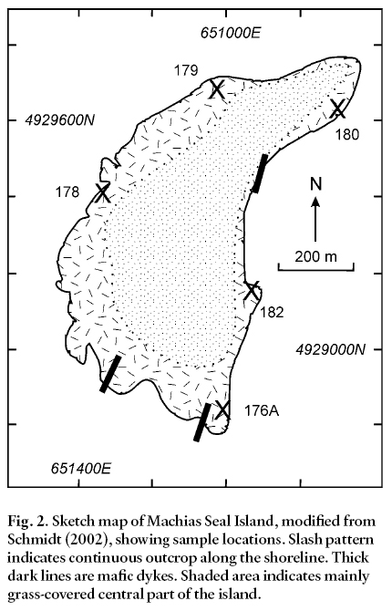
Display large image of Figure 2
Display large image of Figure 3
8 This age coincides closely with the Ediacaran-Cambrian boundary (Walker and Geissman 2009) and is much older than the Early Devonian age previously inferred for intrusive rocks on the island on current maps (e.g., New Brunswick Department of Natural Resources 2010). Regionally, it falls within the range of U-Pb (zircon) ages obtained from numerous plutons in the Brookville terrane of southern New Brunswick (Fig. 6; e.g., White et al. 2002). It is also similar to the ages of some units in the New River terrane (Fig. 6) and three units on nearby Grand Manan Island: High Duck Island Granite (547.3 ± 1.1 Ma; Miller et al. 2007), tuff in the Priest Cove Formation (539 ± 3.3 Ma; Miller et al. 2007), and the Stanley Brook granite (535 ± 2.5 Ma; P. Valverde-Vaquero, unpublished written report to L.R. Fyffe, 2003). The similarity between Grand Manan Island and the New River terrane in rock types, Sm-Nd isotopic characteristics, and ages has been used to infer a link between those two areas, and for including both of them, as well as the Brookville terrane, in Ganderia (Barr et al. 2003; Miller et al. 2007; Fyffe et al. 2009). As documented in detail by Barr et al. (2003) and also discussed in subsequent papers (e.g., Miller et al. 2007; Fyffe et al. 2009), differences in rock types and ages indicate that none of these areas is likely to be related to the Avalonian Caledonia terrane.
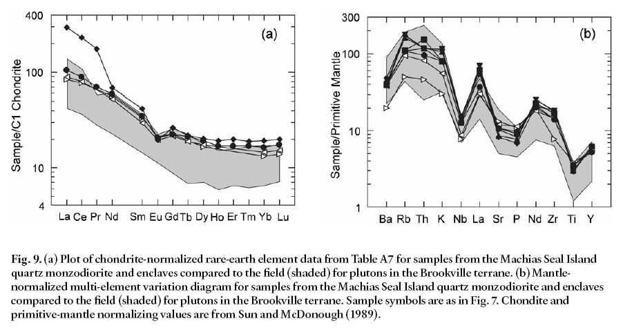
Fig. 4. Mineral compositions determined by electron microprobe. (a) Feldspar in terms of An-Ab-Or components (data from Table A1a, b). (b) Amphibole compositions in terms of tetrahedral Si and Mg/Mg+Fe2+ with fields from Leake et al. (1997) (data from Table A2). (c) Pyroxene compositions in terms of Ca-Mg-Fe end members (data from Table A3). (d) Biotite compositions plotted on the MgO-FeO-Al2O3 discrimination diagram of Abdel-Rahman (1992) (data from Table A4).Fig. 5. U-Pb concordia plot for zircon fractions from sample NB04-182. Shaded error ellipses correspond to analyses of air-abraded zircon fractions and open ellipses represent chemically abraded analyses, as discussed in the text. Error envelopes are shown at the 2 sigma level. Data are from Table A5.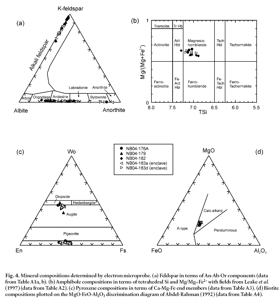
GEOCHEMISTRY
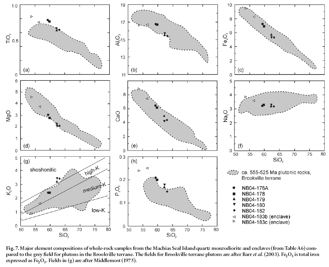
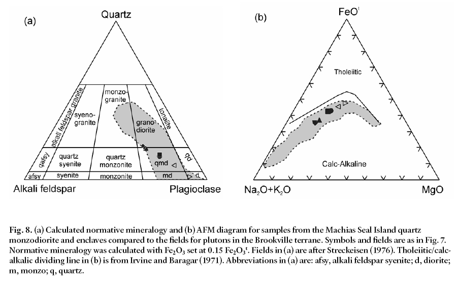
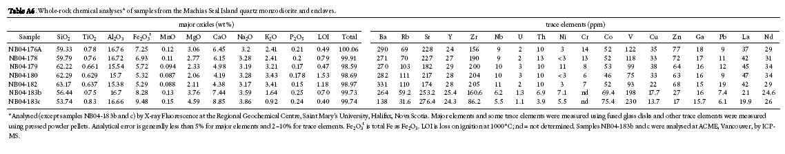
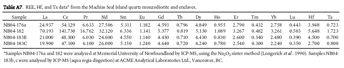
9 Chemical analyses were obtained for 5 samples of the Machias Seal Island quartz monzodiorite and 2 samples from its dioritic enclaves. The quartz monzodiorite samples range in SiO2 content from 59% to 63%, whereas the enclaves have lower SiO2 (56% and 54%) (Fig. 7). A plot of CIPW normative compositions (Fig. 8a) is consistent with the names assigned on the basis of modal estimates (diagram not shown). The enclaves and their host rocks tend to lie on linear trends in major element compositions (Fig. 7, 8b), suggesting that they are linked by crystal fractionation processes. Chondrite-normalized rare-earth element (REE) patterns are also similar in enclave samples and quartz monzodiorite sample NB04-176a, the most mafic of the analyzed quartz monzodiorite samples. The most felsic sample, NB04-182, shows higher REE, especially light REE, and a larger negative Eu anomaly consistent with feldspar fractionation (Fig. 9a). A multi-element comparison diagram also shows similarity between enclaves and host quartz monzodiorite samples, and a trend toward increasing incompatible element abundance with increasing silica content in the samples (Fig. 9b).
10 Because the age obtained for the quartz monzodiorite falls within the range of ages reported for Brookville terrane plutons (Fig. 6), and some of those plutons include similar monzodioritic rock types (e.g., White et al. 2002), fields are shown on the geochemical diagrams for those plutons (Figs. 7-9). In most cases the Machias Seal Island samples plot within the fields defined by the Brookville terrane plutons, and display similar trends, consistent with magma evolution dominated by crystal fractionation of plagioclase and mafic minerals. The REE patterns are also similar, although the Machias Seal Island enclave samples plot at the uppermost part of the range for plutons of the Brookville terrane, and the dated sample lies well above the range. The cause of this difference is not apparent in the mineralogy of the samples.
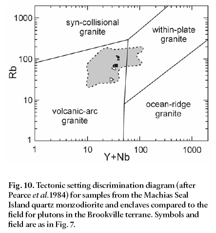
11 The Machias Seal Island samples have chemical features consistent with origin in a continental margin subduction zone (Fig. 10), an interpretation also made for the Brookville terrane plutons in earlier studies (White et al. 2002).
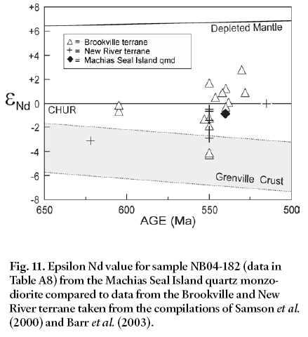
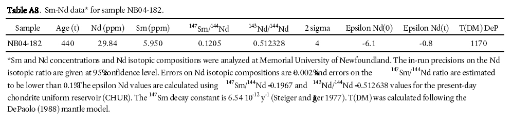
12 The epsilon Nd value of -1, calculated at 540 Ma (Table A8), is similar to that of many samples in the Brookville and New River terranes (Fig. 11). The tendency for igneous units to have negative epsilon Nd values is considered to be one of the characteristic features of Ganderia (Kerr et al. 1995; Samson et al. 2000; Barr et al. 2003).
REGIONAL IMPLICATIONS
13 The similarity in both age and petrology of the Machias Seal Island quartz monzodiorite to plutons of the Brookville terrane supports the interpretation that Machias Seal Island is part of the Brookville terrane. Although it is the closest land area to Machias Seal Island, none of the rocks on Grand Manan Island is similar in age and petrological characteristics to the Machias Seal Island quartz monzodiorite. Much of Grand Manan Island is composed of Mesozoic basalt, and the remaining third of the island is dominated by volcanic and sedimentary rocks (Fyffe and Grant 2005; Black 2005; Miller et al. 2007). The Three Islands Granite forms islands south of the main island, but it has been dated at 611 Ma, much older than the ca. 540 Ma Machias Seal Island quartz monzodio-rite. Two small plutons on Grand Manan Island have yielded Ediacaran-Early Cambrian ages of 547.3 ± 1.1 Ma (Miller et al. 2007) and 535 ± 2.5 Ma (P. Valverde-Vaquero, unpublished written report to L.R. Fyffe, 2003), similar to the age of the Machias Seal Island quartz monzodiorite, but both are granitic in composition and hence petrologically unlike the quartz monzodiorite (Black 2005).
Fig. 6. Compilation of U-Pb (zircon) crystallization ages from igneous units in the Caledonia, Brookville, and New River terranes, as well as Grand Manan Island (New River terrane?), compared to the new age reported here for Machias Seal Island quartz monzodiorite (in horizontal shaded band). Vertical dashed line indicates the Ediacaran-Cambrian boundary after Walker and Geissman (2009). Vertical shaded band indicates range of ages for plutons of the Brookville terrane. Data are compiled from Currie and Hunt (1991), Bevier and Barr (1990), Bevier et al. (1990), Barr et al. (1994, 2000, 2003), White et al.(2002), Currie and McNicoll (1999), Johnson et al. (2009), and McLeod et al. (2003). Unit abbreviations (alphabetical): BB, Bonnell Brook Granite; BC, Brittain Creek Pluton; BG, Brookville Orthogneiss; BH, Blacks Harbour Granite; CM, Caledonia Mountain Gabbro; DHF, Dipper Harbour Formation; DL, Duck Lake Gabbro; FV, French Village Quartz Diorite; Fv, Fairville Granite; GBF, Grant Brook Formation; HDI, High Duck Island Granite; HH, Harvey Hill Granite; HS, Hanson Stream Granite; IHF, Ingalls Head Formation; KH, Kent Hills Granodiorite; LBF, Lobster Brook Formation; LHF, Leavitts Head Formation; LL, Ludgate Lake Granodiorite; LM, Lutes Mountain Quartz Diorite; LP, Lingley Pluton; ML, Millican Lakes Granodiorite; MLv, Mosquito Lake volcanics; MP, McCarthy Point Granodiorite; Mq, Musquash Harbour Pluton; MS, Mechanic Settlement Pluton; OSR, Old Shepody Road Granite; PCF, Priest Cove Formation; PR, Pollett River Granodiorite; RF, Ragged Falls Pluton; RP, Renforth Pluton; SBG, Stanley Brook Granite; SIF, Simpsons Island Formation; TIG, Three Island Granite; UM, Upham Mountain Granite.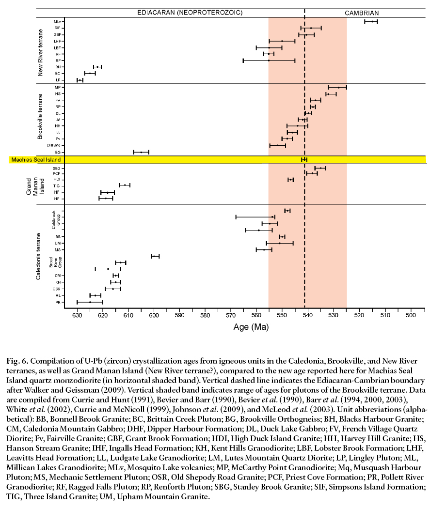
Display large image of Figure 6
Display large image of Figure 7
Display large image of Figure 8
Display large image of Figure 9
Display large image of Figure 10
Display large image of Figure 11
14 The assemblage of pre-Mesozoic rocks on Grand Manan Island and their ages led to tentative correlation with the New River terrane in mainland New Brunswick (Miller et al. 2007; Fyffe et al. 2009). The relationship between the New River and Brookville terranes is uncertain, although both are interpreted to be part of Ganderia. The position of Machias Seal Island so close to Grand Manan Island supports the interpretation that both Brookville and New River terranes are part of Ganderia, whereas Avalonia is located farther offshore (Fig. 1). Geophysical data from the area (e.g., Hutchinson et al. 1988; Keen et al. 1991) are not sufficiently detailed to enable resolution of these details, but the results of this study are consistent with the interpretation that the Fundy Fault, previously identified to the southeast on the basis of geophysical data, marks the boundary between Ganderia and Avalonia (Fig. 1).
15 Overall, the results of this study show that the geology of Machias Seal Island is closely linked to that of mainland New Brunswick, not adjacent parts of Maine. The latter area is dominated by Silurian–Devonian granitoid rocks of the Coastal Maine magmatic province (e.g., Hogan and Sinha 1989).
CONCLUSIONS
16 Machias Seal Island is composed of plutonic rocks of similar age and petrological features to those of the Brookville terrane in mainland southern New Brunswick. They are more than 100 million years older than the granitoid rocks that characterize the Coastal Maine magmatic province, with which they had previously been correlated. Although direct links with rock units exposed on nearby Grand Manan Island cannot be made, some units there are of similar age, supporting Ganderian affinity for both areas.
APPENDIX
Table A1a. Potassium feldspar compositions* from Machias Seal Island quartz monzodiorite and enclaves.
Display large image of Table 1
Table A1b. Plagioclase feldspar compositions* from Machias Seal Island quartz monzodiorite and enclaves.
Display large image of Table 2
Table A2. Amphibole compositions* from Machias Seal Island quartz monzodiorite and enclaves.
Display large image of Table 3
Table A3. Pyroxene compositions* from Machias Seal Island quartz monzodiorite and enclaves.
Display large image of Table 4
Table A4. Biotite compositions* from Machias Seal Island quartz monzodiorite and enclaves.
Display large image of Table 5
Table A5. U-Pb TIMS analytical data for Machias Seal Island quartz monzodiorite sample NB04-182.
Display large image of Table 6
Table A6. Whole-rock chemical analyses* of samples from the Machias Seal Island quartz monzodiorite and enclaves.
Display large image of Table 7
Table A7. REE, Hf, and Ta data* from the Machias Seal Island quartz monzodiorite and enclaves.
Display large image of Table 8
Table A8. Sm-Nd data* for sample NB04-182.
ACKNOWLEDGMENTS
Sandra Barr’s research in New Brunswick is funded mainly by discovery grants from the Natural Sciences and Engineering Research Council of Canada. Funding for the dating component of this study was provided by the New Brunswick Department of Natural Resources. We thank the staff of the PCIGR at UBC for assistance in producing the U-Pb results reported in this contribution.REFERENCES
Abdel-Rahman, A. M. 1992. Nature of biotites from alkaline, calc-alkaline and peraluminous magmas. Journal of Petrology, 35, pp. 525–541.
Barr, S.M., Bevier, M.L., White, C.E., and Doig, R. 1994. Magmatic history of the Avalon terrane of southern New Brunswick, Canada, based on U-Pb (zircon) geochronology. Journal of Geology, 102, pp. 399–409. doi:10.1086/629682
Barr, S.M., Hamilton, M.A., White, C.E., Samson, S.D. 2000. A Late Neoproterozoic age for the Caledonia Mountain Pluton, a high Ti-V layered gabbro in the Caledonia (Avalon) terrane, southern New Brunswick. Atlantic Geology, 36, pp. 157–166.
Barr, S.M., White, C.E., and Miller, B.V. 2003. Age and geo-chemistry of Late Neoproterozoic and Early Cambrian igneous rocks in southern New Brunswick: similarities and contrasts. Atlantic Geology, 39, pp. 55–73.
Bevier, M.L. and Barr, S.M. 1990. U‑Pb age constraints on the stratigraphy and tectonic history of the Avalon terrane, New Brunswick, Canada. Journal of Geology, 98, pp. 53‑63. doi:10.1086/629374
Bevier, M.L., White, C.E., and Barr, S.M. 1990. Late Precambrian U-Pb ages for the Brookville Gneiss, southern New Brunswick. Journal of Geology, 98, pp. 955–965. doi:10.1086/629464
Black, R. 2005. Pre-Mesozoic geology of Grand Manan Island, New Brunswick. Unpublished M.Sc. thesis, Acadia University, Wolfville, Nova Scotia, Canada, 227p.
Currie, K.L., and Hunt, P.A. 1991. Late Precambrian activity near Saint John, New Brunswick, in Radiogenic Age and Isotopic Studies. Report 4, Geological Survey of Canada, Paper 90-2, pp. 11–17.
Currie, K.L., and McNicoll, V.J. 1999. New data on the age and geographic distribution of Neoproterozoic plutons near Saint John, New Brunswick. Atlantic Geology, 35, pp. 157–166.
DePaolo, D.J. 1988. Neodymium isotope geochemistry. New York, Springer-Verlag, 187p.
Fyffe, L.R., and Grant, R.H. 2005. Geology of Grand Manan Island (parts of NTS 21B/10 and B/15), New Brunswick. New Brunswick Department of Natural Resources and Energy, Minerals, Policy, and Planning Division, Plate 2005-24, scale 1:20 000.
Fyffe, L.R., Barr, S.M., Johnson, S.C., McLeod, M.J., McNicoll, V.J., Valverde-Vaquero, P., van Staal, C.R., and White, C.E. 2009. Detrital zircon ages from Neoproterozoic and Early Paleozoic conglomerate and sandstone units of New Brunswick and coastal Maine: Paleogeographic implications for Ganderia and the continental margin of Western Gondwana. Atlantic Geology, 45, pp. 110–144.
Hibbard, J.P., van Staal, C.R., Rankin, D., and Williams, H. 2006 Lithotectonic map of the Appalachian orogen (north), Canada-United States of America. Geological Survey of Canada Map 02041A, scale 1:1 500 000.
Hogan, J.P., and Sinha, A.K. 1989. Compositional variation of plutonism in the Coastal Maine Magmatic Province: mode of origin and tectonic setting. In Studies in Maine geology -igneous and metamorphic geology. Edited by R. D. Tucker and R. G. Marvinney, 4, pp. 1–33.
Hutchinson, D.R., Klitgord, K.D., Lee, M.W., and Trehu, A.M. 1988. U.S. Geological Survey deep seismic profile across the Gulf of Maine. Geological Society of America Bulletin, 100, pp. 172–184. doi:10.1130/0016-7606(1988)100<0172:USGSDS>2.3.CO;2
Irvine, T.N., and Baragar, W.R.A. 1971. A guide to the chemical classification of the common volcanic rocks. Canadian Journal of Earth Sciences, 8, pp. 523–548.
Johnson, S.C., McLeod, M.J., Fyffe. L.R., and Dunning G.R. 2009. Stratigraphy, geochemistry, and geochronology of the Annidale and New River belts, and the development of the Penobscot arc in southern New Brunswick. In Geological Investigations in New Brunswick for 2008. Edited by G.L. Martin. New Brunswick Department of Natural Resources, Minerals, Policy, and Planning Division, Mineral Resources Report 2009-2, pp. 141–218.
Keen, C. E., Kay, W. A., Keppie, J. D., Marillier, F., Pe-Piper, G., and Waldron, J. W. F. 1991. Deep seismic reflection data from the Bay of Fundy and Gulf of Maine: tectonic implications for the northern Appalachians. Canadian Journal of Earth Sciences, 28, pp. 1096–1111. doi:10.1139/e91-099
Kerr, A., Jenner, G.A., and Fryer, B.J. 1995. Sm–Nd isotopic geochemistry of Precambrian to Paleozoic granitoid suites and the deep-crustal structure of the southeast margin of the Newfoundland Appalachians. Canadian Journal of Earth Sciences, 32, pp. 224–245.
Leake, B.E., Wooley, A.R., and 20 others, 1997. Nomenclature of amphiboles: report of the Subcommittee on Amphiboles of the International Mineralogical Association, Commission on New Minerals and Mineral Names. Canadian Mineralogist, 35, pp. 219–246.
Longerich, H., Jenner, G.A., Fryer, B.J., and Jackson, S.E. 1990. Inductively coupled plasma- mass spectrometric analysis of geochemical samples. A critical evaluation on case studies. Chemical Geology, 83, pp. 105–118. doi:10.1016/0009-2541(90)90143-U
McLeod, M.J., Johnson, S.C., and Ruitenberg, A.A. 1994. Geological map of southwestern New Brunswick: New Brunswick Department of Natural Resources and Energy, Mineral Resources, Map NR-5, scale 1:250 000.
McLeod, M.J., Johnson, S.C., and Krogh, T.E. 2003. Archived U-Pb (zircon) dates from southern New Brunswick. Atlantic Geology, 39, pp. 209–225.
Middlemost, E.A.K. 1975. The basalt clan: Earth Science Reviews, 11, pp. 337–364. doi:10.1016/0012-8252(75)90039-2
Miller, B.V., Barr, S.M., and Black, R.S. 2007. Neoproterozoic and Cambrian U-Pb (zircon) ages from Grand Manan Island, New Brunswick: Implications for stratigraphy and northern Appalachian terrane correlations. Canadian Journal of Earth Sciences, 44, pp. 911–923. doi:10.1139/E06-132
Mortensen, J.K., Ghosh, D., and Ferri, F., 1995. U-Pb age constraints of intrusive rocks associated with Copper-Gold porphyry deposits in the Canadian Cordillera: In Porphyry Deposits of the Northwestern Cordillera of North America: Edited by T.G. Schroeter. Canadian Institute of Mining Special, Volume 46, pp. 142–158.
New Brunswick Department of Natural Resources 2010. Bedrock lexicon of New Brunswick Minerals and Energy Division. URL <http://www1.gnb.ca/0078/GeoscienceData-base/Lexicon/qryFormationSummary-e.asp?UnitId=251>, March 2010.
Pearce, J.A., Harris, N.B., and Tindle, A.G. 1984. Trace element discrimination diagrams for the tectonic interpretation of granitic rocks. Journal of Petrology, 25, pp. 956–983.
Potter, R.R., Hamilton, J.B., and Davies, J.L. 1979. Geological map of New Brunswick (second edition). New Brunswick Department of Natural Resources, Mineral Resources Branch, Map NR-1, scale 1:500 000.
Samson, S.D., Barr, S.M., and White, C.E. 2000. Nd isotopic characteristics of terranes within the Avalon zone, southern New Brunswick. Canadian Journal of Earth Sciences, 37, pp.1039–1052. doi:10.1139/cjes-37-7-1039
Schmidt, P.B. 2002. Machias Seal Island: A geopolitical anomaly. Geography, v. 3, #2. URL <http://www.siue.edu/geography/online/schmidt.htm>, March 2010.
Scoates J.S., and Friedman R.M. 2008. Precise age of the platiniferous Merensky Reef, Bushveld Complex, South Africa, by the U-Pb zircon chemical abrasion ID-TIMS technique. Economic Geology, 103, pp. 465–471. doi:10.2113/gsecongeo.103.3.465
Steiger, R.H., and Jäger, H. 1977. Subcommission on geochronology: convention on the use of decay constants in geo- and cosmochronology. Earth and Planetary Science Letters, 36, pp. 359–362. doi:10.1016/0012-821X(77)90060-7
Streckeisen, A. 1976. To each plutonic rock its proper name. Earth Sciences Reviews, 12, pp. 1–33. doi:10.1016/0012-8252(76)90052-0
Sun, S.-S., and McDonough, W.F. 1989. Chemical and isotopic systematics of oceanic basalts: implications for mantle composition and processes. In Magmatism in the ocean basins. Edited by A.D. Saunders and M.J. Norry. Geological Society, London, pp. 313–345.
Walker, J.D., and Geissman, J.W., compilers. 2009. Geologic Time Scale. Geological Society of America. doi:10.1130/2009.CTS004R2C.
White, C.E., Barr, S.M., Miller, B.V., and Hamilton, M.A. 2002. Granitoid plutons of the Brookville terrane, southern New Brunswick: petrology, age, and tectonic setting. Atlantic Geology, 38, pp. 53–74.
Editorial responsibility: Simon K. Haslett