Thin-Skinned Debris Flows in Cape Breton Highlands
National Park, Nova Scotia, Canada
Kimberly WahlESRI, 380 New York Street, Redlands, California 92373-8100, USA <http://mapapps.esri.com/ro/index.cfm?regionName=California>
Ian Spooner
Department of Geology, Acadia University, Wolfville, Nova Scotia B4P 2R6, Canada
<ian.spooner@acadiau.ca>
David Colville
Applied Geomatics Research Group, 295 Commercial Street, Middleton, Nova Scotia B0S 1P0, Canada
Date received: 21 June 2006 ¶ Date accepted: 19 April 2007
ABSTRACT
Landslides are common in Nova Scotia, particularly within the highly incised river valleys of the Cape Breton Highlands National Park. They have resulted in the modification of habitat and may pose considerable risk as both industrial and recreational use of this area intensifies. Field research focused on the investigation of debris flows that occur on the sides of incised river valleys where colluvium and till overlie grus, saprolite, and bedrock. The debris flows are complex events, which begin as thin translational slides or slumps and quickly evolve into debris flows. They are long and consistently narrow (< 20 m), commonly initiate just below the intersection of the valley wall and the Cape Breton Highlands peneplain, fail on slopes ranging from 27° to 48°, and denude no more than 1.5 m of the surface. Failed slopes are commonly unvegetated, with no observed association with large-scale surface depressions or gullies. Two common stratigraphic relationships on failed slopes are: 1) highly compacted, impermeable clay-rich lodgement till overlain by highly permeable colluvium and 2) impermeable weathered bedrock in the form of saprolite overlain by permeable colluvium. Both contact boundaries act as slip surfaces. Ground water accumulates at the colluvium/till interface within the activation zone producing an effective glide plane for initial translational movement. No specific triggering mechanisms were identified, though failure is likely associated with saturation and loading due to rainfall events and spring snowmelt; root decay and loss of soil strength associated with tree root failure from spruce budworm ( Choristoneura fumiferana Clem.) infestation may also be of importance.RÉSUMÉ
Les glissements de terrain sont courants en Nouvelle-Écosse, en particulier à l'intérieur des vallées fluviales fortement encaissées du parc national des Hautes-Terres-du-Cap-Breton. Ils ont entraîné la modification de l'habitat et pourraient poser un risque considérable au fur et à mesure que s'intensifie l'utilisation industrielle et récréative de cette région. Des recherches sur le terrain se sont attardées sur l'étude des coulées de débris présentes sur les versants des vallées fluviales encaissées où le colluvion et le till recouvrent la groise, le saprolite et le substrat rocheux. Les coulées de débris constituent des phénomènes complexes, qui commencent sous forme d'effondrements ou de glissements plans minces et qui évoluent rapidement en coulées de débris. Elles s'étendent en longueur et demeurent constamment étroites (< 20 mètres); elles apparaissent en général immédiatement en aval du point de rencontre de la paroi de la vallée et de la pénéplaine des hautes-terres du cap Breton; elles occasionnent des affaissements des pentes variant entre 27 et 48 degrés; et elles découvrent au maximum 1,5 mètre de la surface. Les versants affaissés sont communément dépourvus de végétation et on n'y observe aucune association avec des dépressions de surface ni des ravines à grande échelle. Les versants affaissés présentent deux liens stratigraphiques courants : 1) un till de fond riche en argile imperméable et tassé recouvert par un colluvion fortement perméable et 2) un substrat rocheux météorisé imperméable sous forme de saprolite recouvert de colluvion perméable. Les deux limites de contact représentent des surfaces de glissement. L'eau souterraine s'accumule dans la zone de contact du colluvion et du till à l'intérieur de la zone d'activation, produisant un plan glissant efficace pour le mouvement de translation initial. Aucun mécanisme de déclenchement particulier n'a été décelé, même si l'affaissement est probablement associé à une saturation et à un apport dû#xFB; aux épisodes pluvieux et à la fonte des neiges du printemps; la pourriture des racines et la perte de résistance du sol associée à la rupture des racines des arbres causée par une infestation de tordeuses des bourgeons de l'épinette ( Choristoneura fumiferana Clem.) pourraient également avoir une importance. [Traduit par la redaction]INTRODUCTION
1 Slope failures are complex events that are the result of many contributing factors: influential environmental conditions (vegetation, geology, fracture density, surficial material), thresholds (pore pressure response to saturation or relative wetness, slope angle or aspect, shear and cohesive strength of the surficial material), and triggering mechanisms (heavy rain or storm events, earthquakes; Dikau et al. 1996).
2 The Cape Breton Highlands (CBH) contain numerous deeply-incised river valleys that have proven to be vulnerable to slope failure therefore providing an excellent opportunity to examine the conditions and processes involved in mass wasting (Finck 1993). Rapid sediment flows are the dominant type of mass movement in the area. Although not generally considered a safety hazard in the region, they can pose a threat to human safety as both tourism and recreational use of this area intensify. These flows exist as complex landslides, which begin as thin translational or rotational slides or slumps that rapidly evolve into debris flows (Barker 2001). These sediment flows have resulted in the modification of habitat through the removal of vegetative cover and an increase in sediment influx into the river systems. Local drainage networks have been adversely affected by the catastrophic input of sediment (Finck 1993). Siltation has impacted the spawning grounds of a variety of fish species including Atlantic Salmon ( Salmo Salar; Schuster and Highland 2001).
3 This study was initiated to provide the necessary context for a landslide risk assessment model that was developed for Cape Breton Highlands National Park (CBHNP; Wahl 2003). The risk assessment model (Slope Assessment Model, SAM; Wahl 2003) was based largely on the Factor of Safety concept (Bishop 1955).
4 CBHNP is dominated by a flat-topped peneplain that comprises 65% of the land area (Wahl 2003) and is deeply incised by a well-developed drainage network (Fig. 1). The western portions of the CBH in particular are characterized by extensive deposits of felsenmeer, grus, and saprolite, which blanket the peneplain, whereas the steep valley walls are mantled by a thin covering of colluvium. It is this colluvium layer, which overlies thin deposits of glacial till or directly overlies bedrock, that is most susceptible to failure within the CBHNP (Finck 1993).
5 Although a variety of landslide morphologies exist within CBH (Finck 1992, 1993; Grant 1994), debris flows dominate mass wasting in the study area. The purpose of this study was to enhance the understanding of the physical parameters that increase the potential for debris flow activity in CBHNP. The morphology of observed debris flows and the major causative factors influencing failure are discussed.
STUDY AREA
6 CBHNP (Fig. 1) is situated on the northern peninsula of Cape Breton Island, Nova Scotia, straddling the border between Inverness and Victoria counties. CBHNP spans the width of the peninsula from the Atlantic Ocean on the east side of Cape Breton Island to the Gulf of St. Lawrence on the west side, with a total area of approximately 950 km2.
Fig. 1 Landslide sites investigated within CBHNP and the Chéticamp River Valley area (Sites A, B, C). The Chéticamp River Valley has the greatest concentration of debris flows with over 32 recent and relict landslide scars documented. Not all landslides in CBHNP are shown on this map. Stars (black and grey for visibility) indicate landslide sites in the Chéticamp River Valley identified from 1999 aerial photographs.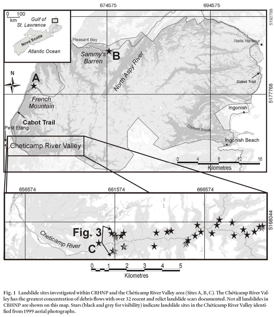
Display large image of Figure 1
7 Cape Breton Island is one of the more morphologically varied regions of Nova Scotia, and is characterised by flat-topped, steep-sided uplands, strongly undulating lowlands, and deep submarine channels and basins (Grant 1994). The highlands belong to the Atlantic Uplands physiographic region whereas the lowlands are a part of the Maritime Plain (Bostock 1970; Sanford and Grant 1976). The upland region is composed mainly of blocks of resistant crystalline rocks that have been uplifted to form the extensive plateau surface (Barr and Raeside 1989; Barr et al. 1992). Across Cape Breton Island, a folded shear zone between low- and high-grade units repeatedly intersects the present erosion surface indicating a low-angle tectonic boundary in which the high-grade rocks occur in structural domes (Keppie et al. 1998). The erosion of the predominantly weaker sedimentary rocks south of the highlands has left the northern plateau standing above the more subdued southern topography (Grant 1994).
8 The rocks in CBHNP are predominantly Late Precambrian to Middle Paleozoic and represent a complex series of terranes typical of the Appalachian orogen. Predominant rock types include granitic, dioritic, and tonalitic plutonic rocks, gneiss, meta-volcanic, meta-sedimentary, and Carboniferous sedimentary rocks. Northerly to north- easterly bedrock structural trends are defined by foliation, brittle faults, and ductile shears.
9 The CBH form part of a regionally extensive erosional surface, or peneplain, that dips gently to the southeast and is bounded by steep and rugged walls and rise to elevations of over 530 m (Finck 1993; Grant 1994). This upland pene-plain has a consistently smooth surface, with gentle gradients, smoothly rounded interfluves, very little exposed bedrock, and few of the undulations typically associated with glacially modified terrain (Grant 1994). Radiating outward from the centre of the domed peneplain is a well-developed network of deeply-incised, V-shaped valleys marking extensive fluvial erosion (Fig. 2).
Fig. 2 Photograph of the Chéticamp River Valley (looking west), showing the V-shaped valley profile and consistent slope angle that is common in the Cape Breton Highlands. Note the active talus slope on right (north) side of the photograph. Relief is approximately 270 m.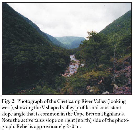
QUATERNARY GEOLOGY
10 The ice flow history of the CBH has been summarized by Grant (1994) and Stea et al. (1997). In the study area Late Wisconsinan ice flow was southeastward; however, flow patterns are thought to have reversed, flowing toward the northwest, north, and northeast from an ice centre located on the then-emergent continental shelf. Final ice flow was from local ice caps, one of which is believed be centred in the study region and may have persisted until as late as 8,000 ka (Grant 1994).
11 The U-shaped valleys typically associated with glacially modified landscapes are not common in the CBHNP. River valleys in the northern and western regions of the park are characterized by a well-developed dendritic drainage pattern consisting of deeply incised V-shaped river valleys. Occurrences of lodgement till and erratics are rare which, along with the occurrence of relict floral and faunal populations, led early researchers to conclude that significant portions of the CBH were nunataks during Late Wisconsinan time (Chalmers 1895; Fernald 1925; Coleman 1930 Lindroth 1963). However, glaciotectonic features and erratics to the south of the study area indicate that the region was ice covered (Finck 1992; Grant 1994). The preservation of grus and saprolite suggests that the glacial ice was locally non-erosive and therefore was frozen to its bed, cold-based, or stagnant (McKeague et al. 1983; Gosse et al. 2002; Marquette et al. 2004).
REGIONAL CLIMATE
12 The climate of Cape Breton Island is predominantly continental as it lies under the converging tracks of most east-moving storms of eastern North America (Environment Canada 2002; Grant 1994). Storms frequently pass close to the coast of Cape Breton Island, producing highly variable and typically stormy weather. The extreme temperature variations of eastward moving continental air are regulated by the ameliorating effect of the ocean producing cool, short summers, moderate but long winters, and significant amounts of precipitation. Precipitation varies with proximity to the coast and elevation, and ranges from 1600 mm/yr in highland areas to 1200 mm/yr along the Gulf of St. Lawrence coast (Grant 1994). Snowfall, typically 400 cm annually, is common from December until April and often persists into June in the highlands (Grant 1994).
VEGETATION
13 Much of the vegetation in the area is related to specific physiographic and climate conditions. On valley floors, lower slopes, and in ravines, white spruce and balsam fir dominate areas of till accumulation, whereas black spruce is associated with terraces and poor drainage and white pine with glacial gravel. Above 150 m in elevation, the upland sugar maple-yellow birch-fir zone dominates (Loucks 1962; Rowe 1972). On slopes and ridges, the coniferous species tend to be replaced by tolerant hardwood species, such as maple, beech, and birch. Between highland slopes of 250 m to 350 m elevation, coniferous species of the plateau fir-pine-birch zone begin to dominate the landscape. Above 400 m, balsam fir, white spruce, and black spruce are the most predominant species. Where fire has occurred in the past, jack pine tends to grow, such as on the eastern coast of the northern highlands. The summit area above 450 m is the taiga-spruce zone. This zone is dominated by heath-shrub barrens and stunted thickets of black spruce krummholz that have been deformed by wind stress, as the climate in these areas is too harsh for closed forest stands (Rowe 1972).
PREVIOUS RESEARCH
14 Previous documented and published research on landslides in the CBH is limited (Wahl 2003; Barker 2001; Grant 1994; Finck 1993, 1992). Finck (1993, 1992) examined mass wasting processes in the central Cape Breton Highlands and documented numerous coarse sediment flows. The study was carried out to establish a baseline so that changes in landslide distribution and frequency could be determined. As well, local factors that influence slope stability and initiate failures were investigated. Finck (1993) found that debris avalanches within stream valleys draining the highlands are a significant geologic hazard. His concern stemmed from an apparent increase in landslide activity observed within the area (Finck 1992). Failures were attributed primarily to loading of the mid-slope areas by rock fall or topple from the upper slope near the intersection between the peneplain and the valley wall. This increased mass, compounded by a plane of weakness between the more competent bedrock underlying less cohesive colluvium, led to slippage and slope failure. Finck (1993) suggested that the spruce budworm ( Choristoneura fumiferana Clem.) infestation of the late 1970's, as well as seasonal precipitation, may have influenced slope stability in the central CBH. Spruce budworm infestation was first recognised in Cape Breton Island in the early 1970's (MacLean and Ostaff 1989). This defoliation event caused extensive dieback in the balsam fir population, and was, therefore, considered influential on the overall slope stability.
15 The work of Grant (1994) described the Quaternary geology of Cape Breton Island, but did not include a comprehensive analysis of the specific landslide events in the region. Grant (1994) postulated that slope failures occurred as a result of mid- to late-spring snow avalanching or snowmelt, or possibly during rain-on-snow periods when the ground is saturated and partly snow-free. Based on his observations, Grant (1994) determined that "hydrology is clearly the operative process" in the slope failure activity in the CBHNP region.
16 Barker (2001) documented debris flows observed within the Chéticamp River Valley in an attempt to develop an environmental hazard prediction model using GIS technology. Although this preliminary model represented a basic representation of potential slope failure hazard within the study area, it indicated that debris flows are common, potentially hazardous sites abound, and that there exists the need for a comprehensive analysis of slope stability within the region.
17 Wahl (2003) investigated the morphology and potential influences on slope failure in the CBHNP as necessary to the development of an effective and site appropriate landslide risk assessment model. A Slope Assessment Model (SAM) was developed through the implementation in a GIS of the Infinite Slope Stability model, which enables the classification of relative slope stability in CBHNP (Hammond et al. 1992; Montgomery and Dietrich 1994; Pack et al. 1998). In this approach, the geotechnical properties of the surface material were used in combination with the forces acting upon the slope to calculate a factor of safety (FS), which is the ratio of stabilizing-to-destabilizing forces on a slope (Bishop 1955). GIS-based analysis through the Slope Assessment Model revealed areas of significant risk within the Cape Breton Highlands National Park. A total of 6 stability classes were identified, ranging from class 1 (chronically unstable) to class 6 (unconditionally stable). The resultant stability classification through the Slope Assessment Model was evaluated using aerial photographs on select sites. This evaluation indicated that the Slope Assessment Model was both precise and accurate in its classification of slope stability.
METHODS
18 A landslide inventory was generated using air photos (1:10 000 scale; 1999) and orthophoto maps (1:10 000 scale; 1979). Aerial photographs were provided by Acadia University and Parks Canada for several areas within the CBHNP, including the Chéticamp River, Clyburn Brook, and North Aspy River (Fig. 1). These river valleys were selected for investigation, as each one is interpreted as being representative of distinct regions within the CBHNP. In order to spatially locate the landslide scars identified, each aerial photograph was scanned and then digitally corrected and georeferenced. Once in digital form, and spatially georeferenced to the Universal Transverse Mercator (UTM) projection using the North American Datum of 1983 (NAD83) and landslide locations identified and positioned. A 5 m DEM was generated by the ArcGIS TOPOGRID command and was used to determine the relationship between topography and landslide occurrence. Spruce Budworm infestation was evaluated through image analysis of Landsat TM imagery generated by Allen (1994) and provided in-kind for this study.
19 Fieldwork was conducted in August of 2001. Sites previously identified from airphotos were located in the field and the causative factors influencing the event initiation, the resultant landslide morphology, and the physical and environmental conditions in which failure occurred were assessed.
20 Although examples of slope failure were identified within each river valley, field examination of failure sites was difficult. The dense forest canopy and abundant vegetation in the deeply incised river valleys prevented site investigation of many of the sites observed in the imagery. Detailed field investigations were carried out at French Mountain (Site A, Fig. 1) on the east side of the CBHNP and Sammys Barren (Site B, Fig. 1) in the north-central region of CBHNP. Thirty two debris flow scars were identified in the Chéticamp River Valley; one site (Site C, Fig. 1) was chosen for detailed examination due to ease of access.
RESULTS
Debris Flows: General Description
21 The debris flow scars identified in CBHNP are typically long, narrow, and relatively straight, initiating near the top of the valley wall where the slope gradient is generally the steepest (Fig. 3). Head scarps commonly occur just below the peneplain edge at elevations ranging from 260 m to 401 m, with an average of 340 m. The slopes where failures occur range from 27° to 48°, with an average gradient of 39°. They tend to be slopes where there is little to no association with large-scale surface depressions or gullies. Although these flow scars were observed as spanning the entire length of the slope to the valley floor, they can be shorter (< 150 m in length). The debris flow scars are relatively narrow (5 m to 20 m) and shallow, removing 0.5 m to 1.5 m of surface sediment; we call these failures thin-skinned debris flow. The remnant debris apron is primarily gravel to boulder sized, with the fine fraction most likely removed by consequent rainfall and snowmelt. This debris is consistently angular, unsorted and exhibits down-slope heterogeneity of clast size and composition. The presence of inverted trees of varying size, shattered rock, and scouring to bedrock indicate that failure is rapid and turbulent, and falls broadly within the classification scheme of debris flow (Varnes 1978).
Fig. 3 3D perspective of aerial photograph 99311-67, looking east. This photograph was draped over a 5 m DEM to generate a three-dimensional perspective of the V-shaped valley form typical in Cape Breton Highlands National Park. Failure occurred on open slopes rarely associated with large-scale gullies or surface depressions. Relief in this image is approximately 400 m (Note: no vertical exaggeration). Photo Source: Service Nova Scotia and Municipal Relations, Nova Scotia Geomatics Centre, 160 Willow Street, Amherst, NS.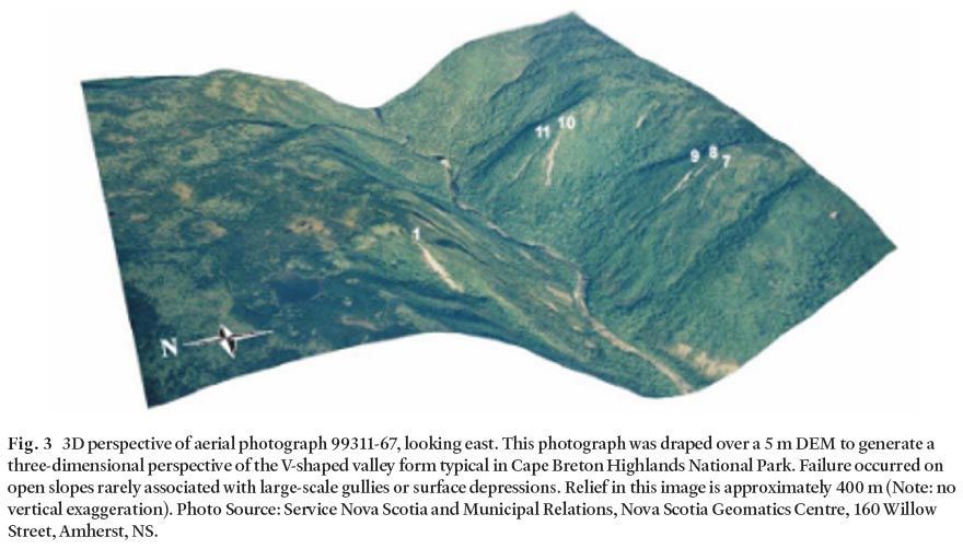
French Mountain (Site A, Fig. 1)
22 Site A (Figures 1, 4, 5, 6, 7) is located on the south-facing (217°) slope of Ruis Sauteu Brook, on the north side of French Mountain (661165E, 5179120N). This site, also accessible directly off the Cabot Trail, is a recent debris flow similar to other flows within the study area. Failure occurred at 374 m ASL on a 33° slope of granitoid gneiss (Barr et al. 1992). This flow, which extends the entire length of the slope, is long (125 m) and narrow (10 m wide at the initiation zone), and denuded approximately 1 m of material from the initiation zone (Fig. 4). Although the centre of the flow track appears to have stabilized, as evident from the re-growth of white birch ( Betula papyrifera), the sides of the track have remained unstable or recently been remobilized on a small scale. A mass of debris including boulders, rock fragments, fine-to coarse-grained sediment, inverted trees, and other vegetation had accumulated at the base of the slope and altered the natural hydraulics of the brook (Fig. 5). This change is evident from an accumulation of fine- to medium-grained sediment upstream of the obstruction not seen elsewhere in the brook. Examination of the initiation zone at this site revealed a thin layer of over-compacted, matrix-supported, non-porous glacial sediment smeared as a thin veneer, perhaps only 10–20 cm thick, underlying the colluvium (Fig. 6). The contact between the impermeable lodgement till and the highly permeable surface colluvium could act as a barrier to water infiltration and thus provide a conduit for groundwater transport with very low perceived friction. This conduit would force groundwater flow along the surface of the till barrier, thereby decreasing shear strength and creating a favourable location for the initiation of slip.
Fig. 4 Debris flow on a south-facing slope of French Mountain (see Fig. 1, Site A). This debris flow is long and narrow, was initiated just below the peneplain-valley wall intersection, and ran the entire length of the slope.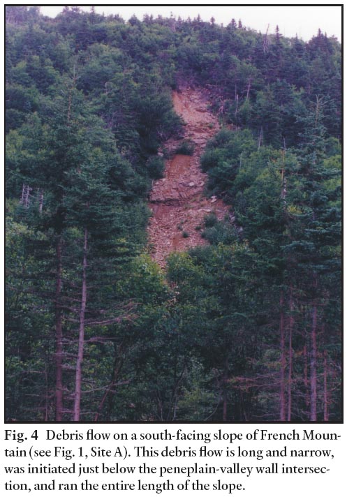
Display large image of Figure 4
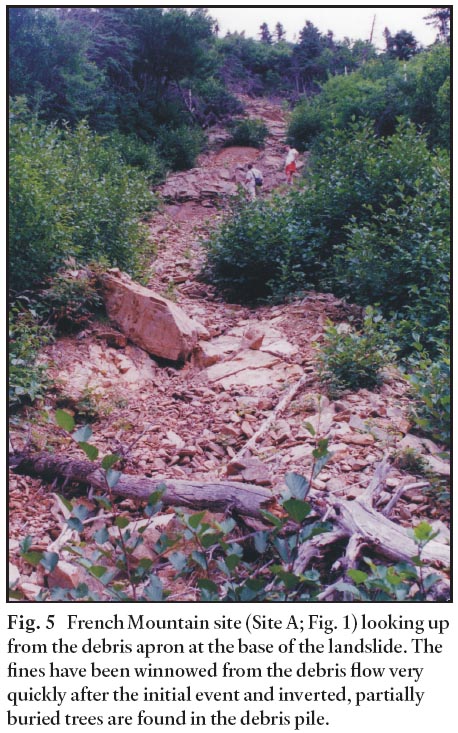
Display large image of Figure 5
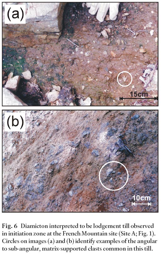
Display large image of Figure 6
Display large image of Figure 7
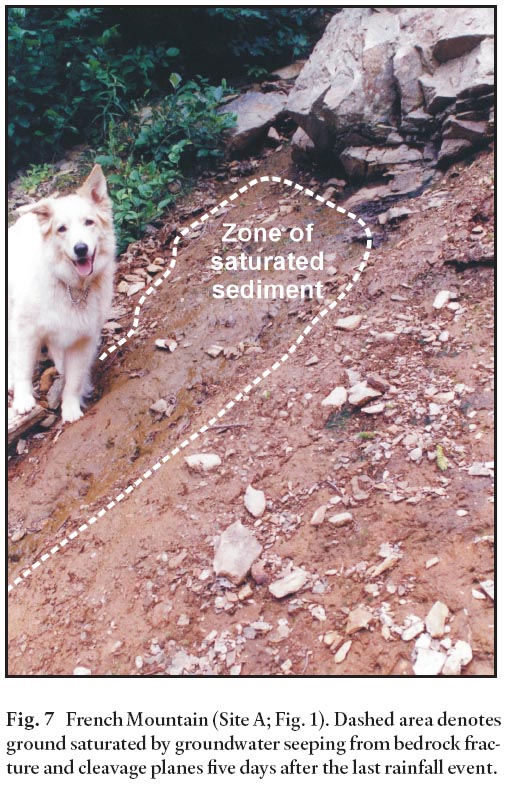
23 Also observed in the initiation zone of the French Mountain site was an outcrop of highly cleaved semi-pelitic gneiss. Although the summer of 2001 was a relatively hot and dry period (G. Morin, Environment Canada, personal communication, 2002), a steady flow of groundwater seeped from cleavage and fracture planes of exposed bedrock onto the adjacent layer of lodgement till (Fig. 7).
Sammys Barren (Site B)
24 Site B (Figure 1, 8) is located on the southwest-facing (249°) slope of Sammys Barren, accessible directly off the Cabot Trail (674998E, 5186148N) in the north-central region of the CBHNP. The slide scar is recent and is approximately 100 m long and 12 m wide in the zone of initiation. About 1200 m3 of sediment was removed from the site. The lack of any vegetation along the failure track indicates recent instability. The initiation zone occurs near the top of the valley wall just below the peneplain boundary at an elevation of 341 m ASL. The slopes adjacent to this failure site are heavily forested and host a variety of species including black spruce ( Picea mariana), white birch ( Betula papyrifera), balsam fir ( Abies balsamea), and sugar maple ( Acer saccharam) amidst dense understory vegetation. Unlike most of the inventoried landslides in the Chéticamp River Valley, this debris flow failed on a slope composed primarily of schist (Barr et al. 1992) with a slope of 35°.
Fig. 8 Stratigraphy at head scarp of Sammys Barren site (Site B; Fig. 1). Weathered bedrock with grus grades upward into saprolite and is overlain by till and colluvium. Small rivulets are evident on the left side of the image due to seepage from cleavage planes and cracks in the weathered bedrock.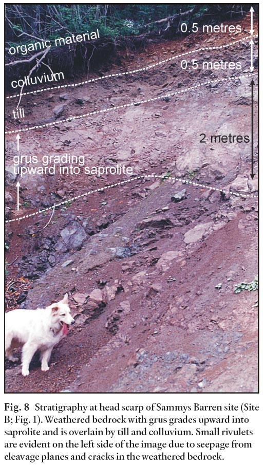
Display large image of Figure 8
25 In the initiation zone at Site B, complex stratigraphy was exposed (Fig. 8). Several hydrostratigraphic units appear within the overlying soil mantle, and from the surface to the underlying bedrock are: (1) a 15 cm humic layer, (2) a 50 cm-thick unsorted mixture of loose, heterogeneous, fine to coarse-grained colluvium and organic material supported primarily by angular to subangular clasts averaging 5–15 cm in diameter; (3) a 50 cm-thick unsorted mixture of fine- to medium-grained colluvium with a more sandy consistency and fewer angular to sub-angular clasts than (2), up to 10 cm in diameter; and (4) a highly compacted fine to very fine grained 0.5 m thick diamicton layer with small (< 5 cm in diameter) subangular clasts. The difference in permeability between the colluvium and till was apparent in the exposed headscarp. Here, water was observed to penetrating the porous colluvium; however, the contact with the till unit appeared to act as a plane for concentrated groundwater flow. Environment Canada climate records indicate a total of 28.4 mm of rain in the month leading up to field investigations, with no rain falling in the 5 days prior to site investigations (G. Morin, Environment Canada, personal communication, 2002). Despite a lack of rainfall during the field investigation, water seeped from this contact on the face of the headscarp (Fig. 8).
Chéticamp River Valley (Site C, Fig. 1)
26 Thirty-two sites in the Chéticamp River Valley were identified from aerial photograph interpretation and most were observed from a distance as densely forested slopes restricted access by foot. Ninety-four percent of the landslides were found to have occurred on slopes consisting primarily of granite or quartzofeldspathic orthogneiss overlain by a thin mantle of colluvium. The granitic rocks are more competent than the sedimentary and metamorphic rocks in the study area due to low primary porosity and limited fracturing or cleavage. Valley walls composed of granite tend to be over-steepened, and therefore may be more susceptible to failure (Finck 1993). Slopes in the Chéticamp River Valley averaged 39°.
27 A recent debris flow scar was observed at Site C (Fig. 1) that was representative of other debris flows in the CBHNP in its long (85 m) and narrow (15 m) form. Approximately 1900 m3 of colluviated sediment was removed from this site. The debris apron was very coarse as the fine fraction had been winnowed away by rainfall and snowmelt. Despite the re-growth of white birch ( Betula papyrifera) in the centre of the track, this site appeared to have been reactivated after initial failure, as indicated by the remobilization of sediment in small water-fed rivulets (Fig. 9).
Fig. 9 Remobilization of fine- to medium-grained material at Site C, Chéticamp River Valley (Fig. 1). This photograph shows the toe of a debris flow from which all fine-grained sediment has been winnowed away by rainfall and snowmelt. The central area of finer grained material represents recently reactivated, newly colluviated sediment transported down slope by surface water runoff.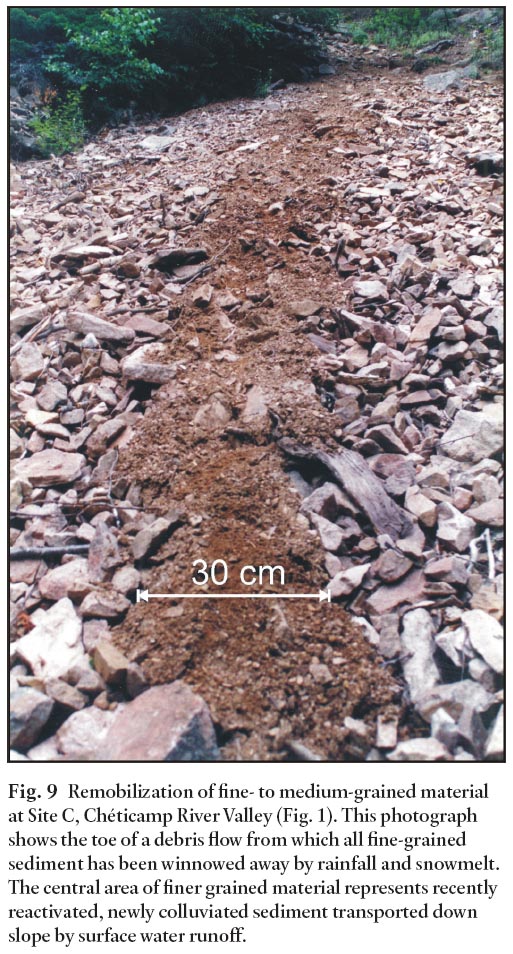
Observations made from imagery
28 Slope configuration, or curvature, is derived from the second derivative of the elevation, and is classified as rectilinear, concave, or convex (Gao and Lo 1995). Though debris flows in the CBHNP were observed on slopes not associated with gullies or large-scale depressions, the local slope geometry was assumed to have some influence on the overall slope stability. Concavity is expressed by negative values, convexity by positive values, and flat areas by a value approaching 0. Of the 35 landslides observed, the average profile curvature was -0.3, with a minimum value of -1.6 and a maximum of 0.8. Planform curvatures averaged 0.1, with minimum and maximum observed values of -1.7 and 2.3, respectively.
29 An outbreak of spruce budworm was recognised in the CBHNP in 1974 (MacLean and Ostaff 1989) and mapped by Allen (1994). The distribution of damaged tree stands in the CBHNP revealed that dieback occurred predominantly on the peneplain surface; however, the upper slope regions of many of the valley walls also appeared to have been infested. Quantification of the degree to which the defoliation event affected slope stability was difficult, as data quality is coarse (the spruce budworm damage dataset was constructed using 25 m Landsat-5 imagery) and defoliation was probably not the limiting factor in failure. Band composites 3, 7, NDVI and 2, 5, 3 of Landsat-5 satellite imagery revealed a strong relationship between peneplain saturation and slope stability. Each composite image contained regions that appeared to be saturated with slope failure often occurring on the slopes below.
DISCUSSION
30 Kochel (1987) noted that "considerable discrepancy exists in the terminology of rapid mass movements involving poorly sorted mixtures of clastic debris, organic debris and water". The debris flows identified in this study are similar to intermediate mobility avalanches described by Finck (1992, 1993). Finck (1993) used terminology developed by Nicoletti and Sorriso-Valvo (1991) that describes "ribbon shaped avalanches where the detachment zone is approximately amphitheatre shaped and there is a narrow valley down which debris is channelized". In this paper we employ an alternative nomenclature "thin-skinned debris flows" (TSDF) to avoid confusion with the term catastrophic rock avalanches, also known as sturzstroms. Sturzstroms can move along a flat course for unexpectedly large distances and may surge upward by the power of their momentum (Pierson and Costa 1987). A currently popular hypothesis to account for their excessive distance of transport suggests that sturzstroms slide on air cushions (Hsü 1975; Mitchell et al. 2001); we saw no evidence of this activity in CBHNP. However, the presence of step-like features and some residual trees just below the detachment zone at many of the landslide sites in CBHNP indicate that they may have initiated as rotational slumps or avalanches.
31 Similar to the avalanches described by Finck (1993), the TSDF in the CBHNP consistently failed metres below the peneplain-valley wall intersection. The combination of soft-wood stand dieback on the upper valley slopes and peneplain surface saturation in CBHNP may enhance slope instability. The avalanches of the Margaree River Valley study area are unrestricted by slope morphology and typically crossed the upper, middle, and lower slopes of the valley walls, often stopping only upon reaching the valley floor (Finck 1993). These events often resulted in partial damming of the river. Though several landslides in the CBHNP also reached the valley floor and caused minor obstruction to the stream below, most terminated upslope.
32 The TSDF observed in this study have other unique attributes. In many cases they initiated at the contact between lodgement till or bedrock and the overlying colluvium or saprolite/grus layer, respectively; failure at the base of the saprolite/grus was rare in the Margaree Valley study (Finck 1993). These subtle but significant differences in landslide process may be attributed to the style of glaciation of the region; specifically the presence or absence or cold-based ice at a particular study site. Under cold-based ice, subglacial erosion can be limited, V-shaped valleys are possible and pre-glacial deposits can be preserved (Davis et al. 2006; Marquette et al. 2004). Cold-based conditions may have been particularly prevalent in the Chéticamp River Valley where the vast majority of TSDF in CBHNP occur.
33 The presence of colluvium is effectively a requirement for TSDF in CBHNP, a low frequency of debris flows was observed in areas where outcrop was evident. This is not to say that these particular areas are immune to failure, rather they are more likely to fail by rockfall or topple, and not flow. Field observation and a cursory examination of the Chéticamp River Valley would likely lead to the supposition that almost all slopes would be susceptible to failure as colluvium cover is pervasive (Stea et al. 1997). The valley walls have remarkably consistent slope gradients (likely a consequence of cold-based ice) and no obvious relationship is apparent between slope morphology and failure. Most debris flow studies indicate that instability is elevated in areas of convergent topography where saturation is assumed to occur more readily (Kochel 1987; Sidle and Masahiro 2004). Although this assumption may be valid for some regions, the TSDF in the CBHNP are not associated with large-scale gully features, depressions, or obvious topographic convergence. Rather, they are consistently identified on open slopes. Additionally, colluvium is consistently 1.5 m thick. This colluvium was also observed as having very high relative permeability, with the underlying substrate exhibiting permeability most likely several orders of magnitude lower. Therefore, it is also reasonable to assume that shallow lateral flow in the sub-surface follows the topographic gradients as expressed by the slope morphology. Detailed analyses of the DEM indicated that slope failure occurs primarily on open or slightly convex slopes. Instability is pronounced where the transition from peneplain to valley slope is rapid. Where this transition is more gradual, significant instability was not noted.
34 Finck (1993) and Grant (1994) recognized that most of the valley walls in the CBH exhibit evidence of creep. In the Chéticamp River Valley most slopes are populated by trees of variable age, almost all of which have trunks curved at their bases. This curvature is convincing evidence that creep is currently active in this region as well. It is, therefore, plausible that constant modification of slope morphometry and composition is occurring; in effect, slopes that failed in the past may quickly become replenished with highly porous colluvium, an effective conduit for surface water to the glide plane. This development may lead to increased instability and consequent failure in the future; climate also may play a dominant role in recurrence (Wahl 2003). As well, Grant (1994) noted that rockfall and topple are relatively common in the study area and noted "innumerable" occurrences along the peneplain edges. Rockfalls may also serve as an effective means by which relict debris flow scars are replenished.
CONCLUSIONS
35 In CBHNP thin-skinned debris flows are complex failure events that begin as thin translational slides or rotational slumps that rapidly evolve into debris flows. They are characteristically ribbon-shaped in plan view, initiate at or near the top of the valley wall just below the intersection with the pene-plain, and in places run the entire length of the slope. Failure occurs on slopes ranging from 27° to 48°, involving no more than the surface 1.5 m of material. Slopes on which failure occurred are commonly open, with no observed association with surface depressions or gullies.
36 Site investigations revealed two hydrostratigraphic relationships: 1) highly compacted, impermeable clay-rich lodgement till is commonly overlain by highly permeable colluvium, and 2) impermeable weathered bedrock in the form of saprolite is commonly overlain by permeable colluvium. The unit boundaries act as both a barrier to throughflow and a conduit for groundwater flow. Infiltrating surface and ground water accumulated at this impermeable interface within the activation zone, which produced an effective glide plane for initial translational movement.
37 Detailed investigation of selected sites is required to further constrain the physical parameters involved in slope failure. Loss of root cohesion and locally saturated conditions on the peneplain may combine to enhance the probability of failure. An understanding of trigger mechanisms is poorly developed, a problem common to many landslide assessments. As Finck (1993) has demonstrated, a comprehensive time-series analysis for all available aerial photographs would also better constrain the environmental and climatic influences on slope stability.
ACKNOWLEDGEMENTS
The research was funded by Natural Sciences and Engineering Research Council (I. Spooner), the Applied Geomatics Research Group (K. Wahl and D. Colville), and an Acadia University Research Grant. The authors would like to thank Bob Maher and Tim Webster (Applied Geomatics Research Group) for guidance and thoughtful comments. James Bridgeland, Ecologist at the Cape Breton Highlands National Park, graciously provided advice, data, and access to the park. An essential component of this study was the incorporation of aerial photography and vegetation data, kindly provided by Dawn Allen of Atlantic Service Centre – Parks Canada Agency. The manuscript was improved by the suggestions of reviewers T. Pronk and B. Broster. We also thank Don Fox for handling the editorial process for this paper.REFERENCES
Allen, D. 1994. Assessment of the utility of Landsat TM data for updating vegetation mapping. Unpublished manuscript, College of Geographic Sciences, Lawrencetown, Nova Scotia, 94 p.
Barker, M. 2001. The characterization of debris flow landslides and the development of a geographic information system environmental hazards prediction model for Cheticamp River valley, Cape Breton, Nova Scotia. Unpublished B.Sc. Thesis, Acadia University, Wolfville, Nova Scotia, 73 p.
Barr, S. M., and Raeside, R. P. 1989. Tectono-stratigraphic terranes in Cape Breton Island, Nova Scotia: Implications for the configuration of terranes in the northern Appalachian Orogen. Geology, 17, pp. 822–825.
Barr, S.M., Jamieson, R.A., and Raeside, R.P. 1992. Geology, Northern Cape Breton Island, Nova Scotia. Geological Survey of Canada, Map 1752A, scale 1:100,000.
Bishop, A.W. 1955. The use of the slip circle in the stability analysis of earth slopes. Géotechnique, 5, pp. 7–17.
Bostock, H.S. 1970. Physiographic regions of Canada. Geological Survey of Canada, Map1254A, scale 1:5,000,000.
Chalmers, R. 1895. Surface geology, part of eastern New Brunswick and Prince Edward Island, Cape Traverse sheet. Geological Survey of Canada, Multicoloured Geological Map 563, scale 1:253,440.
Coleman, A.P. 1930. The extent of Wisconsin glaciation. American Journal of Sciences, 20, pp. 180–183.
Davis, P.T., Briner, J.P., Coulthard, R.D., Finkel, R.W., and Miller, G.H. 2006. Preservation of Arctic Landscapes overridden by cold-based ice sheets. Quaternary Research, 65, pp. 156–163.
Dikau, R., Cavallin, A., and Jäger, S. 1996. Databases and GIS for landslide research in Europe. Geomorphology, 15, pp. 227–239.
Environment Canada. 2002. The Climate of Nova Scotia. URL <http://www.atl.ec.gc.ca/climate/ns.html>, January 2003.
Fernald, M.L. 1925. Persistence of plants in unglaciated areas of boreal America. American Academy of Arts and Sciences, Memoir 15, pp. 239–342.
Finck, P.W. 1992. Surficial and Environmental Geology of the Western Cape Breton Highlands, Nova Scotia. Mines and Energy Branches, Paper 92-1, 21 p.
Finck, P.W. 1993. An evaluation of debris avalanches in the Central Cape Breton Highlands, Nova Scotia. Mines and Energy Branches, Paper 93-1, 65 p.
Gao, J., and Lo, C.P. 1995. Micro-scale modelling of terrain susceptibility to landsliding from a DEM: a GIS approach. Geocarto International, 10, pp. 15–30.
Gosse, J., Gray, J., and Grant, D. 2002. Uses of in situ cosmogenic nuclides for supporting geomorphology and ice cover simulations for Atlantic Canada. Atlantic Canada Glacier Ice Dynamics Workshop, May 22–24, 2002, Dalhousie University, Halifax, Nova Scotia.
Grant, D. R. 1994. Quaternary Geology, Cape Breton Island, Nova Scotia. Geological Survey of Canada Bulletin 482, 159 p.
Hammond, C., Hall, D., Miller, S., and Swetik, P. 1992. Level I Stability Analysis (LISA) Documentation for version 2.0. General Technical Report INT-285, USDA Forest Service Intermountain Research Station, 190 p..
Hsü, K.J. 1975. Catastrophic Debris Streams (Sturzstroms) Generated by Rockfalls. Geological Society of America Bulletin, 86, pp. 129–140.
Keppie, J.D., Davis, D.W., and Krogh, T.E. 1998. U-Pb geo-chronological constraints on Precambrian stratified units in the Avalon Composite Terrane of Nova Scotia, Canada: tectonic implications. Canadian Journal of Earth Sciences, 35, pp. 222–236.
Kochel, C.R. 1987. Holocene Debris Flows in central Virginia. Geological Society of America Reviews in Engineering Geology, 7, pp. 139–156.
Lindroth, C.H. 1963. The faunal history of Newfoundland illustrated by carabid beetles. Opuscula entomologica, supplementum, 23, 112 p.
Loucks, O.L. 1962. A forest classification for the Maritime Provinces. Proceedings of the Nova Scotian Institute of Science, 25, pp. 85–167.
Marquette, G.C., Gray, J.T., Gosse, J.C., Courchesne, F., Stockl, L., Macpherson, G., and Finkel, R. 2004. Felsenmeer persistence under non-erosive ice in the torngat and Kaumajet Mountains, Quebec and Labrador, as determined by soil weathering and cosmogenic nuclide exposure dating. Canadian Journal of Earth Sciences, 41, pp. 19–38.
McKeague, J.A., Grant, D.R., Kodama, H., Beke, G.J., and Wang, C. 1983. Properties and genesis of a soil and the underlying gibbsite-bearing saprolite, Cape Breton Island, Canadian Journal of Earth Sciences, 20, pp. 37–48.
MacLean, D.A., and Ostaff, D.P. 1989. Patterns of mortality caused by an uncontrolled spruce budworm outbreak on Cape Breton Island, Nova Scotia. Canadian Journal of Forestry Research, 19, pp. 1087–1095.
Mitchell, W. A. <mailto:w.mitchell@luton.ac.uk> , Dunning, G, S., Taylor, P. J., McSaveney, M. J., and Strom, A. 2001. Investigation of rock avalanches in High Mountains. Earth System Processes – Global Meeting (June 24–28, 2001) Edinburgh, Great Britain, Abstract G7.
Montgomery, D.R., and Dietrich, W.E. 1994. A physically based model for topographic control on shallow landsliding. Water Resources Research, 30, pp. 1153-1171.
Nicoletti, P.G., and Sorriso-Valvo, M. 1991. Geomorphic controls of the shape and mobility of rock avalanches. Geological Society of America Bulletin, 103, pp. 1365–1373.
Pack, R.T., Tarboton, D.G., and Goodwin, C.N.O. 1998. Terrain stability mapping with SINMAP, technical description and users guide for version 1.00. Terratech Consulting Ltd., Report Number 4114-0 , Salmon Arm, British Columbia, Canada, 65 p.
Pierson, T.C., and Costa, J.E. 1987. A rheologic classification of subaerial sediment-water flows. In Debris flows/ avalanches: process, recognition and mitigation. Edited by J.E. Costa and G.F. Wieczorek, Geological Society of America Reviews in Engineering Geology, 7, pp. 1–12.
Rowe, J.S. 1972. Forest regions of Canada. Canada Department of Fisheries and the Environment , Canadian Forestry Service, Publication 1300, 172 p.
Sanford, B., and Grant, G. M. 1976. Physiography, Eastern Canada and adjacent areas. Geological Survey of Canada, Map1399A (4 sheets), scale 1:2,500,000.
Schuster, R.L., and Highland, L.M. 2001. Socioeconomic and Environmental Impacts of Landslides in the Western Hemisphere. United States Geological Survey, Open-File Report 01-0276, 48 p.
Sidle, R.C., and Masahiro, C. 2004. Landslides and Debris Flows Strike Kyushu, Japan. EOS, 85, pp. 145–151.
Stea, R.R., Conley, H., and Brown, Y. 1997. Surficial Geology Map of the Province of Nova Scotia, compiled 1992, version 1, Map 92-03, scale 1:500 000, URL <<http://www.gov.ns.ca/natr/meb/pubs/pubs3.htm#maps>>, April 2002.
Varnes, D.J. 1978. Slope movement types and processes, In Landslides: Analysis and Control, Transport Research Board, National Academy of Sciences Special Report, Washington, D.C., pp. 11–33.
Varnes, D.J. 1984. Landslide hazard zonation: a review of principles and practice. International Association of Engineering Geology, Commission on Landslides and Other Mass-Movements, 48 p.
Wahl. K.A. 2003. An Assessment of Landslide Potential in Cape Breton Highlands National Park: A GIS Approach. Unpublished M.Sc. Thesis, Acadia University, Wolfville, Nova Scotia, 252 p.
Editorial responsibility: Sandra M. Barr