Article
Deformation of soft sediments and evaporites in a tectonically active basin:
Bay St. George sub-basin, Newfoundland, Canada
doi:10.4138/atlgeol.2021.013
Abstract
The Bay St. George sub-basin of SW Newfoundland, part of the larger late Paleozoic Maritimes basin, formed under the influence of strike-slip faulting and the movement of evaporites. New stratigraphic correlations between Newfoundland and other late Paleozoic sub-basins illustrate the effects of both basement and salt movement. Coastal outcrops show complex combinations of synsedimentary, salt-related, and tectonic structures. Map relationships and dramatic thickness contrasts in the Tournaisian Anguille Group indicate that a large, concealed, NE–striking normal growth fault (Ship Cove fault) controlled sedimentation; the exposed Snakes Bight fault originated as a hanging-wall splay. Structures formed during, or soon after deposition include soft-sediment folds, boudins, clastic dykes, and millimetre-scale diapiric bulb structures, formed by overpressuring and liquidization of sediment. These suggest that the sub-basin was tectonically active throughout deposition. Evaporite-related deformation is recorded in the Visean Codroy Group and overlying strata. Comparisons between outcrop and subsurface suggests that significant amounts of evaporite were removed from exposed sections by halokinesis and solution. Complex outcrop relationships indicate salt welds, and suggest that units of the upper Codroy and overlying Barachois groups represent fills of minibasins that subsided into thick evaporites. Field relationships suggest tectonic inversion deposition related to E-W dextral strike slip motion that affected the entire Maritimes basin in the Serpukhovian, producing reverse-sense offsets and contractional folds. Many of the structures in the Bay St. George sub-basin, previously interpreted as post-depositional and purely tectonic, were formed by deformation of unlithified sediment and ductile evaporites during basin development.
Résumé
Le sous-bassin de la baie St-George dans le sud-ouest de Terre-Neuve, qui fait partie du bassin plus vaste du Paléozoïque tardif des Maritimes, s’est formé sous l’influence d’un coulissage et du déplacement d’évaporites. De nouvelles corrélations stratigraphiques entre Terre-Neuve et d’autres sous-bassins du Paléozoïque tardif illustrent les effets du déplacement du socle et de sel. Les affleurements côtiers présentent des combinaisons complexes de structures synsédimentaires, salifères et tectoniques. Les relations cartographiques et les contrastes spectaculaires de l’épaisseur au sein du groupe tournaisien d’Anguille révèlent qu’une vaste faille intraformationnelle normale, masquée, en direction nord-est (faille de l’Anse Ship) a contrôlé la sédimentation, et la faille découverte de la baie Snakes est provenue d’un point de divergence d’un toit. Les structures s’étant formées durant ou peu après le dépôt comprennent des plis de sédiments meubles, des boudins, des filons clastiques et des structures bulbiformes diapiriques à l’échelle millimétrique, créés par surpression et liquéfaction de sédiments. Cela laisse supposer que le sous-bassin a été tectoniquement actif tout au long de la sédimentation. La déformation liée aux évaporites est enregistrée dans le groupe viséen de Codroy et les strates sus-jacentes. Des comparaisons entre l’affleurement et le sous-sol permettent d’avancer que des quantités importantes d’évaporites ont été retranchées des sections exposées par halocinèse et solution. Les relations complexes des affleurements signalent des lithifications des sels et laissent supposer que les unités de la partie supérieure du groupe de Godroy et du groupe sus-jacent de Barachois représentent des comblements de mini-bassins s’étant transformés en évaporites épaisses. Les relations sur le terrain permettent d’évoquer une sédimentation par inversion tectonique liée à un mouvement de coulissage dextre d’est en ouest ayant touché l’ensemble du bassin des Maritimes au cours du Serpukhovien, qui a produit des plis de contraction et des décalages en sens inverse. Nombre des structures du sous-bassin de la baie St-George, précédemment interprétées comme des phénomènes ultérieurs à une sédimentation et purement tectoniques, ont été créées par une déformation des sédiments meubles et d’évaporites ductiles durant l’établissement du bassin.
[Traduit par la redaction]
INTRODUCTION
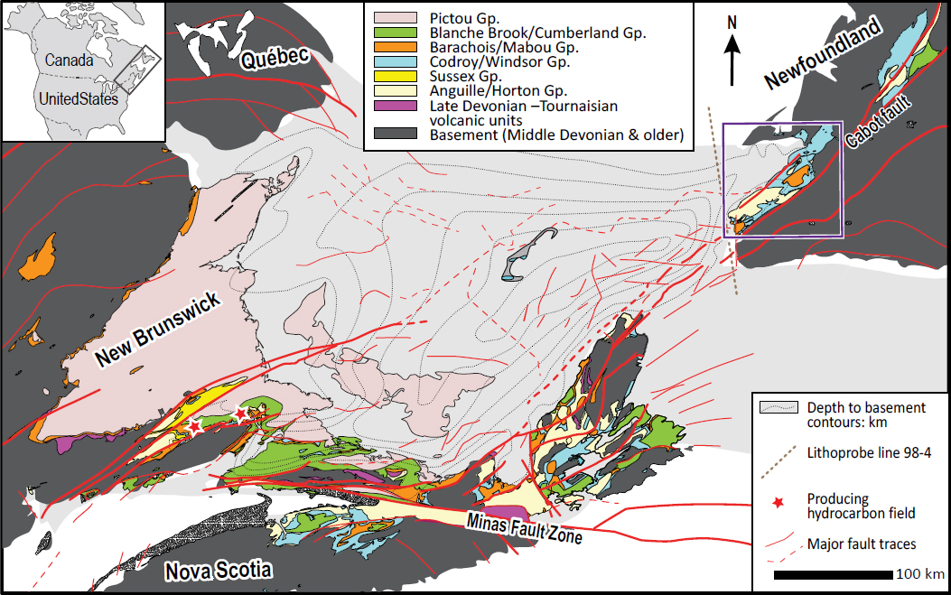
1 The Maritimes basin (Fig. 1) is a large and deep (>12 km) basin covering a large portion of onshore and offshore Atlantic Canada with late Paleozoic strata (Roliff 1962; Keppie 1982; Gibling et al. 2008, 2019). This basin formed during a period of transtension following the Acadian Orogeny (Calder 1998; Hibbard and Waldron 2009; Waldron et al.2015), and is structurally complex, displaying a mixture of extensional, contractional, strike-slip, and salt-tectonic features, which divide the basin into multiple NE and E-trending sub-basins separated by uplifted basement horsts (Boehner and Giles 1993; van de Poll et al. 1995; Gibling et al. 2008; Murphy et al. 2011; Gibling et al. 2019).
 Display large image of Figure 1
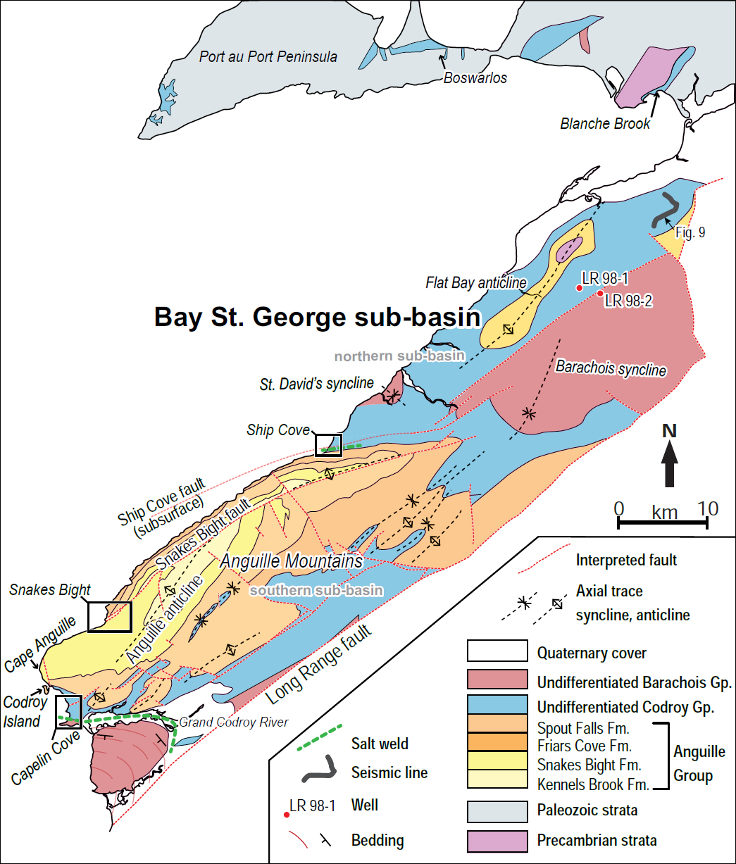
2 Within the larger Maritimes basin, the Bay St. George sub-basin (BSGSB) of SW Newfoundland and the adjacent Gulf of St Lawrence (Fig. 2) rests unconformably on Precambrian and early Paleozoic rocks of the Humber Zone of the Appalachian orogen. It contains deformed Carboniferous strata with significant resource potential, both on land (Knight 1983) and offshore (Dafoe et al. 2016). However, much of the on-land stratigraphy and structure (Knight 1983) was interpreted before recent advances in the study of evaporite movement, known as “salt tectonics” (e.g., Jackson and Hudec 2017), that have demonstrated close relationships with depositional histories in overlying strata. Parallel advances in understanding of soft-sedimentation (e.g., Obermeier 2009; Owen and Moretti 2011; Alfaro et al. 2016), have shown that earthquake-generated soft-sediment deformation features are common in tectonically active basins, occurring at many scales. Distinguishing between synsedimentary structures and post-deformation tectonic features within orogens may be challenging, but criteria have been developed (e.g., Waldron and Gagnon 2011; Alsop et al. 2019) to distinguish these processes. Studies in other parts of the Maritimes basin (e.g., Waldron and Rygel 2005; Waldron et al. 2013; Dafoe et al. 2016; Snyder and Waldron 2016) have shown that both soft-sediment deformation and evaporite expulsion into diapiric walls have had major impacts on basin structure.
 Display large image of Figure 2
3 In this paper we examine the structural history of the BSGSB, using detailed field mapping of outcrops previously interpreted as displaying tectonic folds and faults. A new stratigraphic correlation chart (Fig. 3) is introduced that better relates the BSGSB to other late Paleozoic sub-basins across Atlantic Canada and illustrates the effects of both basement tectonics and evaporite movement on the stratigraphy. Synsedimentary features, including soft-sediment deformation and salt-expulsion structures, are here documented in detail. Brittle structures that cut across these ductile structures are also here described at key locations. Our results show that soft-sediment deformation and salt expulsion occurred concurrently with faulting and tectonic inversion during the evolution of the sub-basin, providing a new perspective on the evolution of the sub-basin and its role in the Maritimes basin as a whole.
 Display large image of Figure 3
METHODS
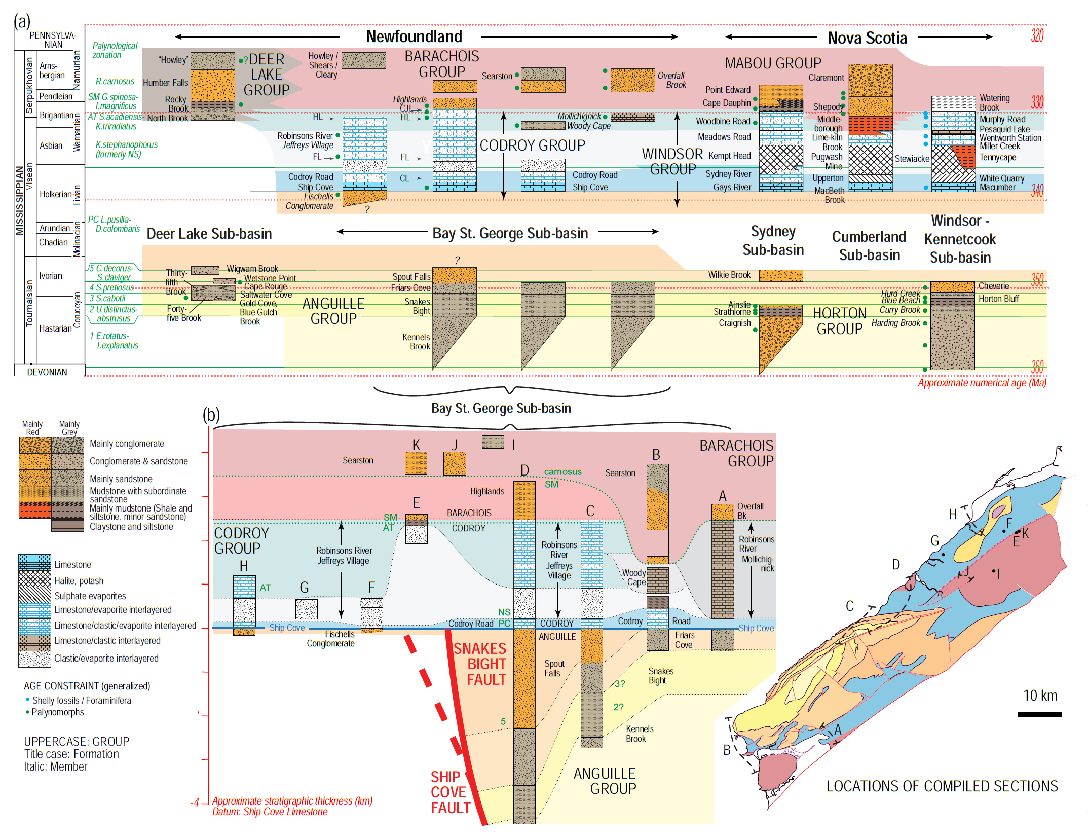
4 The most recent integrated stratigraphic and structural study in the on-land Bay St. George sub-basin was carried out by Knight (1983) who established the stratigraphic framework, using detailed measured coastal and river sections in less deformed parts of the sub-basin to determine thicknesses and establish a lithostratigraphic nomenclature. Knight (1983) suggested tentative correlations between laterally equivalent successions, although detailed biostratigraphic work by von Bitter and Plint-Geberl (1982) and Utting and Giles (2004, 2008) has modified some of these correlations. In addition, five on land 2-D seismic surveys were completed by Vulcan Minerals in the 1980s to aid in the exploration for salt and gypsum in the Flat Bay anticline area. We have acquired and reinterpreted SEG-Y data from these surveys using Schlumberger’s Petrel software. We have also compiled borehole information from the same area, including newer borehole results that have revealed additional thicknesses of evaporites not represented in the compilation of Knight (1983).
5 We review these integrated sources of stratigraphic information, combining them into a new stratigraphic chart (Fig. 3) that shows both lithostratigraphic and biostratigraphic correlations calibrated against a modern numerical time scale (Davydov et al. 2012; Waldron et al. 2017; Aretz et al. 2020). On the basis of this chart, we suggest revisions to the definitions of the Codroy and Barachois groups, bringing the group-level stratigraphic subdivisions into line with those in the rest of the Maritimes basin.
6 Our interpretation of the structural history is based on remapping and reinterpreting selected well-exposed coastal sections, building upon the regional framework provided by Knight (1983). We remapped key coastal outcrops at Ship Cove, Capelin Cove, and Snakes Bight (Fig. 2); we prepared detailed field maps at 1:10 000 scale to portray previously undescribed tectonic and evaporite-related structures. Orientations of structures including bedding, cleavage, fold hinges, faults, and soft-sediment structures were measured and uploaded into the geographic information system Arc-GIS. Key outcrops displaying soft-sediment deformation and salt structures were documented photographically. Fold axes were determined using stereographic projections plotted by Orient software (Vollmer 1995). Stratigraphic columns, maps, and cross-sections were constructed by projecting observations parallel to fold axes in areas of detailed mapping.
7 Knight (1983) identified examples of synsedimentary deformation and salt tectonism in the BSGSB. For example, he noted the presence of soft-sediment folds at Cape Anguille and Codroy Island (Fig. 2) but interpreted them as having played relatively minor roles in the overall development of the sub-basin. Significant advances in the study of soft- sediment deformation and salt tectonics have taken place since then. For example, Waldron and Gagnon (2011) suggested criteria for distinguishing soft-sediment deformation in deformed rocks of orogens, where overprinting by tectonic structures is common. Moretti et al. (2016) compiled recent studies of soft-sediment deformation, including a study (Snyder and Waldron 2016) of soft-sediment deformation in closely related Tournaisian strata of Nova Scotia. In this paper, we apply these insights to onshore portions of the BSGSB, where detailed observations of coastal outcrops are possible.
8 In salt tectonics, early studies (e.g., Ramberg 1981) interpreted deformation as ductile in both evaporites and the overlying strata. Vendeville and Jackson (1992a, b), showed that strata overlying evaporites have typically been deformed in the brittle domain, and that variations in their thickness represent differential sedimentation, not strain, on top of flowing evaporites (e.g., Hudec and Jackson 2011; Jackson and Hudec 2017). Once salt becomes mobilized, it collects into salt-cored anticlines and diapirs (Jackson and Talbot 1991; Jackson and Vendeville 1994; Ge et al. 1997; Hudec and Jackson 2004, 2007; Jackson and Hudec 2017). Intervening areas, known as minibasins, undergo subsidence, in many cases showing dramatic variations of sediment thickness over short distances (Hudec et al. 2009; Ings and Beaumont 2010; Garcia et al. 2012; Callot et al. 2016). The boundaries between minibasins and diapirs are marked by complex zones of multiple sheared unconformities (Giles and Lawton 1999; Rowan et al. 2012). These concepts were applied by Waldron and Rygel (2005) and Waldron et al. (2013) to the evolution of the Cumberland sub-basin, which occupies an analogous position near the opposite (SW) extremity of the overall Maritimes basin. Dafoe et al. (2016) and Snyder (2019) demonstrate the important role of salt tectonics in the development of the offshore BSGSB, where evaporite expulsion has produced anticlinal salt walls separating minibasins. We therefore reinterpret the stratigraphic thicknesses recorded in onshore stratigraphic sections, subsurface drilling, and seismic profiles, in the light of these advances.
STRATIGRAPHY
9 The Maritimes basin has a complicated history of Devonian to Permian subsidence, deposition, folding, faulting, salt tectonism, erosion, and exhumation (Hamblin and Rust 1989; Calder 1998; Waldron 2004; Wilson et al. 2006; Waldron et al. 2013, 2015; Gibling et al. 2019), resulting in a complex stratigraphy with many stratigraphic synonyms and locally disputed correlations (Waldron et al. 2017). The BSGSB is filled by depositional units from oldest to youngest: Anguille, Codroy, Barachois, and Blanche Brook groups (Fig. 3), mapped in surface exposure by Knight (1983), and broadly comparable to the Horton, Windsor, Mabou, and Cumberland groups, respectively, of Nova Scotia. However, the historic placement of the boundary between the Codroy and Barachois groups in Newfoundland differs markedly from the equivalent Windsor/Mabou group boundary in the Maritime Provinces, which is placed at the top of the highest marine limestone and is a more distinctive lithologically-based boundary. We therefore suggest a redefinition of the Codroy Group to comprise those strata from the lowest to highest marine limestone (Ship Cove Member to Crabbes- Jeffreys Limestone Bed, respectively). We suggest that overlying units without marine limestone, shown by Utting and Giles (2004, 2008) to be both biostrati-graphically and lithologically equivalent to the Mabou Group of Nova Scotia, should be included in the overlying Barachois Group.
Anguille Group
10 A latest Devonian to Tournaisian clastic succession (Anguille Group in Newfoundland and equivalent Horton and Sussex groups of Nova Scotia and New Brunswick) overlies Proterozoic to early Paleozoic Appalachian basement and typically consists of basal alluvial, medial lacustrine (locally marine-influenced), and upper alluvial units (Knight 1983; Hamblin and Rust 1989; St. Peter 1993; Martel and Gibling 1996; Gibling et al. 2008, 2019). Very few fossils have been described (mostly fragmentary palynomorphs: Knight 1983) with the result that correlation with comparable units assigned to the Horton Group in Nova Scotia, generally better dated, is largely based on lithology.
11 Knight (1983) separated the Anguille Group, from base to top, into the Kennels Brook, Snakes Bight, Friars Cove, and Spout Falls formations. The Kennels Brook Formation comprises red and grey pebbly sandstone, conglomerate, and mudstone interpreted as originating in a meandering river and floodplain environment (Cote 1964; Knight 1983). This unit crops out only at Snakes Bight and in the core of the Anguille Mountains (Fig. 2). Its base is not seen. The Snakes Bight Formation comprises black mudstone, siltstone, and grey sandstone. It can be correlated to the Horton Bluff Formation in Nova Scotia (Fig. 3) which contains spore assemblages of Tournaisian zones 2 (Emphanisporites rotatus -Indotriradites explanatus) and 3 (Vallatisporites vallatus) (Utting et al. 1989; Martel et al. 1993; Utting and Giles 2004; Waldron et al. 2017). Both units are interpreted as products of deposition in wave-dominated lakes that existed during periods of basin under-filling (Knight 1983; Martel and Gibling 1996). The Friars Cove Formation consists of grey sandstone, conglomerate, shale with minor carbonate, and redbeds interpreted as products of a fluvial-deltaic environment (Knight 1983). It can be correlated to the lithologically comparable Cheverie Formation in Nova Scotia (Fig. 3) which contains Tournaisian spores assigned to zone 4 (Spelaeotriletes pretiosus var. pretiosus) (Utting and Giles 2004). The Spout Falls Formation comprises red and grey sandstone with minor siltstone and conglomerate interpreted as braided stream deposits (Knight 1983). Its position above the Friars Cove Formation (tentatively correlated with zone 4) suggests that it may place this unit as younger than most of the exposed Horton Group in Nova Scotia, but comparable to parts of the Sussex Group of southern New Brunswick, which contains spores of zones 4 and 5 (Calatisporeites decorus - Schopfites claviger (Utting and Giles 2004; St. Peter and Johnson 2009; Waldron et al. 2017). The youngest portion of the Anguille Group is the thin (100–200 m) Fischells Conglomerate, classified as a member of the Spout Falls Formation, that lies between basement and the basal limestone of the Codroy Group in the northern Bay St. George subbasin. The Fischells Conglomerate contains spores of the Visean Lycospora pusulla - Densosporites columbaris zone (Utting and Giles 2004), making it younger than most known rocks of the Horton and Anguille groups, suggesting that the Fischells Conglomerate may lie in a position analogous to the Visean Hillsborough Formation, a conglomeratic unit at the base of the Windsor Group in New Brunswick (St. Peter 1993).
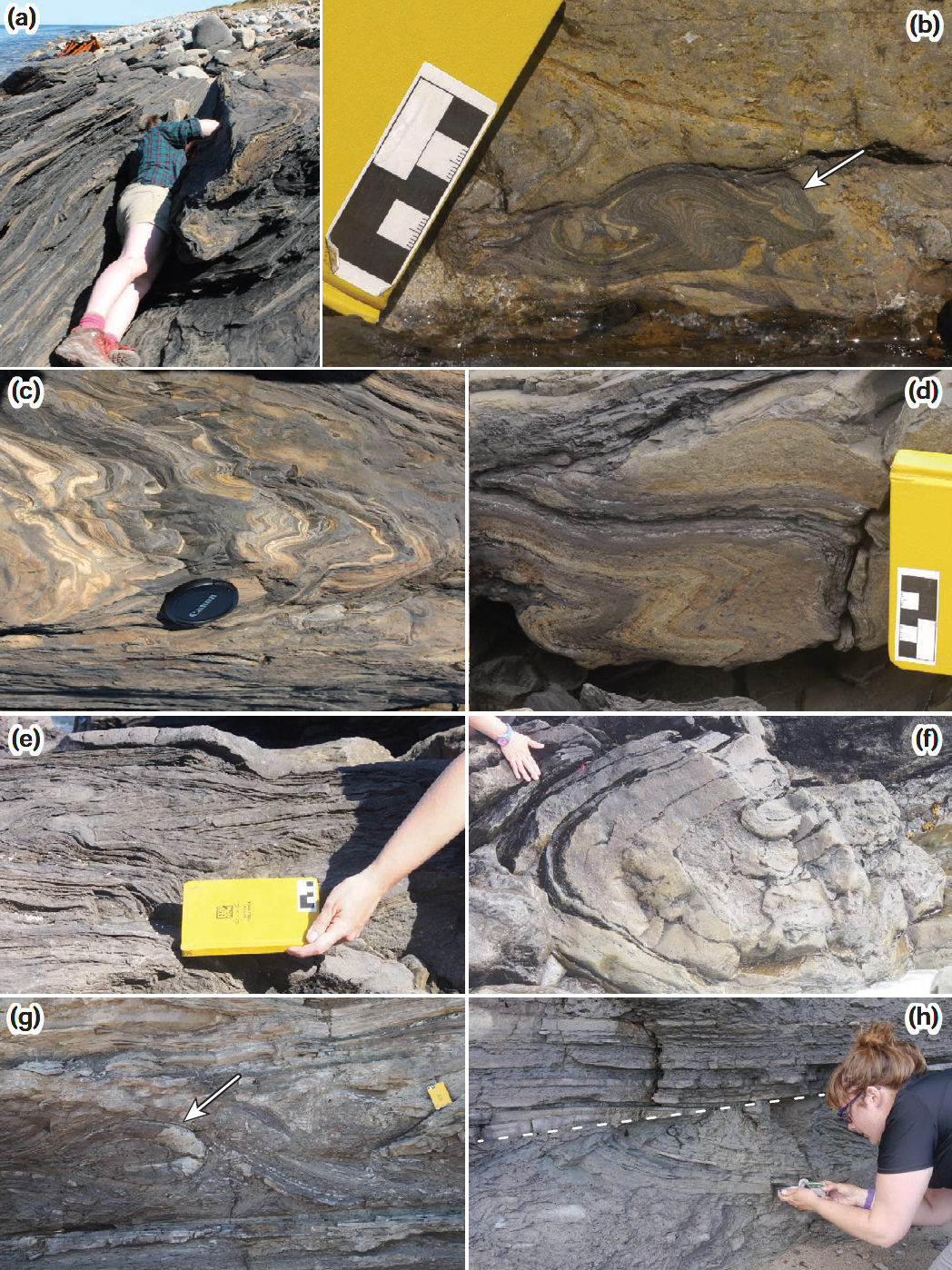
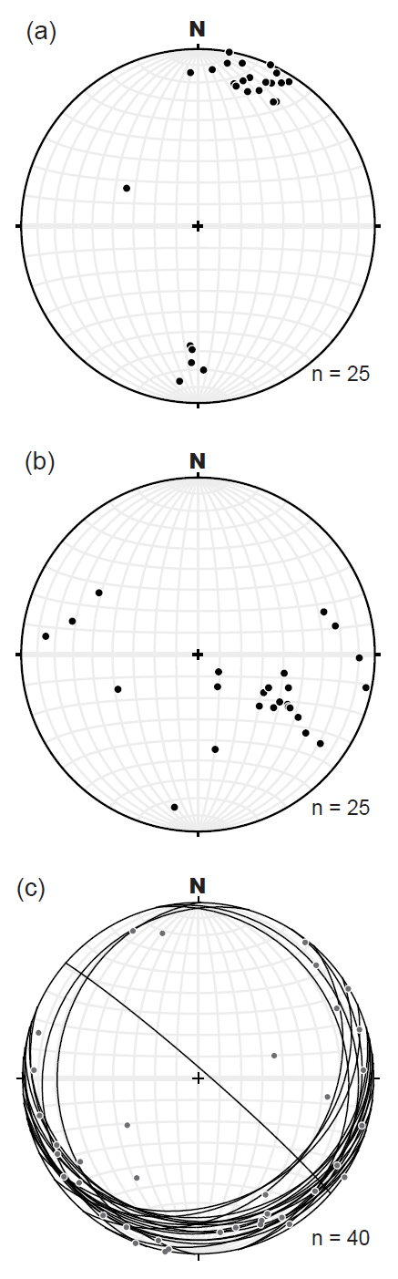
12 In the Anguille Mountains of the southern BSGSB, all four of these formations are present in a succession estimated by Knight (1983) as 2000 to >4900 m thick. However, the succession differs markedly between the northern and southern parts of the sub-basin (Fig. 2); in the north, the Anguille Group is represented only by the 100–200 m thick Fischells Conglomerate in the Flat Bay anticline (Figs. 2, 3), which rests unconformably on Precambrian and early Paleozoic basement.
Codroy Group
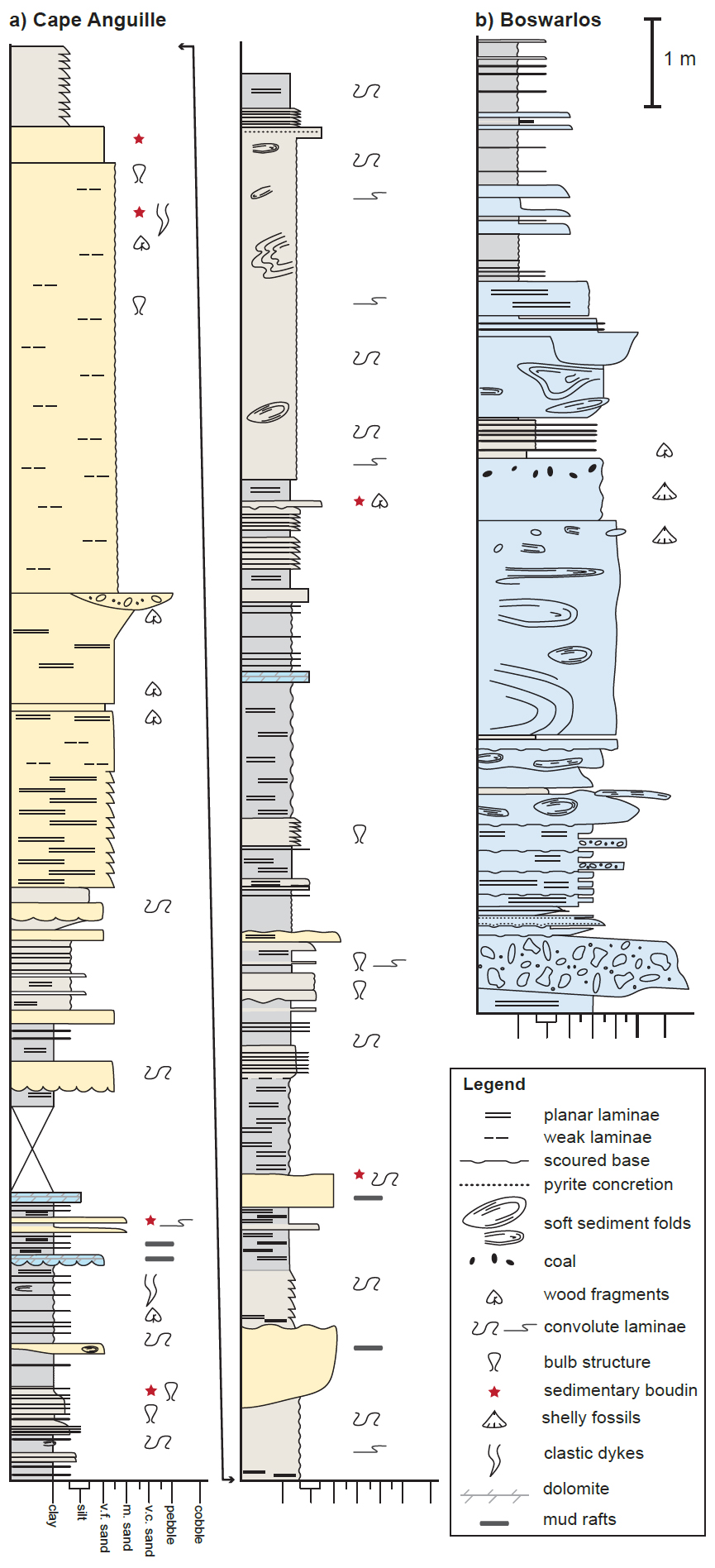
13 The overlying Codroy Group, defined here as equivalent to the Windsor Group and lower parts of the Mabou Group elsewhere in the Maritimes basin (Fig. 3), contains dominantly marine shale, limestone, and evaporite, and represents the only fully marine incursion into the Maritimes basin (Gibling et al. 2008). The Codroy Group was subdivided by Knight (1983) into four formations: Ship Cove, Codroy Road, Robinsons River, and Woody Cape.
14 The contact between the Anguille Group and the basal Ship Cove Formation is exposed at Ship Cove in the north, and on Codroy Island in the south (Fig. 2), whereas at Boswarlos, on the Port au Port Peninsula, the Codroy Group extends beyond the Anguille Group to rest unconformably on older strata of the Humber Zone of the Appalachians. The Ship Cove Formation comprises packstone, oolitic limestone, local boundstone, and minor sandstone. It can be correlated lithologically with the Macumber Formation in Nova Scotia, which lies in an equivalent position at the base of the Windsor Group. Both the Ship Cove Formation and overlying Codroy Road Formation lie biostratigraphically within Windsor Subzone A of Bell (1929) corresponding to the Lycospora pusilla - Densosporites columbaris (PC) Spore Assemblage Zone (Utting and Giles 2004, 2008; Waldron et al. 2017) and the Diplognathodus Conodont Zone of von Bitter and Plint-Geberl (1982) (Fig. 3). Because of the long timespan of these biozones, the age of the basal Vise-an limestone units, and therefore the duration of the break between the Anguille and Codroy groups, has been controversial. The youngest age assigned to the basal Windsor Group is Asbian (~336 Ma), as favoured by Mamet (1970) and St. Peter (1993) in New Brunswick. An older age of early Holkerian (~344–343 Ma) is favoured in most of the work of Utting and Giles (e.g., 2004), but von Bitter et al. (2006) favour a late Chadian age (~345–344 Ma). A single isotopic constraint (Barr et al. 1994) implies that the base of the Windsor Group is younger than 339 ± 2 Ma. In Figure 3 we show the base of the Codroy Group in a compromise position at ~339 Ma, which lies within the Livian sub-stage in the timescales of Davydov et al. (2012) and Aretz et al. (2020), approximately equivalent to the Holkerian substage of NW Europe (Fig. 3).
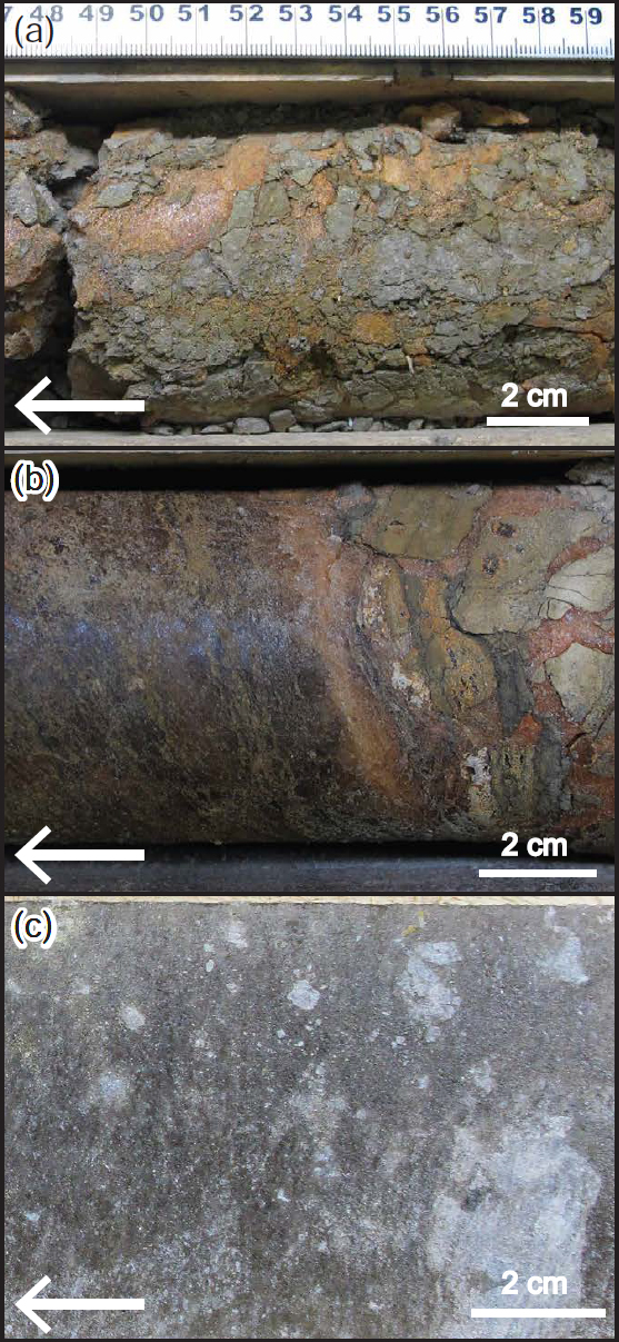
15 The Codroy Road Formation comprises red, grey and multicoloured, locally evaporite-bearing siltstone and sandstone, gypsum, and carbonate, interpreted by Knight (1983) as products of alluvial plain to marginal marine environments. Bell (1948) logged this unit as at least 244 m thick in coastal exposure between Cape Anguille and Capelin Cove (Fig. 2). Knight (1983) logged 145 m of Codroy Road Formation in Fischells Brook, and 300 m in the Codroy Valley. In 1980–1982, approximately 950 m of drill core acquired through the Pronto-Norada Newfoundland Potash Joint Venture in the Flat Bay anticline area (Fig. 2) was logged by Carter and Anderle (Rhoden et al. 1999; D. Carter, Geoscientists Nova Scotia, personal communication 2017). The core was dominantly halite (of various colours, interbedded with clay), anhydrite, siltstone, and limestone of the Codroy Road Formation (Fig. 4). These observations, together with drilling reports by Rhoden et al. (1999) and Dimmell (2001), suggest that outcrop sections of the Codroy Road Formation have been substantially thinned by evaporite removal.
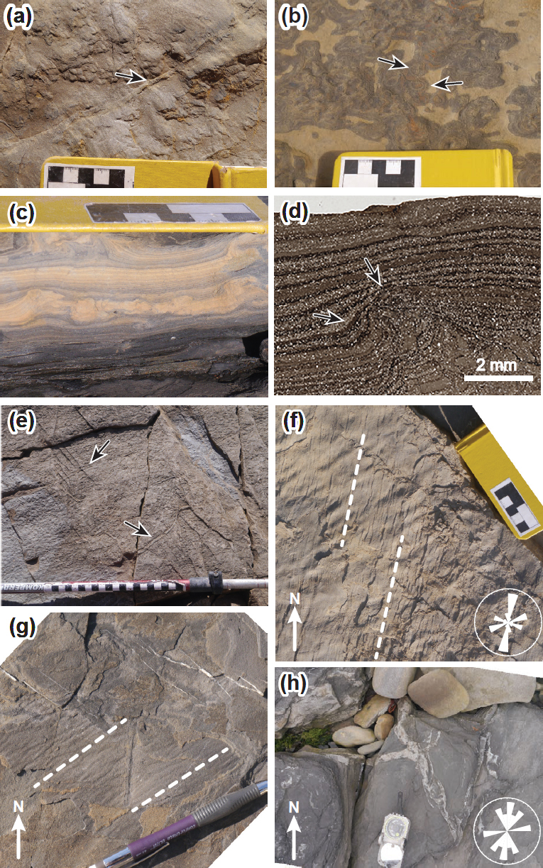
 Display large image of Figure 4
16 The Robinsons River Formation consists of red sandstone, siltstone, and conglomerate, interpreted as floodplain deposits (Knight 1983), with interbedded marine carbonates and evaporites that crop out at Ship Cove, in the Codroy Valley, and along the southwestern coast (Fig. 2). Knight (1983) described the Robinsons River Formation as >5000 m thick, and divided it into four members: Jeffreys Village, Highlands, Mollichignick, and Overfall Brook. However, the Highlands and Overfall Brook members are entirely clastic, and contain Serpukhovian palynomorphs (Utting and Giles 2008); they are here assigned to the overlying Barachois Group (Fig. 3). An additional, laterally equivalent unit, the Woody Cape Formation of Knight 1983), intermediate in biostratigraphic age between the older and younger parts of the Robinsons River Formation, is here treated as a member of that formation.
17 The main sections of Robinsons River Formation between Ship Cove and the Flat Bay anticline are assigned to the Jeffreys Village member. This unit is ~1400 m thick in the Flat Bay anticline (Fig. 2), consisting of shale, mudstone, siltstone, sandstone, conglomerate, minor evaporites, and minor carbonate. The base includes a distinctive and laterally continuous boundstone unit, the Cormorant limestone, that represents the contact between the Taphrognathus and Cavusgnathodus Conodont Zones of von Bitter and Plint-Geberl (1982). The formation contains spores (Fig. 3) extending from the Visean PC to the early Serpukhovian Grandispora spinosa - Ibrahimispores magnificus (SM) Spore Assemblage Zones (Utting and Giles 2004, 2008), corresponding to Windsor Subzones A through E of Bell (1929). The upper contact of the Jeffreys Village member is marked by the top of the Crabbes-Jeffreys limestone of von Bitter and Plint-Geberl (1982) and Utting and Giles (2004, 2008).
18 Two distinct units assigned to the Codroy Group by Knight (1983), restricted to fault-bounded regions in the south and southeast of the sub-basin are here regarded as members of the Robinsons River Formation. The Mollichignick Member, at least 2275 m thick in the Grand Codroy River (Fig. 3), consists of red siltstone, red and grey sandstone, and pebbly sandstone, with minor marine shale and limestone, while the Woody Cape Formation of Knight (1983) consists of approximately 690 m of green and grey mudstone, siltstone, and sandstone interpreted as deltaic deposits (Knight 1983), also with intercalations of marine limestone and shale. This unit only crops out along the southwestern coast at Capelin Cove (Fig. 2) and in a small area inland. Utting and Giles (2004, 2008) place both units in the Visean to Serpukhovian Schopfipollenites acadiensis - Knoxisporites triradiatus (AT) Assemblage Zone, indicating that they are laterally equivalent to the Robinsons River Formation exposed in the Flat Bay anticline and suggesting correlation with the upper Windsor Group. The Mollichignick Member contains palynomorphs characteristic of the upper part (Crassispora maclilosa - Spelaeotriletes arenaceus palynofacies) of the AT Assemblage Zone, suggesting that it is younger than the unit at Woody Cape. There seems to be little justification (except historical precedent) for giving the thinner Woody Cape unit formation status. We therefore suggest that both units are best regarded as members of the Robinsons River Formation. The dominance of clastic sedimentary rocks over carbonates and evaporites in both units suggests that they might have been deposited as minibasin fills during expulsion of lower evaporites within the Codroy Group, in a similar location to minibasin fills interpreted in the Cumberland sub-basin by Waldron et al. (2013).
Barachois Group
19 Knight (1983) defined the Barachois Group to include red conglomerate, sandstone, siltstone, and coal measures (Knight 1983; Gibling et al. 2008; Utting and Giles 2008) that overlie the Codroy Group in the south and east of the BSGSB (Fig. 2).
20 A succession of red sandstone, conglomerate, and red siltstone, >1200 m thick in the St. David’s syncline (Fig. 2), was assigned by Knight (1983) to the Highlands Member of the Robinsons River Formation (Codroy Group). Based on its position above the highest marine limestone, laterally equivalent to Mabou Group rocks in Nova Scotia (Utting and Giles 2004), we include it as the lowest unit in the Barachois Group, necessitating its elevation to formation status. Like its equivalents in Nova Scotia, it contains spores of the early Serpukhovian Grandispora spinosa - Ibrahimispores magnificus (SM) Assemblage Zone. The Highlands Formation represents high sinuosity river channels that traversed arid floodplains (Knight 1983).
21 The ~2500 m thick Searston Formation, comprising grey sandstone, siltstone, and significant coal measures, is attributed to meandering river, floodplain, and swamp environments of deposition (Knight 1983). Abundant palynomorphs of the Reticulatisporites carnosus Assemblage Zone (Utting and Giles 2008) indicate that the Searston is entirely younger than the Highlands Formation. The Over-fall Brook Member, a >345 m thick unit immediately west of the Long Range fault (Fig. 2), is composed of massive cross- bedded and pebbly sandstone. Though this unit was as-signed by Knight (1983) to the Robinsons River Formation of the Codroy Group, Utting and Giles (2008) assign it to the Searston Formation of the Barachois Group based on its similar lithology, lack of marine sediments, and the pres-ence of spores from the Serpukhovian R. carnosus Assem-blage Zone (Fig. 3).
22 Higher strata of the Barachois Group, dominantly grey, were undivided by Knight (1983), but include the Shears and Cleary coal seams of Utting and Giles (2008) that lie within the Serpukhovian R. carnosus Spore Assemblage Zone. Strata are conglomerate, sandstone, mudstone, and coal seams deposited in a fluvial and possibly lacustrine environment (Bell 1948; Baird and Coté 1964; Solomon 1986). We here regard this as an informal formation-level unit, within the Barachois Group.
23 Mudstone, sandstone, conglomerate, and significant coal measures deposited in floodplain environments (Baird and Coté 1964; Solomon 1986; Hyde et al. 1991; Falcon-Lang and Bashforth 2005) occur at Blanche Brook in the north of the sub-basin (Fig. 2). This contentious unit was placed within undivided Barachois Group by Knight (1983) and Hyde et al. (1991) (Fig. 3). However, newer palynological work by Utting and Giles (2008) suggests that the Blanche Brook unit is of Moscovian (Pennsylvanian) age. It is assigned by Utting and Giles (2008; their fig. 15) to the Pictou Group.
STRUCTURE AND DEFORMATION
Large-scale structural contrasts
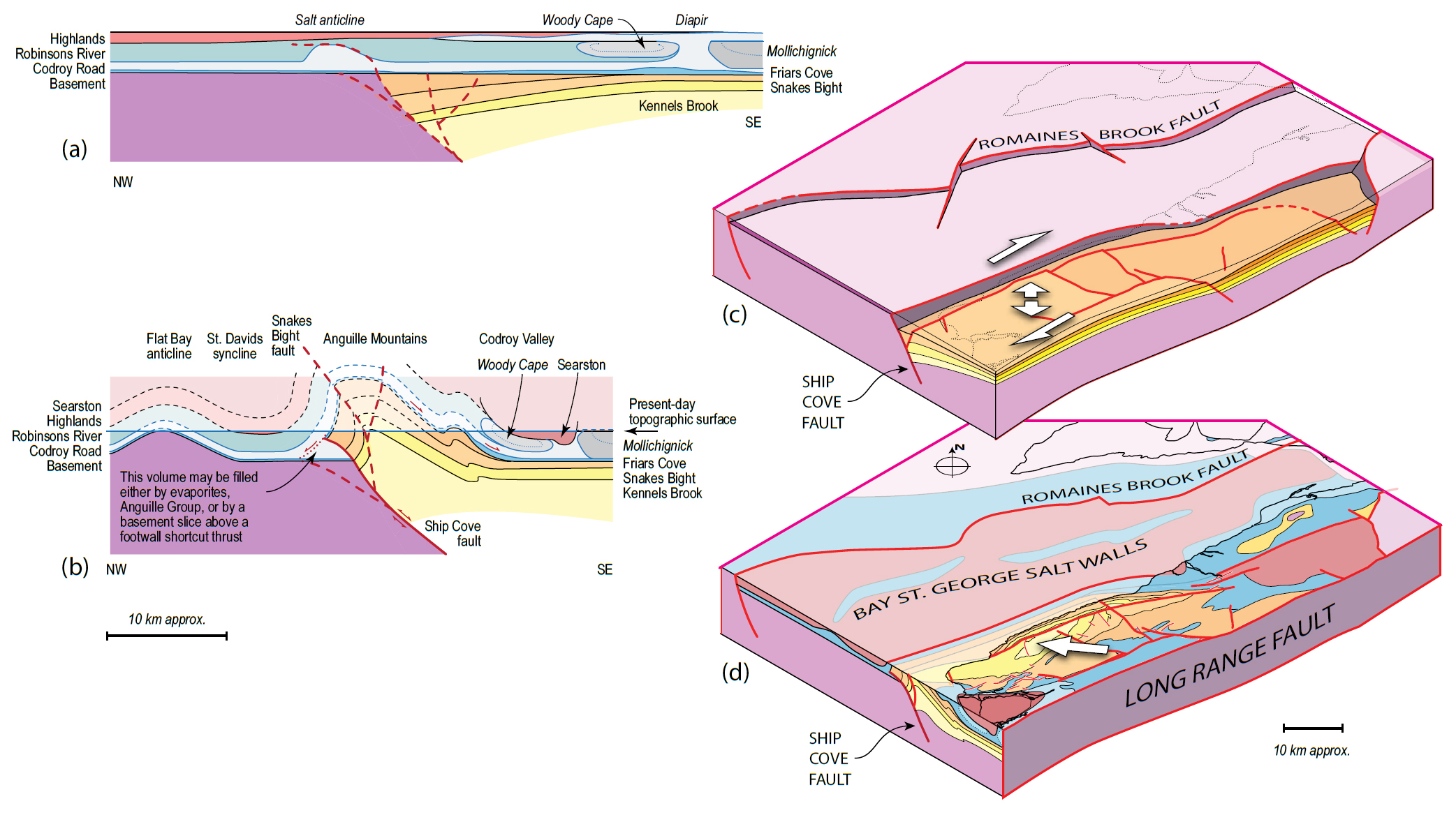
24 The BSGSB is bounded to the south and east by the NE– SW Long Range fault (Fig. 2). Carboniferous strata in the BSGSB unconformably overlie Ordovician strata on Port au Port Peninsula (Fig. 2) and dip generally SE as far east as the basin-bounding Long Range fault, part of the Cabot fault system, leading Knight (1983), Kilfoil (1988), Miller et al. (1990), and Hall et al. (1992) to interpret the Bay St. George sub-basin as a half-graben. Waldron et al. (2015) suggested that the Cabot fault system was active from ~370 Ma to ~310 Ma with a major dextral component of strike slip, representing a major controlling fault of the Maritimes basin. Abundant faults in the BSGSB strike ~NE–SW (Knight 1983), an ori-entation termed the “Appalachian trend” by Waldron et al. (2015); major faults include the Long Range fault and the Snakes Bight fault (Fig. 2). Several smaller NE–SW and NW–SE faults separate Codroy Group strata from Anguille or Barachois Group strata (Fig. 2).
25 Knight (1983) measured steep faults striking E–W in two locations in the BSGSB: Ship Cove and Capelin Cove (Fig. 2). At Ship Cove, multiple E–W faults separate Robinson River Formation from Codroy Road Formation. The E–W fault at Capelin Cove separates Searston Formation (Barachois Group) to the south, and Woody Cape Member (Codroy Group) to the north. We reinterpret these (below) as structures related to evaporite tectonics.
26 Knight (1983) suggested that the northern sub-basin is less structurally complex than the south due to a shallow depth to basement. In the south, Hobson and Overton (1973) used seismic refraction data to suggest the presence of up to 6 km of Carboniferous strata in the sub-basin. Kilfoil (1988) used magnetic and gravity data to determine a depth to basement in the Bay St. George sub-basin as up to 12 km offshore and 3 km onshore. Marillier et al. (1989) interpreted a NW–SE Lithoprobe deep-seismic reflection line southwest of Codroy (Fig. 1), showing a geometry consistent with the half-graben hypothesis. Durling and Marillier (1993) used additional marine seismic reflection data to estimate a depth to the base of the Horton Group ranging from 2 km in the north to >10 km in the south. Sedimentary thicknesses recorded by Knight (1983) suggest that this contrast is due to much greater thicknesses of Anguille Group (>4900 m) in the south, compared with the northern subbasin where it is less than 200 m thick.
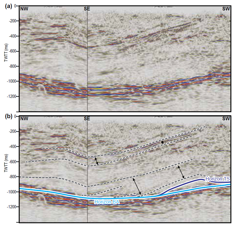
27 Folds in the BSGSB trend generally NE–SW and are typically doubly plunging (Knight 1983). Onshore, the major folds in the northern sub-basin include the Flat Bay anticline and Barachois syncline (Fig. 2). In the southern sub-basin, the dominant fold structure is the Anguille anticline (Fig. 2) the hinge of which roughly parallels the Snakes Bight fault. Knight (1983) noted tight to isoclinal outcrop-scale folds in the thick Anguille and Codroy groups of the southern BSGSB, contrasting with open folds in the north, and in the Codroy Group, suggesting that the contrast is due to the difference in thickness between the two successions. However, a similar contrast in correlative rocks of the Deer Lake sub-basin to the NE (Fig. 1) was attributed by Hyde et al. (1988) to a Mississippian deformation episode following deposition of the Anguille Group.
Outcrop-scale structures: role of soft-sediment deformation
28 To investigate the development of these structures, we remapped and reinterpreted two detailed sections from Ship Cove and Capelin Cove to compare structural style in the northern and southern sub-basin, respectively. We also compared the structures present in the Anguille Group with those in the Codroy Group at Boswarlos on the Port au Port Peninsula (Fig. 2).
29 Many of the structures present show evidence of having been formed before the sediments were lithified, as previously noted by Knight (1983) at Cape Anguille and Codroy Island (Fig. 2). These structures we recorded include soft-sediment folds, bulb structures, sedimentary boudins, and clastic dykes.
Folds
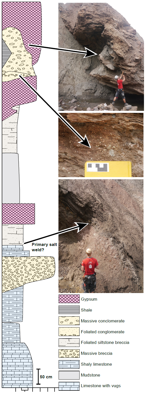
30 Cape Anguille and Codroy Island: The Snakes Bight Formation at Cape Anguille and on Codroy Island displays spectacular folds at a range of scales (Figs. 5a–d). The folded layers are interlaminated siltstone and mudstone (Fig. 6a). Sharp contacts separate deformed layers above and below from undeformed strata. In some locations, rafts containing folded laminae are surrounded by more layers of homogeneous sediment that themselves show larger scale folds (Fig. 5b); as a result, the internal laminated rafts may show superimposed fold patterns (Fig. 5b). Individual folds are tight to isoclinal and range from <1 to 75 cm in half-wavelength measured perpendicular to regional bedding. As shown by a stereographic projection (Fig. 7), folds predominantly plunge gently to the NNE. Their axial surfaces dip moderately NW (Fig. 7). Viewed down plunge these folds are commonly s-folds, verging WNW. Hyde et al. (1988) describe similar tight to isoclinal folds with shallow plunge in Anguille Group strata in the Deer Lake sub-basin (Fig. 1).
 Display large image of Figure 5
31 At outcrop scale, hinges of the folds appear as approximately similar folds: Class 2 of Ramsay and Huber (1987); both sandstone and mudstone layers are thickened in fold hinges. However, on close examination, many sandstone layers show class 1C geometry (i.e., inner surface more tightly curved than outer surface) while adjacent mudstone shows class 3 (i.e., inner arc is less tightly curved than outer arc), indicating that the sand was stronger than mud during deformation, the normal condition for clastic sedimentary rocks deformed at low temperature. However, in some cases sandstone shows class 3 geometry (Fig. 5e), showing that it was weaker than adjacent mudstone at the time of deformation; Waldron and Gagnon (2011) cited this geometry as a clear indicator of deformation while sand was liquidized.
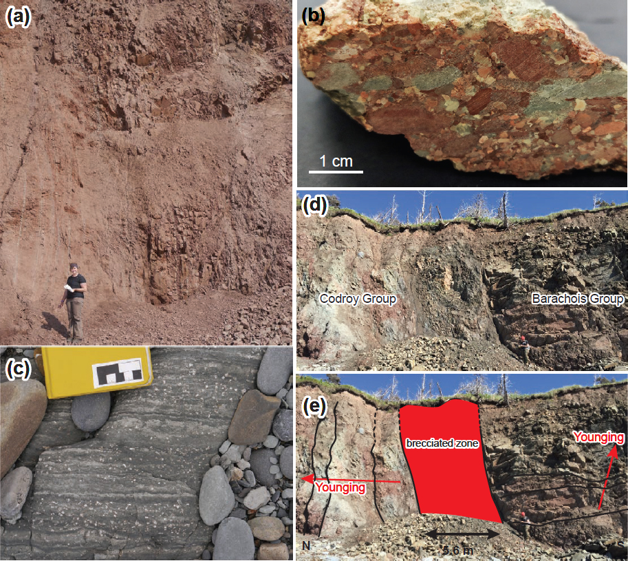
32 Folded siltstone rafts within the larger mass of folded material are common at this location (Fig. 5b). The rafts thin laterally and show convolute laminae suggesting that they were partially lithified. Disaggregation implies that partially lith-ified layers were incorporated as rafts into a larger system of mobile material. Alsop and Marco (2011) and Alsop et al. (2019) have shown similar structures in Late Pleistocene strata adjacent to the Dead Sea and argued that folded strata truncated by undeformed strata of a similar facies, and rafts of folded strata incorporated into a larger structure, are un-equivocal indicators of deformation prior to complete lith-ification.
 Display large image of Figure 6
33 Boswarlos: At Boswarlos (Fig. 2), an angular unconformity between early Paleozoic Humber Zone strata below and Ship Cove Formation above is exposed. Above the unconformity is dominantly very-fine grained to pebbly limestone dipping sub-horizontally (~05°) to the southwest. A detailed stratigraphic column (Fig. 6b) shows four intervals exhibiting tight to isoclinal folds, here attributed to soft-sediment deformation. Undeformed subhorizontal strata truncate limbs and hinges of folds (Figs. 5g, h). These folds comprise tight to isoclinal class 2 (similar) folds, some of which have curved hinges, resembling sheath folds (Fig. 5g). Fold hinges plunge gently, displaying a girdle distribution when plotted together on a spherical projection (Fig. 7c). Plunges of fold hinges on the sheath fold shown in Figure 7 range from 06° to 53° and the folds close to the north and east. Axial surfaces dominantly dip gently S to SW, and strike E to SE. Shear at base of the soft-sediment folds and thinning of limbs indicate transport to the west.
 Display large image of Figure 7
34 Interpretation: Soft-sediment folds comprise strata that were folded prior to complete lithification, in which inter-granular displacements are the main mechanism of deformation (Rossetti 1999; Kang et al. 2010). Soft-sediment folds are commonly attributed to down-slope gravity sliding, but Waldron and Gagnon (2011) pointed out that this is not necessarily the case: unconsolidated sediments are pres-ent in many tectonically active environments where they may undergo soft-sediment deformation associated with the motion of underlying tectonic faults. Folded beds at Cape Anguille and Codroy Island show preferential fold hinge orientations within the overall plane of bedding (Fig. 7). At Cape Anguille the folds trend NNE, have a gentle plunge, and commonly show s-asymmetry verging WNW when viewed down plunge. These observations show that folds at this location likely formed during movement of mobilized sediment downslope towards the WNW, consistent with the direction of paleocurrent flow in the Snakes Bight and Friars Cove formations (Knight 1983). The geometries of folds in both the Anguille Group and Codroy Group examples clearly indicate that sediments were unlithified at the time of deformation but do not clearly indicate whether tectonism, topographic slope, or some combination of the two provided the necessary differential stress to deform the sediments.
Bulb structures
35 At multiple intervals in the Snakes Bight Formation at Cape Anguille (Fig. 6a) are bulbous irregularities that resemble load structures but which crop out on the tops of beds. Cross-bedding and cross-lamination in adjacent sandstone beds clearly indicates that these beds are upright. In plan-view, these structures are approximately 1–5 cm in diameter and appear as rounded siltstone forms within a mudstone matrix (Figs. 8a, b) covering, and protruding from, the tops of siltstone beds. In some locations the exposed bulb structures cover three or more square metres of a single bedding surface.
 Display large image of Figure 8
36 In cross-sectional view, these polygonal structures range described in metamorphic rocks. The extensional structures 1–10 cm in height (Fig. 8c); they are convex-up siltstone bodies surrounded by mudstone. Overlying the structures, laminated finer siltstone and mudstone and siltstone vary in thickness so as to compensate for the greater thickness of coarse siltstone in the convex bulb structures, as shown in thin section (Fig. 8d). These laminae show laterally uniform dip and thickness with the exception of locations immediately above the siltstone bulbs, where they are thinned. The bottom surfaces of the deformed siltstone layers that display the bulbs are undulatory and locally may show conventional (downward protruding) load structures or soft-sediment folds (Fig. 8c). Clastic dykes and sedimentary boudins (described below) cross-cut the structures (Fig. 8e).
37 The structures described above superficially resemble conventional load structures noted, for example, in Turkey by Hempton and Dewey (1983), in Spain by Alfaro et al. (2002) and Ezquerro et al. (2015), in England by Owen (2003) and Collinson (2005), and in a physical simulation by Moretti et al. (1999); the bulb structures differ in being ‘upside-down’. Similar structures have been described with variable names: ‘cycloids’ by Hempton and Dewey (1983) and Scott and Price (1988), ‘mushroom-like silts’ by Rodríguez-Pascua et al. (2000), and ‘bulb-shaped structures’ by Nikolaeva (2009). Closely comparable structures in the Horton Group of the Windsor-Kennetcook sub-basin were described as ‘bulb structures’ by Snyder and Waldron (2016), which is the term used here. In those examples, silt was deposited in layers of uniform thickness and was later deformed, pinching out laterally as a result of sediment flow into the bulbs. The contorted nature of the silt in the bulb structures indicates that sediment was likely liquidized during their formation. Flow of water within the layers and between larger silt grains during liquidization led to density contrasts which enabled the bulbs to rise diapirically into overlying finer-grained muds, accounting for the observed localized variations in grain size and sorting.
Sedimentary boudins
38 Ribbed features exposed on bedding top surfaces are commonly observed within interbedded siltstone and mud-stone of the Snakes Bight and Friars Cove formations (Fig. 6a). In plan view these structures are 1–10 mm wide and create a pattern of parallel hatching on bedding surfaces (Figs. 8f, g). They are commonly found on the top of siltstone and sandstone beds; intervening layers of mudstone do not show the ribbed features. The contacts above and below beds with the ribbed features are parallel; there are no erosional features at the bedding surface. At microscopic scale, the spaces between the sandstone strips are filled by mudstone. These structures show preferential orientation, trending dominantly N–S and NE–SW (Fig. 8f), oblique to fold hinges.
39 These structures are likely produced by extension parallel to bedding in sediments that were incompletely cemented, kinematically equivalent to boudins that are more usually resulted from semi-brittle extension of more rigid siltstone and sandstone; the spaces created between boudins were filled by finer-grained, sediment that clearly behaved in a more ductile manner. As there is both a brittle and ductile component to these structures, they likely formed prior to complete lithification. Their preferred orientation reflects stresses originating from slopes or from tectonic deformation of wet sediment. Comparable features were described as “pull-apart structure” by Corbett (1973) in turbidites from Tasmania. Other examples of sedimentary boudins were described by Waldron et al. (2007) and Snyder and Waldron (2016) in correlative rocks in the Windsor-Kennetcook sub-basin in Nova Scotia.
Clastic dykes
40 Clastic dykes in the Snakes Bight Formation occur in interlaminated siltstone and mudstone layers (Fig. 6a). Dykes are composed of grey siltstone and cross-cut dark grey mud-stone at a high angle to bedding and bedding-parallel fissility. The dykes range from 4–14 cm in height (i.e., perpendicular to bedding), and 5 mm–14 cm in width as measured where they are visible on the top surfaces of beds, but narrow with depth. The dykes are elongate, striking dominantly NE–SW, confirming the observation of Knight (1983). Where multiple dykes occur in one horizon, they are most often aligned parallel to each other, but some sections show perpendicular dykes trending NW–SE (Fig. 8h). We did not observe tightly contorted clastic dykes with the geometries seen in the Horton Group of Nova Scotia, interpreted as the result of compaction of surrounding mud (Martel and Gibling 1996; Snyder and Waldron 2016). However, this may have been because the majority of dykes were observed on bedding surfaces, not in cross-section.
41 The clastic dykes are wider at the top and thin with depth, typically originating in a single coarser bed but terminating at different stratigraphic intervals, indicating that the dyke fills were sourced downward from above. They clearly developed before the sediment was fully lithified. However, the contacts between siltstone and adjacent mudstone are sharp, which suggests brittle deformation of mud at a shallow depth of formation (Parnell and Kelly 2003). Waldron and Gagnon (2011) argued that when mud acts more rigidly than coarser sediment, it indicates that the coarser sediment behaved as a fluid with a lower yield stress than the mud, suggesting that the dyke-filling silt was mobilized by sediment liquidization, while the surrounding mud was sufficiently dewatered to undergo brittle deformation.
42 The clastic dykes at Cape Anguille cross-cut sedimentary boudins and soft-sediment folds (Fig. 8e). The top surface of one sandstone bed shows a bedding-parallel fault (219/23 NW) and clastic dykes on the same surface. The sandstone fill of the clastic dyke appears in positive relief clearly cross-cutting gently WSW-plunging (254-14) slickenlines (Fig. 8a.), which indicates that the dyke formed after the fault moved.
Interpretation
43 Soft-sediment deformation structures are features that form soon after deposition of sediment and before complete lithification. Soft-sediment structures provide information on early deformation of sedimentary rocks in tectonically active environments such as strike-slip systems and sedimentary basins cut by faults (Hempton and Dewey 1983; Plint 1985; Rossetti 1999; Sibson 2003; Berra and Felletti 2011; Waldron and Gagnon 2011; Snyder and Waldron 2016; Tang et al. 2020). Liquidization (liquefaction and/or fluidization) is the most common deformation mechanism (Maltman 1994; Maltman and Bolton 2003; van Loon and Mazumder 2011, Alsop et al. 2019). Liquidization of sediment commonly occurs at or near the sediment–water interface, although if unlithified wet sediments are sealed by an overlying impermeable layer, overpressured conditions may develop, and liquidization can therefore occur deeper in a sediment pile (Maltman and Bolton 2003; van Rensbergen et al. 2003). Overpressure can liquidize a fluid-saturated bed if it is either rapidly buried or horizontally compressed by tectonic processes (Maltman 1994; Jolly and Lonergan 2002; Maltman and Bolton 2003; Taki and Pratt 2012).
44 The soft-sediment deformation structures described above can be broadly classified into those that were exposed at the sediment–water interface and those that formed later in the sediment pile. Alsop et al. (2019) note that structures truncated by undeformed strata are an indication of formation near the sediment surface, before minor erosion. Amongst the structures we observed, soft-sediment folds are in some cases truncated and unconformably overlain by undisturbed strata, suggesting that they formed near the sediment surface.
45 The sedimentary boudins and bulb structures show no evidence of exposure at sediment surfaces; both are best explained as products of liquidization during overpressuring, where overlying impermeable mudstone (or evaporite) provided a seal and prevented the expulsion of interstitial water during burial. The lack of erosional features and presence of overlying mudrock suggest these structures formed within the sediment pile after some amount of burial. Sedimentary boudins were observed to cross-cut the bulb structures, indicating that these structures also probably formed within the sediment pile.
46 Clastic dykes show diverse relationships. In some cases they were truncated at the sediment surface, whereas in other cases they cross cut features such as sedimentary boudins and bulb structures, indicating formation within the sediment pile. A single example of a dyke cutting a fault with subhorizontal slickenlines (Fig. 8a) suggests that strike-slip faulting was active during early stages of diagenesis. Clastic dykes may therefore have formed at intervals throughout deposition and early stages of diagenesis.
47 A range of triggering mechanisms are recognized to have the potential to create soft-sediment deformation structures of the types identified in the BSGSB. These include meteorite impact, tsunami, permafrost thawing, groundwater fluctuations, paleoslope, wave and tide action, seismicity, rapid sediment loading, and overpressured conditions (Moretti et al. 1999; Alfaro et al. 2002; Moretti and Sabato 2007; Owen and Moretti 2011; Hermanrud et al. 2013; Alsop et al. 2019; Tang et al. 2020). Many of these can be excluded as the trigger for deformation in the BSGSB. Soft-sediment deformation structures are present on multiple, closely spaced stratigraphic surfaces; explanations that invoke large, rare events, such as tsunami and meteorite impacts (Long 2004; Tang et al. 2020) are unlikely. Permafrost may be eliminated as a cause because, at the time of deposition, Newfoundland was at a low latitude in a warm climate (Calder 1998). Preferential orientation of many of the structures suggests that vertical fluctuations in the groundwater table are not a likely trigger for deformation.
48 Waldron and Gagnon (2011) show that soft-sediment deformation structures with preferred orientation can be induced by down-slope gravity-driven processes, by movement on underlying tectonic faults, or by combinations of the two (for example, where tectonic activity produces steep topographic slopes). Because soft-sediment folds are observed in three different formations (Snakes Bight, Spout Falls, and Ship Cove), we suggest that the BSGSB was tectonically active throughout deposition of the Anguille Group, and that deformation continued into deposition of the Ship Cove Formation of the Codroy Group. However, at its type locality the Ship Cove Limestone is uniform, with no soft-sediment structures. This distribution suggests that soft-sediment deformation was localized, possibly to the vicinity of active faults. The immediate triggers for soft-sediment deformation may have included causes as diverse as rapid sediment loading, waves, tides, and seismic shaking (Sims 1975; Gatmiri 1990; Rossetti 1999; Owen and Moretti 2011; Moretti et al. 2016). Regardless of the immediate trigger, the presence of soft-sediment structures with tectonically controlled orientations shows that tectonism was active during sedimentation. Our observations suggest that part of the contrast in deformation style between the northern and southern BSGSB may be due to the abundance of soft-sediment deformation structures in the thick, rapidly- deposited strata of the southern sub-basin.
Map-scale structures: role of evaporites
49 Large-scale tectonic structures onshore have been noted by Knight (1983) and include the Flat Bay anticline and Barachois syncline in the north and the Anguille anticline and the Snakes Bight fault in the south.
Drilling data
50 Mineral exploration directed at gypsum, potash, and halite in the Codroy Group in the Flat Bay anticline area (Fig. 2) has produced a significant amount of drilling data. Rho-den et al. (1999) examined drill core from Leeson Resources Inc. LR-98-1 and LR-98-2, east of the Flat Bay anticline (Fig. 2) in the northern part of the basin, and interpreted a salt-expulsion minibasin in the area. The two wells penetrated 681 m and 359 m of Carboniferous strata, respectively. Drill core contains sandstone, siltstone, mudstone, conglomerate, and an increasing amount of evaporites (gypsum and halite) with depth; halite is the dominant lithology below ~360 m in LR-98-1 and LR-98-2 (Rhoden et al. 1999). Immediately above the Ship Cove Formation, the Codroy Road Formation is logged as thick foliated intervals of dominant halite and anhydrite with frequent limestone bands. The thick halite package contains bands and/or inclusions of mudstone and siltstone that make up between 2 and 40% of the drilled section (Fig. 4). We infer that stratigraphic sections exposed in outcrop, now devoid of halite, originally contained significantly larger proportions of evaporite, and that sections of siltstone breccia observed in outcrop represent residues, after solution, of originally much thicker successions of interstratified siltstone and evaporite in the subsurface.
Seismic reflection data
51 To supplement outcrop and drill-core information, time-migrated 2-D seismic reflection data were acquired from the Newfoundland and Labrador Department of Natural Resources (Figs. 2, 9). The data are of poor to moderate quality, and we have not attempted any reprocessing. Initial horizon identification and interpretations were made by comparison with maps, drill core, and data from offshore BSGSB. Because we lack logged wells tied to the seismic lines, our horizon interpretations are necessarily tentative. Nonetheless, we identify evaporites based on their lack of coherence and weak internal reflectivity. Evaporites are commonly recognizable on seismic profiles from passive margins as zones of incoherent low reflectivity (Jackson and Hudec 2017) showing major fluctuations in thickness, an interpretation confirmed from our experience in other parts of the Maritimes basin, where thick evaporites (“lower Windsor salt”) commonly occur above a highly reflective basal anhydrite interval (gypsum in outcrop), that in turn rests upon limestone (Macumber Formation and equivalents).
52 Based on the above arguments we identify a consistent deep reflection (horizon BA, possibly representing a basal anhydrite unit of the Codroy Road Formation that represents the boundary between bright but poorly coherent reflections below and a discontinuous convex-up zone of incoherent reflections above, interpreted to represent evaporites.
53 Above both these units is a reflective interval that defines antiform-synform pairs (Fig. 9). The base of this reflective interval can be traced across most lines, here termed horizon TS (Fig. 9) possibly representing a top-salt reflection. In parts of the section where the inferred evaporites are absent, BA and TS join to form a single reflection. Horizons in the moderately reflective package above TS appear to downlap directly on to the merged BA-TS surface. To the southeast, reflections overlying horizon TS, dipping moderately to the southeast, change dip to parallel the subhorizontal horizon BA. We interpret these relationships to suggest that the lenticular interval between BA and TS represents remnants of an originally more continuous evaporite layer that has been expelled from the section into adjacent salt structures.
 Display large image of Figure 9
54 The interval above horizon TS shows significant variations in two-way travel time between reflections across the seismic profile, interpreted to indicate thickness changes. On the line shown in Figure 9, thickness between reflections increases near the hinge of a syncline; thickness between reflections decreases near the hinge of an anticline.
55 The geometries on these seismic lines are similar to salt- related structures on passive continental margins (Hudec et al. 2009) where expulsion of evaporites is caused by younger sediment subsiding into an evaporite-filled layer. Lateral thickness changes in overlying sediment record differential subsidence during sedimentation. The surface where material above and below the evaporite package (horizon TS and horizon BA) are juxtaposed is therefore interpreted as a primary salt weld (Fig. 9).
Ship Cove Section
56 Ship Cove (Fig. 2) was mapped by Knight (1983) and von Bitter and Plint-Geberl (1982) as a continuous conformable succession spanning the Spout Falls, Ship Cove, Codroy Road, and Robinsons River formations. We remapped this area and measured a detailed section from the top of the Ship Cove Formation into the base of the Codroy Road Formation (Fig. 10). In this section, laminated limestone, mud-stone, massive conglomerate, gypsum, and multicoloured weakly foliated siltstone breccia (Figs. 11a, b) alternate. Thin beds of gypsum occur within the siltstone breccia packages. The repetitive character of the succession suggests that the Codroy Road Formation was deposited during cyclic changes in the depositional environment. Giles (1981, 2009) interpreted correlative rocks from the Windsor Group in the Shubenacadie sub-basin in Nova Scotia and noted similar cycles at mesoscopic and macroscopic scale. von Bitter and Plint-Geberl (1982), Utting and Giles (2004, 2008) revisited these sections focusing on conodonts and palynomorphs respectively. These results were incorporated into our sections, resolving questions on younging and dip directions.
 Display large image of Figure 10
 Display large image of Figure 11
57 The new map and cross-section in Figure 12 show uniformly dipping Spout Falls and Ship Cove Formation at the stratigraphic base of the section. Above these units, the cross-section (C–D in Fig. 12), perpendicular to major fold axes, shows alternating folded sections of foliated siltstone breccia, gypsum, and minor carbonates. The gypsum sections have varying texture, but consistently show foliated dark and light bands in which the foliation is broadly parallel to layering. The lithological intervals can be broadly correlated across folds, but map relationships require that the thickness of the lowest Codroy Road Formation gypsum varies dramatically when traced laterally, which suggests extreme ductility due to evaporite flow. In the overlying Codroy Road Formation, a series of anticline–syncline pairs comprise the remainder of the section. Interbedded boundstone, sandstone, siltstone breccia, and gypsum form a large anticline further north. Gypsum outcrops near the core of this anticline are steeply foliated at water-level, but the foliation is itself folded about a near-horizontal secondary axial trace, suggesting the presence of refolded folds.
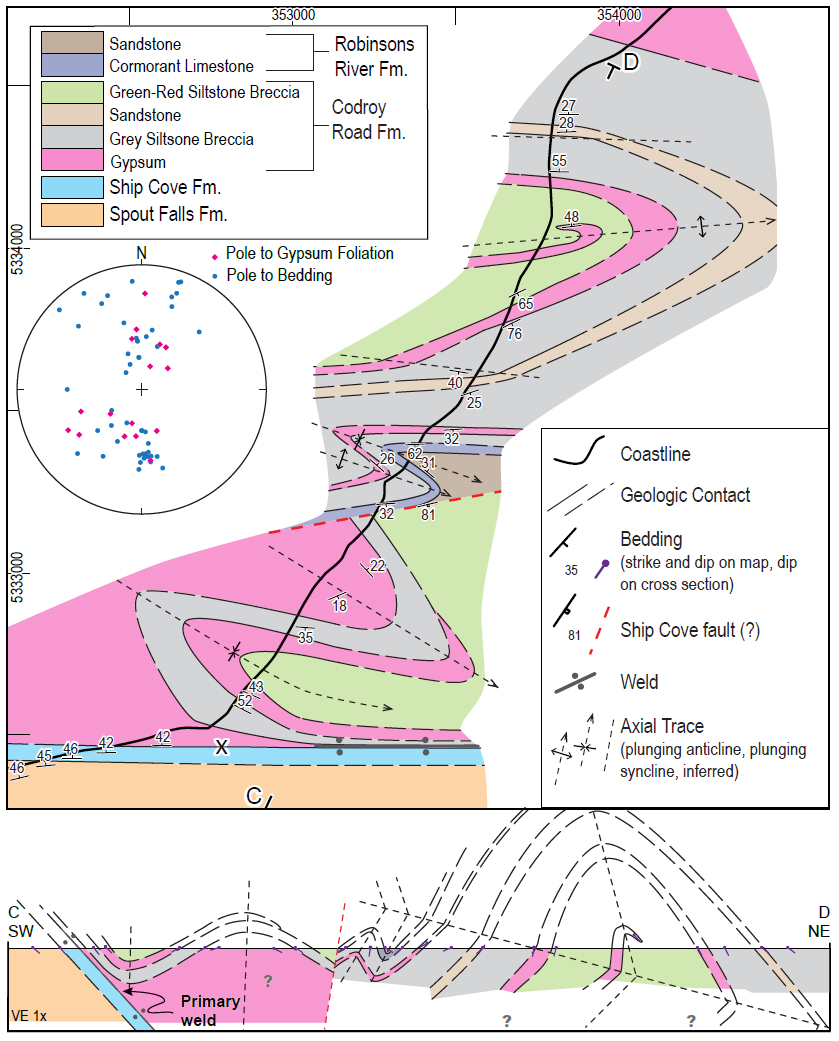 Display large image of Figure 12
58 We interpret expulsion of evaporites along the top of the Ship Cove Formation that created the thickened evaporite package shown in the cross-section in Figure 12. The parallel contact between the Ship Cove Formation limestone and an overlying siltstone breccia and gypsum (Fig. 10) likely represents a surface where evaporites were expelled or dissolved forming a primary salt weld.
Capelin Cove Section
59 One of the most structurally complex coastal sections in the BSGSB mapped by Knight (1983) extends from Stormy Point to Cape Anguille (Fig. 2), passing through Capelin Cove. For this study, the Capelin Cove section was remapped (Fig. 13). The strata were separated into three mappable siltstone breccia units, two separate gypsum-dominated packages, and two black limestone packages (Fig. 13).
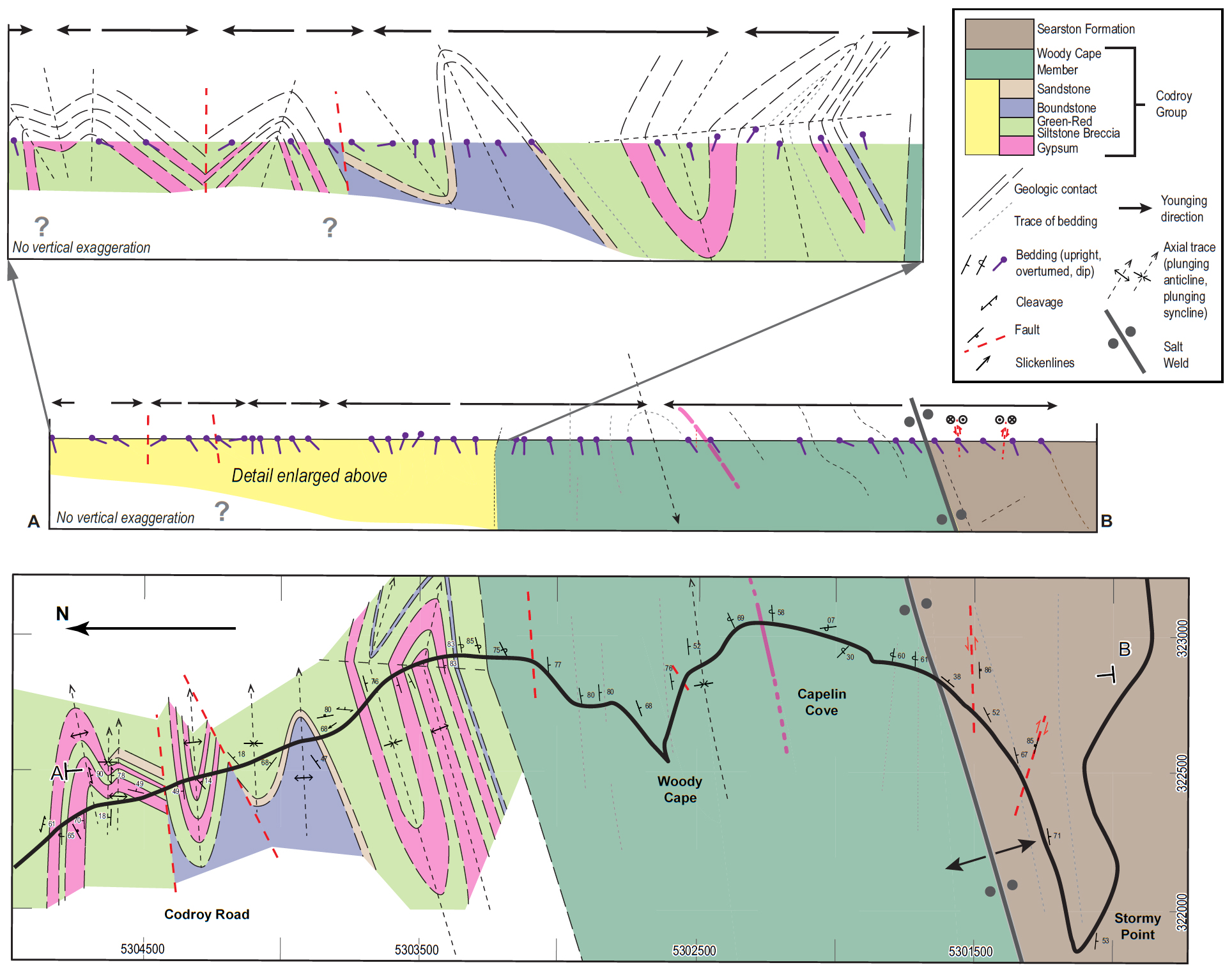 Display large image of Figure 13
60 To the south of the Capelin Cove section are sandstone, dark shale, siltstone, and rare gypsum beds of the Woody Cape Member. One sandstone bed within the member has quartz pseudomorphs after halite (Fig. 11c) suggesting that parts of the Woody Cape Member were deposited in hyper-saline water. Crossbedding and climbing ripples in the sandstone provide unequivocal way-up indicators. This package of rock has variable dip, ranging from steeply dipping (~75° south) and younging to the south, to near horizontal (~07° north), to overturned (~58° south) and younging to the north (Fig. 13). The pattern of bedding orientations clearly shows that the Woody Cape Member is folded in a downward-facing fold: an antiformal syncline. Such structures typically require two episodes of shortening in their formation, the first to form an upward-facing fold and the second to rotate it so that strata at the hinge are upside-down.
61 The contact between Woody Cape Member and Searston Formation to the south comprises a near-vertical brecciated zone exposed in the cliff. The contact zone is ~5.5 m wide and strikes approximately E–W (250°) (Figs. 11d, e). Within this zone is fine-grained very poorly consolidated breccia and gouge. Broken sandstone layers are present near the edges of the zone, with orientations subparallel to bedding in the adjoining units. Multiple surfaces on the competent rocks display slickenlines and deformation bands of varying orientations.
62 To the south of the brecciated zone are sandstone, siltstone, and coal measures of the Searston Formation that dip 50–60° and young to the southeast. Searston Formation rocks measured inland also young to the south and east forming a synclinal elliptical pattern (Fig. 2).
63 The contact between Woody Cape Member and Searston Formation was interpreted by Knight (1983) as the steeply dipping Stormy Point fault, striking approximately east-west. Traced inland, this structure passes through a poorly exposed valley of the Grand Codroy River, interpreted by Knight (1983) as underlain by a belt of Codroy Group between the Anguille Mountains to the north and a structural basin filled with Searston Formation (Barachois Group) which lies to the south. However, the diametrically opposed younging directions of the formations on either side of the interpreted fault make reconstruction of fault slip very diffi-cult. In contrast, the configuration of two oppositely younging, steeply dipping formations, separated by breccia, closely resembles the geometry of some salt welds observed in seismic profiles of passive continental margins (Jackson and Hudec 2017). Secondary salt welds represent steeply dipping zones where salt migrated into a diapiric salt wall, and tertiary salt welds represent subhorizontal salt canopies; in both cases a weld is formed when salt is expelled from the wall or canopy, and the resulting weld may show divergent younging directions of strata preserved on either side. Secondary and tertiary salt welds are rare in outcrop. However, the structure at Capelin Cove resembles salt welds described by Rowan et al. (2012) in the La Popa Basin in Mexico and by Thomas and Waldron (2017) at Little Judique, Cape Breton Island in rocks of comparable age in the Maritimes basin. It is therefore interpreted that the contact separating Woody Cape Member and Searston Formation is a salt weld, not a fault. The brecciated zone represents the material left after salt expulsion or solution. Bedding measurements from the Searston Formation, to the south and inland (Fig. 2) outline an elliptical structural basin suggesting that the Searston Formation strata occur within a salt-expulsion minibasin. Inland, the expression of the salt weld could route through Grand Codroy River (Fig. 2), which is a low elevation area with poor exposure consistent with the former presence of a diapiric evaporite wall. To the north, the Woody Cape Member probably represents an earlier, late Visean minibasin that also subsided into salt of the Codroy Road Formation. The downward-facing fold in the Woody Cape Member probably represents an originally recumbent, SE-facing fold that formed during late Visean minibasin subsidence and development of a salt canopy as shown schematically in Figure 14a. Expulsion of salt from the canopy allowed deposition of the Searston Formation above. Subsequent tilting associated with the development of the Anguille anticline rotated the fold into its downward-facing orientation (Fig. 14b). We therefore reinterpret the Stormy Point fault of Knight (1983) as a Serpukhovian salt weld.
 Display large image of Figure 14
Snakes Bight fault and associated structures
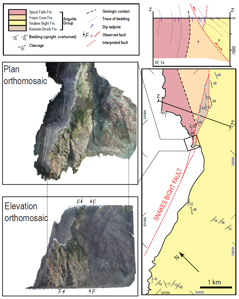
64 The Snakes Bight fault (Fig. 2) is the largest fault within the onshore Bay St. George sub-basin separating Carboniferous stratigraphy. The fault comes onshore at Snakes Bight, striking NE–SW. Knight (1983) mapped the Snakes Bight fault as striking more E–W at Ship Cove near the boundary between the southern and northern sub-basin (Fig. 2). Figures 2 and 3 show that the Snakes Bight fault lies ~5 km southeast of the subsurface boundary between contrasting Anguille Group stratigraphies of the northern and southern sub-basins. We therefore suggest that the Snakes Bight fault branches off a deep subsurface normal fault, here termed the Ship Cove fault, that separates the northern and southern sub-basins.
65 Figure 15 shows a detailed map of the Snakes Bight area. A vertical orthomosaic of Snakes Bight, made in the photogrammetry program Agisoft Photoscan, shows bedding orientation differences on either side of a narrow fault-bounded section. To the west is slightly overturned red sandstone of the Spout Falls Formation, the youngest formation in the Anguille Group, that youngs to the west. The area north of Snakes Bight shows the older Spout Falls Formation, steeply dipping and also younging to the west. To the east of the faults are moderately inclined mudstone and siltstone of the Snakes Bight Formation younging to the east. The fault-bounded area in the centre consists of moderately to steeply dipping grey conglomerate and sandstone of the Kennels Brook Formation, the oldest formation in the Anguille Group, that youngs to the east. At two locations (marked with an x in Fig. 15), we observed brecciated rocks with no measurable bedding. Z-Z’ in Figure 15 shows a cross-section perpendicular to both faults. The hanging wall of the northern fault (footwall of the southern fault) is the only place where Kennels Brook Formation crops out. The hanging wall of the southern fault is the higher stratigraphy of the Snakes Bight Formation. We interpret the fault to the north as a footwall shortcut thrust, branching off the main Snakes Bight fault (southern fault).
 Display large image of Figure 15
DISCUSSION
Extensional geometry of the Bay St. George sub-basin
66 The Bay St. George sub-basin formed during Devonian subsidence and strike-slip motion along major NE–SW faults, including the Long Range fault, that created the Maritimes basin (Gibling et al. 2008; Hibbard and Waldron 2009; Waldron et al. 2015; Gibling et al. 2019). Initial deposition into the Bay St. George half-graben started with the Tournaisian Anguille Group. The Anguille Group is dramatically thicker in the southern sub-basin compared to the northern sub-basin. In the hanging wall of the Ship Cove fault, a thick package of Kennels Brook, Snakes Bight, Friars Cove, and Spout Falls formations is exposed in the Anguille anticline and surrounding area (Figs. 2, 15). In the footwall, the Anguille Group rapidly thins, such that only ~150 m remains in the Flat Bay Anticline. This suggests that the Ship Cove fault and the NW limb of the Anguille anticline approximately marks a SE-side-down growth fault active during the Tournaisian. Continuing movement allowed accumulation of much thicker Anguille Group strata on the SE side.
Tectonic environment of soft-sediment deformation
67 The Snakes Bight, Friars Cove, Spout Falls, and Ship Cove formations record a protracted history of soft-sediment deformation. Bulb structures are interpreted to have formed by liquidization of already buried sediment and are very commonly cross-cut by other soft-sediment structures suggesting continuing liquidization during deposition. As the complexly folded beds and bulb structures occur in multiple sections within the Snakes Bight Formation and continue into the Friars Cove Formation, we infer that the sub-basin was tectonically active throughout deposition.
68 At Cape Anguille, soft-sediment folds shed light on the timing of deformation. The rafts of folded laminae within larger masses of convolutely folded material (Fig. 5) formed when partially-lithified layers broke and became part of a larger folded system. The structures in these rafts would have formed early in the deformation process; the rafts separated and became incorporated into the larger soft-sediment fold, later in the deformation history. Similar soft-sediment folds in the overlying Ship Cove Formation suggest that the sub-basin remained tectonically active into the Visean.
69 The bulb structures and sedimentary boudins do not show evidence of interaction with the sediment-water interface; our observations suggest that they formed deeper in the sediment pile during a period of overpressure. In sedimentary basins, either rapid burial of sediment or tectonic strain can induce overpressured conditions (Osborne and Swarbrick 1997), and seismic shaking can trigger soft-sediment deformation. Therefore, rapid burial of the Snakes Bight Formation, and/or tectonism associated with the active Snakes Bight fault, probably created overpressure and led to formation of the observed suite of soft-sediment deformation structures.
70 These structures, and the paleocurrents and thickness changes in the Anguille Group (Knight 1983), suggest a model in which the southern part of the basin was actively tilted down to the WNW by a synsedimentary extensional component of movement on the Snakes Bight fault or its precursor, forming a westward-thickening half-graben. While the basin was under-filled, paleoslope was also down towards the WSW; Knight (1983) notes a combination of axial and westward paleocurrents in the Snakes Bight and Friars Brook formations. Seismic shaking during episodes of fault movement may have led to liquidization of the waterlogged sediments; sliding of portions of the sedimentary pile toward the fault led to the development of soft-sediment folds and sedimentary dykes. The direction of topographic slope may have been reversed as the basin became over-filled during deposition of the Spout Falls Formation; Knight (1983) records paleocurrents towards the SE at this time. Our observations do not allow us to unequivocally determine the direction of transport that produced the soft-sediment folds in the Spout Falls and higher units.
71 Following deposition of the Anguille Group, the basal unit of the Windsor Group, the Ship Cove formation, was deposited over a wider area, and is relatively constant in thickness, suggesting decreased tectonic activity. A corresponding unit in Nova Scotia, the Macumber Formation, shows a similar relationship, suggesting deposition in an environment of relatively uniform subsidence, contrasting with the horstand-graben tectonics that characterized the Horton Group (Pascucci et al. 2000). However, fault movement and tilting continued in parts of the Maritimes basin (e.g., Waldron et al. 2013) and may explain the continuing soft-sediment deformation seen in the Codroy Group at Boswarlos.
Timing of evaporite movement
72 The evaporite units in the BSGSB have been highly deformed but also dissolved in the exposed sections; as in most evaporite basins, the evaporites themselves preserve little direct evidence of the timing of deformation. Typically, in evaporite successions, overlying minibasin sediments provide the best control in the timing of salt movement. In the BSGSB, several units have characteristics that suggest deposition in minibasins on top of moving evaporites.
73 In the northern sub-basin, the St. David’s syncline (Fig. 2) has an orientation unrelated to most other folds in the sub-basin, which is not easily reconciled with dextral strike-slip on the Appalachian or Minas fault trends of Waldron et al. (2015). Our observations of thickness variations at and north of Ship Cove suggest that salt movement was a significant player in the deformation history. The geometry of the St. David’s syncline is consistent with a salt-withdrawal minibasin, suggesting salt movement in the early Serpukhovian.
74 Farther south, at Capelin Cove, an interpreted salt weld bounds an elliptical periclinal syncline filled with Searston Formation, also closely similar to the geometry of salt- expulsion minibasins in passive-margin settings (e.g., Hudec and Jackson 2007). This suggests that salt expulsion continued into the later Serpukhovian.
75 Finally, and more speculatively, the Woody Cape Member, to the north of the interpreted salt weld at Capelin Cove, displays dramatically different facies from the time-equivalent strata of the Mollichignick Member. The presence of halite pseudomorphs within the section (Fig. 11c) suggests that a source of halite-rich surface water was present during deposition, whereas the absence of limestone and gypsum implies that this was not sea-water. We suggest that the halite was derived by solution of evaporite diapirs that were already breaching the surface during the late Visean deposition of the Woody Cape Member, and that this laterally confined unit may represent a third minibasin. If correct, this would imply that Codroy Group evaporites were moving from Visean to Serpukhovian time.
Tectonic inversion
76 The map pattern of the southern Bay St. George sub- basin (Fig. 2) shows thick Anguille Group strata exposed at the surface at a higher structural level than its position in the northern sub-basin, suggesting SE-up movement along the approximate line of the Ship Cove fault. The thickness variations in the Anguille Group clearly suggest that the present-day Ship Cove fault marks the approximate line of a SE-down basin-bounding fault that was active during the Tournaisian (Fig. 14). These relationships show that the boundary has undergone inversion at some time since deposition of the Anguille Group. Field relationships at Snakes Bight (Figs. 14, 15) suggest that the originally SE-dipping normal fault was rotated to near-vertical during the inversion process.
77 The amount of separation across the Ship Cove and Snakes Bight faults decreases northeastward. Where the fault is dominantly NE-striking, the relative uplift of the south side is large, whereas the east-striking part shows a much lower degree of inversion. This is perhaps explained by inversion during dextral strike slip on faults with the E–W “Minas trend” of Waldron et al. (2015). During motion on these faults, NE-striking faults are shortened, whereas E–W structures are more parallel to the strike-slip faults and therefore undergo less shortening (Fig. 2). Murphy et al. (2011) and Waldron et al. (2015) suggest major westward displacement of the Meguma terrane along Minas trend faults at around 330 Ma. Tectonic inversion in the Bay St. George sub-basin likely occurred at this time.
CONCLUSIONS
78 Soft-sediment deformation structures are common in the Snakes Bight, Friars Cove, Spout Falls, and Ship Cove formations of the Anguille and Codroy Groups. These structures, found in the northern and southern sub-basin, suggest that the Bay St. George sub-basin was tectonically active early in its history. During and after deposition of the Codroy Road Formation, deformation was dominantly related to salt movement. Salt structures preserved in Codroy Group evaporites and the Searston Formation of the Barachois Group, suggest that deformation continued throughout the remainder of sub-basin formation. Salt-related structures preserved in outcrop are oriented consistently with dextral transpression on E–W faults.
79 Knight (1983) concluded that the southern Bay St. George sub-basin was significantly more deformed than the northern Bay St. George sub-basin. Soft-sediment deformation structures of similar style occur at Boswarlos in the north and Cape Anguille in the south. Salt-related structures at Ship Cove in the north and Capelin Cove in the south are also similar in style. Therefore, we conclude that structures in the northern sub-basin are very similar to those in the southern sub-basin.
80 The Bay St. George sub-basin was tectonically active during the much of its development. The final stage of deformation included significant shortening, including inversion of the major Ship Cove and Snakes Bight faults, bringing a thick package of Anguille Group strata to the surface in the southern sub-basin.
81 Basin development and deformation are often examined separately by sedimentary and structural geologists, respectively, with the result that deposition and deformation are treated as separate processes. Strike-slip tectonics, salt-tectonics, and soft sediment deformation are processes that contribute to deformation of sedimentary basins while they are being filled. In the BSGSB, all three processes are combined. Sedimentary and tectonic processes must be treated as a continuum in both time and space, illustrating the importance of careful field observations in the analysis of both stratigraphy and structure.
ACKNOWLEDGEMENTS
Field research was supported by a grant from the Government of Newfoundland and Labrador through the Petroleum Exploration Enhancement Program. We thank the Newfoundland and Labrador Department of Natural Resources for access to the onshore SEG-Y data. We thank D. Carter, G. Penny and W. Olford for LR-98-1 core photographs. Parts of this work were supported by the University of Alberta in the form of a Teaching Assistantship. We thank L. Kennedy for her thoughtful comments on thesis research that led to this paper, and A. Park and M. Gibling for helpful reviews. L. Eggleston, D. Saulnier, M. Schwangler, and S. White assisted ably in the lab and field. We acknowledge that the research took place in the ancestral and unceded territory of the Mi’kmaq and Beothuck people.
REFERENCES
Editorial responsibility: Sandra M. Barr