Article
Age, chemistry, and tectonic setting of Miramichi terrane (Early Paleozoic) volcanic rocks, eastern and east-central Maine, USA
doi:10.4138/atlgeol.2021.012
Abstract
Volcanic rocks in the Miramichi inlier in Maine occur in two areas separated by the Bottle Lake plutonic complex: the Danforth segment (Stetson Mountain Formation) north of the complex and Greenfield segment to the south (Olamon Stream Formation). Both suites are dominantly pyroclastic, with abundant andesite, dacite, and rhyolite tuffs and subordinate lavas, breccias, and agglomerates. Rare basaltic tuffs and a small area of basaltic tuffs, agglomerates, and lavas are restricted to the Greenfield segment. U–Pb zircon geochronology dates Greenfield segment volcanism at ca. 469 Ma, the Floian–Dapingian boundary between the Lower and Middle Ordovician. Chemical analyses reveal a calc-alkaline suite erupted in a continental volcanic arc, either the Meductic or earliest Balmoral phase of Popelogan arc activity.
The Maine Miramichi volcanic rocks are most likely correlative with the Meductic Group volcanic suite in west-central New Brunswick. Orogen-parallel lithologic and chemical variations from New Brunswick to east-central Maine may result from eruptions at different volcanic centers. The bimodal Poplar Mountain volcanic suite at the Maine–New Brunswick border is 10–20 myr younger than the Miramichi volcanic rocks and more likely an early phase of back-arc basin rifting than a late-stage Meductic phase event. Coeval calc-alkaline arc volcanism in the Miramichi, Weeksboro–Lunksoos Lake, and Munsungun Cambrian–Ordovician inliers in Maine is not consistent with tectonic models involving northwestward migration of arc volcanism. This >150 km span cannot be explained by a single east-facing subduction zone, suggesting more than one subduction zone/arc complex in the region.
Résumé
Les roches volcaniques de la boutonnière de Miramichi au Maine sont présentes dans deux secteurs séparés par le complexe plutonique du lac Bottle : le segment Danforth (Formation de Stetson Mountain) au nord du complexe et le segment Greenfield au sud (Formation d’Olamon Stream). Les deux séquences sont constituées en prédominance de roches pyroclastiques, accompagnées d’une abondance de tufs andésitiques, dacitiques et rhyolitiques ainsi que de laves, de brèches et d’agglomérats subordonnés. De rares tufs basaltiques et un petit secteur de tufs basaltiques, d’agglomérats et de laves se restreignent au segment Greenfield. Une datation U–Pb sur zircon situe le volcanisme du segment Greenfield à environ 469 Ma, c’est-à-dire la limite du Floien-Dapingien, entre l’Ordovicien inférieur et moyen. Des analyses chimiques révèlent qu’une séquence calco-alcaline est entrée en éruption dans un arc volcanique continental, soit la phase de Meductic, soit la phase la plus précoce de Balmoral de la manifestation de l’arc de Popelogan.
Les roches volcaniques de Miramichi au Maine sont très probablement corrélatives de la séquence volcanique du groupe de Meductic dans le centre-ouest du Nouveau-Brunswick. Les variations lithologiques et chimiques parallèles à l’orogène du Nouveau-Brunswick au centre-est du Maine pourraient découler d’éruptions de différents centres volcaniques. La séquence volcanique bimodale du mont Poplar sur la frontière entre le Maine et le Nouveau-Brunswick est plus récente de 10 à 20 Ma que les roches volcaniques de Miramichi et elle représente plus vraisemblablement une phase précoce de la distension d’un bassin arrière-arc qu’un phénomène de stade tardif de la phase de Meductic. Le volcanisme d’arc contemporain dans les boutonnières cambro-ordoviciennes de Miramichi, de Weeksboro–lac Lunksoos et de Munsungun au Maine ne correspond pas aux modèles tectoniques de migration vers le nord-ouest du volcanisme d’arc. Cet intervalle de plus de 150 kilomètres ne peut pas être expliqué par une seule zone de subduction orientée vers l’est, ce qui laisse supposer plus d’une zone de subduction/ d’un complexe d’arc dans la région.
[Traduit par la redaction]
INTRODUCTION
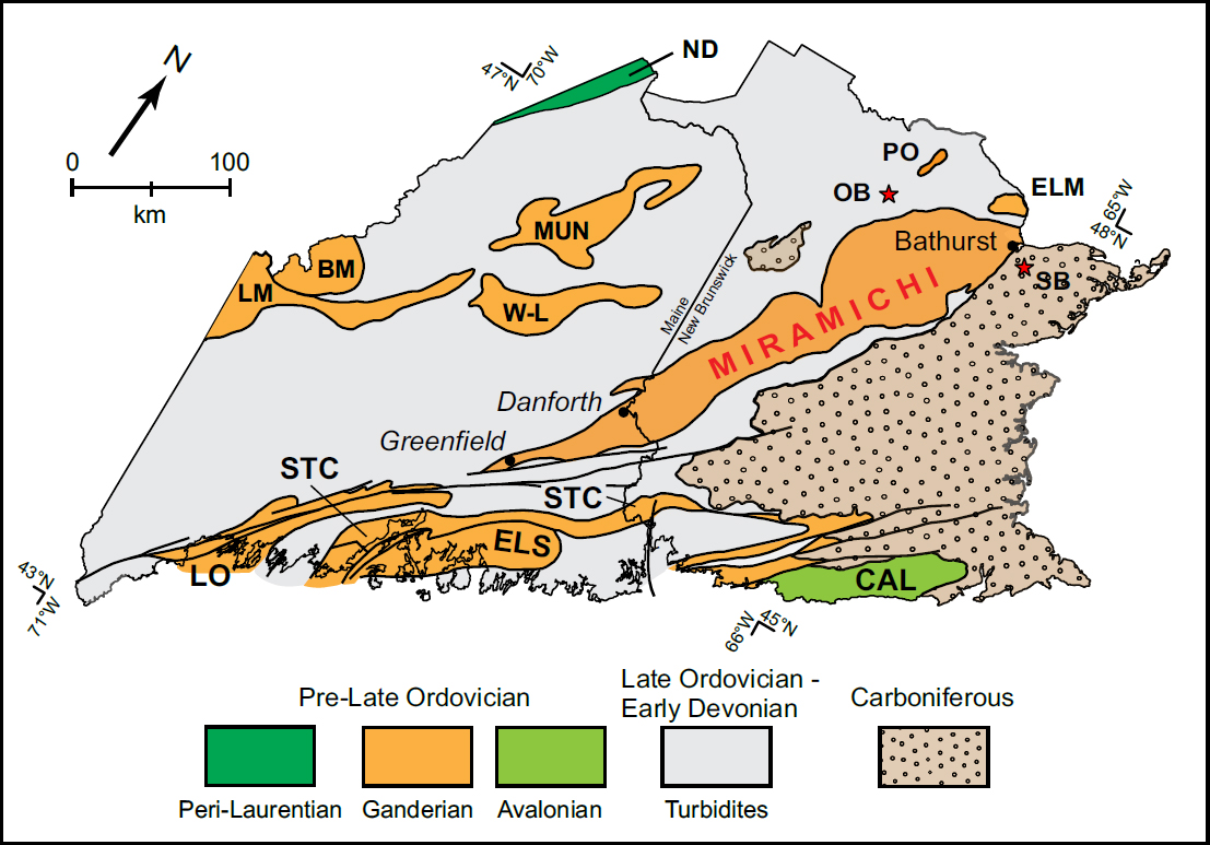
1 The Early Paleozoic tectonic evolution of the northern Appalachian orogen in Maine and New Brunswick is recorded in northeast-trending inliers of Late Cambrian to Middle Ordovician strata, separated today by broad bands of Late Ordovician to Early Devonian cover rocks (Fig. 1). The Miramichi terrane is the largest of these inliers, extending more than 250 km from Bathurst in northern New Brunswick to the Danforth area at the New Brunswick/ Maine border, after which it narrows rapidly and terminates about 100 km farther to the southwest, south of Greenfield (see Ludman 2020).
 Display large image of Figure 1
2 The youngest strata throughout the Miramichi terrane are thick sections of volcanic rock, most intensely studied in the Bathurst area where they host volcanogenic sulfide deposits (van Staal et al. 2003). The ages and chemistry of Miramichi volcanic rocks in New Brunswick reveal the timing of arc-related volcanism associated with the accretion of the Ganderian plate to ancestral North America (Winchester et al. 1992; Fyffe 2001; van Staal et al. 2016), but little information has been available about volcanic rocks in the Maine segment, making it impossible to investigate similarities or differences along the length of the terrane. This paper presents new and previously unpublished data on the chemical compositions and ages of Miramichi volcanic rocks in Maine that permit a more comprehensive view of Miramichi volcanism, its roles in Ganderian accretion, and its relationships to other pre-Silurian belts.
Tectonic setting
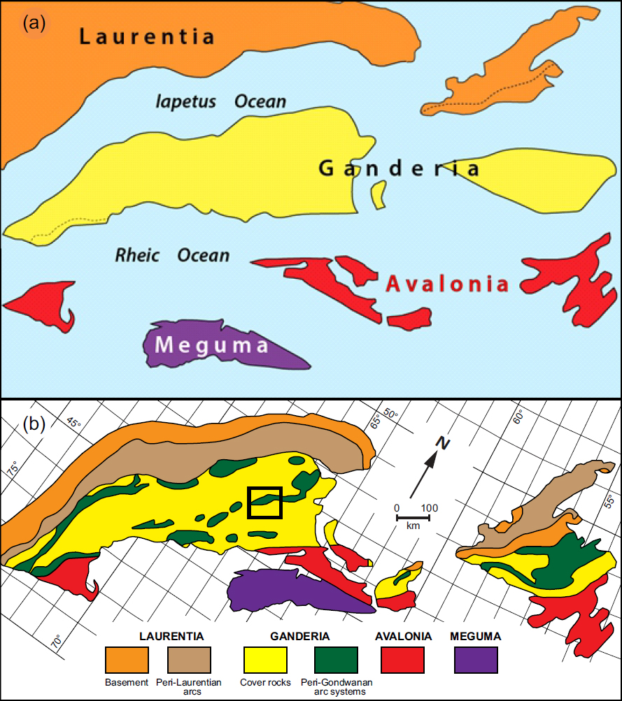
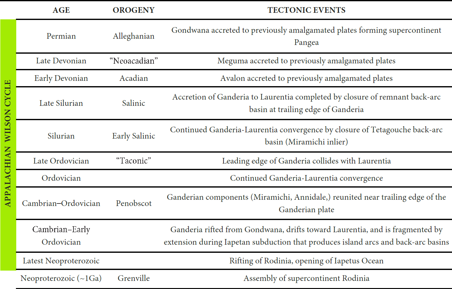
3 The Paleozoic evolution of the Appalachian orogen in New England and adjacent Atlantic Canada involved the progressive accretion to ancestral North America (Laurentia) of the outboard Gander, Avalon, and Meguma peri-Gondwanan plates (Fig. 2a), resulting in the current lithotectonic framework (Fig. 2b). Ganderia is the largest accreted plate (Fig. 2b), and studies of Ganderian volcanic units in the northern Miramichi, Elmtree, and Popelogan inliers in New Brunswick have yielded a detailed picture of subduction and associated opening and closing of back-arc basins in the central part of the plate (Table 1; van Staal et al. 2016). Previous tectonic models have focused on the nature and sequence of plate accretion events. This paper complements and helps evaluate those models, but also makes possible comparison of volcanism along the length of the Miramichi inlier.
 Display large image of Figure 2
 Display large image of Table 1
Geologic setting
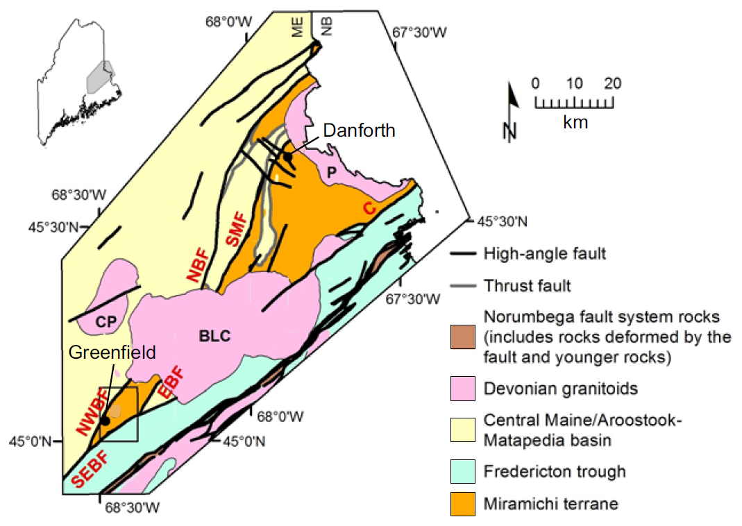
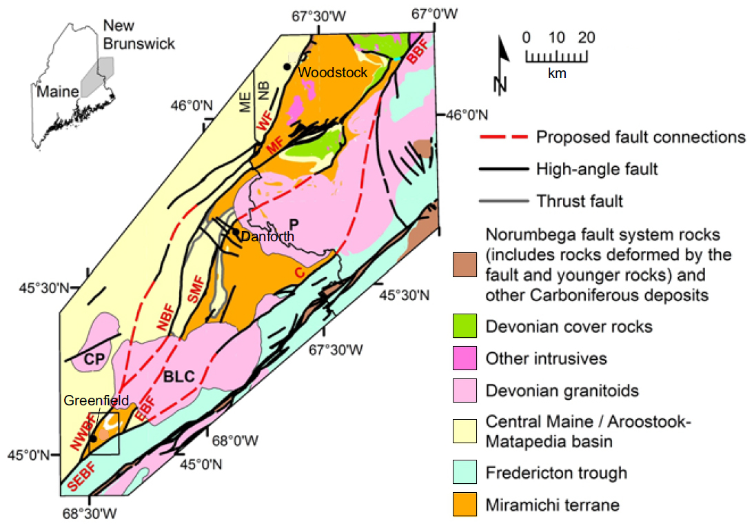
4 Figure 3 shows relationships of the Miramichi terrane with younger cover rocks of the Central Maine/Aroostook– Matapedia (CMAM) basin to the northwest and the Fredericton trough to the southeast. The Miramichi study area shown in Figure 3 has experienced only lower greenschist facies regional metamorphism (chlorite and sub-chlorite zones) and thus represents a supracrustal level of the northern Appalachians (Ludman 2020). Delicate primary features are generally well preserved, including shard outlines in Miramichi volcanic rocks described below.
 Display large image of Figure 3
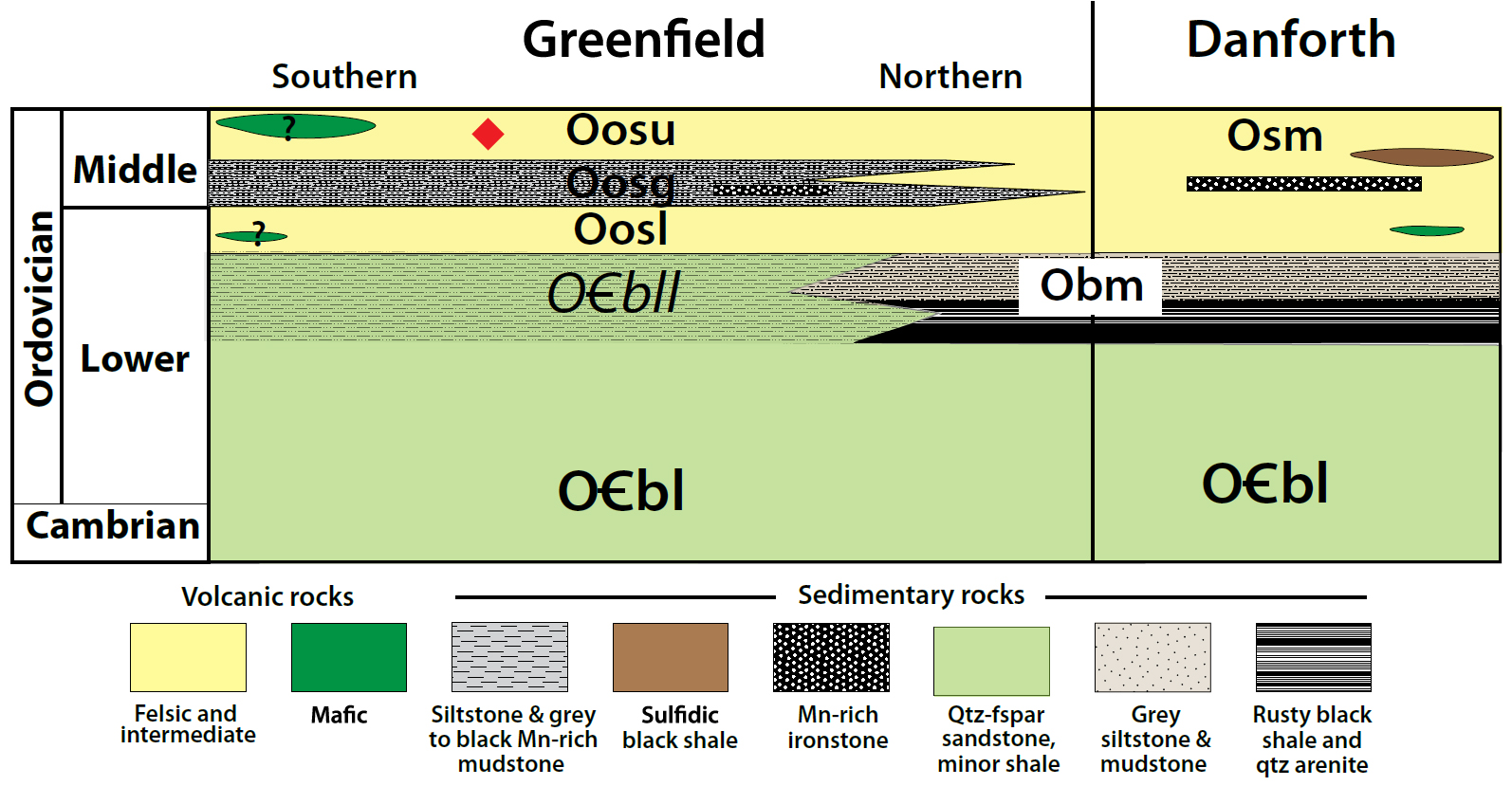
5 The Miramichi terrane in Maine is divided into two segments by the ca. 380 Ma Bottle Lake plutonic complex: the Danforth segment between the complex and the New Brunswick border, and the smaller Greenfield segment southwest of the complex (Fig. 3). The Pokiok igneous complex at the Maine–New Brunswick border further separates the Maine part of the inlier from the southwestern New Brunswick components.
6 Regional-scale faults separate the Miramichi terrane from adjacent cover rocks. The southeastern contact with the Fredericton trough is the Codyville fault in the Danforth segment, northwesternmost branch of the transcurrent Norumbega fault system, and the Southeast Boundary Fault, its possible continuation, in the Greenfield segment. The evolution of the western contact was complex, with the Northwest Boundary, Stetson Mountain, and North Bancroft faults locally separating Miramichi from CMAM strata. Evolution of these boundaries and their relationships with faults in New Brunswick is beyond the scope of this paper; for details see Ludman (in press).
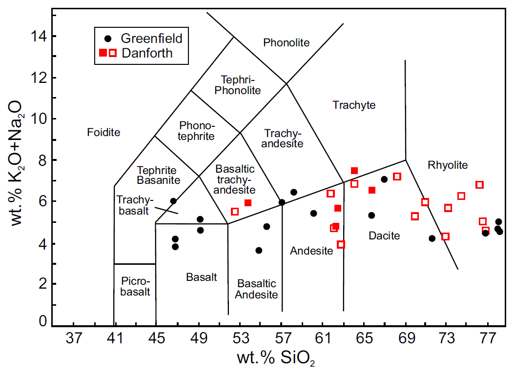
Previous studies of Miramichi volcanic rocks in Maine
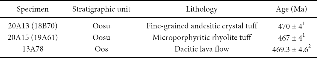
7 Despite its tectonic significance, the Miramichi terrane in Maine received little attention from previous investigators. The first modern report was a United States Geological Survey regional reconnaissance study of central eastern Maine that included the Danforth segment but did not extend as far southwest as the Greenfield area (Larrabee et al. 1965). That study briefly described volcanic rocks to which a Middle to Late Ordovician age was assigned based on graptolites in a black shale horizon just north of Danforth. It also suggested similarities with the Tetagouche volcanic section in northern New Brunswick and with rocks of the Weeksboro– Lunksoos Lake belt in northern Maine. Detailed mapping between 1980 and 2020 established and refined Danforth segment stratigraphy and interpreted a complex, multideformation tectonic history described below (Ludman 1985, 1991, 2003, 2020; Ludman and Berry 2003; Ludman and Hopeck 2020).
8 Sayres (1986) suggested an internal stratigraphy for Miramichi volcanic rocks in the Danforth 15′ quadrangle (see below) and reported chemical analyses revealing a calcalkaline suite of andesite, rhyodacite, and rhyolite that she interpreted as a volcanic arc assemblage (Sayres 1986). A study of the Meductic arc in southwestern New Brunswick included a few samples from the Danforth area, and supported Sayres’ tectonic interpretation (Winchester et al. 1992).
9 The Greenfield segment was first studied by Olson (1972) in the southwestern part of what is now the Greenfield 7½′ quadrangle. His Masters thesis described a thick volcanic section composed mostly of andesitic and rhyolitic pyroclastic rocks but provided no chemical data. He tentatively correlated the volcanic rocks with those in the Danforth area and with the Weeksboro–Lunksoos Lake section based on descriptions in Larrabee et al. (1965) and Neuman (1962), respectively. Greenfield segment stratigraphy has been revised and volcanic geochemistry reported in recent studies of the Greenfield 7½′ quadrangle (Ludman 2020, in press).
Stratigraphy of the Miramichi terrane in Maine
10 A well-defined stratigraphy in the Danforth segment is truncated by the Bottle Lake pluton, but its basal Baskahegan Lake and Bowers Mountain formations reappear at the northern margin of the Greenfield segment (Fig. 4). The Bowers Mountain is absent in the southern part of the Greenfield segment, where a unique, thin-bedded Lazy Ledges Road member of the Baskahegan Lake Formation passes upward into volcanic rocks of the Olamon Stream Formation.
 Display large image of Figure 4
11 Thick volcanic suites cap the Miramichi section in both segments and, although similar, are different enough to require separate names – the Stetson Mountain Formation in the Danforth segment, and the Olamon Stream Formation in the Greenfield area. The Olamon Stream interpretation presented here is a revision of a recent report (Ludman 2020).
12 Sayres (1986) divided the Stetson Mountain Formation into a thin basal member of cryptocrystalline to fine grained felsic and intermediate ashfall tuff and a much thicker upper member of coarser felsic and intermediate ashflow tuff and agglomerate, separated by a thin, medial member of chalky weathering, black sooty iron- and manganese-rich volcanogenic (?) mudstone. A similar sequence appears to occur in the Olamon Stream Formation although outcrop control of the lower member is very poor. The lower member comprises mostly cryptocrystalline tuff, separated by an anoxic mudstone/siltstone (Greenfield member) from the upper member which appears to contain more abundant coarser pyroclastic rocks. The most significant difference between the two segments is the presence of relatively coarse grained mafic volcanic (and subvolcanic?) rocks in the Greenfield segment. Unfortunately, the stratigraphic position of the mafic rocks within the Olamon Stream Formation is unknown.
MIRAMICHI VOLCANIC ROCKS IN MAINE
Rock types
13 The Danforth and Greenfield suites contain predominantly (>95%) pyroclastic rocks, a variety of intermingled intermediate (andesite, basaltic andesite) and felsic (dacite, rhyodacite, rhyolite) crystal, lithic, and crystal-lithic ashfall and ashflow tuffs, breccias, coarse agglomerates and subordinate lavas with rare volcaniclastic sedimentary horizons. Mafic rocks are largely confined to a small area at the southwest terminus of the Miramichi terrane, with sparse basaltic tuffs elsewhere in the Olamon Stream Formation. The most mafic rock in the Danforth segment is a low-silica basaltic andesite that occurs only as xenoliths in the Bottle Lake pluton and in a small fault-bounded sliver between that pluton and the Baskahegan Lake Formation.
Felsic and intermediate rocks
14 Volcanic rocks of the Olamon Stream and Stetson Mountain formations are divided into three lithofacies that will be described in order of their abundance: ashfall tuffs; ashflow tuffs, breccias, and agglomerates and lavas.
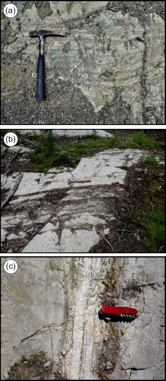
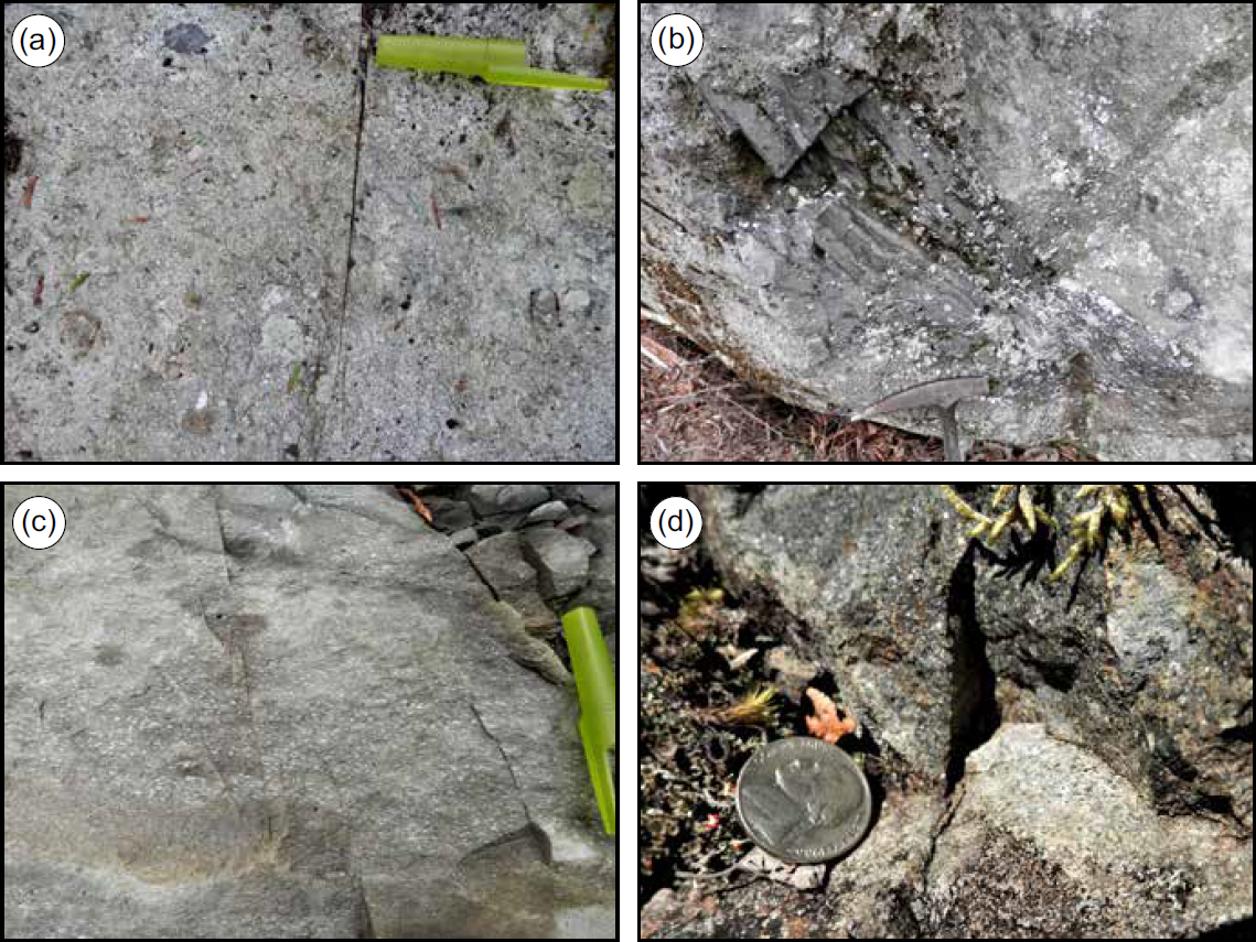
15 Ashfall tuffs: Cryptocrystalline, almost porcelaneous felsic and intermediate tuffs make up the lower member of the Stetson Mountain Formation and about half of the Olamon Stream Formation (aphanite in Olson 1972). Most have been devitrified and sericitized, and the presence of microphenocrysts and/or small lithic fragments distinguish crystal, lithic, and crystal-lithic varieties. Cryptocrystalline tuffs that occur in homogeneous, featureless layers and lack evidence of flow are interpreted as ashfall deposits formed during Plinian eruptions. They are light to medium grey on fresh surfaces but weather to chalky white (Fig. 5) and typically fracture conchoidally. Layers deposited during individual eruptive events range widely in thickness from a few centimetres (Fig. 6a) to at least two metres (Fig. 6b) but style and thickness commonly vary within as well as between outcrops (Fig. 6c).
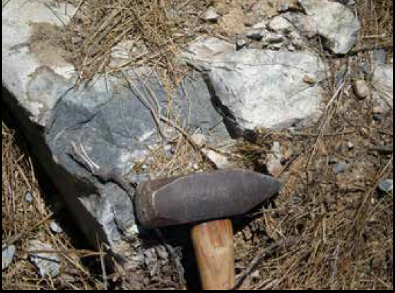 Display large image of Figure 5
 Display large image of Figure 6
16 Microporphyritic variants are common, with some phenocrysts barely detectable with a hand lens. Quartz and feldspar microphenocrysts (0.2–0.5 mm) occur in rhyolites and rhyodacites, along with plagioclase and pyroxene (up to 2.5 mm) in andesites. Some small lithic fragments are also present.
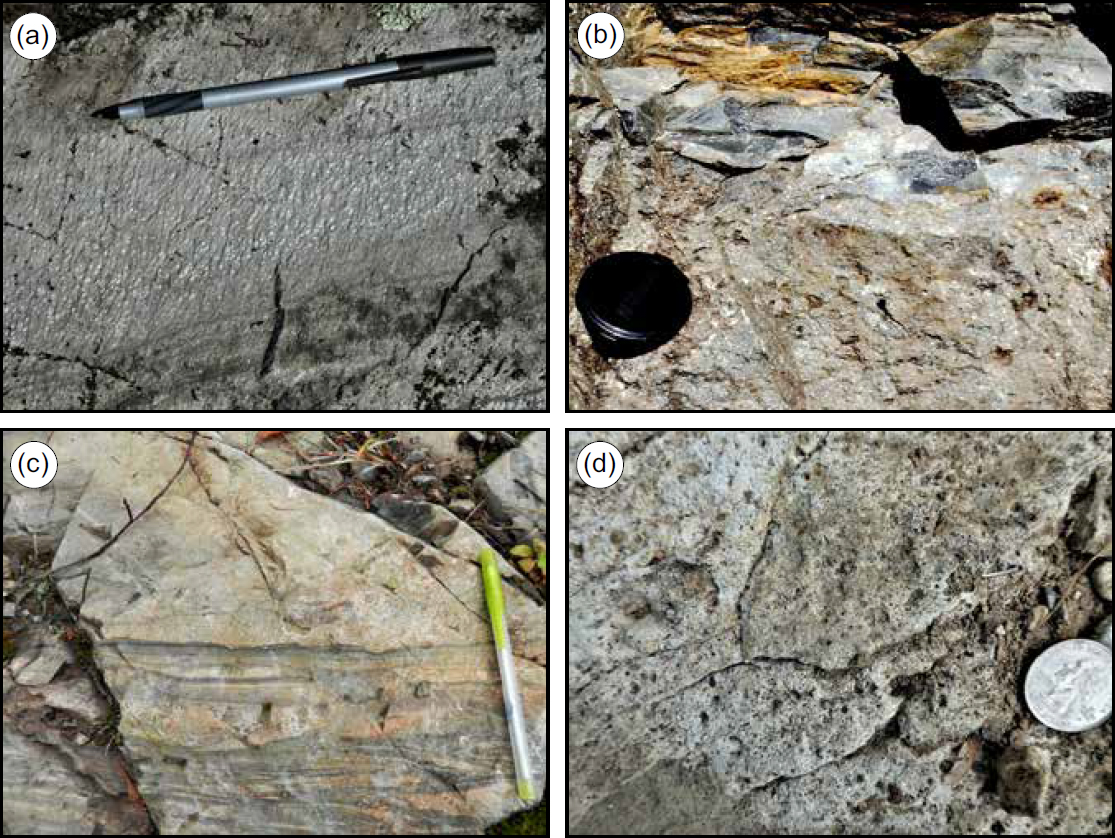
17 Textural variations within layers formed in single eruptive events reflect changes in flow regime (Fig. 7). The most common variation is in grain size, with systematic changes (Figs. 7a, b) or fluctuations (Fig. 7c). In most cases, the changes are not useful as facing indicators, unless paired with geopetal indicators like the load cast in Figure 7c. In rare instances, the upper part of eruptive units is scoriaceous (Fig. 7d).
 Display large image of Figure 7
18 Ashflow tuffs, volcanic breccias, agglomerates, and lavas: Most felsic and intermediate volcanic rocks in the Danforth segment (Sayres 1986) and approximately 40% in the Greenfield segment are volcanic breccias (Fig. 8a) and agglomerates with endogenous and exotic fragments (10 cm to 1 m in size) (Fig. 8b). Rare, imbricated fragments and foliation in coarse-grained and porphyritic lithic, crystal, or lithic-crystal tuffs (Fig. 8c) suggest eruption as ash and debris flows. Lava flows with microscopic to visible phenocrysts (Fig. 8d) are less common but are found throughout the volcanic suites in both segments.
 Display large image of Figure 8
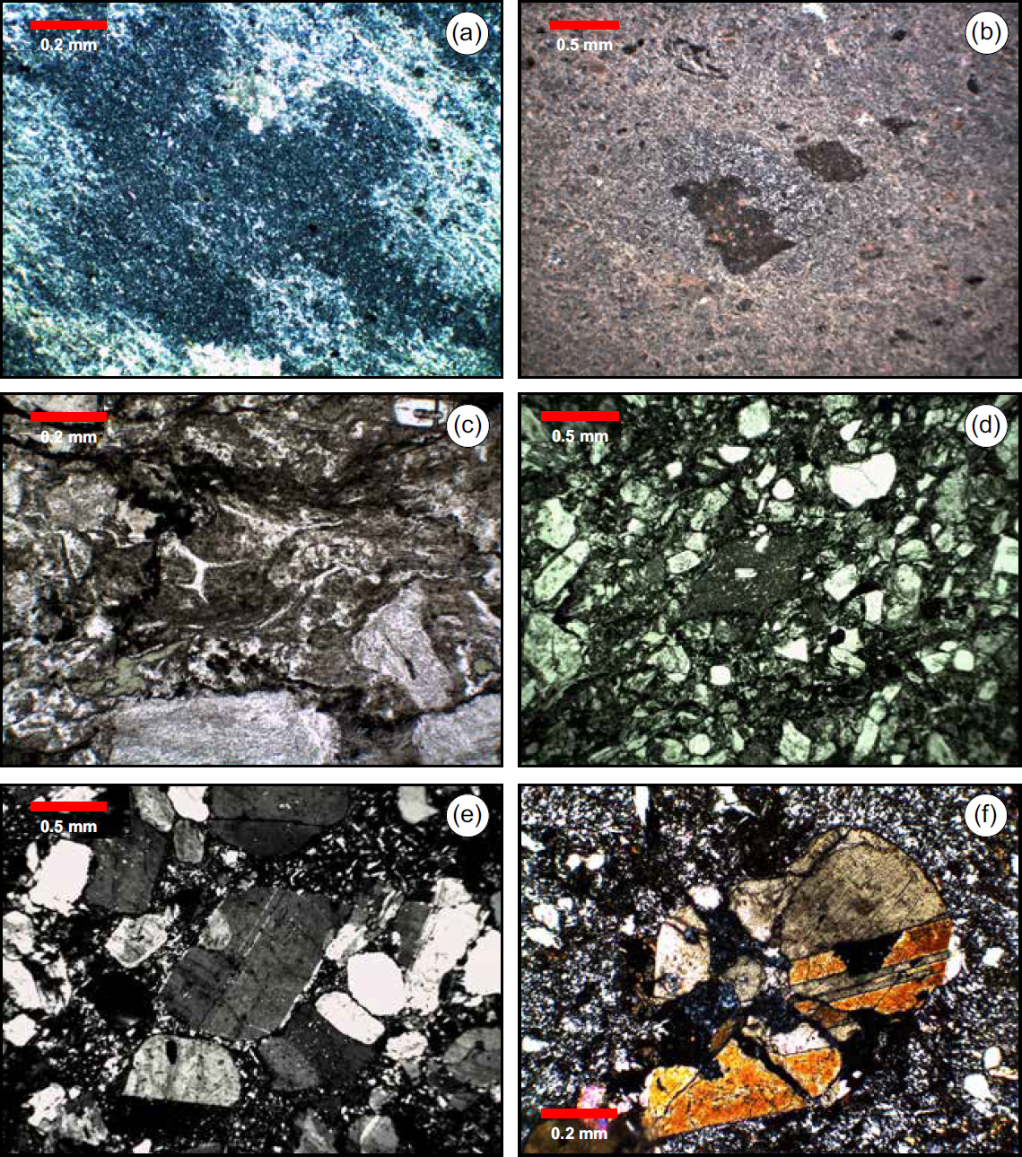
19 Photomicrographs in Figure 9 illustrate the variety of felsic and intermediate textures. Matrix differences visible in thin section distinguish felsic and intermediate rocks and lava flows from tuffs. The matrix of most of the pyroclastic rocks has devitrified to a sericitized cryptocrystalline mosaic composed of quartz, feldspar, and rare chlorite in rhyolites and dacites (Fig. 9a, b), with less quartz and more abundant coarse patches of chlorite in andesites. Despite devitrification and sericitization, shard outlines are preserved in a few samples (Fig. 9c). Rocks with an interlocking matrix of feldspar ± quartz crystals are interpreted as lava flows. In most instances they have phenocrysts readily visible to the naked eye (Fig. 9e, f).
 Display large image of Figure 9
20 Feldspar microphenocrysts in rhyolitic tuffs are typically subhedral to euhedral whereas quartz occurs as subhedral to anhedral grains partly resorbed by the matrix mosaic. Plagioclase phenocrysts in rhyolite and rhyodacite are generally only slightly altered, but in andesites are heavily sericitized and may contain abundant carbonate, particularly in their cores. Hornblende phenocrysts in andesites are typically subhedral and twinned (Fig. 9f) and have been altered to chlorite ± epidote in some thin sections.
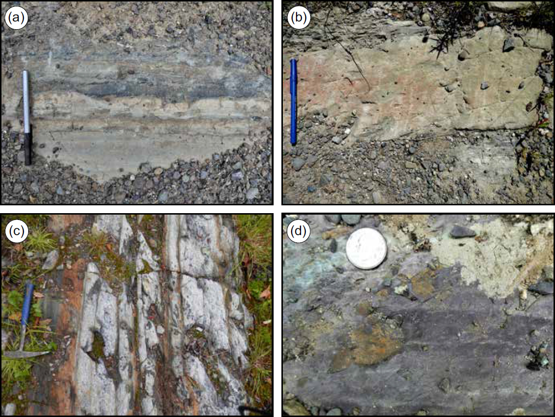
21 Sedimentary rocks: Horizons and individual beds of sedimentary rock make up a small percentage of the Olamon Stream and Stetson Mountain formations. Most are volcanogenic sandstone and coarse siltstone with subordinate grey pelite that can be difficult to recognize in the field because, like the volcanic rocks with which they are associated, they typically occur in thick, massive beds, weather chalky white and have a greenish cast caused by abundant detrital chlorite (Figs. 10a, b). They are distinguished in thin section by their detrital matrix rather than the interlocking or chloritized volcanic matrix of the pyroclastic rocks and lavas. Lenses and individual beds of black shale occur throughout the Olamon Stream and Stetson Mountain formations (Fig. 10c), and a unique horizon of maroon sandstone, siltstone, and shale crops out in the Greenfield quadrangle (Fig. 10d).
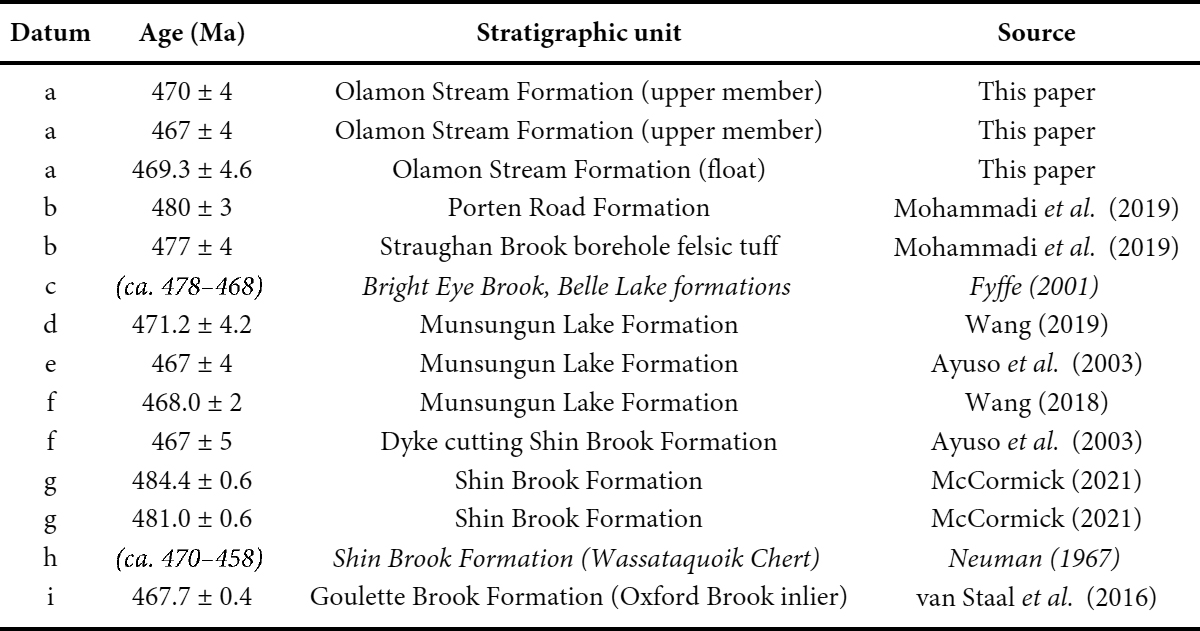
 Display large image of Figure 10
Mafic rocks
22 Basaltic lavas, ashflow tuffs, and volcanic agglomerates are minor constituents of the Greenfield segment and are mapped as a separate member of the Olamon Stream Formation (Ludman 2020, in press). Most are concentrated at the southwesternmost part of the Miramichi terrane just south of the Greenfield quadrangle, at the confluence of the Northwest and Southeast boundary faults. The contact between the mafic member and the main body of the Olamon Stream Formation is not exposed and their age relationships are unknown.
23 Basaltic tuffs also occur as individual layers within the Olamon Stream Formation, interbedded with andesite and dacite, but it is difficult to estimate their abundance because they are the same color (medium grey fresh surface, light grey to white weathered surfaces) and have the same fine to very fine-grained texture as the other rocks. Indeed, their presence was not suspected in the field and was revealed only by chemical analysis.
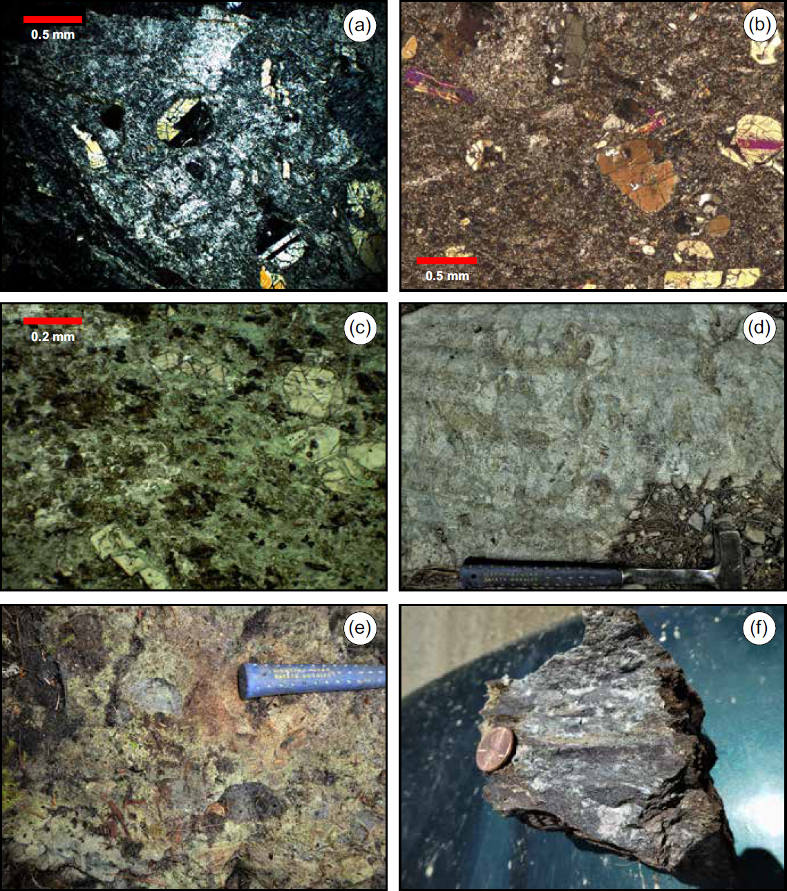
24 Two types of mafic rocks occur in the isolated terrane termination area, in roughly equal amounts – dark grey to greenish-grey, medium-grained basalt and greenstone, and coarse volcanic agglomerate. The former has seriate or porphyritic texture (Fig. 11a, b, c) and most occur in massive, nubbly weathering, featureless outcrops in which it is diffi-cult to identify primary layering. Matrix and pyroxene phenocrysts are typically less altered than plagioclase in some (Fig. 11a) but highly chloritized in others (Fig. 11b). These rocks are interpreted as lavas but in the absence of primary layering, may be subvolcanic intrusions.
 Display large image of Figure 11
25 About half are agglomerate with clasts up to 40 cm set in a green, fine-grained, chlorite-rich, matrix. Most agglomerate exposures are massive, but a primary flow foliation has been observed locally. A few agglomerates contain only endogenous fragments (Fig. 11d) and are possibly autobreccias, but most contain both endogenous and exotic fragments – most commonly andesite or more felsic volcanic rock (Fig. 11e). A unique outcrop contains a mixture of mafic ashflow tuff, dark red baked mudstone, and large, irregular patches of calcite (Fig. 11f). This is interpreted as a peperite, a sub-aqueous ashflow combining ash and unlithified sediment.
COMPOSITION OF MAINE MIRAMICHI VOLCANIC ROCKS
Analytical methods
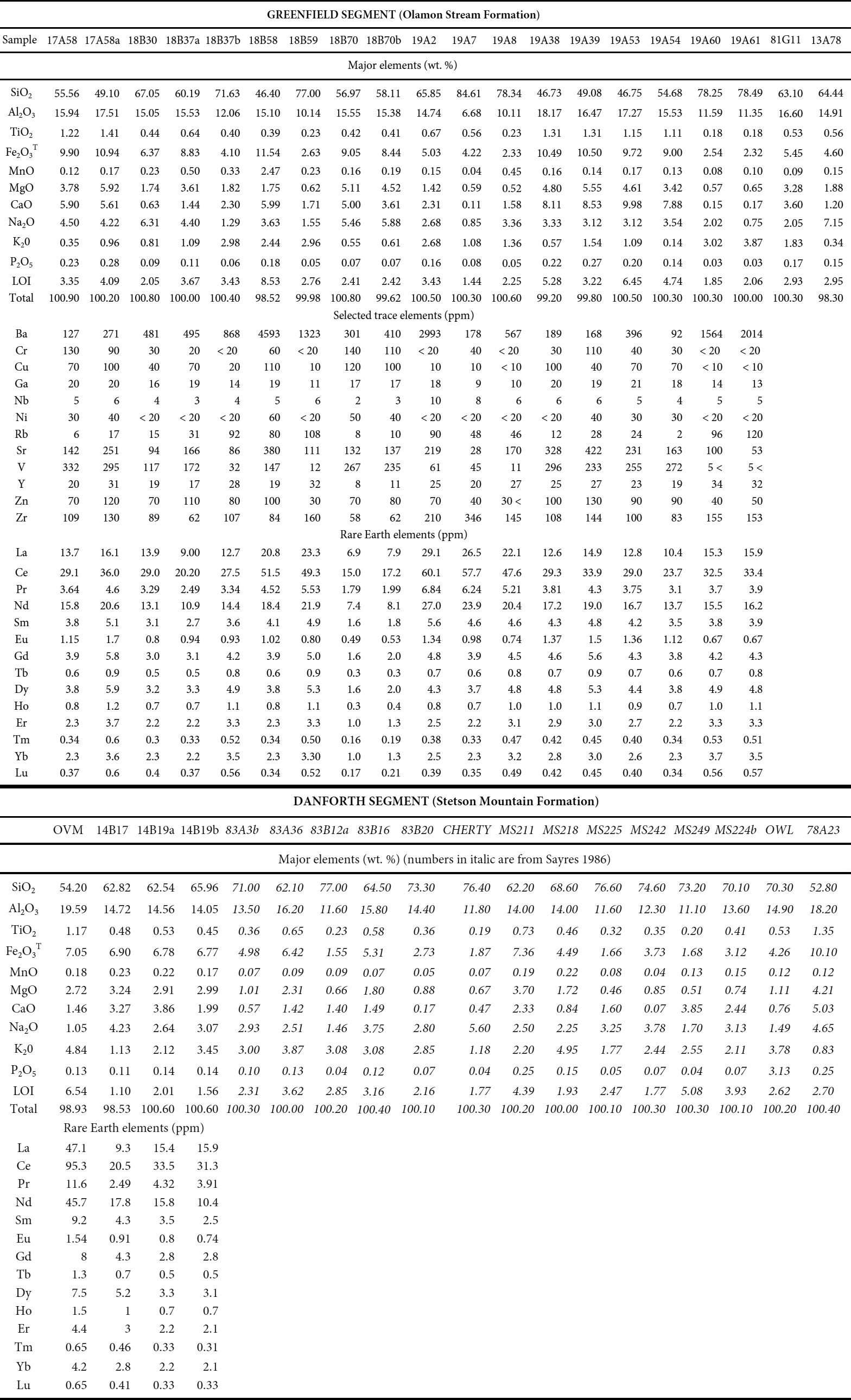
26 Seventeen samples of Olamon Stream volcanic rocks were collected in 2019 and sent to Activation Laboratories Ltd. in Ancaster, Ontario, for preparation and analysis of major elements by induction coupled plasma optical emission spectroscopy, and trace elements by induction coupled plasma mass spectrometry. Fifteen samples of least altered volcanic rocks from the Danforth segment had been collected by Sayres (1986), prepared at Queens College, and analyzed at X-ray Assay Laboratories Ltd (Don Mills, Ontario) by X-ray fluorescence. Five additional samples from the Danforth segment were also processed by Activation Labs in 2014.
Results
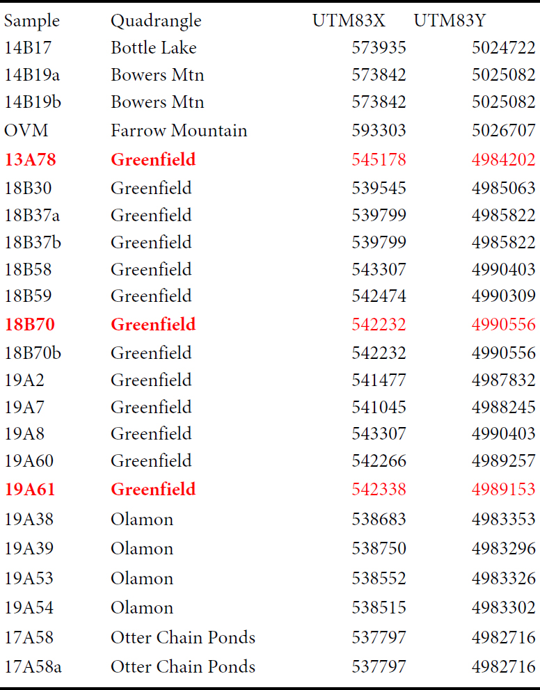
27 Thirty-eight samples were selected for major element geochemistry from the volcanic rocks in the Greenfield and Danforth segments of which 18 contain trace element compositions and 22 have rare earth element compositions (Appendix A). For samples collected in this study the Universal Transverse Mercator (UTM) locations are recorded in Appendix B. Locations for previous samples collected from the Danforth segment are recorded in Sayres (1986). Volcanic rock types range from basalt to basaltic andesite, andesite, dacite, and rhyolite (Fig. 12), mirroring the textural variety shown in Figures 9, 10, and 11. Overall, rocks in the two segments exhibit similar compositions and proportions although, as mentioned earlier, mafic rocks present in the Olamon Stream Formation are absent from the Stetson Mountain Formation. At this time, several explanations are plausible for this difference: different eruptive histories at different volcanic centers; different erosional levels in the two segments (although the bases of both can be observed, the top of neither is exposed); and structural complexities.
 Display large image of Figure 12
28 Sayres (1986) interpreted an internal stratigraphic sequence based on texture and eruptive style in the Danforth segment in an area with excellent outcrop control. However, no systematic compositional trend is apparent in the Stetson Mountain Formation, as andesite, dacite, and rhyolite are found in similar abundance in the lower and upper parts of the formation, commonly in the same outcrop. Similar combinations of intermediate and felsic rocks at individual outcrops are also common in the Olamon Stream Formation (e.g., Appendix A, samples 18B37a, b).
AGE OF MIRAMICHI VOLCANIC ROCKS IN MAINE
Analytical methods
29 Nine representative Miramichi volcanic rocks were collected for U–Pb dating in the summer of 2019, three each from the mafic member and main body of the Olamon Stream Formation, and three from the Stetson Mountain Formation. These samples were sent to Overburden Drilling Management, Ltd., Ottawa, Canada, for electric pulse disaggregation and initial zircon separation. Further separation and hand picking were carried out at the University of New Brunswick geochronology laboratory in Fredericton, New Brunswick, Canada.
30 U–Pb analyses were conducted at the University of New Brunswick using an ASI M-50 193 nm excimer laser ablation system (Complex Pro 110) with a 20 ns pulse width. The ablation system is equipped with a Laurin Technic Pty S–155 two–volume ablation cell coupled, using 4mm OD Nylon tubing, to an Agilent 7700× quadrupole ICP-MS equipped with dual external rotary pumps. Ablated material was transported to the ICP-MS using a mixed He (300 mL/ min) and Ar (930 mL/min) carrier gas. Sensitivity was enhanced using the second external rotary pump and adding N2 (2.0 mL/min) downstream of the cell. Due to isobaric interference of 204Pb with 204Hg impurities within the carrier gas, direct measurement of the 204Pb signal was permitted by using in-line high-capacity Vici Metronics Hg traps on all gas lines ensuring that 204Hg remains <150 cps under maximum sensitivity conditions. Correction of the 204Hg interference on 204Pb was then performed via peak–stripping using the measured 202Hg on the gas background and assuming a canonical value for 202Hg/204Hg.
31 Analyses of all unknowns were bracketed with at least 16 spots on primary reference material to monitor and correct for instrument drift and time-dependent down-hole fractionation. For zircon, FC-1 (ca. 1099 Ma; Paces and Miller 1993) was used as primary external standard and accuracy was checked using Plesovice (ca. 337 Ma; Sláma et al. 2008 ) or GSC z1242 (ca. 2679 Ma; B. Davis personal communication 2021) A 17 µm crater size, 3 J/cm2 laser energy, and a repetition rate of 4 Hz were used for all unknowns and standards. 90Zr was used as a guide mass for ablations and internal standardization using an estimated value of 47 wt% Zr. NIST 610 was used for instrument tuning and as a concentration standard. Drift was modeled using Iolite3.7TM automatic fit function whereas down-hole fractionation was modeled using the automatic exponential fit option. The net 204Pb (cps) signal was used for common Pb corrections (if required) for zircon and incorporated into the VizualAge U–Pb data reduction scheme (DRS) (Petrus and Kamber 2012) operating under Iolite3.7TM. The routine uses an age estimate based on the measured 206Pb/238U and common Pb ratios based on the evolution curves of Kramers and Tolstikhin (1997). Common Pb corrections were applied only to zircon analyses with net 204Pb >50 cps and 1σ internal errors <30%. All other data remained uncorrected.
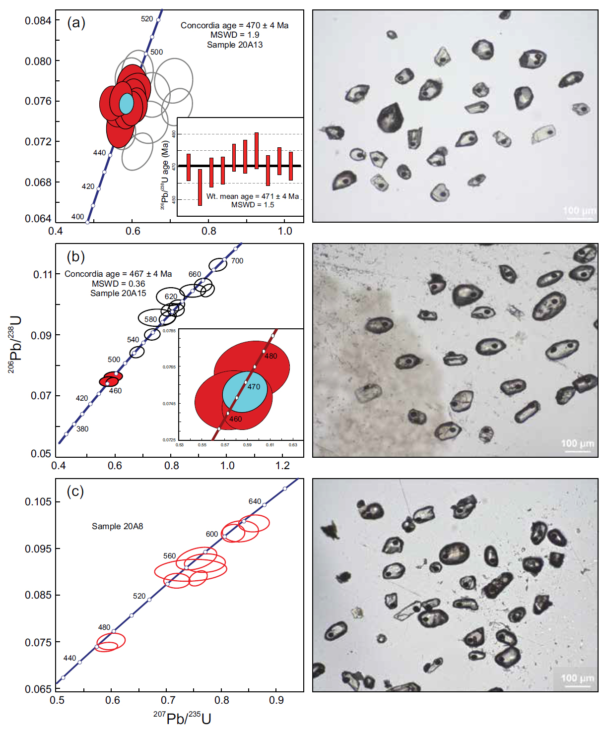
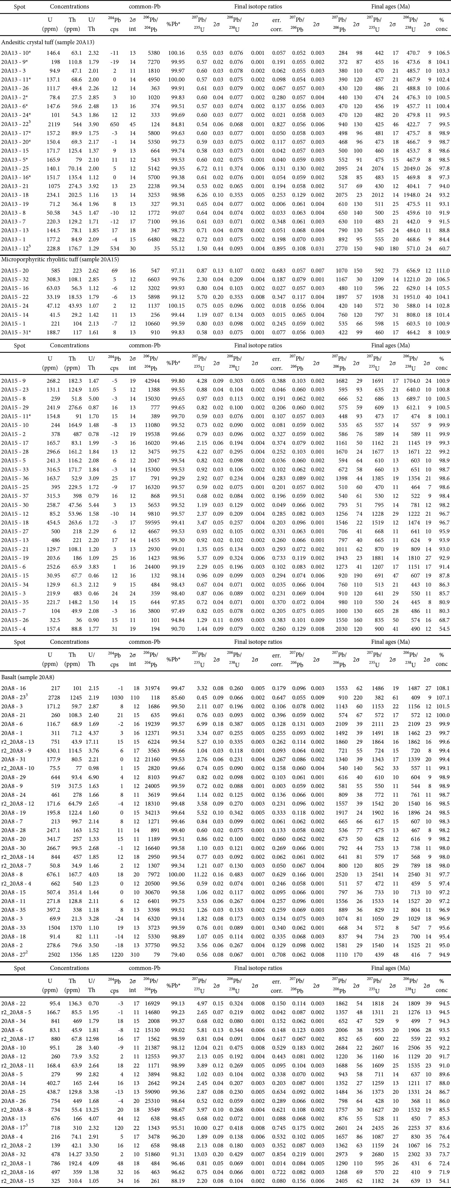
32 Three volcanic rocks from the Olamon Stream Formation upper member yielded enough zircon grains for valid dating (Table 2). They include only two of the nine collected in 2019, dated by LA-ICPMS, and one dated earlier by U–Pb SHRIMP (Ludman et al. 2018). Concordia diagrams and images of zircons from the two new ages are shown in Figures 13 a and b. The UTM locations and the complete analytical data for the new dates are given in Appendix B and C. Unfortunately, none of the Danforth segment samples could be dated and the age of the Olamon Stream basalts is still uncertain.
 Display large image of Table 2
33 The three ages are essentially identical, indicating eruption of the upper member of the Olamon Stream Formation at about 469 Ma, the boundary between the Lower and Middle Ordovician series (Floian–Dapingian stages). Unfortunately, they offer no insight into the timing of initial volcanism or the internal stratigraphy of the formation.
34 Attempts to date Olamon Stream basalts were inconclusive. Only one sample(20A8) had enough zircon grains to be dated, and most of these grains yielded a range of inheritance ages (Fig. 13c). Two zircon analyses close to Concordia suggest an age similar to those of the dated samples but are not conclusive.
 Display large image of Figure 13
DISCUSSION
35 Field, geochemical, and geochronologic data permit interpretation of the tectonic setting of Miramichi volcanic rocks in Maine, their correlation with volcanic units from both New Brunswick and other Cambrian–Ordovician Ganderian inliers in Maine, and a test of proposed tectonic models.
Tectonic setting
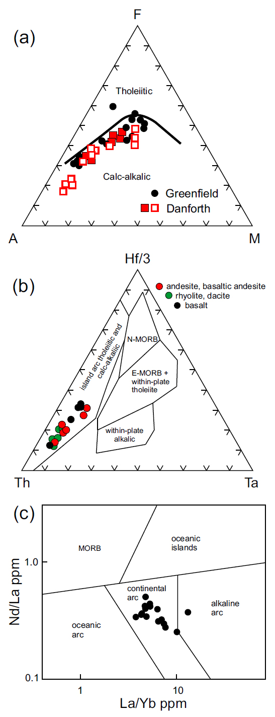
36 Miramichi volcanic rocks in Maine are a classic calcalkaline basalt-andesite-rhyolite suite (Fig. 14a), associated with a subduction-related volcanic arc (Fig. 14b), consistent with previous interpretations of Miramichi volcanism (e.g., Sayres 1986; Winchester et al. 1992; van Staal et al. 2016). Niobium, lanthanum, and ytterbium data further suggest eruption in an ensialic continental arc rather than an oceanic setting (Fig. 14c). Lava flows, ashfall and ashflow tuffs, and volcanic agglomerates indicate recurrent Plinian and phreatomagmatic eruptions consistent with this environment.
 Display large image of Figure 14
Correlation of Miramichi volcanic rocks in Maine
37 Stratigraphic, lithologic, chemical, and geochronological data presented above permit correlation of the Olamon Stream and Stetson Mountain formations with volcanic rocks of the Miramichi inlier in New Brunswick and the Weeksboro–Lunksoos Lake and Munsungun Cambrian– Ordovician inliers in northern Maine. Direct connections are not possible with northern Maine inliers because of the extensive cover rocks, nor with the New Brunswick Miramichi volcanic rocks because the Pokiok plutonic suite at the New Brunswick–Maine border separates the Danforth segment from potential correlatives in west-central New Brunswick.
38 Structural complexities also obscure Maine–New Brunswick correlation. The Miramichi inlier is separated everywhere from adjacent Late Ordovician to Late Silurian strata by regional-scale boundary faults and is cut into discrete blocks by internal faults that had complex thrust, high-angle dip-slip, and strike-slip episodes (Fig. 15; Ludman in press). The Bottle Lake and Pokiok complexes also interrupt continuity of these faults, adding another element of uncertainty to correlations. Indeed, depending on how the faults are connected through the Pokiok plutonic suite, otherwise strong candidates for correlation may lie in different fault blocks.
39 Thus, although areas of Early to Middle Ordovician Miramichi volcanic rocks in Maine and New Brunswick are parallel to the fault-controlled trend of the terrane, their component rocks may not actually be on strike with one another. Figure 15 shows one of several possible connections of Miramichi faults in Maine and New Brunswick. This model was chosen so that the Greenfield and Danforth segments are within the same fault block, but as a result, the Meductic Group in the Eel River are lies on another.
 Display large image of Figure 15
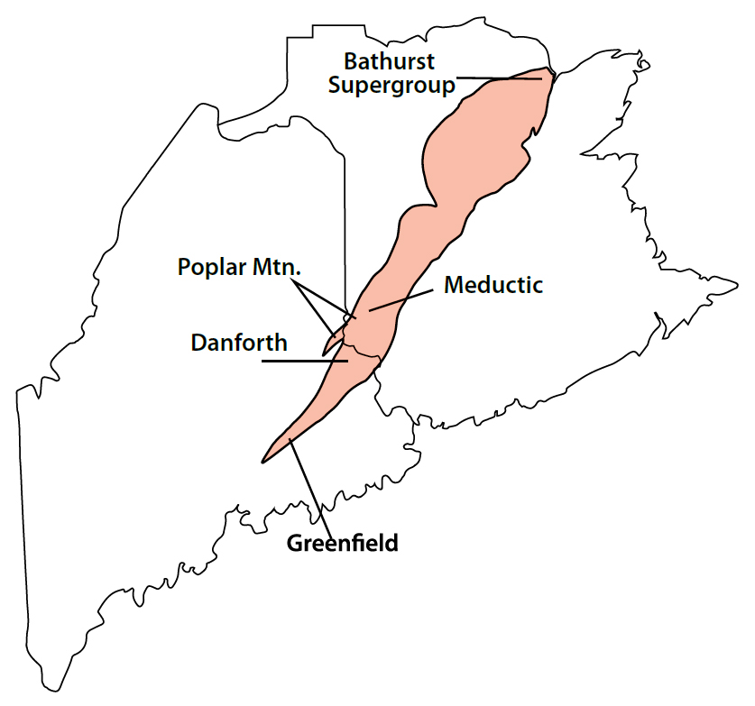
New Brunswick correlations
40 The most likely Stetson Mountain and Olamon Stream correlatives in New Brunswick include volcanic rocks of the Bathurst Supergroup in northern New Brunswick, the Meductic Group in west-central New Brunswick, and the Poplar Mountain volcanic complex that spans the New Brunswick–Maine border just north of Danforth (Fig. 16; Chi and Watters 2002).
 Display large image of Figure 16
41 The Bathurst Supergroup comprises volcanic and sedimentary rocks of the Tetagouche, Sheephouse Brook, and California Lake groups that occur in three stacked nappes of the Bathurst subduction complex (van Staal et al. 2016). Although ages of basal volcanic units in these groups overlap partially with those of the Olamon Stream Formation they are not considered correlative because they have within-plate signatures and are interpreted to have erupted in a back-arc environment associated with the Popelogan arc rather than the arc itself (e.g., van Staal et al. 2016; see below). In addition, most of its rocks are significantly younger than the dated Olamon Stream Formation samples.
42 The Poplar Mountain volcanic complex is geographically closest to the Stetson Mountain Formation, separated by a terrane-bounding fault from the Danforth segment only a few miles north of Danforth. At ca. 359 Ma (Chi et al. 2008), it is also significantly younger (10 myr) than the dated Olamon Stream Formation and its bimodal basalt–rhyolite suite suggests a back-arc rather than arc environment. We suggest that the Poplar Mountain volcanic rocks more likely correlate with interbedded rhyolite and basalt in the upper part of the Bathurst Supergroup (Sullivan and van Staal 1996).
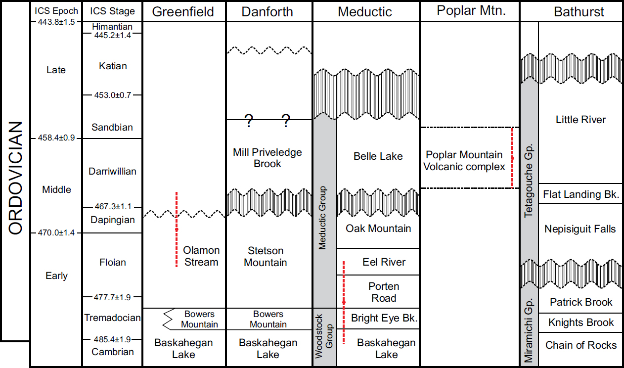
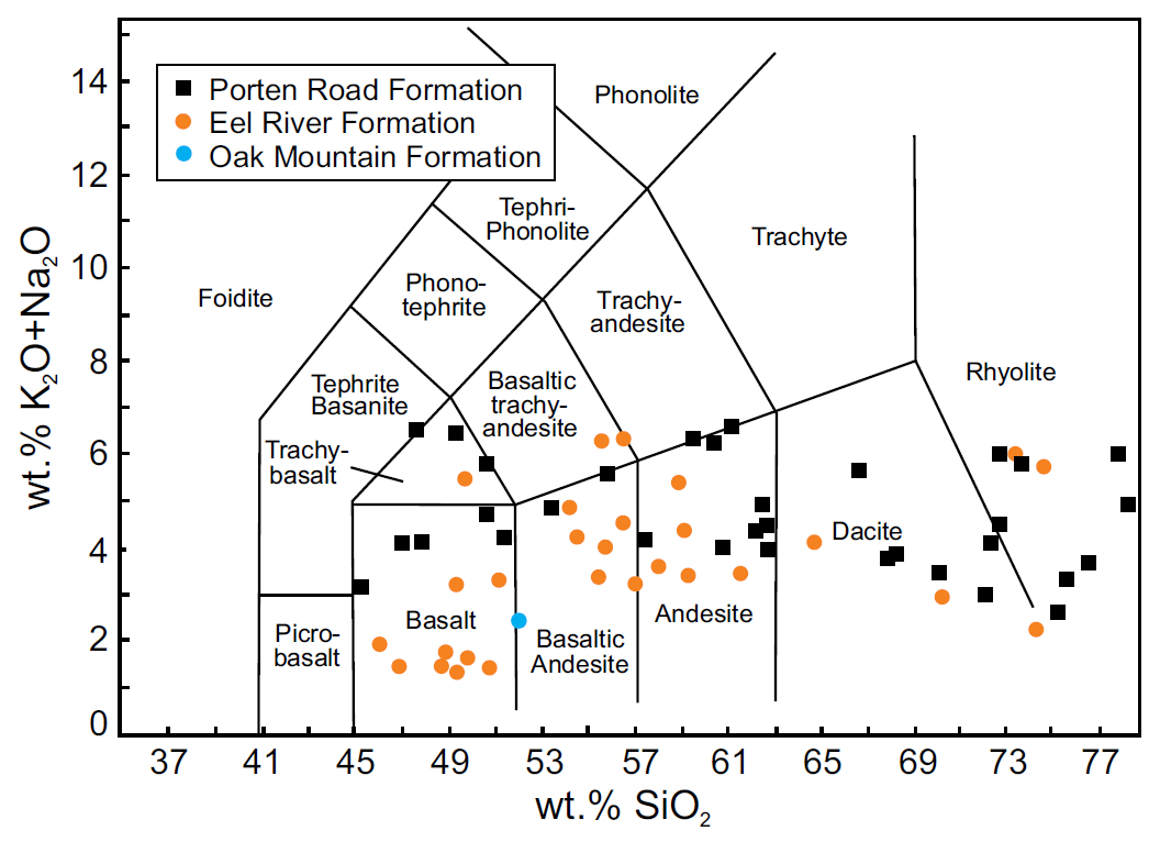
43 Meductic Group correlation: Several previous workers (e.g., Fyffe 2001; Winchester et al. 1992; Ludman 2003; van Staal et al. 2016) have correlated the Stetson Mountain Formation (and by inference the Olamon Stream Formation) with volcanic rocks of the Meductic Group in the Eel River area of west-central New Brunswick (Fig. 15). Their common location at the western margin of the Miramichi terrane, comparable stratigraphic positions (Fig. 17), compositions (Fig. 18), and interpreted tectonic settings provide compelling evidence for this correlation:
 Display large image of Figure 17
 Display large image of Figure 18
44 Stratigraphic position: Maine Miramichi and Meductic Group volcanic rocks erupted conformably on very similar substrates and are overlain unconformably by similar sedimentary rocks (Fig. 17). The oldest Miramichi unit in Maine is the Cambrian–Ordovician Baskahegan Lake Formation, (Ludman 1991, 2003), a distinctive sequence of quartzose and quartzofeldspathic sandstone with subordinate pelitic rocks. It is overlain conformably by quartzose sandstone and anoxic black shale of the Bowers Mountain Formation, and that, in turn, by the Olamon Stream and Stetson Mountain formations. The substrate in the Eel River area is the Woodstock Group, containing the Baskahegan Lake Formation, conformably and gradationally overlain by anoxic shale and sandstone of the Bright Eye Brook Formation, and then, conformably and gradationally, by the Porten Road Formation, the oldest volcanic unit in the Meductic Group (Fyffe 2001; McClenaghan et al. 2006).
45 Rocks interpreted to lie unconformably above the two volcanic suites (Fig. 17) are also similar to one another. The Belle Lake Formation in New Brunswick (Fyffe 2001) and the Mill Priveledge Brook Formation in Maine are nearly identical, both consisting of sandstone interbedded with black shale and siltstone.
46 Similar substrate-volcanic relationships occur in the Bathurst Supergroup in northern New Brunswick, but with an important difference. Unlike the conformable sequences in the Eel River, Danforth, and Greenfield areas, a widespread unconformity attributed to the Penobscot orogeny separates, for example, the Miramichi Group substrate [Chain of Rocks (≈ Baskahegan Lake) + Knights Brook and Patrick Brook (≈ Bowers Mountain/Bright Eye Brook)] from volcanic and sedimentary rocks of the Tetagouche Group. The significance of this difference is discussed below.
47 Composition: The basalt-basaltic andesite-dacite-rhyolite suite in the Stetson Mountain and Olamon Stream formations is mirrored by the Meductic Group (compare Figures 18 and 12), but lithologic proportions are different and a well-defined temporal increase in mafic volcanism from the Porten Road to the Oak Mountain Formation is not recognized in Maine, although internal stratigraphy is less well established there. Based on the area, basalt is the most abundant lithology in the Eel River area (McClenaghan et al. 2006) and occur in all three Meductic Group volcanic formations but are absent from the Danforth segment and are a very minor component of the Greenfield segment, as discussed above.
48 Tectonic setting: Both the Meductic Group (Winchester et al. 1992; McClenaghan et al. 2006) and Maine Miramichi volcanic suites are calc-alkaline. Common siliciclastic substrates and trace element discrimination diagrams further attribute volcanism in both suites to subduction-related continental arcs.
49 Age: Early Ordovician graptolites in the underlying Bright Eye Brook and Middle Ordovician graptolites in the overlying Belle Lake formations constrain the Meductic Group volcanic rocks to the late Early Ordovician to Early Middle Ordovician (Fyffe 2001; R. Wilson, personal communication 2021). This corresponds to a span of ca. 477–458 Ma (Cohen et al 2013, updated 2021), that is compatible with the ca. 469 Ma age of the upper member of the Olamon Stream Formation but does not indicate correlation with any of the three Meductic Group volcanic units.
50 Equivalence of the Olamon Stream, Stetson Mountain, and Porten Road formations is suggested by their positions as the oldest volcanic units conformably overlying similar pre-volcanic substrates, and supported by the restriction of rhyolite, abundant in Maine, solely to the Porten Road Formation in the Meductic Group. However, detailed examination of the ages and geochemistry of the formations reveals inconsistencies that suggest another possibility.
51 For example, the dated Porten Road dacite (480 ± 3 Ma; Mohammadi et al. 2019) is 11 myr older than dated Olamon Stream rhyolite, dacite, and andesite (ca. 469 ± 4 Ma). It is important to note that the dated Olamon Stream Formation rocks are from its upper member, whereas the Porten Road age is from near the base of the formation and thus closest to the underlying Bright Eye Brook Formation. The age of the Olamon Stream lower member, stratigraphically comparable to the dated Porten Road sample, is unknown.
52 Porten Road volcanism could conceivably have spanned 11 myr, but in that case the progressive upward increase in mafic rocks in the formation would be expected to occur in the Olamon Stream Formation as well. L.R. Fyffe (personal communication 2021) reported that Olamon Stream andesites described above are more like those of the Eel River Formation than those of the Porten Road Formation, implying at least partial correlation with younger parts of the Meductic Group.
53 Comparison of the Olamon Stream and Stetson Mountain formations with the three Meductic group volcanic units reveals other inconsistencies. Lithologically, neither black shales abundant near the base of the Porten Road Formation nor polylithic debris flows reported in Porten Road and Eel River cores (McClenaghan et al. 2006) are observed in the Olamon Stream Formation. Chemically, Porten Road rhyolites have, on average, lower TiO2, Fe2O3, Na2O and P2O5 and higher Al2O3, MgO, and CaO than those of the Olamon Stream and Stetson Mountain formations. In addition, Porten Road rhyolite and dacite samples have different rare earth element profiles (Figs. 19 a, b) and higher La/Yb ratios than those in the Olamon Stream and Stetson Mountain formations. Rare earth element profiles of Porten Road and Eel River andesite samples are also different from those of the Maine rocks (Fig. 19 c), as are those of Oak Mountain and Olamon Stream basalts (Fig. 19 d).
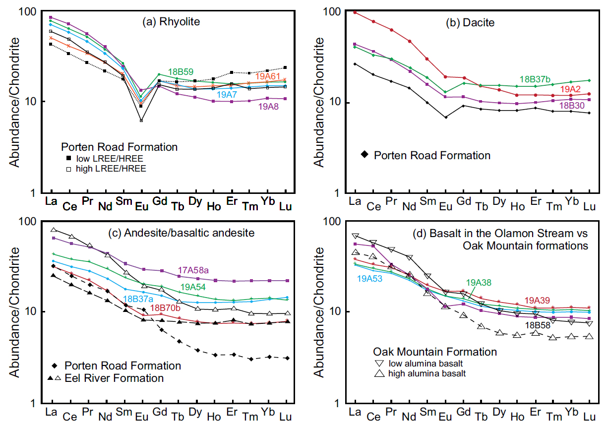 Display large image of Figure 19
54 We suggest that the similarities outweigh the differences and that, absent ages for the Stetson Mountain Formation and the Olamon Stream lower and basalt members in Maine, and the Eel River and Oak Mountain formations in New Brunswick, only broad correlation with the Meductic Group is possible. A volcanic arc 350 km long is unlikely to exhibit simple “layer-cake” stratigraphy or uniform lithologic and chemical profiles along its length, and the lithologic and chemical differences described above may indicate eruptions at different volcanic centers in a Maine–Meductic arc.
Correlation with Cambrian–Ordovician belts in northeastern Maine
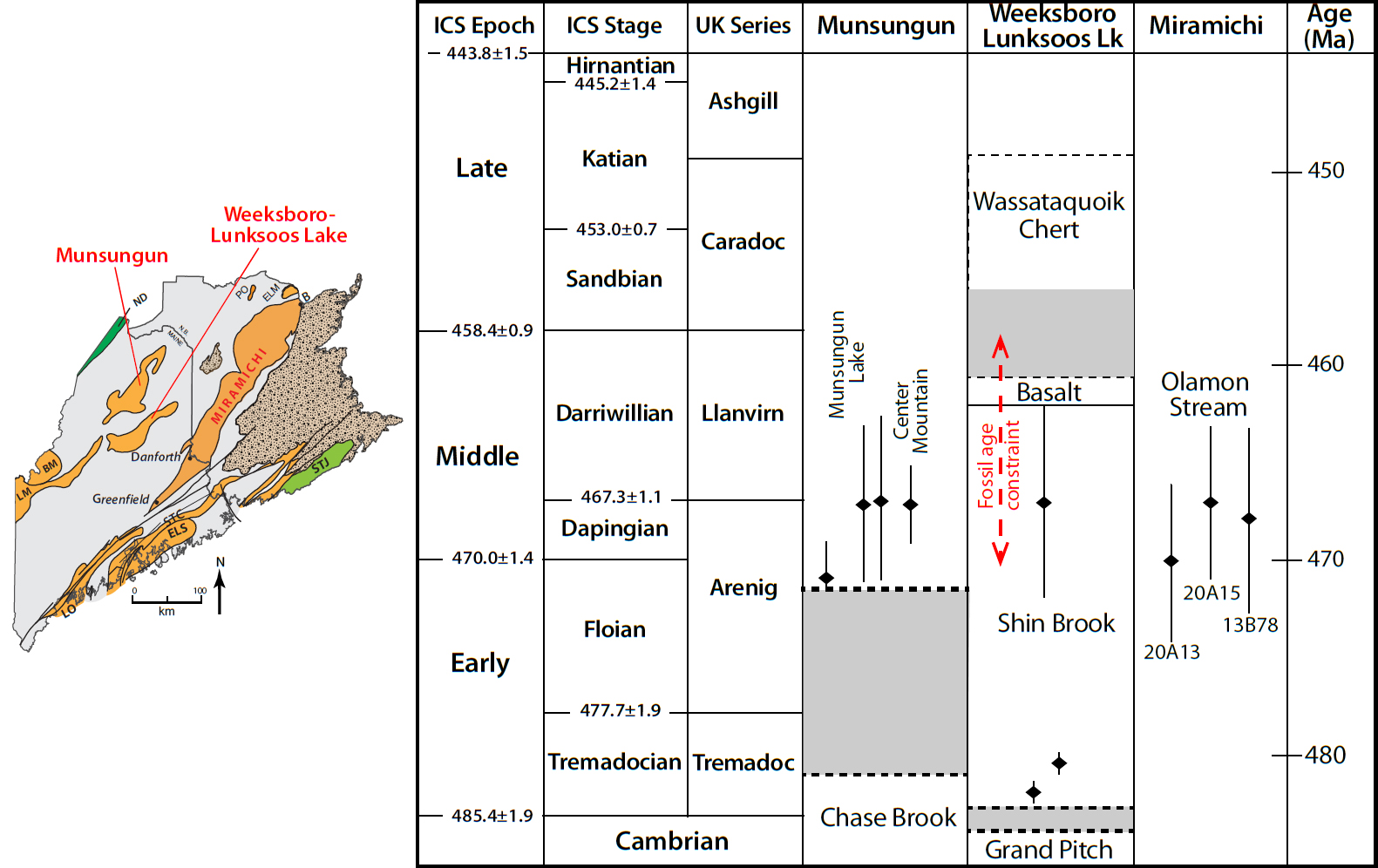
55 Large volumes of volcanic rock in the extensive Cambrian–Ordovician Weeksboro-Lunksoos Lake and Munsungun belts in Maine northwest of the Miramichi inlier (Fig. 1) had, until recently, been last studied at the dawn of the plate tectonic era (Neuman 1967; Hall 1970). Ongoing mapping by Wang (2018, 2019, 2021) and exploration at the Bald Mountain (Munsungun) and Pickett Mountain VMS prospects (W-L) are yielding new insights into volcanism during accretion of the leading edge of Ganderia to Laurentia, and coupled with this study, the geometry of that accretion (see below).
56 Weeksboro–Lunksoos Lake inlier: Ordovician volcanic rocks in this belt, approximately 75 km northwest of the Danforth segment, are mapped as the Shin Brook Formation, host of the Pickett Mountain VMS deposit. Stratigraphic, lithologic, and geochronologic details reported by Neuman (1967) strongly support correlation of the Shin Brook with the Stetson Mountain and Olamon Stream formations (Fig. 20).
 Display large image of Figure 20
57 The Shin Brook volcanic rocks, now including greenstone mapped by Neuman (1967) and Wang (personal communication 2021), lie unconformably on the Cambrian–Ordovician Grand Pitch Formation, a thick sequence of quartzofeldspathic sandstone very similar to and correlated with Miramichi rocks now included in the Baskahegan Lake Formation (Larrabee et al.1965; Ludman 1991). Neuman (1967) attributed this discontinuity to a “Penobscot disturbance”, now described as the Penobscot orogeny in northern Maine (Wang, 2018, 2019), and northern and eastern New Brunswick (van Staal et al. 2016). This relationship is unlike the relationships in the Maine Miramichi, and Eel River New Brunswick areas where Early Ordovician volcanic rocks lie conformably on a pre-volcanic anoxic substrate.
58 Early reports of the Shin Brook volcanic suite described dacitic and andesitic tuffs, breccias, agglomerates, and rare lavas overlain by basalt, based largely on petrographic properties and only a few chemical analyses (Ekren and Frischknecht 1967; Neuman 1967). Recent chemical analyses from boreholes at the Pickett Mountain VMS deposit (formerly Chase Mountain) confirm a largely bimodal rhyolite-basalt suite with subordinate andesite intruded by sub-volcanic felsic and mafic intrusions (McCormick 2021; C. Wang, personal communication 2021).
59 A rich trilobite and brachiopod faunal assemblage in intercalated volcaniclastic sedimentary rocks dates Shin Brook volcanism directly as late Early Ordovician to earliest Middle Ordovician (Neuman 1967) corresponding to ca. 470 to 458 Ma; Cohen et al. 2013, updated 2021). A 467 ± 5 Ma age for dacite reported by Ayuso et al. (2003) from the Pickett Mountain prospect was from a dyke that cuts the Shin Brook volcanic rocks and therefore serves as a minimum age for the formation. Preliminary ages of 484 ± 0.6 and 481 ± 0.6 Ma from that prospect suggest earlier volcanic activity (McCormick 2021) but need to be confirmed. The Weeksboro–Lunksoos Lake volcanic suite is thus partly older and partly coeval with the Miramichi volcanic rocks in Maine.
60 Munsungun inlier: The Munsungun inlier, about 50 km north of the Weeksboro–Lunksoos Lake belt, contains Early Ordovician volcanic rocks mapped in different parts of the inlier as the Munsungun Lake Formation and Round Mountain and Center Mountain volcanic suites (Wang 2018, 2019, 2021).
61 The early Ordovician volcanic rocks lie unconformably on the Chase Brook Formation, a Cambrian–Ordovician olistostromal mélange, a relationship similar to that in the Weeksboro–Lunksoos Lake inlier. Recent mapping indicates that this mélange can be traced to the northwest side of the Weeksboro–Lunksoos Lake inlier (C. Wang, personal communication 2021).
62 The Munsungun Lake Formation comprises mostly arc-related basalts intruded by subvolcanic diabase dykes and sills, with subordinate dacite and andesite. In contrast, the Round Mountain volcanic rocks are tholeiitic, primitive basalts exhibiting within-plate tectonic affinity (Wang 2021).
63 Munsungun inlier volcanic activity has also been dated as beginning at the boundary between the Early and Middle Ordovician: Munsungun Lake tuffs at 467 ± 4Ma (Ayuso et al. 2003), 471.2 ± 4.2 Ma (Wang 2019), and 468.2 Ma (Wang 2018). These ages indicate that calc-alkaline arc-related volcanism occurred simultaneously in the three Cambrian–Ordovician inliers in Maine, although to lesser extents in the northerly belts.
TECTONIC IMPLICATIONS
Middle Ordovician plate accretion: “Taconic” orogeny
64 Models for the timing and nature of events at the leading edge of Ganderia that first collided with Laurentia have been based largely on information from New Brunswick: the Miramichi and Elmtree inliers; the much smaller Popelogan inlier and even smaller Oxford Brook exposure to the west; and the Straughan Brook drill hole through the Carboniferous Maritimes Basin to the east (Fig. 1). Maine Miramichi volcanic data presented here, combined with new information from the extensive Weeksboro–Lunksoos Lake and Munsungun belts closer to that leading edge (Fig. 1), add significantly to our understanding of Ganderian accretion to Laurentia.
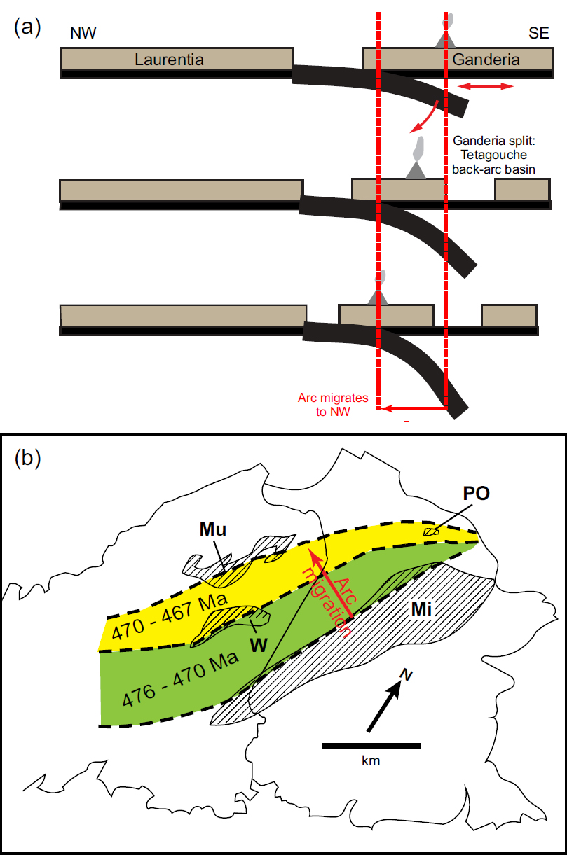
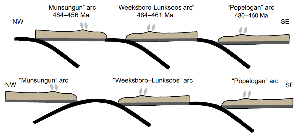
65 As described above, our geochemical data support the model of continental arc volcanism attributed to the Popelogan arc, and the Poplar Mountain volcanic suite is consistent with an intra-arc or back-arc rifting setting (Tetagouche Group), and subsequent closing of the back-arc basin (van Staal et al. 2016). That model proposed initial rollback of an eastward-dipping subducted slab beneath the Popelogan arc, accompanied by northwestward migration of arc volcanism, first to the Weeksboro–Lunksoos Lake inlier and eventually as far as the Munsungun inlier (Figs. 21a, b).
 Display large image of Figure 21
66 This model, however, is not consistent with simultaneous Floian–Dapingian volcanism in the three Maine inliers described above (Fig. 22), including at ca. 471–468 Ma in the Miramichi, Weeksboro–Lunksoos Lake and Munsungun inliers, and at ca. 480–484 Ma in the Meductic Group and possibly ca. 485–481 Ma in the Weeksboro–Lunksoos Lake inlier (Table 3). The current distance between the Miramichi and Munsungun inliers is about 150 km and although it is difficult to estimate the original span because of Ordovician extension and compression and Salinic and Acadian telescoping, it was almost certainly significantly greater than today.
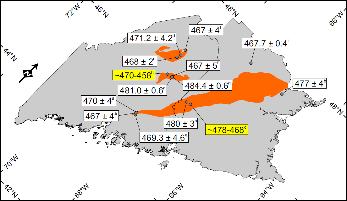 Display large image of Figure 22
 Display large image of Table 3
67 Even the current 150 km span is much wider than can be explained by a single shallow eastward-dipping subduction zone. We therefore propose that simultaneous Ordovician volcanism in the three inliers indicates eruptions in two or perhaps as many as three subduction zones (Fig. 23), analogous to the Molucca–Celebes Sea collision zones (Hall and Nichols 1990). The largely bimodal nature of Weeksboro– Lunksoos volcanism suggests a third possibility: that it and the Munsungun rocks may represent an arc/back-arc system comparable to that of the Meductic/Tetagouche rocks.
68 The multiple arc model would be more convincing if there were associated melanges like that accompanying Penobscot arc closure in the Munsungun inlier, or subduction complexes like that in the Bathurst area. The absence of these features, however, does not preclude a subduction-related arc. For many years, their absence from the Eastport–Mascarene volcanic belt in eastern Maine and southeastern New Brunswick prevented widespread acceptance of a subduction model, but Llamas and Hepburn (2013) argued convincingly for eruption over a west-dipping subduction zone.
Penobscot orogeny
69 Neuman (1967) was the first to recognize an unconformity in the Weeksboro–Lunksoos Lake inlier separating early Ordovician volcanic rocks (Shin Brook Formation) from the underlying Cambrian–Ordovician Grand Pitch Formation. This unconformity is now recognized in a broad area from the Munsungun inlier in northeastern Maine (Wang 2018), to northern (Bathurst area) and southeastern (Annidale area) New Brunswick and is attributed to a Penobscot orogeny related to early Ordovician terrane accretion on the trailing edge of Ganderia (Fyffe et al. 2011; van Staal et al. 2016).
70 This early Ordovician unconformity has not been recognized, however, in the southwestern part of the Miramichi inlier in Maine and New Brunswick. Instead, there is a continuous and gradational transition upward from the Woodstock Group to the Meductic Group as described above (Fyffe 2001; McClenaghan et al. 2016). Contact relationships are less clear in Miramichi exposures in Maine, but the basal Baskahegan Lake and Bowers Mountain formations appear to have experienced the same deformation history as the overlying Olamon Stream and Stetson Mountain formations.
71 Its absence does not refute the existence of a Penobscot orogeny, nor its tectonic interpretation, but does suggest that its geographic impact was more complex than previously interpreted, and that additional work is necessary to explain its absence.
CONCLUSIONS
- Volcanic rocks in the Danforth and Greenfield segments of the Miramichi inlier in Maine are dominantly pyroclastic andesite, dacite, and rhyolite, with subordinate lavas and agglomerates, and minor basalt only in the Greenfield segment.
- 2. Rocks from both segments are calc-alkaline, erupted in a continental-floored arc above a subduction zone.
- U–Pb zircon dating indicates arc activity in the Greenfield segment around ca. 469 Ma, at the boundary between the early and middle Ordovician (Floian–Dapingian), corresponding to the Meductic phase of Popelogan arc development.
- Coeval calc-alkaline eruptions in the Weeksboro– Lunksoos Lake and Munsungun Cambrian–Ordovician inliers in northeastern Maine are not consistent with tectonic models involving northwestward migration of a single arc, but rather suggest activity of multiple arcs.
Future research
72 This paper is a report of progress made during nearly half a century of mapping in the Miramichi Cambrian–Ordovician inlier in Maine (Ludman 1978, 1991, 2003, 2020, in press) and recent studies in the Munsungun inlier (Wang 2018, 2019, 2021). Much of that work is ongoing, and future improvements in understanding their stratigraphy and relationships with the cover rocks will undoubtedly require further revisions in regional tectonic models. Increased interest in volcanic-hosted ore deposits at Pickett and Bald mountains in the Weeksboro–Lunksoos Lake and Munsungun inliers has generated useful geochemical and geochronologic data and further development of these prospects will continue to provide valuable new information.
Additional mapping
73 Recent mapping in the Munsungun (Wang 2019, 2021) and Miramichi terranes in Maine has been aided by a vast network of lumber roads and recreational trails that provide access (and outcrops) in previously remote areas. Although mapping has vastly improved understanding of these inliers, little work has been done in the Weeksboro–Lunksoos Lake belt and more is needed.
74 The studies cited above reveal that multiple episodes of hitherto unsuspected faulting are responsible for the current relationships between Cambrian–Ordovician and cover rocks, and for juxtaposing strata within each inlier. Connecting those faults is as important as correlating stratified rocks – indeed, it is critical to understanding which of those units can be correlated.
Expanded geochronologic and geochemical studies
75 Improved understanding of Miramichi volcanic stratigraphy requires a strategic approach to sampling for both geochronology and geochemistry. For example, two of the three dates reported above for the Olamon Stream Formation in the Greenfield segment come from the upper member, and the third is from a large float block whose lithology is observed in both upper and lower members. Neither geochemical nor geochronologic data are available for the lower member, nor geochronologic data for basalt in the Olamon Stream Formation, and no geochronologic information from the Stetson Mountain Formation in the Danforth segment. These data are needed to confirm correlation with the Greenfield segment and make more precise correlations with the Meductic Group.
76 The age of the Meductic Group volcanic rocks in New Brunswick is based on a single sample from the basal Porten Road Formation (Mohammadi et al. 2019). Additional ages for that formation and from the overlying Eel River and Oak Mountain formations would reveal the duration of volcanism in this segment of the Popelogan arc and clarify correlation with the Miramichi volcanic rocks in Maine.
ACKNOWLEDGMENTS
Allan Ludman is grateful to the Maine Geological Survey for its encouragement and logistic support for more than half a century, with special thanks to State Geologist Robert Marvinney, and Henry N. Berry IV for their stimulating conversations and for editing previous publications covering the area. Chunzeng Wang generously shared geochemical data for volcanic rocks in the Munsungun terrane and his interpretation of their tectonic setting. Chris Halsted’s digital cartographic wizardry has made recent mapping far more efficient than in the early days.
A USGS State Map grant through the Maine Geological Survey partially supported mapping in the Greenfield segment, and the Maine Geological Survey paid for some of the early U–Pb dating. Henry Berry IV, Jeremy Braun, and Sam Onion helped to collect volcanic samples for dating on a “brisk”, very wet day.
We thank Les Fyffe, Cees van Staal, and Reginald Wilson for detailed reviews that clarified our understanding of complex relationships in New Brunswick and greatly improved this final version. We are, of course, responsible for any errors that remain. Finally, we are indebted to Dave West for his support and Chris White for his extraordinary efforts in editing the final manuscript.
REFERENCES
Editorial responsibility: David P. West, Jr.
APPENDIX A
 Display large image of Appendix A
APPENDIX B
 Display large image of Appendix B
APPENDIX C
 Display large image of Appendix C