Article
Recalculation of minimum wave heights from coastal boulder deposits in the Bristol Channel and Severn Estuary, UK:
implications for understanding the high-magnitude flood event of AD 1607
doi: 10.4138/atlgeol.2021.009
Abstract
A high-magnitude coastal flood event catastrophically affected the macrotidal Bristol Channel and Severn Estuary in southwest Great Britain, United Kingdom, on 30th January 1607 causing an estimated 2000 fatalities. Historical and physical evidence has provided a basis for the development of a theory that the flood may have been due to a tsunami rather than a storm. Previous studies have collected field data to test this hypothesis including a dataset of 136 wave-transported boulder clasts that was utilised to estimate minimum wave heights through hydrodynamic equations in 2007, but the dataset has hitherto remained unpublished in full. Since 2007 these equations have undergone refinement and for this paper minimum wave heights were recalculated from boulder measurements using revised hydrodynamic equations and presents the complete dataset for the first time. A recent study claiming that such equations are flawed is considered premature, given ongoing refinements to the equations. The results of the present study indicate that a tsunami 4.2 m high can explain the dislodgement of all boulders measured, equivalent to a storm wave height of 16.9 m, which is considerably greater than observed storm wave heights in the region. An up-channel increase in minimum wave height is also suggested by these data, generally corroborating the 2007 study, which may be due to wave amplification caused by the overall funnel-shape of the embayment. The areas worst affected by the 1607 flood are located in the coastal lowlands of the inner Bristol Channel and Severn Estuary, coinciding with the highest minimum estimated wave heights.
Résumé
Une inondation côtière de forte ampleur a frappé de façon catastrophique le canal de Bristol et l’estuaire du Severn dans le sud-ouest de la Grande-Bretagne, au Royaume-Uni, le 30 janvier 1607, y causant un nombre estimatif de 2 000 décès. Des indices historiques et physiques ont donné lieu à la formulation d’une théorie supposant que l’inondation pourrait avoir été attribuable à un tsunami plutôt qu’à une tempête. Des études antérieures avaient comporté la collecte de données sur le terrain pour vérifier cette hypothèse, notamment un ensemble de données de 136 clastes de blocs rocheux transportés par des vagues qui a été utilisé pour l’estimation des hauteurs minimales des vagues au moyen d’équations hydrodynamiques en 2007. L’ensemble de données n’avait toutefois pas été publié dans son intégralité jusqu’ici. Les équations ont été raffinées depuis 2007 : on a recalculé pour le présent article les hauteurs minimales des vagues à partir des mesures des blocs rocheux au moyen d’équations hydrodynamiques révisées et l’ensemble de données complet est présenté pour la première fois. Une étude récente alléguant que les équations en question sont erronées est considérée comme prématurée compte tenu des améliorations courantes des équations. Les résultats de l’étude actuelle révèlent qu’un tsunami de 4,2 m de hauteur peut expliquer le déplacement de tous les blocs rocheux mesurés, ce qui équivaut à une onde de tempête de 16,9 m de hauteur, soit une hauteur considérablement supérieure à celles des ondes de tempête observées dans la région. Les données laissent également supposer une augmentation en amont du canal de la hauteur minimale des vagues, corroborant de façon générale l’étude de 2007, qui pourrait être due à une amplification des vagues causées par la forme en entonnoir générale de l’échancrure. Les secteurs les plus affectés par l’inondation de 1607 se trouvent dans les basses terres côtières de l’intérieur du canal de Bristol et de l’estuaire du Severn, qui correspondent aux hauteurs estimatives minimales les plus élevées des vagues.
[Traduit par la redaction]
INTRODUCTION
1 In 2003, a theory was proposed that a widespread coastal flood event, which affected the Bristol Channel and Severn Estuary around the coasts of south Wales and southwest England on 30th January 1607, may have been due to the impact of a tsunami (Bryant and Haslett 2003). The theory was developed through a combination of, firstly, a rereading of contemporary historical accounts published as pamphlets or chapbooks that provide ambiguous accounts of the weather with some stating that the day was “most fayrely and brightly spred” (Bryant and Haslett 2003, p. 164) and, secondly, coastal geomorphological and stratigraphic evidence potentially linked to the event. Haslett and Bryant (2005) undertook further historical research of accounts from Devon and Cornwall, and Bryant and Haslett (2007) and Haslett and Bryant (2007a, b) reported field evidence that was utilised to evaluate the theory.
2 The impact of the 1607 flood was extensive, affecting 570 km of coastline and flooding 518 km2 of coastal lowlands causing great economic loss and an estimated 2000 fatalities (Bryant and Haslett 2007; Fig. 1) making it Great Britain’s worst historical natural disaster. Although some authors considered the 1607 flood to have been caused by a storm surge (e.g., Horsburgh and Horritt 2006; see also Haslett 2007), Kerridge (2005), in a UK Government report, concluded that “the most credible source for a strong, potentially damaging tsunami reaching the UK coast is a large passive margin earthquake in the Sole Bank area (western Celtic Sea)” (p. 29) directly offshore of the Bristol Channel.
 Display large image of Figure 1
3 Disney (2005a, b) referred to a second-hand report of an earth tremor being felt on the morning of the flood in 1607; however, it has not been possible to locate the historical source to support this statement. Nevertheless, Haslett (2011) identified from historical documents two previously uncatalogued seismic events that affected the region in 1607; the first occurred two weeks after the flood on 14th February and the second on 22nd May, suggesting that the year was a seismically active period. It is also possible that an earthquake may have triggered a submarine slide on the steep continental slope offshore Ireland (Kenyon 1987) that may have generated a tsunami, such as happened across the North Atlantic with a 13 m-high tsunami that struck the Burin Peninsula, Newfoundland, in 1929 (Heezen and Ewing 1952; Piper et al. 1999; Moore et al. 2007).
4 Bryant and Haslett’s (2007) field evidence collected to test the hypothesis included analysis of erosional coastal landforms and the dislodgement of boulders. They also acknowledged that the dating of coastal erosion features and boulder movement is challenging but were able to suggest a chronological link with the AD 1607 event based on a suite of evidence. For example, boulder dislodgement and transport at one site appears to have occurred in the period after AD 1590 but before AD 1634–1672, which overlaps with a significant episode of coastal erosion documented throughout the Bristol Channel and Severn Estuary that has been dated to the early seventeenth century (Allen and Rae 1987; Allen and Fulford 1992). Historical sources offer corroboration of extreme wave-energy during the 1607 event, such as the inland transport of a fully laden 60-t ship and the demolition of numerous buildings. Taken together, Bryant and Haslett (2007) suggested that a single catastrophic event is likely to account for this suite of features, which temporally excludes the Great Storm of 1703 as an alternative explanation. Nevertheless, additional field studies are required to expand the number of securely dated sites to test the hypothesis further. Boulders were investigated by Bryant and Haslett (2007) through the measurement of boulder clast axes (i.e. a, b, c for the longest to shortest axes, respectively) at a number of sites from which minimum wave heights required to initiate boulder movement (dislodgement) were derived based on the hydrodynamic equation of Nott (2003), which had been developed from previously published equations (Nott 1997).
5 Since 2007, a growing number of studies have analysed boulder deposits to investigate whether storm or tsunami waves have contributed to the evolution of coastlines around the World (e.g., Hansom et al. 2008; Spiske et al. 2008; Goto et al. 2009, 2010; Barbano et al. 2010; Scheffers et al. 2009, 2010; Costa et al. 2011; Lorang 2011; Paris et al. 2011; Erdmann et al. 2015, 2017; Watanabe et al. 2016; Cox et al. 2018; Haslett and Wong 2019a, b; Abad et al. 2020). However, some boulder studies have noted shortcomings in Nott’s (1997, 2003) hydrodynamic equations (Bourgeois and MacInnes 2010; Switzer and Burston 2010; Gandhi et al. 2017; Kennedy et al. 2017; Piscitelli et al. 2017; Cox et al. 2020) and, indeed, we agree that Nott’s versions of the equations are outdated and, therefore, should no longer be used. Subsequent studies have, however, further developed the hydrodynamic equations to refine them and to correct errors in previous versions of the equations, such as the work of Nandasena et al. (2011), Kain et al. (2012) and more recently Haslett and Wong (2019a). Yet despite ongoing refinements and corrections, Cox et al. (2020) claimed that all hydrodynamic equations derived from Nott’s (1997, 2003) seminal work should be regarded as flawed.
6 Notwithstanding these ongoing developments, the present study aims to recalculate minimum wave heights derived from boulder clasts investigated by Bryant and Haslett (2007) using the revised formulae of Haslett and Wong (2019a) and to consider the significance for understanding the historical high-magnitude flood event of January 1607 in the Bristol Channel and Severn Estuary. The presentation of updated results, in light ofthe revised hydrodynamic equations, serves to better inform other researchers and the public. For example, public sources, such as newspaper articles (e.g., Barnes 2020), continue to refer to previous estimates of wave heights for the 1607 event; those earlier results are now refined and superseded by the present study.
METHODS
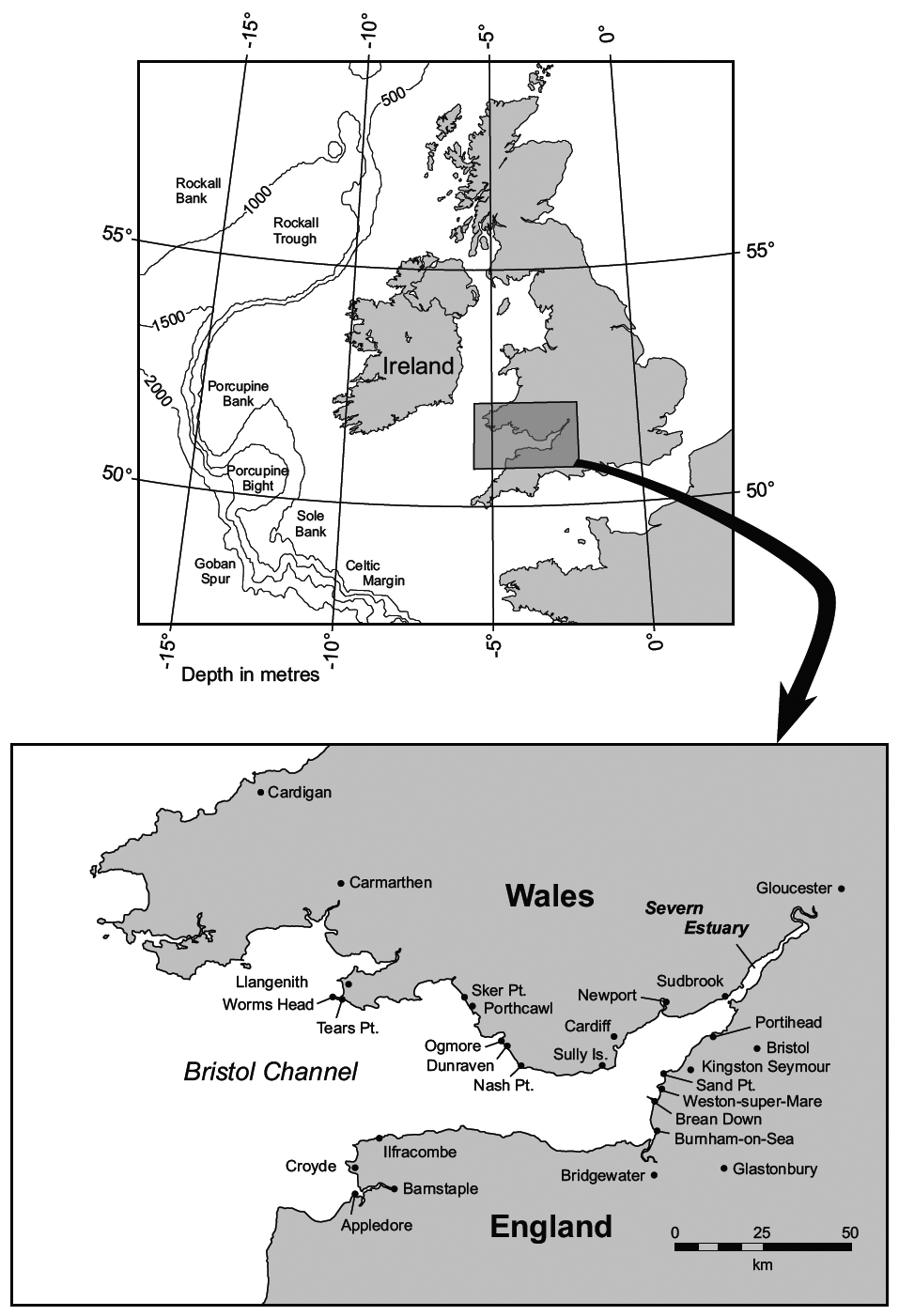
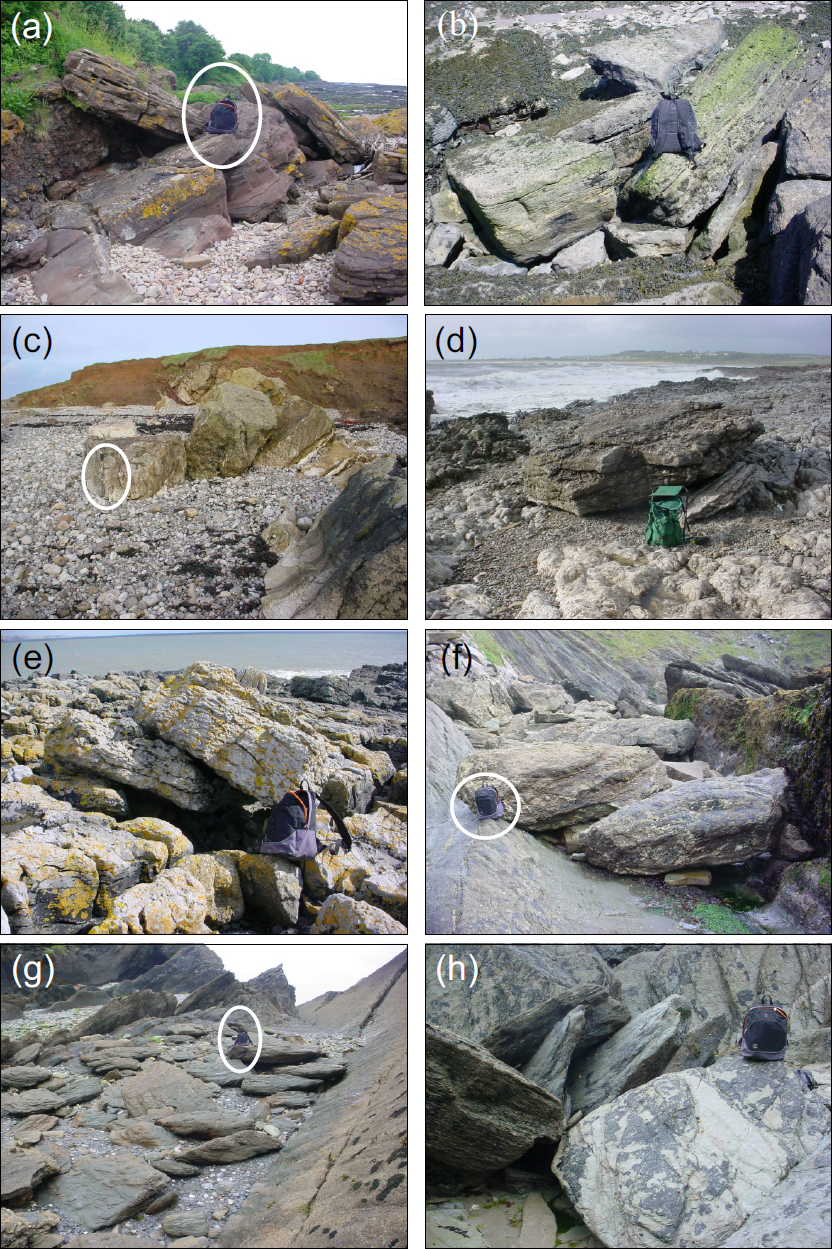
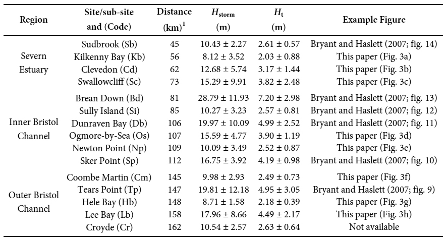
7 The study area is shown with principal sites in Figure 2, and details of the sites are presented in Table 1, categorised using the three zones defined by Bryant and Haslett (2007): the outer Bristol Channel, the inner Bristol Channel, and the Severn Estuary. Bryant and Haslett (2007) reported that 136 boulders were measured as part of their study, 129 of which appear to have been wave transported and seven clasts comprising an untransported boulder lag deposit derived from cliff retreat at Dunraven Bay (boulders DbL1-7), the significance of which for inclusion in their study was for dating boulder dislodgement (Bryant and Haslett 2007 pp. 264–266). From this dataset, Bryant and Haslett (2007) presented data for nine boulders only, being those from sites where the boulder was estimated to have the greatest resistance to flow within an area of each zone, both from storm and tsunami waves, as indicated by the formulae they used. Given that formulae are likely to continue to be developed and refined, the full dataset is presented here enable future use of these data (Appendix A, Table A1).
 Display large image of Figure 2
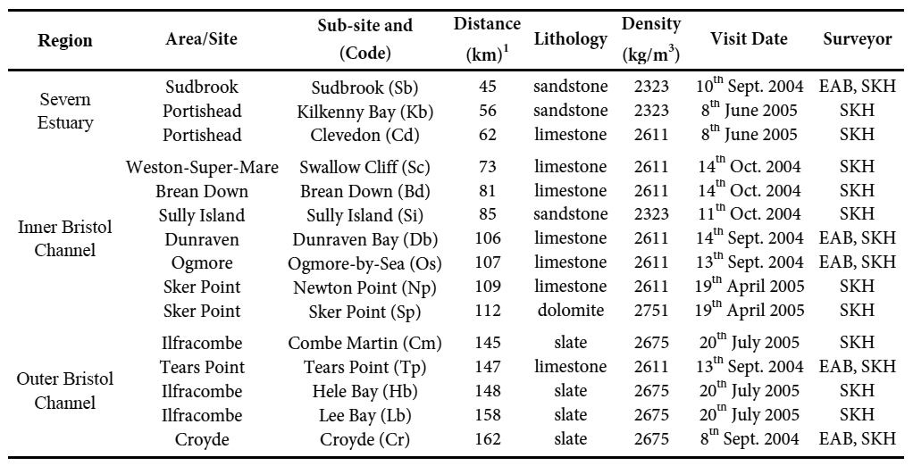 Display large image of Table 1
The formula used by Bryant and Haslett (2007) to test the hypothesis is for boulders in a submerged pretransport setting (Nott 2003), as the 1607 event is known from historical sources to have struck the Bristol Channel and Severn Estuary at high tide, meaning that the extensive intertidal zone would have been submerged at the time. Therefore, for comparative purposes, for this paper, minimum storm and tsunami wave heights were recalculated using the revised hydrodynamic equation of Haslett and Wong (2019a) for boulders in a submerged pre-transport setting. To provide an estimate for an upper limit of the minimum wave height required, calculations for joint-bound boulders were also made (Nandasena et al. 2011; Haslett and Wong, 2019a). Consequently, a range of minimum wave heights is presented for each boulder where an estimated range is provided by the formulae for submerged and joint-bound pre-transport settings.
8 For clarity, the equations used in this study are given here as equations 1 and 2 for boulders in submerged and joint-bound pre-transport settings (equations 6b and 8d of Haslett and Wong, 2019a) respectively:
and
where H is wave height (m); b and c are the measurements (m) of the intermediate and shortest axes of a boulder; Cl is the lift coefficient of 0.178; Cd is the drag coefficient of 1.2; ρs is the density of a boulder (kg m-3); ρw is the density of water (1020 kg m-3); θ is the shore slope angle, estimated here to be 10˚; μs is the static friction coefficient of 0.7; and δ is a wave-type parameter, which is δ = 4 for tsunami and δ =1 for storm waves (for a full explanation see Haslett and Wong 2019a). The minimum speed/velocity (u, m s-1) at which a wave impacts a boulder is also calculated for a submerged pretransport setting derived from Equation 6a of Haslett and Wong (2019a).
9 In their analysis, Bryant and Haslett (2007) referred to observed wave height data to provide the modern context for comparison with calculated minimum wave heights derived from boulder measurements. In the eastern North Atlantic area, the maximum deep-water wave height is 35 m with a 50-yr return period (NERC 1991), but the continental shelf shallows eastwards so that wave heights become ≥10 m in the outer Bristol Channel. However, in the shallower and more protected inner Bristol Channel and Severn Estuary, 50-yr return period waves of 4.7 m and 3.5 m, respectively, occur (McLaren et al. 1993). These observed wave heights are utilised in the present study for comparative purposes. However, the caution of Stephenson and Naylor (2011) should be noted in that some “boulders used to reconstruct past energy regimes [along the South Wales coast] may underestimate wave energies, if the blocks have been broken since detachment” (p. 23).
RESULTS AND DISCUSSION
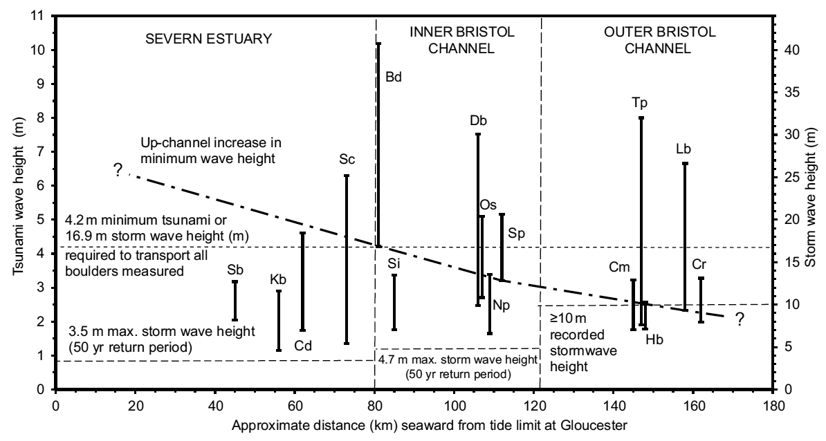
10 Dimensions of the 136 boulders measured in the field are presented in Appendix A (Table A1) along with the measured imbrication direction for each boulder, as reported by Bryant and Haslett (2007). Imbrication is considered an indication of the direction from which the flow responsible for transport, and subsequent deposition, originated (see Fig. 3 for examples). Mean imbrication was analysed by Bryant and Haslett (2007) who concluded that at their nine sites “wave refraction is not efficient, a feature of tsunamis more than storm waves” (p. 263); the matter is not revisited further in the present study. From these data the range of recalculated minimum wave heights under storm (Hstorm) and tsunami (Ht) scenarios are derived for each site and presented in Table 2 along with wave velocity (u). These wave height data are also plotted in Figure 4 against approximate distance (km) seaward from the tide limit at Gloucester, along with observed wave heights for the outer and inner Bristol Channel and Severn Estuary from McLaren et al. (1993). In the outer Bristol Channel five sites were investigated. Boulders measured at Hele Bay, Coombe Martin, and Croyde indicate a similarly low range of minimum wave heights required to initiate movement, whereas boulders at Lee Bay and Tears Point indicate a much higher range. However, in each case the threshold for boulder dislodgement in a submerged pretransport setting is less than observed storm wave heights for the zone of ≥ 10 m (McLaren et al. 1993). Therefore, although all the boulders at the outer Bristol Channel sites may have been dislodged by Ht ≥ 2.3 m, dislodgement at each site may also be explained by Hstorm ≥ 9.3 m.
 Display large image of Figure 3
 Display large image of Table 2
 Display large image of Figure 4
11 Bryant and Haslett (2007) also concluded that it is theoretically possible that boulders at the outer Bristol Channel sites may have been dislodged by storm waves but recognised that in the “inner Bristol Channel and in the Severn Estuary, the required Hstorm [for boulder dislodgement] is significantly greater than observed storm wave heights” (p. 263). The present study corroborates this observation; in these two zones, results from all sites yield Hstorm greater than observed storm wave heights reported by McLaren et al. (1993) and the dislodgement of all boulders may be explained by Ht ≥ 4.2 m or Hstorm ≥ 16.9 m (Fig. 4). This result is derived from Brean Down, located on the boundary between the inner Bristol Channel and the Severn Estuary, and as such may reasonably be taken to represent both zones.
12 Given observed storm wave heights (50 yr return period) of 4.7 m and 3.5 m in the inner Bristol Channel and Severn Estuary, respectively (McLaren et al. 1993), which are significantly lower than Hstorm ≥ 16.9 m, the recalculations presented here agree with Bryant and Haslett’s (2007) conclusion that boulder dislodgement in these zones was “achieved not by storm waves but by tsunamis” (p. 263). Clearly, if this is the case for the inner Bristol Channel and the Severn Estuary, then boulders in the outer Bristol Channel could also have been dislodged by Ht ≥ 4.2 m but reworking by subsequent storm waves and/or meteorological tsunami remains a possibility for boulders at these outer Bristol Channel sites (see Haslett and Bryant 2009).
13 Accepting that boulder dislodgement in the Bristol Channel and Severn Estuary is more likely to have been due to a tsunami than storm waves, Bryant and Haslett (2007) were able to recognise an up-channel increase in Ht, due to wave height amplification conjectured to have been caused by the overall funnel-shape of the embayment, an observation that is fundamentally replicated in this study. However, details vary between the two studies in that Bryant and Haslett (2007) recognised an increase from Ht ≥ 4 m in the outer Bristol Channel, to Ht ≥ 5 m in the inner Bristol Channel, to Ht ≥ 6 m in the Severn Estuary. In the present study, Ht increases from ≥ 2 m in the outer Bristol Channel to ≥ 4 m in the inner Bristol Channel and the Severn Estuary.
14 Data from Sker Point, however, suggest that Ht ≥ 3 m was experienced close to this site near the boundary between the outer and inner Bristol Channel. From these data, interpolation of minimum wave heights between the key sites of Lee Bay, Sker Point, and Brean Down is plotted on Figure 4. Extrapolation beyond the end sites permits reconstruction of the possible up-channel increase in wave height, relocating the 5 m and 6 m theorised tsunami wave height of Bryant and Haslett (2007) further up-channel to approximately 55–60 km and 25–30 km seaward from Gloucester, respectively. These results, embracing those of Bryant and Haslett (2007) that were derived from an earlier outdated version of the equation (Nott 2003), represent the minimum threshold for boulder dislodgement and, therefore, do not discount the possibility that a higher tsunami wave affected these sites.
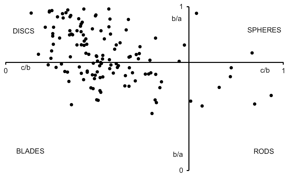
15 Shape analysis of these wave-transported boulders (excluding the seven boulders from the Dunraven Bay lag deposit) is presented here using the Zingg (1935) method, c/b and b/a results derived from the measurements of 129 wave-transported boulders in Table 2 are plotted on a Zingg diagram in Figure 5. It is clear from these data that disc-shaped boulders dominate the sample with 71 clasts (55.04% of sample), followed by 49 blades (37.98%), with minor components of seven rods (5.43%), and two spheres (1.55%). The dominance of discs and blades within the sample is not surprising given the mainly sedimentary geology of the region and the prevalence of well-bedded stratigraphic units that are predisposed to produce tabular clasts upon erosion/quarrying from bedrock. Furthermore, disc-shaped clasts are more likely to be evidently imbricated, meeting the field criteria for wave-transported boulders and, therefore, selected for measurement.
 Display large image of Figure 5
16 The results derived from this study overall are consistent with those of Bryant and Haslett (2007) and the historical contemporary accounts of the 1607 flood (e.g., Anon 1607). Although some locations in the outer Bristol Channel were badly affected, such as north Devon where Ht ≥ 2 m (Haslett and Bryant 2005), the most catastrophically affected areas were the coastal lowlands of the Somerset Levels in the inner Bristol Channel (Ht = 3–4 m), as far inland as Glastonbury (Fig. 2), and the Severn Estuary (Ht ≥ 4 m, possibly rising to 5–6 m up-channel), from around Cardiff and Weston-Super-Mare up-channel towards Gloucester (Fig. 2; see also Skellern et al. 2008). It is in these areas that most of the ca. 2000 fatalities occurred on the morning of 30th January, 1607, due to the direct impacts of the catastrophic flood and its aftermath.
CONCLUSIONS
17 The entire dataset of 136 boulder clasts employed by Bryant and Haslett (2007) as part of their investigation into the impact of the 1607 flood in the Bristol Channel and Severn Estuary are used here to recalculate minimum wave heights for both storm waves and tsunamis using the revised hydrodynamic equations of Haslett and Wong (2019a). The results provide overall corroboration of the Bryant and Haslett (2007) study in that the data suggest that boulder dislodgement in the region was achieved not by storm waves but by tsunamis. The present study also corroborates an upchannel increase in tsunami wave height most likely due to wave amplification in the funnel-shaped embayment. The new results suggest that a tsunami ≥ 4.2 m high accounts for the dislodgement of all measured boulders (excluding a lag deposit) in the sample. Extrapolation suggests that a tsunami wave height up to 5–6 m is possible within the Severn Estuary where the impact of the 1607 flood on the coastal lowlands was most catastrophic.
ACKNOWLEDGEMENTS
The authors would like to thank two anonymous reviewers and editors, especially Sandra Barr, for their comments on an earlier version of the manuscript. This study is a contribution to UNESCO’s International Geoscience Program (IGCP) Project 639 Sea Level Change from Minutes to Millennia, and the Celtic Coasts Project. The writing of this paper and the recalculation of the boulder dataset were undertaken whilst SKH was in receipt of a Short-Term Visiting Fellowship at Jesus College, University of Oxford. He is grateful to the staff of Bodleian Library, Oxford, for their assistance in providing access to 17th century documents held in the collection. The revision of the hydrodynamic equations was undertaken by SKH and BRW while SKH was Visiting Professor at the University of Malaya. Field surveys were undertaken whilst SKH was at Bath Spa University. The authors are grateful to each of the institutions listed above for their support.
REFERENCES
Editorial responsibility: Sandra M. Barr
APPENDIX
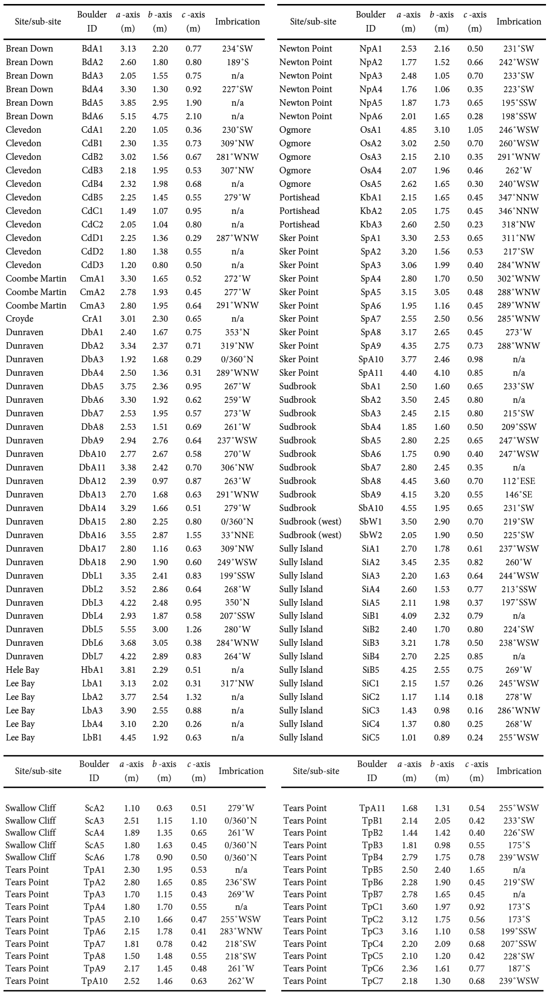 Display large image of Table A1