Relict seawater as a source of stratified groundwater in glaciated estuarine valleys:
an example from Fredericton Junction, New Brunswick
Gina M. GiudiceNew Brunswick Department of Environment, P.O. Box 6000, Fredericton, NB E3B 5H1, Canada
gina.giudice@gnb.ca
Bruce E. Broster
Department of Geology, University of New Brunswick, Fredericton, NB E3B 5A3, Canada
broster@unb.ca
Date received: 15 December 2005 ¶ Date accepted: 15 August 2006
ABSTRACT
Recent investigations of the local geology and hydrogeological environment for the Village of Fredericton Junction, New Brunswick, identified a lower bedrock aquifer as the main water supply aquifer for both municipal and domestic wells. Within the aquifer, potable water overlies brackish water that increases in salinity at depth. The aquifer is overlain mostly by fine-grained glacial sediments that limit recharge to the lower bedrock aquifer. Recharge to the bedrock aquifer primarily occurs at outcrops along local rivers and from deeper regional groundwater systems. While nearby rivers receive run-off from local roads and municipal areas, geochemistry of the brackish water does not support this water as a source of the saline contamination. Examination of drill records from groundwater exploration within the Carboniferous sedimentary bedrock of New Brunswick indicates that groundwater is commonly stratified, forming a surface zone of fresh water overlying a zone of saline water at depth. While saline intrusion of aquifers is known to be a hazard for coastal communities from disturbance to the freshwater/saltwater interface, drilling records indicate that glaciated estuarine valleys may be especially at risk to salinization exacerbated by unrestricted exploitation. Drilling data demonstrate that saline water is most frequently encountered along valleys that were estuaries during the Late Wisconsinan glaciation, approximately 14 000– 12 000 years ago. During that time, many inland valleys were open to the ocean and surrounded by masses of melting ice. It is proposed that saline water from that time has remained preferentially in pockets within the bedrock underlying these valleys.RÉSUMÉ
De récentes études de la géologie régionale et du milieu hydrogéologique du village de Fredericton Junction, au Nouveau-Brunswick, ont permis de repérer une formation aquifère du substratum rocheux inférieur, qui est la principale source d'eau du réseau d'aqueduc municipal et des puits résidentiels environnants. Dans cette formation aquifère, l'eau potable est sus-jacente à l'eau saumâtre, laquelle gagne en salinité en profondeur. La formation aquifère est recouverte essentiellement par des sédiments glaciaires à grain fin qui limite la recharge à la formation aquifère du substratum rocheux inférieur. La recharge de la formation aquifère du substratum rocheux survient principalement par des affleurements rocheux observés en bordure des cours d'eau de la région et de réseaux hydriques souterrains régionaux plus profonds. Les rivières environnantes reçoivent les eaux de ruissellement des chemins et des approches de la municipalité, mais les propriétés géochimiques de l'eau saumâtre ne permettent pas de désigner cette eau comme la source de la contamination saline. L'examen des travaux de forage d'exploration d'eau souterraine dans le substratum rocheux du Carbonifère du Nouveau-Brunswick, indique que l'eau souterraine se présente souvent sous forme de nappes et forme un horizon d'eau douce qui se superpose à une zone d'eau salée située en profondeur. L'infiltration de l'eau salée dans une formation aquifère est certes un danger pour les collectivités habitant une zone côtière, eu égard à la perturbation causée par le mélange de l'eau douce et de l'eau salée, mais les données de forage indiquent que les vallées glaciaires estuariennes peuvent être particulièrement exposées à une contamination par l'eau salée, une situation que peut aggraver une exploitation non balisée des ressources en eau. Les données de forage indiquent par ailleurs que la présence de l'eau salée est surtout observée en bordure de vallées qui formaient des estuaires à l'époque de la glaciation du Wisconsin supérieur, il y a environ entre 14 000 et 12 000 ans. Au cours de cette période, un grand nombre de vallées à l'intérieur des terres donnaient sur l'océan et étaient entourées de masses de glace fondante. Il est suggéré que l'eau salée datant de cette époque a été confinée selon toute vraisemblance dans des poches du substratum rocheux sous-jacent de ces vallées. [Traduit par la rédaction]INTRODUCTION
1 The Village of Fredericton Junction is a small municipality of approximately 700 people, situated in southwestern New Brunswick, approximately 40 km south of the city of Fredericton (Fig. 1). The area lies wholly within the New Brunswick Lowlands Physiographic Division, a subdivision of Bostock's Appalachian Region of eastern Canada (see Rampton et al. 1984). The site is situated near the junction of the North and South branches of the Oromocto River. The North Branch Oromocto River occurs directly to the south of the centre of Fredericton Junction and joins the northward flowing South Branch Oromocto River approximately 3 km to the east of Fredericton Junction (Fig. 1). At this point, the South Branch becomes the main Oromocto River, a large tributary emptying into the Saint John River approximately 25 km to the north (Fig. 1).
2 The village is underlain by a blanket of unconsolidated sediments (till, clayey-silt, and sand) over sedimentary bedrock of Carboniferous/Pennsylvanian age. Previous geological and hydrogeological investigations have provided stratigraphic and groundwater data for the Fredericton Junction area (ABP Consultants Limited 1979; Godfrey Associates Limited 1996; Neill and Gunter Limited 2004, 2005; Giudice 2005). Initial research by the authors involved drilling and the collection of samples for geochemical and geotechnical analyses of subsurface sediment (see Giudice 2005). The present study examines the hydrogeological environment and geological units from which the municipal groundwater supply is withdrawn, water quality within the aquifer, and the vulnerability of the aquifer to surface contamination. An understanding of the above is essential for the reliability, sustainability, and protection of any municipal drinking water supply.
Surficial and bedrock geology
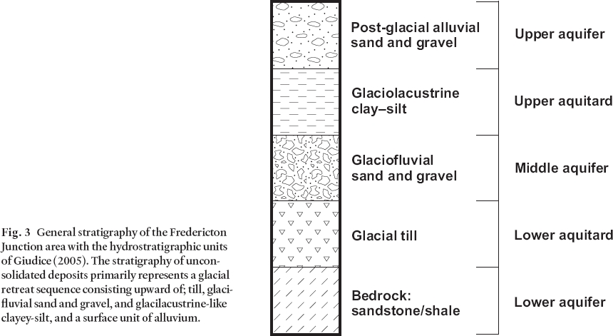
3 The stratigraphy of unconsolidated sediments beneath Fredericton Junction has been examined in several investigations of the subsurface that focused primarily on groundwater exploration and bridge construction (Subsurface Surveys 1976; ABP Consultants Limited 1979; Neill and Gunter Limited 2004, 2005; Giudice 2005). Locally, the surface is blanketed by extensive till cover, occasionally reaching depths up to 38 m. The till is sporadically overlain by Late Wisconsinan ice-contact and glacifluvial sand and gravel deposits of variable thickness. With the exception of the till unit, the unconsolidated sediments are present in greatest thickness underlying the bottom of the valleys and occur rarely at higher elevations (Giudice 2005). The stratigraphy of unconsolidated deposits (Fig. 3) represents a glacial retreat sequence (Broster 1994) consisting of, from bottom to top, till, glacifluvial sand and gravel, glacilacustrine-like clay-silt, overlain by a surface unit of alluvium (Gadd 1973; Rampton et al. 1984; Thibault 1981; Giudice 2005). The clayey-silt unit overlies bedrock and is rarely found along river exposures in the area.
4 Examination of the clay-silt at Fredericton (Daigle 2005) and Fredericton Junction (Giudice 2005) indicates that it is regionally extensive and was deposited during a marine transgression into isostatically-depressed areas and major river valleys, at the end of the last glaciation. The deposit varies in geochemical and geotechnical properties from location to location, likely in response to variation between freshwater from melting glacier ice-fronts and saline water from the marine incursion. At the city of Fredericton the sediment properties also vary between the two environments (Daigle 2005; Giudice 2005). However, at Fredericton Junction, Giudice (2005) concluded that the local deposits are primarily lacustrine-like because of their ‘ varved' appearance, low chloride content, mineralogy, and plasticity index and liquid limit values. The term glacilacustrine is used herein because it best reflects the character of the local deposits.
5 The bedrock underlying the study area is of sedimentary origin and comprises the Minto Formation that consists primarily of sandstone, conglomerate, and siltstone of Carboniferous age (or younger) (ABP Consultants 1979; Clark 1962; Gadd 1973; Thibault 1981). Weathered, reddish-grey sandstone interbedded with grey shale is exposed on the north side of the North Branch Oromocto River at the Highway 101 bridge crossing in the village (Fig. 4), whereas red pebble conglomerate bedrock is exposed on the south side. The bedrock strata dip shallowly to the north, with conglomerate underlying interbedded layers of sandstone and shale. Parting along bedding planes and a near-surface zone of intensive fracturing commonly is reported from excavations of the bedrock – till interface (Broster and Burke 1990; Broster and Park 1993a, b).
Glacial history
6 The glaciation and deglaciation of southwestern New Brunswick has been well studied (e.g., Lee 1957; Gadd 1973; Thibault 1981; Rampton et al. 1984; Seaman 1989, 2004; Seaman et al. 1993; Pronk et al. 2003). All studies agree that during the Late Wisconsinan the area was glaciated by southerly to southeasterly flowing glaciers. The land was isostatically depressed under the weight of the ice, enabling the lowland areas to be flooded as ice-masses retreated to higher elevations. Seaman (2004) suggested that deglaciation in this area began approximately 14 000 years ago with regional ice stagnation and down-wasting, which formed a large subglacial drainage network, likely following topographic depressions. The combination of isostatic depressed areas and eustatic change in sea-level resulted in the near-complete submersion of southern and eastern parts of the province under marine, brackish or freshwater (Gadd 1973; Thibault 1981; Rampton et al. 1984). Seaman (2004) suggested that ice retreating northward along the Saint John River Valley may have impeded drainage resulting in the creation of an ice-dammed lake in the Fredericton – Fredericton Junction area.
Fig. 1 (Facing Page) Location map of the Fredericton Junction area. The Fredericton Junction concentrated area of study is indicated by the open box. The North and South branches of the Oromocto River and the Saint John River are indicated. Also indicated are the locations of boreholes proximal to the study area, in which high chloride concentrations were detected in formational waters. The insert shows the regional location of the area and the extent of the Pennsylvanian sedimentary bedrock indicated by the large triangular-shaped area underlying the eastern half of New Brunswick. The star indicates the location of Youngs Cove.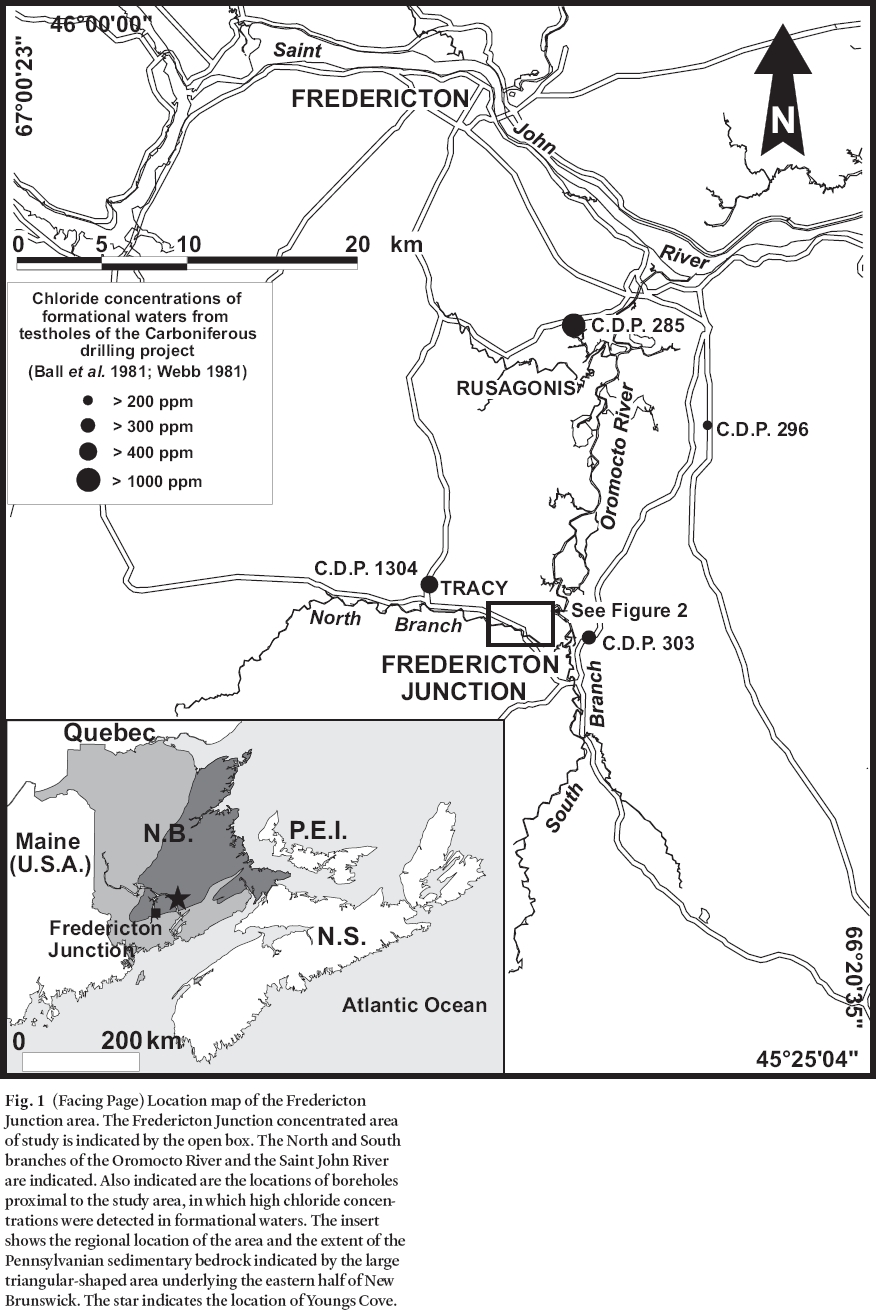
Display large image of Figure 1

Display large image of Figure 2
Display large image of Figure 3
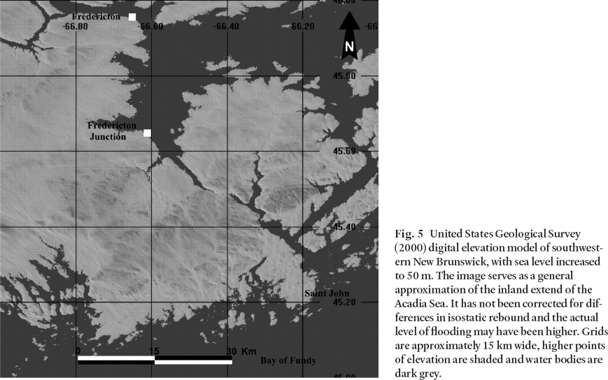
7 Full inundation of the Saint John River Valley is believed to have occurred at about 12 000 BP (Rampton et al. 1984) with incursion of marine water into central New Brunswick forming the so-called inland Acadia Sea (Fig. 5). The maximum height of the marine incursion is not known and estimates of this level may lack precision due to the occurrence of raised deltas and strandlines that represent proglacial or glacilacustrine lakes deposited prior to marine inundation. Blankets of marine sediments are common at elevations below 15 m (Gadd 1973) along the valleys of major rivers emptying into coastal waters. However, Thibault in Seaman et al. (1993) suggested that the incursion may have reached 89 m in elevation at its maximum. Nonetheless, raised deltas and clay/silt deposits believed to be of marine origin are present up to elevations of 60 m along Kennebecasis Bay (Rampton et al. 1984). Flooding at that level would have inundated the Oromocto River Valley as well, regardless of the possibility of small differences in isostatic rebound between areas. Although the exact elevation of the marine incursion in the study area remains unknown, Seaman et al. (1993) suggested that at about 10 500 BP sea level was near the present level due to isostatic rebound of the interior. Thus, samples of relict saline water from this time could be expected to return radiogenic dates near this age.
Fig. 4 Bedrock contact between the interbedded sandstone and shale units and the underlying conglomerate unit. The picture was taken facing north at the small picnic area by the Route 101 Bridge in Fredericton Junction proper (star in Fig. 2). Alternating layers of sandstone and shale are exposed on the north bank of the North Branch of the Oromocto River and the conglomerate is shown outcropping in the river. The sandstone bedrock overhang is evidence of bedrock erosion from the river. The thickness of the telephone pole between the arrows is approximately 30 cm (1 foot).Fig. 5 United States Geological Survey (2000) digital elevation model of southwestern New Brunswick, with sea level increased to 50 m. The image serves as a general approximation of the inland extend of the Acadia Sea. It has not been corrected for differences in isostatic rebound and the actual level of flooding may have been higher. Grids are approximately 15 km wide, higher points of elevation are shaded and water bodies are dark grey.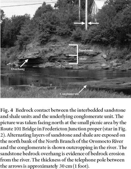
Hydrostratigraphy
8 Three aquifers have been interpreted (Giudice 2005) to underlie the Fredericton Junction study area, informally named the "Upper", "Middle" and "Lower" Aquifers (Fig. 3). The Lower (supply) Aquifer is fractured bedrock consisting of interbedded sandstone and shale of the Minto Formation. It is separated from the Middle Aquifer by a till unit, herein referred to as the lower aquitard. The lower aquitard is a reddish-brown lodgement till layer that tends to be dominantly clayey or silty in composition. The till forms a dense layer at depth and has been found to occur up to 38 m in thickness (Giudice 2005). It is consistently present in the study area and is relatively impermeable, allowing it to hydraulically and stratigraphically confine the lower aquifer and provide protection from surface contamination. The Middle Aquifer consists of a confined, glacifluvial, sand and gravel unit that has been previously reported to occur in thicknesses of up to 12 m in the study area (Giudice 2005). If these deposits can be found in sufficient quantities, such as a buried bedrock valley, they would provide a suitable target for the extraction of potable water.
9 The Middle Aquifer is separated from the Upper Aquifer by a lacustrine clay-silt unit, herein referred to as the upper aquitard. This unit is not consistently present in the area and has been found in the study region only at elevations below 20 m above sea level (Rampton et al. 1984; Daigle 2005; Giudice 2005). It therefore acts as a semi-confining layer to the underlying Middle Aquifer and has been documented by Giudice (2005) to occur locally at thicknesses of up to 27 m. The Upper Aquifer consists of unconfined, unconsolidated post-glacial sands and gravels. Given the range of thickness of this unit in the study area (1 to 10 m) (Giudice 2005), it is conceivable that shallow wells could draw water from this aquifer. However, the Upper Aquifer is the unit most prone to contamination from surface sources. It should be noted that this unit has been excavated extensively in the area for use as aggregate (Hamilton and Carroll 1975; Thibault 1981).
HYDROGEOLOGY
10 The municipal water supply is presently obtained from three production wells situated in the Lower Aquifer, which has historically proven to be the most productive for providing a sustainable drinking water resource (Figs. 2, 3). Current extraction from the aquifer is approximately 170 m3 of water per day, servicing approximately 60% of the village's 700 residents (LeBlanc and Lloy 2003). The water demands for the other 40% of the population are supplied from individual domestic wells.
11 A review of 47 domestic well logs in the area revealed that the majority of these wells obtain their water supply from the same sandstone unit. The bedrock is locally susceptible to recharge along slopes where rare outcrops are exposed due to erosion of the surface till cover and along the bed of local rivers. The major sources of continuous recharge of potable water to the bedrock are likely from the local rivers and a deeper, regional groundwater system. Lakes and swamps located at higher elevations in the surrounding watershed, about 15 km to the west and northwest, most likely contribute to this regional groundwater system.
12 Well yields in the bedrock aquifer are variable and dependent on fracture density. Much of the fracturing in the near-surface bedrock is the result of glaciation and surface weathering. Areas of high-density fracturing yield the most productive wells. For example, Broster and Park (1993a, b) and Park and Broster (1996) discussed examples of water flow and resulting hazards from open glacigenic fractures that were encountered to depths of 130 m in metamorphic bedrock at Heath Steel Mines, northern New Brunswick. One fracture encountered there during tunneling at 70 m depth was connected to a swamp at ground surface, resulting in a natural flow of groundwater from the fracture into the tunnel that exceeded 14 litres per second and yielded approximately 30 M litres within 23 days (Broster and Park 1993a).
Municipal well yields
13 Several municipal groundwater exploration programs have occurred and are in progress in Fredericton Junction (ABP Consultants Limited 1979; Godfrey and Associates Limited 1996; Neill and Gunter Limited 2004, 2005). Two of the municipal production wells, Well 1 and Well 2 (Fig. 2), were drilled as part of the 1979 groundwater exploration program. The wells are approximately 30 m apart, the aquifer characteristics are similar in each well, and they are hydraulically connected to each other (Jacques Whitford Environment Limited 2003). Freeze and Cherry (1979) considered transmissivity (ability of the aquifer to transmit water) of 0.015 m2/s or greater as being representative of a good aquifer for water well exploitation. By using theoretical values for hydraulic conductivity for a sandstone (range of 10-10 to 10-6 m/s) presented by Freeze and Cherry (1979; Table 2.2), theoretical transmissivity values for Well 1 and Well 2 with comparable aquifer thicknesses of 30 m (Well 1) and 40 m (Well 2), range from 3 x 10⁻⁸ to 0.03 m2/s for Well 1 and from 4 x 10⁻⁸ to 0.04 m2/s for Well 2. Measured transmissivities for Well 1 and Well 2 varied from 0.00037 to 0.00043 m2/s (32 to 37 m2/d), which are within the above theoretical ranges (ABP Consultants Limited 1979; Jacques Whitford Environment Limited 2003). Specific capacity (an expression of the productivity of a well), was reported for both wells as 42.9 m3/d per meter of water level drawdown (ABP Consultants Limited 1979). LeBlanc and Lloy (2003) noted that Well 1 operates as stand-by well at a pumping rate of 40 igpm while Well 2, the main well, operates at 45 igpm and is pumped for 7 to 15 hours per day (average of 11 hours per day).
14 Well 3 is an emergency stand-by well operated at 12 igpm and is situated adjacent to the Village's water tower, approximately 1 km northwest of Wells 1 and 2. A pump test report was not located for this production well. However, given that the operational yield of the well is significantly lower than the 4 to 45 igpm pumping rates of the other wells and that Well 3 is used only in emergencies, it can be inferred from this low yield that the Well 3 is located in a less transmissive area of the Lower Aquifer. This low transmissivity is likely due to fewer fractures at that location and demonstrates the importance of identifying areas of dense fracturing prior to conducting exploratory water resource drilling in bedrock.
Domestic well yields
15 Within the village proper, approximately 40% of the population obtains its water supply from private wells. A search of the New Brunswick Department of Environment's Domestic Water Well Database (2003) found two well logs within the village proper, which have been named DW1 and DW47 for the purpose of this study (Fig. 2). Both wells draw their water from fracture zones in the Lower Aquifer at depths of 25.6 m (DW1; 6.6 m below mean sea level) and 56.1 m (DW47; 41 m below mean sea level). Estimated well yields, as indicated on the well driller logs, are 30 igpm and 12 igpm in DW1 and DW47, respectively. This lower well yield with greater depth is likely due to the decreasing frequency of fractures, which may reflect the decrease in effect of surface processes (i.e., weathering and glaciation) with depth.
WATER QUALITY
16 Water quality results obtained from the various ground-water exploration programs classify the supply as sodium bicarbonate ‘ hard' water (Jacques Whitford Environment Limited. 2003). Elevated concentrations of iron and manganese are present, which cause staining and odour problems when they occur in sufficient quantities (Broster 1998). These parameters are monitored weekly in Wells 1 and 2. Well 2 has experienced turbidity problems where the turbidity values have been frequently above the Canadian Drinking Water Quality Guidelines of 1 NTU (Health Canada 1996). This problem has been attributed to the soft, weathered bedrock in which the well is situated (Jacques Whitford Environment Limited 2003). The exact cause was unexplained but the turbidity could be due to erosion and piping of fine-grained interbedded layers from high velocity groundwater flow at the well head under pumping conditions. More likely, the turbidity is from accelerated groundwater flow along glacigenic fractures connected to overlying unconsolidated sediments, as demonstrated elsewhere by Broster and Park (1993b).
17 No bacteriological problems have been noted in any of the production wells. This suggests that if Wells 1 and 2 are hydraulically connected to the North Branch Oromocto River as suspected, under present conditions there is sufficient filtration along the flow path to remove microbial pathogens from the surface water. Both Well 1 and Well 2 are treated with sodium hypochlorite while no chlorination is used at Well 3. There is no treatment currently in place for iron and manganese removal.
Occurrence of brackish water
18 Occurrences of brackish water at depth have been documented for many areas of central New Brunswick. For example, several testholes drilled for various exploration purposes within the Carboniferous strata encountered brackish water at depths (Table 1) ranging from 58.97 m to 256.5 m below sea level at sites within 75 km of the coast (ABP Consultants Limited 1979; Neill and Gunter Limited 2005; Webb 1981). A review of borehole logs, geophysical logs, and water analysis data in the area of Fredericton Junction indicates that deeper aquifers are commonly found to have a high saline content. This situation was previously examined by Roy and Elliott (1980) who used combined resistivity and induced polarization soundings to delineate saline water and fresh water zones in the municipalities of Fredericton Junction, Tracy, and Rusagonis (Fig.1). Their studies confirmed the existence of underlying pockets of saline water containing from 2000 to 4000 ppm NaCl and demonstrated the application of this geophysical technique as a tool for the identification of saline groundwater, but offered no explanation for the origin for the saline water (Roy and Elliott 1980).
Table 1. Summary of brackish water occurrences in testholes located in the Fredericton Junction area.
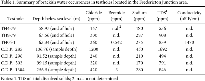
Display large image of Table 1
19 Four possible explanations for the origin of this brackish water: (1) road salt contamination, (2) dissolution of salt-rich bedrock, (3) saltwater intrusion from underlying saline ground-water linked to coastal marine source, and (4) relict seawater trapped from the late glacial marine incursion. The occurrence of bromide normally precludes the possibility that the brackish water results from road salt contamination as bromide is not typically part of the chemical composition for road salt (Snow et al. 1990). In those studies that were carried out (Table 1), Cl/Br ratios are closer to that typically found for seawater (in the vicinity of 289) than that commonly found for rock salt (>1200), as suggested by Snow et al. (1990). While road salt run-off could migrate into the North Branch Oromocto River, it would be further diluted by river water and infiltration before arriving at the supply wells. Local river levels, approximately 10 m above sea level, are well above the depths of saltwater occurrences at Fredericton Junction, indicating that migration of road salt to the aquifer from river recharge is an unlikely source of brackish water at present.
20 Webb (1981) suggested that pockets of saltwater were retained in the formation upon isostatic uplift following the last deglaciation. This conclusion was reached after examining and discounting, (a) possible sources of chloride from subsurface evaporates in Pennsylvanian strata, (b) subsurface evaporates in Mississipian strata, and (c) complex weathering reactions within Pennsylvanian strata.
21 Table 1 shows chemical and geophysical parameters that are typically associated with saltwater occurrences. The more elevated the parameter, the higher the influence of saltwater in that particular area of the formation. Examination of test borehole sampling depths and related end of borehole depths are quite variable. The groundwater sample depths range from 58.97 m to 256.5 m below sea level. If the source of the brackish water is from the underlying freshwater/saltwater interface, one would expect a much closer agreement in depth with the occurrence of saltwater (assuming a gradual landward-dip in the ‘ saltwater table'). In addition, the concentrations in Table 1 are more representative of brackish water than seawater and are probably derived from an interface zone of mixing. The wide variance in depths of brackish water would indicate either a freshwater/saltwater interface mixing zone of variable thickness, or the occurrence of discontinuous ‘ pockets' or ‘ islands' of saline-rich groundwater. Such saline-rich pockets could be the result of trapped accumulations from the Acadia Sea incursion. Mixing could also occur at the boundaries of saline pockets, thus both situations are feasible and could likely be distinguished by hydrogeological mapping and finite dating.
22 Gemtec Limited recently obtained a sample of saline water from a depth of approximately 45 m in fractured sandstone (Gemtec Limited, personal communication, 2006). The sample was recovered during drilling at Youngs Cove located approximately 65 km northeast of Fredericton Junction and 80 km north of the Bay of Fundy (see insert Fig. 1). Radiocarbon dating of the sample by the Isotrace Radiocarbon Laboratory at the University of Toronto returned a date of 7400 BP ± 70 years (Gemtec Limited, personal communication, 2006). The date is less than the expected age of 10 000 – 12 000 BP and is likely the result of mixing with younger formational water.
23 Two of the test holes from the 1979 drill program (TH4-79 and TH8-79; Fig. 2) as well as the 2005 test well (TH05-1; Fig. 2) drilled as part of the current groundwater exploration program intersected saline groundwater at depths (Jacques Whitford Environment Limited 2003). Brackish water in these wells occurs at depths of 58.97 m (TH4-79), 67.56 m (TH8-79) and 63.34 m (TH05-1) below sea level. The approximate level of the North Branch Oromocto River in the Fredericton Junction area is 10 m above sea level, or about 69 m higher in elevation than the reported findings of brackish water. Surface water quality monitoring from 1969 to 2002 at a sampling site on the North Branch of the Oromocto River at Tracy (Fig. 1) shows conductivity measurements in the order of 50 µSIE/cm (New Brunswick Department of Environment, unpublished data). Based on the low values of measured conductivity, it is reasonable to state that the North Branch Oromocto River is representative of a freshwater river system.
24 The occurrence of brackish groundwater at locations within a few 10's of kilometers from a sea coast as a result of saltwater intrusion is not unexpected. However, occurrences of saline groundwater at locations greater than 50 km from a sea coast, while common in the Carboniferous bedrock of New Brunswick (Webb 1981), may be due in part to pockets of remnant late glacial seawater. After consideration of the previous studies of glacial history and surrounding geology, we are inclined to agree with the conclusion of Webb (1981) that the saline water is a relict of glacial marine incursion. Although the maximum elevation remains unknown, Rampton et al. (1984) suggest that the area could have been inundated during the DeGeer Sea (about 12 400 BP) and Acadia Sea (about 12 000 BP), and submerged under both fresh and marine waters (Fig. 5). From examination of the mineralogy and geochemistry, Giudice (2005) concludeed that much of the sediment was deposited under fresh water conditions, possibly due to melting of surrounding ice masses at higher elevations.
25 Grant (in Seaman et al. 1993) suggested that after 14 000 BP isostatic uplift began to exceed the rate of eustatic sea level rise. By 10 500 BP relative sea level may have been close to the present mean sea level and it continued to fall until about 7000 BP when it reached an elevation approximately 37 m below present mean sea level (Seaman et al. 1993). The inland sea may have existed for a period of less than 2500 years and possibly for less time at locations experiencing rapid isostatic rebound. Yet this time would have been likely sufficient to enable sea water to displace any fresh water in the underlying bedrock. Webb (1981) suggested that the significant density contrast between seawater and freshwater, as well as the greater volume and greater hydrostatic saline groundwater head would have contributed to the freshwater displacement. Webb (1981) also noted that most of the brackish wells in New Brunswick are located in topographic depressions and are particularly common along river valleys overlying Carboniferous bedrock and emptying into coastal waters. These locations would form natural topographic traps for relict seawater.
26 It is likely that some expansion of the sedimentary bedrock porosity occurred during deglaciation. With removal of the glacier load and isostatic rebound, the underlying strata would fracture, opening new voids (cf. Broster and Burke 1990; Park and Broster 1996). This development of cavities would have increased the permeability of the bedrock and may have facilitated absorbency. Marine water entering these depressed basins, likely saturated the underlying rock at that time and/or created brackish water by mixing with freshwater from surrounding melting glaciers.
AQUIFER VULNERABILITY AND PROTECTION
27 An understanding of pathways for aquifer recharge is fundamental when identifying locations where the aquifer is most vulnerable to contamination. The mostly confined Lower Aquifer is recharged where bedrock is exposed at surface. One location of significance is bedrock exposed along the river bed of the North Branch of the Oromocto River in the immediate vicinity of Well 1 and Well 2 (Fig. 2 and Fig. 4). The Middle Aquifer, where present, is confined by the upper aquitard, a clay-silt layer. In the absence of the upper aquitard, the Middle Aquifer would be at risk of contamination from the surface. The Upper Aquifer is at most risk from surface activities as it is unconfined.
28 As the Lower (confined) Aquifer is the main water supply aquifer for the area, areas of recharge and exposures at surface are of great importance. Stratigraphy in all three production wells consists of the Lower (bedrock) Aquifer confined by the lower till aquitard (Fig. 3 and Fig. 6). As previously mentioned, the bedrock is exposed at surface along the riverbed near Well 1 and Well 2 (see Fig. 2). Given the proximity of the wells to the river (within 60 m) and the likelihood that the wells are hydraulically connected to the river (suggested by higher transmissivity values), any contamination in the river has the potential to be drawn into the production wells. Well 3 is not situated along the river bank and would therefore be less likely to be affected by river contamination (Fig. 2). Due to its setback from the river and lower well yield, it is likely not as connected hydraulically to the river as are Wells 1 and 2.
29 Post-glacial entrenchment from scouring along river beds has been noted elsewhere as a means by which a mostly confined aquifer can be exposed at surface (Broster 1998; Broster and Pupek 2001). At Fredericton Junction, borehole records reviewed by Giudice (2005) demonstrated that a channel, now buried and infilled with alluvial sand and gravel deposits, was incised into the till and clay-silt units (Fig. 7) in the vicinity of the village sewage lagoon (Fig. 2). The till unit (lower aquitard) was not found during drilling over a width of approximately 60 m (Fig. 7, locations TH2-79 and TH3-79) leaving only a few metres thickness of the clay-silt unit (upper aquitard) for protection of the underlying bedrock aquifer. If the upper aquitard is absent at other locations along the buried channel, potential contaminants might migrate along the channel and would have a direct pathway into the underlying aquifer (Broster and Pupek 2001).
Fig. 6 Stratigraphic cross-section of the upland area between TH05-1 and DW1 (Cross-section B'-B in Fig. 2), showing a continuous protective till cover confining the lower bedrock aquifer. DW1 is located approximately 150 m from the North Branch Oromocto River.
Display large image of Figure 6
30 Fredericton Junction is at or near capacity of well production and currently looking for additional water sources. At locations away from the river, transmissivity values for the bedrock are relatively low (20 to 37 m2/d). The higher transmissivity in bedrock near the North Branch Oromocto River suggests that this area would have greater potential for the location of a new production well.
31 Given the relatively low transmissivity of the bedrock (20 to 37 m2/d), one would expect that the development of a new production well would take place in close proximity to either branch of the Oromocto River or other surface water sources. Doing so would increase the possibility of locating a well with a good hydraulic connection to surface water, resulting in yields adequate to warrant the development of a municipal production well. Water quality would have to be closely monitored and examined for evidence of filtration through the bedrock, adequate to remove surface-derived pathogens.
CONCLUSIONS
32 The stratigraphy of unconsolidated sediments beneath Fredericton Junction consists of a glacial retreat sequence consisting of, from bottom to top, till, glacifluvial sand and gravel, glacilacustrine clay-silt, and a surface unit of alluvium. Bedrock underlying the study area is of sedimentary origin and comprises the Minto Formation that consists primarily of sandstone, conglomerate and siltstone of Carboniferous age (or younger). This bedrock comprises the Lower Aquifer and is considered the most promising in terms of locating municipal and domestic water supplies. Three aquifer units are present in parts of the valley; the Lower (sandstone supply) Aquifer, the Middle Aquifer of discontinuous glacifluvial sands and gravels, and the Upper Aquifer composed of surface alluvium and colluvium. The Middle and Upper Aquifers are most vulnerable to contamination from anthropogenic surface activities.
Fig. 7. Stratigraphic cross-section of the valley wall (Cross-section A'-A in Fig. 2) between boreholes TH1 and TH1-04. The lower half of the cross-section is approximately sub-parallel to the North Branch Oromocto River, approximately 100 – 150 m to the west. There is evidence that a channel infilled with alluvial sand and gravel deposits is incised into the surficial sediments at location TH3-79. The approximate location of the municipal sewage lagoon (Fig. 2) is between TH3 and TH1-79.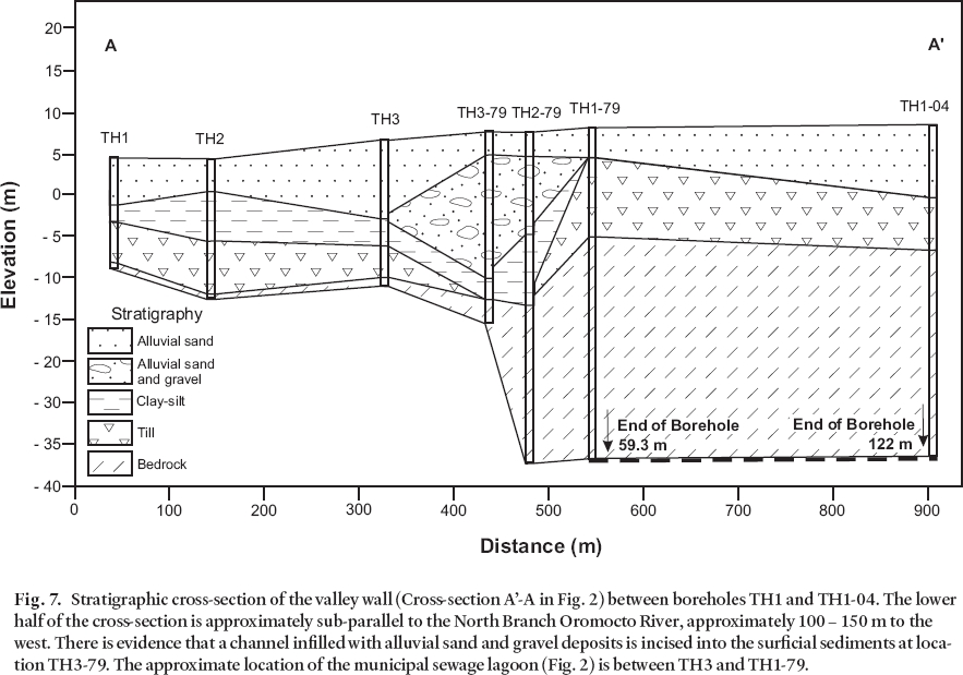
Display large image of Figure 7
33 Ground water is generally of good quality with the exception of iron and manganese which are considered more aesthetic concerns than health concerns. Also, pockets of brackish water occur in the Carboniferous strata, interpreted to be in part, remnant sea water from the Acadia Sea inundation following the retreat of the Late-Wisconsinan ice sheet more than 14 000 years ago. Road salt runoff is not contributing deleterious amounts of sodium chloride to the quality of the local ground water. However, future use of the up-stream watershed is a concern, particularly for agricultural compounds entering recharge zones.
34 The Lower (supply) Aquifer is vulnerable to contamination at its recharge areas, where it is exposed at surface, and where the confining lower aquitard is present in insufficient thicknesses or is absent. Some recharge areas at distal locations in the watershed may pose a future risk to the water supply as only identified recharge areas are protected under the New Brunswick Department of Environment's Wellfield Protection Designation Order (WfPADO) – Clean Water Act (New Brunswick Regulation 2000-47). Through this act, protected areas are established around municipal wellfields that govern land-use. While this may be adequate for protection of local groundwater systems within a few kilometers of a municipal supply well, it does not address problems associated with source areas for deeper regional groundwater systems.
35 Currently, groundwater from the aquifer is within acceptable limits of the Canadian Drinking Water Quality Guidelines, although this situation could be threatened by continued unrestricted exploitation and anthropogenic activity. The supply aquifer is also vulnerable to saline intrusion from uncontrolled extraction that could raise deeper brackish or saline water, although this scenario is not considered to represent a problem under the current rates of extraction.
36 The present study has implications for groundwater exploration and supply in glaciated estuarine valleys elsewhere. For example, it could be expected that occurrences of brackish groundwater would be found farther inland along valleys than for other areas of equal distance from a coast. Valleys that were glacially over-deepened and inundated would be probable sites for pockets of relict saline groundwater. Few studies have examined the correlation between glaciated estuarine valleys and the frequency of saltwater occurrence, or the implications to potable water extraction rates and land use in relation to these topographic features. In areas of former glaciated estuarine valleys, a thorough understanding of the nature of the geological and hydrogeological environment is fundamental to fully protect a potable water resource and to ensure its sustainability for the future.
ACKNOWLEDGEMENTS
The authors would like to thank Kenneth Burke, Dan Conohan, Shaun Pelkey, Darryl Pupek, and Clint St. Peter for advice and assistance during the earlier field work of the project; Jeff Stymiest for providing his GIS expertise and advice; and the municipal staff of the Village of Fredericton Junction for assistance during initial exploratory drilling as part of an initial study. The authors are especially grateful to Shaun Pelkey and Vernon Banks of Gemtec Limited for permission to include the results on radiocarbon analysis. Research and manuscript preparation was supported by financial assistance from the New Brunswick Department of Environment. Other sources of research support were provided by the Department of Natural Resources, Geological Survey Branch. Some of the data presented here represents part of a graduate project by Giudice. We also thank Ian Spooner and an anonymous reviewer for suggestions of improvement to an earlier manuscript.REFERENCES
ABP Consultants Limited. 1979. Groundwater Study Village of Fredericton Junction. New Brunswick Department of the Environment and Local Government, File Number 24165-0F04, Fredericton, New Brunswick, 41 p.
ABP Consultants Limited. 1979. Evaluation and Construction of Production Well for Fredericton Junction. New Brunswick Department of the Environment and Local Government, File Number 24165-0F04, Fredericton, New Brunswick, 28 p.
Broster, B.E. 1994. The significance of glaciation on engineering geology at Fredericton, New Brunswick. Geological Association of Canada, Abstracts and Program, A-14.
Broster, B.E. 1998.Aspects of engineering geology at Fredericton, New Brunswick. In Urban Geology of Canadian Cities, Edited by P.F. Karrow and O.L. White. Geological Association of Canada Special Paper 42, pp. 401– 408.
Broster, B.E., & Burke, K.B.S.B. 1990. Glacigenic postglacial faulting at Saint John, New Brunswick, Atlantic Geology, 26, pp. 125– 138.
Broster, B.E., & Park, A.F. 1993a. The application of Quaternary studies to mine development and control of acid mine drainage. Canadian Quaternary Association, Program with Abstracts and Field Guide, A7
Broster, B.E., & Park, A.F. 1993b. Dynamic glacigenic deformation of near-surface metamorphic bedrock: Heath Steel Mines, New Brunswick. Journal of Geology, 101, pp. 523– 530.
Broster, B.E., & Pupek, D.A. 2001. The significance of buried landscape in subsurface migration of dense non-aqueous phase liquids: the case of Perchloroethylene in the Sussex Aquifer, New Brunswick. Environmental & Engineering Geoscience, VII, pp. 17– 29.
Clark, G.S. 1962. Geological Notes Fredericton Junction, York, Sunbury and Queens Counties. New Brunswick Department of Lands and Mines, P.M. 61-3, 10 p.
Daigle, A.E. 2005. Stratigraphy and three-dimensional architecture of surficial sediments at Fredericton, NB. Unpublished M.Sc. thesis, University of New Brunswick, 163 p.
Freeze, A., & Cherry, J.A. 1979. Groundwater. Prentice-Hall Incorporated, Englewood Cliffs, New Jersey. 604 p.
Gadd, N.R. 1973. Quaternary geology of southwestern New Brunswick, with particular reference to Fredericton area. Geological Survey of Canada, Paper 71-34, pp. 1– 31.
Giudice, G.M. 2005. Implications of glacial stratigraphy to municipal planning in a glaciated valley: Fredericton, New Brunswick. Unpublished M.Sc. thesis, University of New Brunswick, 137 p.
Godfrey Associates Limited 1996. Well Drillers Reports Fredericton Junction, N.B. Project No: 038-003. Saint John, New Brunswick. 6 p.
Hamilton, J.B., & Carroll, D.J.J. 1975. Sand and gravel in New Brunswick. ). New Brunswick Department of Natural Resources, Mineral Resources Branch, Report of investigation No. 16, 107 p.
Health Canada. 1996. Guidelines for Canadian Drinking Water Quality. 6th ed. Canada Communications Group – Publishing, Ottawa, Canada. 90 p.
Jacques Whitford Environment Limited. 2003. Draft Report Production Well Rehabilitation Fredericton Junction, New Brunswick. Fredericton, New Brunswick. 28 p.
LeBlanc, F., & Lloy, S. 2003. Preliminary Performance Survey Final Report – Barrier Summary Village of Fredericton Junction. New Brunswick Department of the Environment and Local Government, Stewartship Branch. 7 p.
Neill and Gunter Limited. 2004. Fredericton Junction Borehole (TH1-04) Log. Fredericton, New Brunswick. 4 p.
Neill and Gunter Limited. 2005. Fredericton Junction Borehole (TH05-1) Log. Fredericton, New Brunswick. 4 p.
New Brunswick Department of the Environment and Local Government. 2000. Wellfield Protection Designation Order (WfPADO)– Clean Water Act (New Brunswick Regulation 2000-47). Fredericton, New Brunswick, Canada. 24 p.
New Brunswick Department of the Environment and Local Government. 2003. Domestic Water Well Database. Fredericton, New Brunswick, Canada.
Park, A.F., & Broster, B.E. 1996. Influence of glacitectonic fractures on wall failure in open excavations: Heath Steele Mines, New Brunswick, Canada. Canadian Geotechnical Journal. 33, pp. 720– 731.
Rampton, V.N., Gauthier, R.C., Thibault, J., & Seaman, A.A. 1984. Quaternary Geology of New Brunswick. Geological Survey of Canada, Memoir 416. 77 p.
Roy, K.K., & Elliott, H.M. 1980. Resistivity and IP Survey for Delineating Saline Water and Fresh Water Zones. Geoexploration, 18, pp. 145– 162.
Seaman, A.A., Broster, B.E., Cwunar, L.C., Miller, R.F., & Thibault, J.J. 1993. Field Guide to the Quaternary Geology of Southwestern New Brunswick. New Brunswick Department of Natural Resources, Mineral Resources Branch, Open File Report 93-1, 102 p.
Snow, M.S., Kahl, J.S., Norton, S.A., & Olson, C. 1990. Geochemical Determination of Salinity Sources in Groundwater Wells in Maine. In Proceedings of the Focus Conference on Eastern Regional Ground Water Issues, Groundwater Management #3, pp. 313– 327.
Subsurface Surveys. 1976. Soils Investigation N.W. Oromocto River Bridge No. 1, Sunbury County, N.B. Fredericton, New Brunswick. 10 p.
Thibault, J. 1981. Granular aggregate resources of Fredericton Junction (NTS 21 G/10). New Brunswick Department of Natural Resources, Mineral Resources Branch, Open File 81-5.
United States Geological Survey (USGS). 2000. USGS Earth Resources Observation System Data Center. Shuttle Radar Topography Mission (SRTM) Data (ftp: //edcgs9.cr.usgs.gov/pub/data/srtm).
Webb, T.C. 1981. Origin of Brackish Formation Ground Waters in the Pennsylvanian of New Brunswick. Natural Resources New Brunswick Open File Report 82-5, 24 p.
Editorial responsibility: Donald L. Fox