Articles
The geology and hydrogeology of springs on Cape Breton Island, Nova Scotia, Canada:
an overview
doi:10.4138/atlgeol.2019.004
ABSTRACT
Cape Breton Island springs have historically played a role in developing potable water supplies, enhancing salmonid streams, creating thin-skinned debris flows, as well as mineral and hydrocarbon exploration. Cape Breton Island provides a hydrogeological view into the roots of an ancient mountain range, now exhumed, deglaciated and tectonically inactive. Exhumation and glaciation over approximately 140 Ma since the Cretaceous are of particular relevance to spring formation. A total of 510 springs have been identified and discussed in terms of hydrological regions, flow, temperature, sphere of influence, total dissolved solids, pH and water typing. Examples are provided detailing characteristics of springs associated with faults, karst, salt diapirs, rockfall/alluvial systems and debris avalanche sites. Preliminary findings from a monitoring program of 27 springs are discussed. Future research should focus on identifying additional springs and characterizing associated groundwater dependent ecosystems. Incorporating springs into the provincial groundwater observation well monitoring program could facilitate early warning of drought conditions and other impacts associated with changing climate.
RÉSUMÉ
Les sources de l’île du Cap-Breton ont toujours joué un rôle important dans l’approvisionnement en eau potable, l’amélioration des cours d’eau fréquentés par les salmonidés, la création de coulées de débris recouverts de till et l’exploration de minéraux ou d’hydrocarbures. L’île du Cap Breton procure un aperçu hydrogéologique des racines d’une ancienne chaîne de montagnes, maintenant exhumée, érodée par la glaciation et tectoniquement inactive. L’exhumation et la glaciation survenues il y a environ 140 Ma depuis la période crétacée sont d’une importance particulière pour la formation de sources. Au total, 510 sources ont été identifiées et analysées en ce qui a trait aux régions hydrologiques, aux flux, aux températures, aux sphères d’influence, aux matières dissoutes totales, au pH et à la typologie de l’eau. Des exemples précisent les caractéristiques de sources associées aux failles, karsts, diapirs de sel, chutes de pierres, systèmes alluviaux et sites d’avalanches de débris. Les premières conclusions d’un programme de surveillance portant sur 27 sources sont en train d’être examinées. La recherche future devrait porter sur l’identification de sources supplémentaires et la caractérisation d’écosystèmes tributaires des eaux souterraines. L’intégration des sources au programme de surveillance des puits d’observation d’eaux souterraines pourrait faciliter la fonction d’alerte précoce lors de conditions de sécheresse et d’autres répercussions associées au changement climatique.
[Traduit par la redaction]
INTRODUCTION
1 Over the last two decades recognition of the importance of springs has been growing. The field of ecohydrology (Larsen et al. 2012) has recognized springs as biodiversity hotspots (Sada and Pohlmann 2002; Cantonati et al. 2015), keystone groundwater dependent ecosystems (Springer et al. 2015; Cantonati et al. 2016; Cantonati et al. 2015; Brunke and Gonser 1997), and refugia for rare or unique aquatic and terrestrial life, including ecosystem goods and services species (Stevens et al. 2011; Nichols et al. 2014). Concerns over climate change impacts to spring dependent ecosystems were noted by Klove et al. (2013) and Asjarvi et al. (2015). Springs act as a “canary in the coal mine” for groundwater health (Alley and Alley 2017).
2 In other aspects trace element geochemistry of spring waters has been used to assess mineral potential (Caron et al. 2008). Hot springs have been used to aid in understanding geothermal systems (Renaut and Jones 2003, Curewitz and Karson 1997). In remote areas springs provide a relatively inexpensive resource to assess regional hydrogeology (Manga 1999). The role of groundwater as an erosive agent through seepage and icings can be important in shaping major landscape features (Nash 1996; Otton and Hilleary 1985; Baker et al. 1990). Springs occurring on continental shelves during Pleistocene low sea level stands are now submerged and recognized as fresh submarine groundwater discharge (SGD) zones, which are important features in managing coastal aquifers and nearshore marine environments (Faure et al. 2002; Fleury et al. 2007; Dimova et al. 2011; Taniguchi et al. 2002; Bakalowicz et al. 2007). Large magnitude terrestrial springs are often regarded as geologic wonders enhancing tourism (Florea and Vacher 2006).
3 In the early 1900s the documentation and classification of springs began in earnest by the United States Geological Survey (Alfaro and Wallace 1994). A spring inventory system is in use in parts of the United States (Sada and Pohlmann 2002). In Canada Alberta appears to be in the forefront of spring inventory, monitoring and research (Alberta Geological Survey 2017), especially on thermal springs in the southern Cordillera (Grasby and Hutcheon 2001; Grasby and Lepitzki 2002; Borneuf 1983).
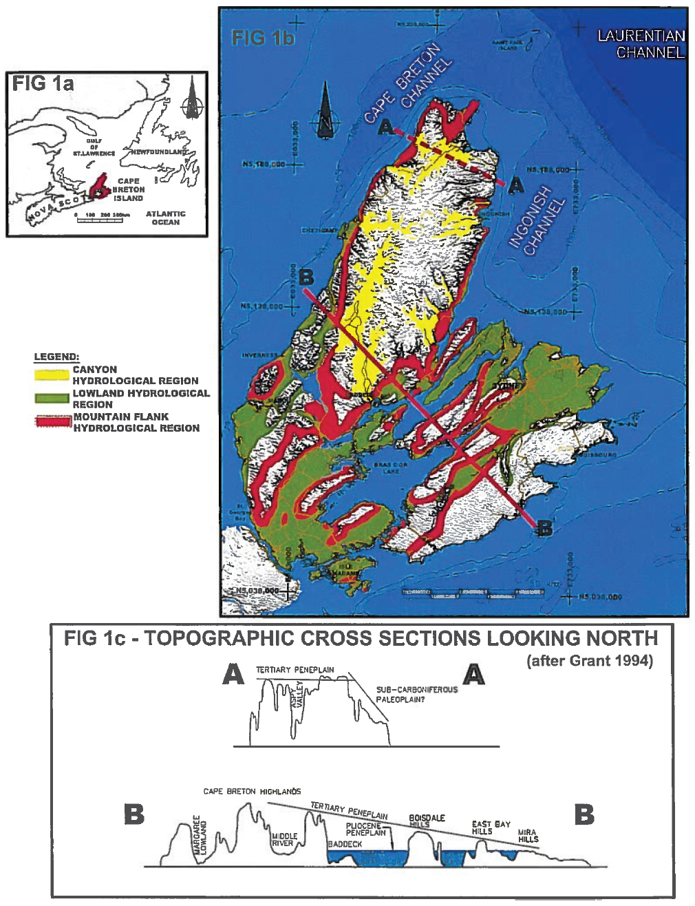
4 Cape Breton Island forms the northeastern part of the Province of Nova Scotia, along the Atlantic seaboard of Canada (Figs. 1a, b). It encompasses an area of approximately 11 700 km², making it the 18th largest island in Canada and 77th largest in the world. It is surrounded by the Atlantic Ocean on the east and the Gulf of St. Lawrence to the north and west. It is separated from mainland Nova Scotia by the Strait of Canso.
 Display large image of Figure 1
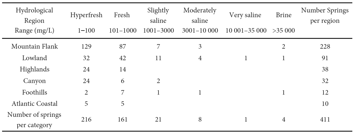
5 The authors’ experience indicate that Cape Breton Island springs have played a role in: (1) developing potable groundwater supplies for communities and individuals, (2) supplying bottled water operations, and (3) enhancing important salmonid streams. European medicinal beliefs were associated with springs at Glengarry, Bras d’Or, Cheticamp, Grande Anse, and L’Ardoise (Cross and Goyette 2000). The oil fields of Cape Breton Island in the Lake Ainslie area were first noted as hydrocarbons in springs (McMahon et al. 1986). The importance of springs in creating thin-skinned debris flows, with impact on transportation corridors and riverine systems in Cape Breton Island, were identified by Grant (1994), Wahl et al. (2007) and Finck (1993).
6 There has been no detailed, government assessment of springs in the province. Preliminary screening was undertaken privately by Cross and Goyette (2000); who identified 51 springs in Cape Breton Island. In Nova Scotia regional water resource evaluations have not focused on springs. It is therefore expected that this research will fill an important gap in understanding the island’s fresh water resources.
7 This paper represents the sixth in a series focusing on what is presently understood about CBI’s fresh water resources, to aid in their effective utilization and management. Previous papers in the series discuss: hydrological settings (Baechler and Baechler 2009), karst (Baechler and Boehner 2014), the impact of a changing climate (Baechler 2014), fault aquifers (Baechler 2015), and buried bedrock valley aquifers (Baechler 2017).
8 Springs are defined for this paper as ecosystems in which groundwater reaches the Earth’s surface, either at or near the land-atmosphere interface, or land-water interface (Springer and Stevens 2009).
9 A brief discussion of paleohydrology is followed by a description of the hydrological setting of the Island. A discussion of the spatial distribution of springs, as well as their physical and chemical characteristics, is provided, along with a more detailed discussion of five different spheres of influence (SOI). The final section documents the development and preliminary results of a spring monitoring program.
PALEOHYDROLOGY
10 Cape Breton Island’s circa 1 Ga geological history created a complex, lithological and structural terrain through plate collision, mountain building, regional scale faulting, sedimentary basin formation, karstification, opening of the Atlantic Ocean, prolonged exhumation, glaciation, and variable sea level; now molded by a maritime climate, surrounded by the sea. Exhumation and glaciation over approximately 140 Ma since the Cretaceous are of particular relevance to the formation of springs.
11 The crystalline basement rocks of the island were created through six orogenic cycles, spanning approximately 1200 to 65 Ma (e.g., van Staal and Barr 2012). These events raised the Appalachian mountain belt along the eastern margin of the North American continent, in which CBI is positioned. Erosion of the mountain complex resulted in formation of the Maritimes Sedimentary Basin which overlies the crystalline basement.
12 Mesozoic erosion created a broad, lowland peneplain of the Appalachian mountain chain (Pascucci et al. 2000). During the Tertiary (65 to 3 Ma) the Mesozoic peneplain was uplifted and tilted to the east (Nova Scotia Museum 1997). During the subsequent erosional cycle, resistant crystalline basement rocks became more prominent in the landscape, as the surrounding softer sedimentary rocks created the lowlands. Grant (1994) noted that this exhumation provided the island’s landscape with two dominant planation surfaces (Fig. 1c). The Tertiary peneplain slopes southeast and maintains its identity as a geomorphic feature across the entire island from the western Cape Breton Highlands at an elevation of over 500 m, to the eastern coast at 30 m. It allowed for karstification, deep weathering and incision by a remarkable dendritic system of gorges and canyons, assumed to predate the last glaciation. A Pliocene peneplain comprises a network of interconnected lowlands ranging from 10 to 200 m elevation, developed mainly on Carboniferous sedimentary rock.
13 The landscape of the island had therefore largely assumed its present form by pre-Quaternary time. This created strong landscape contrasts which influenced the course of Quaternary glaciation (Nova Scotia Museum 1997). Glaciation modified the landscape, with scouring and deposition of a wide range of glacial debris from low permeable glacial tills and lacustrine deposits to permeable glacial fluvial outwash sands/gravels, alluvial fans, and talus cones, coupled with karst development. The last remnants of Wisconsinan ice disappeared from the Island circa 10 ka, leaving sea level approximately 50 m lower than present day. It is this final landscape which now drives the present-day groundwater flow systems and spring development.
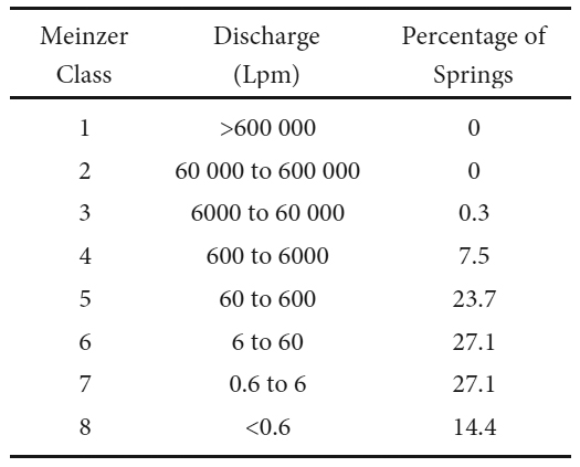
14 In summary CBI provides ample opportunity for the formation of springs, due to a coupling of an exhumed Mesozoic paleosurface and Quaternary glaciation.
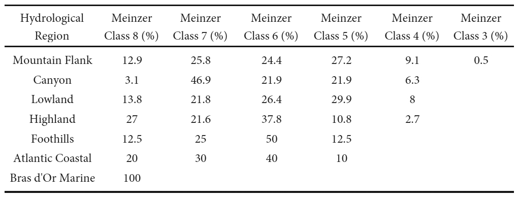
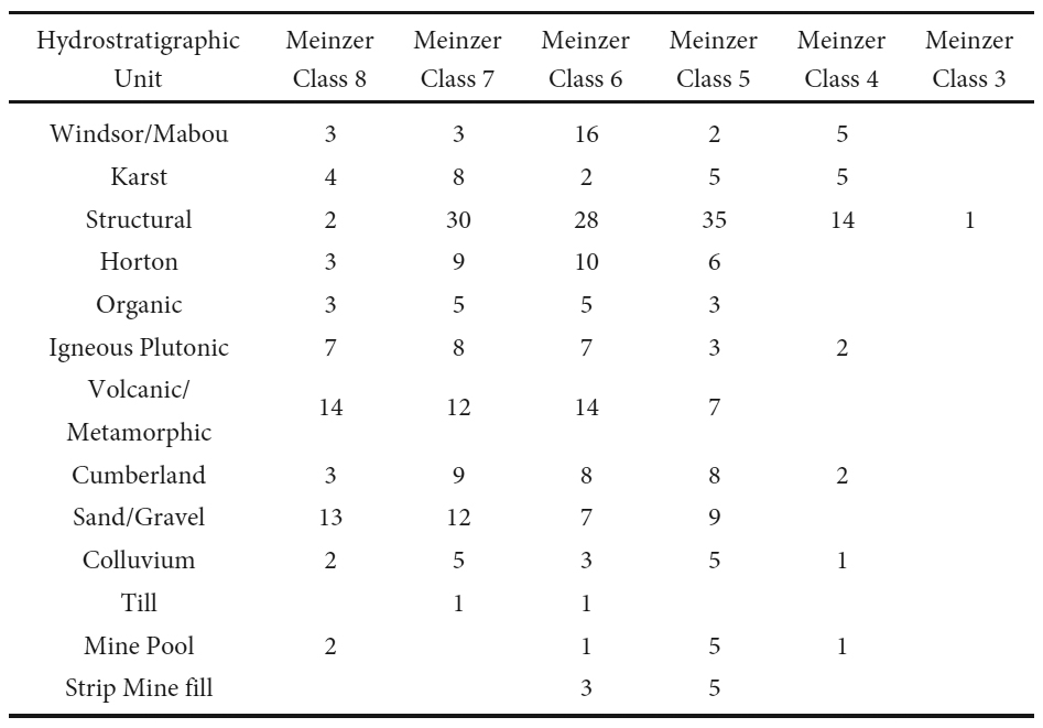
PRESENT DAY HYDROLOGICAL SETTING
15 The Island has a temperate, humid, continental climate, with a 30-year climatic normal (1981–2010) annual precipitation of 1517 mm and mean annual air temperature of 5.9°C. These conditions provide for an estimated annual water surplus and deficit using the Thornthwaite method (Thornthwaite 1948) of 987 and 21 mm, respectively. Based upon a moving decadal means analysis (Baechler 2014) the Island’s climate is changing with a decline in total annual precipitation of approximately 300 mm, and a rise in mean annual air temperature of 0.8°C since the early 1980s.
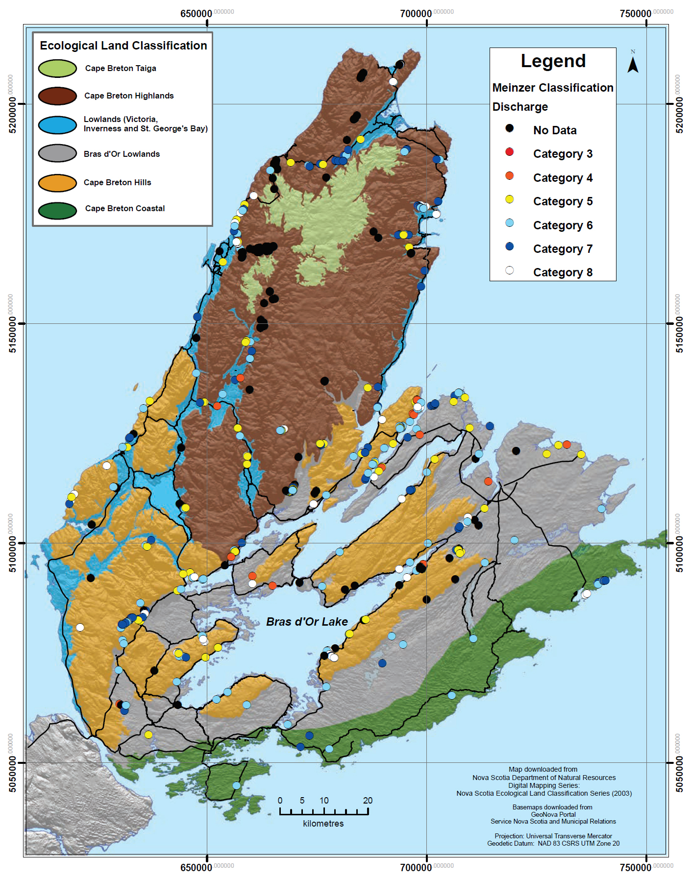
16 Sharpe et al. (2014) positioned CBI regionally in both the Appalachian and Maritimes Basin hydrogeological regions. Baechler and Baechler (2009) locally mapped six hydrological regions over the island (now expanded to nine) by defining areas with characteristic types, numbers and orientations of hydrostratigraphic units (HUs), climate, topographic relief, and forest cover. While the delineation of hydrological regions (Fig 1b) is more applicable, the provincial ecological land classification system (Neily et al. 2017), as noted in Fig. 2, is more commonly in use. The Lowland, Mountain Flank and Canyon Hydrological regions are particularly relevant to the discussion of springs. The Lowland Region coincides with the Carboniferous Lowland of the Ecological Land Classification. The Mountain Flank and Canyon hydrological regions have no similar unique, ecological counterpart, but instead include portions of the Highlands, Avalon Uplands and Carboniferous Lowlands.
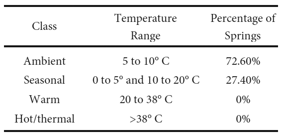
 Display large image of Figure 2
17 The Mountain Flank Hydrological Region encompasses approximately 13% of the Island. It incorporates the steep transition slopes of up to 400 m in relief with slopes of 20 to >75%, between Lowland and Highland regions. It exhibits the most complicated hydrological settings including hydraulically active, strike-slip, dip slip, thrust and normal faults. It is bedrock controlled, with minimal cover of glacial materials. Localized overburden is composed of thick colluvium, in the form of talus rock slopes, alluvial fans and kame terraces.
18 The Canyon Hydrological Region, encompassing 8% of the Island, is incised into the crystalline rocks comprising the highland Tertiary peneplain, along large-scale fault systems in various stages of exhumation and hydrogeological development (Baechler 2015). Coarse unconsolidated sediments underlie the valley floors, associated with glacial-fluvial, colluvium, and alluvial fan deposits.
19 The Lowland Hydrological Region on Cape Breton Island covers approximately 24% of the Island and is developed over the Pliocene peneplain. The region is underlain by a variety of clastic sedimentary bedrock, coal cyclothem sequences and evaporites. Karst is present in various stages of hydrogeological development (Baechler and Boehner 2014). The relief is generally bedrock controlled with a thin veneer of glacial till, resulting in a smooth, undulating terrain with low relief knolls and valleys. A number of broad lowland valleys are underlain by glacial-fluvial deposits in floodplains and buried bedrock valley aquifers (Baechler 2017), which can be underlain by evaporites and argillaceous clastics of the Windsor Group, or arenaceous clastics of the Cumber-land or Horton groups.
CAPE BRETON ISLAND SPRINGS
20 The springs identified in this paper encompass natural sites, as well as those where natural flow has been exposed by man-made activities (e.g. overflowing wells, mine pools, road cuts, and quarry exposures). The focus of this paper is on those springs noticed during dry weather events, not those only active during storm runoff. Most springs have only been visited once and therefore represent varying seasonal and weather conditions, making statistics more subjective. Twenty-seven springs of varying types were selected for long term monitoring to improve the understanding of the impact of weather and climate change.
21 Sada and Pohlmann (2002) noted that a spring inventory includes four levels: (1) data mining to review existing information, (2) reconnaissance field surveys, (3) detailed field surveys, and (4) development of a digital database. This paper focuses on the physical and chemical aspects of items 1, 2, and 4.
22 The authors have been collecting spring data during self funded research over CBI for 15+ years. The spatial distribution of the data set is not random, as spring identification has usually been through field work conducted for other purposes. The dataset supporting this paper provided information for 510 sites on CBI (Fig. 2), including 42 identified by Cross and Goyette (2000). A total of 27 are used for potable water supplies. It also includes 68 debris avalanches sites, 32 of which were previously identified by Finck (1993) and Wahl et al. (2007). The remaining 36 sites were identified by reviewing air photos for evidence of debris avalanche sites.
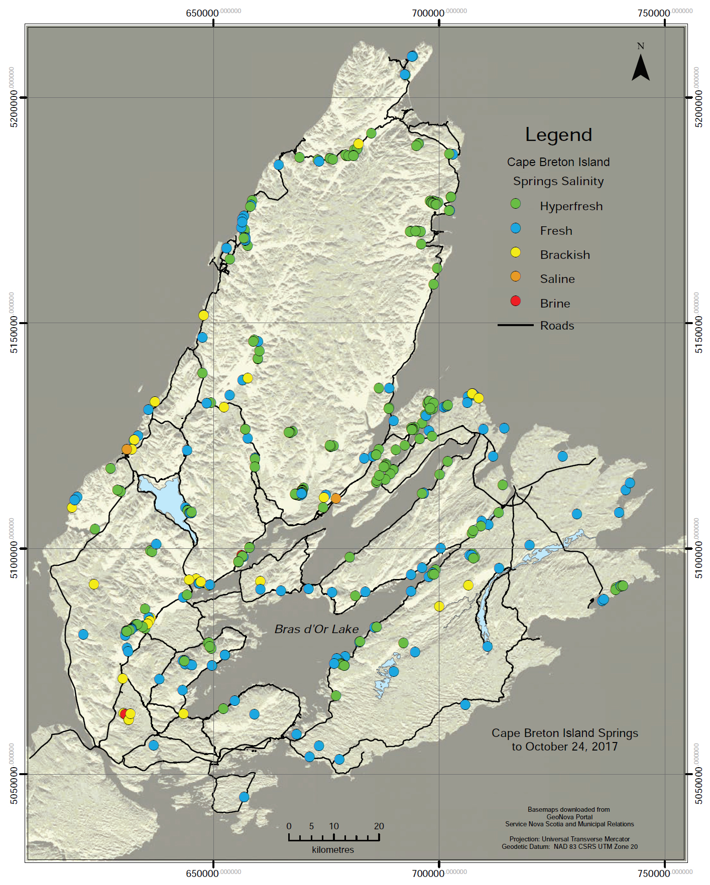
23 Data collection parameters included coordinates of spring discharge sites using a hand-held GPS, site photographs and measurement of flow, specific conductance and temperature. At select sites samples were collected for chemical analysis and/or data loggers were deployed. Debris avalanche sites were not field inspected due to remoteness. The groundwater dependent ecosystems (GDE) aspects of springs have not been addressed. All data have been entered into a Geographic Information System (GIS) digital database, which includes up to 37 separate pieces of information for each spring; expanding to a maximum of 89 if a complete chemical analysis was performed. A total of 142 springs (31%) have at least one chemical analysis. The datasets developed for this paper have been provided to the Nova Scotia Department of Energy and Mines for inclusion within their provincial water resources database.
24 Springs may be classified on the basis of diverse physical, chemical, biological and socio-cultural indicators; however, no system is perfect (Otton and Hilleary 1985; Cantonati et al. 2016; Springer and Stevens 2009; Alfaro and Wallace 1994). For this paper six indicators have been utilized, including: discharge, temperature, sphere of influence, total dissolved solids, pH and water type. The relationship between the 510 springs and their hydrological region are summarized in Figure 3.
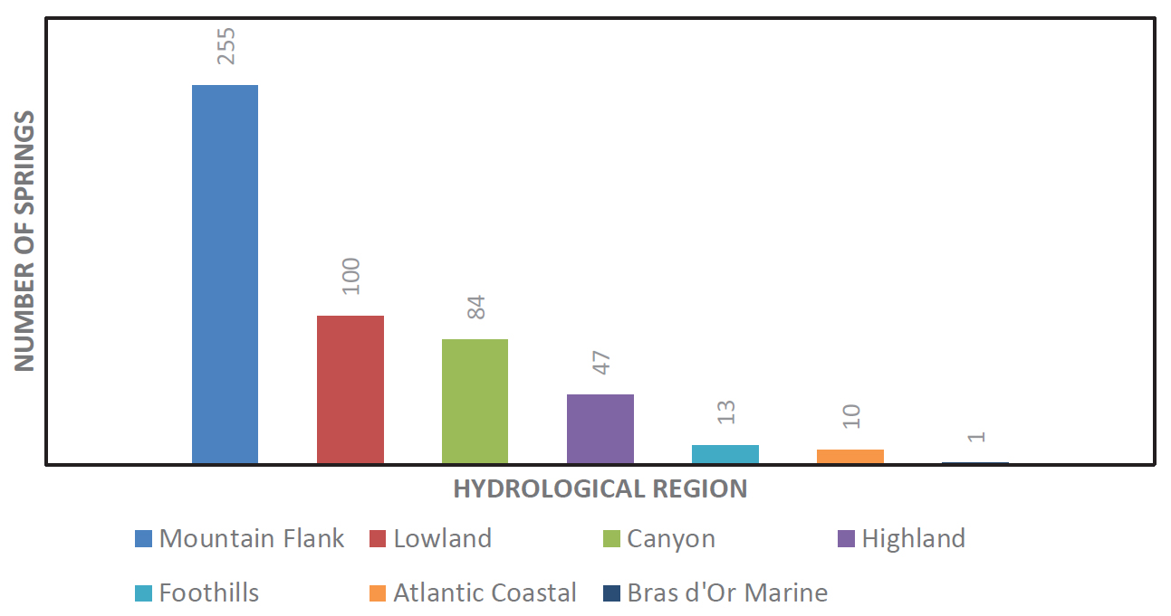
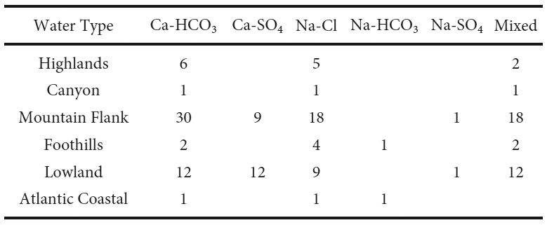
25 Although springs were found throughout all hydrological regions, the majority (50%) were found in the steep slopes of the Mountain Flank Region. The Lowland and Canyon regions exhibited similar percentages comprising a total of 36.1% of the springs.
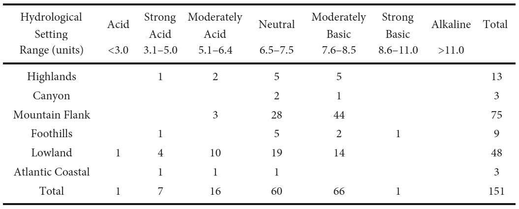
Discharge
26 The Meinzer (1923) classification system was utilized to describe discharge. The lowest is Category 8 set at less than 0.6 litres per minute (Lpm). This category is used to characterize seepages (Perez 2001).
27 The range in discharge associated with 384 springs with at least one flow measurement, encompassing a variety of seasons, is summarized in Table 1 and Figure 2. Their relationship to hydrological region is provided in Figure 3 and Table 2, as well as to hydrostratigraphic unit in Figure 4 and Table 3.
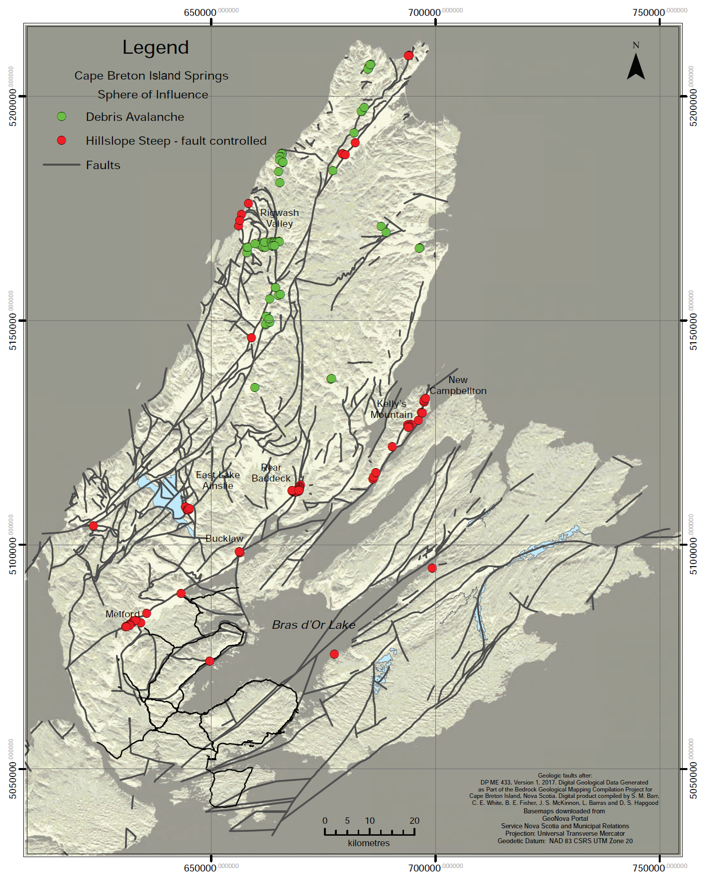
 Display large image of Table 3
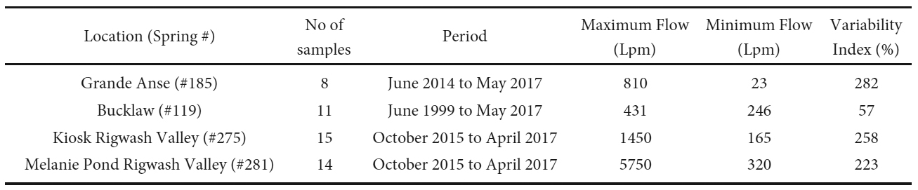
28 No magnitude 1 or 2 springs have been identified to date. The largest magnitude spring was Class 3, being a combination of flows from four closely spaced springs, with an instantaneous discharge of 7140 Lpm during spring runoff. Twenty-nine Class 4 springs were detected, with flows ranging between 600 to 3030 Lpm. The Class 5, 6 and 7 springs accounted for 77.9% of all reported springs, in roughly equal proportions. Class 8 (or seepages) accounted for 14.4% of those monitored. The largest magnitude Class 3 spring and 65.5% of all Class 4 springs occurred within the Mountain Flank Region.
29 Higher permeability fault zones and karstic limestone are regarded as zones of greater permeability and can result in concentration of high yield springs (Alfaro and Wallace 1994; Buczynski and Rzonca 2011; Sanders et al. 2010). Both hydraulically active faults (Baechler 2015) and karst in limestone, evaporites and marbles (Baechler and Boehner 2014) occur on the Island. In terms of faults, a number of springs have been found associated with strike slip, normal and thrust faults at Kelly’s Mountain, Rear Baddeck, Rigwash Valley, and the North Aspy River. The one Class 3 spring was associated with faults in the Structural HU. The Class 4 springs were associated with both the Structural and Karst HUs, with the largest discharge associated with faults at Baddeck and Kelly’s Mountain. Karst springs were generally in the lower Class 6 to 7 Meinzer categories. This is expected to be a result of infilling of karst features with glacial debris during the last glaciation.
Temperature
30 Spring temperatures are described in relation to “hot” or “cold”, which at times can be based upon the mean annual air temperature of the region being assessed, which varies with location (Van Everdingen 1972; Otton and Hilleary 1985). Due to lack of consistency in current definitions the terms should always be accompanied by the temperature range and benchmarks used (Pentecost et al. 2003). For the purposes of this analysis, spring water temperature was classified according to Table 4.
 Display large image of Table 4
31 Single temperature measurements were available for 394 springs (77% of the database). The recorded temperatures were mainly in the ambient range. The ambient range of 5 to 10°C was based upon consideration of: (1) the 5.9°C 1981–2010 normal mean annual air temperature of the Island from Environment Canada’s Sydney A station and (2) crustal temperature depths within the active groundwater flow field on the Island, which are predicted to be in the range of 6 to 10°C for depths to 150 m and increasing to 10 to 12°C down to 200 m (Grasby et al. 2009).
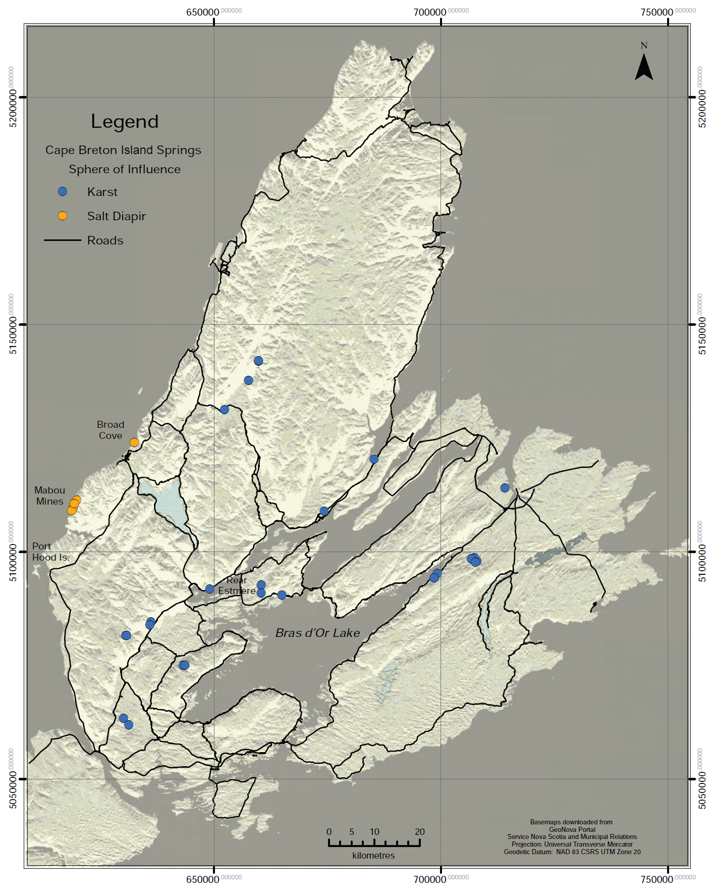
32 The extent of seasonal fluctuations was based upon 1981–2010 normal monthly mean daily air temperature values ranging from -5.9° to 18.0°C. The temperature of overflows from spring fed pools and small lakes exhibited even higher peaks, with instantaneous seasonal temperatures in the 20° to 25°C range (e.g., Melanie Pond, Dalem Lake and Sugar Camp Lake).
33 No warm or hot springs have been identified to date. Western Canadian studies have used 10°C above mean annual air temperature as defining hot springs (Grasby and Hutcheon 2001; Ferguson and Grasby 2011). Given that the temperatures of shallow springs and spring fed lakes are impacted by seasonal changes in air temperatures, and often exceed 10°C, the analysis for this paper utilizes body temperature (36.7°C) as a threshold to define hot springs, irrespective of altitude or pressure, as recommended by Pentecost et al. (2003).
34 Spring temperatures respond to both solar energy and crustal heat flow. Drury et al. (1987) noted that crustal heat flow varies across the Canadian Appalachians, being lowest in the Carboniferous Magdalen sedimentary basin, which surrounds and underlies the Lowland Hydrological Region of CBI. Up to 10 km of crust may have been eroded from the basement prior to basin formation, removing much of the radiogenic source of heat. Three geothermal flux measurements from CBI produced low values of 55 to 63 mW/m². In addition, crustal backgrounds may be affected by the presence of intrusive magma, volcanism, heat from radioactive elements and heat generated by friction along faults (Alfaro and Wallace 1994); none of which are known to exist on the Island. The distribution of hot springs in other areas can be related to hydraulically active faults (Grasby and Hutcheon 2001) or karstification (Hilberg and Kreuzer 2013) that provide high permeability flow paths for deep circulating, thermal meteoric waters. Although the island has hydraulically active, large fault systems (Baechler 2015) and karst systems (Baechler and Boehner 2014), the absence of thermal springs identified to date may be attributed to low crustal heat flows.
35 Of note is that geothermal gradients associated with sub-sea coal mine workings in the Sydney coalfield indicated temperatures of 20°C at 600 m depth (Forgeron personal communication 2018). Overflow mine pool springs in the Sydney area, however, exhibited consistent temperatures in the flooded Gardiner and Franklyn sites in the ambient range (averaging 7.6 and 8.1°C, respectively).
Spheres of influence
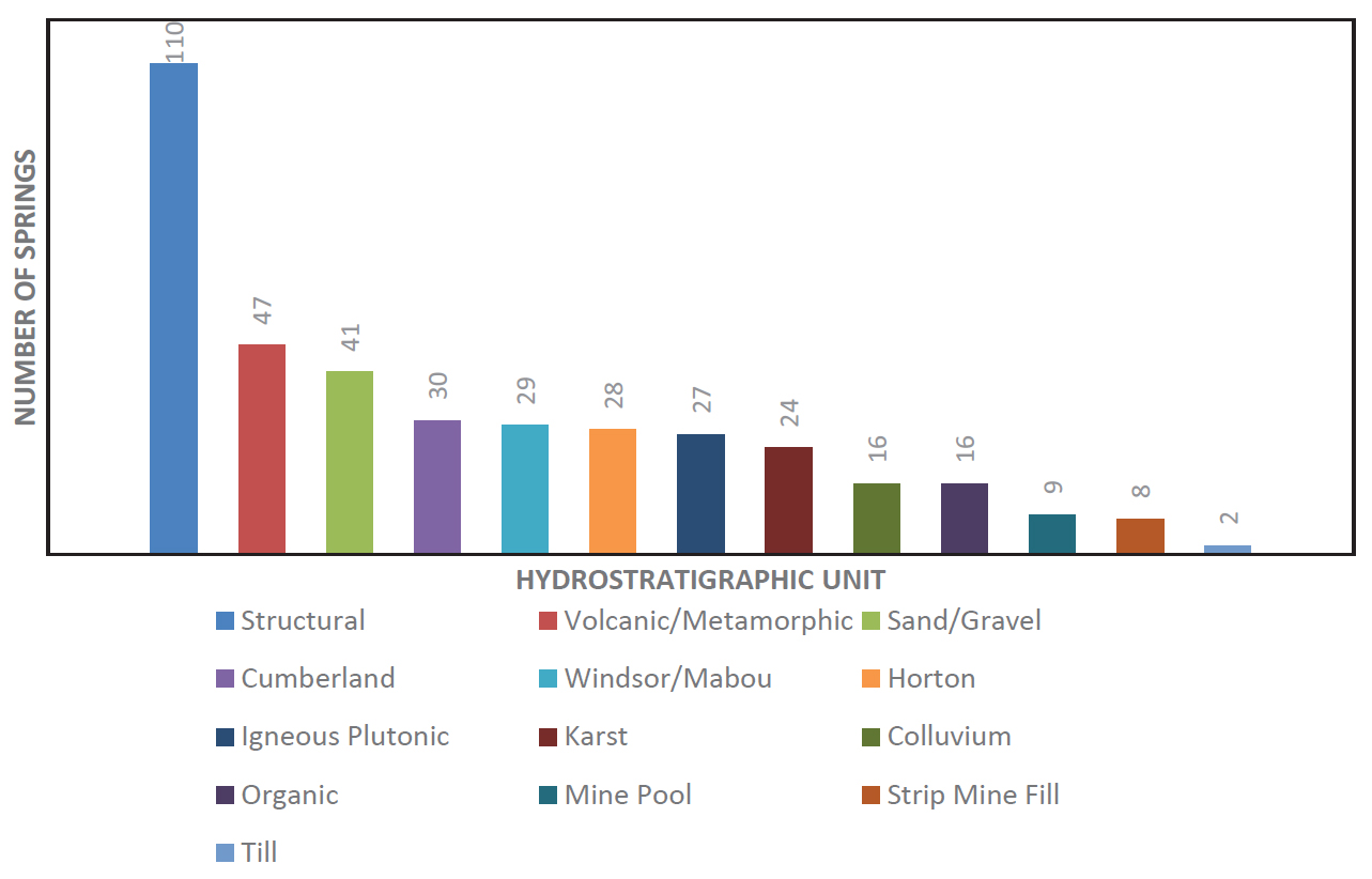
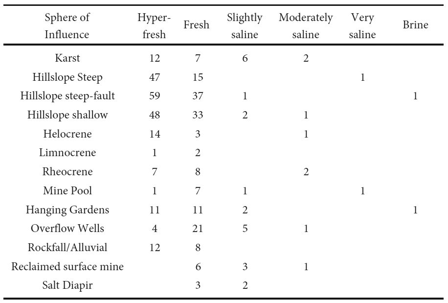
36 Springer and Stevens (2009) identified 12 spheres of influence (SOI) into which springs are discharged. This list was expanded to 19 SOIs (Table 5) to capture the variability of Cape Breton Island springs. The number of springs within each category is outlined in Figure 5. SOIs were determined from existing bedrock and surficial geological mapping, coupled with visual field inspection. Defining the primary SOI was difficult since in some cases multiple SOIs applied and the underlying geology was unknown.
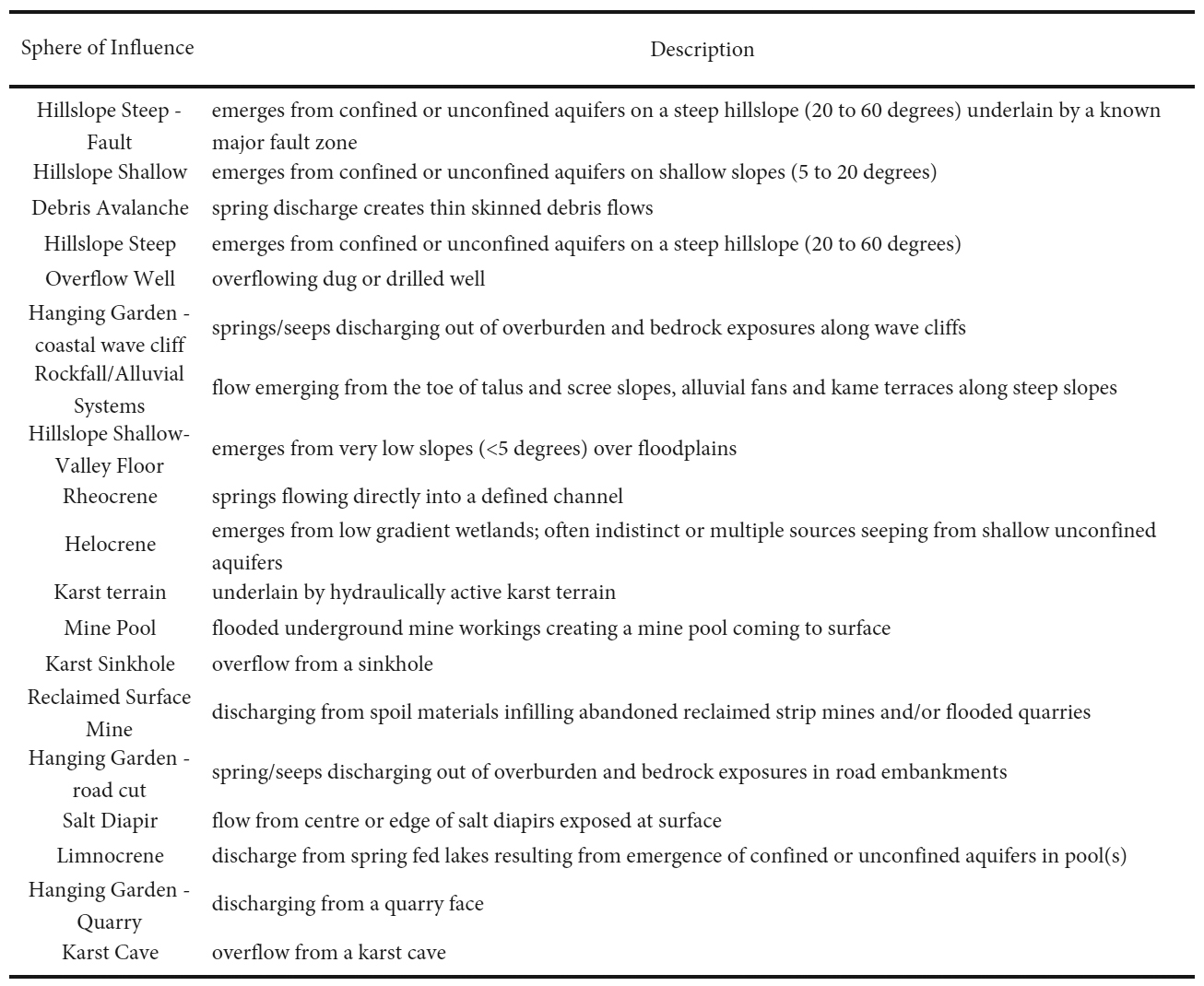
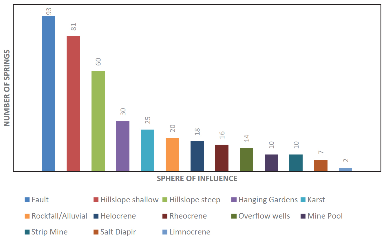
37 The largest number of springs is related to faults (20.6%). The next three most common SOIs have similar percentages (13 to 13.5%), relating to shallow and steep slopes, as well as debris avalanches. Given the difficulty in defining the underlying geology it is possible that some of the Hillslope steep springs may be fault controlled. The relationship between SOI and discharge is presented in Figure 5 and Table 6. The highest discharges (categories 4 and 3) are related to faults and karst, with the next highest discharges associated with the rockfall/alluvial systems. The karst and hillslope SOIs exhibit a large variability in discharges with Meinzer classes ranging from 8 to 4.
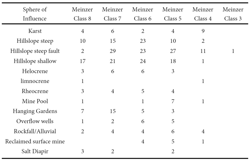 Display large image of Table 6Note: Karst includes karst sinkhole, cave, and terrain; Hillslope Shallow includes those on valley floors; Hanging Gardens includes
wave cliff, road cuts, and quarries.
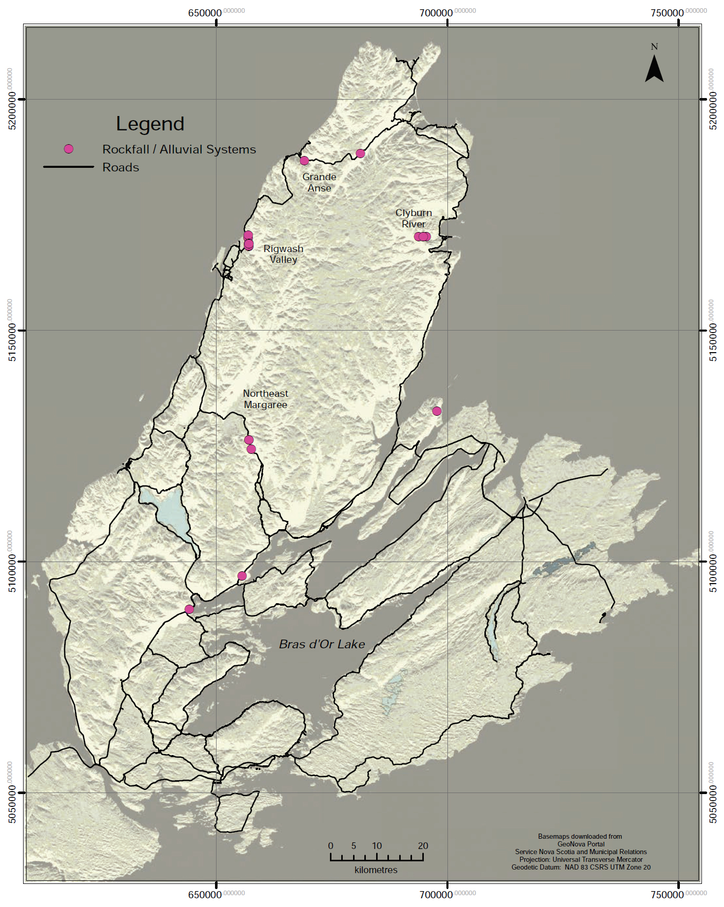
Display large image of Table 6Note: Karst includes karst sinkhole, cave, and terrain; Hillslope Shallow includes those on valley floors; Hanging Gardens includes
wave cliff, road cuts, and quarries.
Chemistry
38 Specific conductance (SC) is utilized as the primary chemical indicator for total dissolved solids (TDS). There is a range of conversion factors in the literature (Hem 1985) depending upon the nature of the solutes. Hem (1985) gives a range between 0.55 to 0.75 x SC. The 114 samples from this spring data set with both TDS (ranging from 13 to 73,000 mg/L) and SC provided a mean of 0.59 and median of 0.57. which agrees with that found for other areas of the province (J. Drage and G. Kennedy, personal communication 2018). For the purpose of this paper a 0.6 conversion factor was employed. A total of 411 springs (81%) have SC available. A total of 151 springs have a chemical analysis, allowing for a more robust assessment of chemistry. A total of 50% of the SC measurements represent the Mountain Flank region, 31% the Lowland region; 9% the Highland region, 6% the Foothill region and 2% each of the Canyon and Atlantic Coastal regions. The dataset was classified according to TDS, water typing and pH if data were available.
39 The TDS categories are refined after Davis and DeWiest (1966), to highlight the ranges observed in Cape Breton Island. Both the spatial distribution (Fig. 6) and concentrations (Table 7) of TDS in spring water were highly variable ranging between 38 and 73,000 mg/L. This variability was especially evident within the Mountain Flank and Lowland regions.
 Display large image of Table 7
40 Springs in all regions were predominately hyperfresh to fresh. The Lowland region exhibited the most springs with TDS elevated above fresh, followed by the Mountain Flank region. Springs in all SOIs were predominately hyperfresh and fresh (Table 8). Brines were found at two sites associated with a fault and within a gypsum quarry. The dominance of hyperfresh and fresh categories within the fault zones is expected to be a function of upgradient granitoid and metamorphic rock types.
 Display large image of Table 8
41 A total of five core chemical types of spring water are found within the full chemistry dataset (n = 150) (Table 9). The most common water type was calcium-bicarbonate, with calcium-sulfate and sodium-chloride the next most common. The Lowland and Mountain Flank regions exhibit the most diversity of water types, including the largest variety of mixed types.
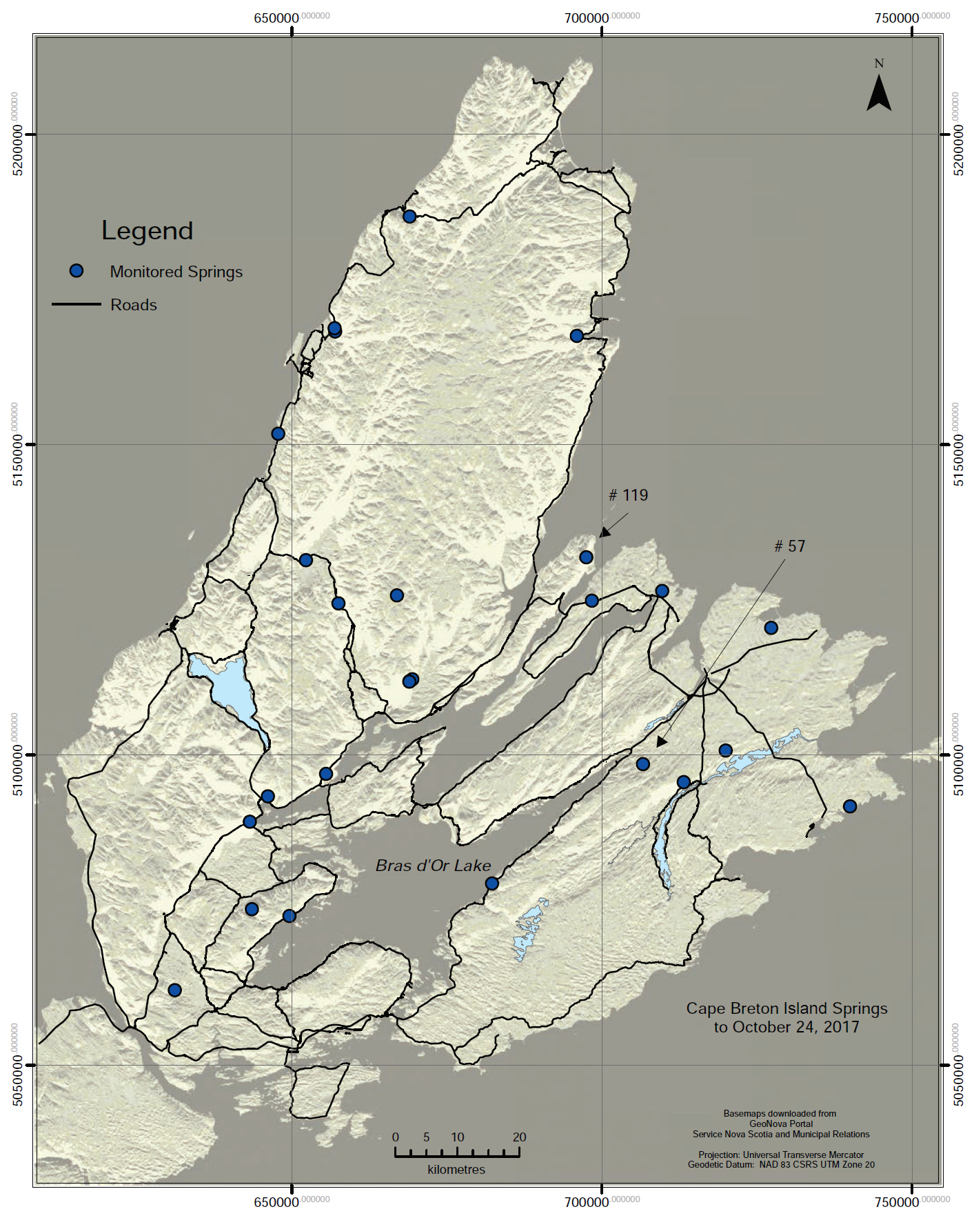
42 The pH of spring waters (Table 10) in all but the Atlantic Coastal hydrological region was primarily neutral to moderately basic. The exceptions varied from alkaline pH with limestones, to acidic pH associated with coal mine pools and strip mines in the Lowland region. In the Atlantic Coastal region, the abundance of wetlands and scarcity of springs is expected to account for the lower pH range. The Lowland region is also associated with a lower pH range, due in part to mine pools and the influence of coal seams.
43 Precipitates and mineral deposits associated with springs have typically been noted with hot springs (Renaut and Jones 2003) and limestone-precipitating springs (Cantonati et al. 2016). No such deposits have been discovered on the Island to date. However, iron precipitates, floc and algae have been noted associated with acid drainage, mine pools and reclaimed strip mine drainage, as well as localized wetlands.
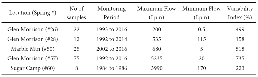
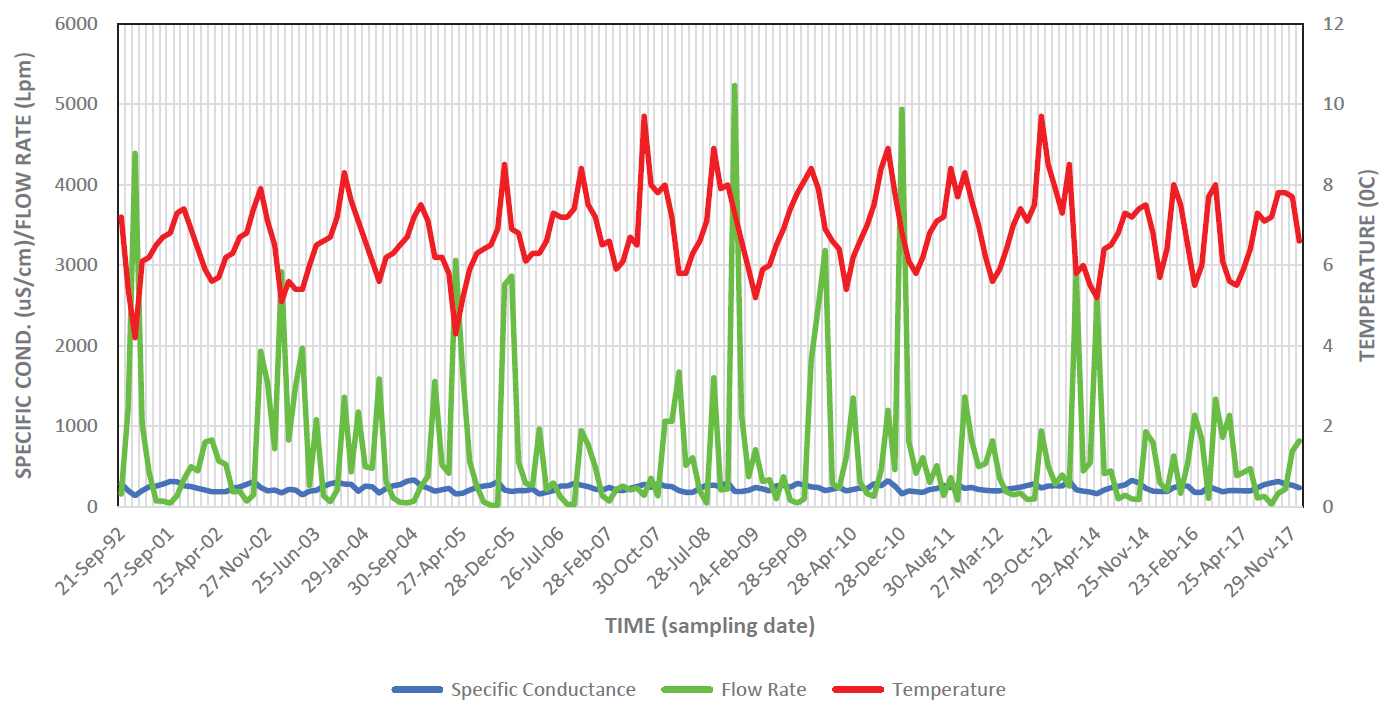
SELECT SPHERES OF INFLUENCE
44 The following section provides a more detailed description of five SOIs.
Hillslope Steep Fault SOI
45 Deep crustal faults on the Island were created during the formation of the Appalachian mountain belt and later Mesozoic rifting. Cenozoic exhumation brought these features near to the surface and into the active groundwater flow field as a hydraulically active Structural HU (Baechler 2015). Since these features are usually found underlying the steep transition slopes (Fig. 7) between the lowland and highland peneplains, the topographic relief also supports spring formation.
 Display large image of Figure 7
46 This SOI encompasses most of the high discharge springs. A total of 105 springs (20.6% of total) were classified under this SOI. Five sites encompassed closely spaced springs; termed spring fields (Fig 7). The largest spring field was located at Rear Baddeck, with 45 springs spread over 2.5 km of strike length. The remaining four sites included Kelly’s Mountain with 6 springs along 0.9 km, Bucklaw with 20 springs along 13 km, Melford with 11 springs over 2.5 km and East Lake Ainslie with 7 springs along 0.6 km. While the Rigwash valley exhibits numerous springs, which are potentially fault controlled, the springs tend to discharge from overlying rockfall/alluvial systems at surface and are discussed within that SOI.
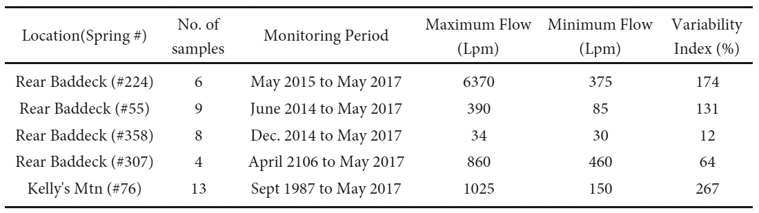
47 Instantaneous discharges within faults were quite variable ranging from Meinzer Category 3 to 8. Faults included the most Category 4 springs (12) of the SOIs, with discharge ranging between 610 and 2250 Lpm. Discharge from the one Category 3 spring, which was an accumulation of flow from four closely spaced springs, was measured at 7140 Lpm. Discharge at five monitored springs with sufficient data (Table 11) showed variable flow (>100%), while one spring showed sub variable flow (64%) and one showed constant flow (12%).
 Display large image of Table 11Note: Variability Index (Meinzer 1923) calculated as: (100) (maximum flow - minimum flow / average flow of all measurements). Variability
Index categories are defined as: constant spring not more than 25%; sub variable spring more than 25% but not more than 100%;
variable spring more than 100%.
Display large image of Table 11Note: Variability Index (Meinzer 1923) calculated as: (100) (maximum flow - minimum flow / average flow of all measurements). Variability
Index categories are defined as: constant spring not more than 25%; sub variable spring more than 25% but not more than 100%;
variable spring more than 100%.
48 Single temperature measurements showed mainly ambient conditions, with ten springs exhibiting seasonal temperature fluctuations and 12 with no data. One site (#307) had a temperature data logger recording between April 2016 and September 2017. The data indicated ambient conditions with temperatures ranging between 6.5° and 7.4°C. Although it is likely that the faults could allow deeper, warmer waters to the surface, no thermal springs have been detected to date.
49 Given the wide range in hydrologic settings there is a notable variability in instantaneous SC values, indicating 57% hyperfresh, 34% fresh, 7% unknown and 2% other. The latter includes one slightly saline spring (2467 uS/cm) and one hypersaline spring (104,400 uS/cm).
50 Thirty springs had at least one water chemical analysis. Nineteen of these springs were hyperfresh, exhibiting a wide range of mixed water types and two core water types: calcium-bicarbonate (n = 8) and sodium-chloride (n = 3). Ten of the springs exhibited fresh water, either calcium-bicarbonate or sodium-chloride type, and three were a mixed water type. The pH values were all neutral to moderately basic, which appears anomalous given the low TDS. The hypersaline spring was a dominant sodium-chloride type with a neutral pH (7.3). None of these springs exhibited any precipitates at their outfalls.
Karst SOI
51 Approximately 23% of Cape Breton Island consists of a wide variety of bedrock (metacarbonates, carbonates and evaporites), which has the potential for karst development. Lowland karst units are generally characterized by broad-scale, till-covered, thick evaporite sequences. Found within this zone are solution trenches near basin boundaries, salt diapirs and extensive foundering zones due to salt dissolution, which led to the development of karst breccias to depths exceeding 300 m (Baechler and Boehner 2014).
52 A total of 28 springs (5.5% of all springs) were identified within three karst related SOI’s (Fig. 8); including karst terrain (16), sinkhole overflow (11) and cave (1). There is an overlap with the salt diapir SOI, which includes an additional three sinkholes and one cave SOI, as discussed later.
53 Single discharge measurements were quite variable, ranging from Meinzer Category 4 to 8, with the highest number of springs positioned in category 4 (33%) followed by categories 5 and 7 (37% combined). The variability is expected to be due, at least in part, to the extent of infilling of preglacial karst features with glacial debris such as till, diamicton and sand/gravel. The Category 4 springs ranged in single discharges from 875 to 2700 Lpm. One of the greatest discharges (1690 Lpm) originated from a series of four linked sinkholes within the Washabuck solution trench at Rear Estemere (Fig. 8). Of the five monitored springs (Table 12) all can be classified as variable flow (>100%), based upon the variability index.
 Display large image of Table 12Note: Variability as defined in Table 11.
54 Single temperature measurements were within the ambient range. Eight springs showed seasonal values, related to heating from exposed sinkhole ponds. One temperature logger at spring #50 at the base of Marble Mountain, located within exposed marble karst terrain, exhibited seasonal conditions with a temperature range of 0 to 18°C.
55 Instantaneous SC values indicated a wide variability, as expected given the range in rock types in which karst is developed. A total of 42% of springs associated with karst were hyperfresh, 27% fresh, 23% slightly saline and 8% moderately saline.
56 Twelve karst related springs had at least one water chemical analysis. Unlike the mixed water types found in the fault related springs, most karst related springs exhibited defined types. Limestones were associated with calcium-bicarbonate water type (n = 7), and gypsum evaporites were associated with calcium-sulfate (n = 2), sodium-sulfate (n = 1) and one sodium-chloride (n = 1) types. The one mixed type was a calcium/sodium-bicarbonate/chloride from a karst cave spring within the tidal zone. The pH values were neutral to moderately basic (6.2 to 8.3). None of the karst related springs exhibited precipitates at the outfall.
Salt Diapir SOI
57 The Cape Breton Island diapiric province is prominent along the west coast of the Island and offshore under the Gulf of St Lawrence. The diapirs were driven by downslope, gravitational compression during subsidence throughout the Carboniferous and therefore are not presently active. They consist of an Upper Windsor Group structural carapace overlying lower unexposed Windsor Group halite, interbedded with large thicknesses of shale, gypsum and carbonates. Three of the eleven salt diapirs present on the Island are near surface and exposed in wave cliffs at Mabou Mines, Port Hood Island and Broad Cove (Fig. 8), as noted by Baechler and Boehner (2014). The adjacent drag zones exhibit lithologies rotated into steeply dipping attitudes, resulting in significant folding, faulting and fracturing (Baechler 2015).
58 A total of six springs have been identified within the Mabou Mines and Broad Cove diapirs. These include one discharging from a karst cave within the central evaporite core, three seeping out of the wave cliff from the up-warped argillaceous, limestone flanks and three discharging as overflow out of three 10 to 80 m diameter, flooded sinkholes. Two of the active sinkholes are positioned in a valley floor directly over the Finlay Point diapir core, with Meinzer 5 discharges. The remainder, including the largest sinkhole, were in the Meinzer 7 to 8 category range. Given the wave cliff exposure and heating of sinkhole ponds the temperatures were predominately seasonal, except for ambient conditions from the karst cave.
59 The five springs where water was available for sampling gave SC values in the slightly saline range (1006 to 1800 uS/ cm). The only exception was the largest sinkhole which was fresh (229 uS/cm), suggesting it is not hydraulically linked with the underlying diapir.
Rockfall/Alluvial SOI
60 Clow et al. (2003) and McClymont et al. (2011) noted that scree slopes can form groundwater reservoirs, providing contribution to streamflow through complicated flow paths. Grant (1994) observed that Cape Breton Island’s landscape has been modified from exposure to proglacial, periglacial and paraglacial conditions, resulting in colluvial deposits that cover about 4% of the island. Rockfall (talus), landslide, avalanche, debris flow, creep and solifuction processes have created localized scree slopes along the steep margins of the Highlands within the Canyon and Mountain Flank hydrological regions. In localized areas these can interfinger with alluvial fans and elevated kame terraces. Combined these processes create the rockfall/alluvial SOI.
61 All scree slopes on the Island are below the present-day tree line and appear to be relict, vegetated landforms, except for the Grande Falaise in the Rigwash Valley (Fig. 9). In the Canyon region these deposits are now being eroded and redistributed down valley by adjacent rivers, which is evident in the Clyburn River canyon (Fig. 9). This process is referred to as the paraglacial cycle of sedimentation (Church and Slaymaker 1989). The discharge response of springs emanating from the base of scree slopes reflects rapid transmittal of water through layers of coarse debris common at the base and slower release from stratigraphically higher interbedded, finer-grained sediment layers (Clow et al. 2003).
62 A total of 20 springs (3.9%) have been documented within the Rockfall/Alluvial SOI (Fig. 9) at New Campbelton along the northeastern flank of Kelly’s Mountain, at Bucklaw along the eastern flank of Lewis Mountain, within the canyons of the Northeast Margaree, Clyburn, Grande Anse and North Aspy rivers, and in the Rigwash Valley along the northwestern flank of the Cape Breton Highlands. Additional springs may be associated with this SOI within the Hillslope steep SOI, however vegetated slopes make the underlying geology unknown. While the apex of the scree slopes is composed primarily of bedrock outcrop, the slopes may comprise a variety of underlying hydrostratigraphic units, including Structural HU, Igneous Plutonic and Volcanic/Metamorphic HUs, as well as a variety of glacial deposits such as Till HU, Sand/Gravel HU and Colluvium HU from multiple talus cones and alluvial fans.
63 Single discharge measurements ranged from Meinzer categories 5 to 8, with most discharges classified as category 7. Two springs are category 4, both in the Rigwash Valley, which is also fault controlled. It is expected that some flow within this system infiltrates into underlying coarse, permeable glacial debris and therefore does not present itself as springs. Of the four monitored springs with sufficient data (Table 13) three exhibited variable discharge indices (223% to 282%) and one exhibited a subvariable index of 57%.
 Display large image of Table 13Note: Variability as defined in Table 11.
64 Single measured temperatures were mostly ambient, with three springs showing seasonal temperatures. Hourly temperature data logger records at the Grande Anse site (#185) monitored between July 2014 and April 2016 exhibited ambient temperatures ranging between 5.7° and 6.8°C. This spring exhibited no diurnal fluctuations, with delayed and at times unresponsive relationship to seasonal conditions, suggesting the influence of a deeper flow system. The Kiosk site (#275), data logger records compiled between September 2015 and October 2016, exhibited a relatively constant temperature range between 6.8° and 7.3°C. In contrast the outflow from the spring fed Melanie Pond (#281) monitored between February and October 2016, exhibited a seasonal temperature range from 0° to 25°C, due to heating in the shallow upgradient pond, which was never ice covered.
65 Specific conductance values were available for 20 springs; of which 12 were hyperfresh and 8 were fresh. Four had water chemical analyses showing a hyperfresh to fresh (TDS 67 to 150 mg/L), soft to moderately soft (hardness as CaCO₃ ranging from 41 to 65 mg/L), corrosive, calcium-bicarbonate to calcium-chloride/bicarbonate type water, with a neutral to moderately basic pH of 7.6 to 8.0. None of the springs exhibited precipitate at their outfalls.
Debris Avalanche SOI
66 One of the regions identified in Canada as susceptible to landslide hazard are the deep gorges and canyons within the Cape Breton Highlands (Evans et al. 2005). Although a variety of landslide morphologies exist, thin-skinned debris flows dominate recent mass wasting processes in the Highlands (Wahl et al. 2007). Such debris flows resulting from springs have been reported from a wide range of mountainous environments (Van Steijn 1996; Otton and Hilleary 1985; French 2007).
67 Finck (1993) and Wahl et al. (2007) investigated 88 thin-skinned, debris avalanche events within canyons and gorges incised into the Cape Breton Highlands. They reported that the avalanche sites were typically long and narrow, commonly initiated just below the intersection of the valley wall and highland peneplain, had no association with large-scale surface depressions and were shallow, removing no more than 1.5 m of the surface. The point of failure was primarily where groundwater discharged as springs between: (1) weathered material and underlying more competent bedrock, (2) low permeable lodgement till overlain by highly permeable colluvium, and/or (3) impermeable weathered bedrock saprolite overlain by permeable colluvium. Fourteen sites exhibited debris discharge into rivers below, which at select sites created debris dams across rivers up to 38 m in width (Finck 1993).
68 Of the initial 88 sites identified with debris avalanches, a total of 32 were located based on the presence of active, non-vegetated scars on recent (2011 to 2016) Google Earth satellite images. An additional 36 sites were identified using the same approach throughout highland areas over Cape Breton Island (Fig. 7). All were associated with deeply incised, “V”-shaped canyons and gorges. The avalanche initiation sites were predominately at the peneplain – steep slope transition, with 75% located at elevations exceeding 300 m. Most sites occurred on steep slopes with 86% exceeding 50% slope and 31% exceeding 75% slope.
SPRING MONITORING
69 The provincial groundwater observation well monitoring program does not include springs at present. Three temporal trends can be used to characterize spring discharge (Manga 1999), including: (1) long term trends, (2) time lag between recharge and peak discharge, and (3) mean residence time. The Cape Breton Island dataset only allows for discussion of long-term trends.
70 A spring monitoring program was established and is now being operated by the authors from the above dataset starting in 2016. Of the 510 springs identified to date 27 were selected (Fig. 10) for monitoring, with details summarized in Table 14.
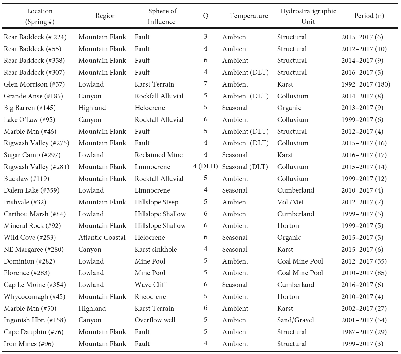 Display large image of Table 14Notes: Region - Hydrological region; Q - Meinzer discharge Category; Period - time interval for sampling; n - number of samples;
DLH - data logger of head levels available for select periods; DLT - data logger temperature data available for select periods.
Display large image of Table 14Notes: Region - Hydrological region; Q - Meinzer discharge Category; Period - time interval for sampling; n - number of samples;
DLH - data logger of head levels available for select periods; DLT - data logger temperature data available for select periods.
71 The selection of monitoring sites was based upon springs with relatively natural catchments, which provided areal coverage of the Island, through all hydrological regions. Where possible sites were selected with long-term records. The minimum frequency for sampling is established at twice per year to characterize the maximum (spring/fall recharge) and minimum (late summer recession) envelope which can be used to detect long-term trends related to changing climate.
72 Specific conductance, temperature, and flow rate for one of the long-term stations is provided in Figure 11. Spring #57 has been monitored at a monthly frequency for 25 years and represents a karst spring in the Lowland region. Temperatures exhibit seasonal fluctuations with an ambient range of 5° to 10°C. Specific conductance remains stable ranging from 139 to 335 uS/cm. Flow rates vary seasonally, ranging from 20 to 5230 Lpm.
 Display large image of Figure 11
73 A Mann-Kendall trend test was carried out on the field parameters from Spring #57 using USEPA’s ProUCL 5.1. Software and documentation were downloaded November 24, 2018 from https://www.epa.gov/land-research/proucl-software. The results indicated that there was insufficient evidence to identify a significant trend at the specified level of significance (alpha = 0.05) for the parameters shown.
MANAGEMENT ISSUES
74 Numerous authors have noted the need for research and monitoring of springs as part of an overall groundwater/ surface water management program (Rivard et al. 2014; Nichols et al. 2014; Finck 1993; Hinton 2014). To support effective provincial water resources management and permitting, interdisciplinary spring research should focus on:
- Identification and characterization of additional springs: This should include both terrestrial, as well as submarine springs in the nearshore coastal environment. Investigations of groundwater dependent ecosystems associated with springs should also be a focus. Priority should be given to springs associated with areas of enhanced land use, exist-ing large groundwater withdrawals and important aquatic ecosystems.
- Changing Climate: Select springs should be instrumented to allow for enhanced monitoring frequency of discharge, temperature, and select chemical parameters to better evaluate long term change and to provide an early warning system for impacts associated with changing climate.
- Integrated Monitoring: The provincial groundwater observation well monitoring program should be integrated and enhanced with springs within select hydrological regions and SOIs.
CONCLUSIONS
75 Cape Breton Island provides a hydrogeological view into a tectonically ancient, exhumed, glaciated, deglaciated, now tectonically inactive, deep crustal terrain. Identification of 510 springs has indicated 19 spheres of influence, spread out over seven hydrological regions.
76 There is a wide variability in discharge from Meinzer category 8 to 3; no large magnitude category 1 or 2 springs have been identified to date. The larger flows were related to faults and karst, followed by rockfall/alluvial systems, primarily in the Mountain Flank Region. Total dissolved solids were highly variable in both concentration (ranging from 38 to 73,000 mg/L) and spatial distribution. The springs exhibited predominately hyperfresh to fresh water; with the Lowland and Mountain Flank regions exhibiting the more saline springs. The pH ranged primarily from neutral to moderately basic, with alkaline conditions associated with lime-stones, and acid conditions associated with coal mine pools, reclaimed coal strip mines and wetlands. Temperatures were predominantly ambient to seasonal, with no warm or hot springs encountered.
77 Fault-controlled springs comprised approximately 20% of the data set. Five sites encompassed numerous, closely-spaced springs, termed spring fields. They comprised most of the Category 4 springs and the only Category 3 spring; flow regimes were predominantly variable.
78 Karst-controlled springs comprised approximately 6% of the data set. Spot discharges were variable, ranging from Meinzer categories 4 to 8, and exhibited predominately variable flow regimes. The variability is expected to be due, at least in part, to the extent of infilling of pre-glacial karst features with glacial debris.
79 Three of the eleven salt diapirs present on the Island are near surface and exposed in wave cliffs, where six springs were identified; either discharging out of the cliffs, or as overflows from flooded sinkholes. These springs exhibited predominantly seasonal temperatures with generally slightly saline chemistry.
80 Rockfall/Alluvial controlled springs comprised approximately 4% of the data set. Spot discharges ranged from Meinzer categories 5 to 8, with a predominantly variable flow regime. It is expected that some flow within this system infiltrates into underlying permeable deposits and therefore does not present itself as springs.
81 A total of 68 sites documented springs creating thin-skinned debris flows. All were associated with deeply incised, “V”-shaped canyons and gorges.
82 Twenty-seven springs were selected for an ongoing monitoring program. The springs with longer term data do not suggest changes in response to changing climate.
83 All data has been provided to the Nova Scotia Department of Energy and Mines for inclusion in their water resources database; to be made public at their discretion.
84 Future research is required to: (1) identify and characterize these springs in select high priority areas, (2) identify the groundwater dependent ecosystems associated with the springs, and (3) instrument selected springs to aid in identifying impacts associated with changing climate.
The paper was significantly improved by comments received through numerous discussions with and responding to constructive criticism from anonymous reviewers and the editor. The authors would like to gratefully acknowledge and thank all those that assisted in this endeavor. Mr. Bill Jones is greatly acknowledged for developing the associated GIS database, which facilitated the analysis.