Articles
Stratigraphy and depositional setting of the Silurian–Devonian Rockville Notch Group, Meguma terrane, Nova Scotia, Canada
ABSTRACT
The Silurian–Devonian Rockville Notch Group occurs in five separate areas along the northwestern margin of the Meguma terrane of southern Nova Scotia. In each area, the lowermost unit of the group is the White Rock Formation, which unconformably overlies the Lower Ordovician Halifax Group. Early Silurian U–Pb (zircon) dates from metavolcanic rocks in the White Rock Formation indicate that the unconformity represents a depositional gap of about 25 Ma. The U–Pb ages are consistent with early Silurian (Llandovery) trace fossils and sparse shelly faunas in metasedimentary rocks interlayered with the metavolcanic rocks. The metasedimentary rocks locally contain phosphatic ironstone and Mn-rich beds, and are overlain by mainly metasiltstone with abundant quartzite and metaconglomerate lenses. Some of the latter were previously interpreted to be Ordovician tillite. The White Rock Formation is conformably overlain by the slate- and metasiltstone-dominated Kentville Formation, which contains Upper Wenlock to Pridoli graptolites and microfossils. The overlying Torbrook Formation consists of metalimestone, metasandstone and metasiltstone, interbedded with phosphatic ironstone and minor mafic metatuff, and contains Pridoli to early Emsian fossils. It is in part laterally equivalent to the New Canaan Formation in the Wolfville area, which is dominated by slate, pillowed mafic metavolcanic rocks and fossiliferous metalimestone. Volcanic rocks in the Rockville Notch Group are alkalic and formed in a within-plate setting, probably related to extension as the Meguma terrane rifted from Gondwana. This process may have occurred in two stages, Early Silurian and Early Devonian, separated by a hiatus in volcanic activity. Stratigraphic differences suggest that the Meguma terrane was not adjacent to Avalonia before emplacement of the South Mountain Batholith.
RÉSUMÉ
Le groupe silurien–dévonien de Rockville Notch est présent dans cinq secteurs distincts le long de la limite nord-ouest du terrane de Meguma dans le sud de la Nouvelle-Écosse. Dans chaque secteur, l’unité basale du groupe est la formation de White Rock, qui recouvre en discordance le groupe de l’Ordovicien inférieur d’Halifax. Des datations U–Pb sur zircon de roches métavolcaniques de la formation de White Rock situant l’unité au Silurien précoce révèlent que la discordance représente une lacune sédimentaire d’environ 25 Ma. Les âges U–Pb obtenus correspondent aux ichnofossiles et à la faune coquillère clairsemée du Silurien précoce (Llandovérien) présents à l’intérieur des roches métasédimentaires interstratifiées avec des roches métavolcaniques. Les roches métasédimentaires renferment par endroits du grès ferrugineux phosphaté et des strates riches en Mn, et elles sont principalement recouvertes de métasiltstone accompagné d’une abondance de quartzite et de lentilles de métaconglomérat. Certaines de ces dernières roches avaient précédemment été interprétées comme de la tillite de l’Ordovicien. La formation de White Rock est recouverte de façon concordante par la formation à prédominance d’ardoise et de métasiltstone de Kentville, qui abrite des graptolites et des microfossiles du Wenlock supérieur au Pridolien. La formation sus-jacente de Torbrook est constituée de calcaire métamorphique, de métagrès et de métasiltstone interlités de grès ferrugineux phosphaté et d’une quantité modeste de tuf mafique, et elle renferme des fossiles du Pridolien à l’Emsien précoce. Elle est en partie latéralement équivalente à la formation de New Canaan dans le secteur de Wolfville où prédominent de l’ardoise, des roches métavolcaniques mafiques en coussins et du calcaire métamorphique fossilifère. Les roches volcaniques du groupe de Rockville Notch sont des roches alcalines qui se sont formées dans un environnement intraplaque, probablement apparenté au prolongement créé lorsque le terrane de Meguma s’est détaché du continent de Gondwana. Le processus pourrait s’être produit en deux phases, au cours du Silurien précoce et du Dévonien précoce, séparées par un hiatus de l’activité volcanique. Les différences stratigraphiques laissent supposer que le terrane de Meguma n’était pas adjacent à l’Avalonie avant la mise en place du batholite de South Mountain.
[Traduit par la redaction]
INTRODUCTION
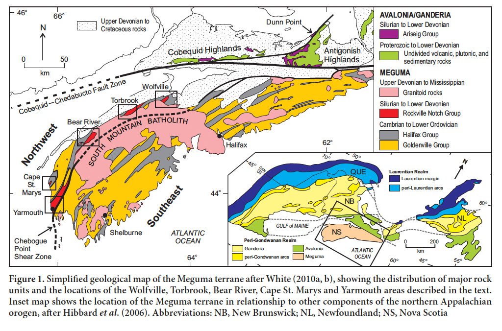
1 Metavolcanic and metasedimentary rocks of the Rockville Notch Group occur in five separate areas along the northwestern margin of the Meguma terrane of southwestern Nova Scotia (Fig. 1). These areas are located on the northwestern side of the Chebogue Point shear zone, which has been suggested to be a major boundary in the Meguma terrane (White 2010a; Waldron et al. 2009; White et al. 2012). Although stratigraphic details in the Rockville Notch Group differ in the five areas, prominent quartzite beds are present in all and considered to be a characteristic component of the lowermost unit in the succession, the White Rock Formation (Faribault 1909, 1921; Crosby 1962; Smitheringale 1960). The overlying Kentville, Torbrook and New Canaan formations have been recognized only in the Bear River, Torbrook and Wolfville areas (White 2010a, b; White et al. 2017a, b).
 Display large image of Figure 1
2 Schenk (1995b) referred to these formations as groups, and assigned them to the “Annapolis Supergroup”. However, the name “Annapolis” was used earlier, on the 1965 Geological Map of Nova Scotia, as the group name for the Triassic Wolfville and Blomidon formations. Moreover, detailed mapping in the Southwest Nova Project (White 2010a, b, 2013) did not enable subdivision of the Silurian and Devonian formations into mappable units, and hence they are still more correctly termed formations, not groups. White (2010b) introduced the collective name Rockville Notch Group for these formations, based on a well-exposed and historically well-described section with good fossil and U–Pb (zircon) age control in the Rockville Notch area in the Fales River valley near Torbrook.
3 The purpose of this paper is to document the stratigraphy of the Rockville Notch Group based on mapping during 1998–2009 as part of the Southwest Nova Project of the Nova Scotia Department of Natural Resources (White 2010a, b, 2013; White et al. 2017b) and more recent work, including U–Pb zircon dating (White et al. 2017a). We first describe the historical context and age constraints, and then present our interpretation based on those historical constraints, combined with new data. We also present previously unpublished chemical data from volcanic units in the Cape St. Marys, Torbrook and Wolfville areas, and compare them to previously published data from the Yarmouth area (MacDonald et al. 2002). We use these data to interpret the depositional setting of the Rockville Notch Group and its implications for the history of the Meguma terrane.
HISTORICAL BACKGROUND
White Rock Formation
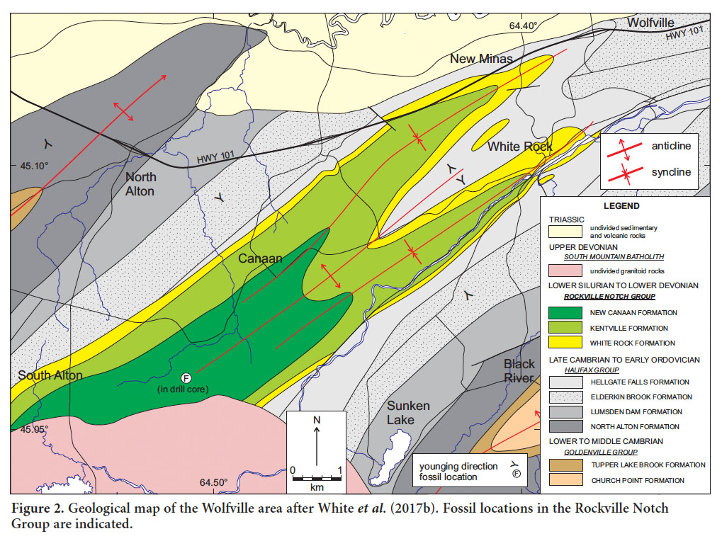
4 Originally the White Rock Formation was defined in the Wolfville area (Figs. 1, 2) mainly on the basis of an upper and lower quartzite bed separated by slate (Faribault 1909, 1921; Crosby 1962). The formation was extended to the southwest into the Torbrook, Bear River, Cape St. Marys, and Yarmouth areas based primarily on the occurrence of one or more such quartzite beds (Faribault 1909, 1921; Smitheringale 1960, 1973; Taylor 1965, 1969). The forma tion in the Torbrook, Cape St. Marys and Yarmouth areas also includes volcanic units absent in the Wolfville and Bear River areas, as noted by Smitheringale (1960) in his redefinition of the formation.
 Display large image of Figure 2
5 The relationship of the White Rock Formation to the underlying Halifax Group has been variously interpreted. Smitheringale (1960, 1973) thought that slate units in the White Rock Formation were indistinguishable from those in the Halifax Group and concluded that there was no hiatus in sediment accumulation between the two units, although he noted that erosion could have occurred locally. Depending on the map area, he placed the base of the White Rock Formation at the bottom of the lowest quartzite unit or of the volcanic package. Schenk (1972) proposed a conformable contact and identified a diamictite (interpreted as a til-lite) in the lowermost part of the White Rock Formation in the Wolfville and Cape St. Marys areas. Subsequently, Schenk and Lane (1981) placed the diamictite in the uppermost part of the Halifax Group and considered it to be of Late Ordovician age. Long (1991, 1992, 1994) again assigned the diamictite units to the White Rock Formation but reinterpreted them as non-glacial in origin, citing evidence such as absence of dropstones and lack of lateral continuity. He also showed that the diamictite does not occur in a consistent stratigraphic position; instead he considered these clast-supported conglomerate beds to be gravity-flow deposits formed in a non-glacial slope setting. Long (1991, 1992) suggested that they are of Early to Middle Ordovician age based on inferred stratigraphic continuity with the Halifax Group. Keppie (2000) showed the White Rock Formation to extend down into the Middle Ordovician and to be locally conformable or disconformable on the Halifax Group. In the Torbrook area the provincial geological map (Keppie 2000) showed the White Rock Formation overlying the Goldenville Group, although we have confirmed that in fact it overlies the Halifax Group, as elsewhere (Fig. 1).
6 Culshaw and Leisa (1997) interpreted the White Rock Formation in the Cape St. Marys area to lie in a synclinorium with extensive shear zones in the Halifax Group on both limbs, and the whole area was referred to as Cape St. Marys shear zone. Later, Culshaw and Dickson (2015) showed that the White Rock Formation forms a simple syncline and re-stricted the Cape St. Marys shear zone to its western limb and, based on structural evidence, showed that the original contact was an angular unconformity now embedded in the ductile shear zone.
7 In the Yarmouth area, the White Rock Formation has also been inferred to occupy a synclinal structure with mainly sedimentary components, including prominent quartzite units, toward the bottom and mafic and felsic volcanic components toward the top (Taylor 1965, 1967; Sarkar 1978; Lane 1979). The relationship with the underlying Halifax Group was variously inferred to be conformable or uncertain, but Culshaw and Leisa (1997) documented shear zones on both the western and eastern margins, which they termed the Cranberry Point and Chebogue Point shear zones, respectively. Cooling ages of muscovite in the Cranberry Point shear zone, as well as in the Cape St. Marys shear zone to the north, indicated a middle Carboniferous (Alleghanian–Variscan) age for the deformation (Culshaw and Reynolds 1997).
8 Fossils are sparse in the White Rock Formation. Lane (1975) reported the occurrence of shelly fossils in the Yarmouth area, and cited A. Boucot (personal communication, 1971) for identifying a castellated rhynchonellid brachiopod that has a maximum age of Caradocian but is probably much younger. Ferguson (in Williams et al. 1985) incorrectly located this fossil occurrence in the Cape St. Marys area. Lane (1979) reported shelly fossil hash in a quartzite outcrop in the Wolfville area, but this observation was not confirmed during the present study. In the Torbrook area, Ludlow graptolite specimens, identified as Monograptus sp. cf. M. tumescens (Smitheringale 1960), were collected from slate above the upper quartzite in the White Rock Formation and assigned to the Kentville Formation. Smitheringale (1973) later assigned these slates to the upper part of the White Rock Formation. Subsequent work (e.g., Bouyx et al. 1997) reassigned these graptolite-bearing slates to the Kentville Formation.
Kentville Formation
9 The Kentville Formation was defined in the Wolfville area (Fig. 2) as a unit of interbedded marine slate and siltstone that conformably overlies the White Rock Formation and conformably underlies the New Canaan Formation (Ami 1900; Crosby 1962). The Kentville Formation was also mapped in the Torbrook area (Smitheringale 1960, 1973; Taylor 1965, 1969) but not in the areas to the southwest (Smitheringale 1960, 1973; Taylor 1965).
10 Graptolites and other fossils were reported in the Kentville Formation from the Fales River section, the area east of Spinney Brook, and Torbrook River (Fig. 3) by Smitheringale (1960) and dated as Ludlow. Bouyx et al. (1997) also described graptolites and other fossils collected from the lower part of the Kentville Formation in Fales River and assigned a Late Wenlock to Early Ludlow age (i.e., around the Middle–Late Silurian boundary). Samples collected from the top of the Kentville Formation in Spinney Brook yielded Pridoli (Late Silurian) microfossils (Bouyx et al. 1997). Late Silurian vertebrate and crinoid remains in the upper part of the White Rock Formation in the Bear River area indicate that the upper part of the formation in that area is age-equivalent to the upper Silurian Kentville Formation in the Torbrook area (Blaise et al. 1991; Bouyx et al. 1997).
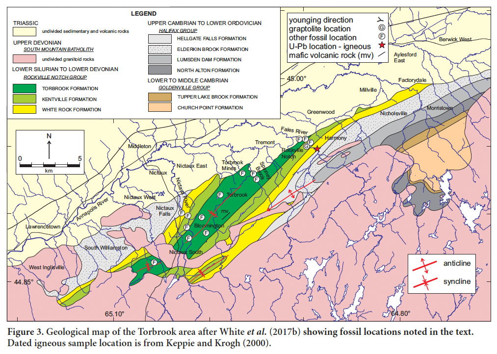 Display large image of Figure 3
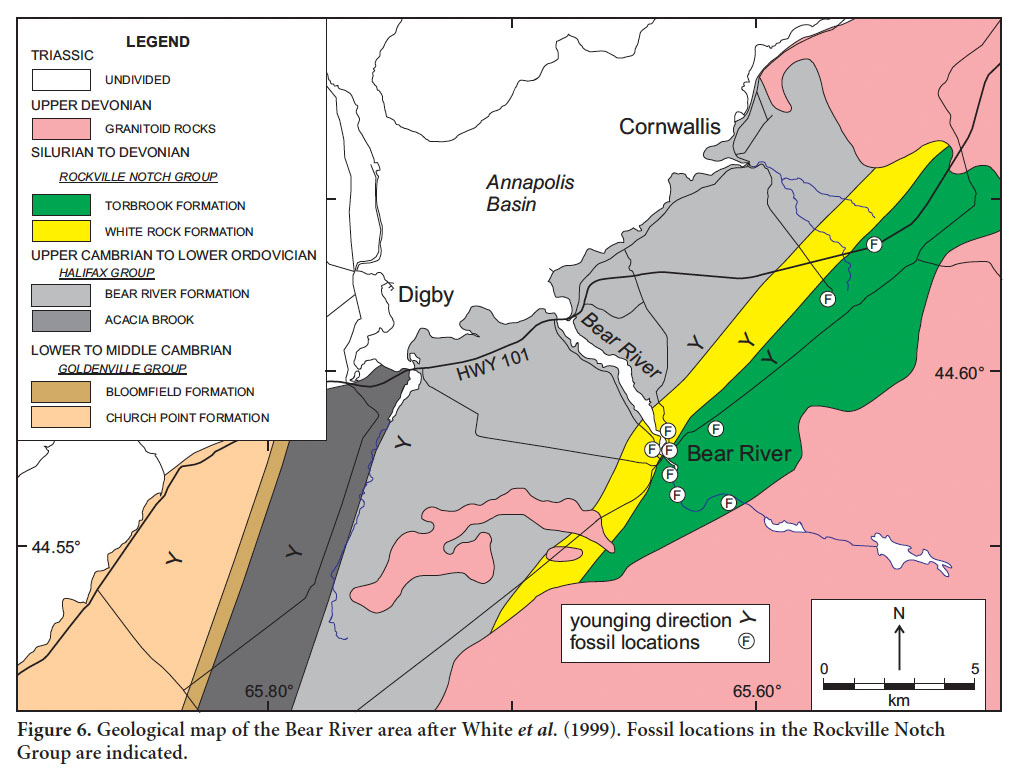
Torbrook Formation
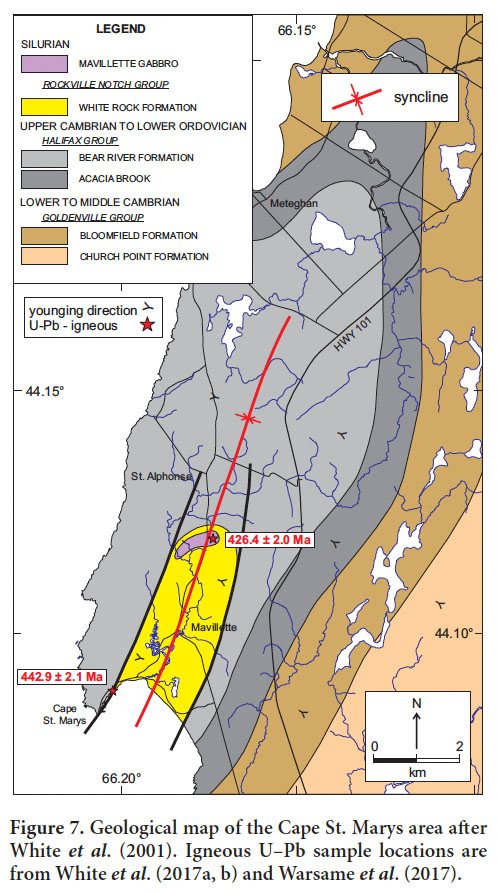
11 Strata overlying the Kentville Formation in the Tor-brook area and the White Rock Formation in the Bear River area were named the Torbrook Formation by Hick-ox (1958). They consist of interbedded marine mudstone, siltstone and sandstone with minor fossiliferous limestone and ‘iron-formation’ (Smitheringale 1960). Volcanic rocks occur in the formation in Spinney Brook (Jensen 1975). Where the Kentville Formation in the Bear River area was not recognized, the contact between the White Rock and overlying Torbrook formations was placed above a massive quartzite, based on the presence of fossils interpreted to be Early Devonian (Lane 1979), but shown later to be late Silurian (Bouyx et al. 1997). In the Torbrook/Spinney Brook area (Fig. 3) the contact between the Torbrook Formation and the underlying Kentville Formation was defined as the first appearance of thinly bedded sandstone (Jensen 1975). The age of the Torbrook Formation is well constrained by fossils. It contains abundant fauna that Boucot (1960), Cumming (in Smitheringale 1973) and Jensen (1975) considered to be Gedinnian to Siegenien, and maybe as young as Early Emsian (Early Devonian). In the sandy basal part of the Torbrook Formation on Spinney Brook, Bouyx et al. (1997) collected samples bearing Urnochitina urna, a chitinozoan of Pridoli age. This fossil indicates that the Torbrook Formation extends down to the Upper Silurian and overlaps in age with the New Canaan Formation, consistent with the field observations during this mapping project (e.g., White et al. 2017b). In the Bear River area, the fossil assemblage includes brachiopods, crinoids and bivalves, and indicates an Early Devonian age (Smitheringale 1973; Blaise et al. 1991; Bouyx et al. 1997). The youngest detrital zircon grain from a sandstone sample from near the top of the Torbrook Formation in the Torbrook area yielded a U–Pb age of 388 ± 8 Ma (Murphy et al. 2004). If reliable, this age suggests a maximum depositional age of latest Early Devonian, perhaps as little as 10 million years prior to intrusion by the South Mountain Batholith and permitting only a narrow window for deformation and metamorphism associated with the Neoacadian orogeny.
New Canaan Formation
12 Crosby (1962) assigned the metasedimentary and mafic metavolcanic rocks that conformably overlie the Kentville Formation in the Wolfville area to the New Canaan Formation. The New Canaan Formation contains crinoids, brachiopods (e.g., Conchidium) and corals that indicate a possible Middle Silurian age (Wilson in Crosby 1962). Boucot et al. (1974) placed the formation in the latest Silurian (Pridoli).
13 Schenk (1995b) correlated the upper part of the volcanic sequence in the Yarmouth area with the New Canaan Formation of the Wolfville area. However, this interpretation is not supported by U–Pb ages from the felsic volcanic rocks (Keppie and Krogh 2000; MacDonald et al. 2002; White et al. 2017a), which show that the volcanic rocks in the Yarmouth area are early Silurian, whereas the New Canaan Formation is of late Silurian to Early Devonian age based on fossils.
REVISED GEOLOGICAL MAPS AND STRATIGRAPHIC INTERPRETATIONS
Introduction
14 Rocks in the Rockville Notch Group were regionally metamorphosed to lower greenschist facies (locally to lower amphibolite facies in the Yarmouth area) and deformed into northeast-trending folds with associated axial planar cleavage during the Middle Devonian Neoacadian orogeny (van Staal 2007; White et al. 2001, 2007, 2017b). In addition, the group was intruded by the ca. 373 Ma South Mountain Batholith and related granitoid rocks (e.g., Clarke et al. 1997, 2004), which resulted in a well-developed contact metamorphic aureole containing mineral assemblages characteristic of up to hornblende-hornfels facies (e.g., Campbell 1999). Although protoliths are typically easily recognized, appropriate metamorphic names are used here to describe these rocks.
Wolfville area
15 In the Wolfville area, the Rockville Notch Group consists of the White Rock, Kentville, and New Canaan formations and occurs on the limbs of the Canaan synclinorium, which comprises the New Minas and White Rock synclines (Fig. 2). The White Rock Formation in the Wolfville area overlies either the Hellgate Falls Formation or the Elderkin Brook Formation of the Halifax Group (Fig. 2), and varies in thickness from about 100 to 200 m. In the White Rock syncline, the White Rock Formation is composed of a series of quartzite beds 1.5 to 10 m thick (Fig. 4a), separated by thin (10 cm to 5 m thick) beds of black slate. These slate beds are like those in the underlying Halifax Group (Crosby 1962; Smitheringale 1960, 1973), although in most outcrops they contain phosphate nodules which were not observed in the Halifax Group slate (White 2010c; White and Barr 2010).
 Display large image of Figure 4
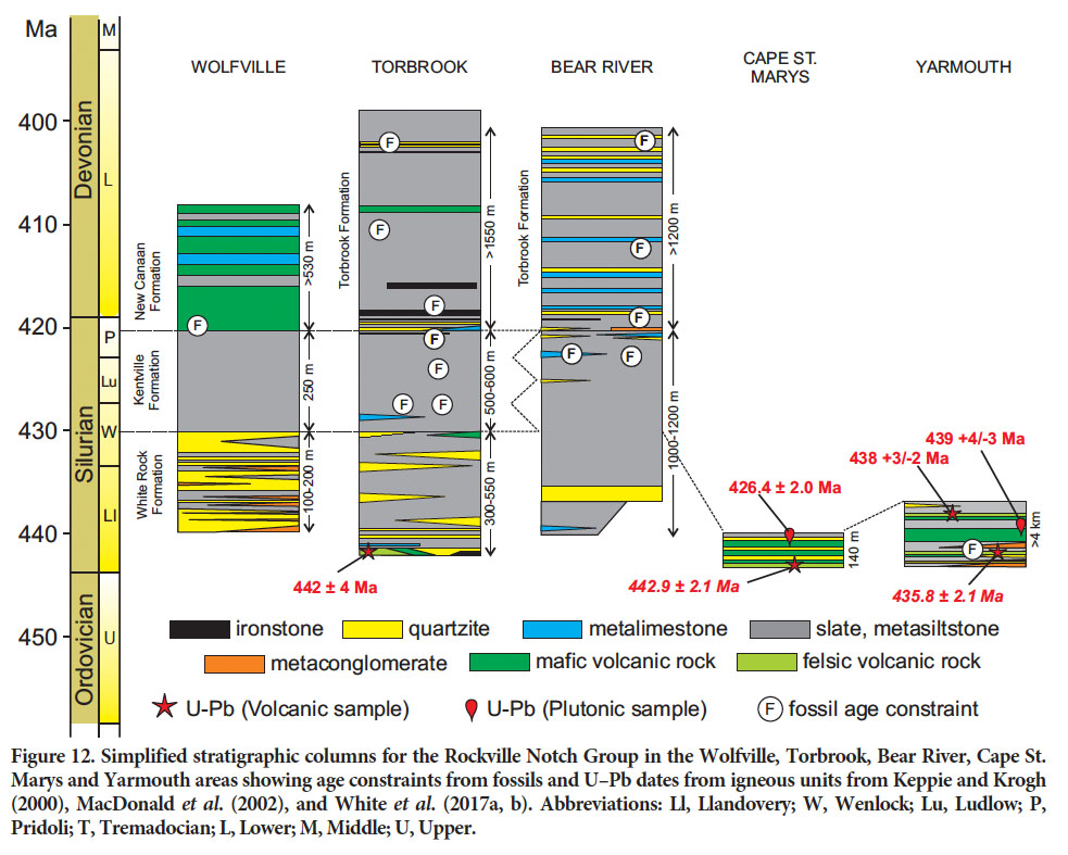
16 Along strike the quartzite and slate beds vary in thickness with an overall lensoid distribution. It is unclear whether this ‘pinch and swell’ character is the result of the original sedimentary environment or of later deformation. Above the quartzite package is a unit of grey to light-green cleaved metasiltstone to slate, locally interlayered with thin (5 to 15 cm thick) beds of pale sulphide-rich metadolostone. Above the slate package is another series of quartzite beds (1 to 5 m thick) interlayered with green-grey metasiltstone and metasandstone. The contact with the overlying Kentville Formation is gradational, with the quartzite beds thinning and then disappearing over 50 m.
17 In the New Minas syncline, the stratigraphy in the White Rock Formation is slightly different. The base of the formation is marked by a series of up to six quartzite beds with thicknesses of 2 to 10 m, interlayered with dark grey to red-brown metaconglomerate to breccia (Fig. 4b), black metasiltstone and slate. In some localities quartzite overlies the Halifax Group, whereas in others metaconglomerate overlies the Halifax Group. The metaconglomerate is the diamictite/tillite of Schenk and Lane (1981), which they included in the upper part of the Halifax Group rather than in the White Rock Formation. The quartzite continues above this unit to the base of the Kentville Formation but is interlayered with grey cleaved metasiltstone to slate and lacks meta-conglomerate. In this area, it is difficult to map a middle ‘slate’ unit or the double quartzite member as defined by Crosby (1962) and Smitheringale (1960, 1973). As in the White Rock syncline, the quartzite varies in thickness along strike with many of the beds displaying a lenticular morphology, tens to hundreds of metres across.
18 Like the White Rock Formation, the overlying Kentville Formation occurs on the limbs of the New Minas syncline and White Rock syncline (Fig. 2). The formation consists of pale grey-green, laminated metasiltstone and slate overlain by black slate (Fig. 4c). The lower slate unit locally contains pyritiferous limestone nodules. The upper contact is marked by a basal metabasaltic flow in the overlying New Canaan Formation, well exposed in Elderkin Brook. The metabasalt is dark green-grey and amygdaloidal, and grades laterally into mafic lithic metatuff and metavolcanic breccia. In contrast, Clark (1977) placed the base of the New Canaan Formation below a mainly calcareous metasiltstone and slate unit. However, these rocks are included here in the Kentville Formation. Overlying the metavolcanic rocks is a succession of dark grey to black siliceous metasiltstone, metasandstone, and metalimestone, all of which are locally interlayered with amygdaloidal metabasalt. The metalimestone and metasandstone locally contain fossils that indicate a latest Silurian (Pridoli) age (Boucot et al. 1974).
19 Clark (1977) subdivided the formation into four metasedimentary and metavolcanic units. James (1998) remapped the area and logged core drilled by Smith (1992). He subdivided the formation into seven informal units; three mainly metavolcanic, three metasedimentary, and one mixed metavolcanic/metasedimentary, the details of which are too small to be indicated on Figure 2. James (1998) noted that towards the top of the formation, the metasiltstone contains abundant sulphide minerals and supported the interpretation of Smith (1992) that this mineralization is similar to sediment-hosted exhalative (SEDEX) deposits.
20 Crosby (1962) estimated that the thickness of the New Canaan Formation exceeds 300 m. Clark (1977) subsequently estimated that it is 725 m, although he included a slate unit in the lower part of the formation. James (1998) included the slate unit in the underlying Kentville Formation and placed a minimum thickness of the New Canaan Formation at 530 m, an interpretation consistent with our observations.
Torbrook area
21 In the Torbrook area the Rockville Notch Group occurs on both limbs of the Torbrook syncline, overlying the Elderkin Brook and Hellgate Falls formations of the Halifax Group (Fig. 3). Along the southeastern limb of the syncline, the base of the White Rock Formation is marked in places by a rhyolitic metatuff or flow that is overlain by amygdaloidal and pillowed metabasaltic flows. Locally the basalt displays peperitic texture with metalimestone as the interstitial material (Fig. 5a). The rhyolite at the base of the formation in Fales River yielded a U–Pb zircon crystallization age of 442 ± 4 Ma (Keppie and Krogh 2000); within error it spans the Ordovician-Silurian boundary, currently placed at 443.4 ±1.5 Ma (Cohen et al. 2013 updated 2017). Along strike the metavolcanic rocks are missing and the basal unit is a quartzite and metasiltstone package up to 5 m thick. However, in the Factorydale area (Fig. 3) the basal quartzite/metasiltstone is interlayered with minor (<1 m thick) felsic crystal metatuff (Cullen et al. 1996). On Fales River, a well-bedded, heavily bioturbated, quartz arenite (~50 m thick; Fig. 5b) with numerous grazing and burrowing trace fossils is stratigraphically above the basalt. This unit was not observed elsewhere.
 Display large image of Figure 5
22 Along the northwestern limb of the syncline the base of the White Rock Formation is well exposed along the west bank of Nictaux River (Fig. 3) and marked by a 5-m-thick section of black Mn- and P-rich metasiltstone interlayered with thin (5 to 40 cm thick) phosphatic ironstone beds. To the southwest these Mn-rich metasiltstone and ironstone beds were once mined (the Parker and Armstrong ore beds of Fletcher 1905a, b). These rocks are overlain by a 3-mthick quartzite bed. Because the base of the White Rock Formation was previously defined at the first quartzite, these Mn-, P-, and Fe-rich beds under the quartzite were included in the upper part of the Halifax Group by MacDonald and Ham (1994) or of the Goldenville Group by Keppie (2000). However, along strike to the northeast, this basal section is dominated by thick amygdaloidal metabasalt flows containing a 2-m-wide quartzite bed, indicating that these rocks are part of the White Rock Formation. The quartzite is capped by a thin (<0.5 m thick) Mn-rich ironstone that was previously mined (in the Foster Pit of Fletcher 1905a, b). A thin-section from the black Mn-rich meta-siltstone on Nictaux River contains a jaw/toothwhorl with two cusps, of questionable acanthodian affinity; if correctly identified, this fossil suggests an age no older than Wenlock (S. Turner, written communication, 2016), inconsistent with the apparent position of these rocks at the base of the White Rock Formation; additional work is thus required to clarify stratigraphic relations in this area.
23 The upper part of the White Rock Formation varies. In Fales River it appears to have the ‘double quartzite member’, with two quartzite beds separated by black featureless metasiltstone. The black slate is like that in the overlying Kentville Formation in the area. In Nictaux River a green mafic lithic metatuff is at the top of the formation. This unit was observed only at low-water conditions. Smitheringale (1973) described a basaltic flow in a similar stratigraphic position in the Nicholsville area, but based on its texture, the unit is more likely to be one of the numerous gabbroic sills that occur in the area. Like the White Rock Formation in the Wolfville area, many of the quartzite and metavolcanic beds are lenticular along strike, as was noted by Smitheringale (1973). The White Rock Formation in the Torbrook syncline area varies in thickness from 300 m to 550 m.
24 The Kentville Formation in the Torbrook area ranges in thickness from 500–600 m and consists of dark grey to black or pale green-grey, featureless to laminated metasiltstone and slate interlayered with thin laminae to thinly bedded pale metasandstone and metasiltstone. In the Fales River and Nictaux River sections, close to the bottom of the unit, black metalimestone nodules are locally common (Fig. 5c). The contact with the overlying Torbrook Formation is gradational. In Spinney Brook the green slate in the upper part of the Kentville Formation becomes increasing interlayered with thicker, coarser-grained meta-sandstone. This change marks the base of the Torbrook Formation. In Nictaux River the upper contact is marked by the presence of a black fossiliferous metalimestone that forms the lowermost unit in the Torbrook Formation. Graptolites and other fauna of Ludlow age were reported in the Kentville Formation in the Fales River section (Smitheringale 1973) and the area east of Spinney Brook (Jensen 1975). Bouyx et al. (1997) also described graptolites and other fossils collected from the base of the Kentville Formation in Fales River and assigned an age of Late Wenlock to Early Ludlow (Middle– Late Silurian transition). Samples collected from the top of the Kentville Formation in Spinney Brook yielded Pridoli (Late Silurian) microfossils (Bouyx et al. 1997).
25 The Torbrook Formation occurs in the core of the Tor-brook syncline and is about 1500 m thick. The Spinney Brook section was described in detail by Hickox (1958), Smitheringale (1973), and Jensen (1975). The basal part of the section in Spinney Brook consists of a coarsening-upward metasandstone package interlayered with metasiltstone. Rare macrofossils occur in the finer grained metasandstone. In the Nictaux River the base of the Torbrook Formation is marked by a fossiliferous limestone and black metasiltstone. The remainder of the formation consists of interbedded metasandstone, metasiltstone, slate and metalimestone that are typically heavily bioturbated and fossil-rich. Phosphate nodules are common. A charac-teristic feature of the Torbrook Formation is the presence of quartz-rich and oolitic chamositeand francolite-bearing ironstone beds (Marshall 2011) that are locally fossiliferous and phosphate-rich (e.g., Fletcher 1905b). Mafic lithic metatuff is present near the middle of the formation (mv on Fig. 3), as Jensen (1975) also noted at a similar stratigraphic level in Spinney Brook. The formation contains abundant fauna that Boucot (1960) and Cumming (in Smitheringale 1973) considered to be Gedinnian to Siegenien age, and perhaps as young as Lower Emsian (Early Devonian). In the sandy basal part of the Torbrook Formation on Spinney Brook, Bouyx et al. (1997) collected samples bearing Urnochitina urna, a chitinozoan of Pridoli age. This fossil indicates that the Torbrook Formation extends down to the Upper Silurian and overlaps in age with the New Canaan Formation, consistent with the field observations during this mapping project. The top of the formation may be as young as 388 ± 8 Ma, the age of the youngest detrital zircon grain reported by Murphy et al. (2004).
Bear River area
26 The Rockville Notch Group in the Bear River area was originally interpreted to be preserved in a syncline (Taylor 1969; Smitheringale 1973; Lane 1975; Doyle 1979), but White et al. (1999) showed, as a result of new outcrops and more detailed mapping, that younging is consistently to the east to where the rocks are intruded and cut off by the South Mountain Batholith (Fig. 6). The White Rock Formation in the area consists mainly of grey to dark grey slate and metasiltstone, with minor light grey to white metasandstone. The slate tends to be darker, less laminated, and has a higher proportion of silt than in the underlying Bear River Formation of the Halifax Group. The Elderkin Brook and Hellgate Falls formations of the Halifax Group are missing in the Bear River area (Fig. 6). The metasiltstone in the White Rock Formation is laminated to massive and forms beds 5 to 20 cm thick. The metasandstone forms laminated to massive beds and discontinuous lenses 1 to 10 cm thick. However, one notable metasandstone layer is 30 m thick, locally laminated and cross-bedded, and discontinuous along strike. Rare grey metalimestone beds, less than 15 cm thick, occur at the base of the formation, and calc-silicate lenses are present in places. The top of the formation contains lenses of intraformational conglomerate less than 3 cm thick. It appears to be gradational with the overlying Torbrook Formation, which occurs in a belt between the White Rock Formation and South Mountain Batholith. The upper part of the White Rock Formation in the Bear River area yielded upper Silurian vertebrate and crinoid remains (Bouyx et al. 1997), indicating that the upper part of the formation in that area is age-equivalent to the Kentville Formation in the Torbrook area. However, the total thick-ness of 1000–1200 m is more than the combined thickness of the White Rock and Kentville formations in the Torbrook and Wolfville areas.
 Display large image of Figure 6
27 The Torbrook Formation consists predominantly of metasiltstone and calcareous metasiltstone, with minor slate, metasandstone, metalimestone and rare ironstone. Fossil-rich horizons are common in the metasiltstone, which is interlayered with grey slate. White quartzite beds become more abundant up-section, and are up to 2 m thick and locally cross-bedded. In earlier studies (e.g., Smitheringale 1973), these quartzite beds were presumably interpreted as belonging to the underlying White Rock Formation, and hence the presence of synclinal structure was inferred. Thin marble beds and nodules and calc-silicate layers are also interlayered with the metasiltstone and quartzite. The ironstone is exposed only in old mine trenches northeast of Bear River and consists of black, faintly laminated to massive iron-rich metasandstone. The total thickness of the formation is about 1550 m, but the top is not exposed. In the Bear River area, the fossil assemblage includes bra-chiopods, crinoids and bivalves, and indicates an Early Devonian age (Smitheringale 1973; Jensen 1975; Blaise et al. 1991; Bouyx et al. 1997).
Cape St. Marys area
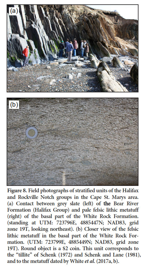
28 The Rockville Notch Group is represented only by the White Rock Formation in the Cape St. Marys area, where it is interpreted to be preserved in a synclinal structure (Fig. 7). On the coast it outcrops only on the western limb of the inferred structure and, along with adjacent rocks of the Halifax Group, it is highly sheared (Culshaw and Leisa 1997; Culshaw and Dickson 2015). At the exposed western contact, sheared and deformed slate and metasiltstone of the Halifax Group (Bear River Formation of White 2010a) are overlain by highly strained felsic metavolcanic rocks (Fig. 8a). The lithic metatuff at the base (Fig. 8b) apparently corresponds to the diamictite (tillite) of Schenk and Lane (1981), which they described as a pebbly, 1-m-thick mudstone. Long (2016) described these fragments as bombs, and U–Pb dat-ing confirmed the igneous origin of the unit and yielded an age of 442.9 ± 2.1 Ma (White et al. 2017a). The metatuff is in sharp contact with sheared and altered mafic metavolcanic rocks that are in places amygdaloidal. The mafic rocks are in sharp contact with thin felsic metatuff and thick quartzite, in which locally preserved cross-bedding confirms younging to the east. The quartzite is overlain by a section of mafic metavolcanic rocks more than 20 m thick. The section includes several flows with amygdaloidal tops and locally well preserved peperitic features in which the intermingled sedimentary rocks are quartz-rich metasandstone; the section includes a thin layer of cross-bedded metasandstone about 1 m thick. The metavolcanic rocks are in turn overlain by quartzite and tuffaceous quartzite in a section about 40 m thick. They grade upward into slate with abundant quartzite beds and lenses. The slate was interpreted by Long (2016) to belong to the Kentville Formation. It locally contains unidentified trace fossils. A mafic rock exposed in a separate outcrop in the beach consists of pyroxene-bearing gabbro and appears to be a younger dyke or sill, in contrast to the volcanic interpretation of Long (2016), who assigned it to the New Canaan Formation. The White Rock Formation is not exposed on the eastern limb of the syncline, although the distribution of units in the Halifax Group is consistent with that structure (Culshaw and Leisa 1997; White et al. 2001). The White Rock Formation, as exposed on the shore at Cape St. Marys, is about 140 m thick.
 Display large image of Figure 7
 Display large image of Figure 8
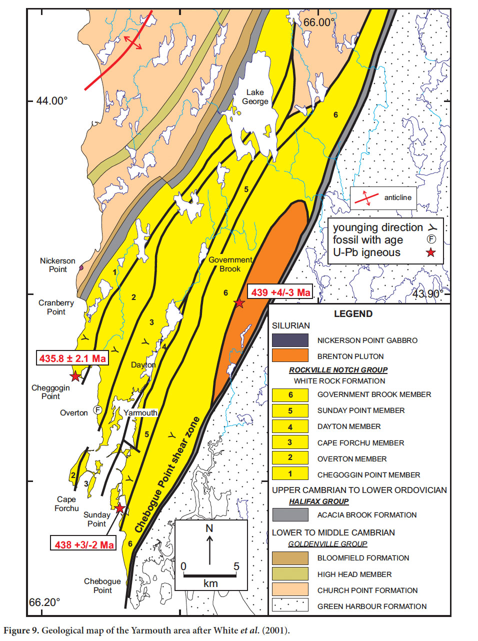
Yarmouth area
29 As at Cape St. Marys, the Rockville Notch Group in the Yarmouth area is represented by only the lowermost part of the White Rock Formation (Fig. 9). It forms a northeast-trending belt with a maximum width of about 15 km in the well-exposed coastal section. The southeastern margin is in faulted contact with slate that may belong to the Halifax Group (Fig. 9). The fault is inferred to be a brittle structure that juxtaposes chlorite- and biotite-grade rocks of the Halifax Group against staurolite-grade, typically schistose rocks of the White Rock Formation. However, in the coastal section north of Chebogue Point, the metamorphic grade in the White Rock Formation appears lower than in the same unit to the north, and the rocks are less sheared than those of the adjacent Halifax Group. The brittle fault is located within the broader Chebogue Point shear zone of Culshaw and Liesa (1997), previously referred to as the Deerfield shear zone by Keppie and Dallmeyer (1995), that affects both the White Rock Formation and the older rocks.
 Display large image of Figure 9
30 On the northwest margin, the position of the contact between the White Rock Formation and Halifax Group is poorly defined because of lack of exposure, both inland and on the coast. The most southerly outcrops of Halifax Group slate at Cranberry Point are separated by nearly 3 km, with no outcrop from the most northerly outcrop of metasedimentary rocks assigned to the White Rock Formation. The contact position is inferred by a strong aeromagnetic signature that appears to be associated with the Halifax Group. The Halifax Group and possibly the adjacent White Rock Formation in that area are deformed in the Cranberry Point shear zone (Culshaw and Leisa 1997).
31 The White Rock Formation in the Yarmouth area has been metamorphosed to amphibolite facies, and the combined effects of metamorphism and deformation have obscured primary sedimentary and volcanic features in many outcrops. However, macroscopic relict igneous features such as phenocrysts, amygdales, lithic and crystal clasts, and bombs indicate that the metavolcanic units include both flows and metatuffaceous rocks. Possible pillow structures are preserved locally and, overall, the sequence appears to have been deposited in a mainly subaqueous setting, with minor subaerial eruptions suggested by coarsely vesicular mafic flows and rare ignimbritic felsic units that contain vestiges of flow-banding and flattened pumice fragments. Some basaltic flows preserve amygdaloidal tops, and sedimentary and reworked metatuffaceous units locally preserve cross-bedding and graded bedding that enable the determination of younging direction. The White Rock Formation in the Yarmouth area previously has been interpreted to occur in a synclinal structure (Taylor 1967; Lane 1979; Hwang 1985; Culshaw and Liesa 1997; MacDonald 2000). However, White et al. (2001) and MacDonald et al. (2002) reported that the rocks appear to be consistently right-way-up and younging to the southeast, without repetition of distinctive lithologic units. Hence the rocks are divided into six fault-bounded members with clear stratigraphy within each member, but uncertain stratigraphic relations between members (Fig. 9). The members may be in part laterally equivalent. Overall, the rock types are like those preserved in the Cape St. Marys section, but much thicker (minimum ~ 6 km).
32 At the base of the Chegoggin Point member is a tuffaceous metasandstone and metasiltstone beds with calcsilicate beds and lenses. Upward, these rocks become interlayered with laminated phyllite and slate, the latter containing as yet unidentified trace fossils. The phyllite and slate grade upward into metasiltstone with distinctive garnetiferous schist layers up to 2 m thick that contain locally abundant chloritoid, and are associated with sulphide-rich metasandstone layers. Thick-bedded, massive to well-laminated quartzite occurs near the top of the unit (Figs. 10a, b). Above the quartzite is a mainly mafic metavolcanic member. The lower part consists of mafic crystal and lithiccrystal metatuff interlayered with minor intermediate to felsic crystal to crystal-lithic metatuff and metabasaltic flows with relict pillow-like textures (Fig. 10c). It also includes a boudinaged quartzite layer like those in the underlying unit. Zircon grains from a sample of felsic crystal-lithic metatuff yielded a concordia age of 435.8 ± 2.1 Ma (White et al. 2017a, b). The metavolcanic rocks are overlain by tuffaceous metasandstone interlayered with thinly bedded metasiltstone and metasandstone. These rocks grade upward into andesitic lithic to lithic-crystal metatuff.
 Display large image of Figure 10
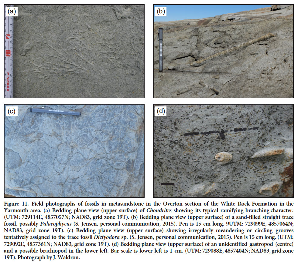
33 In its lower part, the Overton member consists of mafic flows and lithic metatuffs. The middle part consists of well-laminated metasiltstone and metasandstone, locally interlayered with amphibole-rich tuffaceous metasandstone and mafic flows and crystal metatuff, and includes a massive rusty quartzite layer 2 m wide. The metasandstone sequence contains calc-silicate lenses, abundant trace fossils such as Chondrites, Teichichnus, and Palaeophycus, and rare brachiopod and gastropod shells (Figs. 11a–d). The trace fossil assemblage does not provide any significant age constraints or palaeogeographic information (S. Jensen, written communication, 2017). A castellated rhynchonellid brachiopod from this area has a maximum age of Caradocian (Late Ordovician), but it is probably much younger (A. Boucot, personal communication, 1971 in Lane 1975). Several brachiopod and gastropod specimens were recollected from the same location and the fossil assemblage was reassigned to “no older than Early Silurian” (A. Boucot, written communication, 2001). Upsection, the metasedimentary package is in sharp contact with a thick package of mafic lithic to lithic-crystal metatuff and associated flows interlayered with minor tuffaceous metasandstone. The uppermost part of the member contains intermediate crystal metatuff and metaconglomeratic layers.
 Display large image of Figure 11
34 The Cape Forchu member is dominantly mafic metavolcanic rocks. The lower part consists of massive flows and mafic lithic metatuff, locally interlayered with tuffaceous metasandstone. The middle part of the unit is well exposed at Cape Forchu and consists of thinly bedded mafic lithic metatuff and tuffaceous metasandstone with well-preserved original volcanic and sedimentary features, and minor calc-silicate lenses. The upper part of the unit is separated from the middle part by a shear zone and consists of massive mafic flows and lithic to crystal-lithic metatuff. Locally the flows contain pillow-like structures and brecciated flow tops.
35 The Dayton member comprises mainly metasedimentary rocks. The lower part consists of thickly bedded metasandstone with abundant calc-silicate nodules and interbedded biotite-spotted slate. The middle part consists of biotite-spotted slate interbedded with metasiltstone and, near the top of the unit, the metasedimentary rocks are interlayered with mafic lithic metatuff and flows and tuffaceous metasandstone.
36 The Sunday Point member is in gradational contact with the metasedimentary rocks of the Dayton member and is a sequence of mafic lithic metatuff and flows interlayered with minor tuffaceous metasandstone. The mafic flows locally contain peperite-like structures, and many have amygdaloidal upper parts, 1–2 m wide, that indicate younging to the east. Cross-bedding and graded bedding in metasand-stone layers also indicate younging to the east. The member contains two distinctive felsic crystal-metatuff layers, each about 10 m thick. The lower felsic layer can be traced inland for several kilometres in sporadic outcrops. The upper felsic layer yielded a U–Pb (zircon) age of 438 +2/-3 Ma (Mac-Donald et al. 2002).
37 The Government Brook member contains a mixture of metasedimentary and metavolcanic rocks. Through most of the unit, the metasedimentary rocks are staurolitebearing micaceous phyllite and schist locally interlayered with thin horizons (<30 cm thick) of metasandstone and amphibolite. The metavolcanic rocks are mafic to rarely intermediate lithic metatuff interlayered with tuffaceous metasandstone, and occur in a central belt flanked by metasedimentary rocks. Exposures along the coastal sec-tion north of Chebogue Point are unlike inland exposures of the unit in that they lack phyllite and schist, and consist of metasiltstone and metasandstone with interlayered mafic rocks that could be either flows or sills. No evidence for younging direction was observed, and these rocks appear to be in faulted contact with more deformed slate of the Halifax Group to the east (Fig. 9).
STRATIGRAPHIC COMPARISONS
38 The simplified stratigraphic columns in Figure 12 summarize the rock types and age constraints in the five separate areas where the Rockville Notch group is preserved, as described above. Although the thickest succession is in the Yarmouth area, the White Rock Formation there appears to be entirely of early Silurian (Llandovery) age; U–Pb (zircon) dates from units interpreted to be near the bottom and top of the formation overlap within error and also overlap with the age of 439+4/-3 Ma for the granitic Brenton pluton (Keppie and Krogh 2000). Although located in a shear zone that obscures relationships, the presence of granitic sheets in the Government Brook member suggests an intrusive relationship (White et al. 2001; MacDonald et al. 2002). The much thinner succession in the Cape St. Marys area is also of Early Silurian age (Fig. 12), based on the U–Pb age of 442 ± 2.1 for a metatuff at the base of the section (White et al. 2017b) and the presence of a folded gabbroic sill with an age of 426 ± 2 Ma (Warsame et al. 2017) which places a minimum age on the host rocks.
 Display large image of Figure 12
39 It is likely that the sections in neither the Wolfville nor Bear River extend into rocks as old as the metavolcanic components of the White Rock Formation in the Torbrook, Cape St. Marys, and Yarmouth areas. The previous interpreta-tions that used the quartzite units to characterize the White Rock Formation are supported by the present work, but the assumption of a lower and upper quartzite separated by slate (Crosby 1962) is an over-simplification, even in the Wolfville map area where it was first suggested. Quartz-ite occurs throughout the White Rock Formation in the Wolfville and Torbrook areas and at higher levels in the stratigraphy in the Bear River area (Fig. 12).
40 The age constraints, including fossils, preclude the correlation between the upper part of the metavolcanic sequence in the Yarmouth area and the New Canaan Formation of the Wolfville area as proposed by of Schenk (1995b) (Fig. 12). The stratigraphic constraints indicate a hiatus in igneous activity between that in the lower part of the White Rock Formation (ca. 440 Ma) and the Upper Silurian–Lower Devonian New Canaan Formation, with the exception of a mafic metatuff locally at the top of the White Rock Formation in the Torbrook area (Fig. 12). Perhaps the initial rifting of Meguma from Gondwana failed in the early Silurian, resulting in a continued shallow-water setting during deposition of the overlying formations. The renewed volcanic activity in the Early Devonian could indicate the actual time of separation of the Meguma terrane from the Gondwanan continent.
DEPOSITIONAL ENVIRONMENT AND PROVENANCE OF THE ROCKVILLE NOTCH GROUP
41 Earlier workers (e.g. Schenk 1972, 1995b; Lane 1975, 1979) interpreted that the depositional environment for the White Rock Formation was strongly influenced by continental glaciation. Many of the sedimentary features were interpreted to be related to glacially induced sea-level changes (Lane 1975, 1979). The scarcity of fossils was interpreted as the result of harsh cold-water conditions (Schenk 1975) and clasts in the metaconglomeratic and lithic metatuff beds in the lower part of the formation were interpreted as dropstones (Schenk 1972; Lane 1975, 1979; Schenk and Lane 1981). However, Long (1991, 1992, 1994) provided evidence for a non-glacial origin for the diamictite units, and paleontological evidence and U–Pb age con-straints (e.g., White et al. 2017a) indicate that deposition of the White Rock Formation took place through the early part of the Silurian, by which time continental glaciation had ceased in North Africa (Paris et al. 2000) and elsewhere in the circum-Rheic region (Melchin and Holmden 2006).
42 The metavolcanic rocks in the White Rock Formation are predominantly subaqueous, as indicated by pillow basalts and other waterlain features observed in the associated metatuffaceous rocks, although some felsic metavolcanic rocks display flow-banding and weathered tops that suggest subaerial deposition (Lane 1975, 1979; Schenk 1997; Mac-Donald et al. 2002). Based on the depositional characteristics of the sedimentary units, Lane (1975, 1979) suggested that the White Rock Formation formed in marine waters less than 200 m but more likely less than 20 m deep. Schenk (1991, 1995b, 1997) considered that the sedimentary rocks record a storm-influenced inner shelf with water depth between storm- and fair-weather wave base.
43 Upsection, the base of the Kentville Formation was interpreted to record water depth greater than storm wave base and deposition on the outer continental shelf, the result of rapid transgression following deglaciation (Schenk 1991, 1997; Lane 1979). This was followed by coarsening of the sedimentary succession and shallowing of water levels on the shelf as the seas warmed (Schenk 1991, 1997). Rocks of the Torbrook Formation represent a storm-dominated succession (Smitheringale 1973) proximal to an ancient shoreline (Jensen 1975), recording several episodes of transgression and regression (Schenk 1991, 1995b, 1997). Recent work by Marshall (2011) suggested that the Tor-brook Formation accumulated in storm-dominated, middle and distal shelf environments between fair-weather and storm wave base in deeper water than was postulated by Jensen (1975) and Schenk (1991, 1995b).
44 The New Canaan Formation, at least in part laterally equivalent to the Torbrook Formation, was deposited in a volcanic-island environment with marginal carbonate-reef facies (Smith 1992). James (1998) further suggested that the alternating volcanic and carbonate sequences in the formation may be the result of deposition in an extensional intracontinental basin.
45 Overall, the sedimentary units of the Rockville Notch Group are interpreted to record relatively shallow, warm-water deposition in a continental shelf setting, with periods of transgression and regression, and times of subaerial exposure. The presence of volcanic rocks in the Rockville Notch Group suggests that the source of iron for the ironstone beds may have been from contemporaneous volcanic activity or the chemical weathering of laterites during the warm Silurian and Early Devonian climate (e.g., Mar-shall 2011). However, the presence of abundant phosphate with the ironstone beds are more consistent with a model of warm water interacting with upwelling, ferruginous anoxic, deep cold waters (e.g., Poulton and Canfield 2011) and would provide a primary source of Fe2+ and PO43- to the oxygenated shelf environment (e.g., Pufahl 2010; Dunn 2017). The anomalous concentrations of manganese observed in the lower part of the White Rock Formation and presence of possible SEDEX deposits in the New Canaan Formation can also be explained by this upwelling model (Hein et al. 2004; Simandl et al. 2012).
46 Paleocurrent directions are variable in the Rockville Notch Group and not easy to interpret due to deformation and metamorphism. However, based on decreasing sandstone-bed thicknesses in the White Rock Formation, Crosby (1962) and Lane (1979) suggested a source area from the present east or northwest, respectively. In comparison, current direction in the Torbrook Formation var-ied from northwest, southeast, north, and south (Jensen 1975; Schenk 1995b, 1997). The thickness of the Rockville Notch Group required a large volume of sediment, which led Schenk (1995b) to postulate a source area that was continental in scale. The presence of abundant quartzite and other quartz-rich siliciclastic rocks throughout the group confirms a continental provenance. Based on sediment dispersal patterns and the similarity in sandstone mineral-ogy in the Goldenville and Halifax groups with those in the Rockville Notch Group Schenk (1995a, b, 1997) concluded that all three groups were probable derived from the same source area, the West African craton. Detrital zircon data from metasedimentary samples support this interpretation, showing that the major sediment sources for the White Rock Formation have ages of ca. 670–550 Ma and ca. 2050 Ma, similar to ages from the underlying Goldenville and Halifax groups (White et al. 2017b). This detrital zircon record indicates that the palaeoposition of Meguma was close to Cadomia and West Africa from at least the early Cambrian through the Early Silurian.
GEOCHEMISTRY OF METAVOLCANIC UNITS IN THE ROCKVILLE NOTCH GROUP
47 Chemical data from metavolcanic rocks and related dykes and sills in the White Rock Formation in the Yarmouth area were presented by MacDonald (2000), Mac-Donald et al. (2002), and White and Barr (2004), updating the earlier work by Sarkar (1978). However, chemical data from metavolcanic units elsewhere in the Rockville Notch Group are sparse. Trapasso (1979) focused mainly on sills and dykes, and her few analyses of metavolcanic rocks in the White Rock Formation in the Torbrook area contain a limited suite of trace elements. Keppie and Dostal (1980) showed diagrams with chemical data from the White Rock Formation but those data were not published with the paper and sample locations were not provided. Kendall (1981) presented major element and limited trace element data for five metavolcanic samples from the Cape St. Marys section. Keppie et al. (1997) included whole-rock chemical analyses for three basalt and rhyolite samples from the White Rock Formation in the Torbrook area, and one basalt sample from the section at Cape St. Marys. They pointed out some differences between the data from the two areas, but the limited dataset impeded interpretations.
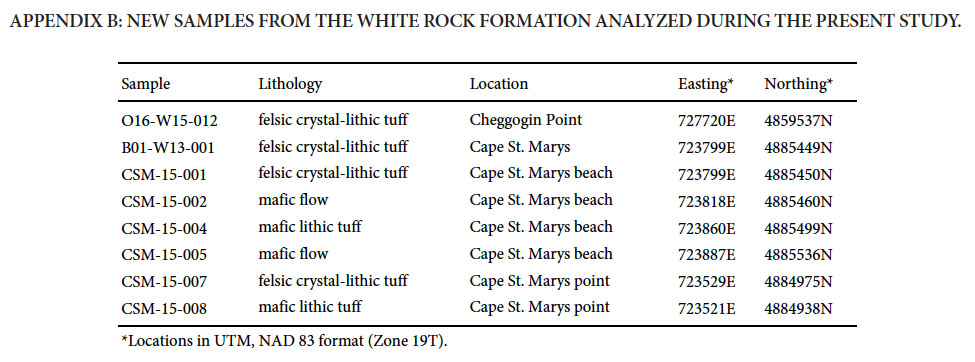
48 To provide enhanced information about the chemical characteristics of the metavolcanic rocks we compiled data from the work of Trapasso (1979) and Hagan (2002) in the White Rock Formation in the Torbrook area and James (1998) in the New Canaan Formation in the Wolfville area (Appendix A). Powders from ten of these samples were analyzed for rare-earth elements. In addition, new whole-rock data were obtained for eight samples from the Cape St. Marys and Cheggogin Point sections (Appendix A and B).
49 As shown by MacDonald et al. (2002) for the Yarmouth area, the metavolcanic rocks in the White Rock Formation overall are bimodal, but mafic rocks are much more abun-dant than felsic rocks; the New Canaan Formation contains only mafic rocks (Fig. 13). A few metatuffaceous rocks of intermediate (57% to 68% SiO2) composition have been analysed from the White Rock Formation in both the Yar-mouth and Torbrook areas (Fig. 13). Many of the samples are intensely altered, with high carbonate and chlorite contents and correspondingly high loss on ignition. Hence the major element oxides were recalculated to 100% volatile-free before plotting on the variation diagrams. Even so, they show considerable scatter (Figs. 13a–d). The typically more immobile trace elements also show a spread from subalkalic to alkalic compositions in both mafic and felsic samples (Fig. 13e).
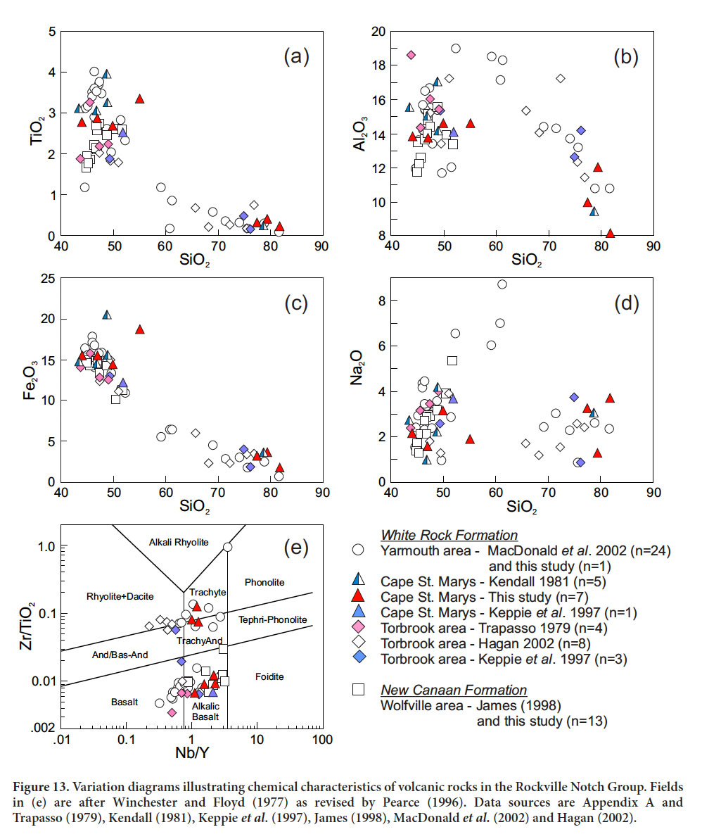 Display large image of Figure 13
50 Mafic rocks from the Yarmouth area tend to have lower Nb/Y ratios and higher TiO2 than those from the other areas, but most mafic samples from all areas have within-plate alkalic characteristics on various discrimination diagrams for mafic rocks (Figs. 14a–d). The New Canaan Formation samples tend to be more alkalic than those from the older metavolcanic rocks of the White Rock Formation (Figs. 13e, 14b). Chondrite-normalized rare-earth element (REE) patterns show light REE enrichment (La 60 to 250 times chondritic values; Fig. 15a) with the most enrichment in the New Canaan Formation samples. Patterns are smoothly sloping with no or slight Eu anomalies. Such patterns are typical of within-plate tholeiitic to alkalic mafic rocks (e.g., Winter 2010).
 Display large image of Figure 14
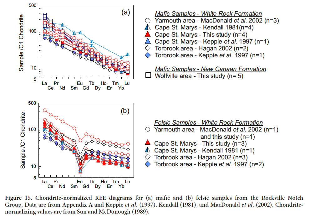 Display large image of Figure 15
51 Felsic samples from the Yarmouth area and Cape St. Marys appear more alkalic than those from the Torbrook area, which have lower Nb/Y ratios (Fig. 13e). The Yarmouth area samples tend of have higher Nb, so they plot more in the within-plate granite field compared to felsic samples from the other two areas (Figs. 14a, b). The REE patterns show light REE enrichment and strong negative Eu anomalies (Fig. 15b). The additional chemical data from felsic samples in the Cape St. Marys and Torbrook areas are consistent with those from the Yarmouth area, interpreted by MacDonald et al. (2002) to be within-plate anorogenic felsic rocks derived from similar sources as the Devonian granitic rocks of the Meguma terrane and consistent with the tectonic setting indicated by the associated mantle-derived mafic rocks (Figs. 16a, b). The igneous activity may have occurred in response to extension as the Meguma terrane rifted away from Gondwana in the Early Silurian.
 Display large image of Figure 16
COMPARISON WITH THE ARISAIG GROUP
52 As a result of U–Pb (zircon) dating in the 1980s and 1990s, it was recognized that igneous rocks of Silurian age are a more significant component of the northern Appalachian orogen than had been previously thought (e.g., Chandler et al. 1987; Dunning et al. 1990; Bevier and Whalen 1990; Doig et al. 1990; Barr and Jamieson 1991). Their widespread distribution led to the suggestion that they represent an overstep sequence, with the implication that the terranes of the orogen were assembled along the Laurentian margin by the Silurian (e.g., Chandler et al. 1987; Keppie and Krogh 2000; Lynch 2001). In particular, a link was suggested between the Rockville Notch Group of the Meguma terrane and the Arisaig Group of the Avalon terrane in the Antigonish Highlands (Boucot et al. 1974; Schenk 1975; Keppie and Krogh 2000; Murphy et al. 2004). Murphy et al. (2004) used the inferred stratigraphic continuity between the Halifax Group and White Rock Formation as evidence for a connection between the Meguma and Avalon terranes extending back to the Late Neoproterozoic, although it is now recognized that the units are separated by a depositional gap of at least 25 million years (White et al. 2017a, b).
53 The Silurian to Early Devonian Arisaig Group in the Antigonish Highlands (Fig.1) consists of an 1800–1900-m-thick sequence of shallow marine mudstone, siltstone, and sandstone divided into several formations (Fig. 17) (e.g., Boucot et al. 1974; Benson 1974; Murphy 1987; Murphy et al. 1991; Waldron et al. 1996). Bimodal volcanic rocks of the underlying Dunn Point and McGillivray Brook formations were considered co-genetic with the clastic units (e.g. Benson 1974) and later included in the lower part of the Arisaig Group (Murphy 1987; Murphy et al. 1991). However, the recognition that the volcanic rocks at Arisaig are Ordovician (Hamilton and Murphy 2004; Murphy et al. 2012), and hence 10–15 Ma older than the overlying sedimentary rocks, led to their removal from the Arisaig Group. Without the volcanic rocks, the similarity between the Rockville Notch and Arisaig groups is minimal (Fig. 17). Other than K-bentonite beds (Bergstrom et al. 1997), volcanic rocks are absent from the Arisaig Group. Although both groups accumulated in a marine environment and contain ironstone beds, the sedimentary sequences overall are different. The Arisaig Group section lacks the quartzite beds and lenses that are characteristic of the White Rock Formation (Fig. 17).
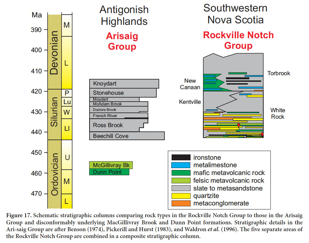 Display large image of Figure 17
54 The stratigraphic and chemical differences are further supported by detrital zircon provenance studies which showed that the Arisaig Group contains an abundance of Cambrian and Ordovician (520–440 Ma) zircon grains which are little represented in the Rockville Notch Group (White et al. 2017a, b), indicating differences in the sediment sources.
55 Basin subsidence analysis of the Arisaig Group by Waldron et al. (1996) suggested that basin formation and ini-tial subsidence in Avalonia during the Silurian was due to tectonic extension related to post-accretionary interaction between Avalonia and Laurentia. Analysis of the later evolution of the Arisaig basin showed the influence of a Late Devonian tectonic event, probably marked by oblique convergence between western Avalonia and the Meguma Terrane to the south (Waldron et al. 1996). Given the extent and impact of the ca. 400–390 Ma Neoacadian orogeny in the Meguma terrane and its relative absence in the Avalon terrane, it seems unlikely that the two terranes were fellow travellers in the Devonian.
CONCLUSIONS
56 By combining previously published stratigraphic and paleontological observations and interpretations from the Wolfville, Torbrook, Bear River, Cape St. Marys and Yarmouth areas with detailed mapping and U–Pb (zircon) igneous crystallization ages, we have developed a more complete understanding of the Rockville Notch Group. Although the five areas have stratigraphic elements in common, which suggest that they were part of the same depositional system, they also have differences. Volcanic rocks form the lower part of the White Rock Formation in three of the five areas, and U–Pb (zircon) dates indicate that the volcanism occurred over a relatively short span of a few mil-lion years in the Early Silurian. The bases of the sections in the other two areas may postdate that volcanic activity. Volcanism resumed in the Late Silurian-Early Devonian, but apparently was localized to the Wolfville area. Quartzite is a characteristic component of the White Rock Formation, but tends to form lenses that are not laterally correlative even in the Wolfville area, where they were first described.
We thank numerous colleagues and students who have contributed to the current understanding of the Rockville Notch Group. We are grateful to Sören Jensen for advice on trace fossil identifications at Overton. The Southwest Nova Scotia Mapping Project was funded by the Nova Scotia Department of Natural Resources (NSDNR) operating budget for Chris White. Rick Horne and numerous students contributed to the mapping and data processing of the western and southern half of the Meguma terrane. We thank Trevor MacHattie and journal reviewers Susan Johnson and Darrel Long for their insightful comments and suggestions, which improved the manuscript. This paper is published with the permission of the Director, Nova Scotia Department of Natural Resources. Sandra Barr’s work on this project was supported by Discovery grants from the Natural Sciences and Engineering Research Council of Canada.
APPENDIX A
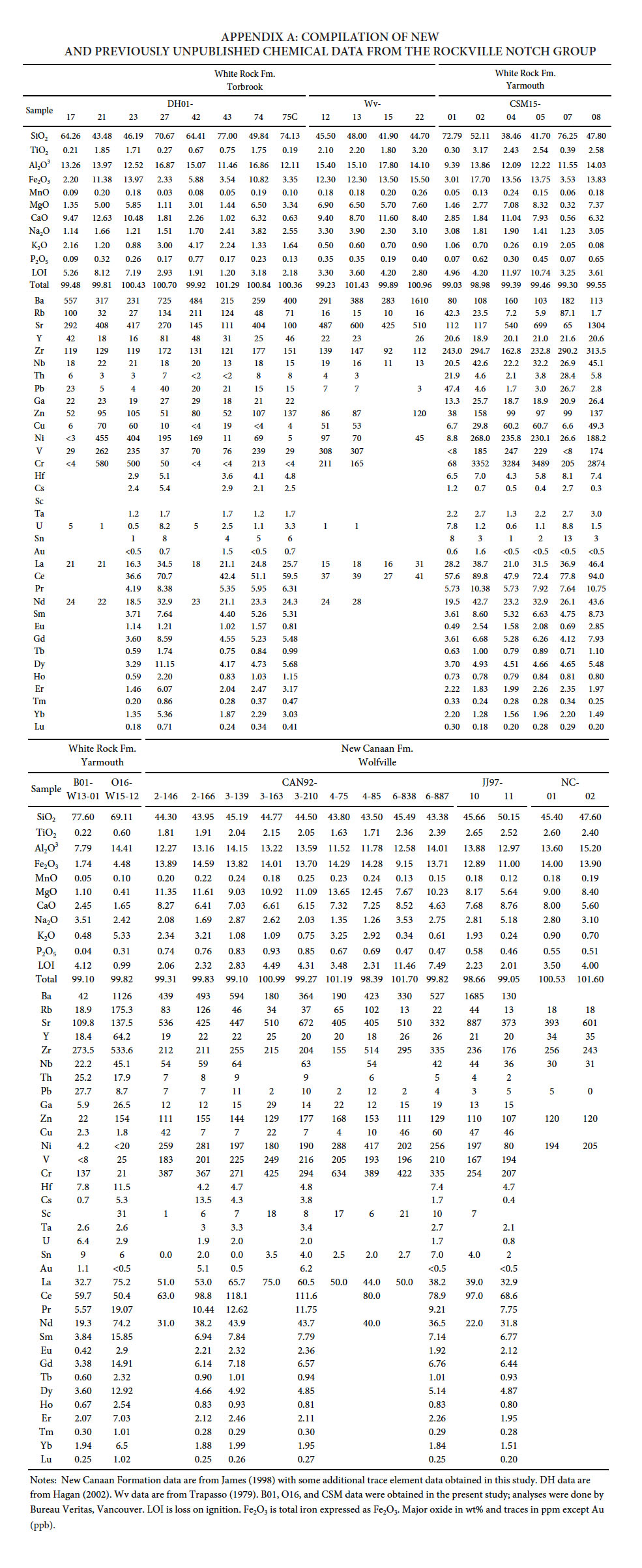 Display large image of Appendix ANotes: New Canaan Formation data are from James (1998) with some additional trace element data obtained in this study. DH data are from Hagan (2002). Wv data are from Trapasso (1979). B01, O16, and CSM data were obtained in the present study; analyses were done by Bureau Veritas, Vancouver. LOI is loss on ignition. Fe2O3 is total iron expressed as Fe2O3. Major oxide in wt% and traces in ppm except Au (ppb).
 APPENDIX B
 Display large image of Appendix B*Locations in UTM, NAD 83 format (Zone 19T).