Articles
Geological relationships and laser ablation ICP-MS U-Pb geochronology of the Saint George Batholith, southwestern New Brunswick, Canada:
implications for its tectonomagmatic evolution
ABSTRACT
The Late Silurian to Late Devonian Saint George Batholith in southwestern New Brunswick is a large composite intrusion (2000 km2) emplaced into the continental margin of the peri-Gondwanan microcontinent of Ganderia. The batholith includes: (1) Bocabec Gabbro; (2) equigranular Utopia and Wellington Lake biotite granites; (3) Welsford, Jake Lee Mountain, and Parks Brook peralkaline granites; (4) two-mica John Lee Brook Granite; (6) Jimmy Hill and Magaguadavic megacrystic granites; and (6) rapakivi Mount Douglas Granite. New LA ICP-MS in situ analyses of six samples from the Saint George Batholith are as follows: (1) U-Pb monazite crystallization age of 425.5 ± 2.1 Ma for the Utopia Granite in the western part of the batholith (2) U-Pb zircon crystallization ages of 420.4 ± 2.4 Ma and 420.0 ± 3.5 Ma for two samples of the Utopia Granite from the central part of the batholith; (3) U-Pb zircon crystallization age of 418.0 ± 2.3 Ma for the Jake Lee Mountain Granite; (4) U-Pb zircon crystallization age of 415.5 ± 2.1 Ma for the Wellington Lake Granite; and (5) U-Pb monazite crystallization age of 413.3 ± 2.1 Ma for the John Lee Brook Granite. The new geochronological together with new and existing geochemical data suggest that the protracted magmatic evolution of the Late Silurian to Early Devonian plutonic rocks is related to the transition of the Silurian Kingston arc-Mascarene backarc system from an extensional to compressional tectonic environment during collision of the Avalonian microcontinent with Laurentia followed by slab break-off.
RÉSUMÉ
Le batholite du Silurien tardif au Dévonien tardif de Saint George dans le sud ouest du Nouveau Brunswick est une vaste intrusion composite (2 000 kilomètres carrés) qui s’est mise en place à l’intérieur de la marge continentale du microcontinent périgondwanien de Ganderia. Le batholite englobe : (1) le gabbro de Bocabec; (2) les granites à biotite isogranulaire Utopia et du lac Wellington; (3) les granites hyperalcalins de Welsford, du mont Jake Lee et du ruisseau Parks Brook; (4) le granite à deux micas du ruisseau John Lee; (5) les granites macrocristallins de la colline Jimmy et de Magaguadavic; et (6) le granite rapakivi du mont Douglas. De nouvelles analyses par spectrométrie de masse à plasma induit couplée à l’ablation laser in situ de six échantillons provenant de Saint George ont révélé ce qui suit : (1) une cristallisation survenue il y a 425,5 ± 2,1 Ma d’après une datation U-Pb sur monazite, dans le cas du granite Utopia dans la partie occidentale du batholite; (2) des âges de cristallisation en vertu d’une datation U-Pb sur zircon de 420,4 ± 2,4 Ma et de 420,0 ± 3,5 Ma dans le cas de deux échantillons en provenance du granite Utopia dans le centre du batholite; (3) un âge de cristallisation de 418,0 ± 2,3 Ma dans le cas du granite du mont Jake Lee, d’après une datation U-Pb sur zircon; (4) un âge de cristallisation de 415,5 ± 2,1 Ma obtenu par datation U-Pb sur zircon dans le cas du granite du lac Wellington; et (5) un âge de cristallisation de 413,3 ± 2,1 Ma d’après une datation U-Pb sur monazite, dans le cas du granite du ruisseau John Lee. Les nouvelles données géochronologiques conjuguées aux données géochimiques existantes laissent supposer que l’évolution magmatique prolongée de des roches plutoniques du Silurien tardif au Dévonien précoce est apparentée à la transition de l’arc silurien de Kingston-arrière-arc de Mascarene d’un milieu tectonique de distension à un milieu de compression durant la collision du microcontinent avalonien avec Laurentia suivie d’une rupture par tranches.
[Traduit par la redaction]
INTRODUCTION
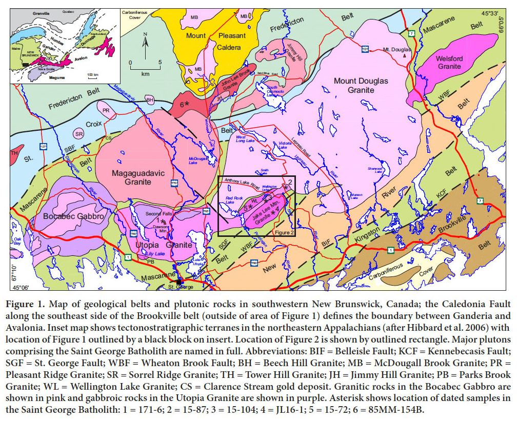
1 The Silurian (Ludlovian to Pridolian) to Late Devonian (Famennian) Saint George Batholith in southwestern New Brunswick is a large composite intrusion (2000 km2) that was emplaced into the margin of the peri-Gondwanan microcontinent of Ganderia (Fig. 1). The batholith and associated Silurian volcanic and sedimentary rocks of the Mascarene belt are situated along the boundary between Precambrian Ganderian basement rocks of the New River and Brookville belts to the southeast and Ganderian passive margin Cambrian-Ordovician sedimentary rocks of the St. Croix belt to the northwest (Fyffe and Riva 1990; van Staal et al. 2009; Fyffe et al. 2011). The presence of Proterozoic marble and quartzite in the Brookville belt distinguishes it from the Neoproterozoic volcanic and comagmatic plutonic rocks of the New River belt (Johnson and McLeod 1996; White and Barr 1996). The St. Croix belt is a highly deformed Cambrian-Ordovician (Tremadocian to Sandbian) sequence of shale, wacke, and quartzose sandstone; the Fredericton belt is a thick Silurian (Llandoverian to Ludlovian) sequence of wacke, shale, and calcareous sandstone (Ruitenberg 1967; Fyffe and Riva 2001; Castonguay et al. 2003; Thorne et al. 2008). The precise nature of the contact between the St. Croix and Fredericton belts is difficult to discern in the field due to poor exposure, complex deformation, and similarity of lithotypes. The contact has been interpreted as a northwest-directed thrust, referred to as the Honeydale Fault (Ruitenberg 1967).
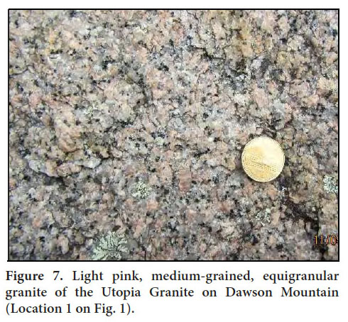
 Display large image of Figure 1
2 Silurian (Llandoverian) volcanic and comagmatic plutonic rocks of the Kingston belt separate the Brookville belt from the New River belt. Felsic volcanic rocks in the Kingston belt have yielded U-Pb zircon ages ranging from 442 to 436 Ma, and associated felsic plutonic rocks, ranging from 437 to 435 Ma (Doig et al. 1990; Barr et al. 2002; McLeod et al. 2003). These volcanic and plutonic rocks are interpreted, based on geochemical characteristics, to represent remnants of a Silurian volcanic arc that formed above a subduction zone dipping to the northwest beneath the New River belt (Fyffe et al. 1999; Barr et al. 2002; White et al. 2006). The shallow marine to subaerial sedimentary and volcanic sequences of the Silurian (Llandoverian to Pridolian) Mascarene belt, lying to the northwest of the Kingston belt, are interpreted to have been deposited in a backarc basin that opened behind the Kingston arc (Fyffe et al. 1999; Barr et al. 2002). Felsic volcanic rocks from the Mascarene belt have yielded U-Pb zircon ages ranging from 438 to 423 Ma (Miller and Fyffe 2002; Van Wagoner et al. 2002).
3 Based on field relationships and geochronological data, McLeod (1990) divided the Saint George Batholith into the following units from oldest to youngest (Fig. 1): Bocabec Gabbro – greyish green, locally layered, medium-grained gabbro and minor associated granitic rocks; Utopia Granite – typically red, leucocratic, medium- to coarse-grained, equigranular, biotite granite; Welsford, Jake Lee Mountain, and Parks Brook granites – beige to pink, mediumgrained and equigranular to fine-grained and porphyritic, amphibole-bearing, peralkaline granites; Magaguadavic Granite – greyish pink, coarse-grained, megacrystic granite; John Lee Brook Granite – light grey, medium-grained, equigranular, garnetiferous, two-mica granite; and Mount Douglas Granite – light pink, medium-to-coarse-grained and equigranular to fine-grained and porphyritic, rapakivitextured, biotite granite. Geochronological data available to McLeod (1990) included: U-Pb zircon ages from the Utopia (430 ± 3 Ma), Welsford (422 ± 1 Ma), and Magaguadavic (396 ± 1 Ma) granites; an 40Ar/39Ar muscovite age of 384 ± 7 Ma from the John Lee Brook Granite; and U-Pb monazite ages from the Mount Douglas granite (367 ± 1 Ma, 366 ± 1 Ma).
4 To provide additional crystallization ages for the plutons comprising the Saint George Batholith, six samples were selected for laser ablation inductively coupled plasma-mass spectrometry (LA ICP-MS) analysis at the University of New Brunswick’s Department of Earth Sciences. The U-Pb geochronological work was coordinated with field mapping of the Saint George Batholith by the Geological Surveys Branch of the New Brunswick Department of Energy and Resource Development during the summers of 2015 and 2016. Dated sample sites (Locations 1 through 6, numbered from oldest to youngest age of crystallization) are shown on Figure 1 and Figure 2. Locations 1, 4, 5 and 6 are in the Utopia, Jake Lee Mountain, Wellington Lake (new name), and John Lee Brook granites, respectively. Locations 2 and 3, previously mapped as part of the Mount Douglas Granite and Jake Lee Mountain Granite, respectively (McLeod 1990, McLeod et al. 1998), are here assigned to the Utopia Granite on the basis of new field mapping (see below).
 Display large image of Figure 2
FIELD OBSERVATIONS
5 In 2015, geochronological analysis of an archived sample from the John Lee Brook Granite indicated that this twomica granite is older than the megacrystic Magaguadavic Granite rather than younger as previously suggested (McLeod 1990). Field work was therefore undertaken in the summers of 2015 and 2016 to resolve the conflict between the previously interpreted intrusive history of the Saint George Batholith and the new geochronological data. Contact relationships between the various plutons comprising the Saint George Batholith were examined and the new findings are reported below and incorporated into the revised regional map of the batholith (Fig. 1). Detailed mapping of contacts between intrusive and country rocks during our recent mapping has also better defined the areal distribution and geometry of the plutons comprising the batholith. Previous maps depicted the Saint George Batholith as a contiguous assemblage of intrusions that were emplaced over an extended period of time to form a single massive body. The new mapping, however, suggests that the batholith is more realistically comprised of a loose cluster of distinctive plutons that intruded mainly into sedimentary and volcanic host rocks rather than into previously consolidated intrusive bodies (Fig. 1).
6 McLeod (1990) recognized and named the poorly exposed John Lee Brook Granite as a distinct pluton during his mapping of the Saint George Batholith. It is a mediumgrained, equigranular, garnetiferous, two-mica granite, underlying an area of about 50 km2 along the northern margin of the batholith just south of the Late Devonian Mount Pleasant Caldera (Thorne et al. 2013). The 40Ar/39Ar muscovite age of 384 ± 7 Ma from the John Lee Brook Granite together with the reported presence of white microgranitic veins cutting the adjacent Magaguadavic Granite, dated by U-Pb on zircon at 396 ± 1 Ma (Bevier 1990), suggested that the former was younger than the latter (McLeod 1990). However, dating of sample 85MM-154B, collected by McLeod (1990) from near the headwaters of John Lee Brook, yielded a crystallization age of 413 ± 2 Ma (Location 6 on Fig. 1) casting doubt on the above interpretation.
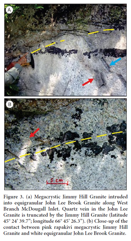
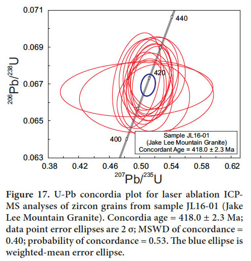
7 Field observations undertaken in the summer of 2015 on a small isolated body of megacrystic granite exposed along the upper reaches of McDougall Inlet, west of South Oromocto Lake (Fig. 1), indicate that the megacrystic granite intrudes and truncates quartz veins and aplitic dykelets within the John Lee Brook Granite (Fig. 3a). This isolated body is considered herein to be part of the larger Jimmy Hill Granite (Fig. 1), which underlies the South Oromocto Lake area to the east of McDougall Inlet; McLeod (1990) previously included the granite in the South Oromocto Lake area as part of the Magaguadavic pluton. A close-up photograph of the outcrop along McDougall Inlet clearly shows pink megacrysts of potassium feldspar with rapakivi mantling characteristic of the Jimmy Hill Granite in contact with the equigranular John Lee Brook Granite (Fig. 3b). The observed cross-cutting relationship confirms that both the megacrystic Jimmy Hill and Magaguadavic plutons, dated at 403 ± 2 Ma and 396 ± 1 Ma, respectively (Bevier 1990; Davis et al. 2004), are younger than the John Lee Granite in agreement with new age determination obtained on the latter (see below).
 Display large image of Figure 3
8 Geophysical maps of the St. George area clearly outline the Magaguadavic pluton in the McDougall Lake area as a prominent, circular magnetic feature (King and Barr 2004). This magnetic signature has been used to draw contacts on previously published bedrock maps that enigmatically suggest that the Early Devonian megacrystic granite of the Magaguadavic pluton cross-cuts the adjacent Late Devonian rapakivi granite of the Mount Douglas pluton. However, the recent field mapping has shown that the two plutons are separated by a screen of sedimentary rocks from 300 to 400 m wide and so do not come into direct contact with one another as shown on earlier maps; thus, the Magaguadavic pluton in this area intruded sedimentary and volcanic rocks along its eastern margin – Ordovician quartzose sandstone of the Kendall Mountain Formation (Cookson Group) in the north and Silurian siltstone and mafic volcanic tuff assigned to the Jones Creek Formation (Mascarene Group) in the south – and the Mount Douglas pluton intruded the same screen of sedimentary and volcanic rocks of Jones Creek Formation along its western margin (Fig. 1). More details on the stratigraphy of the Mascarene Group are given below under the discussion on the tectonic evolution of the Mascarene backarc basin.
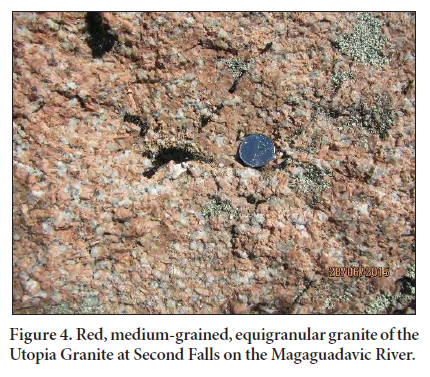
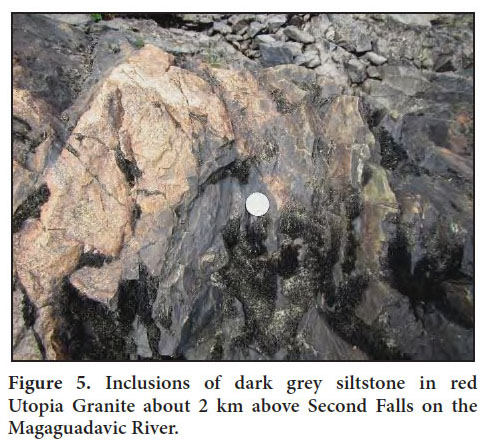
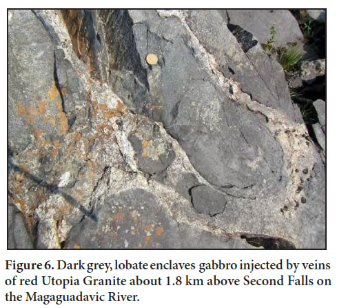
9 The Utopia Granite underlies an area of about 100 km2 along the southern margin of the Saint George Batholith. The northern margin of the Utopia pluton is separated from the southern margin of the Magaguadavic pluton by a screen from 300 to 600 m wide of dark grey siltstone and minor mafic tuff of the Silurian Jones Creek Formation exposed above Second Falls on the Magaguadavic River (Figs. 1, 4, and 5). Gabbroic rocks, exposed a short distance down river to the south, are injected by red granitic dykelets characteristic of the Utopia Granite; the granitic dykelets surround clusters of lobate gabbroic enclaves, many of which have fine-grained margins, suggesting that emplacement of the two magma types was essentially contemporaneous (Fig. 6). Similar magma mingling has been observed in the main part of the Bocabec Gabbro in the Oak Bay area (Fig. 1) farther to the southwest and in the Moosehorn Plutonic Suite in adjacent Maine (Fyffe 1971; McLaughlin et al. 2003). Note, however, that the new mapping suggests that a sedimentary screen exists between the Utopia and Bocabec plutons (Fig. 1), casting doubt on previous map interpretations showing a direct physical connection between gabbroic rocks in the Utopia pluton and those of the adjacent Bocabec pluton.
 Display large image of Figure 4
 Display large image of Figure 5
 Display large image of Figure 6
10 Bevier (1990) and Barr et al. (2010) reported U-Pb zircon ages of 430 ± 3, 428 ± 1, and 426 ± 6 Ma from samples of red Utopia Granite collected near the northern end of Lake Utopia (Fig. 1). These late Wenlockian to Ludlovian ages, according to the time scale of Ogg et al. (2016), seemed too old given that fossil evidence from sedimentary rocks in Maine indicate a Pridolian age (Churchill-Dickson 2004) for the surrounding Eastport Formation (Mascarene Group) and that felsic volcanic rocks in the Eastport Formation in New Brunswick have yielded a preliminary U-Pb zircon age of 423 ± 1 Ma (Van Wagoner et al. 2002). However, the recent field mapping indicates that the Utopia pluton near the above dated granite may have been emplaced no higher in the stratigraphic section than the Llandoverian to Wenlockian Jones Creek Formation (Mascarene Group). To further investigate the age of the Utopia Granite, sample 171-6 was collected from a distinctive, light pink granite (Martin 2013) exposed on the summit of Dawson Mountain (Fig. 7) to the northwest of Lake Utopia (Location 1 on Fig. 1).
 Display large image of Figure 7
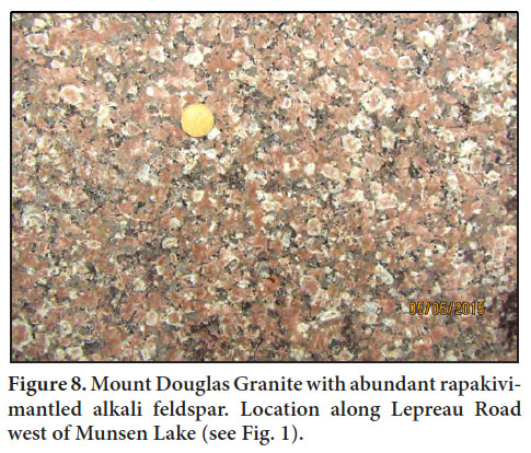
11 Field mapping was conducted in the Red Rock Lake area to the northeast of Lake Utopia (Fig. 1) to better delineate the contact between the Silurian Utopia Granite and Late Devonian Mount Douglas Granite. Distinguishing between these two granites can be difficult in places as both can vary from red to pink. However, as documented by Cherry and Trembath (1978), the granitic rocks in the Lake Utopia area are homogeneous, equigranular, and medium- to coarse-grained, whereas those in the Mount Douglas area are heterogeneous consisting of about 65% equigranular, medium- to coarse-grained phase and about 35% finegrained porphyritic and aplitic phases. In addition, rapakivi-mantling of potassium feldspar is common in the granitic rocks in the Mount Douglas area (Fig. 8) – a feature that is rare in those of the Lake Utopia area (Cherry and Trembath 1978). These criteria were used to conclude that the Mount Douglas Granite extends farther south in the Red Rock Lake area (Fig. 1) than shown by McLeod (1990). This conclusion was confirmed by preliminary Late Devonian dates of 363.7 ± 4.1 Ma and 365.0 ± 3.2 Ma obtained on zircon grains from two samples taken along Red Rock Stream to the west of Red Rock Lake (geochronological data for these samples are not included herein). The location of the contact between the Mount Douglas and Utopia granites could only be limited to within a distance of 500 m due to the scarcity of exposures to the south of Red Rock Lake.
 Display large image of Figure 8
12 Detailed field mapping was conducted in the Wellington Lake-New River area (Figs. 1 and 2) to better define the contacts between the Utopia, Mount Douglas, and Jake Lee Mountain plutons. Previous mapping in this area by McLeod (1990) had delineated a one km-wide by two kmlong eastward continuation of the Utopia Granite preserved within the Mount Douglas Granite on the east side of New River. Re-examination of exposures along the resource road running south from Victoria Lake revealed the presence of conspicuous rapakivi-mantling of potassium feldspars leaving little doubt that these rocks are part of the Mount Douglas pluton. The next exposure to the south along the resource road, following a gap in exposure of 800 m, is comprised of a medium pink, equigranular granite mapped by McLeod (1990) as part of the Mount Douglas pluton. However, the outcrop at this site lacks rapakivi texture so sample 15-87 was collected for geochronological analysis (Location 2 on Figs. 1 and 2) to determine if this granite is part of the Silurian Utopia pluton. sample 15-104 was collected to the south of Wellington Lake to confirm that the Utopia Granite extends to the west of New River as suggested by the recent mapping (Location 3 on Figs. 1 and 2).
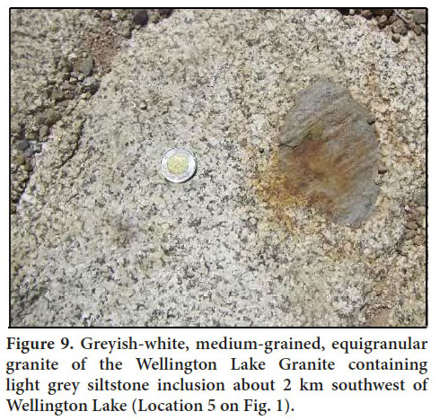
13 Distinctive, medium- to coarse-grained, light greyish-white to greyish-pink granite, underlying an area of about 15 km2 centered on Wellington Lake, was recognized during the recent mapping on west side of the New River about 19 km northeast of Lake Utopia (Fig. 1). Originally included as part of the Utopia Granite by McLeod (1990), its zirconiumrich geochemistry suggests that it may be a separate pluton (see geochemistry section below) and is herein referred to as the Wellington Lake Granite. It is bordered to the southeast by a narrow band of Mount Douglas Granite consisting of light pink, medium-grained granite grading into a finegrained porphyry containing rapakivi-mantled potassium feldspar. The Wellington Lake Granite is separated from the main mass of the Mount Douglas Granite to the northwest by a screen from 200 to 400 m wide of light grey siltstone with locally interbedded basalt assigned to the Silurian (Llandoverian to Wenlockian) Jones Creek Formation of the Mascarene Group (Fig. 2). Siltstone inclusions from 10 to 20 cm in diameter are common in the Wellington Lake Granite to the west of Wellington Lake near the unexposed northwestern contact with the sedimentary screen (Fig. 9). Sample 15-72 was collected at this site (Location 5 on Figs. 1 and 2) to define the age of crystallization of the Wellington Lake Granite.
 Display large image of Figure 9
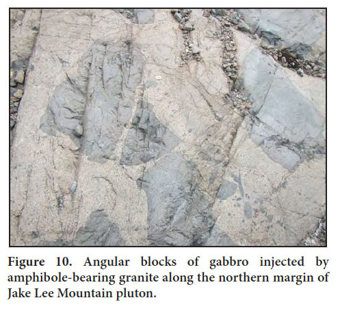
14 The peralkaline Jake Lee Granite, named by Currie (1988), is an oblong pluton about 20 km2 in area intruded into volcanic and sedimentary rocks of the Llandoverian Letete Formation (Mascarene Group) in the southeast, Pridolian sedimentary rocks of the Eastport Formation (Mascarene Group) in the northeast, and granitic rocks of the Utopia pluton in the northwest (Fig. 2). Its core consists of medium-grained, beige, equigranular, riebeckite-bearing granite grading outward to a fine-grained, light grey to light pink, porphyritic margin locally exhibiting rapakivi texture (Fyffe 1998). The fine-grained, northern margin of the Jake Lee Mountain pluton contains abundant, angular blocks of gabbro (Fig. 10). A coherent screen of gabbroic rocks about 300 m wide separates it from the Utopia Granite to the north. Sample JL16-1 was collected from medium-grained, beige granite forming the core of the Jake Lee Mountain pluton in order to determine the age of this previously undated peralkaline granite (Location 4 on Figs. 1 and 2).
 Display large image of Figure 10
LASER ABLATION ICP-MS U-Pb GEOCHRONOLOGY
15 U-Pb crystallization ages of zircon and monazite were determined by in situ laser ablation inductively coupled plasma-mass spectrometry (LA ICP-MS) at the University of New Brunswick. Standard polished thin sections were prepared and the zircon and monazite were analyzed using a Resonetics S-155-LR 193 nm ArF Excimer laser ablation (LA) system coupled to an Agilent 7700x quadrupole inductively coupled plasma-mass spectrometer (ICPMS). Only those zircon and monazite grains large enough to accommodate a 25 µm and 17µm diameter crater, respectively are measurable using laser ablation. Masses of 31P, 89Y, 202Hg, 204Pb, 206Pb, 207Pb, and 208Pb, 232Th, and 238U were analyzed with 31P used as a guide mass and for internal standardization (assuming ~13 wt. % P in monazite) for calculating Y, Pb, Th, and U concentrations in monazite. 90Zr was used as a guide mass and internal standardization (assuming ~43 wt. % Zr in zircon) for calculating Pb, Th, and U concentrations in zircon. For monazite, U-Pb isotope data was standardized using GSC-8153 monazite and the accuracy of the results confirmed using 44069 monazite (Aleinikoff et al. 2006). Zircon was standardized against 1099 Ma FC-1 zircon (Paces and Miller 1993) and accuracy checked using 337 Ma Plesovice zircon (Slama et al. 2008). Concentrations of U and Th in zircon were calculated relative to NIST610 which was analyzed throughout the analytical sequence. The data have been reduced using the VizualAge U-Pb geochronology data reduction scheme under Iolite software v. 2.5. Common-Pb correction was applied using Andersen (2002) method. A total between 45 and 82 of zircon and monazite analyses were obtained for each sample; however, of this total number of analyses a subset that are <5% discordant was used to calculate concordia ages using Isoplot version 3.71.09.05.23nx (Ludwig 2009). Details of the method have been described in McFarlane (2015) and Azadbakht et al. (2016). The results of the U-Pb monazite and zircon geochronological studies on the six samples selected for LA ICP-MS analysis (Table 1, Fig. 11) are discussed in detail below.
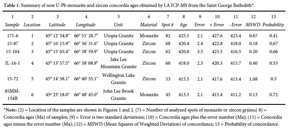 Display large image of Table 1*Note: (2) = Location of the samples are shown in Figures 1 and 2. (7) = Number of analyzed spots of monazite or zircon grains;( 8) = Concordia ages (Ma) of samples; (9) = Error is two standard deviations; (10) = Concordia ages plus the error number (Ma); (11) = Concordia ages minus the error number (Ma); (12) = MSWD (Mean Squares of Weighted Deviation) of concordance; 13 = Probability of concordance.
 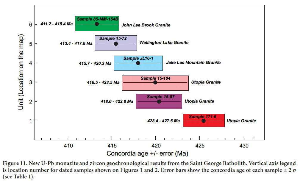 Display large image of Figure 11
Utopia Granite (sample 171-6)
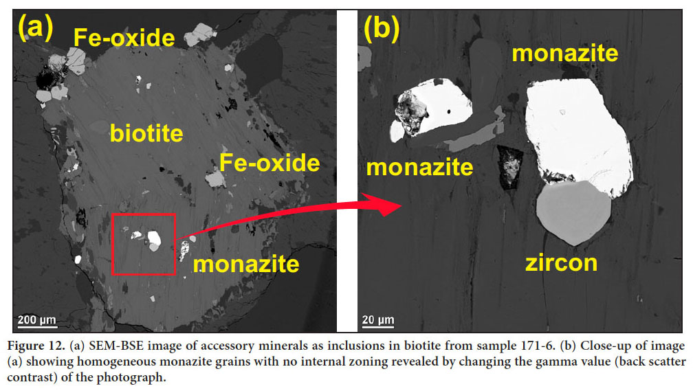
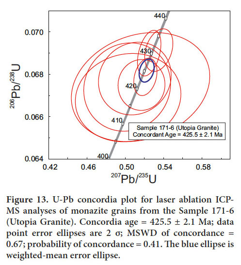
16 Sample 171-6 was collected on the summit of Dawson Mountain at Location 1 on Fig. 1. This light pink variety of Utopia Granite is a medium-grained, moderately altered granite with a slightly seriate texture composed of subhedral potassium feldspar, quartz, plagioclase, and biotite. Fractures and thin veins in the granite are filled with crystalline quartz. The perthitic potassium feldspar occurs as subhedral to euhedral twinned crystals up to 1.25 cm in diameter. Plagioclase occurs as smaller laths and is moderately altered to sericite in the central parts of grains. Quartz crystals are typically rounded and have seriate boundaries with the surrounding groundmass. Biotite grains are present as tabular grains rich in opaques (Fe-Ti oxides), zircon, monazite, and apatite. Monazite crystals occur as subhedral to anhedral and almost rounded grains ranging from very small up to 100 µm in diameter and are mostly in contact with other accessory minerals, such as Fe-Ti oxides, zircon, and apatite (Fig. 12). A total of 82 spot analyses on monazite grains were obtained for the U–Pb geochronological study (Table A1). The results for monazite grains from the Dawson Mountain sample yielded a U-Pb crystallization age of 425.5 ± 2.1 Ma (Table 1 and Fig. 13), i.e., Ludlovian according to the time scale of Ogg et al. (2016). This age is the same within error as the previously published U-Pb zircon age of 428.3 ± 1.0 Ma (latest Wenlockian) obtained on a sample of the typically red Utopia Granite exposed on Rte. 785 near the northern end of Lake Utopia (Barr et al. 2010).
 Display large image of Figure 12
 Display large image of Figure 13
Utopia Granite (samples 15-87 and 15-104)
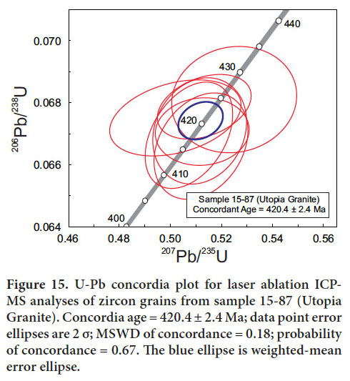
17 Sample 15-87 was collected on the east side of New River at Location 2 on Figs. 1 and 2. Previously included as part of Mount Douglas Granite (McLeod 1990), recent field observations indicate that it is textually more similar to the Utopia Granite in that rapakivi-mantling is lacking. The sample is a granular, medium-grained, pink granite composed mainly of quartz grains; perthitic potassium feldspar grains up to 0.75 cm in diameter, which are moderately altered to very fine-grained sericite along fractures or twinning planes; plagioclase grains that range from small inclusions hosted by potassium feldspar to moderately large subhedral-euhedral grains with a maximum diameter of 0.5 cm are locally altered to sericite along albite twin planes; and iron-rich biotite laths, which are altered to chlorite along cleavage planes. Zircon and apatite are the most abundant accessory minerals, mostly occurring as inclusions in biotite (Fig. 14a). The zircon crystals occur as subhedral to euhedral grains up to 100 µm in diameter that mostly are in contact with other accessory minerals, such as Fe-Ti oxides, apatite, and xenotime, and exhibit oscillatory zoning (Fig. 14b). Only those zircon crystals large enough to accommodate a 25 µm- diameter crater are measurable using laser ablation, and inclusionand crack-free grains are preferred for analyses. A total of 68 spot analyses of zircon grains were ablated for the U-Pb geochronological study (Table A2). The results for zircon grains from sample 15-87 yielded a U-Pb crystallization age of 420.4 ± 2.4 Ma (Table 1 and Fig. 15), confirming that it is of Silurian (Pridolian) age and, therefore, part of the Utopia pluton rather than the Late Devonian Mount Douglas pluton.
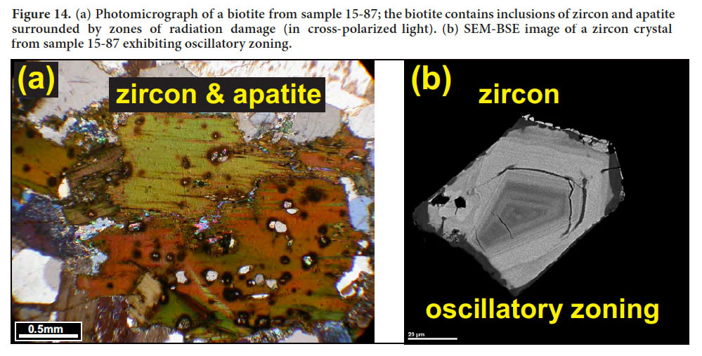 Display large image of Figure 14
 Display large image of Figure 15
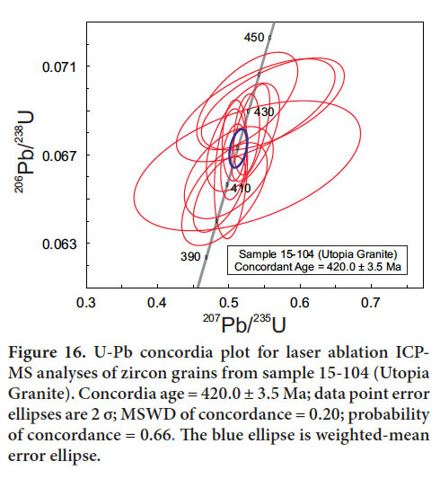
18 A sample of medium-grained, pink, biotite granite (sample 15-104) was collected on the west side of New River at Location 3 on Figs. 1 and 2 to confirm that the Utopia Granite extends into the area south of Wellington Lake. The exposures in this area were previously included as part of Jake Lee Mountain Granite (McLeod et al. 1998) but recent field observations indicate that amphibole is not present in these rocks. A total of 62 spot analyses of zircon grains were ablated for the U–Pb geochronological study (Table A3). The analytical results on the zircon grains from sample 15-104 yielded a U-Pb crystallization age of 420.0 ± 3.5 Ma (Table 1 and Fig. 16) essentially identical to that obtained from sample 15-87.
 Display large image of Figure 16
Jake Lee Mountain Granite (sample JL16-1)
19 A sample of medium-grained, beige, equigranular, riebeckite-bearing granite (sample JL16-1) was collected along the resource road leading west off the Anthony Lake Road toward Jake Lee Mountain at Location 4 on Figs. 1 and 2. The sample is composed of quartz up to 2 mm in diameter, slightly altered perthitic potassium feldspar grains up to 3 mm in diameter, minor plagioclase with a maximum diameter of 1 mm; and iron-rich biotite laths, which are intensely altered to Fe-Ti oxides. Quartz and alkali feldspar are locally intergrown in a granophyric texture within a mosaic of polygonal, equigranular crystals of quartz and alkali feldspar. Accessory minerals include euhedral to subhedral zircon crystals that display oscillatory zoning, Fe-Ti oxides, and monazite crystals, which are present as inclusions in zircon or as small grains near or in contact with zircon and Fe-Ti oxide grains. Fine fractures and quartz stringers are present in the specimen.
20 A total of 60 spot analyses of zircon grains were ablated for the U-Pb geochronological study (Table A4). The analytical results from zircon grains from sample JL16-1 yielded a U-Pb crystallization age of 418.0 ± 2.3 Ma for the core of the Jake Lee Mountain Granite (Table 1 and Fig. 17). Although this latest Pridolian to earliest Lochkovian age overlaps statistically with the ages obtained from the two samples of Utopia Granite in the New River area, it is consistent with the Jake Lee Mountain Granite being the younger pluton based on the presence of its finer grained northern margin (Fyffe 1998; Barr et al. 2010). The peralkaline Welsford Granite, dated at 422 ± 1 Ma (Bevier 1990), is not found in contact with the Utopia Granite whereas the undated peralkaline Parks Brook Granite is veined by the Utopia Granite.
 Display large image of Figure 17
Wellington Lake Granite (sample 15-72)
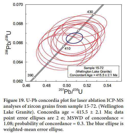
21 Sample 15-72 from the Wellington Lake Granite was collected at Location 5 on Fig. 1 and 2 along a resource road running south off the Anthony Lake Road to the west of Wellington Lake. This sample is a holocrystalline, greyish pink, medium-grained, equigranular granite dominated by quartz; perthitic potassium feldspar grains, which are moderately altered to sericite; plagioclase grains, which are altered to sericite in their central parts (Fig. 18a); and biotite laths. Accessory minerals are subhedral zircon (Fig. 18b), apatite, monazite, and xenotime, which are mostly hosted by biotite; and garnet, which occurs as inclusions in plagioclase. A total of 53 spot analyses of zircon grains were ablated for the U–Pb geochronological study. The analytical results on the zircon grains from sample 15-72 (Table A5) yielded a U-Pb crystallization age of 415.5 ± 2.1 Ma (Table 1 and Fig. 19). This Early Devonian (Lochkovian) age together with its unique textural characteristics (Fig. 9) and chemical composition (see below) supports the recognition of the Wellington Lake Granite as distinct from the Silurian Utopia Granite, to which it was previously assigned (McLeod 1990).
 Display large image of Figure 18
 Display large image of Figure 19
John Lee Brook Granite (sample 85MM-154B)
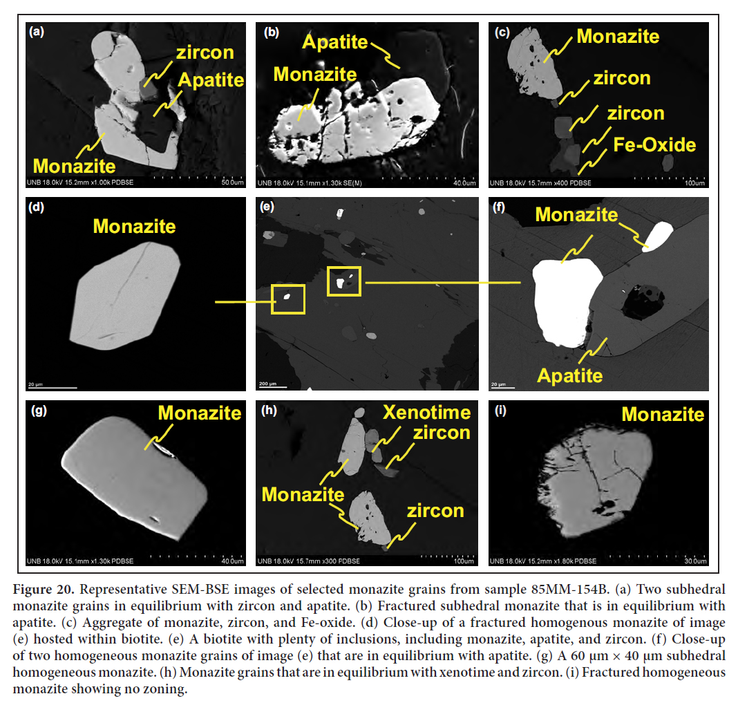
22 Sample 85MM-154B from the John Lee Brook Granite was collected by Malcolm McLeod in 1985 during his mapping of the Saint George Batholith (McLeod 1990). The sample site at Location 6 on Figs. 1 and 2 is located along a resource road about 3 km west of Rte. 785 near the headwaters of John Lee Brook. This white, medium-grained, equigranular, twomica granite exhibits hypidiomorphic granular texture and is composed mainly of quartz, moderately altered perthitic potassium feldspar and plagioclase, and biotite (up to 20%), which is partially altered to chlorite. About 5 % primary muscovite is present but no garnet was observed. Zircon, monazite, apatite, xenotime, and Fe-Ti oxides are accessory minerals.
23 Scanning electron microscope-back scattered electron (SEM-BSE) images of monazite-bearing specimens from the John Lee Brook Granite were taken using software application dPict32 (developed by Geller Microanalytical Laboratories). The abundant accessory monazite in the sample of John Lee Brook Granite occur primarily as inclusions in principal minerals, such as biotite, or in contact with other accessory minerals. To obtain a reliable age of emplacement, monazite grains showing evidence that they were crystallized from a magma and not exhibiting inherited cores need to be chosen for measurement. Thus, monazite grains that are in equilibrium with other accessory minerals, such as apatite and xenotime, were selected for geochronological studies (Figs. 20 a, b, f, and h); disseminated monazite grains hosted as inclusions in biotite appear to be relatively homogeneous and reveal no inherited cores (Figs. 20c–d).
 Display large image of Figure 20
24 The monazite occurs as subhedral grains from 5 to 80 µm in diameter. Only those grains large enough to accommodate a 17 µm diameter crater are measurable using laser ablation. Chemical discriminants, such as Y vs. U/Th, and P vs. U/Th, indicate that the monazite is chemically homogeneous, although faint patchy zoning was locally evident in SEM-BSE images (Figs. 20b, g).
25 A total of 45 spot analyses of monazite grains were ablated for the U-Pb geochronological study (Table A6). The analytical results on the monazite grains from the John Lee Brook Granite yielded a crystallization age of 413.3 ± 2.1 Ma (Table 1 and Fig. 21). This Early Devonian (Lochkovian) age is significantly older than the previous age of 384 ± 7 Ma obtained by 40Ar/39Ar dating of muscovite (McLeod 1990). The contact between the John Lee Brook pluton and adjacent Magaguadavic pluton is located about 2 km south of the sample site at Location 6. This site yielded both the monazite age and younger muscovite age for the John Lee Brook Granite so it is likely that the intrusion of the Magaguadavic Granite was responsible for resetting the 40Ar/39Ar isotopic system in the muscovite.
 Display large image of Figure 21
26 By way of contrast, ages obtained by various geochronological methods from the Magaguadavic Granite in the McDougall Lake area all fall within a relatively narrow range indicating its isotopic systems were not significantly affected by later intrusive events. A sample of megacrystic granite along Rte. 785 just east of McDougall Lake yielded a U-Pb zircon age of 396 ± 1 Ma (Bevier 1990) and an 40Ar/39Ar biotite age of 400 ± 4 Ma (McLeod 1990). A porphyritic granitic dyke along the northwestern margin of the Magaguadavic Granite at the Clarence Stream gold deposit (CS on Fig. 1) yielded a U-Pb monazite age of 395.5 ± 0.5 Ma, and a pegmatitic dyke in the same area yielded a U-Pb monazite age of 390 ± 8 Ma and a U-Pb zircon age 400 ± 5 Ma (Thorne et al. 2002, 2008; Davis et al. 2004).
GEOCHEMISTRY
27 Dated samples from the Utopia Granite (Sample 171-6 and 15-87) and Wellington Lake Granite (Sample 15- 72) were analyzed for major elements and selected trace elements, including rare earth elements (REEs). The method used was laser ablation inductively coupled plasma-mass spectrometry (LA ICP-MS) on fused glass beads at the University of New Brunswick. Standards BCR-2, GSP-2, and SY-4 were used to check precision and accuracy on the fusion beads. Major elements were obtained with a JEOL JSM 6400 Scanning Electron Microscope equipped with an EDAX Genesis X-ray microanalysis system (SEM-EDS). The accelerating voltage was 15 kV and the probe current was approximately 1.5 nA. Spectra were collected for 50 s live-time. Trace element analyses were performed using LA-ICP-MS with a 45µm diameter crater. Standards used were NIST-610 (primary concentration standard), NIST-612 (secondary concentration standard), and BCR-2G (QC standard). The geochemical results are shown in Table 2 together with data on the John Lee Brook Granite (sample 85MM-154B) taken from McLeod (1990). No analysis is available for the dated Jake Lee Mountain Granite (sample J16-1).
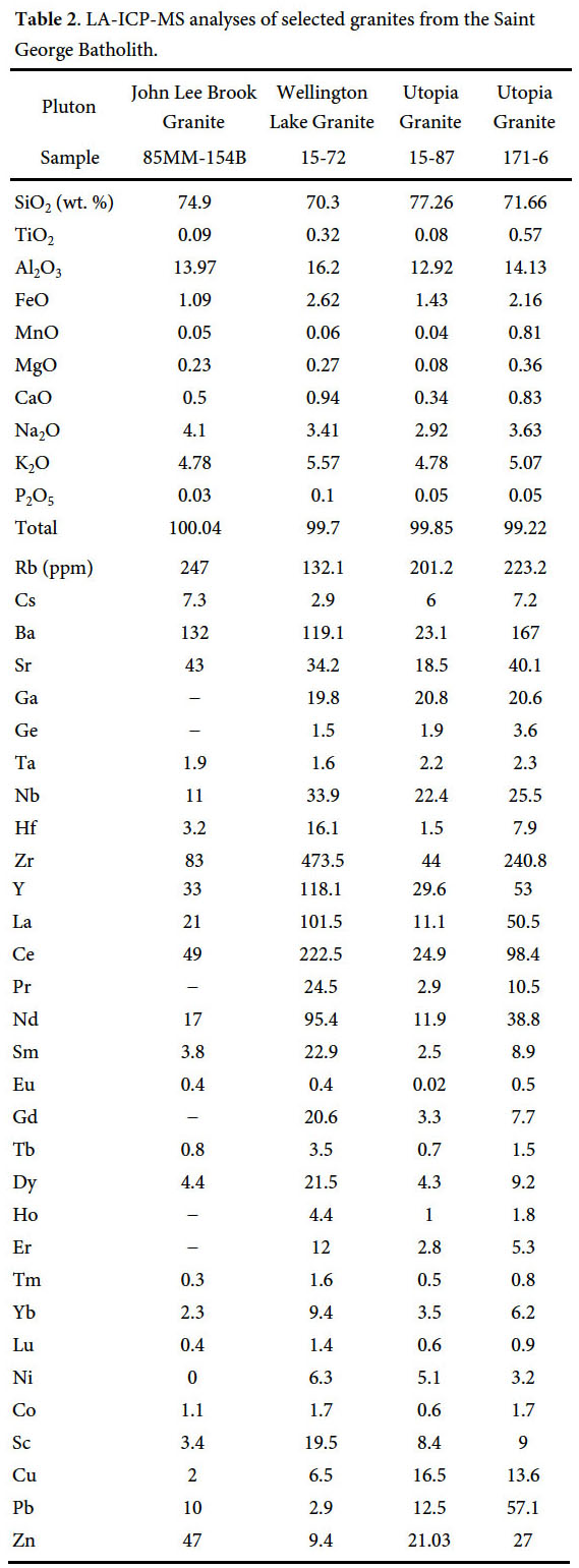 Display large image of Table 2
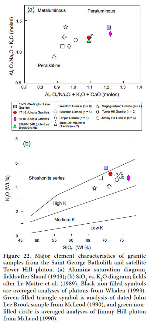
Major element characteristics
28 Sample 15-72 from the Wellington Lake Granite has the lowest silica content (70.3 wt.%) followed by sample 171-6 from the less evolved Utopia Granite (71.7 wt. %), sample 85MM-154B from the John Lee Brook Granite (74.9 wt.%), and sample 15-87 from the more evolved Utopia Granite (77.3 wt.%). All four of the dated samples fall in the peraluminous field (Fig. 22a) and are characterized by high (Fe2O3 + FeO)/MgO ratio (ranging from 4.7 to 17.9), alkalis with K2O/Na2O >1, and low CaO, P2O5, TiO2, and MgO (Table 2). On the plot of SiO2 versus K2O (Fig. 22b), samples from the John Lee Brook and Utopia granites plot in the fields of high-K; whereas the sample from the Wellington Lake Granite is associated with the shoshonite series.
 Display large image of Figure 22
Trace and rare earth element characteristics
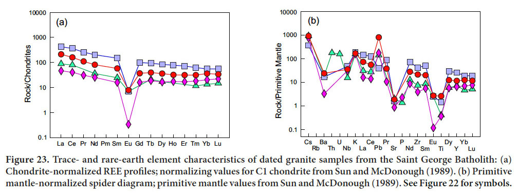
29 Geochemical data presented by McLeod (1990) and Whalen (1993) indicate that the granite dated on Dawson Mountain and that dated by Barr et al. (2010) on the northern end of Lake Utopia, both of which have yielded Ludlovian ages of emplacement, are less evolved than the granite dated as Pridolian to the east of New River (Sample 15-87). McLeod’s and Whalen’s data also indicate that granite similar in composition to that east of New River also exists in the southern part of the Lake Utopia area to the east of Lily Lake (Fig. 1), suggesting that the Utopia Granite is a composite pluton composed of an older less evolved component (ave. SiO2 = 73.6 wt.%, n = 6), and a younger more evolved component (ave. SiO2 = 76.8 wt.%, n = 4). A conspicuous magnetic lineament, located about 1 km north of Lily Lake, trends eastward to Lake Utopia and may represent the boundary between these two components in the western part of the Utopia pluton.
30 Differences between spider diagrams of the three plutons are highlighted by the contrasting REE patterns of each pluton (Fig. 23a). The REE profiles of the Utopia and Wellington Lake samples are relatively flat with gentle negative slopes. The highly evolved Utopia Granite from east of New River (sample 15-87) has the largest negative Eu anomaly (Eu/Eu* = 0.02), the lowest normalized light (LREE) to heavy (HREE) rare earth ratio [(La/Yb)N = 2.3], and most pronounced negative Ba, Sr, and Ti anomalies (Fig. 23b). Sample 15-87 also has lower overall REE abundances reflecting possible fractionation of zircon/xenotime, and monazite/apatite, which have high partition coefficients for HREE and LREE, respectively, and are abundant in this sample. The relatively high negative slope of sample 85MM-154B [(La/Yb)N = 6.5] from the John Lee Brook Granite (Fig. 23a) is possibly the result of the presence of refractory garnet in the source area or of late-stage fractionation of garnet, which has a high partition coefficient for HREE and is abundant as inclusions mostly hosted by plagioclase in this sample. The prominent negative Nb and Ti anomalies exhibited by the John Lee Granite on the HFSE/primitive mantle spider diagram (Fig. 23b) are likely an inherited signature derived from melting of old granitic basement or arc-derived clastic sedimentary rocks in the source region at 413 Ma.
 Display large image of Figure 23
31 Sample 15-72 from the Wellington Lake Granite contains the highest overall REE abundances, exhibits the highest normalized LREE enriched pattern [(La/Yb)N = 7.73] that is accompanied by a relatively small negative Eu anomalies (Eu/Eu* = 0.06), likely reflecting fractionation in a more oxidized magmatic system where more of the Eu is present as Eu+3 and hence would not be incorporated into the crystallizing plagioclase (e.g., Sisson and Grove 1993).
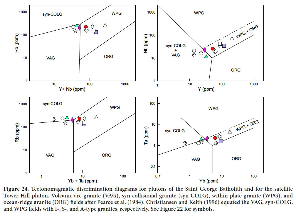
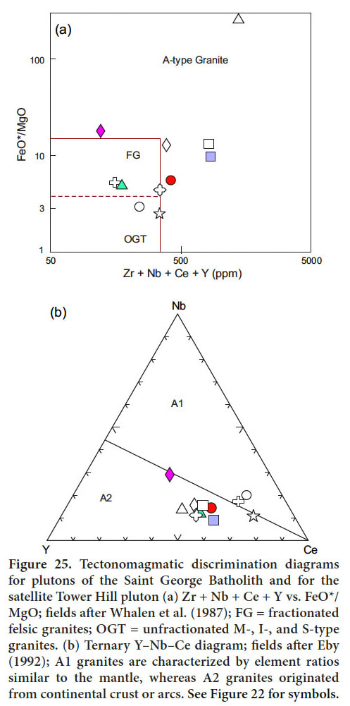
32 On ‘Rb vs Y + Nb’, ‘Rb vs Yb + Ta’, ‘Nb vs Y’, and ‘Ta vs Yb’ tectonomagmatic discrimination diagrams (Fig. 24), the dated samples from the Utopia and Wellington Lake granites plot in the within-plate, ‘A-type’ field whereas the John Lee Brook Granite falls mainly within the syn-collisional, ‘S-type’ field. On the FeO* vs Zr + Nb + Ce + Y discrimination diagram, the Utopia and Wellington Lake samples again fall in the ‘A-type’ field (Fig. 25a), whereas the John Lee Brook sample plots in the fractionated granite field (FG). On the ternary Y-Nb-Ce discrimination diagram (Fig. 25b), the dated samples all fall in the crustal ‘A-type’ field, although the strongly fractionated Utopia Granite sample from east of New River plots toward a ‘mantle-type’ granite.
 Display large image of Figure 24
 Display large image of Figure 25
TECTONIC EVOLUTION OF THE MASCARENE BACKARC BASIN
33 The current plate tectonic model developed for the post-Penobscottian evolution of southern New Brunswick relates Acadian (late Silurian to early Devonian) tectonism in the region to closure of a remnant oceanic tract, referred to as the Acadian Seaway (van Staal et al. 1996; Fyffe et al. 1999; Barr et al. 2002; White et al. 2006; van Staal et al. 2009). This seaway separated the peri-Gondwanan microcontinent of Avalonia (see inset on Fig. 1) from the amalgamated terranes already accreted to the Laurentian continental margin during Early Paleozoic closure of the Iapetus Ocean. The peri-Gondwanan microcontinent of Ganderia, the most outboard of these Iapetan terranes, was accreted to the Laurentian margin during Salinic (late Ordovician to late Silurian) orogenesis. Precambrian rocks of the New River and Brookville belts are considered to underlie the sparsely preserved platform of Ganderia, whereas the Cambrian-Ordovician sedimentary rocks of the St. Croix belt are interpreted to represent its Paleozoic passive margin (van Staal et al. 1996; Fyffe et al. 2011). Subsequent Acadian tectonism and magmatism in southwestern New Brunswick is attributable to accretionary events associated with closure of the Acadian Seaway by northwest-directed subduction beneath the Kingston arc-Mascarene backarc system and its St. Croix-New River substrate (Fig. 1). The arc-backarc system was subsequently extensively dismembered by strike-slip displacement along the Sawyer Brook, St. George, Wheaton Brook, Belleisle, and Kennebecasis faults (Stewart et al. 1995; Fyffe et al. 1999, Fyffe et al. 2011). The Sawyer Brook, St. George, and Wheaton Brook faults were inactive by the Late Devonian as they are cross-cut by the Mount Douglas Granite, emplaced between 367 ± 1 and 366 ± 1 Ma (Bevier 1989; McLeod 1990).
34 The Mascarene backarc basin is situated along the transitional zone between the Ganderian platform comprised of Neoproterozoic basement rocks and its thin cover of Cambrian quartzite (New River belt) in the south and the Ganderian passive margin comprised of a thick succession of Cambrian-Ordovician sedimentary rocks (St. Croix belt) in the north (Fyffe et al. 2011). The Silurian sequences in the dismembered backarc basin, which are all included in the Mascarene Group, have been divided into several formations (i.e., Oak Bay, Waweig, Letete, Long Reach, Jones Creek, and Eastport), described briefly below. The contact between the steeply dipping conglomerate of the Silurian Oak Bay Formation at the base of the Mascarene Group and Cambrian-Ordovician sedimentary rocks of the Cookson Group is generally marked by the Sawyer Brook Fault, along which considerable transcurrent movement has occurred (Park et al. 2008).
35 Volcanic rocks become abundant up-section in the Oak Bay Formation and the contact with the overlying Waweig Formation, a sequence of moderately dipping, light pink, fossiliferous, fine-grained sandstone and siltstone interbedded with felsic and lesser mafic tuffs, is gradational (Fyffe et al. 1999). A felsic tuff in the Waweig Formation yielded an early Silurian (Llandoverian) U-Pb zircon date of 438 ± 4 Ma (Miller and Fyffe 2002). The Letete Formation, a complexly deformed, steeply dipping sequence of felsic and mafic tuffs interbedded with dark grey shale, lies along the southern margin of the Mascarene backarc basin between the St. George and Wheaton Brook faults (Fig. 1). Felsic tuff from the Letete Formation yielded an early Silurian (Llandoverian) U-Pb zircon date of 437 ± 7 Ma (Miller and Fyffe 2002). Mascarene strata to the east of the Saint George Batholith (Fig. 1) include mafic flows and tuffs of the Long Reach Formation and conformably overlying, fine-grained, feldspathic sandstone, siltstone, dacitic flows, and minor mafic tuffs of the Jones Creek Formation. Brachiopods indicate a late Llandoverian to early Wenlockian age for the Long Reach Formation (McCutcheon and Ruitenberg 1987), and associated dacitic volcanic rocks have yielded an early Silurian (early Wenlockian) U-Pb zircon date of 432 ± 2 Ma (N. Van Wagoner, written communication to M. McLeod, 2001). An equivalent sequence of volcanic rocks lying beneath the late Silurian Eastport Formation in adjacent Maine has suprasubduction-zone geochemical signatures (Llamas and Hepburn 2013).
36 The early Silurian volcanic sequences of the Oak Bay, Waweig, Long Reach, Jones Creek, and Letete formations, which are at least partially coeval with the volcanic arc rocks in the Kingston Group, are considered here to have been generated in a continental backarc basin in an extensional suprasubduction-zone environment (Fyffe et al. 1999; Barr et al. 2002; White et al. 2006; van Staal et al. 2009). Fossil and geochronological data are consistent with a period of uplift and erosion or non-deposition of Silurian strata in the Mascarene backarc basin in the mid- to Wenlockian. This hiatus, delineated radiometrically by the age of the youngest suprasubduction-zone related volcanism (432 ± 2 Ma) and oldest non-arc plutonism (428 ± 1 Ma) constrains the timing of the closure of the Acadian Seaway and collision of Avalonia with the Ganderian margin of composite Laurentia to the mid-Silurian.
37 The mid-Silurian hiatus in the Mascarene backarc basin was followed by deposition of the shallow-marine to subaerial succession correlated with the Eastport Formation in Maine (Fyffe et al. 1999). The Eastport Formation in New Brunswick, which occurs along the southern margin of the Saint George Batholith to the north of the St. George Fault (Fig. 1), comprises a gently southerly dipping succession of mafic and felsic flows and tuffs interbedded with peritidal to subaerial, red sandstone and siltstone. Felsic flows in the middle section of the Eastport Formation are enriched in Zr (Van Wagoner et al. 2002), suggesting that they may be the extrusive equivalents of the peralkaline Welsford, Jake Lee Mountain, and Parks Brook granites. The Eastport volcanic rocks have within-plate geochemical signatures and have been reported to have a late Ludlovian to early Pridolian age based on the poorly documented, preliminary U-Pb zircon date of 423 ± 1 Ma (Van Wagoner et al. 2002). The location of the dated felsic flow is not known with certainty but it was likely collected about 1 km above the base of the Eastport Formation.
LATE SILURIAN – EARLY DEVONIAN PLUTONISM
38 The bulk composition, spatial distribution, and timing of emplacement of the various Silurian (late Wenlockian to Pridolian) to Early Devonian (Lochkovian to Emsian) plutonic rocks in southwestern New Brunswick are discussed below in relationship to the tectonomagmatic evolution of the Kingston arc-Mascarene backarc system (Kingston and Mascarene belts on Fig. 1). As emphasized by Hyndman et al. (2005), convective heat flow in backarc regions can continue for some tens of millions of years after subduction stops; these hot and weak former backarcs can then become the focus of high temperature metamorphism, ductile deformation, and plutonism. Based on previously published geochronological data, the composite Saint George Batholith was emplaced into the Mascarene backarc basin during three separate intervals (428 to 422 Ma; 403 to 390 Ma; and 367 to 366 Ma), covering a time span of approximately 60 million years (Bevier 1989, 1990; McLeod 1990; Whalen et al. 1996; Thorne et al. 2002, 2008; Davis et al. 2004; Barr et al. 2010). The new results reported above indicate magmatic activity also occurred in the backarc between 418 and 413 Ma (Table 1) and indicate that the tectonomagmatic history of the Saint George Batholith was more protracted than previously envisioned. All these intrusive episodes took place after the eruption of suprasubduction – zone related volcanism in the Mascarene backarc basin had ceased at 432 ± 2 Ma.
Silurian (late Wenlockian to Pridolian) magmatism
39 The Silurian (late Wenlockian to Pridolian) ‘A-type’ granite plutons that were emplaced along the southern margin of the Mascarene backarc basin (Welsford, Jake Lee Mountain, Parks Brook, Utopia granites, and felsic components of the Bocabec Gabbro) generally show little evidence of deformation compared to the minor intrusions described below along the northern margin of the basin. Emplacement of the southern Silurian plutons overlapped with the eruption of bimodal flows and tuffs of the Eastport Formation dated at 423 ± 1 Ma (Van Wagoner et al. 2002). The Welsford and Utopia granites have been previously dated by U-Pb on zircon at 422 ± 1 and 428.3 ± 1.0 Ma, respectively (Bevier 1990; Barr et al. 2010). The new results reported here include a U-Pb date on monazite of 425.5 ± 2.1 Ma for the less evolved phase of the Utopia Granite, U-Pb dates on zircon of 420.4 ± 2.4 and 420.0 ± 3.5 Ma for the more evolved phase of the Utopia Granite, and a U-Pb on zircon of 418.0 ± 2.3 Ma for the Jake Lee Mountain Granite, which straddles the Pridolian-Lochkovian boundary (Fig. 11; Table 1). The undated Parks Brook peralkaline granite must be older than 420 Ma as it is veined by the Utopia Granite.
40 The elongated shapes of these high-level ‘A-type’ plutons suggest that their emplacement was at least partly controlled by high heat flow along pre-existing, extensional fault-structures in the basement rocks defining the ‘active’ southeastern boundary of the Mascarene backarc basin (Fig. 1). Only the Jake Lee Mountain pluton displays evidence of significant shearing, likely attributable to late-stage movement on the St. George Fault (Figs. 1 and 2). More significant fault displacement along the southern margin of the backarc basin appears to have been taken up largely within the highly strained strata of the Letete Formation, located farther to the south between the St. George and Wheaton Brook faults (Fyffe et al. 1999).
41 The peralkaline, amphibole-bearing Welsford and Jake Lee Mountain granites, and biotite-bearing, Utopia Granite are classified as ‘A-type’ granites (Whalen 1986; Whalen et al. 1987). The generation of the peralkaline plutons may have involved partial melting of subcontinental lithospheric mantle (Whalen et al. 2006), whereas the generation of the contemporaneous ‘aluminous A-type’ Utopia Granite likely involved partial melting of dehydrated, granulite-facies, lower continental crust (King et al. 1997). Underplating of the lithosphere with mantle-derived mafic magma is required to produce the high temperatures required to melt the relatively anhydrous protoliths of ‘A-type’ granites. Neodymium epsilon values [εNd (430 Ma)] of + 2.7 for granite from the Bocabec Gabbro, + 2.3 from the Utopia biotite granite, and + 3.4 from the Welsford peralkaline granite indicate some mixing of mantle-derived mafic magma with the partial melts (Whalen et al. 1994; Whalen et al. 2006).
42 The Sawyer Brook Fault acted as a brittle, normal fault along the northern margin of the Mascarene backarc basin during deposition of the early Silurian Oak Bay conglomerate (Stringer and Burke 1985; Fyffe et al. 1999). Subsequently, a series of mafic dykes were emplaced into this margin of the backarc basin, along a probable splay off the Sawyer Brook Fault. The dykes, each about 30 m in width, occupy a 300 m-wide, northeast-trending dextral shear zone along the northwestern margin of the Magaguadavic pluton. As seen in gold exploration trenches in the Clarence Stream area (CS on Fig. 1), the dykes contain penetrative schistosity of aligned biotite and actinolite that is parallel to the trend of the dykes and cross-cuts an earlier phyllitic cleavage in the Silurian volcanic and sedimentary host rocks of the Waweig Formation; locally the dykes are highly boudinaged. The late schistosity in the sedimentary rocks, defined by muscovite and biotite, wraps around cordierite porphyroblasts, which contain relicts of the earlier phyllitic cleavage (Thorne and Lentz 2001; Park et al. 2008; Thorne et al. 2008). The mafic dykes in the Clarence Stream shear zone are petrochemically similar to, and may represent offshoots from, the Bocabec Gabbro. If this correlation is correct, the dykes were emplaced in the later part of the Silurian (Ludlovian to Pridolian) at about 422.1 ± 1.3 Ma (Clarke et al. 2017).
43 High-strain shear zones have also been mapped in the St. Croix and Fredericton belts to the northwest of the Sawyer Brook Fault. The Mohannes Granite, located about 10 km to the west of the area shown in Fig. 1, is light grey, granodiorite to monzogranite that was emplaced into Cambrian-Ordovician sedimentary rocks along the northern margin of the St. Croix belt (Fyffe et al. 1991). This oblong, relatively small, ‘I-type’ pluton, which yielded a preliminary U-Pb emplacement age on zircon of 420 ± 5 Ma (Fyffe and Bevier 1992), contains a penetrative, northeast-trending, cataclastic fabric defined by aligned augen of plagioclase and potassium feldspar set in a granulated quartz matrix. Like in the contact aureole of the mafic dykes in the Clarence Stream area, cordierite porphyroblasts in the host rocks of the Mohannes Granite show evidence of growth during deformation.
Early Devonian (Lochkovian to Emsian) magmatism
44 The John Lee Brook, Jimmy Hill, and Magaguadavic granites, which form the northwestern part of the Saint George Batholith (Fig. 1), are all Early Devonian in age. Both the John Lee Brook and Jimmy Hill plutons appear to be entirely confined to the St. Croix and Fredericton belts on the north side of the Sawyer Brook Fault. The new LA ICP-MS in situ U-Pb age of 413.3 ± 2.1 Ma indicates that the John Lee Brook Granite was emplaced during the Lochkovian stage (Ogg et al. 2016). Also, the U-Pb zircon crystallization ages of 415.5 ± 2.1 Ma obtained from the newly recognized Wellington Lake Granite indicates that some high-field-strength-element-enriched magmatic activity was taking place within the Mascarene backarc basin along the southern margin of the Saint George Batholith in early Lochkovian time.
45 The John Lee Brook pluton has an elongated shape but does not display a fabric, suggesting that its emplacement took place during the waning stages of transpressional tectonic activity. In marked contrast, the Magaguadavic pluton is roughly circular in outline indicating that its emplacement post-dated major fault movement. Like the Tower Hill Granite, which lies entirely in the St. Croix belt, the two-mica John Lee Brook Granite is peraluminous with a high Aluminum Saturation Index (ave. ASI of 1.08) and low εNd (400 Ma) value of + 0.3 compared to the other plutons comprising the Saint George Batholith (Whalen et al. 1996). It thus has properties transitional to ‘S-type’ granites and was likely derived in part by melting or assimilation of supracrustal metasedimentary rocks (Chappell and White 1974). In contrast, the metaluminous megacrystic Magaguadavic Granite, with an ASI of 0.9 and εNd (400 Ma) of + 2.0, has ‘I-type’ characteristics and its generation can be attributed to partial melting of metaigneous rocks in the lower crust (Chappell and White 1974; Whalen et al. 1994, 1996; Yang et al. 2008); the presence of large potassium feldspar phenocrysts indicates that the magma may have been sequestered in the deep crust for some time before rising and solidifying nearer to the surface (McLeod 1990).
46 The Magaguadavic Granite was emplaced during the Emsian Stage of the Early Devonian as indicated by previously published U-Pb dates on zircon of 396 ± 1 Ma (Bevier 1989; Davis et al. 2004). Th e John Lee Brook and Magaguadavic granites differ markedly in texture, mineralogy, and chemistry, as well as in age. The John Lee Brook Granite generally contains biotite, muscovite, and garnet; and is high in silica (ave. SiO2 = 74.0 %). The Magaguadavic Granite contains megacrysts of potassium feldspar, and biotite and hornblende, and is low in silica (ave. SiO2 = 68.5 wt.%).
47 A m-wide granitic dyke in the Clarence Stream shear zone (CS on Fig. 1) has yielded a U-Pb (monazite age) of 395.5 ± 0.5 Ma (Davis et al. 2004). Its age and the presence of potassium-feldspar phenocrysts (1 to 2 cm in length) suggest that the granitic dyke is an offshoot of the nearby Magaguadavic pluton. However, unlike the main pluton, the dyke exhibits a weak tectonic fabric. It could be concluded from this that dextral shearing associated with the Sawyer Brook Fault may have taken place episodically over a period of at least 25 million years, i.e., between 421 Ma, the presumed age of intrusion of the sheared mafic dykes in the Clarence stream area, and 396 Ma, the age of the associated foliated granitic dyke (Thorne and Lentz 2001; Park et al. 2008; Thorne et al. 2008). Alternatively, the shearing in the granitic dyke may reflect local re-activation of the Sawyer Brook splay within the contact aureole of the Magaguadavic Granite.
48 The Tower Hill Granite, which transects the core of a late antiform in the St. Croix belt (Fig. 1), is undeformed, except where it is intersected by the northwest-trending Oak Bay Fault (Fyffe et al. 1991, 1999; Castonguay et al. 2003). It contains both biotite and muscovite, is highly peraluminous (ASI of 1.14), and has a negative εNd (400 Ma) value of - 0.4 (Whalen et al. 1996). A high temperature-low pressure metamorphic assemblage of biotite, andalusite, staurolite, garnet, muscovite, and quartz is developed in the sedimentary rocks up to 500 m from the granite (Ruitenberg 1967; Fyffe et al. 1991). A minimum age of emplacement for the Tower Hill Granite is given by an Rb-Sr muscovite isochron date of 401 ± 4 Ma (Whalen et al. 1996). An undeformed microgranite dyke, located approximately 2 km east of Tower Hill, yielded a U-Pb zircon age of 409 ± 2 Ma (Davis et al. 2004).
DISCUSSION AND CONCLUSIONS
49 Average bulk chemical compositions of plutons comprising the Saint George Batholith and satellite Tower Hill pluton have been calculated using published analyses from McLeod (1990) and Whalen (1993) to supplement the data reported herein for the newly dated samples. These averaged values confirm that the spatial and temporal variations observed from southeast to northwest across the batholith are reflected systematically in the trace-element, REE, and isotopic Nd geochemistry of the clustered plutons (Figs. 23 and 24). On the Pearce et al. (1984) discrimination diagrams, granitic samples from the Bocabec, Utopia, Welsford, Jake Lee Mountain, and Wellington Lake plutons all fall in the ‘within –plate’ ‘field whereas the John Lee Brook, Jimmy Hill, Magaguadavic, and Tower Hill plutons fall mainly on the boundary between the’ syn-collisional’ and ‘volcanic-arc’ fields (Fig. 24).
50 The geochemical variation across the Saint George Batholith can be explained in terms of the transition of the Kinston arc-Mascarene backarc system from an extensional arc to transpressional tectonic environment during the Acadian orogeny, which was caused by closure of the Acadian Seaway and collision of the Avalonian microcontinent with the composite Laurentian margin (van Staal et al. 2009). The initial extensional nature of the Kingston arc is indicated by the early Silurian emplacement of a high-level bimodal intrusive complex into the host volcanic-arc rocks of the Kingston Group. Mafic and granitic dykes in this complex have active-continentalmargin and within-plate signatures, respectively (Eby and Currie 1993). A subsequent change to a compressive environment is indicated by the presence of a zone of low temperature-high pressure metamorphism along the southeastern margin of the Kingston arc, which occurred after emplacement the late Llandoverian intrusive complex at 436 ± 2 Ma (Doig et al. 1990) and prior to 420 ± 2 Ma, the oldest 40Ar/39Ar cooling age of metamorphic amphibole defining the foliation in the mafic dykes (Nance and Dallmeyer 1993; Barr et al. 2002; White et al. 2006).
51 A much later, high temperature-intermediate pressure ‘regional contact’ metamorphic event associated with emplacement of the Tower Hill Granite at about 401 Ma is evident in the St. Croix belt to the northwest of the Mascarene backarc basin (Fyffe et al. 1991; Whalen et al. 1996). Staurolite and garnet are present in pelitic rocks of both the low-pressure metamorphic assemblage in the St. Croix belt and high-pressure assemblage in the Kingston belt but the garnets in the St. Croix assemblage are significantly lower in magnesium and higher in manganese content (Fyffe et al. 1991; White et al. 2006). The contrast between the penetrative deformation apparent in the Pridolian Mohannes Granite in the St. Croix belt, and the relatively undeformed nature of the late Wenlockian to Pridolian plutons of the Saint George Batholith on opposite sides of the Sawyer Brook Fault (Fig. 1), is likely a reflection of the depth of emplacement and subsequent uplift of the hotter, deeply buried, complexly deformed, Cambrian-Ordovician sedimentary sequence in the northwest, compared to the cooler, near-surface, gently dipping volcanic sequence (Eastport Formation) exposed along the southeastern margin of the Mascarene backarc basin. This strain gradient is evident from the strong ductile fabrics present in the more deeply buried, lower part of the Silurian volcanic sequence (Waweig Formation) and contained mafic dykes now exposed along the northwestern margin of the Mascarene backarc basin in Clarence Stream area (CS on Fig. 1).
52 Emplacement of late Wenlockian to Pridolian Bocabec, Utopia, Jake Lee Mountain, Parks Brook, and Welsford plutons into the host volcanic rocks of the Mascarene backarc basin coincided with the change from early Silurian suprasubduction-zone influenced volcanism to late Silurian bimodal volcanism in the backarc area. This change in tectonomagmatic environment is attributed to the arrival of the leading edge of Avalonia at the trailing edge of Ganderia of composite Laurentia. The attempted subduction of the buoyant Avalonia microcontinent plate caused a decrease in the angle of subducting slab beneath the Kingston arc leading to increased coupling between the upper Ganderian and lower Avalonian plates, resulting in the cessation of arc-related volcanic activity. Further plate convergence led to partitioning of strain into orthogonal shortening and margin-parallel, strike-slip components focused in the thin, hot and weakened backarc lithosphere (e.g., Hyndman et al. 2005). As the downgoing Avalonian plate reached higher temperatures at greater depths, the dense, dehydrated, subducting oceanic slab ruptured and broke away from the more buoyant continental part of the lower plate, and compressive forces between the Ganderian and Avalonian plates diminished due to the loss of slab pull (Davies and von Blanckenburg. 1995; Ellis et al. 1998; Barnes et al. 1998). Thermomechanical modelling by Gerya et al. (2004) indicates that slab break-off occurs from 5 to 30 million years after collision and that ensuing magmatism can last between 10 to 20 million years. In the Kingston arc-backarc system, slab break-off and the termination of continental subduction is interpreted to have occurred in the mid-Silurian between 432 ± 2 Ma, the youngest age of arc volcanism, and 428 ± 1 Ma, the oldest age of postcollision plutonism in the Saint George Batholith. Partial melting of the thin, hot lithosphere inherited from the opening of the Mascarene backarc basin would have been promoted by upwelling and decompressional melting of the asthenospheric mantle following slab-break-off. Such a mechanism accounts for the generation of voluminous bimodal (gabbroic and granitic) magmatism represented by the Bocabec, Utopia, Welsford, Jake Lee Mountain, Parks Brook, and Wellington Lake plutons lasting over a period of about 13 million years (Fig. 11; Tables 1 and 3).
 Display large image of Table 3* The granite is assumed to be coeval with the U-Pb dated Bocabec Gabbro (Clarke et al . 2017).
 53 Systematic variation in La/Yb values is evident across the Saint George Batholith: the more southerly group of plutons (Bocabec, Utopia, Welsford, Jake Lee Mountain, and Wellington Lake) typically have (a) a range of La/ Yb values of less than 11, (b) a relatively high isotopically positive epsilon Nd values, and (c) ages ranging from late Wenlockian to early Lochkovian; those to the north (John Lee Brook; Jimmy Hill, Magaguadavic, and satellite Tower Hill pluton) have (a) considerably higher La/Yb values; (b) low positive to slightly negative epsilon Nd values; and (c) ages ranging from late Lochkovian to Emsian (Table 3). Whalen et al. (2006) documented a similar increase in La/Yb and decrease in epsilon Nd in Silurian plutons at increasing distances to west of the Dog Bay Line in central Newfoundland. They interpreted the Dog Bay Line to represent the suture zone between Laurentia and Ganderia that resulted from closure of the intervening Exploits basin by west-directed subduction of backarc oceanic crust. The variation La/Yb and epsilon Nd in these plutons was attributed to slab break-off resulting in a change from shallow-level, garnet-absent melting of juvenile crust proximal to the suture zone and deeper level melting of old granitic basement in the garnet stability field farther to the west.
54 Hildebrand and Whalen (2014) defined separate ‘arc’ and ‘slab failure’ plutonic fields on Nb/Y versus Sr/Y, and La/Yb versus Sr/Y diagrams based the trace-element geochemistry of plutons in the Cretaceous Peninsula Ranges Batholith in coastal California and Mexico. However, they noted that their proposed discrimination fields should not be considered universally applicable because of the inherent tectonic complexities involved in the evolution of orogenic belts; instead the division of the Cretaceous plutons into ‘arc’ (low La/Yb) and ‘slab failure’ (high La/Yb) types was determined primarily by the timing of their emplacement with respect to collision and uplift rather than by geochemistry alone. With this in mind, the two fields on Hildebrand and Whalen’s discrimination diagrams are used herein to empirically determine which plutons in the Saint George Batholith were likely to have had residual garnet present in their source regions.
55 The plutons of the Saint George Batholith and satellite Tower Hill pluton fall into the same two groupings on the Hildebrand and Whalen (2014) diagram (Fig. 26) that they do on the Pearce et al. (1984) discrimination diagram (Fig. 24). The Magaguadavic, Jimmy Hill, John Lee Brook, and Tower Hill granites plot in or near the boundary of the ‘garnet present’ field. The four samples from the John Lee Brook Granite from McLeod (1990), which show wide variation in element ratios (Table 3), have been plotted as individual points rather than as an average; the two samples from the southeastern part of the pluton (ave. La/ Yb of 7.4) appear to be more evolved with higher silica and Rb/Sr values compared to the two samples from the northeast (ave. La/Yb of 14.4). Samples from the younger Jimmy Hill and Magaguadavic plutons (Table 3) plot well into the ‘garnet present field (Fig. 26). The transition to deeper level partial melting apparently occurred during the Lochkovian Stage of the Early Devonian based on the emplacement age of 415.5 ± 2.1 Ma for the Wellington Lake Granite, the youngest ‘A-type’ pluton, and the emplacement age of 413.3 ± 2.1 Ma, for the John Lee Brook Granite, the oldest ‘S-type’ pluton in the backarc region; the former was likely generated at least in part by partial melting of Neoproterozoic volcanic and plutonic rocks underlying the Mascarene belt, and the latter at least in part by granulite-facies dehydration melting of pelitic rocks of the St. Croix belt.
 Display large image of Figure 26
56 Convective heating and partial melting of the adjacent, thick crust of the St. Criox belt, which marks the northwestern ‘passive’ boundary of the Mascarene backarc basin, may be responsible for the generation of Early Devonian magmatism at greater depths compared to the Silurian magmatic activity to the southeast. Prograde metamorphism of the bounding thick crust may have led to formation of a dense, eclogitic lower crustal root that had detached from the more buoyant overlying granulitic crust and sank, together with its attached underlying lithospheric mantle, into the convecting asthenosphere of the backarc region (see Krystopowicz and Currie 2013). Subsequent upwelling of the asthenospheric mantle then induced widespread partial melting of the lower crust under ‘garnetpresent’ conditions to generate the ‘I-type’ Jimmy Hill, Magaguadavic, and ’S-type’ Tower Hill plutons (Fig. 24). These plutons then rose to higher levels in the crust, where they solidified during the Emsian between 403 ± 2 and 396 ± 1 Ma (Table 3). Isostatic rebound within the St. Croix belt is marked by the domal area of high temperaturelow pressure contact metamorphic zone surrounding the Tower Hill pluton. Deformation of pegmatitic and aplitic dykes and associated auriferous quartz veins located along the northwestern margin of the undeformed, circular, Magaguadavic Granite is focused along reactivated shear fault splays of the Sawyer Brook Fault (Thorne et al. 2008).
57 The eastern part of the Saint George Batholith was formed 30 million years later with the emplacement of the 600 km2, tin-enriched, post-orogenic, Late Devonian Mount Douglas Granite (Fig. 1). The recent mapping and geochronology has shown that the Mount Douglas and other plutons of Silurian to Late Devonian age that comprise the Saint George Batholith actually occur as a cluster of individual intrusions separated by screens of sedimentary and volcanic country rocks, rather than as the continuous mass of amalgamated plutons depicted on earlier maps.
The authors would like to thank Malcolm McLeod, Adrian Park, and Dave Stevens for their helpful advice. Dr. Douglas Hall (UNB Microscopy and Microanalyses Facility) is thanked for help with the SEM-BSE imaging. We thank Brandon Boucher for help with the laser ablation ICP-MS data. Serge Allard provide ARCGIS base maps and Terry Leonard drafted the geology maps. Joe Whalen and Jim Mortensen provided insightful suggestions that helped to improve the petrogenetic interpretations presented in the paper. Project funding was provided by New Brunswick Energy and Resource Development, UNB President’s Doctoral scholarship (University of New Brunswick), and the New Brunswick Innovation Foundation. Chris McFarlane and David Lentz hold NSERC Discovery grants.
APPENDIX
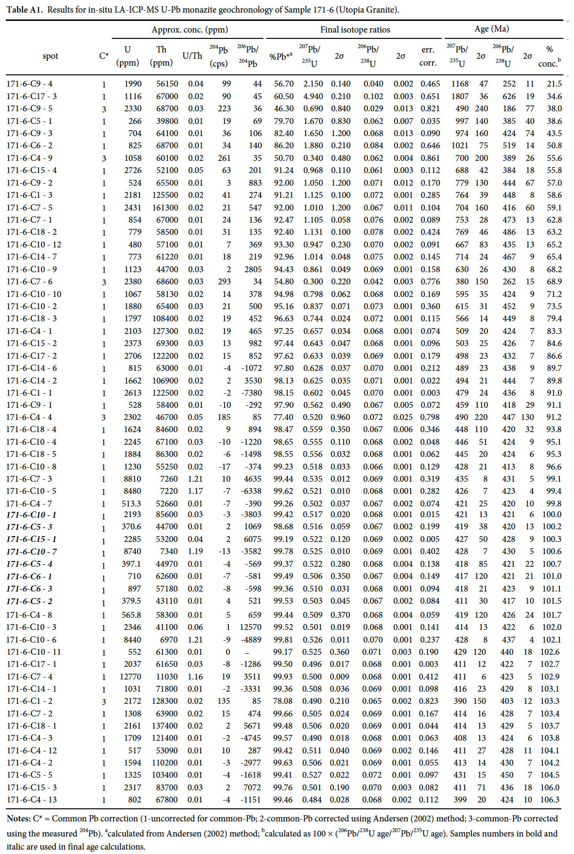 Display large image of Table A1Notes: C* = Common Pb correction (1-uncorrected for common-Pb; 2-common-Pb corrected using Andersen (2002) method; 3-common-Pb corrected using the measured 204Pb). acalculated from Andersen (2002) method; bcalculated as 100 × (206Pb/238U age/207Pb/235U age). Samples numbers in bold and italic are used in final age calculations.
 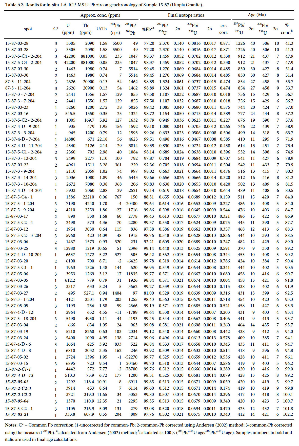 Display large image of Table A2Notes: C* = Common Pb correction (1-uncorrected for common-Pb; 2-common-Pb corrected using Andersen (2002) method; 3-common-Pb corrected using the measured 204Pb). acalculated from Andersen (2002) method; bcalculated as 100 × (206Pb/238U age/207Pb/235U age). Samples numbers in bold and italic are used in final age calculations.
  Display large image of Table A3Notes: C* = Common Pb correction (1-uncorrected for common-Pb; 2-common-Pb corrected using Andersen (2002) method; 3-common-Pb corrected using the measured 204Pb). acalculated from Andersen (2002) method; bcalculated as 100 × (206Pb/238U age/207Pb/235U age). Samples numbers in bold and italic are used in final age calculations.
 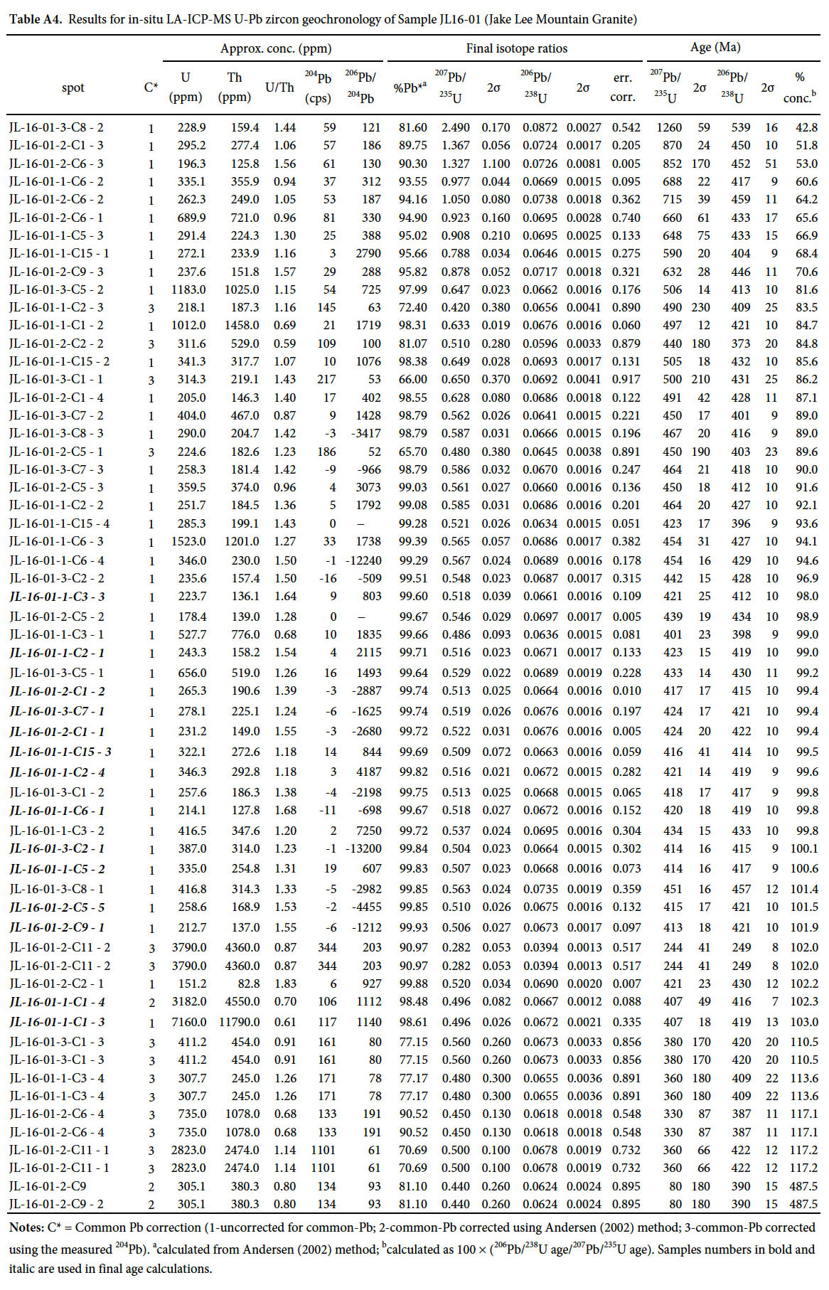 Display large image of Table A4Notes: C* = Common Pb correction (1-uncorrected for common-Pb; 2-common-Pb corrected using Andersen (2002) method; 3-common-Pb corrected using the measured 204Pb). acalculated from Andersen (2002) method; bcalculated as 100 × (206Pb/238U age/207Pb/235U age). Samples numbers in bold and italic are used in final age calculations.
 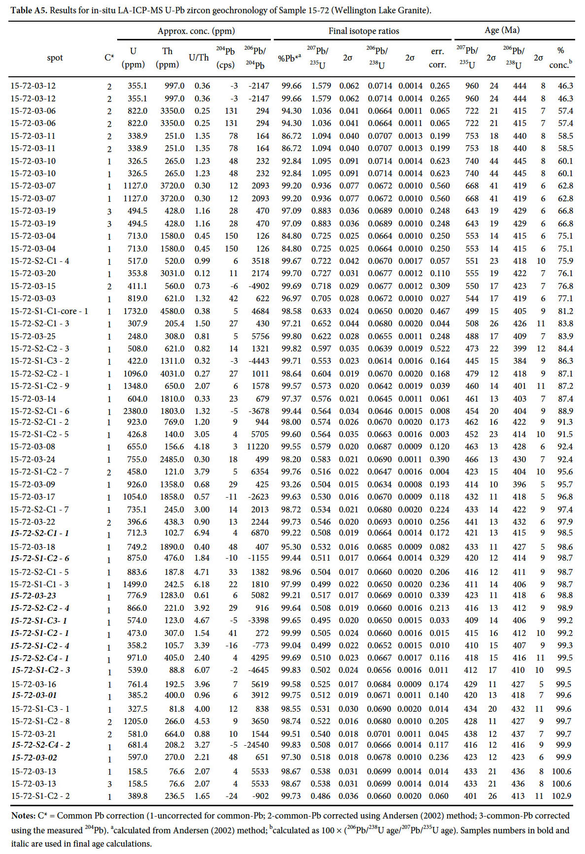 Display large image of Table A5Notes: C* = Common Pb correction (1-uncorrected for common-Pb; 2-common-Pb corrected using Andersen (2002) method; 3-common-Pb corrected using the measured 204Pb). acalculated from Andersen (2002) method; bcalculated as 100 × (206Pb/238U age/207Pb/235U age). Samples numbers in bold and italic are used in final age calculations.
 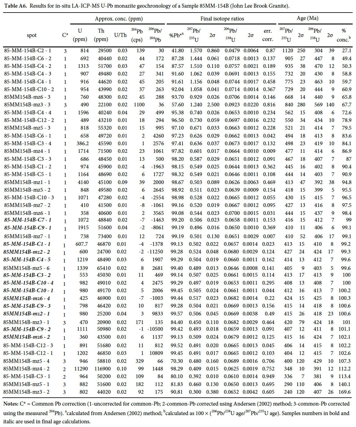 Display large image of Table A6Notes: C* = Common Pb correction (1-uncorrected for common-Pb; 2-common-Pb corrected using Andersen (2002) method; 3-common-Pb corrected using the measured 204Pb). acalculated from Andersen (2002) method; bcalculated as 100 × (206Pb/238U age/207Pb/235U age). Samples numbers in bold and italic are used in final age calculations.