Abstracts
Atlantic Geoscience Society ABSTRACTS
42nd Colloquium & Annual General Meeting 2016
TRURO, Nova Scotia
The 2016 Colloquium & Annual General Meeting was held at the Holiday Inn, Truro, Nova Scotia, on February 5th and 6th. On behalf of the society, we thank Colloquium organizers Tim Fedak, Bob Grantham, Rob Raeside, and Chris White, as well as the numerous student volunteers, for facilitating an excellent meeting. AGS acknowledges support from the corporate sponsors of the meeting: Fundy Geological Museum, Encana, Geological Survey of Canada, Nova Scotia Department of Energy and Department of Natural Resources, Geoscientists of Nova Scotia, Avalon Rare Metals, and Acadia University.
In the following pages, we are pleased to publish the abstracts of oral and poster presentations from the meeting, which included the following special sessions: (1) Recent Research in Petrology and Geophysics; (2) Recent Research in Sedimentary and Surficial Geology; (3) Recent Research in Economic Geology; (4) Dates, Rates, and Duration of Tectonic Processes-Timing is Everything; (5) Tin-related Mineralization and Exploration in the Maritimes; (6) Geoscience Education and Outreach: Creating an Awareness; (7) Offshore Geology of Eastern Canada; and (8) Advances in Carboniferous Geology in the Atlantic Provinces.
Also included with the conference was a day-long workshop on “QA/QC in Geology Research and Exploration” by Cliff Stanley (Acadia University). The guest speaker at Saturday evening’s banquet and social was Gerald Gloade (Mi’kmaq artist from Millbrook and Program Officer at Mi’kmawey Debert Cultural Centre) who gave an informative and entertaining presentation on Mi’kmaq legends in Atlantic Canada and how intertwined the relationship is between Glooscap and geology.
Problems and benefits relating to the use of existing drill hole data in assessing new provincial surveys - an under-utilized resource for industry, government, and academia.
1 Drill hole data that have been generated largely by mining companies are an under-utilized, but very important source of geoscience information in 3D space for use in context of evaluating new provincial survey data sets. By utilizing collar location data and measurements of the drill hole trajectory, the associated geoscience data have the potential to profoundly impact the effectiveness of new provincial data sets, ultimately leading to improved and more efficient evaluation by experienced geoscientists. Existing local and regional drill hole data add a third dimension to the assessment of new surface information by providing for stronger interpretation of the results in context of the subsurface data and its interpretation. There are hurdles to the ease of using drill hole data from digital assessment reports. The diversity of database formats, structures, and coding systems in the digital assessment files as well as the legacy of how and what data were entered are important issues. Early digital input of drill data revolved around a coded summary of the information which was often filtered by various database structure limitations and input forms/ formats. Further, most drill logs are very descriptive with long text fields that require parsing and coding into an expanded database structure while also retaining the original descriptions and impressions of the author. Historical, hard copy drill information is a challenge, but can be fully utilized subject to the time needed to parse the data and enter it into a functional database, again by an experienced geoscientist. Current industry database formats are fully capable of handling all information generated by the analyses of drill core as well as collection of in situ borehole data. In consideration of these observations, the primary constraints on the validity of historical drill hole data are (1) cartographic location of the holes and (2) the experience of the individual creating/compiling the log and entering the data. Presented are two case studies involving the successful digitization and utilization of historical and recent drill hole information in both grassroots and brownfields settings where surface exposures are greatly limited by till cover. The Somanike Project and the Matagami Area both in the central Abitibi Belt, Quebec, are two examples where hard copy compilation and use of existing digital data can be effectively used to add significantly to the subsurface understanding of above ground surveys. Accompanying these examples are recommendations on submission of digital drill hole data for assessment.
Timing of mineral and chemical changes following deposition, cooling, devitrification, and burial of the unusual alkaline pyroclastic rocks of the middle Cretaceous Crowsnest Formation, southwestern Alberta, Canada
2 The Crowsnest Formation is dominated by subaerial pyroclastic deposits containing crystal clasts and abundant heterolithic, juvenile, cognate and accidental rock clasts. Crowsnest rocks conformably overlie the fluvial-deltaic Blairmore Group and are unconformably overlain by the marine Blackstone Formation. The Crowsnest Formation is informally divided into a recessive, crystal-rich lower member dominated by air-fall, pyroclastic flow and pyroclastic surge deposits, and an upper member composed of massive, resistant pyroclastic breccias dominated by lithic fragments. Chemistry from cognate/juvenile rock fragments supports a compositional range using field terms from Blairmorite (sodic: analcime and lesser sanidine and melanite phenocrysts) to analcime phonolite (intermediate: sanidine, analcime and melanite phenocrysts) to trachyte (potassic: sanidine and melanite phenocrysts). Trachyte is dominant. Whole rock and REE data show that the deposits of the lower member fall within the trachyte and analcime phonolite fields whereas those of the upper member trend towards a newly identified hyper-potassic field (+10 % K20) related to the matrix of the upper member. Study of the matrix of the pyroclastic rocks in the <2 um size fraction combined with petrological and SEM analyses indicate significant differences between the upper and lower members despite rapid and continuous deposition. The matrix of the lower member is fragmental, but with significant development of clay minerals and the local presence of calcite. Remnant glass is present but rare. The <2 um size fraction is composed entirely of mixed-layer illite (65%)/smectite (35%), lesser discrete illite and chlorite. Conversely, the upper member has a micro-crystalline texture in the matrix and is dominated by a mix of K-feldspar, chlorite and discrete illite along with local calcite and other Crowsnest mineral constituents. Macroscopically, reaction between some cognate/juvenile lithic fragments and the matrix is observed. Deposition of the lower member is interpreted to have been under temperatures that initially preserved glass in the matrix while deposition of the upper member was at significantly elevated temperatures that induced recrystallization of the matrix during cooling and resulted in a significant reduction of porosity. The hyper-K composition likely aided recrystallization. Subsequent reaction with seawater produced an initial pure smectite phase in the matrix of the lower member while that of the upper member remained unaffected. Illite-smectite ratios indicate conversion of the initial smectite phase during burial and heating to ~200°C. The development of chlorite and discrete illite would have been facilitated in both members at this temperature; however, the micro-crystalline feldspathic matrix of the upper member remained relatively stable.
Digging up the Great Stone Chief
1. Prince Street, Wolfville, Nova Scotia B4P 1P7, Canada <aberger@bellaliant.net>
2. Department of Earth and Environmental Science, Acadia University, Wolfville, Nova Scotia B4P 2R6, Canada
3 Though Robert Bell (1841–1917) was one of Canada’s foremost pioneer geologists, he is largely forgotten today. While planning a book on the geomorphology of Canada, Prof. Ian Brookes (York University) came across Bell’s work on glaciation, and turned to a study of Bell himself. Brookes’ detailed biography, largely based on Bell’s extensive correspondence housed at Library and Archives Canada, and which was nearly complete at his recent death, is now being finalized by his colleagues for publication. Over his nearly 50-year career at the Geological Survey of Canada, Bell’s explorations made him widely recognized as an authority on geology, natural history, forestry, and ethnography. He mapped rivers draining into Hudson Bay, scouted out the route for a transcontinental railway, was medical and science officer on two expeditions to explore Hudson Strait, and “illuminated” the geology and mineral deposits of Sudbury and Cobalt, the Athabasca tar sands, and diamonds found in glacial sediments of the Great Lakes region. Along the way he gathered information on weather, ice and oceanographic conditions, forests, fauna and flora, and aboriginal peoples, who gave him the title “Great Stone Chief.” Bell was a charter member of the Royal Society of Canada, and was honoured at home and abroad. He was a frequent public speaker and government expert on national development, confident of a prosperous future for Canada. Despite his stellar service to the Survey, Bell was denied the title he really coveted and ended his career as ‘Acting Director’, not Director, of the Geological Survey. His output was prolific and his work unique, but not so his struggle with bureaucracy and political intrigue.
Geochemical analysis of uranium mobilization from the South Mountain Batholith and Horton Group siltstones in groundwater systems
Department of Earth Sciences, Dalhousie University, Halifax, Nova Scotia B3H 4R2, Canada <ol720301@dal.ca>
4 Many rock formations in Nova Scotia, particularly granitic rocks and siltstones of Devonian-Carboniferous age, may have an impact on the water quality of surrounding areas. Weathering and geochemical processes can mobilize uranium, which allows uranium to accumulate in groundwater systems in concentrations above recommended guidelines established by Health Canada. Certain geologic units consist of elevated uranium concentrations. Roll front-type mineralization is responsible for the high uranium concentrations found in the Horton Group siltstones that were used in this study. The South Mountain Batholith (SMB) is known to contain locally high uranium concentrations: late-stage mica-rich granites and monzogranites of the SMB contain elevated U concentrations. Uranium can also concentrate in late-stage fracture systems. Uranium mobilization is dependent on Eh and pH conditions as well as on the ions present in contact waters. In addition to naturally occurring U in groundwater, locally there are areas in Nova Scotia believed to have elevated U concentrations in groundwater systems credited to inputs from local construction waste disposal sites. This study focuses on the chemical agent or agents, both natural and anthropogenic that may be responsible for mobilizing uranium from U-bearing rocks. Road salts and sea water introduce ions into geologic formations that have a potential impact on uranium mobility. Gypsum, either in the form of gyprock in construction waste or as naturally occurring geologic formations, introduces calcium-sulfate into geologic systems, including groundwater. In this study ions such as chloride, sulfate, bicarbonate, calcium and sodium were added to crushed U-bearing rocks in an attempt to isolate the single variable (or variables) that mobilize uranium. The granite used in phase one of this study contained approximately 8.2 ppm U, but produced higher U concentrations in the resultant leachate than the Horton Group siltstone which contained approximately 20 ppm U. Interpretations from preliminary data suggest that the addition of CaSO4 has a greater impact on U-mobilization than CaCl2 which in turn has a greater impact than water alone. The effect of NaHCO3 on U-mobilization is dependent on rock type. Data analysis suggests that construction waste, mainly gyprock, may have an impact on U-mobilization.
Morphological examination of the NP-28 submarine channel-fan complex in the Amundsen Basin
1. Department of Earth Sciences, Dalhousie University, Halifax, Nova Scotia B3H 4R2, Canada <Kai.Boggild@Dal.Ca>
2. Department of Earth Sciences, Center for Coastal and Ocean Mapping, University of New Hampshire, Durham, New Hampshire 03824, USA
5 The NP-28 channel is a deep-sea turbidite channel supplying sediment to a submarine fan at latitudes between 85 and 90 N. The channel represents the northernmost submarine channel on Earth and was originally identified in 2004 using the International Bathymetric Chart of the Arctic Ocean dataset and three seismic profiles. Emerging hypotheses concerning the behaviour of high latitude submarine channels predict that straighter geometries may dominate at high latitudes due to the increased Coriolis forcing of sediment-laden currents. Sedimentation patterns within the NP-28 channel share similarities with experimental tabletop studies in which the location of the downstream velocity maximum is deflected at low Rossby numbers. This research examines the updated morphology of the channel and evaluates it in the context of these hypotheses.
6 Initial interpretations of the channel described an aggradational channel with consistent right-hand levee asymmetry stretching from the Klenova Valley into the Amundsen Basin. A compilation of multibeam echosounder data acquired in the past decade provides the first partial view of the plan geometry of the channel path, revealing a low-gradient, low-sinuosity channel running for more than 450 km parallel to the margin of Lomonosov Ridge. High-resolution 3.5 kHz seismic profiles across the channel-levee complex reveal turbidite system elements including confined levee terraces, tapered overbank stratigraphy and low-amplitude sediment waves. Overbank sedimentation on the right-hand side of the channel resulted in construction of large drift-like levee deposits which represent a substantial source of Quaternary basin fill in the Amundsen Basin.
Creating a glass fusion method for determining trace element composition of rock powders using LA-ICP-MS: a preliminary evaluation
Department of Earth Sciences, University of New Brunswick, P.O. Box 4400, Fredericton, New Brunswick E3B 5A3, Canada <b.boucher@unb.ca>
7 The ability to produce homogeneous and compositionally precise glass samples from an aliquot of crushed rock powder is an invaluable but potentially difficult technique for any laboratory that performs routine trace element analysis on solid material. Traditional analysis of powders (e.g., XRF) may not reach the detection limits required for in-depth geochemical characterization of complex samples, while other techniques can be time consuming and costly. Trace element analysis of both natural and synthetic samples can be easily performed using LA-ICP-MS provided that at least one major element exists in known concentration in the sample. This technique allows for high precision, low detection limits, and high throughput at a reasonable cost. Although laser ablation requires the sample to be in a coalesced, solid state with a properly matrix-matched exterior standard, various methods to fuse rock powders into glass beads have been investigated and have shown to yield promising results.
8 Using a strip heater, powdered standard reference materials (USGS SRM’s) have been mixed with a lithium meta/tetraborate flux and fused to produce glass beads with compositions that reflect the powdered sample. Once fused, these glass beads are analyzed via LA-ICP-MS and reduced using certified NIST glass standards (NIST610 and NIST612). Several such fusions have been analyzed using this technique over a wide range of elements (Be–U, 60 elements in all). Preliminary results show that USGS powders BCR-2 and GSP-2 can be fluxed and fused into glass beads that show minor heterogeneity and good reproducibility in trace element composition compared to their reference certificate. While some elements show a propensity to be highly variable and inaccurate (e.g., Ti, Zn, Zr), the rare earth elements (REEs) show promising reproducibility (RSD 5–10%) and concentrations that reflect the certificate value within 10%. Although several more steps are required to solidify this method, the strip heater fusion method coupled with LA-ICP-MS allows our laboratory to analyze a huge suite of samples quickly, and is a milestone in creating in-house standards to use for daily applications. Furthermore, the forthcoming addition of a bench-top micro-XRF system (Spring 2016) will enable the characterization of major elements of both powdered samples and flux-fused glasses using a calibration curve method.
Correlation and development of the Pineo Ridge–Sheldon Point Moraine Complex, northern Bay of Fundy, New Brunswick, Canada
Quaternary Studies Group, Department of Earth Sciences, University of New Brunswick, P.O. Box 4400, Fredericton New Brunswick E3B 5A3, Canada <broster@unb.ca>
9 In 2006 the Geological Survey of Canada at the Bedford Institute of Oceanography in conjunction with the Canadian Hydrographic Service and the Ocean Mapping Group at the University of New Brunswick commenced a three-year program to map the Bay of Fundy. A total of 427 sub-bottom lines representing over 6 500 km of seismic track lines, were examined. This data and recorded depth, multibeam bathymetry and backscatter, enabled the authors to delineate the character and thickness of stratigraphy and landforms for the northern Bay of Fundy sea bottom between Eastport, Maine and Saint John, New Brunswick.
10 Several landforms were clearly identified including, drumlins, flutes, end moraine, eskers, deltas, slump deposits, glacifluvial valleys, and outwash channels. Holocene material was delineated as marine sediments overlying a pervasive unconformity at depths up to 89 m. The Holocene sediments demonstrate scouring from grounded icebergs and pockmarks due to escaping gas, the latter attributed mostly to decay of organic matter buried by post-glacial sediments.
11 From these data we correlate the Pineo Ridge moraine of eastern Maine and the Campobello Island kame moraine, with the Sheldon Point moraine, located 70 km east-northeastward at Saint John. The Pineo-Sheldon moraine complex represents an ice terminal position that was buttressed midway across the Bay of Fundy by The Wolves islands. These associations are correlative with a moraine ridge that extends along the sea bottom approximately 10 km westward from Maces Bay and eastward along the coast to Sheldon Point. Sections of the moraine ridge are missing in deeper water surrounding The Wolves. It is likely that in areas of concentrated water flow, outwash from glacier melting removed sections of the Pineo-Sheldon end moraine, facilitating glacier retreat to a more stable grounded position where it constructed the St. George moraine and Pennfield–Pocologan delta complexes. The Sheldon Point moraine has been radiocarbon dated as 13 400 yBP with a calibrated date estimated to exceed 15 000 CalBP.
Lacustrine source rock potential in the Middle Triassic–Early Jurassic Chignecto Subbasin, offshore Eastern Canada
Canada-Nova Scotia Offshore Petroleum Board, 800 TD Centre, 1791 Barrington Street, Halifax, Nova Scotia B4A 3S5, Canada <dbrown@cnsopb.ns.ca>
12 Middle Triassic to Early Jurassic synrift extensional basins are exposed onshore eastern North America (Newark Supergroup) and extend into adjacent offshore areas with equivalent basins in Northwest Africa. Organic-rich lacustrine successions occur within the U.S. basins, and although no commercial discoveries have been made hydrocarbon shows in outcrops and a few wells confirmed that a working petroleum system existed. Their basin-fill model defines four tectonostratigraphic (TS) units. TS I is an unconformity-bounded, early synrift fluvial-eolian sequence of Late Permian age. TS II is a dominantly fluvial (with some lacustrine) sequence believed representative of an underfilled, hydrologically-open basin (subsidence < sedimentation). This is followed by either a closed basin or one in hydrological equilibrium (subsidence ≥ sedimentation) dominated by lacustrine (TS III) and later playa / lacustrine (and basal CAMP volcanics) successions (TS IV). Climate sensitive lacustrine facies - especially in TS III - are exquisite recorders of paleoclimate, and with paleomagnetic data refine the determination of the basins’ paleo-latitudinal positions.
13 Seismic profiles in the Fundy-Chignecto (Canada) and Newark (USA) basins reveal basin centre, high amplitude, laterally continuous reflections in both TS II and TS III. In the former, they are distal to up-dip fluvial successions and are interpreted as large, laterally equivalent deep-water lacustrine facies. This architecture departs from the TS model by inferring high levels of tectonically driven extension / subsidence and a hydrologically open basin. The seismic reflection character of interpreted fluvial and lacustrine successions mirrors facies associations that correspond to deposition in hydrologically open, overfilled (subsidence ≤ sedimentation) and hydrologically open and closed, balanced filled (subsidence ≈ sedimentation) lake basin types.
14 During TS II and III deposition (Late Anisian to Late Norian), paleomagnetic data positions these basins within the north equatorial humid and transitional belts that over time drifted towards the semiarid subtropical zone. Seismic data are interpreted to reveal their successions as representative of overfilled and balanced filled lake basin types. Together, this suggests a favourable setting for the creation of source rock intervals. Therefore, a potential new oil-rich resource play may exist within the faulted and fractured lacustrine successions of the TS II Wolfville and TS III Blomidon formations beneath Chignecto Bay. While recognizing that profound differences in water input, subsidence and resultant stratal successions can exist in adjacent and/or linked lakes, this interpretation may have significant impact for potential source rocks in Late Triassic lacustrine successions in pre-salt synrift basins offshore Nova Scotia and Morocco.
Did melting at ultra-high-pressure trigger exhumation of the Western Gneiss Region, Norway? Field testing a controversial hypothesis
1. Department of Earth Sciences, Dalhousie University, Halifax, Nova Scotia B3H 4R2, Canada <colin.bryden@dal.ca>
2. Norges Geologiske Undersøkesle, 7491 Trondheim, Norway
15 During the Scandian Orogeny (415–400 Ma), collision between Laurentia and Baltica resulted in the subduction of Baltican continental crust to mantle depths. The mechanism behind the subsequent exhumation of the Baltican margin is debated, with one hypothesis positing that melting at peak ultra-high pressure (UHP) conditions (≥3.5 GPa, 750–850°C) led to the detachment of buoyant upper crust from the down-going Baltica plate, thereby triggering the exhumation. This hypothesis requires the presence of fluids to lower the solidus temperature sufficiently to allow melting at the PT conditions reached at peak subduction depth. We present preliminary results of a field-based study to test this hypothesis in the Nordøyane UHP domain, the hottest and deepest part of the Western Gneiss Region (WGR), a tectonic window into subducted Baltican crust. Mapping at a scale of 1:2000 in two low-strain regions on the islands of Haramsøya and Flemsøya demonstrated that eclogite facies structures are well preserved, and that crosscutting relationships between various generations of fabrics and leucosomes can be distinguished. Multiple generations of leucosomes are present within the orthogneisses that host the eclogite bodies. These leucosomes locally cut the eclogites, but no clear field or petrographic evidence has yet been found for leucosomes generated within eclogite bodies themselves. Although xenocrystic garnet and pyroxene are common, the dominant mafic phase that crystallised from host rock leucosomes was hornblende, indicating that most partial melts crystallized at amphibolite facies. Throughout the study area, an enigmatic suite of granodioritic intrusions envelops, disaggregates, and partially assimilates the main eclogite bodies. These intrusions are associated with zircon-bearing, pegmatitic, scapolite-hornblende leucosomes which are being investigated to constrain the compositions and source of fluids present during crystallisation of late-stage melts. Results to date show that most scapolite is meionitic (Me 63-80), with significant Na (0.86–1.31 apfu), C (0.53–0.72 apfu) and S (0.21–0.41 apfu), but low Cl (0.01 to 0.11 apfu). Future work will include stable isotope analysis of C, S, and O in scapolite to characterize the composition and source of late-stage fluids, and U-Pb zircon geochronology to determine the time of melt crystallisation. The results will be used to test the hypothesis, based on our own field observations, that melting in the Nordoyane domain orthogneisses accompanied decompression of the UHP eclogites and thus cannot have triggered exhumation.
U-Pb geochronology of the southern part of the Saint George Batholith, including the Late Devonian Mount Douglas multiphase intrusion, southwestern New Brunswick, Canada: preliminary results
Department of Earth Sciences, University of New Brunswick, P.O. Box 4400, Fredericton, New Brunswick E3B 5A3, Canada <sbutler@unb.ca>
16 The Mount Douglas intrusion is comprised of a suite of peraluminous leucogranitic rocks that were crystallized from a melt that had undergone extensive fractional crystallization. It forms the main easternmost part of the Saint George Batholith and hosts numerous intragranitic Sn, W, and Mo occurrences. The Saint George Batholith is composed of five mappable suites: the Welsford intrusive suite, Digdeguash Lake intrusion (Bocabec Gabbro, Utopia Granite), South Oromocto Lake intrusions (Magaguadavic Granite, John Lee Brook Granite), the Mount Douglas intrusive suite, and the Late Devonian Pomeroy Intrusive suite. Similarities in texture, mineralization style, geochemical characteristics, and U-Pb dating suggest these units may be co-magmatic, and may indicate that the Mount Douglas Granite is a subvolcanic system that was responsible for the polymetallic mineralization at Mount Pleasant. Previous investigations using U-Pb geochronology on monazite grains show that samples from the John Lee Brook pluton report an age of 413 +/- 2 Ma, which indicates that this unit is older than the Magaguadavic pluton rather than younger.
17 A widely accepted and commonly used technique, in situ U-Pb analysis will be performed using LA-ICPMS on several samples from the southern contact of the Mount Douglas intrusive suite, where there are many outcrops of the Saint George Batholith that have similar petrography; SEM-BSE imaging of zircon and monazite grains in four separate granite samples is used to determine zoning features and core-rim relationships: this allows for precise placement of ablation spots during LA-ICP-MS U-Pb data collection. Analysis of monazite and zircon in several polished thin sections from each sample will help to constrain the absolute timing of the emplacement of the granite samples. This approach is designed to help distinguish any petrographic linkage between the sub-units of the Mount Douglas intrusion and the southern contact of the Saint George Batholith. Grains that show evidence of crystallization from magma and reveal no inherited cores are preferred for measurement to obtain the real crystallization age.
Nova Scotia’s geoheritage sites: the best possible educational resource
Nova Scotia Department of Natural Resources, P.O. Box 698, Halifax, Nova Scotia B3J 2T9 <John.H.Calder@novascotia.ca>
18 Nature cannot be trumped as a teacher, or as a resource for teachers. Rock and mineral kits have their place, allowing comparisons to be made of a wide variety of rock types, but nothing compares to the experience of a field trip to an exceptionally interesting outcrop of the Earth’s crust. Nova Scotia has an embarrassment of richness when it comes to exceptional examples of geology. This endowment is in part due to the variety of geological formations that together form Nova Scotia, and is in part due to the exposure of these sites by unrelenting coastal erosion. Every county within the Province of Nova Scotia has at least one designated geoheritage site, and one lies within a short distance of nearly every school. A sampling of Nova Scotian geoheritage sites from farther afield is featured on an ESRI StoryMap developed at NSDNR that can be previewed online at https://fletcher.novascotia.ca/geoheritage_ns_tour/index.html. The StoryMap captures the diversity of Nova Scotia’s geoheritage, but it also can help students realize that not all places have the same geology, the same landscape, and the same significance as their home town does: their backyard, if not unique, is really quite special. An important component of Nova Scotia’s Geoheritage List is the recognition of cultural geoheritage: sites where we humans have a history with the rocks. Such sites include historic mining areas and miners museums, and yes, miners’ memorials. It includes sites that commemorate some of the greatest geologists to have lived, and their works: Abraham Gesner, Sir William Dawson and Sir William Logan, and geoscientists of the modern era like Dr. Paul Schenk. Perhaps most significantly, the list includes sites that have been understood by the Mi’kmaw, and have been sacred to them, long before the word ‘geology’ was even coined.
Community engagement in Canada’s eastern Arctic
1. Geological Survey of Canada-Atlantic, Bedford Institute of Oceanography, Dartmouth, Nova Scotia B2Y 4A2, Canada <calvin.campbell@canada.ca>
2. Geological Survey of Canada-Pacific, Institute of Ocean Sciences, Sidney, British Columbia V8L 4B2, Canada
19 Since 2011, the Geological Survey of Canada (GSC) has carried out an active marine geological research program offshore Baffin Island, Nunavut. The research has been focused on understanding the offshore geological framework of the region and assessing marine geological hazards. As a federal agency, the GSC has a duty to consult and, where appropriate, accommodate when conducting research in regions that fall under Aboriginal or Treaty rights agreements. In the eastern Arctic, research licences are managed by the Nunavut Research Institute with the expectation that research results are presented directly to relevant communities. For the marine geology research in Baffin Bay, the GSC conducts annual community engagement tours to present research results, discuss new research activities, receive feedback on those activities, and adjust research plans based on that feedback.
20 As might be expected with work in Canada’s Arctic, the researchers face significant logistical challenges in coordinating this type of stakeholder engagement, including but not limited to: (a) weather, (b) availability of accommodations, (c) availability of key stakeholder groups, (d) a language barrier that necessitates the arrangement of oral and written translation services, and e) raising awareness of public meetings. Perhaps the most important challenge is gauging the success of the engagement. Despite these challenges, the experience has been highly rewarding for the researchers. The opportunity to communicate with communities and receive immediate feedback from stakeholders is vital to the success of the marine geological program.
Geochemical characterization of Lower Jurassic organic-rich facies, offshore Ireland
Basin and Reservoir Laboratory, PO Box 15000, Department of Earth Science, Life Science Centre, Dalhousie University, 1355 Oxford Street, Halifax, Nova Scotia B3H 4R2, Canada <Charlie.Carlisle@Dal.Ca>
21 Exploration of the Slyne Basin and Goban Spur, offshore Ireland, has provided significant hydrocarbon discoveries. During exploration of the Slyne Basin, Lower Jurassic intervals were identified to be viable hydrocarbon source rocks of regional significance. Stable carbon isotope chemostratigraphy can characterize organic-rich facies and trace changes in the various hydrocarbon sources, from continental environments and atmosphere to oceans and organisms. In marine environments, and particularly in epeiric sea settings, these processes are governed by the complex interplay of local (different carbonate producers, transgressive–regressive cycles) and/or global (worldwide preservation of organic matter, variation of continental weathering, input of volcanogenic light CO2) mechanisms.
22 In this study, we have analysed 34 core and cuttings samples from wells 18/25-1, 27/13-1 and 62/7-1 encompassing the Lower Jurassic. The selected samples were analysed by Continuous Flow–Isotope-ratio Mass Spectrometry (carbonates) and Elemental Analysis-Isotope-ratio Mass Spectrometry (organic matter) to determine 13C/12C ratio and calculate δ13C, along with bulk elemental geochemistry by X-ray fluorescence, for example in well 18/25-1, δ13C values in carbonates varies from -5.16 ‰ to +2.22 ‰ in well 18/25-1 while δ18O values range from -9.06 ‰ to -3.35 ‰. XRF shows all samples to be predominantly shale lithology, stretching to wacke. A negative isotopic excursion is identified in the samples, indicating the expression of the Toarcian Oceanic Anoxic Event. The δ13C values determined in the carbonate-free fraction presents less variation: a negative trend of -6.65 ‰ is observed in well 18/25-1 followed by a generally positive trend of +2.71 ‰ (-28.23 ‰ to -25.52 ‰). The obtained data were integrated with pre-existing Total Organic Carbon, pyrolysis Rock-Eval and Vitrinite Reflectance data to evaluate the origin of organic matter and the potential to produce hydrocarbon. The ongoing investigation will discern the palaeoenvironmental conditions that lead to this organic-rich facies offshore Ireland.
Black shale Selli Level recorded in Cretaceous Naskapi Member cores in the Scotian Basin, Canada*
1. Department of Geology, Saint Mary’s University, Halifax, Nova Scotia B3H 3C3, Canada <chavezg.isabel@gmail.com>
2. Natural Resources Canada, Geological Survey of Canada (Atlantic), Bedford Institute of Oceanography, P.O. Box 1006, Dartmouth, Nova Scotia B2Y 4A2, Canada
23 Climatic fluctuations between arid and more humid conditions in the Early Aptian favoured the deposition of black laminated organic-rich mudstones, including the Selli Level. The black shale intervals are recognised over large areas of Tethys and western European basins. This interval was investigated in a 75 m-thick continuously cored section of varicoloured shale in the lower Naskapi Member from the Panuke B-90 well in the Scotian Basin, offshore eastern Canada. This study complements the paleogeographic range of correlatable black shales and provides information on their relationship to sea-level change and paleoclimate. Total organic carbon (TOC) was measured on 127 discrete samples, chemical environmental proxies (Th/K, Mn/Ti, K/Ti, Th/Ti, V/Ti) were measured with a portable X-ray fluorescence (pXRF) spectrometer, and colour parameters L*a*b* were measured by spectrophotometer. Several black shale levels are recognised and correlated with similar shales in Europe between the Barremian-Aptian boundary and the Selli level. The Th/K ratio proxy for hinterland humid or arid climate conditions shows no systematic variation with black shale levels. Several sea-level lowstands are inferred from condensed sandy intervals with some brackish water biota and tidal sedimentary structures. Black shale intervals are found in high-stand intervals, with no systematic relationship to inferred transgressions. The formation of black shales is related to paleoceanographic changes that may be driven by conditions remote from the Scotian Basin.
An optimized method of unmanned aerial vehicle surveying for rock slope analysis, 3D modeling, and structural feature extraction
1. Department of Earth Sciences, University of New Brunswick, P.O. Box 4400, Fredericton, New Brunswick E3B 5A3, Canada <joseph.cormier@unb.ca>
2. Terrane Geoscience Inc. / Terrane Aerial Mapping, 2373 Moran Street Halifax, Nova Scotia B3K 4K1, Canada
24 Accurate and detailed mapping of structural geology is integral to the analysis of rock bodies for the design and construction of engineered rock slopes. Unmanned aerial vehicles (UAVs) can be used to complement traditional mapping techniques. UAVs can be used to map high walled or unstable slopes where safety considerations prevent human mappers from accessing the face. Additionally, significantly larger slopes can be mapped in less time, using a UAV.
25 A methodology is presented here using a camera-equipped quadcopter style UAV, coupled with DGPS ground points to produce a 3D photogrammetric point cloud and TIN model. Subsequently, discontinuity orientations are extracted from the point cloud model. Various commercial and open-source discontinuity extraction algorithms are tested for accuracy against joints set orientations measured with a compass.
26 The data processing variables tested in the photogrammetry point cloud generation stage include parameters for photo alignment and dense cloud generation. The photo alignment parameters are accuracy, pair preselection, key point limit, and tie point. Dense cloud generation variables tested are quality (point cloud density), and depth filtering. Additionally, variables tested in the Kd-Tree discontinuity extraction algorithm include maximum angle between neighboring patches, maximum distance between the merged patches and the current facet center, maximum difference of elevation for entities in a facet, minimum points per facet, and distance of facet influence from points. Optimal processing parameters will vary, depending on the relative size of exposed discontinuity dip-surfaces, relative to the point cloud density.
History is rheology: Paleoproterozoic accretionary zoning controls Grenville structural styles in deep crust of Neoproterozoic Grenville Orogen, Central Gneiss Belt (CGB), Ontario, Canada
1. Department of Earth Sciences, Dalhousie University, Halifax Nova Scotia B3H 4R2, Canada <Nicholas.Culshaw@Dal.Ca>
2. School of Earth and Environmental Sciences, Queens College, New York 11367, USA
27 A traverse across the CGB from the Laurentian craton to the Composite Arc Belt crosses three stacked tectonic zones of contrasting styles and tectonometamorphic history.
28 (1) The structurally deepest zone, overlying the Laurentian craton, comprises polycyclic parautochthonous domains that include the Archean basement of the inferred Paleoproterozoic Laurentian (Huronian) inverted passive margin. The Archean orthogneiss is associated with Paleoproterozoic metasediments containing detrital zircons suggesting Huronian protolith. Major overturned folds and amphibolite facies shear zones formed at ca. 1750 Ma (inversion of passive margin). A metamorphic and structural overprint at 1000 Ma resulted in narrow shear zones and fold interference patterns.
29 (2) Polycyclic allochthonous domains include Labradorian members of the Great Proterozoic Accretionary Orogen (GPAO). Ca. 1650 Ma orthogneiss was migmatized at ca.1450 Ma and ca. 1450 Ma A-type orthogneiss postdated the migmatization. Metasediments contain detrital zircon evidence for proximity to Penokean and Yavapai GPAO members. The complex Kiosk-Algonquin thrust stack contrasts with the fold interference patterns of the Archean parautochthons. The thrust sheets themselves display heterogeneous internal deformation and grain-size refined Ottawan (ca. 1080–1040 Ma) marginal shear zones. Retrogressed eclogites (1090 Ma met) lie within and along boundaries of some thrust sheets.
30 (3) Monocyclic allochthons, the highest zone, consist of the Pinwarian (ca. 1450 Ma) Shawanaga-Muskoka continental arcs (coeval with the back-arc A-type plutons in the polycyclic allochthons), the Parry Sound domain ca. 1314–1390 Ma arc and ca. 1232–1320 Ma back-arc assemblages that include sediments with Laurentian-GPAO provenance. The Pinwarian orthogneiss, lacking pre-Grenville melting of the polycyclic domains, is highly migmatitic and displays km-scale flow structures enabled by Grenvillian melt weakening. A boundary, decorated by an eclogite-anorthosite assemblage, separates the Pinwarian migmatitic orthogneiss and peripherally retrogressed granulite facies Parry Sound domain from the underlying polycyclic allochthons.
31 The traverse demonstrates the control exerted on structural style by GPAO accretionary zoning. The foremost control is Pinwarian, or earlier, high grade metamorphism, the presence of which favours formation of Grenvillian shear zones bounding relatively strong nappe cores. The absence of Pinwarian metamorphism in the outboard monocyclic arcs allows pervasive Grenvillian melting, softening and diffuse ductile flow.
Revisiting the stratigraphy of offshore Labrador: integrating sedimentological and palynological analyses with regional seismic data
Natural Resources Canada, Geological Survey of Canada, Dartmouth, Nova Scotia B2V 2A4, Canada <Lynn.Dafoe@canada.ca>
32 The Labrador margin developed through rifting as Greenland separated from the North American plate during formation of the Labrador Sea. Rifting began in the Early Cretaceous along the present-day shelf with active faulting migrating offshore during the mid- to Late Cretaceous, with breakup occurring by Chron 27 in the middle Paleocene. Our study builds upon previous work in the area by combining new well and seismic results with established frameworks to improve upon the stratigraphic resolution, including the timing of events and nature of missing sections in both the Hopedale and Saglek basins of offshore southern and northern Labrador, respectively. We integrate paleoenvironmental interpretations from core analyses, cuttings descriptions and well logs with new palynostratigraphic results and modern multichannel seismic data. The stratigraphic succession is composed of 4 major sequences. The lowermost sequence is Early Cretaceous in age and ends with a prominent unconformity at the top of the Bjarni Formation, of likely early Cenomanian age. New palynological results suggest that some of the Cenomanian through Santonian succession is missing at the base of sequence two. Later within sequence 2, a prominent flooding surface is present in the early–middle Maastrichtian. We use a more rigorous sequence stratigraphic framework for the late Cretaceous and Cenozoic section, where tectonic influences on margin stratigraphy decrease and paleoceanographic factors become more important. In the early Paleocene, the base of sequence 3 is marked by a major drop in relative sea level, which resulted in two distinct, prograding, forced regressive lobes of the Gudrid Formation. A maximum flooding surface of early Ypresian age caps the top of the Gudrid Formation and is followed by highstand progradation within the Kenamu Formation. A major late Oligocene–early Miocene sequence boundary marks the base of sequence 4. The sandy phase of this sequence is the Saglek Formation, which is characterized by progradational shelf edge deltas in the southern part of Hopedale Basin and heavily channelized successions to the north. These refinements to the stratigraphic framework aid in understanding deposition in offshore Labrador, and will be used in future studies as an analogue that can be applied to the stratigraphy in Baffin Bay, which shares a similar tectonic history to the Labrador margin.
Untangling the synrift and early post-rift development of the central Scotian margin, eastern Canada
Canada-Nova Scotia Offshore Petroleum Board, 1791 Barrington Street, Halifax, Nova Scotia B3J 3K9, Canada <mdeptuck@cnsopb.ns.ca>
33 Much of our knowledge about the synrift stratigraphic and structural development of the Scotian margin comes from the well-studied Fundy Basin, a large and deep eastern North American rift basin that underlies, and crops out along, the Bay of Fundy, Minas Basin, and Chignecto Bay, more than 450 km landward of where the continental crust ruptured and oceanic crust was emplaced. A number of lesser known rift basins are preserved more than 175 km seaward of Fundy Basin, beneath the central Scotian Shelf and Slope. Correlation of a Moho reflection, as well as a complex array of mid-crustal shear zones and dominantly landward dipping border faults, coupled with improved mapping of the top of basement, helps constrain crustal thickness and provides information about how the crust beneath the shelf and slope accommodated extension. Synrift strata in these basins record a complex but poorly-calibrated multi-phase extensional history with seismic data indicating at least two important breaks in the stratigraphic record and one period of widespread folding that predate the postrift unconformity. More than 3 km of heavily faulted and unpenetrated early synrift strata in the Naskapi, Mohican, Acadia, and Oneida grabens pass upsection across a disconformity into a ~1 km thick Upper Triassic layered succession of halite and red dolomitic shale and siltstone capped by CAMP-related lava flows. These rocks in turn are conformably overlain by up to 800 m of unpenetrated strata presumed to have accumulated in the Early Jurassic. Subsequent Early(?) Jurassic folding of this Upper Triassic and Lower Jurassic synrift succession produced a number of distinctive narrow, NE-trending longitudinal folds with axes that parallel active landward-dipping border faults. Erosion of the fold crests produced a prominent angular unconformity which, along with underlying Lower Jurassic strata, are best preserved along fold synclines and where continued basement extension generated additional hanging wall rift accommodation adjacent to more elevated basement elements (footwall). Careful study of these basins provides new insight into the synrift and early postrift margin development closer to where the crust ruptured and far removed from sinistral strike-slip motion along the Cobequid-Chedabucto fault systems that apparently inverted Triassic and Lower Jurassic strata in the Fundy Basin.
The Great Sohm Dome: a Paleogene stratigraphic high in the Sohm Abyssal Plain, Canada
Natural Resources Canada, Bedford Institute of Oceanography, 1 Challenger Drive, PO Box 1006, Dartmouth, Nova Scotia B2Y 4A2, Canada <kevinjoseph.desroches@canada.ca>
34 The Sohm Abyssal Plain is a large, deep-water depocentre off the Nova Scotian margin. A seismic reflection survey performed in 2007 by Natural Resources Canada as part of the research program related to the United Nations Convention on the Law of the Sea (UNCLOS) reveals a previously unknown Paleogene high centered near the Gregg and San Pablo seamounts, about 150 km northeast of the centre line of the New England Seamount chain. Given the limited resolution allowed by the seismic survey and lack of geophysical signature, the high appears as a dome-like feature approximately 300 km across. It was a positive depositional feature affecting deposition at the end of the Cretaceous and throughout the Paleogene. The exact cause of the uplift is not known; however, its proximity to the New England Seamounts makes it tempting to draw a possible connection.
Using local materials and simple ideas to explain geoscience
1. Department of Geology, Saint Mary’s University, 923 Robie Street, Halifax, Nova Scotia B3H 3C3, Canada <howard.donohoe@smu.ca>
2. APGNS, P.O. Box 91, Main Stn, Enfield, Nova Scotia B2T 1C6, Canada
35 Local buildings, walls, streets, rip rap, and building stones provide a wealth of information for teachers and geoscientists to discuss geological materials and geological processes. Geoscientists have an important role in helping teachers and students [and the general public] to appreciate common geological materials and processes. Common places for these materials are to be found in school buildings and grounds, city and town streetscapes, and coastal areas. Teachers and geoscientists who are working with topics in geoscience can use local materials and simple ideas to illustrate more complicated and larger scale geological thoughts. An example of a simple idea if hardness testing of minerals. Some minerals are harder than others. Using an easy to understand demonstration, teachers invite students to scratch a sandstone from northern Nova Scotia and a granite from southern Nova Scotia. The discussion following this may lead to an understanding that some rocks are hard and some are soft. Hardness can then be moved to discuss why some land is higher in elevation that other areas. The questions about “why mountains” can be explored. Adding limestone and the acid test [with supervision] allows students and the public to comprehend the effect of chemical reactions on earth materials. Using common examples from streetscapes and along the coast, geoscientists are able to help students, teachers and the public appreciate the rate of change from either natural and/or human-induced processes. As teachers and geoscientists use methods of inquiry that rely on observation, non-difficult conclusions, and transfer of knowledge, they encourage students and the public to see the earth around them, notice the effects of geological processes and build their own knowledge through active, experiential learning.
Probable Middle Carboniferous NW-SE faulting in the Musquodoboit Valley, Nova Scotia, Canada
1. Department of Geology, Saint Mary’s University, 923 Robie Street, Halifax, Nova Scotia B3H 3C3, Canada <howard.donohoe@smu.ca>
2. Dartmouth, Nova Scotia, Canada
3. APGNS, P.O. Box 91, Main Stn, Enfield, Nova Scotia B2T 1C6, Canada
36 The search for potable groundwater has led to more information about post-Early Carboniferous NW-SE faulting in the Musquodoboit Valley. Scouts Canada’s Camp Nedooae located several kilometres north of Elderbank, Nova Scotia, needed several wells for an additional water source. Previous geological maps of the area do not suggest NW-SE faulting. The Valley in this location has a relatively thick cover of till and very few outcrops so knowledge of the bedrock is based on extrapolation from limited outcrops and relatively uncomplicated structure. The camp location was thought to be near a Goldenville Group basement high just to the north. Gently south-dipping Windsor Group shale, evaporite and limestone lie unconformably on the older rocks. Instead of finding the base of the Windsor Group and the unconformity, the first well (east block), 0.5 km southeast of Brown Lake was collared in Goldenville Group. The second well, 0.6 km west, was collared in gypsum and bottomed in limestone/dolostone with interlayers of gypsum. No fossils fragments were found anywhere in the well cuttings. We now surmise that the east block moved up and the west block moved down. With this knowledge of the bedrock and some topographic trends, we now believe NW-SE faulting has played a greater role in rock distribution in the Valley. Geological evidence of NW-SE faulting is not readily apparent in this area. None of the Early Cretaceous deposits have mapped offsets in this orientation. In the Rawdon area to the west small NW-SE faults offset the Horton Group and a WSW-ENE bounding fault. The throw is east side up. NW- trending faults are known in the Cobequid Mountains and of course in southern Nova Scotia. The small amount of new evidence in the Musquodoboit Valley suggests there is an important addition to the geological history of this region.
A magnetic fabric study of the sheeted Greendale Igneous Complex of the Antigonish Highlands, Nova Scotia, Canada: preliminary results
1. Department of Earth Sciences, St. Francis Xavier University, Antigonish, Nova Scotia B2G 2W5, Canada <x2016mgz@stfx.ca>
2. Department of Earth & Environmental Sciences, University of St Andrews, St Andrews KY16 9AL, UK
3. Environmental Geology, Natural Resource Management Department, New Mexico Highlands University, Las Vegas, New Mexico 87701, USA
37 The Greendale Igneous Complex is a ca. 607 Ma old, dominantly mafic pluton located on the northern shore of the Antigonish Highlands within the Avalonia composite terrane. It is dominantly composed of appinites (hornblende and plagioclase rich gabbro) emplaced along sheet-like horizons with minor conjugate syn- to late felsic dykes and local horizons of ultramafic rocks. While compositionally similar, the sheets exhibit variable textures (aplitic to pegmatitic) and fabrics (strongly lineated and foliated to massive, equigranular sheets). The development of the sheets is believed to be controlled by the transpressional regional stress field caused by the dextral movement of the Hollow and Greendale faults located to the NW and SE of the complex, respectively. We present new Anisotropy of Magnetic Susceptibility (AMS) and paleomagnetic data to assess the structural and tectonic controls on the emplacement of the Greendale Igneous Complex.
38 A total of 34 sites over two different localities were sampled for magnetic fabric analysis. Curie point measurements indicated that pyrrhotite is the dominant ferromagnetic phase with minor magnetite in some samples. The concentration of ferromagnetic minerals is locally variable, however, and is not consistent along strike or across sheet boundaries, with many sampling sites containing no ferromagnetic material at all. Isothermal remanent magnetization acquisition curves on sample sites with the highest mean susceptibilities reached 95% saturation at less than ≤0.2T demonstrating that the magnetic remanence of the rocks is carried by ferromagnetic minerals with low coercivity. The magnetically soft nature of the rocks prevented the successful use of paleomagnetism analysis through typical alternating field demagnetization. Alternative techniques such as thermal demagnetization yield improved results in some cases and warrant further study. Anisotropy of magnetic susceptibility analysis successfully produced AMS tensors that can be interpreted as magnetic foliations or lineations, or both. Comparison of the magnetic fabrics with field maps along strike of the appinite sheets and across sheet boundaries can provide important constraints on the emplacement of the sheets and the evolution of the regional stress field of the system over time. Preliminary observations show that the shape and orientation of AMS tensors are generally consistent along strike within sheets but vary from sheet to sheet, suggesting that the fabrics are magmatic in origin.
Provenance of Lower Jurassic to Lower Cretaceous clastic sedimentary systems in the SW Scotian Basin and the Fundy Basin, Canada
1. Department of Geology, Saint Mary’s University, Halifax, Nova Scotia B3H C3C, Canada <cezardanny@yahoo.gr>
2. Natural Resources Canada, Geological Survey of Canada (Atlantic), Bedford Institute of Oceanography, P.O. Box 1006, Dartmouth, Nova Scotia B2Y 4A2, Canada
39 Lower Jurassic to Lower Cretaceous clastic deposits in the SW Scotian Basin and the Fundy Basin, offshore Nova Scotia, are poorly known, but are of current exploration interest. This study determined sediment sources and potential river patterns for these Mesozoic sandstones. Samples from conventional cores and cuttings were analyzed by scanning electron microscope and electron microprobe to identify detrital minerals (heavy and light) and lithic clasts, and determine their geochemical composition. The chemistry of detrital minerals, particularly tourmaline, garnet, spinel, micas and chlorite, and texture and mineralogy of lithic clasts were used to determine provenance.
40 During Early Jurassic, clastic sediments were deposited only in the Fundy Basin. The abundance of magnetite suggests a local major supply from the North Mountain Basalt, which is the only magnetite parental rock around the Fundy Basin. Lower Jurassic detrital mineral chemistry indicates derivation from metamorphic rocks of the Meguma terrane and a small influence from distal sources to the north. Sediments with local character were transported by small local rivers from the Meguma terrane, flowing along the Cobequid-Chedabucto Fault Zone and directly from the North Mountain Basalt. More distant rivers probably passed through Chignecto Bay before depositing in the Fundy Basin.
41 In the SW Scotian Basin, detrital minerals and their inclusions, and mineralogy of lithic clasts in Mid Jurassic sandstones indicate a major Meguma terrane source, and transport by local rivers. Small amounts of spinel and garnet characteristic of meta-ultramafic rocks, found only in the Mohawk B-93 well, suggest minor supply from the rising Labrador rift, via a river running along the Cobequid-Chedabucto Fault Zone and across the Fundy Basin. The abundance of metamorphic lithic clasts in the sandstones suggests uplift and intense erosion of the Meguma Supergroup metasedimentary rocks. Upper Jurassic sandstones were sourced entirely from the Meguma terrane. Lower Cretaceous sandstones were also predominantly sourced from the Meguma terrane, but in Mohican I-100 well minor garnet from meta-ultramafic rocks and spinel suggest some supply from Labrador and inboard Appalachian terranes, which were the principal sources of sediment to the central Scotian Basin at that time. The dominant Meguma terrane provenance precludes thick deep-water sandstones in the eastern Shelburne subbasin, but the evidence of Mid Jurassic distant river supply through the Fundy Basin is encouraging for deep water reservoir quality in the western part of the subbasin.
Finding the Dorchester Fault
Department of Earth & Atmospheric Sciences, University of Alberta, ESB 1-26, Edmonton, Alberta T6G 2E3, Canada <egglesto@ualberta.ca>
42 The Maritimes Basin of Atlantic Canada is a 148 000 km2 basin, filled from the Late Devonian to the Permian; it contains smaller depocentres or subbasins, usually less than 4000 km2, separated by fault-controlled basement uplifts. The Sackville and Moncton subbasins are located in southeastern New Brunswick. The Moncton subbasin extends westward over a large area that lies to the north of the Caledonia Highlands basement uplift, whereas the Sackville subbasin terminates to the west against the uplift. The two are separated by the Dorchester Fault, a major structure identified in surface geologic maps, extending from the Caledonia Highlands in the southwest through Albert Mines to Upper Dorchester and farther northeast. The Dorchester Fault juxtaposes Horton Group and basement rocks to the northwest against Windsor Group to the southeast. East of the Petitcodiac River the fault has been previously interpreted as moderately south-dipping.
43 Seismic data suggest that the mapped Dorchester Fault includes two distinct structures. Near Upper Dorchester, a south-dipping boundary visible on seismic profiles separates Mabou and Windsor Group rocks from basement and Horton Group. This SE-dipping boundary is interpreted as the northeast part of the mapped Dorchester Fault, which we distinguish as the Upper Dorchester Fault. Traced downdip, the boundary meets another surface interpreted as a major NW-dipping fault which we distinguish as the Lower Dorchester Fault. The intersection point of the Upper and Lower Dorchester Faults forms the tip of a tectonic wedge that has been inserted southward into Windsor Group evaporites. Traced to the southwest, the tip of this wedge progressively shallows in the subsurface, reaching the surface near the Memramcook estuary. Farther southwest, only the Lower Dorchester Fault is preserved. Its geometry in seismic profile better matches the mapped Dorchester Fault seen near Albert Mines, where a splay in the hanging wall has previously been identified as the Edgetts Landing fault.
44 The Lower Dorchester Fault meets a steep NE-SW boundary at depth. This boundary is a near vertical strike-slip fault, yet unnamed, that bounds the Stoney Creek oil and gas field along its southeast edge. Traced updip, this boundary is truncated by Windsor Group reflectors, indicating that movement was pre-Viséan. Localized unconformities within the Horton Group indicate a complex history of Tournaisian movement. When the seismic data are artificially flattened along Windsor Group reflectors, restoring the pre-Viséan geometry, the two faults are seen to define a flower structure, further supporting the strike-slip interpretation.
Embracing citizen science for promoting geoscience education in Nova Scotia, Canada
Fundy Geological Museum, PO Box 640, 162 Two Islands Road, Parrsboro, Nova Scotia B0M 1S0, Canada <tim.fedak@novascotia.ca>
45 Citizen science involves providing members of the public with an opportunity to collaborate and contribute to scientific research projects. There are many forms of citizen science; some involve private collectors and academic researchers, while others involve the design of special research projects to engage members of the public.
46 Eldon George was recognized for his contributions to developing tourism and rural economy of the Town of Parrsboro and Cumberland County, receiving the Order of Nova Scotia in 2013. The same year Eldon received the Laing Ferguson Distinguished Service Award from the Atlantic Geoscience Society. The Fundy Geological Museum (Cumberland Geological Society) is now establishing an exhibit to recognize Eldon’s contributions to highlight his work as a citizen scientists and private collector.
47 Mr. George devoted a lifetime established expertise in fossil and mineral collecting, finding his first fossil at the age of eight and opening the Parrsboro Rock and Mineral Shop in 1948. His collaborations with researchers such as Donald Baird (Princeton) and Paul Olsen (Lamont Doherty) have been particularly important for the region, providing important specimens of Carboniferous fish skulls as well as Carboniferous and Mesozoic footprints. In 1957 National Geographic magazine published an article on the “Great Tides of the Fundy” that included photos and text describing Eldon’s rock collecting interests.
48 Throughout his career Eldon worked at the Nova Scotia Museum (as Assistant to Peter Von Bitter), and as a field geologist surveying sites across New Brunswick and Nova Scotia. However, the focal point of his life’s work was directed to the Parrsboro Rock and Mineral Shop and Museum. By sharing his enthusiasm and knowledge with all tourists and professional geologists that visited his shop, Eldon inspired a generation of professional and amateur geologists.
49 While building an exhibit to pay tribute to the legacy of Eldon George, the Fundy Geological Museum also seeks to continue to offer public with opportunities to engage the public with citizen science projects. New projects at the Museum will provide opportunities to volunteer in the Fossil Research Lab, or assist as a volunteer in palaeontology field work. The goal of these new citizen science projects are to encourage an interest in geoscience and promote science literacy among the general public.
Peddling the rock cycle: vignettes to explain the most fundamental Earth system
1. Geological Survey of Canada (Atlantic), Natural Resources Canada, Bedford Institute of Oceanography, Dartmouth, Nova Scotia B2Y 4A2, Canada <rob.fensome@canada.ca>
2. Natural Resources Education Centre, Nova Scotia Department of Natural Resources, P.O. Box 100, Middle Musquodoboit, Nova Scotia B0N 1X0, Canada
3. Storytellers Circle of Halifax, 44 Ellenvale Avenue, Dartmouth, Nova Scotia B2W 2W5, Canada
50 Collaboration between the Atlantic Geoscience Society (AGS) and the Photographic Guild of Nova Scotia (PGNS) has been underway for over 15 years and includes a competition within PGNS, sponsored by AGS. Under the rules of the competition, images entered may be copied and kept by AGS and used in its outreach activities. Images in the collection now number several hundred and, in thinking of a way to use this resource in a retrospective presentation of the collaboration, the lead author had the idea of using the images to tell the story of the rock cycle. The resulting presentation included a mixture of images from the Guild and others, the latter to fill gaps; it also (with help from Guild members) involved narration and music. With the AGS Video Committee planning a series of vignettes rather than “feature-length” videos, it was suggested that the rock cycle might be a good theme: the Committee agreed and an ad hoc committee (the current authorship) was struck to develop the idea. We are currently considering two possibilities, one based on PGNS images, with a global perspective; and one with a more regional aspect - “A Nova Scotia Rock Cycle” based mainly on the lead author’s collection of thousands of images. These vignettes would include simple graphics as well as photographs, and an entertaining but informative narration will be developed. Several factors need to be considered: for example, the target audience, and at what part of the cycle to start the presentation. The first rocks on Earth were igneous, so a focus on such rocks would make a logical beginning. But would it be more intuitive for a general audience to start with sediment? There will be a need to balance close-ups and landscapes, to vary colour and locations (though hard not to overload on the geologically gorgeous Parrsboro shore for the Nova Scotia version), and to avoid overly technical images and subjects. If these rock-cycle vignettes prove to be successful, similar vignettes could be planned for other jurisdictions (for example, New Brunswick) and other topics, such as plate tectonics and the Maritime’s journey from the South Pole to mid-northern latitudes.
Dinoflagellate gems from the GEM project: aspects of Mesozoic-Cenozoic biostratigraphy from Canada’s North
1. Geological Survey of Canada (Atlantic), Natural Resources Canada, Bedford Institute of Oceanography, Dartmouth, Nova Scotia B2Y 4A2, Canada <rob.fensome@canada.ca>
2. Department of Earth Sciences, Dalhousie University, Halifax, Nova Scotia B3H 4R2, Canada
51 The latest phase of Geological Survey of Canada’s Geoscience for Energy and Minerals (GEM) project involves six regions of interest spread across northern Canada, from Baffin Bay to the Cordillera. Rocks of these regions include marine Mesozoic and Cenozoic rocks, which are important in evaluating the geology and petroleum systems of several GEM regions. Dinoflagellate cysts (dinocysts) are a key tool in establishing the ages of Jurassic through Neogene marine strata, and together with other palynomorphs (notably spores and pollen) they are an important source of paleoenvironmental information. Our work is currently focussed on using dinocysts and other palynomorphs to elucidate the Cretaceous–Paleogene stratigraphy within two GEM regions of interest: the Baffin Bay area and the Mackenzie region of western Northwest Territories and eastern Yukon. In the Baffin region, the sections studied are from three areas on Bylot Island: Maud Bight, Two Snout Creek, and the South Coast. Collectively, the sections encompass Albian–Cenomanian to middle Paleocene (Selandian) rocks, previously dated using only spores and pollen. The dinocyst assemblages are refining the age control and highlighting previously unsuspected fluctuations in the marine paleoenvironments. Mesozoic rocks in the Mackenzie region form a key link between the better-dated strata of the Western Interior Seaway further south and coeval strata of the Western Arctic. The Hume River section northwest of Norman Wells has been examined previously using foraminiferal assemblages, but some stratigraphic problems still remain, such as the position of the Albian–Cenomanian transition and the dating of an important unconformity between the Arctic Red and Slater River formations. Dinocysts are being applied to address these problems. Analyses of assemblages in the Hume River section will also provide a benchmark for expanding to other sections in the region and for establishing biostratigraphic events to correlate to other GEM regions. The Hume River section has yielded a rich variety of areoligeracean dinocysts of the genus Cyclonephelium and related forms, and these are providing core material for a taxonomic revision of that complex in anticipation of their improved utility for biostratigraphy.
Radioactive REE and Y mineralized zone in Highland Falls, New York: petrogenesis and metasomatic reactions
Department of Earth Sciences, University of New Brunswick, Fredericton, New Brunswick E3B 5A3, Canada <e.a.garcelon@gmail.com>
52 In southeastern New York State, within the Mesoproterozoic Grenville Orogen, the Hudson Highlands inlier is metamorphosed to granulite facies, consisting primarily of locally migmatitic paragneiss, and is intruded by late tectonic granites and pegmatites. At a contact between the migmatite and paragneiss (apparently conformable), a narrow vein-like zone is composed almost entirely of monazite and xenotime (mz-xt zone), and surrounded by a metasomatic biotite envelope. The mz-xt zone is approximately 0.25 m wide and >4m in extent in the outcrop, while the biotite envelope is up to 0.75 m wide. It is weakly deformed, steeply dipping (80°), and strikes NNE. The mineralized zone contains up to 1.0% U, 3.0% Th, 25% total REE, and 13% Y, with Eu/Eu* = 0.03 and La/Yb = 3.0. Previous studies of this zone have investigated age and mineral trace-element characteristics; cores of zircon, monazite, and xenotime in the mz-xt zone have a U-Pb age of 1036 ± 5 Ma, and a series of rims were dated between ca. 1034–890 Ma, formed during subsequent metasomatic events. This zone postdates the host paragneiss (ca. 2065–1270 Ma) and the local granitic intrusions (1058 ± 14 Ma). In this study, the host paragneiss and metasomatic biotite zone are examined via lithogeochemistry, biotite mineral chemistry, and petrography to understand the source of metasomatic fluids. Based on electron probe microanalysis (EPMA), biotite in this system is classified as magnesian siderophyllite and is highly enriched in Cl, with up to 2.3 wt.% Cl. Using Henry et al. (2005) Ti-inbiotite geothermometry, the biotite in the metasomatic zone formed at 542 ± 24 °C. Cl and F concentrations in the biotite and charge balance methods were used to estimate fugacities in the system. Average log(fH2O)/(fHCl) = 2.8, and log(fH2O)/(fHF) = 4.3, values more Cl-dominated than most published alteration systems. Using whole-rock chemical compositions of the metasomatic zone versus unaltered host-paragneiss, mass balance methods were used to calculate the compositional losses and gains of the biotite zone associated with metasomatism. The main elements lost were Si, Na, Ca, and Sr, consistent with the reaction of alkali feldspars with KCl and FeCl2 to form Ferich biotite (~ 550 °C and 5 kbar). The very high chlorine activity, along with salt-rich fluid inclusions in albite and monazite, and the extreme enrichment in incompatible elements suggest that the vein-like mz-xt zone was formed from a hypersaline brine with low Ca, probably derived from a highly fractionated, late tectonic pegmatite.
Awareness via Science East’s career-based school programs
Program Coordinator, Science East, 668 Brunswick Street, Fredericton, New Brunswick E3B 1H6, Canada <becky.geneau@scienceeast.nb.ca>
53 Science East is New Brunswick’s most active public science and technology education organization and is recognized nationally amongst Canadian science centres as providing some of the best science education outreach programs in the country. All Science East programs and services are available in both official languages.
54 Though physically located in Fredericton, the vast majority of Science East’s work takes place outside the science centre via extensive outreach in every region of the province. In 2014–2015, Science East had 15 200 visitors at the science centre and served another 31 000 across the province through outreach. For example, in the last 5 years, the 1–4 day Illuminate STEM career program has engaged over 20 000 New Brunswickers. In May of 2014 Science East was awarded the prestigious Best Outreach Program in Canada by the Canadian Association of Science Centres (CASC) for the Illuminate: Shedding Light on Science, Technology, Engineering and Math (STEM) career-based program. This award is given each year for the best educational, interpretive, or public program in Canada. In 2009 Science East won this same award for the Nights of Environmental Science program which continue to run strong. The award is a significant testimony to the quality of these programs.
55 Science East places an imperative in all its programs and services on addressing the disconnection between education and the world of work and has established a network of over 500 individual New Brunswick science and technology content partners. These businesses, researchers, non-profits, public agencies, innovators and entrepreneurs are drawn from the surrounding communities and regions in which Science East programs take place. These content partners come to the local schools to showcase hundreds of ways that past, present and future tools and technologies are improving lives in our province and changing the way we do things.
56 Recently, Science East has added Envirothon NB: the Province’s largest environmental science high school competition to its repertoire. Participants gain valuable knowledge and training in ecology and natural resource management principles and practices. Many students step away from the Envirothon experience excited about learning and motivated to pursue careers in environmental studies, environmental law, natural sciences, and natural resource management.
57 The Centre has been designing and delivering hands-on and inquiry-based experiential science education since 1994.
A study of salt domes in the Carboniferous Wallace Sub-Basin, Nova Scotia, Canada
Department of Earth Sciences, Dalhousie University, Halifax, Nova Scotia B3H 4R2, Canada <nt660911@dal.ca>
58 Through fluid inclusion analysis the paleoenvironment that existed during evaporite formation can be determined when considering undeformed salt deposits. However, inferring the paleoenvironment of salt diapirs becomes more difficult due to recrystallization processes that occur during deformation. The Wallace No. 1 core was drilled into one such salt dome located in the Cumberland Basin in the northern Nova Scotia. The drill hole penetrated through the eastern flank of a large anticline cored with evaporites; mainly halite, anhydrite, gypsum and lesser occurrences of sylvite and carnalite. This deposit is heavily deformed, with preserved beds dipping between 40 and 60 degrees. These circumstances make it more difficult to determine seawater chemistry from conventional methods, such as fluid inclusion studies. However, preserved beds of mudstone do exist along with clear and dark grey-banded halite layers. In addition, thin sections depict preserved ‘snow-on-roof’ textures, with halite crystals being capped by anhydrite, exhibiting cyclic repetition. These preserved bedforms and textures indicate the possibility that not all of the deposit was reset during deformation. Through examining anhydrite grains, and looking at the trace elements incorporated into their structure, modeling techniques can be applied to examine, indirectly, ancient seawater compositions. These compositions can then be compared with existing data from nearby, undeformed samples, and modern analogs, to determine whether salt domes can preserve original seawater geochemistry despite deformation and recrystallization processes. If this is the case, salt domes may be used to help to constrain the paleoenvironments that existed during their early formation.
Climate controlled the Klondike placer formation, Yukon, Canada
1. Department of Earth Sciences, Dalhousie University, Nova Scotia B3H 4R2, Canada <john.gosse@dal.ca>
2. Center for Accelerator Mass Spectrometry-Lawrence Livermore National Laboratory, Livermore CA USA
3. Department of Earth and Atmospheric Sciences, University of Alberta, Edmonton, Alberta T6G 2E3, Canada
4. Yukon Geological Survey, P.O. Box 2703, Whitehorse, Yukon Y1A 2C6, Canada
5. Department of Earth Sciences, Memorial University of Newfoundland, St. John’s, Newfoundland and Labrador A1B 3X5, Canada
59 The Klondike Placer District, Yukon, encompasses the variably-altered, auriferous, and quartz-veined Paleozoic chlorite-muscovite-albite Klondike Schist. Erosion of regolith in this schist through the late Miocene and Pliocene produced extensive placer deposits associated with the White Channel (WC) Gravel, which is exposed within drainages radiating from Solomon Dome. The uppermost UWC gravel interbeds with the earliest Cordilleran outwash (Klondike Gravel) in the lowermost valley reaches. The 26Al/10Be burial age of the UWC Gravel (2.64 +/- 0.20 Ma, is consistent with late Gauss Chron normal polarity and associated glass fission-track ages on volcanic glass. The WC gravel is composed of light grey to white leached and unleached braided stream sediments with a high abundance of angular milky-white quartz cobbles and pebbles, sourced mainly from quartz veins within the Klondike Schist. The lower (LWC) gravel contain pollen from which indicate an early-mid Pliocene warm period. In contrast, the upper (UWC) gravel contains syn-depositional ice-wedge casts which record cooling and appearance of permafrost during its deposition. We test the hypothesis that the disseminated gold and quartz were concentrated first in deep regolith on the dome during warm periods when slopes were transport limited, and then eroded and transported during colder or wetter weathering-limited periods. We compare the mineralogy, burial dating, and paleo-erosion rate measurements with the patterns that would be expected for a climate-controlled placer system. Our SEM mineral liberation analysis indeed reveals that the LWC gravel is more mature and quartz-rich (following intense weathering), whereas the UWC contains a mineralogy approaching the original schist with height, suggesting an inversed stratigraphy of a regolith, albeit with the possibility of unrecognized hiatuses between weathering-limited periods. Concentrations of 10Be and 26Al (150–850 um sieved sand fraction) are corrected for decay, and post-depositional erosion and muogenic production, to calculate the depositional concentrations and the up-section variation in paleo-erosion rate. Erosion was determined from a Klondike outwash terrace 10Be depth profile with saturation concentration that limits long-term (>2 Ma) surface erosion rate to 4.5 mm/ka. From measurements in two different catchments, rates of paleo-erosion on Solomon Dome at the base of the LWC gravel were slow (transport-limited), then accelerated. Just above the contact with the UWC paleo-erosion rate was a factor of 4x slower and continued to decelerate to the top of the UWC gravel (weathering limited). Paleoclimatology, chronology, mineralogy, and paleo-erosion results indicate the Klondike placer system resulted from climate-controlled weathering and erosion and that a unique mother-lode gold source is unlikely.
Paleomagnetism of the Devonian McAras Brook Formation, Avalonia, Canada: revisited
1. Department of Earth Sciences, Western University, London, Ontario N6A 5B7, Canada <hgunawa@uwo.ca>
2. Department of Earth Sciences, St. Francis Xavier University, Antigonish, Nova Scotia B2G 2W5, Canada
60 This paleomagnetic study conducted on the McAras Brook Formation (MBF) of the Antigonish Highlands in Nova Scotia attempts to find paleolatitudinal constraints for the Laurentian margin and to assess structural rotations of the Antigonish Highlands in the aftermath of the amalgamation of Avalonia.
61 The MBF lies unconformably on the Knoydart and Stonehouse formations of late Silurian–early Devonian age and is overlain by sedimentary rock units of Windsor Group. U-Pb age dating of rhyolites from an adjacent rift basin at Ballantynes Cove, which has been correlated with the MBF type section, further suggests a late Devonian age of 370 Ma. In total, 276 samples obtained from the MBF consists of coastal and stream bed exposures represented by ten intercalated paleomagnetic sites of six basalt flows, six hematitic sedimentary sites and two conglomerate field test sites.
62 Demagnetization data of MBF samples give three Characteristic Remanent Magnetization (ChRM) directions, consistent with the previously published results. The dual-polarity direction of two separate flows with significant stratigraphic separation reveals a direction at (D/I = 027/-6.3°, tilt corrected) with a corresponding paleopole at 35.5° S, 263.5 E. Two other flows with little to no stratigraphic separation yield a direction of (D/I= 340/9.1°, tilt corrected) with a paleopole at 45.2° S, 326.7 E. Hematitic beds underlying the flows provide evidence of potential baked contacts, supporting primary ages for both these directions. A third direction obtained from two basaltic flows with no stratigraphic separation provides a direction at 251/-59° with a paleopole at 41° S, 186 E. All redbed units indicate similar results to their overlying basaltic counterparts indicating little to no overprinting of secondary magnetizations.
63 The intraformational conglomerate sites pass statistical conglomerate tests, indicating the retention of primary remanence since their deposition, suggesting large secular variations of the earth’s magnetic field during the time of formation as at least two of the three ChRM directions appear to be primary. The calculated paleolatitude of 3.2° S is therefore considered to be from an instantaneous reading of the earth’s magnetic field and is not a conclusive latitudinal constraint for the Laurentian margin. Preliminary paleomagnetic analysis of several overlying sites from the Visean-aged Windsor Group indicates northwesterly shallow directions expected from early Carboniferous paleopole positions for North America. Therefore major structural rotations and displacements of the Antigonish Highlands portion of the Avalon terrane can be ruled out for this time period onwards.
Striplog: new open source software for handling and analysing discontinuous and qualitative data
1. Agile, Mahone Bay, Nova Scotia B0J 2E0, Canada <matt@agilescientific.com>
2. Nova Scotia Department of Energy, 1690 Hollis Street, Halifax, Nova Scotia B3J 3J9, Canada
64 Striplog is a free and open source Python package to help geologists and geophysicists explore and visualize non-continuous log data more easily. It handles data such as cuttings descriptions from wellbores, sedimentary logs from outcrop, or the results of data analysis on core samples. Flexibility and speed are key; the idea is to avoid the need for obscure data formats and proprietary software.
65 We do not provide a drawing tool, rather striplog objects can be constructed from continuous logs or combinations of logs, from formation or other interval tops, from tabulated data (e.g., in a CSV), from natural language descriptions of rocks (e.g., ‘reddish grey fine-grained sandstone’), or in some circumstances from images of striplogs. Striplogs can plot themselves with arbitrary legends, or cast themselves as continuous logs, or tabulated data, or text formatted for inclusion in a Log Ascii Standard or LAS file. They have convenient features such as searching for interval features, replacement of one rock with another, filtering out all intervals below a certain thickness, interpolating across gaps, compiling basic statistics for an interval, and adding intervals together to form new ones.
66 Several features support machine learning tasks, which are emerging as approach to prediction in natural systems, but suffer from slow adoption partly because of data handling overhead. Striplog’s data can be cast as integer vectors, which are commonly used as targets in classification tasks. For example, using Striplog we have used cuttings descriptions to train a K-Nearest Neighbours classifier to predict lithology from well logs. Striplog can also help visualize and understand prediction results, because prediction results can easily be cast back into striplog objects and compared with other data or processed further.
67 Striplog is still in early development but is available in the PyPi repository and can be installed with ‘pip install striplog’. It will be especially useful for scientists already using Python or other programming languages in their work, since it has no graphical interface, but could be used to build a higher-level tool. The code runs under Python 2 or Python 3, and is shared under the terms of the Apache 2.0 license. The documentation is at striplog.readthedocs.org, and the code resides at github.com/agile-geoscience/striplog.
A revised tectonic history of the Clover Hill Fault system: implications for the distribution of Carboniferous basins in southern New Brunswick, Canada
New Brunswick Department of Energy and Mines, Geological Surveys Branch, PO Box 6000, Fredericton, New Brunswick E3B 5H1, Canada <steven.hinds@gnb.ca>
68 The Carboniferous strata of New Brunswick are affected by multiple phases of faulting that has affected the distribution and thickness of oil and gas basins in the southern part of the province. Determining the timing of fault movement with respect to the history of various sub-basins is critical to understanding overall evolution of this hydrocarbon-bearing province. The Clover Hill Fault system has been intermittently mapped from the Saint John to Weldon areas of southern New Brunswick. The fault has been interpreted to extend on an eastern-northeastern trend along the southern portion of the Carboniferous Maritimes Basin. Historically, the timing, nature of movement, and the amount of displacement of the Clover Hill Fault has been a matter of debate. New field mapping and seismic interpretation has led to the modification of the Clover Hill fault location and kinematics.
69 A problem area in the past has been the tracing of the Clover Hill system within the Carboniferous sedimentary rocks from the Cedar Camp to Prosser Brook areas. In seismic profiles, the Clover Hill Fault images as a vertical flower structure with several associated splay faults. From recent field work at Cedar Camp, the fault migrates eastwards from within the Carboniferous cover rocks into the exposed Precambrian crystalline basement. The fault displaces basement rock units until it re-enters the Carboniferous basin at Prosser Brook. The movement of the Clover Hill Fault can be constrained before latest Namurian-Westphalian, as the Cumberland Group sediments cover the fault and are not deformed. One of the most important results of the field work is the tracing of basement units across the fault to reveal an approximate seven kilometre dextral displacement in the Cedar Camp and Prosser Brook areas.
Dating ultra-high-pressure metamorphism in Norway: spatial vs. analytical resolution and why it matters
1. Department of Earth Sciences, Dalhousie University, Halifax, Nova Scotia B3H 4R2, Canada <beckyj@dal.ca>
2. Department of Oceanography, Dalhousie University, Halifax, Nova Scotia B3H 4R2, Canada
3. Canada-Nunavut Geoscience Office, Iqaluit, Nunavut X0A 0H0, Canada
4. Norges Geologiske Undersøkesle, 7491 Trondheim, Norway
5. Department of Earth Sciences, Memorial University of Newfoundland, St. John’s, Newfoundland and Labrador A1B 3X5, Canada
6. Arizona LaserChron Center, Department of Geosciences, University of Arizona, Tucson, Arizona 85721, USA
70 Precise determination of the timing of peak metamorphism and exhumation is key to understanding the origin of ultra-high-pressure (UHP) metamorphic terranes. The Western Gneiss Region of Norway, one of the world’s largest UHP terranes, formed during subduction of Baltica beneath Laurentia during the Devonian Scandian orogeny. Subsequent exhumation was associated with regional extension. Within this broad framework, the specific times, durations, and mechanisms of both UHP metamorphism and exhumation are widely debated, with particular data sets used to support a variety of tectonic models. We present results from a U-Pb (zircon) study of eclogites and their host rocks from the island of Harøya in the Nordøyane UHP domain. Our objective is to determine the time(s) of metamorphism within a single, well mapped area in order to test the hypothesis that UHP conditions were maintained for ≥10 Myr and that subsequent exhumation was relatively slow. Seeking analytical precision, we first tried CA-TIMS analysis at MUN. Unfortunately, the zircon populations are dominated by grains preserving inherited Proterozoic cores with very thin metamorphic overgrowths; consequently the TIMS data are mainly discordant. More recently, we had an opportunity to do LA-ICP-MS analysis at the LaserChron Center, University of Arizona (Tucson), on the same separates. The improved spatial resolution proved illuminating. Concordant analyses obtained from both cores and rims are consistent with the data obtained from the same samples at MUN. Data were also obtained from a newly resampled coesite-eclogite that had resisted previous efforts to extract zircon. Although both LA-ICPMS and TIMS lower intercept results have lower analytical precision than could have been obtained from concordant TIMS data, both methods yielded metamorphic ages from eclogites and their host rocks spanning the range ca. 415–400 Ma. The broad age range obtained from the geographically restricted study area supports tectonic models indicating a protracted episode of Scandian subduction and UHP metamorphism, followed by exhumation and cooling in the lower crust during lithospheric extension.
New U-Pb zircon ages from the Caledonia Highlands, southern New Brunswick, Canada: solving some problems and creating new ones
1. New Brunswick Department of Energy and Mines, Geological Surveys Branch, Sussex, New Brunswick E4E 5L2, Canada <Susan.Johnson@gnb.ca>
2. Department of Earth and Environmental Science, Acadia University, Wolfville, Nova Scotia B4P 2R6, Canada
3. Nova Scotia Department of Natural Resources, P.O. Box 698, Halifax, Nova Scotia B3J 2T9
4. 1116 Jaffrey Street, Fredericton, New Brunswick E3A 2R5
5. Department of Earth Sciences, Memorial University of Newfoundland, St. John’s, Newfoundland and Labrador A1B 3X5, Canada
71 Volcanic and sedimentary rocks of the Caledonia Highlands in southern New Brunswick have been divided into two groups: Broad River and Coldbrook. The ca. 630–615 Ma Broad River Group and related Andean-type dioritic to granitic plutons occur mainly in the eastern highlands and in small faulted slivers along the Bay of Fundy coast. The ca. 560–550 Ma Coldbrook Group and associated gabbroic/dioritic and granitic plutons form most of the northern and western highlands, extending into the city of Saint John. However, the number of dated rocks is small compared to the size and geological complexity of the highlands, and ages reported from apparently younger volcanic rocks of the Ordovician Grassy Lake Formation and Devonian Fairfield Formation are poorly constrained.
72 Six new U-Pb ages in part corroborate previous ages but also indicate more complexity than previously known. The Fairfield Formation, previously assigned a maximum Devonian age has yielded a Neoproterozoic age of 621.5 ± 5 Ma, showing that it is part of the Broad River Group. A porphyry body in mafic rocks along the new Fundy Parkway yielded an unexpectedly old age of 695 ± 5 Ma, indicating the presence of volcanic rocks significantly older than the Broad River Group in at least that part of the highlands.
73 Two samples of rhyolitic welded tuff from widely separated areas in the Ben Lomond and Silver Hills formations in the Coldbrook Group yielded identical ages of 556 ± 2 Ma. The dated Ben Lomond tuff lies at the base of a section >1.5 km thick of felsic, intermediate, and mafic volcanic rocks from which a previously dated rhyolite tuff at the top of the sequence yielded an age of 559 ± 5 Ma, indicating voluminous pyroclastic volcanism at ca. 555 Ma in the Coldbrook Group.
74 The poorly constrained Ordovician age reported previously from the Grassy Lake Formation was supported during the present study, with data indicating it could be as young as ca. 443 Ma. Two new samples from widely separated areas in the highlands have yielded additional Paleozoic ages. A ca. 443 Ma maximum age was obtained from rhyolite in the Bloomsbury Mountain Formation, which yielded sparse and mainly inherited zircon grains with ages of ca. 580–560 Ma, but one concordant grain at ca. 443 Ma. A sample of dacite from Mount Theobald near Grassy Lake contains a different assemblage of inherited zircon ages (ca. 1484, 684, 548 Ma) and a single concordant Early Ordovician age of ca. 488 Ma.
Influence of deformation on Ar retention in white mica: Devonian reactivation of the Silurian Dover fault, Newfoundland Appalachians, Canada
1. Geological Survey of Canada, Natural Resources Canada, Ottawa, Ontario K1A 0E8, Canada <dawn.kellett@canada.ca>
2. Department of Environment, Earth and Ecosystems, The Open University, Milton Keynes MK7 6AA, UK
3. Earth and Environmental Sciences, University of British Columbia, Okanagan, FIP353-3247 University Way, Kelowna, British Columbia V1V 1V7, Canada
4. Geological Survey of Canada, Natural Resources Canada, Vancouver, British Columbia V6B 5J3, Canada
75 Radiogenic 40Ar stored in white mica may be disturbed or reset by a variety of processes including deformation, recrystallization, and diffusion. Ductile shear zone mylonites are ideal for examining the effects of deformation and dynamic re-/neo-crystallization on white mica at temperatures for which thermal diffusion of Ar is inefficient. Here we investigate Ar behaviour in white mica from Late Silurian syn-tectonic granitoids emplaced into the trailing edge of the Ganderian microcontinent, Newfoundland Appalachians. Subsequent regional metamorphism and development of the broad Wing Pond shear zone are interpreted to record Acadian orogenesis, resulting from the docking of Avalonia to Ganderia (composite Laurentian margin) by sinistral-oblique transpressional collision. The suture was later reactivated as a lower temperature, narrow dextral-sense shear zone. The window for sinistral and dextral slip is constrained by emplacement of the syn-tectonic granitoids and a post-tectonic pluton that stitches the Dover fault at 377 ± 4 Ma.
76 In this study we combine in situ 40Ar/39Ar analyses with deformation temperatures from quartz c-axis fabrics to investigate the influence of deformation on Ar retention in white mica for differing structural positions. Zircon U-Pb ages indicate granitoid emplacement ca. 430–425 Ma. Monazite U-Pb ages that span ca. 429–403 Ma are interpreted to record recrystallization during high temperature metamorphism and deformation. High spatial-resolution in situ 40Ar/39Ar laser analyses of white mica range from ca. 403 Ma to 390–375 Ma (depending on sample) such that ages reflect the structural field relationships. Relatively low deformation temperatures, single-grain age transects inconsistent with Dodsonian diffusion, and localization of older and younger age domains at thin section scale argue for deformation-induced loss of 40Ar. These data demonstrate the potential of spatially controlled 40Ar/39Ar age data in elucidating thermal and deformational histories of deformed and metamorphosed rocks.
Diamond resorption in NaCO3, NaCO3-NaCl, and NaCO3-NaF systems at atmospheric pressure
Department of Earth Sciences, Dalhousie University, Halifax, Nova Scotia B3H 4R2, Canada <eekeltie@dal.ca>
77 Kimberlites are the source of most natural diamonds, yet are still poorly understood. Their explosive method of emplacement indicates high volatile content, but the composition of these volatiles is still unknown. Kimberlitic diamonds often show resorption features such as rounded morphologies and trigonal etch pits which develop from interaction between the diamond surface and fluids in the kimberlite melt. Experimental studies at high pressures have produced many resorption features of natural diamonds and indicated the effect of the composition of kimberlitic fluid on diamond resorption morphology. However, the extent and character of diamond resorption in a kimberlite body after the emplacement is not known. This study exposed unresorbed kimberlitic diamonds to melts of NaCO3, NaCO3-NaCl, and NaCO3-NaF at 950°C and 0.1 MPa. The developed resorption features were measured using atomic force microscopy (AFM). The study examines how the presence of halogens in the carbonate melt affects diamond dissolution kinetics and the morphology of positively oriented trigonal etch pits. The study confirmed that positive trigons are a feature of near-surface resorption. Comparison of the experimentally produced positive trigons to those present on natural diamonds from Snap Lake kimberlite allows us to shed more light on the process of emplacement of the Snap Lake dyke. The study provides new insights into the mechanism of diamond resorption as well as the occurrence and evolution of etch pits on the diamond surface by observing how the same trigons change from consequent runs with AFM.
Ti-in-quartz thermometry coupled with cathodoluminescence imaging: a novel tool for interpreting the metamorphic history of migmatites*
Department of Earth Sciences, Memorial University of Newfoundland, St. John’s, Newfoundland and Labrador A1B 3X5, Canada <jkendrick@mun.ca>
78 The usefulness of Ti as a trace element in quartz has recently become a subject of interest in the fields of metamorphic, igneous, and hydrothermal deposit petrology. The Ti content of quartz has been positively correlated with growth temperature, forming the basis of Ti-in-quartz geothermometers. An association has also been found between trace Ti and cathodoluminescence (CL) emissions in quartz, allowing textures such as growth zonation to be identified in individual crystals. Combining Ti-in-quartz thermometry with CL imaging therefore creates a powerful tool for interpreting complex geologic histories. As quartz is one of the most robust and common silicate minerals in the crust, the technique has profound potential for a wide variety of rock types. Reliable results are limited, however, to rocks for which the activity of Ti during quartz growth (aTiO2 ) can be quantified, such as those bearing rutile. A promising yet largely unexplored application of the technique is metamorphic quartz, particularly in migmatites. Quartz may be produced during various stages of metamorphism, and is most importantly associated with the production and crystallization of partial melt. Interpreting Ti signatures in quartz using Ti-in-quartz thermometry and CL imaging could provide valuable insight into the thermal history of migmatites.
79 This project aims to test the coupled Ti-in-quartz thermometry and CL imaging technique using previously studied migmatite samples. Distinct textural types of quartz in a thin section can be readily identified using mineral liberation analysis (MLA) maps, then subsequently imaged using CL to create an approximate map of Ti distribution. Trace Ti in quartz can be detected by electron microprobe analyzer (EPMA) using a multi-spectrometer approach, and the high spatial resolution allows for documentation of Ti zonation. Resulting temperature estimates can then be compared to a P-T framework for the sample previously established through phase equilibria modelling. As rutile is relatively common in migmatites, aTiO2 can be quantified in many cases; however, in rutile-absent rocks, aTiO2 must be considered carefully. By following this procedure, the details of migmatite metamorphic history recorded in quartz will become apparent, and the effectiveness of the Ti-in-quartz technique can be evaluated.
Hydrocarbon exploration in onshore Nova Scotia, Canada: the value of linking structural geology and petroleum geophysics workflows
1. Petroleum Resources Division, Department of Energy, Halifax, Nova Scotia B3J 3J9, Canada <fraser.keppie@novascotia.ca>
2. Agile Geoscience, Inc., Mahone Bay, Nova Scotia B0J 2E0, Canada
80 The Maritimes Basin of Atlantic Canada has been affected by several phases of ductile and brittle deformation both during and subsequent to sediment accumulation. Depending on the sub-basin one investigates, a complex structural history can be identified which includes: (1) syn-depositional extension, (2) subsequent folding, thrusting, and inversion, and (3) gravitational-sliding and halokinesis. These structural complexities can make the Maritimes Basin and similar frontier basins challenging environments in which to explore for hydrocarbons and to evaluate associated environmental risks. Here, we consider key examples from onshore Nova Scotia where offsets between 2D seismic lines and wells are on the order of tens to hundreds of metres. We show how even small offsets can lead to signficant differences in interpretation depending on how wells are projected to corresponding positions on nearby seismic lines. We compare the projection method in which wells are projected perpendicular to the nearby seismic lines (a standard geophysical workflow in many basins) to the oblique projection of wells as justified by inferred local structure. Depending on the projection method, the same well projects to opposite sides of a reverse fault and either inside or outside the domain of a possible anticlinal trap, in an example from the Windsor-Kennetcook sub-basin. A basement horizon pick projects to being above or below the occurrence of rhyolite drillcore in an example from the Sydney Basin. These are basic differences that indicate the sensitivity of exploration geoscience to the structural complexity of the Maritimes Basin in onshore Nova Scotia.
The East Kemptville Sn-(Cu-Zn-Ag-In) deposit, Nova Scotia, Canada: a serendipitous past but promising future
1. Department of Earth Sciences, Laurentian University, Sudbury, Ontario P3E 2C6, Canada <dkontak@laurentian.ca>
2, Department of Earth and Environmental Sciences, University of Windsor, Windsor, Ontario N9B 3P4, Canada
81 The East Kemptville greisen type Sn-(Cu-Zn-Ag) deposit (original reserves 56 Mt @ 0.175% Sn) was discovered in 1979, the end product of initially good prospecting followed by creative thinking and a successful surficial exploration program, the latter dictated by a dearth of outcrop in the region. This discovery confirmed the rare-metal potential of the ca. 380 Ma peraluminous South Mountain Batholith (SMB), the host to the deposit, and established its global metallogenic significance. However, it was the metasedimentary rocks to the west that were the original target due to the global popularity of syngenetic models for Sn-W deposits at that time, combined with the location and nature of mineralized (Sn-W-Cu-Zn-Ag-Au-Mo) boulders in till deposits. Subsequent years of regional- and deposit-scale mapping combined with lithogeochemical studies demonstrated that deposit genesis was related to the end-product of extreme crystal ± fluid fractionation of the Davis Lake Pluton (DLP), one of several co-temporal plutons that comprise the SMB. Furthermore, these studies revealed that the structures controlling batholith emplacement, likely inherited from the Meguma basement, also controlled the preferred NE orientation of the mineralized greisens and of the overprinting ductile shear zones. Thus, the mineralization is now interpreted as syntectonic with conditions of formation estimated at ca. 3.5 kbars and 400–500°C, which is much deeper than most rare-metal systems. The structural control to the ore zones was unfortunately overlooked initially, which affected both grade control and mineral recovery, both of these contributing to the premature closure of the mine. However, re-evaluation of the deposit geology and its contained resource by Avalon Rare Metals Inc., combined with an improved tin market with a positive forecast, and consideration of the In potential of the deposit, has provided the opportunity to further examine both the deposit and its regional context. This work will comprise several unresolved aspects of the SMB and the deposit, including: (1) the temporal framework of the SMB and tin mineralization at the deposit using TIMS U-Pb and Re-Os dating; (2) the rare-metal affinity of the DLP compared to the SMB; (3) structural controls to the ore; (4) the fluid chemical evolution of the system and potential importance of the wall rocks; (5) the reason(s) for different styles of mineralization in the Main and Baby zones; and (6) the nature and formation of the In mineralization. This work along with further delineation of the deposit will advance our understanding of the deposit thereby contributing to improving the exploration potential of the deposit area and region.
Petrographic analysis of major and trace element partitioning during assimilation of quartz xenoliths into the lava of the 2013–2014 New South-East Crater eruption, Mt. Etna, Sicily
Department of Earth Sciences, University of New Brunswick, 2 Bailey Drive, Fredericton, New Brunswick E3B 5A3, Canada <rilea.kynock@unb.ca>
82 Xenoliths included in volcanic deposits are a valuable tool for deciphering the nature of the basement rocks, the ascent history of the magma and processes of magma contamination. In this study we have examined quartzite xenoliths from the siliceous metasedimentary basement below Mount Etna, Sicily. The xenoliths were erupted during the December 2013–January 2014 activity at the New South-East Crater. Our goal is to examine the petrography and mineral / glass chemistry of both the lavas and the xenoliths to decipher the patterns of element partitioning during assimilation of the xenoliths. The xenoliths range in size from a few centimetres to more than 15 cm. They comprise 0.2–0.5 mm, subrounded and embayed quartz, with vesicular interstitial glass, rare poikilitic clinopyroxene and small amounts of zircon, titanite and Fe-Ti oxides. The host lava comprises phenocrysts of complexly zoned plagioclase and clinopyroxene, as well as forsteritic olivine, and Fe-rich oxides all of which are in a glass and microliterich groundmass. Between the lava and the quartz-rich xenoliths there is commonly a zone of brown to clear glass that shows evidence of mechanical mixing. In some samples, this glass-rich zone contains euhedral clinopyroxene. Glass in the quartzite xenoliths is dacitic to rhyolitic whereas the groundmass of the lava is basaltic trachy-andesite to trachy-andesite. The silica-rich glasses lie close to a binary mixing line the lava groundmass and quartz for all oxides except K2O, which is strongly enriched in the silica-rich glass. Silica-poor glasses are light REE enriched with a EuN/YbN ~ 5, the silica-rich glasses also show light REE enrichment, but the heavy REE all have similar normalised abundances (EuN/YbN ~1). Rb in the silica-rich glasses show a similar enrichment to potassium. Clinopyroxene in the lava is titanium-rich and light REE enriched compared to that in the xenoliths. Our preliminary interpretation of the petrographic and chemical data is that Etnean lava infiltrated the xenoliths, dissolving quartz, and crystallizing secondary clinopyroxene. The amount of clinopyroxene crystallisation required to give the observed compositional trends is consistent with the petrographic observations. However, the extreme enrichment of K2O and Rb in the xenolith glasses cannot be explained by this model. We propose that potassium and rubidium element enrichment in the silica rich glass occurs because they preferentially partitioned into polymerised melts over depolymerised melts. The remainder of this study will focus on sourcing the xenolith from U-Pb dates and Ti-quartz thermometry.
Metamorphic development of aluminous andalusitestaurolite schist, Pubnico Point, Nova Scotia, Canada
Department of Earth and Environmental Science, Acadia University, Wolfville, Nova Scotia B4P 2R6, Canada <108158l@acadiau.ca>
83 The Pubnico Peninsula, along the south shore of Nova Scotia is underlain by highly aluminous rocks of the Halifax Group which have been affected by high heat flow regional metamorphism, resulting in andalusite-rich assemblages. Isograds defined by the disappearance of staurolite, and appearance of sillimanite have been defined, with grade increasing from west to east.
84 Paragenetic sequences of the mineral assemblages in these rocks have been determined based on petrographic analysis. Among the porphyroblastic phases, garnet was the first mineral to grow, occurring completely or partially encased by other minerals present. Garnet grew early because it is spessartine-rich. Biotite was the second mineral formed, as relict biotite is found within staurolite porphyroblasts. Biotite was followed by the growth of staurolite and then andalusite porphyroblasts. The andalusite shows relict pseudomorph structures from staurolite grains, indicating that it likely formed due to the breakdown of staurolite to andalusite. In a narrow zone near the sillimanite isograd, a distinctive feature where andalusite porphyroblasts contain biotite boxes was encountered. Biotite boxes are composed of grains of biotite surrounding perfectly rectangular cores of andalusite, and are then encased by more andalusite. This indicates that the andalusite has two stages of growth, interrupted by the growth of biotite. Sillimanite formed after the growth of all other minerals, including biotite, as it is everywhere found in contact with biotite.
85 Microprobe analysis has been conducted on garnet, biotite, muscovite, plagioclase, andalusite and staurolite from six rock samples, from different metamorphic zones along the peninsula. One sample preserves a bathograd 2/3 assemblage of staurolite-andalusite-sillimanite-muscovitequartz, limiting the pressure of metamorphism to 3.5 kb. Preliminary analysis using winTWQ has determined the temperature of metamorphism ranges from 495°C to 585°C. Garnet grains present within andalusite porphyroblasts tend to have a higher temperature of metamorphism, 590°C, while garnet grains outside of andalusite porphyroblasts in the same rock have a slightly lower temperature of metamorphism, 550°C.
Linking subglacial meltwater through the eastern Great Lakes at the time of the Atlantic Heinrich 1 event with a meltwater flood in the Gulf of Mexico about 13.5 ka (16.2 cal ka)
Geological Survey of Canada – Atlantic, Natural Resources Canada, Bedford Institute of Oceanography, 1 Challenger Drive (P.O. Box 1006), Dartmouth Nova Scotia B2Y 4A2, Canada <michael.lewis@canada.ca, brian.todd@canada.ca>
86 The Heinrich 1 event (H1) about 14–13 ka (~17–15.5 cal ka) which discharged icebergs throughout the North Atlantic Ocean led to instability in, and reorganization of, the Laurentide Ice Sheet (LIS). Sediments deposited subglacially between 14.4 and 13.6 ka in the Finger Lakes area of New York State (NYS) by southward flowing meltwater from a modelled subglacial reservoir in the Lake Ontario basin have been related to H1. NYS drumlins formed by southward ice flows are truncated along a WSW trend south of Lake Ontario, suggesting reorganization of the ice and meltwater flows to WSW along the deep lake axis, probably coupled with a similar abrupt switch after 14.4 ka through the upstream Montreal-Ottawa-Kingston area from N-S to SW movement of ice and meltwater. Lakebed relief in deep eastern Lake Ontario is dominated by WSW-trending ridges, interpreted as drumlins from multibeam sonar, seismic reflection, and core data. Erosion of drumlins possibly by horizontal vortices in turbulent meltwater flow is suggested by narrow furrows that wrap around their upstream (ENE) ends and sides. A land-based digital elevation model suggests the erosive ice and meltwater flows continued WSW into the eastern Lake Erie basin where seismic profiles and a borehole reveal an absence of till except for patchy remnants, with glaciolacustrine sediments resting directly on bedrock. The absence of till strata in this region of the southern LIS is unusual where sequences of till sheets are generally preserved. We suggest removal of the till attests to the erosive power of the WSW ice and meltwater flows. The absence of till extends to a cross-lake moraine at the LIS margin at 13.5 ka. The moraine has been breached by a channel that now connects central and eastern Lake Erie. Strong meltwater flows may have initiated erosion of this channel which is generally explained by subsequent eastward drainage of a low-level lake through the Erie basin. During the WSW flows excess meltwater would have continued westward from the ice margin into the Maumee- Arkona glacial lake sequence that existed about 13.8 to 13.4 ka in central and western Erie and southern Huron basins. These lakes would have discharged excess meltwater to the Mississippi drainage and the Gulf of Mexico where a meltwater influx spike has been detected between 13.6 and 13.4 ka.
New perspectives on Carboniferous sedimentation, volcanism, intrusion and tectonic activity: western Cobequid Highlands, northern mainland Nova Scotia, Canada
Department of Natural Resources, P.O. Box 698, Halifax, Nova Scotia B3J 2T9, Canada <Trevor.MacHattie@novascotia.ca>
87 New bedrock mapping in the western Cobequid Highlands of Nova Scotia has revealed a complex Carboniferous geological history. The new mapping indicates that the western Highlands are almost exclusively comprised of Carboniferous sedimentary, plutonic, and volcanic rocks. The supracrustal rocks have been subdivided into four tectonostratigraphic assemblages. The oldest and largest assemblage consists of interbedded orthoquartzite, slate, and phyllite. This assemblage dominates the southern flank of the Highlands, outcropping in a narrow belt approximately 2–4 by 40 km long from Advocate to Diligent River. It is bound to the north by the Kirkhill Fault and to the south by the Cobequid Fault. Structurally this assemblage is characterized by a pervasive bedding parallel cleavage and regional polyphase folding. North of the Kirkhill Fault, between New Yarmouth and Allen Hill a second clastic-dominated assemblage consists of conglomerate, sandstone, siltstone, mudstone, calcareous mudstone, and vesicular basalt. Previous maps grouped this assemblage with the orthoquartzite, slate, and phyllite assemblage to the south. The conglomerate facies of this assemblage locally contains significant amounts of orthoquartzite clasts and abundant alkali-feldspar granite and related detritus, the latter closely resembling Carboniferous granites exposed throughout the Cobequid Highlands. This assemblage has been affected by two prominent phases of folding, but lacks significant cleavage development. The third lithological assemblage is exclusively volcanic in origin. Near Squally Point vesicular basalt flows and sills are intercalated with quartz and k-feldspar-phyric rhyolite flows and sills. Where examined, this assemblage does not display evidence of significant regional deformation. The fourth and youngest Carboniferous assemblage is comprised of polymictic pebble to cobble conglomerate and associated sandstone. This assemblage dips gently to the north and unconformably overlies the Highlands along its northern flank; however, the conglomerate does occur along its southern flank, south the Kirkhill Fault. This assemblage is considered to be part of the Late Carboniferous Cumberland Basin. A large body of alkali-feldspar granite and lesser diorite, yet to be fully examined, dominates the area between Eatonville, New Yarmouth, and Cape Chignecto. North of the Kirkhill Fault and extending east from the New Yarmouth area, similar granitic rocks are strongly foliated to mylonitic over a strike length of 20 km. To explain the field relationships between the various Carboniferous units of the western Cobequid Highlands requires a close spatial and temporal relationship between sedimentation and igneous and tectonic activity. These new data should be incorporated into Carboniferous basin development models.
Petrology of metamorphic and plutonic rocks in the Neoproterozoic Chuggin Road complex, Creignish Hills, Cape Breton Island, Nova Scotia, Canada
Department of Earth and Environmental Science, Acadia University, Wolfville, Nova Scotia B4P 2R6, Canada <114644m@acadiau.ca>
88 The Chuggin Road complex is a small area of Neoproterozoic metamorphic and plutonic rocks located at the northeastern tip of the Creignish Hills in the Bras d’Or terrane of west-central Cape Breton Island. It is interpreted to be part of the Bras d’Or metamorphic suite, a characteristic component of the Bras d’Or terrane typified by low-pressure, high-temperature metamorphic rocks. The Chuggin Road complex is well exposed in two quarries near Chuggin Road, from which twenty-three samples of varied metamorphic and plutonic rocks were collected in order to investigate their petrography, mineral chemistry, and whole-rock chemistry for comparison to other parts of the Bras d’Or metamorphic suite. An orthogneiss in the Chuggin Road complex previous yielded a U-Pb (zircon) age of 561 ± 3 Ma, interpreted to represent the igneous crystallization age of the tonalitic protolith of the orthogneiss and providing a minimum age for the metasedimentary components of the complex.
89 The most abundant rock type in both quarries is biotite gneiss, dominated by plagioclase, quartz, and biotite. Some contain tourmaline and pseudomorphs interpreted to be pinitized cordierite and hence are interpreted to be paragneiss. Orthogneissic samples appear similar in hand sample but lack evidence for cordierite and contain abundant epidote. Paragneissic samples contain lower SiO2 and higher Al2O3 and TiO2 than orthogneissic samples, but diagrams for discrimination of sedimentary or igneous protoliths do not appear to consistently classify these samples. The Chuggin Road paragneiss contains lower SiO2 than cordierite-bearing paragneiss from the Kellys Mountain gneiss. The quarries also expose minor amounts of quartzite, marble, and calc-silicate rocks, in one area overthrust by gneissic rocks.
90 The gneissic rocks are abundantly intruded by medium-to coarse-grained dioritic rocks brecciated by pink granitic dykes. In places the diorite grades into coarse-grained hornblendite. In pegmatoid areas, hornblende crystals are up to several cm in length. The dioritic rocks are calcalkalic and chemically similar to the orthogneiss. The rocks in both quarries are cut by faults, sulphide-bearing shear zones, and rare mafic dykes.
Using a suite of conglomeratic clasts to bracket the age of the Claremont Formation in the Cumberland Group, northern mainland Nova Scotia, Canada
Department of Earth Sciences, Dalhousie University, Halifax, Nova Scotia B3H 4R2, Canada <cmalcolm@dal.ca>
91 The Cobequid-Chedabucto fault (CCF) marks the contact between the Avalonian and Meguma terranes in Nova Scotia, Canada. The Cobequid Highlands to the north of the CCF are characterized by a diversity of volcanic and sedimentary rocks belonging to the Avalonian terrane. The Precambrian rocks of the region consist of high- to low-grade metamorphic rocks and are overlain by Cambrian-Silurian siltstone, wacke, and limestone. The Devonian sequence is composed of sedimentary and volcanic units buried by Carboniferous conglomerate. The sequence was intruded by a series of pre-Devonian granitic and dioritic plutons as well as Devonian-Carboniferous dioritic and syenogranitic plutons. Detritus from these units was transported northward into the Cumberland basin.
92 Given the structural complexities of the Cobequid Highlands, identifying these rock units requires extensive geochemical analyses and is limited to homogeneous, unaltered material. The Claremont conglomerate may provide a cost- and time-effective solution based on the suite of clasts present. Forty-four sedimentary, igneous, and metamorphic samples collected from the Balmoral Mills area, on the northeastern boundary of the Cobequid Highlands, represent the suite of clasts in the Claremont conglomerate.
93 Preliminary petrographic and geochemical analyses have matched these clasts to proximal Byers Brook (felsic volcanic and sedimentary), Dalhousie Mountain (volcanic and sedimentary) and Wilson Brook formations (sedimentary). Portable X-ray fluorescence analysis on the clasts provides rapid trace element compositions which can be correlated with potential source rock units. The upper age bracket of the conglomerate is restricted by the deposition of the overlying Boss Point Formation (Pennsylvanian) in the study area. Preliminary trace element data suggests rhyolitic clasts are early Carboniferous (355 ± 3 Ma) which is consistent with the constraints imposed by the overlying Boss Point Formation. Relating to proximal units of known age, the clasts bracket the age of the conglomerate. The tight stratigraphic control in the eastern Highlands may verify the age of the Claremont while the lack of control in the western Highlands will allow the conglomerate to redefine the relative ages of adjacent strata.
The geochemistry and genesis of mafic dykes in the Dalradian Supergroup of County Donegal, Ireland
Department of Earth Science, St. Francis Xavier University, Antigonish, Nova Scotia B2G 2W5, Canada <x2011xzh@stfx.ca>
94 The Grampian terrane is located in the Caledonian orogenic belt of Ireland and has been interpreted to reflect collisional processes associated with the closure of the Iapetus Ocean. Late Caledonian granitic plutons, referred to as the Donegal Granite Complex (DGC), occur throughout the Grampian terrane and in some areas are temporally and spatially related to a variety of volumetrically minor mafic intrusions. These igneous bodies intruded the Late Neoproterozoic Dalradian Supergroup, which consists of rather fine-grained chlorite-muscovite-quartz schist that locally contains biotite and garnet. Classic studies of the DGC have provided fundamental insights into some of the mechanisms of intrusion of granitoid rocks. However, the time and spatial relationship between the large DGC plutons and the smaller, more mafic bodies is unclear. The area around the Ardara Pluton of the DGC, widely interpreted as a classic diapir, provides an excellent, local opportunity to study its genetic linkage with suites of mafic dykes (widely reported as lamprophyres) that occur adjacent to the aureole of the pluton. Petrographic and electron microprobe analysis of the mafic samples collected from the field indicate that most of the dykes contain primary hornblende; however, almost all of the samples have been altered and are dominated by secondary minerals such as chlorite and calcite. In addition, magmatic zircon has been recognized in several samples, and U-Pb dating of these zircons will test the widely assumed temporal relationship with the Ardara Pluton and the DGC. The geochemical data suggest that the classification of the mafic dykes as lamprophyres is in error. Given the often-cited genetic relationship between the presence of lamprophyres and mineral deposits, this conclusion has important implications for mineral exploration. The analytical results of the major elements indicate the mafic dykes in this region are mostly potassic, calc-alkaline intrusions. Their rare earth elements are of the light rare earth elements enrichment type. Moreover, Ta, Nb, Ti, and P anomalies, consistent with subduction zone setting characteristics, are present in the geochemical data. A further understanding of the petrographical and geochemical characteristics of these mafic dykes can resolve the enigmatic relationship between the DGC and the associated mafic intrusions.
P-T path of metamorphism for a garnet-zone schist in the western Cape Breton Highlands, Nova Scotia, Canada*
1. Department of Earth Sciences, University of New Brunswick, Fredericton, New Brunswick E3B 5A3, Canada <travis.mccarron@unb.ca>
2. Department of Earth Sciences, Carleton University 1125 Colonel By Drive, Ottawa, Ontario K1S 5B6, Canada
95 The Jumping Brook Metamorphic Suite (JBMS) remains a poorly understood package of Barrovian-style metasedimentary and metavolcanic rocks in the Aspy terrane of the Western Cape Breton Highlands. In an effort to understand the tectonothermal evolution of the JBMS, samples from classic Barrovian zones within the JBMS have been the subject of a study integrating petrography, texture analysis and phase equilibria modelling. High resolution micro-computed X-ray tomography was used to characterize the 3D distribution of garnet porphyroblasts in a Dauphinee brook schist containing the assemblage ilmenite + feldspar + garnet + chloritoid + chlorite + biotite + muscovite + rutile. Textural analysis revealed a unimodal crystal size distribution with a skew of -0.0261. The largest garnet porphyroblast within the scanned volume was located, centrally sectioned and analyzed with the electron microprobe to characterize core-to-rim major element zoning. An initial attempt to reproduce the observed garnet core composition (Xalm = 0.70, Xsps = 0.18, Xgrs = 0.09, Xpyp = 0.03) with the Theriak-Domino software was unsuccessful, yielding an isopleth intersection approximately 15°C away from the garnet-in curve. Ilmenites, which occur in the matrix and as inclusions in garnet, were analyzed with the electron microprobe and were found to contain 5.5–7.5 wt% MnO. The Mn-rich ilmenite likely formed from hydrothermal alteration of the protolith sediment as a distal part of the exhalative-style system that resulted in mineralization in the JBMS at Faribault brook. By using the MnO composition of ilmenite and an estimation of its modal abundance as determined by Mineral Liberation Analysis, a correction to the whole rock MnO composition was made to account for Mn sequestered into ilmenite prior to garnet growth. Using the adjusted whole rock composition, a robust isopleth intersection for the garnet core was obtained at 524°C and 5988 bars. The Theria_g software was then used to reproduce the observed core-torim major element zoning by systematically modifying the input P-T path. A reasonable match was obtained for garnet growth along a simple P-T path starting at 524°C and 5988 bars and ending at 560°C and 7542 bars. Over the ~35°C interval garnet is predicted to grow in equilibrium with the assemblage feldspar + ilmenite + chloritoid + chlorite + white mica + quartz. The modelling results indicate that metamorphism in the garnet zone occurred along a relatively steep P-T path that was likely the result of crustal stacking during a promontory-promontory collision in the Early Devonian.
Detecting compositional variation in granites – a method for remotely sensed platforms
Department of Earth Sciences, Dalhousie University, Halifax, Nova Scotia B3H 4R2, Canada <rb383752@dal.ca>
96 An area of leucomonzogranite and muscovite-biotitemonzogranite, north of Herring Cove, Nova Scotia provides a well exposed section of nearly continuous outcrop beneficial for remotely sensed image analysis. The objectives are to build a two tiered, GIS based approach for remotely sensed platforms. Three test sites were imaged using a near-infrared (NIR) converted Nikon D40 SLR camera with filters in the blue, green, red, and NIR range, comparable with the four multispectral bands from the Quickbird satellite (450–900 nm). Samples from each test site were imaged at a fine spatial resolution using a bellows, with the same filters as the field test sites. Images will be processed using IDRISI’s GIS Analysis and Image Processing tools to produce a single pixel value corresponding to the mineralogical composition of the outcrop. Fine scale bellows images will be compared to the coarser scale test site images for similarities in pixel values from each spectral band. The two classes of multispectral images will then be compared to the Quickbird multispectral pixel values each test site. If effective, this method will allow for the detection of compositional changes in the visible-NIR spectral range.
Constraining cooling histories of the Pokiok Batholith, New Brunswick, Canada, using combined zircon, allanite, titanite, and apatite U-Pb geochronology from the Hartfield tonalite
Department of Earth Sciences, University of New Brunswick, Fredericton New Brunswick E3B 5A3, Canada <crmm@unb.ca>
97 The ~415 Ma Hartfield tonalite is the earliest member of the Pokiok Batholith, SW New Brunswick, which was constructed through sequential intrusion of the Hawkshaw (411 ± 2 Ma), Skiff Lake (409 ± 2 Ma), and Allandale (402 ± 1 Ma) plutons as previously measured using TIMS U-Pb geochronology. The Hartfield tonalite contains a largely unaltered major- and accessory-mineral assemblage that is well-suited for geochronological studies. The sequential closure of U-Pb ages for accessory minerals from this intrusion should, therefore, help reveal the timescales of cooling of the batholith as a whole. The sample used for this study was collected from a fresh road-side outcrop with no visible alteration at the hand-sample scale (45°57’24.26”N, 67°21’18.00”W) and a heavy mineral separate was produced. Zircon needles, prismatic titanite, blocky allanite and epidote and apatite were picked, mounted in epoxy, and polished. Application of LA ICP-MS geochronology to these accessory phases produced a hierarchy of ages ranging from 417 ± 2 Ma for zircon, 414 ± 2 Ma for allanite, 413 ± 2 Ma for titanite, and 408 ± 6 Ma for apatite. Assuming that zircon records incipient crystallization of the tonalite magma at ca. 417 Ma the ca. 408 Ma apatite age must reflect almost 10 Myr of evolution above the closure temperature of for Pb-diffusion in apatite. Based on previous work the 50–100 µm diameter apatite grains analyzed here should close to Pb-diffusion at temperatures between 420 and 450°C for cooling rates between 1 and 10°C/Ma respectively. Two-dimensional numerical simulations using KWare HEAT3D using estimates for intrusion depth, geometry, and initial temperatures shows that simple instantaneous intrusion and conductive cooling models are insufficient to maintain temperatures >450°C for more than a few 100 ka. In contrast, temperatures above those sufficient to maintain efficient Pb-diffusion in apatite can be maintained if: (1) an incremental intrusion history is adopted for the three main phases of the batholith; (2) magma advection is possible; (3) convection is allowed in the host rocks. These models predict crystallization of the Hartfield tonalite in <1 Ma followed by maintenance at T >425°C until 409 Ma. This long-lived high-T thermal history has important implications for the initiation and sustainability of convective circulation cells that could drive intrusion-proximal ore deposition. Future work will explore U-Pb dating of apatite of different size fractions to more fully refine Pb-diffusion parameters in a well-constrained natural setting.
The East Kemptville tin-zinc-copper-indium deposits, Nova Scotia, Canada
1. Avalon Rare Metals Inc., Toronto, Ontario M5H 3P5, Canada <bmercer@avalonraremetals.com>
2. Geological Consultant, Yarmouth, Nova Scotia, Canada
98 The East Kemptville property, a former tin-zinc-copper producer, is located 55 km east of Yarmouth, Nova Scotia. Tin mineralization was discovered in 1978 by Shell Canada Resources as a follow-up to regional geochemical till sampling. The mine operated for six years from 1985 at 10 000 tonnes per day open pit mine with production of tin, zinc, and copper concentrates. Operations ceased largely due to low tin prices. The site was closed except for ongoing environmental remediation work. Avalon Rare Metals Inc. first acquired mineral rights in 2006 and is now completing a Preliminary Economic Assessment.
99 On mine closure, the reserves were by no means exhausted, and Avalon has estimated that there remains an Indicated Mineral Resource of 18.47 million tonnes averaging 0.176% tin, 0.173% zinc and 0.064% copper and an estimated Inferred Mineral Resource of 16.95 million tonnes averaging 0.148% tin, 0.122% zinc and 0.062% copper at a 0.10% tin cutoff grade. Indium was not analyzed for historically but significant levels of indium are associated with the sphalerite mineralization.
100 The project is within the Meguma Terrane. Mineralization is found in greisen associated with late phases of the Devonian–Carboniferous South Mountain Batholith. The mineralization is similar to that found in the metallogenic belt of Variscan/Hercynian age tin deposits that stretch from the Erzgebirge in Germany, through Cornwall and Spain.
101 Tin and base-metal mineralization is primarily associated with northeast-trending, subvertical and zoned, quartz-topaz, sulphide-bearing greisens veins and stockworks that occur primarily in the altered (sericitization, silicification, topazification) portions of the leucogranite near its contacts with the surrounding metasedimentary rocks. Mapping in the early 1990s suggests that structural controls related to a major shear zone may control some of the higher-grade mineralization. There is potential to increase resources at depth, on strike, in the sediment hosted Duck Pond Tin Deposit and tin intercepts in drill holes outside the known deposits that were not followed up in the past.
102 Avalon has completed drill programs (2014 and 2015), environmental work and metallurgical testing. The drill programs have verified the historic drill data, upgraded the resources and provided metallurgical sample. The paper will present the results to date of the drill programs, challenges of the project and potential plans for re-development.
Stonehammer UNESCO Global Geopark: geology and geotourism in New Brunswick, Canada
1. Steinhammer Palaeontology Laboratory, New Brunswick Museum, Saint John, New Brunswick E2K 1E5, Canada
2.Stonehammer UNESCO Global Geopark, Saint John, New Brunswick E2K 1E5, Canada <Randall.Miller@nbm-mnb.ca>
103 Establishing North America’s first global geopark has been a community effort. Starting as the Stonehammer Project in 2007, developing into Stonehammer Geopark by 2010 and finally evolving to Stonehammer UNESCO Global Geopark in 2015, this geopark was partly about turning a forgotten geological heritage into a geological park. Stonehammer was named for the Steinhammer Club founded in Saint John, New Brunswick in 1857. The club’s enthusiasm for the complex geology on their doorstep was built on the work of Abraham Gesner and led to the development of the Natural History Society of New Brunswick, a strong 19th century geoscience presence in the Maritimes.
104 Geoparks are grassroots projects, built for sustainable economic development based on a region’s rich geoscience heritage. Each is part of a global network now numbering 120 geoparks in 33 countries. While the geology must be of significant global value, geoparks must also demonstrate significant community engagement. That participation is partly through geotourism and the economic benefits it brings to communities. Geotourism for Stonehammer follows a focused perspective to provide interpretative facilities and activities to promote the value and social benefit of geologic sites and geoheritage, and encourage conservation for multiple uses.
105 Stonehammer’s geotourism is built upon familiar landscapes and stories, existing sites and infrastructure, recognizing that many of the places of interest to geologists have attracted people for their natural and cultural appeal. Landscapes at the Reversing Falls, Rockwood Park, and Irving Nature Park in Saint John; the Bay of Fundy coast at St. Martins and the Fundy Trail Parkway; and cultural sites at covered bridges and historic Uptown Saint John all have rich geological stories. Stonehammer’s strategy was to link existing parks and trails under a common geological theme. About 60 significant geological places, across 2500 km2 currently comprise the park. The scenic landscape has resulted in a rich mosaic of parks depending on geology for their beauty, but with little prior interpretation of the rocks. About a dozen of the key geosites are publicly accessible. The use of existing infrastructure was a deliberate attempt to add geological interpretation to places familiar to the community and independently funded. Activities are offered by independent businesses, ‘experience providers’ who incorporate geological themes into their offerings or develop new products showcasing Stonehammer. The geopark project provided an outlet for the inner geologist inside everyone to explore geosciences and make some sense of the local geological landscape.
Features of apatite in kimberlites from Ekati Diamond Mine and Snap Lake, Northwest Territories, Canada: modelling of kimberlite composition
1. Department of Earth Sciences, Dalhousie University, Halifax, Nova Scotia B3H 4J1, Canada <Rachel.milligan@dal.ca>
2. Northwest Territories Geological Survey, Yellowknife, Northwest Territories X1A 2L9, Canada
3. Kimberlite Petrology Unit, De Beers Canada, Toronto, Ontario M3C 3G8, Canada
106 Kimberlites are volcanic ultra-potassic rocks originating from the upper mantle, and some are diamond bearing. Due to assimilation of crustal material, loss of volatiles, and significant alteration, the primary composition of kimberlite magmas and the proportion of melt fluids (H2O, CO2) are unknown. Kimberlite composition and magmatic fluids have been shown to have significant effects on the quality and preservation of diamonds carried to the surface. In an attempt to gain knowledge of the economic viability of a kimberlite, it is important to understand the primary composition of kimberlites, and the behaviour of volatiles. Apatite is a common groundmass mineral in kimberlite, and has a composition sensitive to volatiles and trace elements [Ca5(PO4)3(F,Cl,OH)]. Partitioning of trace elements into apatite greatly depends on the crystallization media. This study will use experimental partitioning data to estimate the composition of Ekati kimberlite magmas at the time of groundmass apatite crystallization.
107 The study uses polished sections from six kimberlites at Ekati Diamond Mine and Snap Lake kimberlite, Northwest Territories. Apatite grains in the kimberlite groundmass were analyzed for major and some trace elements with wavelength-dispersive spectroscopy mode of electron-microprobe analyses. The apatite grains range in morphology from zoned euhedral grains to anhedral and interstitial. As well, there was variation in composition and trace element content between different kimberlites. Grizzly apatite grains, which showed clear zonation in back scatter imaging, were analyzed for both core and rim compositions. Koala apatite and Grizzly apatite cores showed similar trends with very low concentrations of LREE and Sr. Leslie apatite and Grizzly apatite rims expressed higher LREE and Sr contents. Experimental partition coefficients determined in previous studies for apatite in various crystallization media (silicate melt, carbonate melt, aqueous fluid) were utilized to estimate concentrations of trace elements in potential melts at the time when apatite was crystallizing from Koala, Leslie and Grizzly. Initial results suggest that Leslie apatite grains could have crystallized from a carbonate melt. Koala and Grizzly apatite grains more likely crystallized from an aqueous fluid or silicate melt. Further studies will use LA-ICPMS to obtain data for the full spectrum of REE in apatite grains from Ekati and Snap Lake.
Interpretation of ophiolite complexes: a tweeter in woofer’s clothing?
1. Department of Earth Sciences, St. Francis Xavier University, Antigonish, Nova Scotia B2G 2W5, Canada <bmurphy@stfx.ca>
2. Department of Earth and Atmospheric Sciences, University of Alberta, Edmonton, Alberta T6G 2E3, Canada
3. Department of Geological Sciences, Ohio University, Athens, Ohio 45701, USA
108 Typically, the oldest crystallization age obtained from supra-subduction zone (SSZ) ophiolites is interpreted to reflect the onset of subduction associated with convergence, possibly leading to closure of the oceanic tract in which the ophiolite was formed. But there are no adequate mechanisms to explain why SSZ ophiolites are obducted so soon after the ocean they formed in originated. For example, subduction in both the Iapetus and Rheic oceans, the two Paleozoic oceans whose closure produced the Appalachian-Caledonide-Variscan orogen, began relatively soon after their opening. Vestiges of the oceanic lithospheres of both oceans are preserved as SSZ ophiolites and related mafic complexes.
109 Published Sm–Nd isotopic data from these complexes indicate (i) derivation from highly depleted (HD) mantle with time-integrated depletion in Nd relative to Sm, (ii) that the extent of this depletion requires a melting event that occurred before either ocean existed, which implies (iii) that the HD mantle source was inherited from an older ocean (e.g., the Paleopacific) and captured within these Paleozoic oceans. Variation in density produced by Fe-Mg partitioning during this melting event would have rendered the older lithosphere more buoyant than the surrounding lithosphere, facilitating both its transfer from the older Paleopacific to the younger Paleozoic oceans, and the preferential development of oceanic arcs and future ophiolite complexes around this buoyant core. Such lithospheric capture is broadly analogous to the Mesozoic–Cenozoic capture of the Caribbean plate by the Atlantic realm, and may be the preferred site for oceanic arc development and ophiolite obduction. More generally, this mechanism of “plate capture” may (i) be an artifact of the geometry of supercontinent breakup, and (ii) explain the onset of subduction in an ocean soon after its formation. This analysis suggests that there is an important earlier history in many ophiolite complexes that has been previously unrecognized.
Storytelling: an engaging format for sharing ideas and information
Storytellers Circle of Halifax, 44 Ellenvale Avenue, Dartmouth, Nova Scotia B2W 2W5, Canada <nancymuzzatti@ns.sympatico.ca>
110 Everyone loves a good story, whether fiction or nonfiction. Research in the field of cognitive neuroscience has shown our brains are “hardwired” to process information in what is essentially a story format. The most memorable stories successfully meet these hardwired expectations. Stories are not only a source of entertainment, but also provide an ideal format for sharing ideas and information. This presentation will focus on excerpts from four different stories, each chosen to demonstrate various approaches to storytelling. The first three excerpts are taken from nonfiction stories based on real life individuals and events. The fourth excerpt provides an example of a fiction story, focusing on a small granite rock found at Summerville Beach and exploring aspects of deep time, present time, and an unknown future time. These four examples have been chosen to represent a variety of story ideas, as well as to provide an opportunity to examine the way the individual stories were chosen and developed.
A UHV extraction line for in-situ produced cosmogenic 14C to improve the reliability of dating strain markers*
Cosmogenic Isotope Lab, Department of Earth Sciences, Dalhousie University, Halifax, Nova Scotia B3H 4R2, Canada <cody.paige@dal.ca>
111 Application of Terrestrial Cosmogenic Nuclide (TCN) exposure dating method requires knowledge of the surface erosion rate to solve for age. Erosion causes a surface TCN concentration to be lower because the cosmic ray flux attenuates exponentially with mass depth. If erosion rate is unknown, uncertainty in age increases exponentially and asymmetrically with longer exposure and greater mass loss. Unfortunately, measurement of episodic or constant erosion rates has been elusive, and erosion rates of landforms composed of unconsolidated sediment range significantly. Thus exposure ages are either reported as minimum dates (i.e., assuming no erosion) or contribute large uncertainty to the desired quantity (for instance, slip rates). I propose a novel use of cosmogenic 14C produced in quartz to establish erosion rates for alluvial surfaces. The proof of concept will be the determination of the average surface erosion rate on alluvial fans in the tectonically active Panamint Valley, California, in order to adjust and reduce the uncertainty in exposure ages based on previous 10Be measurements.
112 The targeted sample sites have already been dated with 10Be depth profiles on alluvial fans yielding ages greater than 50 ka (Gosse, unpublished 10Be data) but with large uncertainties. At these relatively old ages 14C has reached saturation; a dynamic equilibrium concentration that is controlled by decay rate (t½ = 5730 a), production rate (~7 atoms g-1a-1), and the unknown erosion quantity. By measuring the 14C saturation concentration at each site I will (i) determine the erosion rate corresponding to the saturation concentration and thus (ii) more tightly constrain the age calculated from the 10Be depth profiles. The shape of a TCN concentration vs. depth profile is a function of exposure duration, burial and erosional history, inheritance and bulk density. The leading source of error in exposure age is therefore erosion uncertainty. A wide range of erosion rates are naturally possible. Currently, erosion rates are estimated using soils, geomorphic observations and general knowledge of the local geology, which leads to variability in estimates and much debate on age constraints. However, the concentration of a short-lived cosmogenic radioisotope will reach different saturation concentrations proportional with erosion rate and production rate. Testing will be done using a new stainless steel UHV 14C extraction line developed at the Cosmogenic Isotope Lab at Dalhousie.
An upper Viséan (Mississippian) unconformity in southern New Brunswick, Canada and its significance
1. New Brunswick Department of Energy and Mines (Geological Surveys Branch), PO Box 6000, Fredericton, New Brunswick E3B 5H1, Canada <Adrian.Park@gnb.ca>
2. Department of Earth Sciences, University of New Brunswick, PO Box 4400, Fredericton, New Brunswick E3B 5A3, Canada
113 The Carboniferous succession in southern New Brunswick is interrupted by several unconformities of both local and regional extent. The tectonic setting of the Carboniferous in New Brunswick relates to the evolution of the Maritimes Basin and a regime controlled by orogenparallel strike-slip faults superimposed on the Appalachian tectonic collage, culminating with the Alleghanian orogeny at the end of the Pennyslvanian. The sub-Pennsylvanian unconformity is marked by a tectonic break and depositional hiatus between the red beds ascribed to the Mabou Group (mid-Serpukhovian) at the top of the Mississippian, and fluvial, locally coal-bearing deposits of the Cumberland Group (mid-Bashkirian, Langsettian). Many of the large strike-slip faults also cut the Mississippian rocks, but either run beneath Pennsylvanian strata without offset, or show markedly less offset of Pennsylvanian rocks.
114 Around Little Lepreau Habour (southwest New Brunswick) a Carboniferous succession has red breccias and marine carbonates (Windsor Group, Parleeville Formation) unconformable on Brookville terrane. An upward fining succession from red cobble conglomerate to siltstone and shale lies above this. Conglomerate clasts are dominated by metamorphic rocks and vein-quartz. Limited palynomorphs indicate a Viséan–Serpukhovian age (Brigantian–Pendleian) for part of this unit. At Ragged Point this succession is overlain with angular unconformity by a second cobble to boulder conglomerate unit, with clasts of porphyritic intermediate to felsic volcanic rocks and granitoids derived from the the Chance Harbour nappe to the south (Dipper Harbour Formation). This same conglomerate contains clasts of the Parleeville Formation. Both red conglomerate units are overlain with marked angular unconformity by the Lancaster Formation (Langsettian–Cumberland Group). The Alleghenian nappes in this area bring crystalline basement (including the Dipper Harbour Formation) over Lancaster Formation. This indicates a two-stage history in these classic Alleghenian allochthons: (1) Uplift and unroofing of the Dipper Harbour Formation and plutons prior to deposition of the Lancaster Formation, and (2) post-Lancaster Formation translation.
115 This uplift and erosion event is marked by a late Viséan (mid-Serpukhovian) unconformity around Little Lepreau, and is also evident elsewhere in southern New Brunswick. In the Hillsborough area major strike-slip faults like the Clover Hill Fault, and reverse faults/thrusts like the Dorchester Fault cut down into basement, and offset sedimentary formations up to the Mabou Group, while having little or no effect on Pennsylvanian rocks. The last phase of major movement on these faults appears to be during, rather than at the end of the ‘Mabou’ cycle. This event is distinct from that responsible for the sub-Pennsylvanian unconformity.
Boron concentrations in spodumene-hosted fluid inclusions from the Tanco pegmatite, Manitoba, Canada*
1. Department of Earth Sciences, St. Francis Xavier University, Antigonish, Nova Scotia B2G 2W5, Canada <aanderso@stfx.ca>
2. Department of Earth Sciences, University of New Brunswick, Fredericton, New Brunswick E3B 5A3, Canada
116 The concentration of B, Rb, Cs, As, Sb, and Ta in 29 spodumene-hosted fluid inclusions from the Tanco pegmatite, Manitoba, was determined using laser ablation-inductively coupled plasma-mass spectrometry (LA-ICP-MS). Quantitative analysis of the LA-ICP-MS data involved measuring the volume of individual ablation pits and of the fluid inclusions selected for analysis. A possible volume range for tabular-shaped inclusions was calculated by measuring its area using image analysis software and then assuming that the third dimension of the inclusion was between 2 and 7 µm; which is a typical range for these inclusions. The volume of each ablation pit was measured using an optical profilometer. Element concentrations were calculated for two different inclusion bulk densities, 1.48 g/cm3 deduced from inclusion phase proportions, and 1.70 g/cm3 from a previous study. Each of the inclusions was ranked according to the quality of the inclusion volume measurement and ablation signal. The boron concentrations for highly ranked inclusions (Table 1) are significantly less than the previous reported value (~37 000 ppm) for the same type of inclusions from the Tanco pegmatite. The results of this study indicate that these crystal-rich inclusions do not represent samples of a boron-rich boundary layer melt, which, according the constitutional zone-refining model, is supposed to play an essential role in the development of primary igneous textures in the Tanco pegmatite.
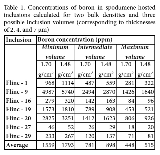 Display large image of Table 1
The sequence of diagenesis cements in sandstones of the Scotian Basin, Canada: a record of fluid circulation and thermal evolution
1. Department of Geology, Saint Mary’s University, Halifax, Nova Scotia B3H 3C3, Canada <gpiper@smu.ca>
2. Natural Resources Canada, Geological Survey of Canada (Atlantic), Bedford Institute of Oceanography, Dartmouth, Nova Scotia B2Y 4A2, Canada
117 Diagenetic minerals in Jurassic–Cretaceous sandstones of the Scotian Basin preserve a record of fluid geochemistry and thermal evolution of the basin. Diagenesis starts at the seabed, in coated grains that include chamosite, francolite, siderite, and pyrite. Early carbonate cement formed in transgressive or highstand firmgrounds. Where marine lowstands allowed circulation of meteoric groundwater, kaolinite, and minor titania cement formed. Silica cement is widespread as overgrowths on quartz framework grains, except where quartz grains have chlorite rims, which probably developed from coats of volcanic ash or soil. Widespread ferroan calcite cement postdates silica overgrowths.
118 Thick sandstones commonly have pervasive secondary porosity resulting from dissolution of framework quartz and feldspar and early cements. K-feldspar overgrowths on detrital K-feldspars and diagenetic replacement by albite are found from ~1.9–3.0 km depth, below which K-feldspar disappears through dissolution and/or replacement by ferroan calcite ± ankerite. Detrital plagioclase also alters to albite, which predates late ankerite cement. The widespread secondary porosity is partly filled by ankerite and by fibrous illite and chlorite. The last phase of diagenetic cementation includes barite, sphalerite, kutnohorite and a titania mineral.
119 Within this overall diagenetic paragenesis, five geochemical types of siderite are distinguished. Siderite (1), with negligible Mn and Mg substitution, is found in intraclasts in sandstones and is of brackish or meteoric water origin. Siderite (2) (moderate Mg and Ca substitution) occurs in coated grains, firmgrounds, and as concretions in shale. Siderite (3) (high Mg substitution, moderate Ca substitution) characterises a wide range of permeable sandstones and probably results from recrystallization during early generation of basinal fluids prior to hydrocarbon charge. Siderite (4) with moderate Mn substitution mostly postdates quartz overgrowths. Siderite (5) with high Mn substitution is youngest and fills late secondary porosity.
120 Fluid inclusion studies show that hydrocarbon charge postdates the main phase of silica and ferroan calcite cementation and may be synchronous with the widespread dissolution. The high salinity of some fluid inclusions, S isotope data and the presence of sphalerite all indicate an important role for brines from the Argo Formation evaporites. The complex thermal history of the basin results from (a) high regional Aptian–Albian heat flow manifested by late Aptian volcanism and (b) episodic Cretaceous–Paleogene up-dip migration of hot brines from the deeper parts of the basin. Changing fluid chemistry and thermal conditions had a strong influence on the diagenetic evolution of the basin and hence reservoir quality.
A mythical rock avalanche and tsunami in Greece: implications for Atlantic Canada
1. Natural Resources Canada, Geological Survey of Canada (Atlantic), Bedford Institute of Oceanography, Dartmouth, Nova Scotia B2Y 4A2, Canada <david.piper@canada.ca>
2. Department of Geology, Saint Mary’s University, Halifax, Nova Scotia B3H 3C3, Canada
3. Department of Earth and Environmental Sciences, Wesleyan University, Middletown, Connecticut 06457, USA
4. Faculty of Geology and Geoenvironment, University of Athens, Panepistimiopolis, Athens 15784, Greece
121 Dozens of surviving ceramics from ca. 500 BCE show scenes of the mythical battle between Poseidon, god of the sea, and the giant Polybotes, which occurred on the Greek island of Kos. Poseidon is shown killing his opponent with his trident, while carrying a huge rock that he had ripped off the island of Kos to bury Polybotes. Legend and ancient literary sources suggest that the event took place in southeastern Kos, near the then capital city of Astypalaia, which is located northwest of Zini mountain overlooking Kefalos Bay. The images on the ceramics represent a strong earthquake causing a voluminous coastal rock fall or rock avalanche. This disaster was a major event that reverberated throughout the ancient Greek world, triggering the imagination of its artists for several generations. Geological studies show a large, relatively recent, rock avalanche on the steep coast of Kefalos Bay on the southeast side of Zini mountain, with the scar extending over an area of ~0.3 km2. Tsunami sand deposits with reworked marsh foraminifera are found 9 m above sea level (asl) on northeastern Zini, less than 1 km from the archeological site of the old city of Astypalaia. Three kilometre distant is a wave-washed coastal platform with stranded boulders up to 6 m asl. Marine investigations offshore in Kefalos Bay show seafloor landslides and one or two turbidites younger than the ca. 1610 BCE Minoan ash horizon, but none can be unequivocally correlated with the rock avalanche event.
122 Similar rock avalanches on steep coastal cliffs in deep but restricted waters are a significant hazard on the coastlines of eastern Canada, especially in fiords. For example, sediment cores from Saguenay fiord provide a record of several Holocene earthquake-triggered rockfalls or rock avalanches and turbidity currents. A rock avalanche imaged by multibeam bathymetry in the St Lawrence Estuary resembles the deposits of the famous 1903 Frank slide in Alberta. There is a risk of similar events in coastal fiords of Newfoundland, Labrador and Baffin Island. We can only speculate on how such an event might influence Canadian art and culture.
The Rockhound of York Redoubt: teaching old dogs new outreach tricks*
1. Geological Survey of Canada (Atlantic), Natural Resources Canada, Bedford Institute of Oceanography, Dartmouth, Nova Scotia B2Y 4A2, Canada <Patrick.potter@canada.ca>
2. Storytellers Circle of Halifax, 44 Ellenvale Avenue, Dartmouth, Nova Scotia B2W 2W5, Canada
123 The AGS Video Committee has been active since the mid-1980s, helping to instruct, entertain, and enlighten geoscientists and interested lay people on all manner of topics related to Atlantic Canada geology. However despite past successes (e.g., Halifax Harbour video), recent technological and social changes in the way people find and digest information, dictate that the days of AGS producing high cost full-length productions on DVD have passed. The shifting media landscape became an opportunity to reach new audiences more easily, and so, rather than go extinct, the AGS Video Committee chose to focus on bite-sized, vignettes on geological themes and sites. One pilot for this new direction is the geology story at York Redoubt National Historic Site. This accessible and attractive location has been visited by Dalhousie field camp students and by teachers on EdGEO field trips, providing an opportunity for earth science newcomers to explore and map local bedrock geology in the context of the region’s cultural and military history. We wanted to tell this story succinctly, in an inviting and exciting way, and to educate viewers without being dry and stodgy. A committee was formed of members with various backgrounds: geology, video production, outreach, and, storytelling. Discussions centred on how to tell the geology story in the background of a human story with interesting characters. Enter Dusty, the Rockhound of York Redoubt; the perfect foil to the tiresome know-it-all geologist who persists in telling you what you’re looking at. This approach will hopefully help to make the topic more accessible and entertaining to the intended audience. With Dusty as the lead actor, a storyboard was assembled. Once on location, other challenges were faced. We share these challenges, and the satisfaction of producing a vignette, hoping to spur on others to produce their own. Most of all, we hope to inspire the young tech-savvy smartphone generation to create vignettes on topics and sites that are meaningful to them; and probably do it in one take!
Grain size analysis of sediments from the surrounding cliffs of the Minas Basin, Nova Scotia, Canada
Department of Earth Sciences, Dalhousie University, Halifax, Nova Scotia B3H 4J1, Canada <monique.johanna.ruhl@gmail.com>
124 The Minas Basin of the Bay of Fundy in Nova Scotia is a dynamic macro-tidal system providing great potential for harnessing tidal power. Tidal power extraction would affect flow speeds, which in turn may alter sediment size on the seabed. Because sediment size is a fundamental determinant of benthic community structure, extraction of energy could affect habitats in the Basin. A previous study indicated that the sediment distribution within the Bay of Fundy is not in equilibrium with the maximum tidal bed shear stress. Based on comparison of stresses predicted by a 3-D ocean circulation model and measured sediment sizes, the study showed that the competent mean grain sizes within the Bay of Fundy are generally coarser than observed mean grain sizes; suggesting that bed shear stress is not the dominant determinant of sediment texture in the Bay of Fundy. My work will examine an alternate hypothesis that seabed sediment texture of the Minas Basin is determined by the texture of sediments entering the basin through erosion of the surrounding cliffs, and not by local seabed stresses exerted by tidal currents. The objectives of this study are to (1) determine the grain size distribution of eroding cliffs based on rock type and (2) compare the mean grain sizes to those found within the Basin. To test this hypothesis, samples of bedrock, unconsolidated beach sediments, and till (N = 54, 29, and 7, respectively) were collected from four locations around the Minas Basin and compared to seabed samples collected from the Basin (N = 161) by others. If the grain sizes of eroding cliffs and tills are similar to the grain sizes in the Basin, then it is unlikely that changes in energy caused by in-stream tidal turbines would have a large effect on the size of sediments in the Basin.
Teaching and learning geoscience in the 21st century
Department of Earth Sciences, Dalhousie University, Halifax, Nova Scotia B3H 4R2, Canada <amryan@dal.ca>
125 With the rapid expansion of our disciplinary knowledge, together with technologies available at the touch of a button and our growing understanding of how learning happens, teaching geoscience begs a new set of approaches and tools to use in our teaching. What does cognitive science tell us about how students develop understanding? How can we effectively incorporate technologies to help student learning? How do we challenge students to think critically, consider assumptions, and evaluate all the evidence, while also developing attributes such as team work, effective communication, and problem-solving, that will stand them in the world beyond their undergraduate years? This session aims to look at strategies consistent with current best-practices for engaging students in critical thinking and effective learning in the classroom and beyond.
Comparative rates of weathering on ilmenite in titanium deposit from Kahnuj, South of Iran
1. Department of Earth Sciences, Dalhousie University, Halifax, Nova Scotia, B3H 4R2, Canada
2. Department of Earth Sciences, Shiraz University, Shiraz, 7146713565, Iran <Monir@dal.ca>
126 The titanium resources in Iran can be classified as mafic intrusions and placer deposits. Kahnuj deposit is located in Kahnuj ophiolite, 330 km south of Kerman, Iran. The deposit is the largest titanium deposit in Iran which presents in gabbroic rocks of the Kahnuj ophiolite (Late Cretaceous.) and alluvial placer ores of Darreh-Gaz valley (Quaternary). The ophiolite became a source of fragmental material for the ilmenite placer formation and was weathered and being transported by river streams accumulated as a cone of dejection in the valley. The placer deposit occurs in high level terrace deposits (Qtla) and recent stream sediments (Qt2). The purpose of this work is to investigate the ilmenite changes in the placer deposit and compare their properties with that ilmenite from the source rocks during weathering. The ilmenite concentrate of the fresh and weathered source rock (ferrogabbros and ilmenite gabbros) and the sediment samples (Qtla and Qt2) were studied for the purpose. An investigation of textural relations of the ilmenite in the Kahnuj deposit was carried out in conjunction with quantitative mineralogical studies like XRD, SEM-EDX and TGA and magnetic susceptibility measurements. Ore microscopic investigation reveals that intensity and mode of alteration in the ilmenite grains was different in our samples. The shape of ilmenite grains ranges from prismatic-subhedral to anhedral and irregular depending on the distance from the bedrock source and energy in the depositional environment. The degree of weathering of the detrital ilmenite in the study area affected the grain size, surfaces morphology, magnetic and thermal properties. The progressive weathering of the detrital ilmenite leads to an increasing development of intra-grain fractures and to the extensive replacement of secondary products such as rutile, pseudorutile, and sphene. Despite undergone limited alteration of ilmenite in the parental rock, they differ from the quantitative and qualitative properties of the ilmenite grains that enter sedimentary drainage systems. The Kahnuj deposit is a unique natural laboratory allowing for studying changes in ilmenite properties during fluvial transport.
Fluorine-rich ferroan calcite and diagenetic zircon in the Newburn H-23 well, Scotian Basin, Canada: indicators of unusual diagenetic processes*
Department of Geology, Saint Mary’s University, Halifax, Nova Scotia B3H 3C3, Canada <csangster16@gmail.com>
127 Diagenetic minerals preserve an important record of fluid flow in the development of hydrocarbon basins. Previous studies in the Scotian Basin have shown the importance of hot brines transporting hydrocarbons and precipitating unusual suite of late diagenetic minerals. The Newburn H-23 on the Scotian Slope has two diagenetic mineral occurrences which have not been documented elsewhere in the Scotian Basin: fluorine-rich ferroan calcite (F-Fe-calcite) and diagenetic zircon.
128 Fe-calcite contains fluorine >1 wt% in several samples. Fluoride (F-) in diagenetic environments has been accredited to a variety of processes including the advection of hydrothermal fluids through sediments, Al-silicate reactions, degradation of sea grass, and carbonate mineral diagenesis. Fluids with low pH and F concentrations >10 ppm are required. Fluoride ions have been shown to be removed from solution in these environments as a result of: (a) adsorption onto the surface of calcite and (b) precipitation of fluorite on the surface of the calcite. The F-Fe-calcite in this study is most common in the deepest studied samples at 5.4 km, late in their paragenesis and is associated with formation of secondary porosity, fibrous chlorite lining secondary porosity and late siderite. Grains of F-Fe-calcite also shows patchy fluorite precipitation. These observations suggest that the depth probably influenced either a) the availability of fluoride or the mechanism of association of fluoride with Fe-calcite, or b) changes in the composition of circulating basinal fluids.
129 Zircon grains in this well display features which suggest that they are not purely detrital, including crystal outlines which are straight adjacent to pores, partially lobate, appearing to fill porosity, and cross cutting detrital and other diagenetic grains. Diagenetic zircon has been documented to form new crystals at temperatures ~270°C and outgrowths around detrital zircon at ~250°C, with zirconium mobilized during the alteration of detrital zircons under low-grade metamorphic conditions. The presence of diagenetic sphalerite and the documented mid Cretaceous thermal event in the Scotian Basin indicate conditions which could have been suitable for the formation of diagenetic zircon in this well. The euhedral form of these grains thus may suggest (a) a large supply of complexing elements including fluorine in parent circulating solutions which formed the zircon, (b) a large supply of zirconium from altered and dissolved metamict detrital zircon, (c) temperatures at least of the order of ~250°C which persisted long enough for <200 µm euhedral crystals to form.
Characterizing the mineral domains of Li-(Rb-Cs) enrichment at the East Kemptville Sn-(Cu-Zn-Ag) deposit, southwestern Nova Scotia, Canada
1. Department of Geology, Saint Mary’s University, Halifax, Nova Scotia B3H 3C3, Canada <cathysedge@gmail.com>
2. Avalon Rare Metals Inc., Toronto, Ontario M5H 3P5, Canada
3. Department of Earth Sciences, Laurentian University, Sudbury, Ontario P3E 2C6, Canada
130 The ca. 380 Ma composite South Mountain Batholith contains 11 plutonic centers, including the Davis Lake Pluton that hosts the East Kemptville Sn-Cu-Zn-Ag deposit. Whereas this deposit was previously mined (1985–1992) primarily for Sn and this remains the main commodity of interest in current resource evaluations, other elements of interest and having prospective by-product credits, in addition to formerly extracted Cu-Zn-Ag, include the group I alkalis Li, Rb and Cs. However, where these latter elements reside in terms of their mineralogical sites, lithological controls (i.e., host rocks of residence), distribution, and relationship to Sn mineralization are not constrained. This study describes the nature of this Li-Rb-Cs mineralization as determined using a combination of optical petrography, Raman spectroscopy, scanning electron microscopy, and laser ablation ICP-MS.
131 The host metasedimentary rocks, contact zone, and topaz-muscovite leucogranite intrusion all contain Li-rich minerals which include zinnwaldite, phlogopite, muscovitetrilithionite, and tourmaline. A bulk rock control of mica chemistry is reflected by ternary element plots and a Rb-Sn-Li diagram is the best discriminate among different Li domains by rock type when used for mafic micas, but less so for muscovite-type micas. In comparison, a ternary plot of Nb-Li-Ta distinguishes among rock types for both mafic micas and muscovite-type micas. In terms of mica chemistry, phlogopite grains >600 μm typically contain >6000 ppm Li and are found within the granite, whereas grains in the metasedimentary rocks are smaller but more abundant. Overall granite-hosted phlogopite appears to be the main Li-Rb-Cs carrier in contrast to the metasedimentary rocks where muscovite-trilithionite contributes the largest portion of Li-Rb-Cs. Enrichment in Li at the contact zone may related to infiltration of wall-rock derived fluids from the host metasedimentary rocks which facilitated the growth of new mica in this zone. Overall there is a correlation among Rb-Cs-Li, whereas there is a lack of correlation of Sn with Li-Rb-Cs. Instead, Sn concentrations are higher for granite-hosted mica with Li-Rb-Cs mainly higher in the metasedimentary rock-hosted mica.
Preliminary evaluation of the compositional sedimentary variation of the Jurassic Iroquois and Mohican formations of the Scotian Basin, Nova Scotia, Canada
1. Basin and Reservoir Lab, Department of Earth Sciences, Dalhousie University, PO Box 15000, Halifax, Nova Scotia B3H 4J1, Canada <sedore.p@dal.ca>
2. Department of Geosciences, University of Texas at Dallas, ROC 21, 800 West Campbell Road Richardson, Texas 75080, USA
132 The compositional sedimentary variation of the Jurassic Iroquois and Mohican formations of the Scotian Basin (Canada) was evaluated in 9 wells (531 cutting samples) using a Thermo Scientific Niton xl3t gold+ XRF analyser and the SandClass geochemical compositional classification based in major elements. A graphical projection of the SiO2/Al2O3 and Fe2O3/K2O ratios with respect to depth, for multiple wells, can be used as a tool to determine the lateral continuity of lithology sand any better define any potential source rocks.
133 Our data shows that these two formations present a large inter and intra unit compositional variation, even between closely related wells. It is clear that these units represent very dynamic depositional systems with apparent lateral facies variability. In addition, the integration of our data with those previously published will enable refinement of the currently accepted stratigraphic frameworks and/or the definition of new paleo-environmental models, through finer tuning of the sedimentological, biological and hydro-atmospheric conditions correlative of sedimentation for the referred time interval.
134 We wish to acknowledge the industry and government partners of the Basin and Reservoir Lab and the Source Rock and Geochemistry of the Central Atlantic Margins consortium for their kind support.
Soil geochemistry of urban soils in Fredericton, New Brunswick, Canada
Department of Earth Sciences, University of New Brunswick, Fredericton, New Brunswick E3B 5A3, Canada <d.senechal@unb.ca>
135 The City of Fredericton, New Brunswick, overlies an aquifer that supplies potable water to ~95% of the city residents. The supply aquifer is confined by a discontinuous clay-silt aquitard which underlies fluvial/floodplain deposits situated between the Saint John River and higher terrain to the west. The aquitard contains erosion scours or ‘windows’, that can serve as pathways allowing surface water into the aquifer.
136 A total of 101 locations were sampled as part of a soil geochemical survey of the city of Fredericton, with a focus on the geochemical content of surface sediments in the areas of known and suspected ‘windows’. An ‘A’ sample was collected at a depth of ~10 centimetres, primarily in the A soil horizon and, where possible, a ‘B’ sample was collected at a depth of ~30 cm, primarily in the B - C soil horizons. Sixty seven samples were collected in the downtown urban centre consisting of reworked and fluvial floodplain sediments. Samples of till were collected from areas of higher elevation at locations undisturbed by anthropogenic activity. All organic fragments were removed during sampling. Sample splits of <63 microns were analyzed by INAA or TD-ICP in order to determine concentrations for 50 elements.
137 Topography and elemental mobility are interpreted to have played a major role in the dispersion of elements. The till ‘B’ samples often displayed higher elemental concentrations than the ‘A’ samples, interpreted as due to weathering and element mobility. Samples from the downtown area demonstrated much higher elemental concentrations in the ‘A’ samples in comparison to the underlying ‘B’ samples. The concentration of eight elements including, As, Ba, Cr, Cu, Ni, Pb, V, and Zn were found to surpass the Canadian Council of Ministers of the Environment (CCME) soil content guidelines for samples collected in the downtown area. These concentrations are attributed to anthropological contributions at ground surface after two hundred years of occupation in the city. The ‘A’ samples for one specific downtown area exhibited anomalous concentrations of all 8 elements and the exact cause remains to be identified.
From Gondwana to Pangea: genesis of West Avalonian silicic igneous rocks from Neoproterozoic to Late Ordovician by repeated partial melting of the lower crust
1. Department of Earth Sciences, National Taiwan Normal University, 88 Tingzhou Road Section 4, Taipei, 11677, Taiwan <jgshelln@ntnu.edu.tw>
2. Department of Earth Sciences, St. Francis Xavier University, Antigonish, Nova Scotia B2G 2W5, Canada
138 Avalonia is a terrane that originated along the Gondwanan margin in the Neoproterozoic but was transferred to Laurussia in the Paleozoic. Its many episodes of igneous activity include ensialic arc-related magmatism along the Gondwanan margin in the late Neoproterozoic, translation along that margin in the Cambrian and separation from Gondwana in the Early Ordovician. The application of MELTS modeling demonstrates that some of the Neoproterozoic to Middle Ordovician silicic rocks of the West Avalonia in the Antigonish Highlands, Nova Scotia, can be derived by equilibrium partial melting of lower crustal lithologies, as represented by exposed mafic granulites and orthogneiss, at a pressure of 0.8 GPa and fO2 >FMQ 0. The chief difference between the model conditions is the water content. The Neoproterozoic rocks can be derived by ~35% partial melting of a hydrous source (i.e., H2O = 3 wt.%) whereas the Cambrian rocks can be derived by ~15% melting of comparatively dry source (H2O = 0.5 wt%). Similarly, the Middle Ordovician rocks can be generated by high amounts of melting (i.e., ~50%) of a hydrous source (i.e., H2O = 5 wt.%) whereas the Late Ordovician rocks require a relatively dry source. The difference in melting conditions is consistent with their tectonic setting as the Neoproterozoic and Middle Ordovician rocks were generated at an arc setting whereas the Cambrian and Middle Ordovician rocks are characteristic of rocks from an extensional setting. The results show that the same crust underlay the Antigonish Highlands from its origin along the Gondwanan margin, to its rift and drift towards Laurussia.
Mud aggregates within a fine-grained meandering channel in the early Permian Clear Fork Formation of north-central Texas, USA
Department of Earth Sciences, Dalhousie University, Halifax, Nova Scotia B3H 4R2, Canada <sharane.simon@dal.ca>
139 The early Permian Clear Fork Formation of north-central Texas is a 350–365 m thick redbed deposit on the Eastern Shelf of the Midland Basin. Within this formation, fine-grained meandering systems are the dominant fluvial style, exposed in exhumed surfaces and cliff faces. At one particular site (North Soap-Creek Quadrangle), the lateral-accretion deposits define a complete point bar and are mainly composed of well-preserved mud aggregates, which provide a rare opportunity to evaluate the origin, the depositional environment and the conditions responsible for their preservation.
140 At Don’s Dump, the exhumed lateral-accretion deposits are composed of thick intervals of massive to weakly stratified mudstone interbedded with thin layers of ripple cross-laminated sandstone. The cemented sandstones preserve the exhumed topography from erosion and contain a range of sedimentological features including ridge-andfurrow structures, climbing and symmetrical ripples, rill casts, elliptical scours, root traces, burrows, and Diplichnites gouldi trackways. In contrast, the massive mudstones only contain root traces, slickensides, and redoximorphic spots. The meandering channel had a radius of curvature of 140 m, an estimated bankfull width and depth of 57 m and 2.2 m, and discharge ranges from 64–127 m3s-1. The rhythmic nature of the accretion deposits reflects the source area and the size of flooding events: mudstones were locally derived during low-magnitude events, whereas the sandstones were brought into the basin during high-magnitude floods.
141 Petrographic analysis revealed that the mudstones are composed of sutured reddish-brown and grey mud aggregates with a minor component of quartz, feldspar, dolomite, and ferruginous grains. The mud aggregates comprise illite, chlorite, kaolinite and complex mixed clays with silt-sized mineral grains. Due to compaction, the aggregates are elongate and the major axes are oriented quasi-parallel to bedding. Compared to associated quartz grains, the mud aggregates are twice the size and are buffered by mineral grains, hematite-rich clay rims and matrix.
142 The aggregates are interpreted as pedogenic in origin, formed during cycles of wetting and drying of floodplain soils or in cutbanks that contained swelling clays under hot, seasonal climates. Washed into the channels, they behaved as bedload and the difference in grain size from quartz reflects their lower density. Even though mud aggregates typically lose their texture during burial below 2 m, the excellent preservation in the Clear Fork Formation is attributed to rapid burial of the channel sediment which impeded pedogenic modification, the shallow burial of the formation, and the stabilising effect of hematite.
That’s how those got there! Microbasins and other unusual soft-sediment deformation structures in the Horton Group, Windsor-Kennetcook subbasin, Nova Scotia, Canada
Department of Earth & Atmospheric Sciences, University of Alberta, ESB 1-26, Edmonton, Alberta T6G 2E3, Canada <mesnyder@ualberta.ca>
143 The Mississippian Horton Group, exposed in the Windsor-Kennetcook subbasin of the Maritimes Basin, shows spectacular soft-sediment deformation structures. Because of their accessibility, these structures are much visited by student and other field trips. Soft-sediment deformation structures provide information on the early deformation history of these sedimentary rocks, as they formed when primary stratification was in a weakened state due to liquidization of sediment. The exposed soft-sediment deformation structures include well-known features like load structures and intraformational breccia, and less common features like clastic dykes, sedimentary boudins, and bulb structures (which resemble load casts but protrude upwards from the top surfaces of sandstone and siltstone beds). A unique set of soft-sediment deformation structures, here termed microbasins, are well known to the geological community but previously not well understood. These are elliptical bodies of sand and silt that show a strong preferred orientation parallel to the clastic dykes. Internal lamination shows localized discordances around the margins of the structures, and therefore records differential subsidence and erosion during their development. Some of the structures show convex-up laminae, formed where the underlying mudstone layer is pinched out. Microbasins are geometrically and kinematically similar to minibasins associated with salt tectonics, but are approximately three orders of magnitude smaller. They are interpreted to result from soft-sediment deformation that took place during sedimentation.
144 Soft-sediment deformation structures in the Horton Group can be divided into two categories: those that clearly initiated close to the sediment-water interface, like microbasins and sedimentary dykes, and those that probably formed within the sediment pile, like soft-sediment boudins and bulb structures. The triggering mechanism for all the soft-sediment deformation structures was likely a combination of seismicity and overpressured conditions. A strong preferred orientation of these soft-sediment deformation structures oriented NWSE is attributed to dextral strike-slip on the E-W Minas Fault Zone to the north and associated faults. Seismicity associated with movement along these faults could have induced liquidization of sediment.
Early–Middle Jurassic depositional environment variability in Well Mohican I-100 Cores 7 and 8, Scotian Basin, Canada
Basin and Reservoir Laboratory, Department of Earth Sciences, Room 3060, Life Science Center, Dalhousie University, Halifax, Nova Scotia B3H 4R2, Canada <Maya.Soukup@Dal.Ca>
145 In this study, we have observed, recorded, and interpreted the microfacies of 15 thin sections from the cores 7 and 8 of the well Mohican I-100 (offshore Nova Scotia). This work was conducted to better understand the local variations in the depositional environments within the broader context of the Scotian Basin during the Early–Middle Jurassic age. We also aim to investigate the source rock and/or reservoir potential of this carbonate (dolomitic) succession. Overall, the microfacies analyses of these samples highlight the dynamic nature of the observed transitional to marine depositional environments, ranging from coastal plain to marginal marine; tempestites and evaporitic facies are identified as well. The variations in the depositional environments can provide us clues to the regional changes within the basin. SEM work was successful in identifying framboids, which will be used for further analyses. Analysis was completed through graphic logging, SEM work, and microscope work. Ongoing research is focused on studying palynofacies, organic matter content, mineralogy, and sequence stratigraphy.
Recent investigations at the East Kemptville Sn deposit: identifying lithologies, understanding hydrothermal alteration, constraining controls on mineralization, and estimating bulk densities using lithogeochemical data
1. Department of Earth and Environmental Science, Acadia University, Wolfville, Nova Scotia B4P 2R6, Canada <cliff.stanley@acadiau.ca>
2. Department of Earth and Environmental Sciences, University of Windsor, 401 Sunset Ave., Windsor, Ontario N9B 3P4, Canada
146 Recent diamond drilling at the East Kemptville Sn deposit, Yarmouth County, Nova Scotia, by Avalon Rare Metals Inc. has provided lithogeochemical data that reveal new information about the host lithologies (three recognizably different granite phases), hydrothermal alteration (two topaz-precipitation reactions), and mineral zoning (sphalerite and chalcopyrite mineralization is largely restricted to topaz-altered host rocks) within the deposit. Lithogeochemical data have also been used to constrain/ confirm the bulk feldspar (Or20), muscovite (Fe-phengite50), and topaz (F-topaz25) compositions, and balance three reactions responsible for muscovite and topaz alteration. ‘Change of basis’ calculations that convert element concentrations into mineral concentrations (equivalently describing rock compositions) provide new mineralogical variables that more directly describe zoning within the deposit. These mineralogical concentrations can also be used to estimate physical and chemical parameters describing the rocks. For example, mineral modes have been regressed against conventionally measured rock densities in training data subsets to produce linear functions that estimate rock densities. These regression models have also been used to estimate densities in other validation data subsets. Results demonstrate that the regression models provide adequate (accurate, precise, and representative) density estimates of the rocks. Because such lithogeochemically derived density estimates compare favorably with measured density estimates, if lithogeochemical data are collected during mineral exploration, adequate density measurements can be calculated post facto from these element concentrations, precluding the need to measure rock densities in feasibility studies and saving substantial costs.
Old and new gravity reference stations in St. John’s, Newfoundland, Canada
Department of Earth Sciences, Memorial University of Newfoundland, St. John’s, Newfoundland and Labrador A1B 3X5, Canada <j.thistle@mun.ca>
147 The Canadian Gravity Standardized Network (CGSN) is a series of absolute gravity reference stations maintained by Natural Resources Canada. Incorporating one of these stations into a gravity survey allows relative gravity measurements to be converted to absolute gravity. On the island of Newfoundland there are 2 primary stations and 82 secondary stations which are all tied to a primary station. In the St. John’s area there are 18 stations located around the harbor. The first part of this study was conducted to determine which of the 18 stations are still accessible. It turns out that all of the stations are either built over, on private property, or behind security fences. The second part of this study was to set up new replacement gravity stations for the convenience of researchers. Three locations were chosen: outside the Johnson Geo Center on Signal Hill; indoors in the lower level of the Johnson Geo Centre; and next to the statue of Terry Fox outside of the St. John’s Port Authority building. These stations were chosen because they are in flat, stable areas sheltered from the wind, they are easy to find and access, and they are not likely to be built over or changed in the foreseeable future. These stations were then tied into a fourth station located in the basement of the Earth Sciences building at Memorial University. This fourth station was in turn tied into the only primary station in the area, which is inconveniently located in a locked vault in the basement of the Science building at Memorial University, and therefore difficult to access.
What small earth science institutions can do for education: an example from the Quartermain Earth Science Centre
Quartermain Earth Science Centre, Department of Earth Sciences, University of New Brunswick, P.O. Box 4400, Fredericton, New Brunswick E3B 5A3, Canada www.QuartermainEarthScienceCentre.com <ann.timmermans@unb.ca>
148 Critical decisions that rely on our understanding of science are made on a regular basis; how we manage our energy and mineral resources, handle climate change, invest in alternative fuels, sustain access to clean water, and repair our decaying infrastructure. To preserve our way of life and survival, Earth Science literacy is an urgent and important issue. To accomplish this involves tough challenges for (1) motivated educators and the public searching for information, as well as (2) many time-strapped Earth Scientists seeking a way to provide quality, meaningful broader information to schools (K-12) and general public. Who will clearly explain these issues to the public and to policy-makers?
149 Since its doors opened in June 2011, the Quartermain Earth Science Centre, (QESC) has recognized this vital responsibility with initiatives that include inquiry-based hands-on geological activities, public lectures, geo-hikes, and collaborative efforts with other science educators and institutions. Joining social media with its website (QuartermainEarthScienceCentre.com), Facebook, and Twitter accounts has proven essential to awareness on programs and events. The QESC offers tours as well as educational activities at the museum or remotely.
150 For a small institution with one curator, the museum benefits from public and private funding, donations and community support. Graduate students, volunteers, co-op and work-study programs allow the QESC to function with minimum staff while providing quality outreach programs. The curator manages administration and scheduling, allowing the professionals and graduate students to focus on connecting with the public.
151 Collaboration with other science educators, events and institutions, and individual professionals has been vital to increasing outreach while keeping expenses low. For example, the QESC provides programs for travelling science fairs, camps and other groups. Science East invited QESC to their popular events such as Illuminate (a program to promote STEM career opportunities). Education and outreach groups such as Let’s Talk Science and Worlds Unbound by developing and implementing Earth Science activities. Teacher workshops and collaboration with UNB’s Faculty of Education has resulted in developing Teacher Science Kits on Minerals and Rocks in support of the grade-4 curriculum.
152 QESC recognizes that small museums are a valued community resource, providing opportunities for students and the public at large. If people and institutions have the will and accept their responsibilities, then we can turn the tide for scientific literacy. Time is not our ally, and action is needed now.
Nitrogen and phosphorus availability in surface and ground water in the Cumberland Marsh Region, Canada: impacts on productivity in constructed wetlands
1. Acadia University, Earth and Environmental Science, Wolfville, Nova Scotia B4P 2R6, Canada <114013t@acadiau.ca>
2. Acadia University, Biology, Wolfville, Nova Scotia B4P 2R6, Canada
3. Ducks Unlimited Canada, Amherst, Nova Scotia B4H 3Y4, Canada
4. Department of Natural Resources, Halifax, Nova Scotia B3J 2T9, Canada
153 The Cumberland Marsh Region (CMR), located on the coast of the Bay of Fundy, is a major feeding ground for waterfowl and contains significant coastal wetland systems. At this site there is concern over the mobility and toxicity of metals in lake sediments, and management practices that may influence these processes. As well constructed wetlands may support significant populations of migratory waterfowl, however wetland senescence appears to be a limiting factor in the viability of this habitat. This study focuses on evaluating nitrogen (N) and phosphorous (P) in both surface and ground water, and the effect of these nutrients on wetland productivity. Research was conducted near Aulac, New Brunswick, and included collection and analyses of surface and ground water samples, identification of natural and anthropogenic nutrient sources, and consideration of the influences of regional geology and geomorphology. Water analyses were carried out weekly over a 3-month period on ten constructed freshwater wetlands, one altered freshwater wetland and three ground water sites. Preliminary results indicate that the impact of regional N and P sources on the sampled wetland sites is relatively low, and P loading is primarily autochthonous. These observations are supported by low N readings (<3 mg/L) at all sites with little seasonal variation, and higher (eutrophic) P levels that fluctuate without external input (40−300 µg/L) most notably in newly constructed wetlands. Although land use may not be an important contributor to N levels in surface water, a spike in ground water levels suggests that significant anthropogenic sources exist. Conductivity was variable, ranging from 805 µS/cm to detection limit, suggesting that allochthonous sources from local geological deposits and/or seawater may contribute other nutrients. Future research will investigate sediment archives in old constructed wetlands using the paleolimnological method to assess the temporal and spatial variability of wetland productivity in the CMR. Wetland productivity proxies and water chemistry will be analyzed to better understand factors that govern wetland senescence.
Geochronology and tectonic interpretation of the Nepewassi Domain, Central Gneiss Belt, Grenville Province, Ontario, Canada
1. Department of Earth Sciences, Dalhousie University, Halifax Nova Scotia B3H 4R2, Canada <sm925110@dal.ca>
2. Norges Geologiske Undersøkesle, 7491 Trondheim, Norway
154 The Nepewassi domain is a parautochthonous unit within the Central Gneiss Belt of the Grenville Province. The aim of this study is to characterize the rocks in the Nepewassi domain, with the intention of testing the hypothesis that the parautochthon belt is the remnant of an inverted Paleoproterozoic passive margin. Igneous and detrital zircon U-Pb geochronology was completed using laser ablation – inductively coupled plasma – mass spectrometry at NGU in Trondheim. Tonalitic and granodioritic gneisses returned ages of 2673.2 ± 14 Ma and 2685.8 ± 4.8 Ma, similar to ages previously determined in the area, and nearby cratonic foreland. Detrital zircons in four quartzite samples were analyzed to determine the provenance of the sedimentary protolith. Three samples from a package of various metasupracrustal rocks lie along-strike within an east-dipping shear zone. The fourth quartzite sample is located a few kilometres across strike, at a higher structural level. All four samples have a detrital population peak at ca. 2.7 Ga, and two have a second peak at ca. 1.75 Ga. Zircon morphology suggests that, in a quartzite within the shear zone, the younger peak represents metamorphic rims; however in the structurally overlying quartzite, the younger peak represents a second detrital population. Metamorphic monazite from a metapelite, located within the same shear zone as three of the quartzite samples, was analyzed in situ using U-Th-Pb geochronology by electron probe at Dalhousie. The data show a large Grenvillian peak at ca. 990 Ma and a smaller, asymmetrical Paleoproterozoic peak with a dominant peak at ca. 1740 Ma and a subsidiary peak at ca. 1840 Ma. The combination of igneous, detrital, and metamorphic ages provides significant insight into the tectonic history of the rocks of the Nepewassi domain. We can now infer that Laurentian (Superior Province) cratonic basement rocks were the source of detritus in the metasedimentary rocks within the Nepewassi domain. Metamorphic and intrusive rocks formed ca. 1750 Ma may have been an additional source of sediment for the structurally higher and younger quartzite. The ca. 2.7 Ga detrital zircon population in the Nepewassi quartzite samples closely resembles metasedimentary formations in the Huronian Supergroup, which were deposited in a passive margin, on the southern edge of the Laurentian craton. Thus, these data support the hypothesis that sediments in the Nepewassi domain were also deposited on the edge of the Laurentian craton in a passive margin that was then inverted around or before ca. 1750 Ma during the Yavapai orogeny.
Impacts of land cover change on evapotranspiration: a synthesis of forest-grassland studies
Department of Earth Sciences, Dalhousie University, Halifax, Nova Scotia B3H 4R2, Canada <robvarcoe@dal.ca>
155 Evapotranspiration (ET) plays a vital role in the Earth’s water cycle, supplying ~62% of continental precipitation, and influencing local, regional and global climates. ET also determines the amount of water input to a surface, driving rates of groundwater percolation, surface runoff and catchment outflow, and therefore influencing the water available for ecosystem and human consumption. Because ET rates depend on land cover type, anthropogenic changes such as deforestation, agriculture and urbanization have significant effects on ET.
156 The conversion of forests to grasslands (FGC) is a widespread land cover change and is also among the most commonly studied changes with respect to its impact on ET; such research employs a variety of experimental approaches (budyko, paired catchment, GCM, etc.) and measurement methods (water balance, eddy covariance, remote sensing, etc.). Until recently, this literature has been nearly unanimous in its conclusion that rates of ET will decrease when a forest is converted to grassland. However, this consensus has recently been questioned; using global Fluxnet eddy covariance data, where it was previously determined the grasslands have a 9% greater evaporative index than forests. In addition, it was previously concluded that in tropical regions that are not water-stressed, grasslands have equal or higher potential ET then forests. My research will provide an analysis of the literature studying the impacts of FGC on ET rates in an attempt to provide a better understanding of the forest – grassland ET paradigm.
157 I have assembled a database of 70 studies comparing forest and grassland ET under conditions controlled for climatic and environmental influences. Data was acquired through a literature search where selection criteria limited data to paired catchment, adjacent plots or before and after conversion experiments. Using this data I will determine if forest ET is indeed higher than grassland ET under these controlled conditions. I will then analyse the ET measurement methods to attempt to determine bias in any individual technique. Finally, I will use a previously compiled global ET dataset to determine in what, if any cases, grasslands may have higher ET than forests.
Petroleum systems and risk elements of the offshore Atlantic Canada
Basin and Reservoir Lab, Department of Earth Sciences, Dalhousie University, Halifax, Nova Scotia B3H 4R2, Canada <grant.wach@dal.ca>
158 Source rock is a fundamental component of petroleum systems; coupled with reservoir distribution they are the two key risk elements in many basins offshore Eastern Canada. Significant issues in recent hydrocarbon exploration on this margin were accurate definition of the main source rock intervals and detection of reservoir rock. Existing models of deepwater sedimentation have underestimated the links between shelf and slope sedimentation, the roles of sea level, salt tectonism, and canyon formation, as controls on sediment transport pathways. Mass failure and along-slope sediment transport are also significant processes in passive continental margin development. The consequence of these sedimentary processes is the inherent complexities of shelf to slope sedimentation patterns and movement of potential reservoir rock to greater depths than previously anticipated.
159 Hydrocarbon exploration offshore Nova Scotia began in 1959, but the Scotian Basin remains unexplored with very few exploration wells (127 of 207), most concentrated in the Sable Subbasin. Exploration and production of gas and condensate focused on the (1) rollover anticlinal plays of the Mesozoic Sable delta, and (2) the carbonate platform. But the source and timing of hydrocarbon generation and migration pathways of these discrete petroleum systems are not fully understood. In comparison, the petroleum systems of the Newfoundland offshore margin are better understood with over 1.3 billion barrels produced from one major source rock interval, the Kimmeridgian Egret Mb. of the Rankin Fm. However, the extensive Jurassic source rocks cropping out on the Western European and African conjugate margins suggest that exploration for hydrocarbons can test alternative (and new) play concepts, improving chances of success.
160 The Basin and Reservoir Research Lab is a dedicated facility for petroleum geoscience research and training within the Department of Earth Sciences at Dalhousie University. Ongoing research has translation benefits to the offshore oil and gas sector through new insights developed from our studies of the petroleum systems, offshore eastern Canada.
Preliminary paleomagnetic assessment of the Cambrian Port au Port Group, Port au Port Peninsula, Newfoundland, Canada
1. Department of Earth Sciences, University of Western Ontario, London, Ontario N6A 3K7, Canada <hwarsame@uwo.ca>
2. Department of Earth and Atmospheric Sciences, University of Alberta, Edmonton, Alberta, T6G 2E3, Canada
161 The Cambrian Port au Port Group is a 500 m-thick unit of carbonate and clastic rocks exposed in the Port au Port Peninsula, NL. The group is associated with the passive margin phase of the Laurentian margin following breakup of the supercontinent Rodinia. Paleomagnetic assessment of natural magnetic remanence in carbonate and red siltstone specimens aimed to reveal ancient directions, allowing a paleoposition of this region during deposition to be calculated. Several previous paleomagnetic studies from the Port au Port Peninsula reported results for the overlying Early Ordovician St George and Table Head Groups, finding that the ancient magnetic directions were likely overprints acquired during the Alleghenian and Taconic orogenies, although two primary Ordovician paleomagnetic results are still used in syntheses of Laurentia paleogeography.
162 Preliminary paleomagnetic results of the Port au Port Group have revealed similar findings as previous studies on the peninsula. The group was sampled in 20 sites, with an additional site for the underlying Hawke Bay Formation. The 21 sites produced 198 specimens, with 15 of those sites producing interpretable results. Demagnetization of the specimens revealed very weak magnetizations that were nevertheless resolvable as three recognizable magnetic components: V, I, and M. The V component is interpreted to be a Viscous Remanent Magnetization typically removed by 20 mT, showing a steep down, northerly direction that is similar to the present-day field direction. Leftover magnetization was coercively hard and was removed by thermal demagnetization. The I component unblocked over an intermediate temperature range up to 450°C, with a shallow down or up and southeasterly direction. The M component was defined over a higher temperature range up to 580°C, in which magnetite unblocked and a shallow down, southeastern direction was also removed.
163 The data were analyzed in situ and bedding tilt corrections were applied, allowing a fold test to be conducted. The fold test was inconclusive and it cannot be concluded whether the remanence was acquired before or after deformation. A preliminary paleopole was calculated (40° N; 151 E) and, when compared to the known apparent polar wander path of Laurentia, the paleopole falls approximately 30° east longitude off of the ~310 Ma portion of the path, implying that the study area may have experienced minor counterclockwise rotation since remanence was acquired. The specimens have not yet been fully demagnetized and require further thermal demagnetization steps at higher temperatures to unblock hematite, providing additional directional information.
Teaching tips for trips and treats
Horton High School, 75 Greenwich Road South, R.R. 1, Wolfville, Nova Scotia B4P 2R2, Canada <tawebb@gnspes.ca>
164 Teaching the Earth Sciences offers many opportunities to encourage students to pay attention to the natural world, learn to observe the dynamics of change on the topography, and learn to read the stories in the rocks. In the following sessions, I will offer suggestions on how to make the most of your local area for exploring aspects of geology, and how to make analogies of some geologic processes with food.
165 Field Trips: the logistics and the search for meaning in your local area. The process of taking a class or more out on a field trip can be a very fulfilling experience for all concerned, as long as proper preparation is taken. There are several liabilities to consider, forms to fill out, permissions to be granted and items to take with you, even before you consider, “What will the students be learning about on the trip?” I will present the issues to consider - from how to find a great location to managing large groups in the wilderness. I will share some interesting stories of the past and present that illustrate the importance of preparation and forethought relative to location and age of audience. If you have not taken a class outdoors for a trip, hopefully this will inspire you to get outside!
166 The rock cycle: from mud cookies to toffee. Food is always a great means of getting people’s attention, and in this session I will explain and demonstrate several activities that are engaging and tasty, while also teaching some key concepts about rock formation relative to the rock cycle. I will also slide a bit into Plate Tectonics, Folding/Faulting, and stack up some correlation ideas with the help of food…yum…
A revised geological interpretation of the Chéticamp area, western Cape Breton Island, Nova Scotia, Canada
1. Nova Scotia Department of Natural Resources, Halifax, Nova Scotia B3J 2T9, Canada <Christopher.E.White@novascotia.ca>
2. Department of Earth and Environmental Science, Acadia University, Wolfville, Nova Scotia B4P 2R6, Canada
3. Geology, School of Science & Technology, Cape Breton University, Sydney, Nova Scotia B1P 6L2, Canada
167 Geological mapping, U-Pb (zircon) dating, and petrographic, geochemical, and structural studies in the Chéticamp area have resulted in a revised geological interpretation of this part of the Ganderian Aspy terrane. Detrital zircon analyses and cross-cutting relations suggest that the age of metamorphic rocks of the Jumping Brook Metamorphic Suite (JBMS) is <530 Ma and >485 Ma. This suite includes a lower N-MORB-affinity mafic metavolcanic unit (Faribault Brook formation), overlain by turbiditic metasedimentary and metatuffaceous rocks (Barren Brook and Dauphinee Brook formations) and related(?) metaconglomerate (Rocky Brook formation). To the northeast, higher metamorphic grade but likely equivalent units are included in the Corney Brook and Fishing Cove River formations. A large area of amphibolite (George Brook amphibolite) is associated with the higher grade rocks. The lower metamorphic grade rocks in JBMS have a shallow foliation (S1) subparallel to bedding (S0). This foliation is parallel to the axial surfaces of rare isoclinal folds in shear zones. Fold axes (F1), crenulation fold axes (F2), and S0/S1 intersection lineations are subparallel and plunge gently to the north.
168 New U-Pb (zircon) dating has shown that plutonic units of five different ages occur in the area: (1) ca. 567 Ma (Pembroke Lake monzogranite, Farm Brook and Rigwash Brook granodiorite); (2) ca. 485–480 Ma (Chéticamp River tonalite and Upper Fisset Brook quartz diorite); (3) ca. 440 Ma (MacLean Brook granodiorite and Lavis Brook quartz diorite); (4) ca. 429 Ma (Grand Falaise syenogranite), and (5) ca. 370 Ma (French Mountain syenogranite and the previously dated Salmon Pool granite). The Neoproterozoic, Cambrian, and Silurian-Devonian plutons have petrographic and chemical characteristics consistent with calc-alkaline affinity and emplacement in a volcanic-arc tectonic setting, indicating a long history of subduction-related magmatism in the area.
169 The ca. 567 Ma plutonic units are chemically similar to ca. 575–550 Ma Andean-type plutons that are characteristic of the Bras d’Or terrane. The associated metasedimentary rocks of the newly named Stewart Brook formation are lithologically similar to parts of the George River metamorphic suite, supporting the interpretation that rocks in this area may be a fragment of the Bras d’Or terrane. The ca. 440 Ma Lavis Brook and MacLean Brook plutons show similarity to igneous units of similar age elsewhere in the Aspy terrane, and may be further evidence of a Silurian-Devonian arc and back-arc system. How and when these units became juxtaposed in their present configuration remains uncertain.
1D thermal model of South Venture O-59, Sable Subbasin, Scotian Basin, Nova Scotia, Canada*
Basin and Reservoir Lab, Department of Earth Science, Dalhousie University, Halifax, Nova Scotia B3H 4R2, Canada <carlos.wong@dal.ca>
170 The Sable Subbasin is one of foursubbasins within the Scotian Basin, and comprises Mesozoic and Cenozoic sediments deposited unconformably on a Paleozoic basement. South Venture gas field, discovered in 1983 with the South Venture O-59 well, is one of six producing fields in the subbasin and is adjacent to the Venture gas field. Producing reservoirs at South Venture trap gas in a four-way dip closure in the hanging wall of a down-tobasin, listric, growth fault. Reservoirs comprise normally pressured, marginal marine sandstones in the Valanginian-Berriasian section of the Missisauga Formation. Beneath producing reservoirs, the 0-59 well penetrated increasingly overpressured, non-commercial intervals of poor quality sandstones, siltstones and shales which recovered gas to surface and exhibit source rock potential in cuttings (Lower Missisauga Member (Missisauga Formation) and Mic Mac Formation). Previous studies indicate in these intervals total organic carbon ranges from 0.5–4%, kerogens are mostly type IIB, and maturity is high (~0.8–~2.0 % RO).
171 Our objective is to test the hypothesis that this interval at South Venture provides a recent (potentially ongoing) source of hydrocarbons (HC) and overpressure generation, which could provide a significant control on the distribution of excess pressure in the adjacent commercial reservoirs of the Venture Field (juxtaposed across the intervening listric fault). The producing reservoirs in South Venture are stratigraphically higher and extend northwards above the producing reservoirs of the Venture Field, but are wet due to an absence of structural closure. The underlying commercial reservoirs at Venture exhibit ‘stepped excess pressure’ pattern from hydrostatic to ‘leak-off’ pressures and are also trapped in a hanging wall anticline, but are confined due to local deposition in a growth fault-controlled expansion trend.
172 Petroleum system modelling (PSM) of South Venture O-59 provides an understanding of the burial history, timing of thermal maturation and HC generation from source rocks. This information is used to determine the critical moment and transformation ratio of organic matter to hydrocarbons. Preliminary PSM results suggest that the thermal history of the area is a main control on the timing of hydrocarbon generation. Ongoing modelling aims to reconcile the apparent divergence between a MacKenzie (standard) heat flow model, measured well temperatures, and vitrinite reflectance data. A satisfactory fit between measured and modelled data is achieved when a late Cretaceous to Paleogene thermal event is added to the heat flow model. In this PSM, transformation ratios increase significantly during this interval, indicating a potential hydrocarbon generation event.
Using macros and advanced functions in Microsoft Excel™ to work effectively and accurately with large data sets: an example using sulfide ore characterization
Department of Earth Science, University of New Brunswick, Fredericton, New Brunswick E3B 5A3, Canada <Joshua.wright@unb.ca>
173 Managing and processing large data sets manually is often time intensive and susceptible to human error. Fortunately, Microsoft Excel™ contains a robust programming environment and provides a powerful graphical user interface for processing, storing, and reporting data automatically. A study was conducted on a polished thin section of massive sulfide ore from the Caribou project in New Brunswick to compare semi-automated reflected light microscope-based image analysis techniques with mineral liberation analysis using scanning electron microscopy and energy-dispersive x-ray spectroscopy. A large quantity of image data was generated during image analysis, and subsequent processing by Weka segmentation within ImageJ. The resulting petrographic data was processed automatically using a series of macros created in Microsoft Excel™ to determine modal mineralogy, grain size distributions, and mineral associations. Key features in Microsoft Excel™ including autofill, sorting, logical functions, look-up tables, and Visual Basic™ were used to accurately and effectively process data generated from image analysis. These features are easily accessible and can be employed to effectively process large data sets for any study. This talk will review how these key features were used to process data generated from optical image analysis and how they can be used in future studies.
Application of portable X-ray fluorescence analyses to discriminate felsic units in the Mount Pleasant Fire Tower Zone W-Mo-Bi and North Zone Sn-Cu-Zn-In deposits, southwestern New Brunswick, Canada
Department of Earth Sciences, University of New Brunswick, Fredericton, New Brunswick, E3B 5A3, Canada <wei.z@unb.ca>
174 The Mount Pleasant polymetallic deposit is located along the southwestern margin of the Late Devonian Mount Pleasant Caldera Complex in southwestern New Brunswick. This caldera is bounded to the west and east by Silurian to Late Devonian metasedimentary rocks and to the south by the Late Silurian to Late Devonian Saint George Batholith. The northern section of the caldera is disconformably overlain by the Carboniferous Maritimes Basin. Mineralization zones at Mount Pleasant include the North Zone (NZ, Sn-Cu-Zn-In) and the Fire Tower Zone (FTZ, W-Mo-Bi). This study focuses on the surface exposures at both strongly altered mineralization zones, where rock units are difficult to be classified with confidence. Thus, the Olympus X-5000 portable X-ray fluorescence (pXRF) spectrometer was used to rapidly obtain the geochemical compositions of these rock units.
175 Ninety samples were cut in order to obtain a flat surface to facilitate pXRF analysis. Each sample was measured six times at different positions on the 8 mm window with each spot taking 280 seconds (integration time). A quartz blank and several standards were analyzed between each sample, in order to monitor the instrumental drift and obtain the correction factors for each element, respectively. The elements Ti, Zr, Nb, Y, and Th were selected to discriminate rock types, since these elements are relatively immobile during hydrothermal alteration. The relative standard deviation (RSD %) is 3% for Ti, and <7% for other elements. Consistency of the immobile element data obtained by pXRF and that by conventional lab methods shows the pXRF data is very reliable.
176 The Little Mount Pleasant Formation (LMPF) found in both zones is enriched in Ti (up to 7710 ppm), and has the lowest Zr/Ti, Nb/Ti, and Th/Ti ratios. The similar element ratios were also found in the LMPF fragments in breccia. The McDougall Brook Granitic Suite occurs in NZ has Th/Ti ratios of 0.01 to 0.1, which are higher than those of the LMPF (<0.01), and are lower than those of the Mount Pleasant Granites (MPG, >0.1). Although the similarity in composition of the MPG (I, II, and III) caused some difficulties in discriminating one rock unit from another, detailed field observations combined with the pXRF technology still could offer quick and precise information to discriminate these highly altered and brecciated rocks in both zones. Furthermore, with respect to mineralization, W, Sn, Bi, and Mo correlate strongest to the alteration indices like the Fe/K ratio.