Stratigraphy and sedimentology of early Pennsylvanian red beds at Lower Cove, Nova Scotia, Canada:
the Little River Formation with redefinition of the Joggins Formation
John H. CalderNova Scotia Department of Natural Resources, P.O. Box 698, Halifax, Nova Scotia, B3J 2T9, Canada
jhcalder@gov.ns.ca
Michael C. Rygel
Department of Earth Sciences, Dalhousie University, Halifax, Nova Scotia, B3H 3J5, Canada
R. J. Ryan
Nova Scotia Department of Natural Resources, P.O. Box 698, Halifax, Nova Scotia, B3J 2T9, Canada
Howard J. Falcon-Lang
Department of Earth Sciences, University of Bristol, Bristol BS8 1RJ, U.K.
Brian L. Herbert
RR1, Joggins, Nova Scotia, BOL 1A0, Canada
Abstract
The coastal cliffs along the eastern shore of Chignecto Bay, Nova Scotia contain one of the finest Carboniferous sections in the world. In 1843, Sir William Logan measured the entire section as the first project of the Geological Survey of Canada, and defined eight stratigraphic divisions. We have re-measured a section corresponding almost exactly with Logan's Division 5 in bed-by-bed detail. The strata are exposed in the wave-cut platform and low-relief bluffs of a 2 km-long section at Lower Cove, near Joggins, north and south of Little River. This 635.8 metre-thick succession until now has been included within the basal part of the Joggins Formation, and overlies the Boss Point Formation. However, the studied strata are lithologically distinct, and are formally recognized as the new Little River Formation. This formation is bounded by regionally important surfaces and is traceable inland for 30 kilometres from its Lower Cove type section. Facies analysis indicates that it represents the deposits of a well-drained alluvial plain dissected by shallow rivers characterized by flashy flow. It can be clearly distinguished from the underlying Boss Point Formation (Logan's Division 6) by its much smaller channels, and from the overlying Joggins Formation (Logan's Division 4) by lack of coal seams and bivalve-bearing limestone beds. Palynological assemblages indicate that the Little River Formation is of probable late Namurian to basal Westphalian (basal Langsettian) age, and is a likely time-equivalent of the informal Grand-Anse formation of southeast New Brunswick.Resume
Les falaises cotieres longeant le rivage oriental de la baie Chignectou, en Nouvelle-Ecosse, abritent l'un des stratotypes carboniferes les plus interessants dans le monde. Sir William Logan avait mesure en 1843 l'ensemble du stratotype dans le cadre du premier projet de la Commission geologique du Canada et il avait defini huit divisions stratigraphiques. Nous avons mesure a nouveau un stratotype correspondant presque exactement dans ses details couche par couche a la division 5 de Logan. Les strates affleurent dans une plate-forme d'erosion et des falaises de relief emousse d'un secteur de deux kilometres de longueur a l'anse Lower, pres de Joggins, au nord et au sud de la riviere Little. Cette succession de 635,8 metres d'epaisseur avait jusqu'a maintenant ete incluse a l'interieur de la partie basale de la Formation de Joggins et elle recouvre la Formation de Boss Point. Les strates etudiees sont cependant lithologiquement distinctes et on les reconnait officiellement en tant que nouvelle Formation de Little River. Cette formation est limitee par des surfaces importantes a l'echelle regionale; on peut la retracer a l'interieur des terres sur 30 kilometres a partir de son stratotype de l'anse Lower. Une analyse du facies revele qu'il represente les depots d'une plaine alluviale bien drainee, section-nee par des rivieres peu profondes caracterisees par des crues eclair. On peut nettement la distinguer de la Formation sous-jacente de Boss Point (division 6 de Logan), grace a ses canaux beaucoup plus petits, ainsi que de la Formation sus-jacente de Joggins (division 4 de Logan), par l'absence de couches houilleres et de couches de calcaire abritant des lamellibranches. Les assemblages palynologiques revelent que la Formation de Little River remonte probablement a la periode du Namurien tardif au Westphalien basal (Langsettien basal) et qu'elle constitue vraisemblablement un equivalent chronologique de la Formation officieuse de Grande-Anse dans le sud-est du Nouveau-Brunswick. [Traduitpar la redaction]INTRODUCTION
1 The cliffs along the eastern shore of Chignecto Bay, Nova Scotia (Fig. l), have been long considered one of the world's classic Carboniferous sections (Lyell 1871; Gibling 1987). The seminal work that defined the stratigraphy of these cliffs was that of Sir William Logan, who undertook bed-by-bed measurement of the section as the first project of the Geological Survey of Canada (Logan 1845; Rygel and Shipley 2005). In this paper, we examine in detail for the first time since that work the section of low topographic relief between the Boss Point Formation, with its prominent, thick sandstone bodies that were a valued source of grindstones in the Nineteenth Century, and the cliff section of the Joggins coal measures. These coal-bearing strata provided Sir William Dawson and Sir Charles Lyell their seminal paleontological discoveries in the mid-Nineteenth Century (Falcon-Lang and Calder 2004).
2 The strata described herein are exposed in the wave-cut platform and bluffs in the 2 km-long red bed section at Lower Cove, near Joggins, north and south of Little River, near the village of Lower Cove. This stratal interval, 636 m thick, almost exactly corresponds with Division 5 of Logan (1845). Our newly measured section log (Appendix A), recorded in the field at 1:100, and digitally transcribed by Andrew Henry, adjoins a similar log of the overlying Joggins Formation undertaken concurrently by Sarah Davies and Martin Gibling (see Davies et al. 2005). Together, these papers provide a continuous reference log of the Joggins section from South Reef at the upper contact of the Boss Point Formation to the contact of the Joggins Formation with the overlying Springhill Mines Formation, north of MacCarrons Creek. Together, the two papers thus incorporate the first comprehensive log of the classic Joggins section to have been completed since that of Logan (1845).
3 The section of red beds described in this paper provides a clear basis for the division and redefinition of stratigraphic units, in particular the relationship of the Boss Point and Joggins formations with coeval units exposed across Chignecto Bay in New Brunswick. Furthermore, the Lower Cove red beds are key to understanding the evolution of the coeval landscape, setting the stage for the environment recorded in the overlying Joggins Formation.
GEOLOGIC SETTING
4 The western Cumberland Basin, now represented by the Athol Syncline, was an active depocentre within the broader Maritimes Basin during Carboniferous time. At this time, the basin was then positioned close to the equator, east of the rising Appalachian mountains and midway between the Appalachian and western European foreland basin complexes (Calder 1998). Highland massifs bordered the Cumberland Basin to the south (Cobequid Highlands) and west (Caledonia Highlands) (Fig. l). The western part of the basin, in which the Lower Cove section occurs, experienced subsidence rates unsurpassed in coeval coal basins of Europe and North America (Calder 1994; Davies and Gibling 2003). Contributing to this subsidence history was the halokinetic withdrawal of thick Mississippian salt deposits (Waldron and Rygel 2005). The age of coastal exposures of the Carboniferous basin-fill on the western coast of Chignecto Bay spans the Visean through early Westphalian (Duckmantian) interval.
Stratigraphic History
5 The first stratigraphic account of the Carboniferous section at Joggins, and for the Maritimes Basin in general, was the pioneering work of Brown and Smith (1829). Their stratigraphic framework, and subsequent modifications (Fig. 2; Gesner 1836, 1843; Lyell 1843; Dawson 1878), underscore the geologic parallels between once-contiguous Nova Scotia and British Isles (Calder 1998).
6 The Carboniferous strata exposed along the eastern shore of Chignecto Bay were first measured by William Logan during the summer of 1843 (Logan 1845; reprinted in Poole 1908). Logan measured about 15 km of virtually continuous coastal section from Minudie south to Shulie, a succession that, by his calculation, totalled 4442.4 m (14 570 feet, 11 inches). Incredibly, this feat was achieved during a five-day stop en route from London to the Gaspe Peninsula (Rygel and Shipley 2005) as he began the search for coal-bearing strata in Lower Canada; it constituted the first field project of the fledgling Geological Survey of Canada.
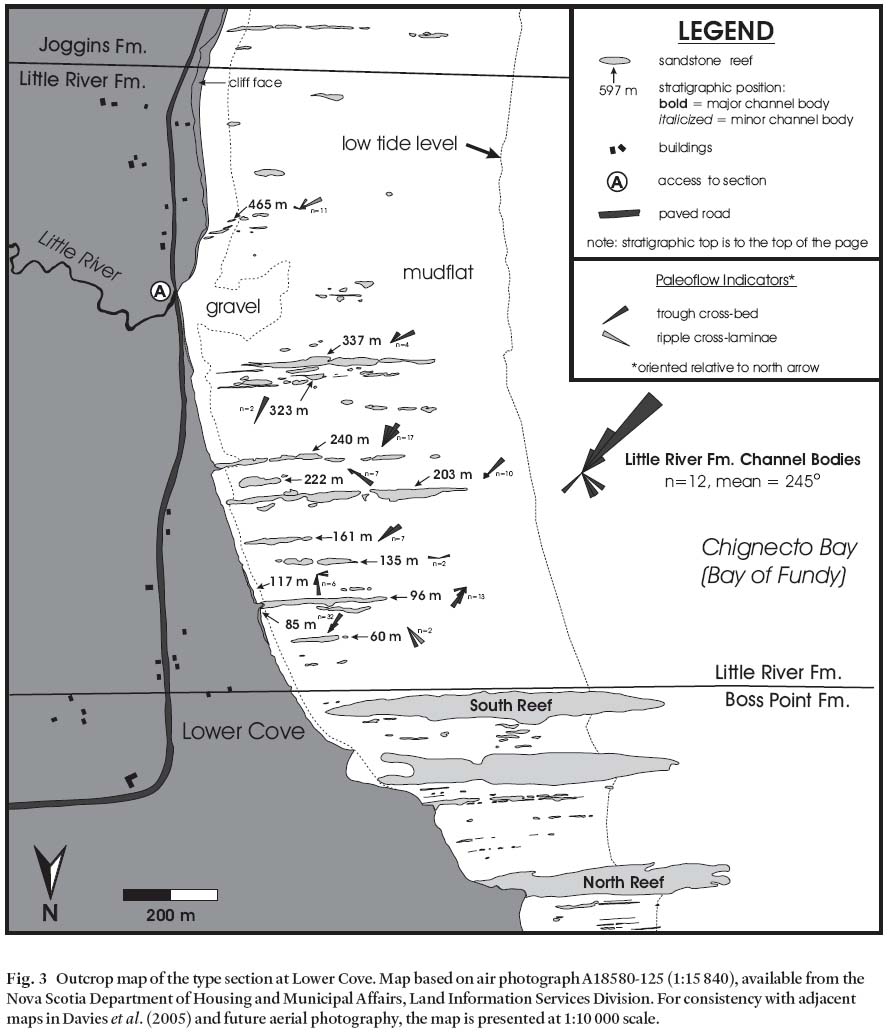
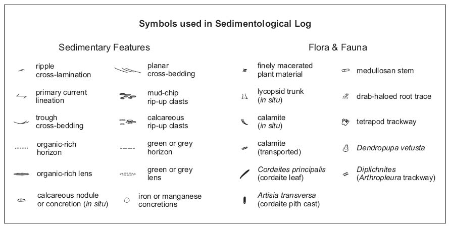
7 Logan subdivided his section into eight lithologically distinct divisions, numbered from youngest (1) to oldest (8). The red beds of Lower Cove were assigned to Division 5, and the overlying coal measures of the Joggins and Springhill Mines formations to Divisions 4 and 3 respectively. The sandstone-dominated strata of the underlying Boss Point Formation were assigned to Division 6. Logan placed the lower contact of Division 5 at the top of "South Reef" (Fig. 3), which we consider to represent the uppermost sandstone body of the Boss Point Formation. He placed the upper contact 5 ft, 6 in (1.65 m) below the stratigraphically lowest coal (no. 45) of Division 4, a bed that we propose herein as the basal datum of the revised Joggins Formation (see below).
8 Logan's "Recapitulation" of Division 5 reads as follows: "dominated by red shale, reddish grey sandstone with occasional "drift plants" and "concretionary limestone", and minor greenish grey sandstone, totally 2082 ft 0 in". The thickness of the Lower Cove red beds (634.6 m) obtained by Logan agrees remarkably closely with the thickness of 635.8 m measured in this study (a mere 1.26 m difference). Despite minor modifications and combinations over the years, Logan's (1845) measurements and subdivisions form the basis for all later stratigraphic studies of the Carboniferous basin fill of the Cumberland Basin.
Fig. 1 Location and geology of the western Cumberland Basin. Modified from Ryan et al. (1990a,b), New Brunswick Department of (2000), and St. Peter (2001).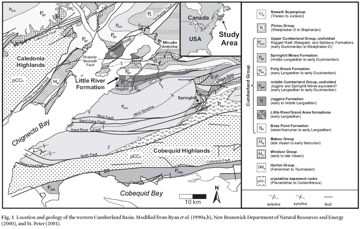
Relationship to other units within the Cumberland Basin
9 The stratigraphic relationship of the Lower Cove red beds to other units within the Basin (other than those in direct contact in the coastal exposures) has long been enigmatic. Brown and Smith (1829) did not distinguish the Lower Cove beds from their "Millstone Grit" and overlying "Coal Measures" (Fig. 2). Dawson (1855) originally assigned Divisions 5-8 to the "Lower or Older Coal-Formation", broadly analogous to the Lower Carboniferous, but later reconsidered and correlated these strata with the "Millstone-grit Series" (Dawson 1868). Grouping of Logan's Divisions into more broadly recognized lithostratigraphic units represented an attempt to correlate these stratal packages beyond the confines of the basin, but required an understanding of local sedimentation patterns within the tectonically active Cumberland Basin.
10 During the first half of the Twentieth Century, Bell (1912, 1914,1927,1938,1944,1958) studied the paleontology and regional stratigraphy of the Carboniferous of Nova Scotia. Well aware of the lithostratigraphic complexities of the Cumberland Basin, Bell felt that the basin fill could be more naturally subdivided on the basis of unconformities as indicated by the floral and faunal record. Bell's regional stratigraphy, grounded in his steadfast belief in unconformity-bound groups, became the definitive work of the Twentieth Century, but his combined use of bio- and lithostratigraphic definitions proved impractical. Influential advocates of a purely lithostratigraphic approach to the regional stratigraphy of the Maritimes Basin have been Belt (1964,1965) and Kelley (1967), and their viewpoint was followed, at least in part, by Ryan et al. (1991).
11 In his first round of stratigraphic revisions, Bell (1912,1914, 1938) grouped Logan's Divisions 3-5 and basal Division 2 into his "Joggins Formation". His grouping of the Lower Cove red beds (Division 5) with the overlying coal-bearing strata (Division 3-4) was based, in part, on the lack of contrary (or indeed any) macrofloral evidence within the red beds. Bell (1914, 1927) correlated the contact between coal-bearing strata and conglomerate at Spicer's Cove (Fig. 1) on the south limb of the Athol Syncline (Fletcher 1908) with the contact between Divisions 5 and 6 at Lower Cove. This correlation, later shown to be incorrect by Ryan et al. (1990a, 1990b), contributed to the impracticality of mapping his Shulie and Joggins formations inland (see map notes of Bell 1938). Consequently, Bell (1938) later advocated for an undivided Cumberland Series; later still, Bell (1944,1958) defined the Cumberland Group, comprising Divisions 1-5, and the Riversdale Group, comprising Divisions 6-7
12 In the mid Twentieth Century, efforts were renewed to map the basin fill. Central to this work was the goal of establishing stratigraphic relationships between the coastal section and the economically important coal measures of Springhill. In the course of this work, Shaw (1951) recognized the red beds of Lower Cove as a lithologically distinct subunit (10a) of his "coal-bearing facies" and considered the red beds to be coeval with basin-margin conglomerates (his map unit 9, the Polly Brook Formation of later authors) near Springhill (Fig. l). Copeland (1959) concurred, but grouped the Lower Cove red beds with the basin-margin conglomerates (his "Facies A").
13 On the strength of their interpretation that the coal-bearing strata of Spicer's Cove were correlative with the Joggins coals and were underlain by conglomerates exposed at the south of Spicer's Cove, Bell, Shaw and Copeland correlated the Lower Cove red beds with basin margin conglomerates. Palynostratigraphic studies (Hacquebard and Donaldson 1964; Dolby 1991) have demonstrated, however, that the Spicer's Cove section is younger than that of Lower Cove, a conclusion supported by the macrofloral record (R.H. Wagner, personal communication, 2000). A growing body of evidence further suggested that the contact between the Lower Cove red beds and the underlying Boss Point Formation was likely conformable (Hacquebard 1972; Howie and Barss 1975).
14 Later in the century, a subsequent round of mapping and stratigraphic investigations in the Cumberland Basin was undertaken by the Nova Scotia Department of Natural Resources (Ryan et al. 1990a,b,c, 1991; Calder 1995). The lithostrati-graphic distinctiveness and regionally mappable boundaries of the Lower Cove red beds were acknowledged by Ryan etal. (1990a) on their geological map, but this unit was nonetheless included with the coal-bearing strata of Division 4 and the basal 51m of Division 3 in their revised and reinstated Joggins Formation (Ryan etal. 1991). Members were not formally defined within this 1433 m-thick unit, although the informal term "Little River Bridge member" was used by Ryan etal. (1991, their fig. 5) and Ryan and Boehner (1994, their figs. 2-13) in reference to the Lower Cove red beds.
Fig. 2 Summary of stratigraphic nomenclature employed historically in reference to the Little River and Joggins formations.Fig. 3 Outcrop map of the type section at Lower Cove. Map based on air photograph A18580-125 (1:15 840), available from the Nova Scotia Department of Housing and Municipal Affairs, Land Information Services Division. For consistency with adjacent maps in Davies et al. (2005) and future aerial photography, the map is presented at 1:10 000 scale.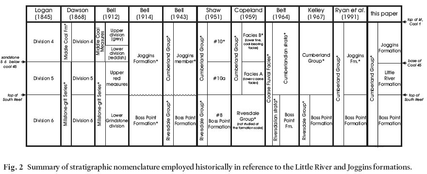
LITTLE RIVER FORMATION
Definition
15 Here we formally propose the elevation of the Lower Cove red beds to the status of formation, and coin the name Little River Formation for these beds. Our proposed unit is defined purely on the basis of lithostratigraphy, being a non-coal-bearing, red-bed succession positioned conformably above the Boss Point Formation and conformably beneath the coal-bearing strata of the Joggins Formation. The formation is named after Little River, the mouth of which crosses the type section where it enters Chignecto Bay at Lower Cove. For the sake of clarity, it is important to note that this newly proposed unit bears no relationship to the now historically obsolete "Little River Group" of southern New Brunswick (Dawson 1868, p. 506), despite these strata being approximately time-equivalent. These strata are now assigned to the Lancaster Formation of Alcock (1938), and include the classic "Fern Ledges" of Stopes (1914).
Justification
16 The Little River Formation comprises a lithologically distinctive and regionally mappable unit. It lacks both coal and bivalve-bearing limestone beds, the two defining hallmarks of the overlying Joggins Formation (Ryan et al. 1991). It is also lithologically distinct from the underlying Boss Point Formation, which is characterized by thick, multistorey, well sorted grey sandstones, features absent from the Little River Formation. Similarly, although it is considered to be, in part, coeval with the Polly Brook Formation, it is lithologically distinct from that polymictic conglomerate succession. Both the base and top of the Little River Formation are regionally important surfaces.
Type locality
17 The type section comprises outcrops in the intertidal zone and low-relief coastal bluffs on the eastern shore of Chignecto Bay, at Lower Cove, near Joggins, Cumberland County, Nova Scotia (Fig. 3). The section begins at the top (southern edge) of the South Reef of the Boss Point Formation (UTM Coordinates 5066450N, 388000E; NAD 83 datum) and extends 1500 m southward to a point 500 m south of the mouth of Little River (5063200N, 388400E). The top of the section coincides with the base of the lowest coal bed (Coal 45 of Logan 1845) of the Joggins Formation, near the start of the continuous cliff section.
Reference localities
18 Strata of the Little River Formation are known to occur inland on four stream sections east of the type section (Fig. 1; and see Ryan et al. 1990a). These include, from west to east: 1) exposures on a small tributary to the Maccan River north of the village of Maccan; 2) along Baird Brook at Chignecto; 3) near the contact with the Polly Brook Formation on Saint George's Brook east of Chignecto, which at this locality underlies the Little River Formation; and 4) on Styles Brook south of Stanley.
Boundaries
19 The basal contact of the Little River Formation is placed at the top of the highest multistorey sandstone bed of the Boss Point Formation, which at the type section is the top of the South Reef, coinciding with the base of Division 5 of Logan (1845). Inland, to the east, the base of the formation progressively onlaps against polymictic conglomerates of the Polly Brook Formation (Ryan etal. 1990a). The upper contact of the formation is placed at the base of the stratigraphically lowest coal bed, which at the type section is coal 45 of Logan (1845), 1.65m above the base of Logan's Division 4. This upper contact defines the base of the revised Joggins Formation (see Davies et al. 2005). The onset of grey mudrock and sandstone in the Joggins Formation provides a secondary criterion in mapping incompletely exposed sections. The formation has been mapped by the first author inland from the type section, its boundaries indicated on the map of Ryan etal. (1990a), where the formation, then unnamed, was designated "abundant redbeds"
Thickness and distribution
20 The type section at Lower Cove, constituting a remeasure-ment of Division 5 of Logan (1845), is 635.8 m thick. The formation can be traced 30 km to the east along the north limb of the Athol Syncline to Styles Brook (Ryan et al. 1990a), where it eventually pinches out between the underlying Polly Brook Formation and overlying Joggins and Springhill Mines formations (Fig. 1). Because of many similarities, the Lower Cove beds may be laterally equivalent to fault-bound strata exposed across Chignecto Bay to the west on Maringouin Peninsula, New Brunswick, assigned to the informal Grande Anse formation (St. Peter and Johnson 1997), as well as to undesignated strata along strike of the Grand Anse beds at Minudie Point.
Correlation
21 Inland, the Little River Formation is in part laterally time-equivalent to coal-bearing strata of the Joggins Formation and is inferred to be laterally equivalent to the Polly Brook Formation on the south limb and in the east of the Athol Syncline (Figs. 1, 4). Although it is probable that the Grande Anse formation in southeast New Brunswick may represent a fades of the Little River Formation, the correlation of the two units is problematic due to uncertainties in the stratigraphic relationship of the Grande Anse formation with adjacent geologic units. The lower contact of the Grand Anse section is in faulted contact with the Boss Point Formation at the coast, although the contact is reported to be conformable in the axis of the Hardledges Syncline south of the Shepody-Beckwith Fault (Johnson 1996). At its upper contact, the Grand Anse formation is in faulted contact with the Mississippian Windsor Group. Johnson (1996) suggested correlation of the Grande Anse with the Polly Brook Formation and lower Joggins (Little River of this paper) Formation.
Age
22 Age determination of the Little River Formation is problematic due to its sparse paleontological record and, in particular, the complete absence of key age-diagnostic marine index fossils (Calder 1998; R.H. Wagner, personal communication, 2004). Furthermore, although palynology offers an alternative means to date strata, difficulties exist in disentangling evolutionary signatures from paleoecological effects. With these uncertainties in mind, comprehensive palynostratigraphic studies of the type section place the Little River Formation within the upper Namurian (Kinderscoutian) to basal Westphalian (basal Langsettian) according to Dolby (1991,2003), or entirely within the upper Namurian (Marsdenian to Yeadonian) according to J. Utting (personal communication, 2004). Extensive revision by R.H. Wagner of the macroflora of the overlying Joggins Formation demonstrated a floral assemblage consistent with the Langsettian of Europe, and Langsettian floral elements are present along with problematic "hinterland" taxa in the underlying Boss Point Formation (Utting and Wagner 2005).
23 The miospore Cananoropolis mehtae until recently was known only from strata in the informal "Coal Mine Point member" of the Joggins Formation (Ryan et al. 1991), and was used therefore as local index taxon. Its occurrence in red beds of the Grande Anse section on Cape Maringouin, New Brunswick, was cited as evidence of a late Langsettian age for these strata (Dolby 1999). Subsequent sampling of the formation at Lower Cove, however, yielded a much earlier, albeit solitary specimen of Cananoropolis mehtae (Dolby 2003), suggesting that it may be less useful as a local index taxon than previously assumed, and therefore giving cause to reconsider the late Langsettian age for the Grande Anse formation. Its presence within the Lower Cove and Grande Anse strata further suggests that the two formations are possible correlatives.
Fig. 4 Stratigraphic units of the Joggins coastal section and their relationship to basin-fill units inland and in New Brunswick. Modified from Ryan et al. (1990a) and St. Peter (2001).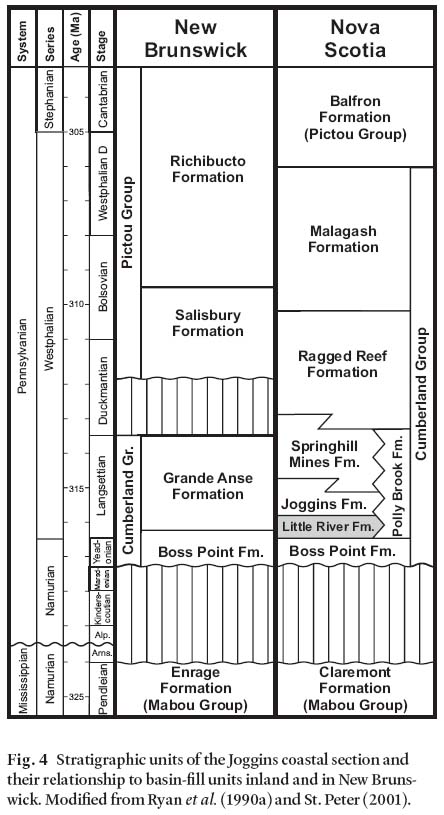
SEDIMENTOLOGY OF THE LITTLE RIVER FORMATION
Major sandstone channel bodies
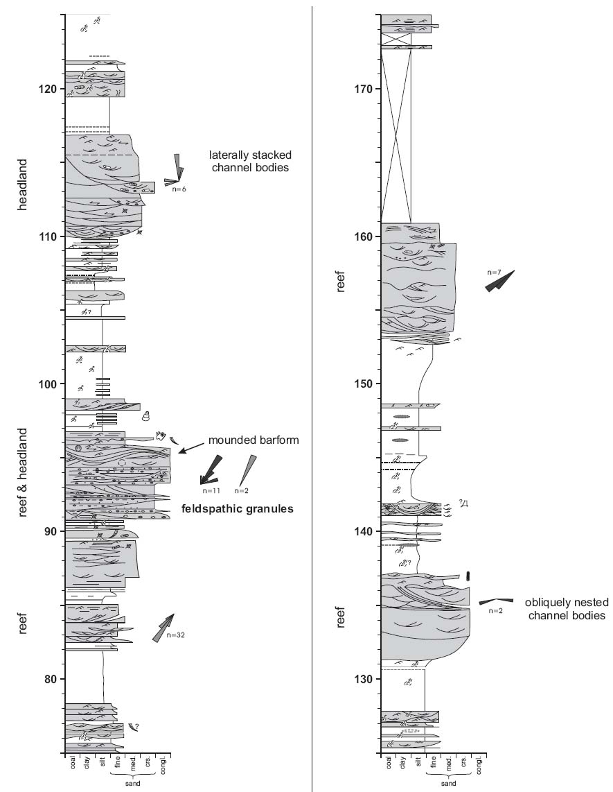
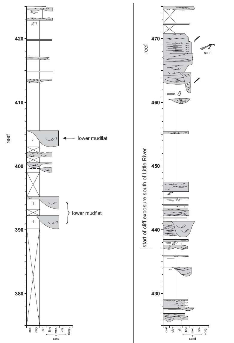
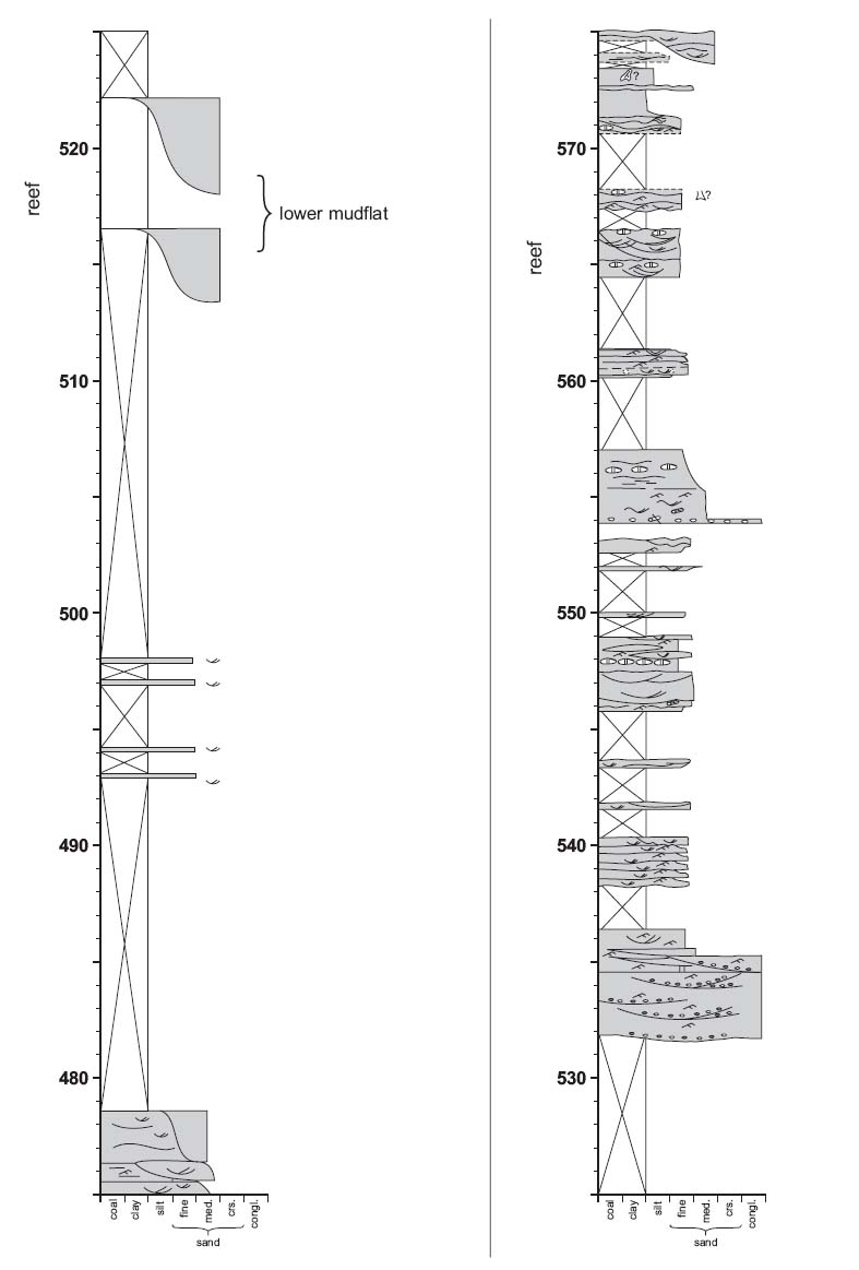
24 Twelve prominent (>2m-thick) channel bodies crop out on the wave cut platform as prominent "reefs", and vary in width from 31-534 m. Channel bodies have been assigned numerical designations (Fig. 3) that correspond to the stratigraphic position in metres of the top of their uppermost bed in the measured section. Channel bodies are described using the bounding surface and lithofacies terminology of Miall (1996). Smaller channel bodies (<2 m thick) also occur, but are dealt with separately below.
Channel body geometry
25 The lateral exposure of Little River channel bodies varies depending on their size and position on the shoreline. Five fully exposed channel bodies are 2.4 to 6 m thick and have width:thickness (W:T) ratios ranging between 6 and 43 when measured perpendicular to paleoflow. Seven incompletely exposed channel bodies are 3.1 to 10 m thick and have minimum W:T ratios of 13.6 to 147 when measured perpendicular to paleoflow.
26 The architecture of these sandstone channel bodies is defined by 5th order (channel body-) bounding surfaces, which both separate them from the underlying mudrocks and compartmentalize them into vertically stacked, or abutting, storeys. The basal storey/storeys of many channel bodies comprise(s) an obviously erosional 5th order surface, which forms one or more concave-up channel bases. These U-shaped forms are 3.1 to 7 m thick with W:T ratios between 5 and 25. Where concave-up surfaces flatten, they pass into the relatively bedding-parallel, 5th order surface that defines the base of the overlying, more tabular storey. These uppermost tabular storeys are 1 to 4 m thick with W:T ratios greater than 35. The overlying storeys are similar to the thick sandstone "wings" of Friend etal. (1979). In summary, the composite sandstone channel bodies are amalgamations of U-shaped erosional storeys and overlying, more laterally extensive storeys.
27 Internally, storeys contain numerous 3rd and 4th order bounding surfaces (macroform growth increment and mac-roform bounding, respectively) that separate the sandy fill into channel elements and sandy bedforms. Individual channel elements are generally 1.5 to 6 m thick and have a narrow, U-shape in cross-section (W:T ratio <10). Inclined stratification within sandy bedforms is variably oriented with dips ranging from perpendicular to oblique to the channel margin. Third and fourth order surfaces divide the basal part of most storeys into stacked packages of crudely stratified intraformational conglomerate (Gh) overlain by trough, planar, or low-angle cross-bedded sandstone (St, Sp and Si, respectively). The upper portions of these channel bodies, and the entirety of others (e.g. the channel body at 465 m), contain varying proportions of horizontally, low-angle, and/or ripple cross-laminated sandstone (Sh, Si, and Sr respectively). These intervals commonly contain 3rd order bounding surfaces, which are expressed as either low angle or channel-element bounding erosional surfaces.
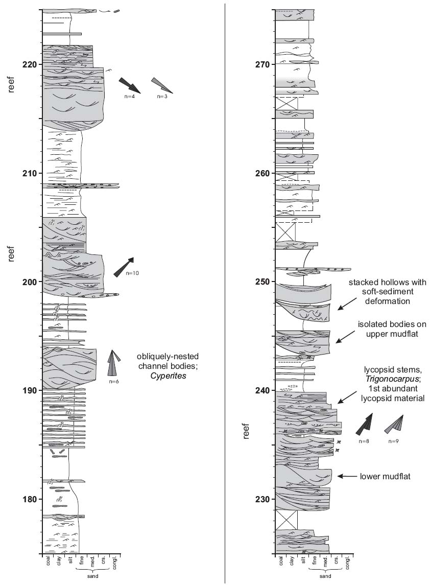
28 A shallow erosional scour atop the channel body at 96 m (see Appendix A) contains an assemblage of lithofacies unique within the Little River Formation. The 2.45 m-deep and 20 m-wide scour is incised into a 3 m-thick package of trough to low angle cross-bedded sandstone and intraformational conglomerate. The basal 0.70 m of the scour is filled with two sets of planar cross-bedded sandstone that are overlain by approximately 15 cm of horizontally laminated sandstone. A "sigmoidal" erosional surface (Fig. 5) cuts down from the channel margin, truncating these basal units. The erosion surface is draped by a form-concordant, sigmoidal blanket of ripple cross-laminated sandstone that gradually becomes flat lying and passes upward into a sheet that extends beyond the margin of the scour and caps the entire channel body.
Fig. 5 Large, sigmoidal bedform at 96 m of the measured section (Appendix A).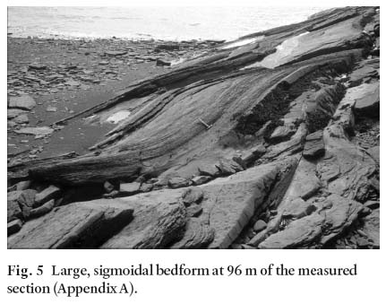
Sediment composition
29 Channel bodies generally are composed of quartz- and calcite-cemented, very fine- to medium-grained feldspathic arenites. Sandstones additionally contain abundant sand-sized clay particles with bright clay fabric, which may represent mud aggregates (Gierlowski-Kordesch and Gibling 2002; Miiller et al. 2004). Erosion surfaces are lined locally with crudely stratified intraformational conglomerate (Gh) containing medium-to coarse-grained sandstone (Ss), which is either interspersed as a matrix or co-occurs within separate lenses. Lag deposits are clast supported and contain pebble-sized rip-up clasts of red and green mudstone with rare granule-sized quartz clasts (channel body at 90 m). Locally abundant calcareous rip-up clasts are composed of concentric layers of finely crystalline calcite developed around a core of sparry calcite. Although no root tissue was observed, these clasts are otherwise identical to the calcareous rhizoconcretions described by Falcon-Lang et al. (2004) from red beds in the overlying Joggins Formation.
Paleoflow
30 The orientation of trough cross-beds and ripples in the channel bodies are plotted as rose diagrams (10° petals) on the measured section (Appendix A) and outcrop map (Fig. 3). Planar cross-beds and primary current lineations are locally abundant, but these structures are relatively unreliable indicators of paleoflow, and omitted from analysis. Measurements are grouped by structure type within individual channel bodies to allow for comparison between different scales of structures and for intrachannel variation. Because the orientation of troughs and ripples are linear features, they need not be corrected for the <25° regional dip at the Lower Cove type section (Potter and Pettijohn 1977).
31 Where ripples and trough cross-beds are measurable within the same channel body (n=3), their mean orientation varied by 1° to 19° (mean = 7.7°). Given this similarity, these structures are treated as equally reliable and used to calculate a mean paleoflow direction for each channel body (Fig. 3). The twelve Lower Cove channel bodies showed a reasonably strong southwest trend (mean = 245°, r = 0.6). Of the four bodies that deviate from this trend, three exhibit paleoflow to the northwest with the remaining one to the northeast. In comparison, trough cross-beds within Grand Anse strata at Black Point and at Grande Anse, New Brunswick, record a NNE paleoflow (Browne 1991).
Comparison with bracketing formations
32 Channel bodies of the Little River Formation are an order of magnitude smaller than those of the underlying Boss Point Formation and exhibit considerable differences in alluvial litho-facies and paleoflow direction. Browne and Plint (1994) describe the Boss Point Formation as being characterized by 20 to 90 m thick braidplain sandstone packages, which are underlain by 6th order bounding surfaces and extend several hundred metres across the intertidal zone. These bodies are composed domi-nantly of trough cross-bedded sandstone and have individual channel elements up to 35 m thick. Furthermore, the 245° (southwesterly) trend of the Little River Formation channel bodies differs from the southeasterly trend of the underlying Boss Point Formation by 70° (Browne and Plint 1994).
33 Little River Formation channel bodies also differ from those of the overlyingjoggins Formation in terms of both geometry and internal architecture. Red beds in both formations contain channel bodies between 5 and 10 m thick, but examples in the Joggins Formation contain significant amounts of interstratified mudrock, are contained within small incised valleys, and are not capped by laterally extensive storeys (Davies and Gibling 2003). Although some Joggins Formation channel bodies (e.g., Coal Mine Point) are similar in size and geometry to those in Lower Cove, these bodies are single storey and contain well developed lateral accretion surfaces (Davies and Gibling 2003). Paleoflow within the Little River and Joggins formations is variable, but large channel bodies in both tend to have a southerly or southwesterly flow orientation.
Mudrock-dominated intervals
Mudrocks
34 The Little River Formation is mudrock-rich, which contributes to its low relief in the Lower Cove type section. Mudrocks, comprising claystone to silty claystone, are predominantly red in colour. Ubiquitous drab haloed root compressions are characteristic of the formation; calcareous rhizoconcretions and amalgamated (dm-scale) carbonate nodules occur locally. Discrete, thin (cm-scale), dark grey, organic-rich mudrock intervals may occur at some horizons, and may persist laterally for tens of metres, but true coal beds are absent.
Paleosols
35 Mudrocks within the Little River Formation contain three types of paleosol, which are described here using standard terminology (Retallack 2001; Soil Survey Staff 2003). By far the most common type comprises intervals containing drab haloed root compressions, locally associated with standing vegetation. These weakly developed mineral paleosols lack horizons and represent very weakly developed entisols. Their common occurrence indicates pervasive pedogenesis throughout the accretion of the Little River Formation. Smith (1991) studied similar, but better developed paleosols in the overlyingjoggins Formation and interpreted them as paleo-alfisols formed under warm, oxidizing conditions. The absence of pedogenic carbonate in the Joggins Formation paleosols conflicts, however, with the interpretation of alfisols by DiMichele et al (in press) from Early Permian red beds of north-central Texas (see below). Other paleosols in the Little River Formation exhibit surficial horizons <10 cm thick that are composed of green or grey mudstone with variable amounts of organic material and rooting. The most organic-rich of these horizons consist of incipient histic epipedons (surface horizons) capping weakly developed entisols.
36 A distinctive aspect of the paleosols of the Little River Formation that contrasts with those of the Joggins Formation is the development of calcic (Bk) horizons. These horizons contain discontinuous carbonate-cemented nodules (<20 cm thick) that reach Machette's (1985) Stage III of carbonate accumulation. Such pedogenic carbonate development indicates xeric conditions and a semi-arid to arid climate with seasonal drying and incomplete leaching (Soil Survey Staff 2003; DiMichele et al. in press). Paleosols with vertically oriented calcareous rhizoconcretions are similar to paleosols described from the Early Permian of north-central Texas interpreted by DiMichele et al. (in press) as alfisols; more extensively cemented pedogenic carbonate was considered by these authors to be indicative of inceptisols. Clay mineralogy and petrographic studies of the Little River paleosols at Lower Cove will be required to refine these preliminary interpretations.
Small channel bodies
37 Small (<2 m thick), U-shaped (W:T <5) channel bodies occur throughout the Little River Formation, hosted within the mudrock-dominated intervals. These features have convex-down bases and flat tops; mounded tops occur locally. Channel bodies commonly occur in stacked groups where individual channel bodies are obliquely offset from one another. Small channel bodies are either isolated within mudrock or pass laterally into thin (<1 m thick) sheet sandstones. Channel fill consists of varying proportions of horizontal, low-angle, and ripple cross-laminated sandstone (Sh, Si, and Sr respectively), or more rarely may largely contain laminated, grey/green mudstone.
Sheet sandstone bodies
38 Thin (dm thick) sheet sandstones are commonly interbed-ded with red mudrocks of the Little River Formation. These beds typically extend for several tens of metres, their complete extent being unknown due to limited exposure at Lower Cove type section. Internally, sheet sandstones are often massive with localized areas of horizontal or ripple cross-laminated sandstone (Sh and Sr, respectively). The presence of drab haloed root compression and occasional calamitean plants in growth position suggests that these beds experienced some pedogenic overprinting. A few beds near the top of the section are very strongly cemented by calcite, a phenomena that may reflect pedogenic accumulation of calcite at or near the water table.
PALEONTOLOGY
39 In spite of 150 years of investigation of the rich terrestrial fossil record of thejoggins section (Falcon-Lang and Calder 2004), no floral or faunal records exist from the red beds of the Little River Formation. The first records that have emerged in the course of this study likely afford but a glimpse of the total biota of the Little River ecosystem.
Fauna
Invertebrates
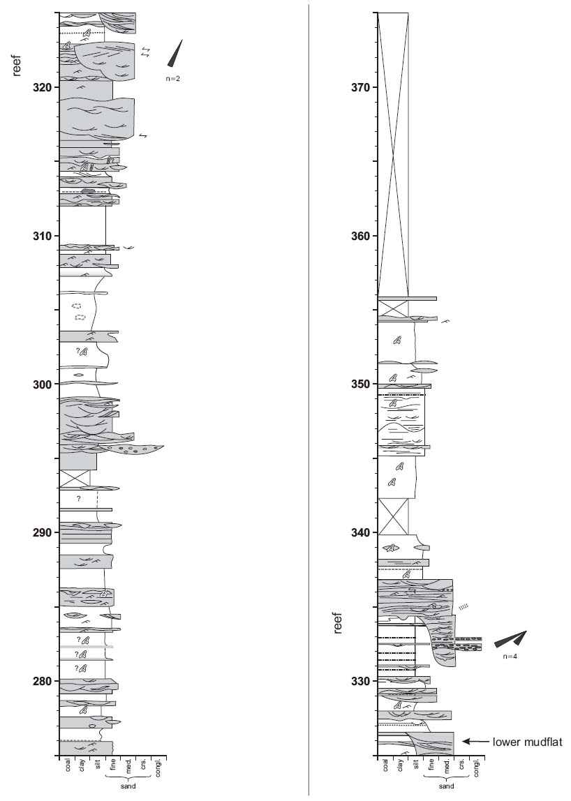
40 Aggregations of the land snail Dendropupa vetusta occur concentrated on discrete drab horizons (98 m, Appendix A). These aggregations represent surface litter accumulations (mode 2 occurrence of Hebert and Calder 2004) that are consistent with the snail's detritivorous autecology (Solem and Yochelson 1979). The Lower Cove occurrences predate those of the Joggins Formation and so push back in time the first appearance of pulmonate gastropods in the fossil record. The presence of the largest known terrestrial detritivore, the gargantuan millipede-like^rt/zrop/ewra, is recorded by a 23 cm wide Diplichnites trackway (Fig. 6; 335 m, Appendix A). The polychaete worm Spirorbis is abundant in a single, small, grey mud-filled channel at 352 m in the measured section, where the epifauna densely adheres to drifted cordaitalean trunks (see below).
Vertebrates
41 The solitary vertebrate record as yet obtained from the Little River Formation is an occurrence at one horizon of large tetra-pod footprints (96.5 m, Appendix A) provisionally assigned to the ichnogenus Pseudobradypus. The possible affinity of this ich-notaxon with the baphetid stem tetrapods and its occurrence in stratigraphic proximity to the land snail Dendropupa recall their association in the Hebert sandstone of the Joggins Formation (Hebert and Calder 2004; Falcon-Lang et al 2004).
Fig. 6 Diplichnites trail, ascribed to the huge detritivorous arthropod Arthropleura, from approx. 335 m of the measured section (Appendix A).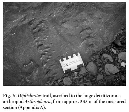
Flora
Plant compression assemblages
42 By far the most abundant macro floral impressions are sphe-nopsid stems (Catamites cistii and less commonly Calamites suckowii), which occur throughout the section as prostrate axes in channel lag deposits, and less commonly in growth position. Unfragmented Cordaites leaves, up to 22 cm in length, are common locally in red mudrock beds and channel sandstone bodies. Less commonly recorded are medullosan pteridosperm axes, rare foliage (Alethopteris sp.) and seeds (Trigonocarpus cf. parkinsonii). Lycopsid remains are very rare indeed, represented only by leaf compressions (Cyperites sp.) at 220 m in the measured section, and at 241 m, by trunk compressions (Lepidodendron sensu latu and Sigillaria cf. rugosa). Stigmarian rootstocks are completely absent. An enigmatic plant (Fig. 7) recovered from the measured section is similar to Rhacopteris busseana (R.H. Wagner, personal communication, 2004), and may represent a rarely encountered dryland or hinterland floral element.
Anatomically preserved woods
43 Multiple channel sandstone units, in particular those at 96 m and 240 m in the measured section, contain allochthonous charred blocks of wood (up to 17 mm diameter), and more rarely calcite-permineralized trunk fragments. These anatomically preserved woods are present both in channel lags and in cross-bedded intervals higher in the channel bodies. In addition, a single small mud-filled channel, hosted in a mudrock-domi-nated interval at 352 in the measured section, contains a further four calcite-permineralized trunks, 18-24 cm in diameter.
44 Scanning electron microscopy and thin section analysis shows all specimens comprise pycnoxylic coniferopsid wood of Dadoxylon-type. The best preserved examples are assigned to Dadoxylon recentium, a wood characterized by biseriate, alternate, bordered tracheid pitting (Fig. 8A), cupressoid pits per cross-field (Fig. 8B, C), and low rays (Fig. 8D). In the Joggins Formation, Dadoxylon recentium wood has been recorded in biological attachment to septate axes oiMesoxylon type (Falcon-Lang 2003), indicating that at least some of the charred wood in the Little River Formation is cordaitalean. However, some of the calcite-permineralized woods in the Little River Formation are attached to non-septate axes (up to 3-4 cm diameter, up to 45 cm long). At present it is unclear whether the absence of pith septa is a biological or taphonomic feature, but in either case, the most likely affinity of these woods is cordaitalean (Falcon-Lang 2005).
Fig. 7 Enigmatic hinterland plant similar to Rhacopteris busseana.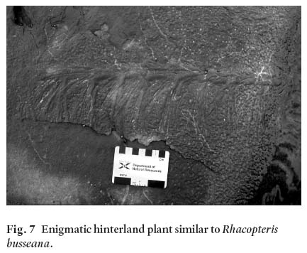
DEPOSITIONAL ENVIRONMENT OF THE LITTLE RIVER FORMATION
Facies interpretation
45 Major channel sandstone bodies of the Little River Formation represent the deposits of alluvial drainage channels. Channels are characterized by moderate incision, subsequent infilling and, where the rivers were shallow and broad, a final abandonment phase. These contrast markedly with channel deposits of similar size associated with red mudrock beds of the overlying Joggins Formation, which are incised and confined within shallow valleys (Davies and Gibling 2003). The channel forms of the Little River Formation facilitated aggradation, whereas sediment bypass and cannibalization typified the Joggins paleochannels. The flashy flow and rapid aggradation of the Little River Formation drainage channels are indicated by a sigmoidal barform preserved at 95 m (Fig. 5), which may represent a transitional antidune, and by sandy wings, which record periods of maximum discharge when flow topped levees (Friend et al. 1979). Sand-size clay grains, associated with this and other channel complexes, may represent mud aggregates or finely ground intraformational mud clasts indurated by drying and reworked from floodplain deposits.
46 The presence of petrocalcic paleosol horizons indicates pronounced rainfall seasonality and greater soil longevity than in the overlying Joggins Formation, which is characterized by weakly developed, immature paleosols (Smith 1991). Local gleyed horizons represent wetting or ponding on the floodplain, which may have been facilitated by induration of the dessicated mudrocks. Alternatively, rare Spirorbis-vich grey mudstone beds may indicate cryptic transgressive events. Although the ecological affinity of this fauna is poorly defined in the fossil record with respect to marine or freshwater environments, it is locally associated with brackish facies in the overlying Joggins Formation (Duff and Walton 1973; Skilliter 2001; Falcon-Lang 2005). Although the red beds generally reflect oxidizing, well drained conditions with sufficient sediment input to prevent extensive pedogenesis, drab haloed root compressions indicate that neither moisture deficit nor disturbance prevented plant life.
Fig. 8 Scanning electron micrographs ofDadoxylon recentium wood charcoal from 240 m (A-C) and 352 m (D) of the measured section. A: alternate, biseriate tracheid pitting; radial view, scale represents 10 pm. B: Cupressoid cross-field pits: radial view, scale represents 10 pm. C: l-2(-4) cupressoid cross-field pits; radial view, scale represents 40 pm. D: uniseriate rays (1-8 cells high); tangential view, scale represents 40 pm.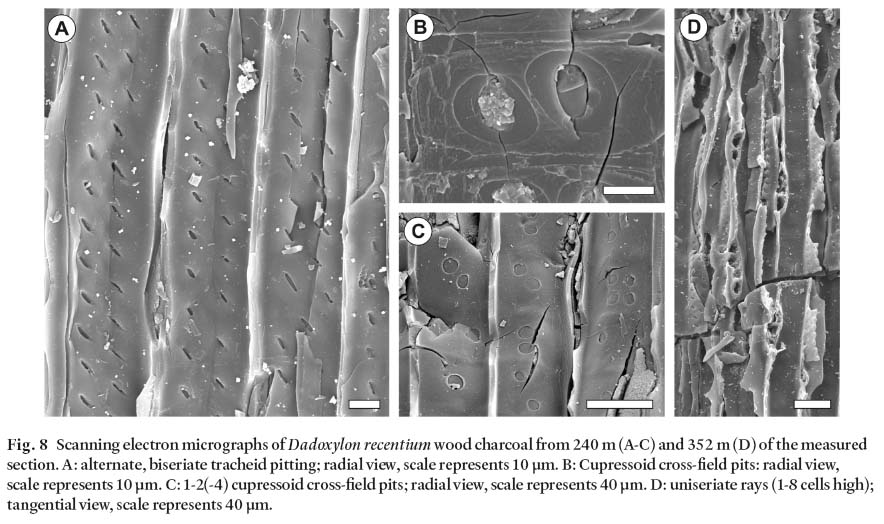
Display large image of Figure 8
47 The reproductive and growth strategies of the most common plant groups within the Little River red beds show adaptation consistent with the sedimentological record of periodic moisture deficit and aggrading sediment. The persistence of calamiteans, perhaps the most ecologically resilient of the Late Paleozoic plant groups (Calder et al. in press; DiMichele et al. in press), was aided by their prolific vegetative propagation by adventitious roots and underground rhizomes (Gastaldo 1992). Medullosan pteridosperms and cordaitaleans were assisted through dry periods by a substantial root system, which allowed them to tap deep groundwater sources (Falcon-Lang and Bashforth 2004). Although sparse, the presence of lycopsid foliage and aerial stems in the upper two-thirds of the section indicates that standing water was available for their reproduction (Phillips and DiMichele 1992), at least temporarily or in restricted areas of the landscape.
48 Stratigraphic relationships indicate that the red beds of the Little River Formation were largely coeval with the conglomerates of the Polly Brook Formation at the southern basin margin, which represent extensive alluvial fan deposits derived from the Cobequid Highlands massif to the south (Calder 1991,1994). Paleoflow indicators within the Little River Formation at Lower Cove, however, indicate a dominant source to the northeast of the type section (potentially the Caledonia Highlands), which argues against the Little River Formation as distal deposits of the Polly Brook Formation alluvial fans. The immature, feldspathic composition of certain horizons within the channel sandstone bodies at 90 and 160 m suggests, however, that the Little River Formation may include distal deposits derived from fans along the Caledonia Highlands of southern New Brunswick. Equivocal support for this hypothesis comes from the Grand Anse strata to the north and east of the type section, which exhibit a coarser, more feldspathic composition than at Lower Cove. As discussed earlier, however, the age and fault boundaries of the Grande Anse cast uncertainty on correlation of the two units.
Little Rive drylands as climate or topographic indicators
49 The clear evidence of prevailing dry conditions during deposition of the Little River Formation speaks convincingly of climate as an underlying control. However, the stratigraphic relationships within such an active basinal setting also require consideration of topographic factors that may have come into play in imparting the well-drained character of these red beds. Evidence supporting a dry or dry seasonal climate includes in situ pedogenic carbonate development, absence of coal beds, flashy paleoflow recorded within channel bodies, and the pervasive reddening of mudrocks and some sandstone bodies. The possibility of topographically related drainage effects comes indirectly from possible relationships with basin margin alluvial fan systems. Although calcareous rhizoliths are present in the Joggins Formation (Davies and Gibling 2003; Falcon-Lang et al. 2004), no in situ source beds are present in that interval, nor within the Joggins Formation. This raises the possibility of reworking from an upstream source, namely the Little River Formation red beds. The absence of bivalve-bearing beds, which record flooding events (Davies and Gibling 2003), suggests that base level was not felt within the Little River environment, with the possible exception of a single Spirorbis-rich interval. This further suggests that gradient may have enhanced drainage and so have been a factor in the development of the red beds. However, the general lack of evidence of incision by channel bodies within the Little River Formation, which would be expected if base level was lowered, does not support the enhancement of drainage by topographic relief.
50 In summary, while there is cause for considering topographic factors in draining the Little River drylands, the development of calcareous soils, complete absence of coal beds and supporting sedimentological evidence clearly required a climate regime with pronounced dry intervals. Topographically enhanced drainage may have played a contributing role.
CONCLUSIONS
51 The 635.8 m section of red beds at Lower Cove is sedimen-tologically and stratigraphically distinct from adjacent units within the Cumberland Basin, and so warrants designation as a separate formation, as first recognized by Sir William Logan. Additionally, recognition of the Little River Formation better circumscribes the definition of the overlyingjoggins Formation as coal-bearing and enhances its utility as a regionally recognizable stratigraphic unit. These revisions (summarized in Appendices B and C) confirm the pioneering work of Logan, and formally elevate his Divisions 3 and 4 to formation status. The fluvial style recorded in the Little River Formation records a dramatic change from that of the underlying Boss Point Formation, although the onset of reddening is presaged in the upper mudrocks of the Boss Point. This dramatic cessation of the Boss Point fluvial systems and their replacement by mud-rich systems is also found in other depocentres of the Maritimes Basin (Rehill et al. 1995). The landscape during deposition of the Little River Formation was substantially better drained than that of the succeeding Joggins Formation, including the seasonal dryland environments (Falcon-Lang et al. 2004; Hebert and Calder 2004). The absence of coal beds, pervasive reddening of mudrocks and sandstones and development of pedogenic carbonate within the Little River Formation are all consistent with xeric conditions and a pronounced dry season, although topographic effects may have enhanced drainage. The Little River red beds provide limiting constraints on the interpretations of seasonal drylands in the succeedingjoggins Formation, which in contrast records a gradual shift to wetter conditions with peat formation and flooding events near base level.
ACKNOWLEDGEMENTS
52 The authors acknowledge the generous input received in the field from their colleagues, in particular Susan Johnson of the New Brunswick Department of Natural Resources. The financial support of the Cumberland Regional Development Agency (CREDA) through its World Heritage initiative made possible the digital transcription of the stratigraphic logs (Appendix A), skillfully rendered by Andrew Henry. Howard Falcon-Lang acknowledges receipt of a Killam Fellowship held at Dalhousie University, and a NERC Fellowship (NER/I/S/2001/00738) at the University of Bristol. Doug MacDonald and Robert Naylor provided helpful editorial and scientific comments on the initial draft of the manuscript. The manuscript benefited greatly from the insightful reviews and stratigraphic knowledge of Peter Giles and Susan Johnson, and careful editing of Rob Fensome.
APPENDIX A
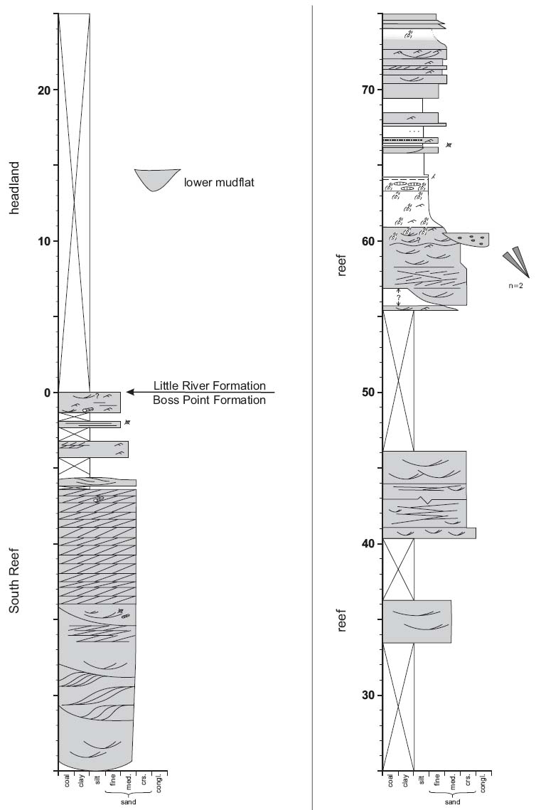
Display large image of Figure 9
Display large image of Figure 10
Display large image of Figure 11
Display large image of Figure 12
Display large image of Figure 13
Display large image of Figure 14
APPENDIX B
Standard lexicon entry for the Little River Formation.
Author: Calder, Rygel, Ryan, Falcon-Lang and Hebert 2005
Type locality: Outcrop in the intertidal zone and low-relief coastal bluffs on the eastern shore of Chignecto Bay, at Lower Cove, near Joggins, Cumberland County, Nova Scotia. The type section begins at the top (southern edge) of the South Reef of the Boss Point Formation (UTM Coordinates 5066450N, 388000E; NAD 83 datum) and extends 1500 m southwards to apoint 500 m south of the mouth of Little River (5063200N, 388400E). The top of the section coincides with the base of the lowest coal bed (Coal 45 of Logan 1845) of the Joggins Formation, near the start of the continuous cliff-section.
Lithology: A red bed succession dominated by mudrocks, which exhibit pervasive mottling from root traces and local pedogenic carbonate, with sandstone bodies typically 3-6 m thick. Coal beds and bivalve-bearing limestones are absent.
Thickness and distribution: The type section at Lower Cove is 635.8 m in thickness. The formation can be traced 30 km to the east along the north limb of the Athol Syncline to Styles Brook ("abundant red beds" of Ryan et al. 1990a), where it eventually pinches out between the underlying Polly Brook Formation and overlyingjoggins and Springhill Mines formations (Fig. 3). The Lower Cove beds exhibit many similarities with fault-bound strata exposed to the west across Chignecto Bay on Maringouin Peninsula, New Brunswick, assigned to the informal Grande Anse formation (St. Peter and Johnson 1997) and strata along strike at Minudie Point, Nova Scotia.
Relations to other units: The basal contact of the Little River Formation is placed at the top of the highest multistorey sandstone bed of the Boss Point Formation, which at the type section is the top of the South Reef, coinciding with the base of Division 5 of Logan (1845). Inland, to the east, the base of the formation progressively onlaps against polymictic conglomerates of the Polly Brook Formation (Ryan etal. 1990a). The upper contact of the formation is placed at the base of the stratigraphically lowest coal bed, which at the type section is coal 45 of Logan (1845), 1.65m above the base of Logan Divison 4. This upper contact defines the base of the revised Joggins Formation (Calder et al. this paper; Davies et al. 2005). Although it is probable that the Grande Anse formation in southeast New Brunswick may represent a facies of the Little River Formation, the correlation of the two units is problematic due to uncertainties in the stratigraphic relationship of the Grande Anse formation with adjacent geologic units: the base of the Grand Anse section is in faulted contact with the Boss Point Formation at the coast, although the contact is reported to be conformable in the axis of the Hardledges Syncline south of the Shepody-Beckwith Fault (Johnson 1996); the top of the Grand Anse section is in faulted contact with the Mississippian Windsor Group. Johnson (1996) suggested correlation of the Grande Anse with the Polly Brook Formation and lower Joggins (Little River) Formation.
Age justification: Age determination of the Little River Formation is problematic, due to its sparse paleontological record, and in particular, the absence of key age-diagnostic marine index fossils (Calder 1998). Palynostratigraphic studies of the type section place the Little River Formation within the upper Namurian (Kinderscoutian) to basal Westphalian (basal Langsettian) (Dolby 1991,2003; Utting and Wagner 2005).
History: First mapped by Logan (1845), the Little River Formation coincides almost precisely with his Division 5. Dawson (1855) originally included these strata in his "Lower or Older Coal Formation", but later (Dawson 1868) referred them to his "Millstone-grit Series". Bell (1912,1914) included the Lower Cove red beds in his Joggins Formation, but later abandoned the term (Bell 1938,1944). Ryan etal. (1991) reconstituted the Joggins Formation to be inclusive of the Lower Cove red beds but Ryan et al. (1990a) mapped their boundary with the Joggins Formation inland.
References: Bell 1912,1914,1938,1944; Calder et al. this paper; Davies et al. 2005; Dawson 1855,1868; Dolby 1991,2003; Johnson 1996; Logan 1845; Ryan etal. 1990a; Ryan et al. 1991, Utting and Wagner 2005.
APPENDIX C
Standard lexicon entry for the Joggins Formation.
Author: Calder, Rygel, Ryan, Falcon-Lang and Hebert 2005; Davies, Gibling, Rygel and Calder 2005.
Type locality: Outcrop in the coastal cliffs and wave-cut platform on the eastern shore of Chignecto Bay, near the village of Joggins, Cumberland County, Nova Scotia. The base of the type section coincides with the base of the lowest coal bed (Coal 45 of Logan 1845) near the start of the continuous cliff-section south of Little River (UTM Coordinates 5063200N, 388400E, NAD 83 datum) and extends 2800m southwards to a point south of Bell Brook and north of Dennis Point (5060700N, 386950E) that coincides with the top of the uppermost limestone unit.
Lithology: A coal-bearing succession comprising grey, siderite-bearing and reddish mudrocks, grey sandstones ranging from 3-30 m thick (Rygel 2005), bituminous coal beds typically less than one metre in thickness and associated black bivalve-bearing limestones and shales; all occurring in cycles from 16-212 m thick (Davies and Gibling 2003).
Thickness and distribution: The type section at Joggins is 915.5 m thick (Davies et al. 2005). Within the Cumberland Basin, the formation can be traced inland continuously for 40 km to the east along the north limb of the Athol Syncline, where it thins dramatically (Copeland 1959; Waldron and Rygel 2005). The formation persists as far south as Springhill, where it pinches out against, and apparently onlaps, the Polly Brook Formation (Ryan etal. 1990a; Calder 1991,1994). To the east, in the Wallace Syncline, it has been mapped through drilling in the Roslin area (Calder and Naylor 1985; Ryan et al. 1990c). The Joggins Formation is lithologically similar to the bivalve-bearing coal measures assigned to the Port Hood Formation of western Cape Breton Island, and bears lithologic similarities to the Parrsboro Formation in the Minas Basin south of the Cobequid Highlands, although bivalve-bearing shale sequences there attain greater thickness.
Relations to other units: The basal contact of the Joggins Formation is placed at the base of the lowermost coal bed, which at the type coastal section is coal 45 of Logan (1845). This contact is shared conformably with the older Little River Formation, a lithologically distinct non-coal-bearing, red bed unit (Calder et al. this paper). The formation thins to the east and south, where it overlaps the Little River red beds and progressively onlaps coarse basin margin conglomerates of the Polly Brook Formation (Ryan et al. 1991). The upper contact of the formation is given as the top of the uppermost limestone (Davies et al. 2005), which at the type section occurs in coal group 1 of Logan (1845). The upper boundary is conformable with the basal boundary of the Springhill Mines Formation which also is coal-bearing but devoid of continuous fossilifer-ous limestone beds.
Age justification: The age of the Joggins Formation has long been held to be early Westphalian, although precise correlation with European stages has been hindered by lack of open marine index fossils. Bell (1944) gave the age range as late Westphalian A-early B on the basis of macroflora but favoured an early Westphalian B (Duckmantian) assignment, later supported by Hacquebard and Donaldson (1964). Extensive palynostratigraphic analysis of the Joggins and inland sections by Dolby (1991) led him to revise the age downward to Westphalian A (Langsettian). Subsequent palynostratigraphic and macrofloral analysis have recognized Namurian elements within the paleo-botanical record but place the Joggins Formation most parsimoniously within the basal Westphalian (early Langsettian). (Calder et al, in press; Utting and Wagner 2005)
History: First mapped by Logan (1845), the Joggins Formation coincides almost precisely with his Division 4. Dawson (1868) originally included these strata in his "Middle Coal Formation". Bell (1912,1914) introduced the name Joggins Formation but later abandoned the term (Bell 1938,1944) due to difficulties in mapping the unit inland, a problem that arose in part due to inclusion of the Lower Cove red beds of Logan's Division 5 (Little River Formation of Calder et al. this paper) and in part due to his correlation of the Joggins Formation with younger coal-bearing strata at Spicer Cove. Subsequently, Shaw (1951) referred these same strata to his informal "coal-bearing fades". Copeland (1959) designated the Joggins coal-bearing strata, exclusive of the Little River red beds, as his informal "Fades B". Ryan et al. (1991) reconstituted the Joggins Formation to be inclusive of the Little River Formation red beds, although the lithological distinctiveness of the two units was recognized as a mappable boundary by Ryan et al. (1990a). Calder et al. (this paper) formally recognized the lower 635.8m red bed succession as the Little River Formation, and re-established the Joggins Formation as a coal- and bivalve limestone-bearing unit. Davies et al. (2005) suggest that the upper boundary of the Joggins Formation be modified to coincide with the top of the uppermost limestone unit as originally proposed by Logan in his Division 4. This suggestion is formalized in the present paper.
References: Bell 1912,1914,1938,1944; Calder 1991,1994; Calder and Naylor 1985; Calder et al. this paper; Calder etal, in press; Davies and Gibling 2003; Davies et al. 2005; Dawson 1868; Dolby 1991; Hacquebard and Donaldson 1964; Logan 1845; Ryan et al. 1990a; Ryan et al. 1991, Rygel 2005; Utting and Wagner 2005; Waldron and Rygel 2005.
References
Alcock, F.J. 1938. Geology of Saint John region, New Brunswick. Geological Survey of Canada, Memoir 216,65 p.
Bell, W.A. 1912. Joggins Carboniferous section of Nova Scotia. Geological Survey of Canada, Summary Report for 1911, pp.328-333.
Bell, W.A. 1914. Joggins Carboniferous section, Nova Scotia. Geological Survey of Canada, Summary Report for 1912, pp. 360-371.
Bell, W.A. 1927. Outline of Carboniferous stratigraphy and geological history of the Maritime Provinces of Canada. Transactions of the Royal Society of Canada, Section 4, pp. 75-108.
Bell, W.A. 1938. Springhill Sheet, Cumberland and Colchester counties, Nova Scotia. Geological Survey of Canada, Map 337A.
Bell, W.A. 1944. Carboniferous rocks and fossil floras of northern Nova Scotia. Geological Survey of Canada, Memoir, 238,277 p.
Bell, W.A. 1958. Possibilities for the occurrence of petroleum reservoirs in Nova Scotia. Nova Scotia Department of Mines Report, 177 p.
Belt, E.S. 1964. Revisions of Nova Scotia middle Carboniferous units. American Journal of Science, 262, pp. 653-673.
Belt, E.S. 1965. Stratigraphy and paleogeography of Mabou Group and related middle Carboniferous facies, Nova Scotia, Canada. Geological Society of America Bulletin, 76, pp. 777-802.
Brown, R., & Smith, R. 1829. Geology and mineralogy. In An Historical and statistical account of Nova Scotia, Volume 2. Edited by l.C. Haliburton. Joseph Howe, Halifax, pp.414-453.
Browne, G.H. 1991. The sedimentology of the Boss Point Formation (Pennsylvanian), eastern New Brunswick and northern Nova Scotia. Unpublished Ph.D. thesis, University of Western Ontario, London, Ontario.
Browne, G.H., & Plint, A.G. 1994. Alternating braidplain and lacustrine deposition in a strike-slip setting: the Pennsylvanian Boss Point Formation of the Cumberland Basin, Maritime Canada. Journal of Sedimentary Research, B64, pp. 40-59.
Calder, J.H. 1991. Controls on Westphalian peat accumulation: the Springhill Coalfield, Nova Scotia. Unpublished Ph.D. thesis, Dalhousie University, Halifax, Nova Scotia, 310 p.
Calder, J.H. 1994. The impact of climate change, tectonism and basin hydrology on the formation of Carboniferous tropical intermontane mires: the Springhill Coalfield, Cumberland Basin, Nova Scotia. Palaeogeography, Palaeo-climatology, Palaeoecology, 106, pp. 323-351.
Calder, J.H. 1995. Geology map of the Springhill Coalfield, Cumberland County, Nova Scotia, Nova Scotia Department of Natural Resources, Mines and Minerals Branch, Map 95-1.
Calder, J.H. 1998. The Carboniferous evolution of Nova Scotia. In Lyell: the past is the key to the present. Edited by D.J. Blundell and A.C. Scott. Geological Society of London, Special Publication, 143, pp. 261-302.
Calder, J.H., & Naylor, R.D. 1985. Coal exploration in alluvial fan-lacustrine settings: the Salt Springs and Roslin districts of the Cumberland Basin. Mines and Minerals Branch Report of Activities 1984, Nova Scotia Department of Mines and Energy Report 85-1, pp. 5-9.
Calder, J.H., Gibling, M.R., Scott, A.C, Davies, S.J., & Hebert, B.L. in press. A fossil lycopsid forest succession in the classic Joggins section of Nova Scotia: paleoecology of a disturbance-prone Pennsylvanian wetland. In Wetlands through time. Edited by S.F. Greb and W.A. DiMichele. Geological Society of America, Special Paper 399.
Copeland, M.J. 1959. Coalfields, west half Cumberland County, Nova Scotia. Geological Survey of Canada, Memoir 298,89 p.
Davies, S.J., & Gibling, M.R. 2003. Architecture of coastal and alluvial deposits in an extensional basin: the Carboniferous Joggins Formation of eastern Canada. Sedimentology, 50, pp. 415-439.
Davies, S.J., Gibling, M.R., Rygel, M.C., & Calder, J.H. 2005. The Pennsylvanian Joggins Formation of Nova Scotia: sedimentological log and stratigraphic framework of the historic fossil cliffs. Atlantic Geology, 41, pp. 115-142.
Dawson, J.W. 1855. Acadian geology. An account of the geological structure and mineral resources of Nova Scotia, and portions of the neighboring provinces of British America. 1st edition. Oliver and Boyd, Edinburgh, 388 p.
DawsonJ.W. 1868. Acadian geology. The geological structure, organic remains, and mineral resources of Nova Scotia, New Brunswick, and Prince Edward Island. 2nd edition. Macmil-lan, London, 694 p.
DawsonJ.W. 1878. Acadian geology. The geological structure, organic remains, and mineral resources of Nova Scotia, New Brunswick, and Prince Edward Island. 3rd edition. Macmil-lan, London, 825 p.
DiMichele, W.A., Tabor, N.J., Chaney, D.S., & Nelson, W.J. in press. From wetlands to wet spots: the fate and ecological significance of Carboniferous elements in early Permian coastal plain floras of north-central Texas. In Wetlands through time. Edited by S.J. Greb and W.A. DiMichele. Geological Society of America, Special Paper 399.
Dolby, G. 1991. The palynology of the western Cumberland Basin, Nova Scotia. Nova Scotia Department of Mines and Energy Open File Report 91-006,39 p.
Dolby, G. 1999. Palynological analysis of the Grande Anse Formation, New Brunswick. Report 99.16 to the New Brunswick Department of Natural Resources, November, 1999. (Unpublished report)
Dolby, G. 2003. Palynological analysis often outcrop and core-hole samples from Nova Scotia. Nova Scotia Department of Natural Resources Open File Report ME 2003-005,7 p.
Duff, P.M.D., & Walton, E.K. 1973. Carboniferous sediments at Joggins, Nova Scotia. Septieme Congres International de Stratigraphie et de Geologie du Carbonifere, Krefeld, Compte Rendu, 2, pp. 365-379.
Falcon-Lang, H.J. 2003. Anatomically-preserved cordaitalean trees from Lower Pennsylvanian (Langsettian) dryland alluvial-plain deposits at Joggins, Nova Scotia. Atlantic Geology, 39, pp. 259-265.
Falcon-Lang, H.J. 2005. Small cordaitalean trees in a marine-influenced coastal habitat in the Pennsylvanian Joggins Formation, Nova Scotia, Canada. Journal of the Geological Society, London, 162, pp. 485-500.
Falcon-Lang, H.J.,&Bashforth, A.R. 2004. Pennsylvanian uplands were forested by giant cordaitalean trees. Geology, 32, pp. 417-420.
Falcon-Lang, H.J., & Calder, J.H. 2004. UNESCO World Heritage and the Joggins fossil cliffs of Nova Scotia. Geology Today, 20, pp. 140-144.
Falcon-Lang, H.J., Rygel, M.C., Gibling, M.R., & Calder, J.H. 2004. Early Pennsylvanian waterhole deposit and its fossil biota in dryland alluvial plain setting, Joggins, Nova Scotia. Journal of the Geological Society, London, 161, pp. 209-222.
Fletcher, H. 1908. Section of rocks from Shulie to Spicer Cove, Cumberland County, Nova Scotia, in descending order. Proceedings and Transactions of the Nova Scotian Institute of Science, 11, pp. 500-550.
Friend, P.F., Slater, M.J., & Williams, R.C. 1979. Vertical and lateral building of river sandstone bodies, Ebro Basin, Spain. Journal of the Geological Society of London, 136, pp. 39-46.
Gastaldo, R.A. 1992. Regenerative growth in fossil horsetails following burial by alluvium. Historical Biology, 6, pp. 203-219.
Gesner, A. 1836. Remarks on the geology and mineralogy of Nova Scotia. Gossip and Coade, Halifax, 272 p.
Gesner, A. 1843. A geological map of Nova Scotia, with an accompanying memoir. Quarterly Journal of the Geological Society of London, 4, pp. 186-190.
Gibling, M.R. 1987. A classic Carboniferous section; Joggins, Nova Scotia. In Geological Society of America Centennial Field Guide, Northeast Section. Edited by D.C. Roy. pp. 409-414.
Gierlowski-Kordesch, E.H., & Gibling, M.R. 2002. Pedoge-nic mud aggregates in rift sedimentation. In Sedimentation in continental rifts. Edited by G.M. Ashley and R. Renaut. Society for Sedimentary Geology, Special Publication, 73, pp.195-206.
Hacquebard, P.A. 1972. The Carboniferous of eastern Canada. In Compte Rendu, 7th International Congress on Carboniferous Stratigraphy and Geology, Krefeld, Germany, 7, pp. 69-90.
Hacquebard, P.A., & Donaldson, J.R. 1964. Stratigraphy and palynology of the Upper Carboniferous coal measures in the Cumberland Basin of Nova Scotia, Canada In Compte Rendu, 5th International Congress on Carboniferous Stratigraphy and Geology, Paris, 3, pp. 1157-1169.
Hebert, B.L., & Calder, J.H. 2004. On the discovery of a unique terrestrial faunal assemblage in the classic Pennsylvanian section at Joggins, Nova Scotia. Canadian Journal of Earth Sciences, 41, pp. 247-254.
Howie, R.D., & Barss, M.S. 1975. Upper Paleozoic rocks of the Atlantic provinces, Gulf of St. Lawrence, and adjacent continental shelf. In Offshore geology of eastern Canada. Edited by B.R. Pelletier, W.J.M. Van der Linden and J.A. Wade. Geological Survey of Canada, Paper 74-30, 2, pp. 35-50.
Johnson, S.C. 1996. Lithostratigraphic revision of Westphalian strata of the Salisbury Formation and the implications for a group boundary in southeastern New Brunswick. In Current research 1995, Edited by B.M.W. Carroll, New Brunswick Department of Natural Resources and Energy, Minerals and Energy Division, Mineral Resource Report 96-1, pp. 45-60.
Kelley, D.G. 1967. Some aspects of Carboniferous stratigraphy and depositional history in the Atlantic Provinces. In Collected papers on geology of the Atlantic region: Hugh Lilly memorial volume. Edited by E.R.W. Neale and H. Williams. Geological Association of Canada, Special Paper, 4, pp. 213-228.
Logan, W.E. 1845. A section of the Nova Scotia coal measures as developed at Joggins on the Bay of Fundy, in descending order, from the neighbourhood of the west Ragged Reef to Minudie, reduced vertical thickness. In Appendix W: Geological Survey. Journals of the Legislative Assembly of the Province of Canada, 1844-5,4, pp. 28-45.
Lyell, C. 1843. On the coal-formation of Nova Scotia, and on the age and relative position of the gypsum and accompanying marine limestones. Quarterly Journal of the Geological Society of London, 4, pp. 184-186.
Lyell, C. 1871. The student's elements of geology. Harper, NewYork,640p.
Machette, M.N. 1985. Calcic soils of the southwestern United States. In Soils and Quaternary geology of the southwestern United States. Edited by D.L. Weide. Geological Society of America, Special Paper, 203, pp. 1-21.
Miall, A.D. 1996. The geology of fluvial deposits. Springer-Verlag, New York, 582 p.
Muller,R.,Nystuen,J.P.,& Wright, V.P. 2004. Pedogenic mud aggregates and paleosol development in ancient dryland river systems: criteria for interpreting alluvial mudrock origin and floodplain dynamics. Journal of Sedimentary Research, 74, pp. 537-551.
New Brunswick Department of Natural Resources and Energy, 2000. Bedrock geology of New Brunswick. New Brunswick Department of Natural Resources and Energy, Minerals and Energy Division, Map NR-1, scale 1:500 000.
Phillips, T.L., & DiMichele, W.A. 1992. Comparative ecology and life-history biology of arborescent lycopsids in v Late Carboniferous swamps of Euramerica. Annals of the Missouri Botanical Garden, 79, pp. 560-588.
Poole, H.S. 1908. A section of Carboniferous rocks in Cumberland County, Nova Scotia: (l) detailed section of rocks from West Ragged Reef to the Joggins mines and Minudie, by Sir William E. Logan (republished); and (2) from Shulie to Spicer Cove, by Hugh Fletcher. Proceedings and Transactions of the Nova Scotian Institute of Science, 11, pp. 417-550.
Potter, P.E., & Pettijohn, F.J. 1977. Paleocurrents and basin analysis. Springer-Verlag, New York, 425 p.
Rehill, T.A., Gibling , M.R., & Williamson, M.A. 1995. Stratigraphy of the central Maritimes Basin, eastern Canada: non-marine sequence stratigraphy. Geological Survey of Canada, Current Research, 1995-E,pp. 221-231.
Retallack, G.J. 2001. Soils of the past. 2nd edition. Blackwell, Ames, Iowa, 404 p.
Ryan, R.J., & Boehner, R.C. 1994. Geology of the Cumberland Basin, Cumberland, Colchester and Pictou counties, Nova Scotia. Nova Scotia Department of Natural Resources, Memoir, 10,222 p.
Ryan, R.J., Boehner, R.C, Deal, A., & Calder, J.H. 1990a. Cumberland Basin geology map, Amherst, Springhill and Parrsboro, Cumberland County. Nova Scotia Department of Mines and Energy, Map 90-12, scale 1:50 000.
Ryan, R.J., Boehner, R.C, & Deal, A. 1990b. Cumberland Basin geology map, Apple River and Cape Chignecto, Cumberland County, Nova Scotia Department of Mines and Energy, Map 90-11, scale 1:50 000.
Ryan, R.J., Boehner, R.C, & Deal, A. 1990c. Cumberland Basin geology map, Oxford and Pugwash, Cumberland County, Nova Scotia Department of Mines and Energy, Map 90-13, scale 1:50 000.
Ryan, R.J., Boehner, R.C, & Calder, J.H. 1991. Lithostrati-graphic revisions of the upper Carboniferous to lower Permian strata in the Cumberland Basin, Nova Scotia and the regional implications for the Maritimes Basin in Atlantic Canada. Bulletin of Canadian Petroleum Geology, 39, pp. 289-314.
Rygel, M.C. 2005. Alluvial sedimentology and basin analysis of Carboniferous strata near Joggins, Nova Scotia, Atlantic Canada. Unpublished Ph.D. thesis, Dalhousie University, Halifax, Nova Scotia, 468 p.
Rygel, M.C, & Shipley, B.C. 2005. "Such a section as never was put together before": Logan, Dawson, Lyell, and mid-Nineteenth-Century measurements of the Pennsylvanian Joggins section of Nova Scotia. Atlantic Geology, 41, pp. 87-102.
Shaw, W.S. 1951. Preliminary map, Springhill, Cumberland, and Colchester counties, Nova Scotia. Geological Survey of Canada, Paper 51-11.
Skilliter, D.M. 2001. Distal marine influence in the Forty Brine section, Joggins, Nova Scotia, Canada. Unpublished Ph.D. thesis, Boston College, 96 p.
Smith, M.G. 1991. The floodplain deposits and palaeosol profiles of the Late Carboniferous Cumberland Coal Basin exposed at Joggins, Nova Scotia, Canada. Unpublished M.Sc. Thesis, University of Guelph, Guelph, Ontario, 372 p.
Soil Survey Staff. 2003. Keys to soil taxonomy. 9th edition. United States Department of Agriculture Natural Resources Conservation Service, 332 p.
Solem,A.,&Yochelson,E.L. 1979. North American Paleozoic land snails, with a summary of other Paleozoic nonmarine snails. U.S. Geological Survey Professional Paper, 1072. United States Government Printing Office, Washington, D.C
St. Peter, C. 2001, Carboniferous geological compilation map of southeastern New Brunswick comprising NTS quadrangles 21 H/10, 21 H/15, 21 H/16, 211/01, 211/02, and 11 L/04. New Brunswick Department of Natural Resources and Energy, Minerals and Energy Division, Plate 2001-5, scale 1:150 000.
St. Peter, C, & Johnson, S. 1997. Maritimes Basin Project, southeastern New Brunswick, NATMAP field tripjune 1997. Unpublished field guidebook, 53 p.
Stopes, M.C. 1914. The 'Fern Ledges' Carboniferous flora of St. John, New Brunswick. Geological Survey of Canada Memoir 41,142 p.
Utting, J., & Wagner, R.H. 2005. Megaflora of the Upper Carboniferous Cumberland Group, Joggins area, Nova Scotia and New Brunswick. Geological Association of Canada Annual Meeting, Halifax, Nova Scotia, Abstracts Volume 30, p. 197.
Waldron, J.W.F., & Rygel, M.C. 2005. Role of evaporite withdrawal in the preservation of a unique coal-bearing succession: Pennsylvanian Joggins Formation, Nova Scotia. Geology, 33, pp. 337-340.
Editorial responsibility: Robert A. Fensome