A synopsis of the geology of the Cobequid Highlands, Nova Scotia
George Pe-piperDepartment of Geology, Saint Mary's University, Halifax, N.S. B3H 3C3, Canada
David J.W. Piper
Geological Survey of Canada (Atlantic), Bedford Institute of Oceanography, P.O. Box 1006, Dartmouth, N.S. B2Y 4A2, Canada
Date received: October 3, 2002 ¶ Date accepted: February 14, 2003
ABSTRACT
The Cobequid Highlands of Nova Scotia constitute a horst, originally developed in the latest Devonian, exposing Neoproterozoic Avalon terrane rocks on the northern side of the Cobequid Fault. The Neoproterozoic rocks consist of arc volcanic and plutonic rocks and associated sedimentary rocks in two major blocks. The geology of the Jeffers block is similar to that of the Antigonish Highlands, with volcanic rocks and turbidites intruded by granodioritic and granitic plutons. The Bass River block, in the southeast, shows evidence of shear-zone emplacement of a suite of plutonic rocks ranging from gabbro to granodiorite to granite into tectonically juxtaposed ocean floor volcanic and shelf sedimentary rocks. The highlands are dominated by E—W trending faults of the Late Paleozoic Cobequid Shear Zone, which developed during oblique convergence between the Avalon and Meguma terranes, and which facilitated the emplacement of gabbro and granite plutons and their extrusive equivalents (Fountain Lake Group) in the latest Devonian — earliest Carboniferous. Lower Paleozoic sedimentary rocks, including Silurian to early Devonian shelf sandstone and siltstone, were highly dismembered by faults associated with terrane convergence. The youngest stratified rocks in the Cobequid Highlands comprise fluvial and lacustrine sedimentary rocks of the latest Devonian — Tournaisian Horton Group, which accumulated in fault-bound basins. This paper reviews the regional geology of the Cobequid Highlands and provides a comprehensive bibliography of recent work.RESUMÉ
Le massif de Cobequid en Nouvelle-Écosse constitue un horst, qui est initialement apparu à la toute fin du Dévonien et qui a mis à nu des roches du terrane néoprotérozoïque d'Avalon sur la lèvre septentrionale de la faille de Cobequid. Les roches du Néoprotérozoïque se composent de roches volcaniques et plutoniques d'arcs et de roches sédimentaires associées au sein de deux blocs d'importance. La composition géologique du bloc de Jeffers est semblable à celle du massif d'Antigonish : des roches volcaniques et de les turbidites sont pénétrées par des plutons granodioritiques et granitiques. Le bloc de Bass River, dans le sud-est, témoigne de l'intrusion d'une zone de cisaillement constituée d'un cortège de roches plutoniques variant du gabbro à la granodiorite puis au granite dans des roches sédimentaires du plateau continental et volcaniques tectoniquement juxtaposées du plancher océanique. Le massif présente une prédominance de failles orientées d'est en oust de la zone de cisaillement du Paléozoïque tardif de Cobequid, qui se sont constituées pendant la période de convergence oblique entre les terranes d'Avalon et de Meguma et qui ont facilité l'intrusion du gabbro et des plutons de granite ainsi que de leurs équivalents extrusifs (groupe Fountain Lake) à la toute fin du Dévonien et au tout début du Carbonifère. Les roches sédimentaires du Paléozoïque inférieur, y compris le siltstone et le grès continental du Silurien et du Dévonien précoce, ont été fortement démembrées par les failles associées à la convergence des terranes. Les roches stratifiées les plus récentes du massif de Cobequid comprennent des roches sédimentaires fluviales et lacustres du Dévonien le plus tardif – le groupe tournaisien de Horton – qui se sont accumulées dans des bassins délimités par des failles. Cet exposé examine la structure géologique régionale du massif de Cobequid et fournit une bibliographie détaillée des travaux récents.INTRODUCTION
Geological background
1 The Cobequid Highlands (Fig. 1) consist of Avalonian Neoproterozoic rocks, Silurian to Lower Devonian sedimentary rocks, and widespread latest Devonian to early Carboniferous plu-tons and their volcanic equivalents. The Cobequid Highlands lie north of the Cobequid - Chedabucto fault zone, the term applied to a series of faults, with a wide range of ages, which mark the upper crustal expression of the crustal scale Minas Geofracture (Keppie 1982) between the Avalon and Meguma terranes. Late Paleozoic strike-slip motion on this system within and adjacent to the Cobequid Highlands formed the Cobequid Shear Zone. The Cobequid Fault (Fig. 2), which marks the southern margin of the Cobequid Highlands horst, is part of the Cobequid Shear Zone that was reactivated as a basin-margin fault in the Triassic (Withjack et al. 1995). Within the highlands, the Rockland Brook Fault separates two contrasting blocks of Neoproterozoic rocks, the Bass River block to the south and the Jeffers block to the north (Fig. 3) and appears to continue westward in the Kirkhill Fault. The northern margin of the Cobequid Highlands is largely fault-bound, with the Spicers Cove Fault in the west and a series of unnamed faults in the east (Durling 1996), with minor overstep of upper Carboniferous rocks of the Cumberland Basin (Fig. 2). A series of faults striking E—W has been mapped between the Rockland Brook Fault and the northern margin of the Cobequid Highlands, resulting in outcrop belts trending E—W of Neoproterozoic, Silurian, and Devonian—Carboniferous rocks.
Fig. 1 Maps showing the regional setting of the Cobequid Highlands. Avalonian terranes or blocks: Caledonia = Caledonia terrane; Cobequids = Cobequid Highlands (Jeffers and Bass River blocks); Ant. = Antigonish Highlands (including Georgeville block); Mira = Mira terrane.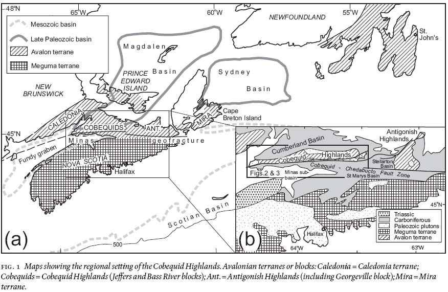
Display large image of Figure 1
2 The Late Neoproterozoic rocks of the Cobequid Highlands, particularly those of the Jeffers block, show similarities to rocks of comparable age in the Antigonish Highlands (Murphy et al. 1992), as do the Silurian sedimentary rocks. These two highland areas are separated by Carboniferous rocks of the Stellarton Basin (Fig. 1b). Much of the Cobequid Highlands is underlain by latest Devonian — earliest Carboniferous granite and gabbro plutons and their extrusive equivalents, the Fountain Lake Group. Terrestrial fluvial and lacustrine sediments accumulated in small basins of mid Devonian to early Carboniferous age.
3 The Cobequid Highlands are geologically important for several reasons. The Neoproterozoic units include a wide range of plutonic and volcanic rocks, the tectonic setting of which can be well defined. These Neoproterozoic rocks form a geographic link between that part of the Avalon terrane outcropping in southern New Brunswick and the Avalonian rocks of the Antigonish Highlands and southern Cape Breton Island (Fig. 1a). The Cobequid Highlands include the only thick early Carboniferous basalt succession in Atlantic Canada, overlying several kilometres of latest Devonian rhyolite. The abundance of granitic and gabbroic plutons of similar age points to a major role for the Cobequid Shear Zone in controlling the locus of igneous activity.
Methods and data
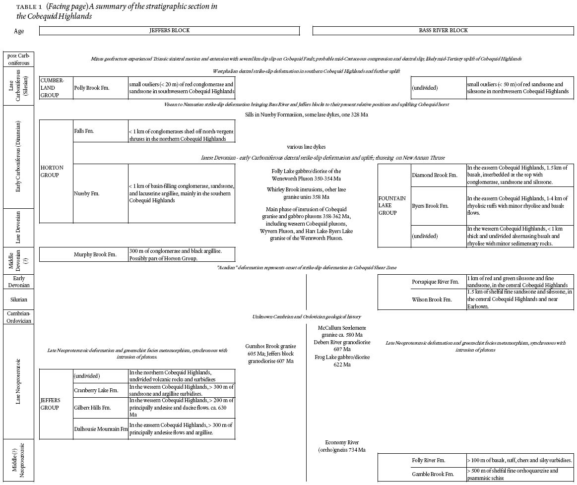
4 This short synopsis of the geology of the Cobequid Highlands is based in part on new 1:50 000 mapping of the area from Cape Chignecto in the west to Mount Thom in the east. The geology of this area is summarized in Figure 2, showing Upper Paleozoic rocks and Figure 3, showing Neoproterozoic and Lower Paleozoic rocks. We also briefly synthesize key information previously published in a dispersed manner over the past twenty years. The stratigraphic section in the Cobequid Highlands is summarized in Table 1.
5 The series of maps published by Donohoe and Wallace (1982) and their supporting text (Donohoe and Wallace 1980, 1985) formed the initial basis for our program of more detailed geological investigations and mapping. We have in general followed their stratigraphic nomenclature. Donohoe and Wallace (1985) provided a synthesis and bibliography of earlier work, including Geological Survey of Canada work in the late 1960's by Kelley (1966) and Eisbacher (1967, 1969, 1970). The field notes and plotting sheets of Donohoe and Wallace are available through the N.S. Dept. of Natural Resources. Information on mineral localities was presented by Donohoe (1982) and by Ervine (1994). Murphy et al. (2001) provided an account of mapping in the eastern Cobequid Highlands during the late 1980's.
6 Information on all 15 000 outcrops that we have examined is available as a Fieldlog database either from the Geological Survey of Canada (Atlantic) or the Nova Scotia Department of Natural Resources; a preliminary version was released by Lynch et al. (1998). Detailed geochemical and petrological data have been released as a series of Geological Survey of Canada Open Files (Pe-Piper and Turner 1988a; Pe-Piper et al. 1994; Pe-Piper 1996; Pe-Piper and Piper 1998a; Pe-Piper 1998, 2001; Pe-Piper et al. 2002; Pe-Piper and Dessureau 2002). Detailed studies of selected areas are reported in fourteen B.Sc. honours theses (Blank 1985; Bond 1999; Boner 1985; Clerk 1987; Dessureau 1998; Doucette 1996; Goulden 1998; Hilton 1998; Hubley 1987; MacDonald 1984; Nearing 1992; Pass 1993; Selway 1991; Zeeman 1992).
Fig. 2 Summary geological map of the Cobequid Highlands showing Upper Paleozoic rocks and major late Paleozoic — Mesozoic faults. DBFm = Diamond Brook Formation; BBFm = Byers Brook Formation (cf. Table 1); LF = Londonderry Fault; MF = Millsville Fault. Dashed line shows margin of Wentworth Pluton.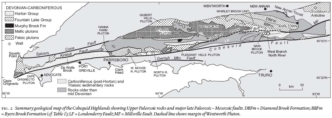
Display large image of Figure 2

Display large image of Figure 3
Table 1 (Facing page) A summary of the stratigraphic section in the Cobequid Highlands
PRECAMBRIAN ROCKS
Introduction
7 The Precambrian rocks of the Cobequid Highlands occur in two distinct blocks with quite different geology, the Bass River and Jeffers blocks, separated by the Rockland Brook Fault (Fig. 3). (Note that mappable units listed in Table 1 and shown on our 1:50 000 maps to be released by the Nova Scotia Department of Natural Resources are given in italics where first introduced.) The Bass River and Jeffers blocks consist principally of Late Neoproterozoic rocks. Not included in either block is the Economy River Gneiss, a granodioritic orthogneiss that has yielded a U-Pb zircon age of 734 Ma (Doig et al. 1993) and is geochemically distinct from other Neoproterozoic granodiorite units. The previously reported "West Moose River anorthosite" (Pe-Piper and Dessureau 2002) consists of rocks trucked from western Newfoundland and dumped in an abandoned gravel pit.
The Bass River block
8 The Bass River block (Nance and Murphy 1990) consists of a series of fault slices of Neoproterozoic shelf siliciclastic sedimentary rocks (Gamble Brook Formation), tectonically juxtaposed with ocean-floor basalt and a thin cover of pelagic sedimentary rocks and fine-grained turbidites (Folly River Formation: Pe-Piper and Murphy 1989), and intruded by a series of plutonic rocks (Table 1, Fig.3). The Gamble Brook Formation contains detrital zircon grains as young as 1183 Ma (Keppie et al. 1998), thus placing a maximum age on the formation. Individual plutons are difficult to define because of the tectonic dismemberment of the Bass River block, but three principal plutonic rock types are distinguished: the Frog Lake gabbro/diorite unit, the Debert River granodiorite unit and the McCallum Settlement granite unit (Pe-Piper et al. 1996a). The first two units occur principally as sheets tens to hundreds of metres thick within the Gamble Brook Formation, with structures indicating emplacement during shearing (Pe-Piper et al. 1996). Geochronology by 40Ar/39Ar on hornblende (Keppie et al.1990) and U-Pb on zircon (Doig et al. 1991) showed that the Frog Lake gabbro/diorite is about 622 Ma and the Debert River granodiorite 609 — 605 Ma. Poor quality U-Pb and Rb-Sr ages of ca. 575 Ma (Doig et al. 1991) have been obtained from the McCallum Settlement granite unit, which cuts the Debert River granodiorite. In addition, small bodies of the geochemically distinct Glen Road and Gully Brook granite units have been recognised in the Mount Thom area (Pe-Piper et al. 2002).
9 Previous authors have distinguished certain lithologies within the Bass River block (termed the "Bass River complex") as possible "basement" rocks of the Avalon terrane. They include the Great Village River Gneiss (Cullen 1984) and the "Mount Thom complex" (Meagher 1995), from which Gaudette et al. (1984) reported a 934 ± 82 Rb/Sr isochron from granitic gneiss. Doig et al. (1991) reported Late Neoproterozoic U-Pb zircon ages in the Great Village River Gneiss of 589 Ma from amphibolite, with a protolith interpreted as Folly River Formation on the basis of whole-rock chemistry, and 580 Ma from granitic gneiss, probably of McCallum Settlement granite protolith. Nearing et al. (1996) dated amphibole from mylonite near the Rockland Brook fault as 601 Ma by 40Ar/39Ar. As argued by Pe-Piper et al. (1995) and Murphy et al. (2001, p. 48—49), we interpret both the Mount Thom complex and the Great Village River gneiss as having protoliths consisting of middle Neoproterozoic sedimentary and volcanic rocks and Late Neoproterozoic plutons, similar to those exposed elsewhere in the Bass River block. Metamorphism of the Bass River block is of greenschist facies, with sparse evidence locally of higher grades adjacent to mafic and intermediate plutons. The principal deformation and metamorphism took place during Late Neoproterozoic transpressional motion on the Rockland Brook Fault, when the rocks underwent thermo-mechanical softening as a consequence of emplacement of the Frog Lake gabbro and Debert River granodiorite (Pe-Piper et al. 1995, 1996a, 2002).
10 Pe-Piper et al. (1996a) interpreted the sequence in the Bass River block as having formed by tectonic accretion at a convergent plate margin, with the plutonic rocks emplaced along shear zones during oblique convergence. Murphy (2002) showed from sedimentary geochemistry that the Gamble Brook Formation formed in a rifted arc environment. Pe-Piper et al. (1996a) interpreted contacts between the Gamble Brook Formation and the Folly River Formation as tectonic; Murphy et al. (1988) interpreted the relationship as unconformable.
The Jeffers block
11 The Jeffers block consists principally of the Jeffers Group, a series of volcanic and volcaniclastic sedimentary rocks at least several hundred metres thick (Pe-Piper and Piper 1987, 1989). In the western Cobequid Highlands, the Gilbert Hills Formation of principally andesite and dacite is overlain by turbidites (sandstone and argillite) of the Cranberry Lake Formation (Pe-Piper and Piper 1989) (Table 1). A third formation defined by Pe-Piper and Piper (1989), the "Humming Brook Formation", is now interpreted as part of the Devonian—Carboniferous Horton Group and the name is abandoned. Jeffers Group rocks are also recognised in the River Philip area (Fig. 3) (Pe-Piper et al. 1994) and at Dalhousie Mountain, where they have been termed the Dalhousie Mountain Formation (Murphy et al. 1988, 2001). At Warwick Mountain and in Baileys Brook (Fig. 3) Jeffers Group rocks were included in the Warwick Mountain Formation of Donohoe and Wallace (1982). Here, they are tectonically intercalated with Carboniferous sedimentary and igneous rocks in the hanging wall of the New Annan Thrust (Piper and Pe-Piper 2001). The Jeffers Group can be readily recognized because the volcanic rocks are geochemically distinct from younger Devonian—Carboniferous volcanic rocks (Pe-Piper et al. 1994) and, except for lacustrine turbidites in the Horton Group (Piper 1994), no other turbidite units are known from the Cobequid Highlands. The age of the Jeffers Group is Late Neoproterozoic based on a U-Pb age on zircon of 630 ± 2 Ma from a rhyolite in the Gilbert Hills Formation (Murphy et al. 1997) and by cross-cutting plutonic rocks of two common geo-chemical types: the Jeffers block granodiorite unit and the Gunshot Brook granite unit.
12 In the western Cobequid Highlands, the Jeffers Group is cut by the Jeffers Brook Pluton (Pe-Piper 1988; Pe-Piper and Piper, ms. in prep.) with an 40Ar/39Ar age of 605—607 Ma (Keppie et al. 1990). The Bulmer Brook Pluton cuts the Jeffers Group in the River Philip area. South of Dalhousie Mountain, the Dalhousie Mountain Formation is intruded by the Gunshot Brook Pluton, which has a U-Pb age of 605 Ma (R. Doig, in Murphy et al. 2001). Smaller intrusive bodies in this area have been termed the River John gabbro, tonalite and granodiorite units (Pe-Piper et al. 2002).
13 Deformation of the Jeffers Group in the type area involved thrusting and produced recumbent isoclinal folds (Donohoe and Wallace 1985; Pe-Piper and Piper 1989). The Dalhousie Mountain Formation and the Jeffers Group in the River Philip area are both folded and cleaved. Elsewhere, such as in Bailey Brook, strata are almost undeformed. The Jeffers Brook Pluton shows synmagmatic deformation features near its southwestern margin, much of the pluton shows a weak ductile solid-state foliation, and mafic enclaves tend to be flattened. Such rapid changes in degree of deformation suggest that deformation was related to regional shear. In the Mount Thom area, the Jeffers block shows a major shear zone contact with the Bass River block that has been unaffected by late Paleozoic deformation (Pe-Piper et al. 2002). The great thickness of mylonitic granite suggests that this shear zone may have been synchronous with the 605 Ma Gunshot Brook Pluton. To the west, the contact between the two blocks along the Rockland Brook fault experienced major late Paleozoic reactivation.
REGIONAL SETTING AND EVOLUTION OF THE PRECAMBRIAN ROCKS
14 The Precambrian rocks of the Cobequid Highlands are part of Avalonia or the Avalon composite terrane that developed as a result of prolonged subduction along the northern margin of Gondwana in the Late Neoproterozoic (e.g., Nance et al. 2002). Comparisons of the Avalonian tectonic and igneous events (Fig. 4) can be made between the blocks of the Cobequid Highlands and the Caledonia terrane of southern New Brunswick, the Georgeville block of the Antigonish Highlands, and the Mira terrane of southern Cape Breton island (e.g., as summarized by Barr and White 1996 and Murphy et al. 1991, 1997). In most of these areas, there is a long and complex history of Late Neoproterozoic igneous activity. No volcanic rocks are known from the Cobequid Highlands of similar age to the 680 Ma Stirling Group of the Mira terrane. The oldest volcanic rocks are the 630 Ma Jeffers Group, which are a little older than the ca. 620 Ma volcanism of the Mira terrane (East Bay Hills, Coxheath and Pringle Mountain groups) and the 615—610 Ma Keppoch Formation in the Antigonish Highlands, but may be of similar age to the Broad River Group of the Caledonia terrane. In the Bass River block, the 622 Ma Frog Lake gabbro is of similar age to widespread dioritic to granodioritic plutons in the Caledonia and Mira terranes. Similar plutonism in the Antigonish Highlands is regarded as being a little younger (618—611 Ma) and the 609—605 Ma Debert River granodiorite of the Bass River block is younger still. The 605—607 Ma plutons of the Jeffers block are of similar age to the Debert River granodio-rite. Metamorphism (590—600 Ma) and intrusions (580 Ma) in the "Great Village River Gneiss" and the McCallum Settlement granite (ca. 575 Ma) are a little older than the Fourchu and Main �sociated plutons of the Mira terrane (ca. 575—560 Ma) and the Coldbrook Group volcanic rocks and associated plutons of the Caledonia terrane (560—550 Ma).
15 The closest regional similarities are between the Jeffers block of the Cobequid Highlands and the Georgeville block of the Antigonish Highlands (Fig. 4). The Bass River block, which lacks volcanic rocks related to plutonism, appears to be at a deeper crustal level than either of these blocks or the Caledonia and Mira terranes. From its present geometry, it may have been the most inboard of these peri-Gondwanan terranes.
LOWER PALEOZOIC "PRE-ACADIAN" ROCKS AND THE "ACADIAN OROGENY
Cambrian and Ordovician
16 No Cambrian or Ordovician rocks have been convincingly demonstrated in the Cobequid Highlands. Donohoe and Wallace (1982, 1985) identified two possible Ordovician rock units. One in the West Branch North River has been shown to be Silurian by Murphy et al. (2001). The other in the Portapique River was re-interpreted as Horton Group by Piper (1994). The Cobequid Highlands thus differ from Avalonian successions in eastern Newfoundland, Cape Breton Island, the Antigonish Highlands and southern New Brunswick in lacking Cambrian—Ordovician overstep shelfal sequences with characteristic Avalonian fossils. Whether this is the result of non-deposition or later erosion is unknown. The widespread preservation of Silurian strata suggests that either Cambrian — Ordovician strata were not deposited, or they were eroded prior to the Silurian.
Fig. 4 Comparison of the chronology and composition of Late Neoproterozoic igneous events in the Avalon composite terrane of the New Brunswick and Nova Scotia. (Areas outside the Cobequid Highlands based on Barr and White 1996 and Murphy et al. 1991, 1997).
Silurian and early Devonian
17 Shale, siltstone, and sandstone of the Wilson Brook Formation have fossils that span most of the Silurian (Llandoverian to Pridolian). At the base of the Wilson Brook Formation in the Portapique River section, Donohoe and Wallace (1979, 1985) identified tuffs and drew comparisons with the Bear Brook Formation of the Arisaig area. These rocks were re-interpreted by Piper (1994) as Horton Group. We follow Murphy et al. (1988, 2001) in abandoning the term Earltown Formation for similar Silurian rocks in the eastern Cobequid Highlands in favour of the Wilson Brook Formation. The Wilson Brook Formation passes upwards conformably into the Portapique River Formation, of red unfossiliferous siltstone and minor sandstone, which Donohoe and Wallace (1985) interpreted as early Devonian based on lithologic correlation with the Knoydart Formation near Arisaig. Both the Wilson Brook and Portapique River formations are folded and penetratively cleaved to a varying degree. Both formations are known only within the Jeffers Block, but are widely distributed in relatively small inliers from north of Parrsboro in the west to Earltown in the west.
The ""Acadian orogeny"?"
18 The early to mid Devonian "Acadian orogeny" has long been regarded as well developed in the Cobequid Highlands (Donohoe and Wallace 1985). It is manifested by a fundamental change in style of sedimentation between the early and late Devonian. The Silurian Wilson Brook and early Devonian Portapique River formations were deposited regionally over at least 100 km of the Cobequid Highlands and almost identical facies are recognised 50 km farther east at Arisaig. In contrast, mid Devonian to early Carboniferous rocks of the Murphy Brook Formation, Fountain Lake Group, and Horton Group show rapid changes in facies and thickness, with common occurrence of conglomerate and lacustrine deposits, all suggesting deposition in fault-bound terrestrial basins.
19 On the other hand, it is difficult to define a regional deformation event that corresponds to the classic mid Devonian Acadian orogeny. Wilson Brook Formation at Wentworth is almost unde-formed. Wilson Brook Formation in the Portapique River area is strongly cleaved and folded, and locally overturned, but much of this deformation is associated with the latest Devonian emplacement of the Pleasant Hills Pluton (Pe-Piper et al. 1998). The contacts with the Murphy Brook Formation and Fountain Lake Group to the north appear to be thrust faults (Piper and Pe-Piper 2001). No untectonized contacts of Wilson Brook Formation with younger rocks are known. Fossiliferous clasts of Wilson Brook Formation occur in the late Tournaisian — early Vis. Falls Formation (Donohoe and Wallace 1985), which unconform-ably overlies mid Tournaisian strata. The "Acadian orogeny" is probably represented by the onset of shear deformation in the Cobequid Shear Zone that continued throughout much of the late Devonian and Carboniferous.
MIDDLE DEVONIAN — CARBONIFEROUS ROCKS
Middle Devonian — Carboniferous sedimentary and volcanic rocks
20 Terrigenous clastic sedimentary rocks, in places with volcanic rocks, appear to have accumulated in fault-bound basins from middle Devonian to early Carboniferous. Good biostratigraphic and geochronological data are sparse and lateral facies changes are common; hence, correlation between localities is difficult.
21 The oldest rocks in this sequence appear to be black siltstone and argillite interbedded with thick-bedded conglomerate in the Murphy Brook Formation, known only from Murphy Brook in the central Cobequid Highlands, and apparently in fault contact with all other units, including a thrust contact with the Wilson Brook Formation. Plant fossils are common in this formation and have been identified as mid Devonian (late Emsian to early Eifelian: Kasper in Donohoe and Wallace 1985). However, no suitable detrital sources of pebbles of rhyolite are known in mid Devonian or earlier rocks in this part of the Cobequid Highlands. The voluminous rhyolite in the Fountain Lake Group has been dated as latest Devonian or earliest Carboniferous and is widespread as clasts in the latest Devonian — earliest Carboniferous Nuttby Formation (see below). Sedimentologically, the Murphy Brook Formation resembles the lacustrine facies of the Nuttby Formation. The Murphy Brook Formation is somewhat deformed, with cleavage intensity similar to that in the Wilson Brook Formation in the Portapique River, but is less deformed than the Wilson Brook and Nuttby formations close to the Pleasant Hills Pluton. We have failed to recover identifiable palynomorphs from the Murphy Brook Formation. Its assignment to the mid Devonian is thus based solely on macropaleontological evidence and is inconsistent with the presence of abundant rhyolite clasts. We suggest that a re-examination of the paleontological evidence is needed.
22 In the western Cobequid Highlands, the Fountain Lake Group consists of alternating rhyolite and basalt and cannot be conveniently subdivided into formations (Piper et al. 1999, their fig. 3). Its total thickness is generally less than 0.8 km. Note that our thickness estimates for the Fountain Lake Group are conservative and based on reasonably continuous sections in which large scale fault or fold repetition can be excluded: Donohoe and Wallace (1985, pp. 12—13) made larger estimates from mapping. U-Pb zircon ages of 356 and 355 Ma have been obtained from rhyolite near West Moose River and at Squally Point (Dunning et al. 2002).
23 In the eastern Cobequid Highlands, the Fountain Lake Group is divisible into two formations (Fig. 5). The underling Byers Brook Formation consists of felsic pyroclastic rocks, lesser felsic and mafic flows, and minor interbedded sedimentary rocks, in total several kilometres thick (Piper et al. 1999). A rhyolite flow near the top of the formation has yielded a U-Pb zircon age of 358 Ma (Dunning et al. 2002), corresponding to earliest Carboniferous on the time-scale of Tucker et al. (1998). The conformably overlying 1.5 km thick Diamond Brook Formation (Dessureau et al. 2000) has three facies: (1) a predominantly basalt facies with lesser thicknesses of interbedded sedimentary rocks and rhyolite in the lower part of the formation (McKay Brook Member of Donohoe and Wallace 1982); (2) a conglomeratic facies; and (3) a sandy facies in the upper part of the formation, notably in the Scotsburn Anticline. The last two facies were mapped together as the "Nabiscumb Brook Member" by Donohoe and Wallace (1982), but Ryan and Boehner (1990) have shown that the type section is not part of the Diamond Brook Formation and we have therefore abandoned the term. Siltstone in the middle of the basaltic facies of the Diamond Brook Formation was reported as early Tournaisian on the basis of palynomorphs (samples D1344, D1345 of Donohoe and Wallace 1982), but re-interpreted as Late Famennian by Martel et al. (1993). Mid Tournaisian (early Tn3) spores were identified in the upper part of the formation in the Scotsburn #1 well (Utting et al. 1989). These ages are consistent with a U-Pb age of 354 Ma on a rhyolite in the lower part of the formation south of New Annan (Dunning et al. 2002).
24 Donohoe and Wallace (1982, 1985) mapped a series of conglomerate, sandstone and black and red argillite that sedimentologically resemble the Horton Group elsewhere in Nova Scotia (e.g., Hamblin 1992; Murphy and Rice 1998). In the western Cobequid Highlands, these rocks were included in the Rapid Brook and Greville River formations; in the eastern Cobequid Highlands, they were termed the Nuttby Formation, where they contain early Tournaisian spores. Piper (1994) suggested that all of these occurrences represent the same formation, and can be mapped as such, distinguishing where appropriate a coarse facies (principally conglomerate and medium sandstone) and a fine facies (principally argillite, siltstone, and fine sandstone). We also include in the Nuttby Formation rocks near the North River and West Moose River plutons mapped as Humming Brook Formation by Pe-Piper and Piper (1989), rocks south of the North River Pluton mapped as undivided Silurian—Devonian by Donohoe and Wallace (1982), a granite-clast conglomerate and sandstone north of the Pleasant Hills pluton (Pe-Piper et al. 1998), and rocks mapped as Wilson Brook Formation in the lower Portapique River by Donohoe and Wallace (1979). The Nuttby Formation in most areas contains conglomerate with sparse granitic clasts. It is cut by minor late granite dykes at several localities: north of the Pleasant Hills pluton (dated at 356 Ma by U-Pb on zircon: Dunning et al. 2002), south of the North River pluton, near the Cape Chignecto pluton, and near Nuttby. It is also intruded by more voluminous granite of the West Moose River pluton, dated at 361 Ma by U-Pb on zircon (Dunning et al. 2002). We therefore suggest that the Nuttby Formation is of similar age to the type Horton Group, namely latest Devonian to Tournaisian (Martel et al. 1993). Some outcrops of fine facies of the Nuttby Formation in the eastern Cobequid Highlands can be correlated with the Little Stewiacke River and Graham Hill formations of the Horton Group of St. Marys basin (Fig. 1b) (Murphy 2000), whereas the coarse facies appear to be deposited in alluvial fans and coarse fluvial systems draining the Cobequid Highlands.
Fig. 5 Late Devonian and early Carboniferous geological history of the Cobequid Highlands and the adjacent basins. U-Pb ages from Doig et al. (1996) and Dunning et al. (2002); 40Ar/39Ar dating from Nearing et al. (1996); palynology summarized in Dunning et al. (2002).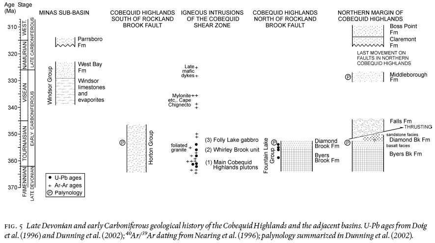
Display large image of Figure 5
25 The Falls Formation, consisting of poorly sorted conglomerate and coarse sandstone (Ryan et al. 1987), unconformably overlies the Diamond Brook Formation and rocks tentatively correlated with the Nuttby Formation within the New Annan Thrust zone. The Falls Formation is older than the late Vis. Middleborough Formation (Chandler et al. 1994) and younger than the mid-Tournaisian Diamond Brook Formation (Piper and Pe-Piper 2001). It is lithologically correlated with coastal outcrops of previously unnamed conglomerate east of Squally Point (Salas 1986) that unconformably overlies the Fountain Lake Group and contains deformed granite clasts. Sparse inland outcrops north of Advocate of similar conglomerate are also assigned to the Falls Formation.
26 Outliers of Westphalian Cumberland Group rocks are found locally in the western Cobequid Highlands between Port Greville and Cape Chignecto, including an area identified by Donohoe and Wallace (1982) at De Wolfe Brook, where the rocks lithologically and biostratigraphically correlate with the Polly Brook Formation of Ryan et al. (1991). The distribution of Cumberland Group rocks along the northern margin of the Cobequid Highlands has been mapped by Ryan et al. (1990a, b, c) and Ryan and Boehner (1990).
Late Devonian — Early Carboniferous plutonic rocks
27 Much of the Cobequid Highlands is underlain by plutonic rocks of latest Devonian to earliest Carboniferous age. The main plutonic rock types are granite and gabbro/diorite. In places, the felsic and mafic rocks appear to have been emplaced as co-existing magmas (Pe-Piper et al. 1996b) or as sheet-like alternations. Hybrid granitic/mafic rocks show mingling but incomplete mixing, whereas granodiorite/tonalite has been interpreted to result from complete mixing of the two magmas (Pe-Piper et al. 1996b). Large gabbro/diorite plutons contain variable amounts of granite in irregular patches and dykes. Donohoe and Wallace (1982) proposed a number of informal names for the plutons; we generally follow this nomenclature, but use the term "Wentworth Pluton" (Fig. 2) for the composite pluton previously known as the Folly Lake and Hart Lake-Byers Lake plutons, because of the genetic relationship between the two rock units and the impossibility of mapping the complex contact between them.
28 Three phases of pluton emplacement are recognised (Table 1 and Fig. 5):
- The main phase of plutonism in the Cobequid Highlands includes granite plutons of the western Cobequid Highlands and their associated gabbro (Pe-Piper 1996; Koukouvelas et al. 1996), the principally mafic Wyvern Pluton, and the granite in the northern part of the Wentworth Pluton (the Hart Lake - Byers Lake pluton of Donohoe and Wallace 1982). These units have all yielded ages of 362 to 358 Ma by U-Pb on zircon (Doig et al. 1996) or by 40Ar/39Ar on amphibole (Nearing et al. 1996) (Fig. 5). The emplacement of these plutonic rocks thus straddles the Devonian—Carboniferous boundary. The granitic Gilbert Hills pluton in the north central Cobequid Highlands is probably of similar age. Detailed descriptions of the Cape Chignecto Pluton are given by Pe-Piper et al. (1989) and Waldron et al. (1989), the Hanna Farm Pluton by Pe-Piper and Turner (1988b), the West Moose River Pluton by Pe-Piper et al. (1991), the North River Pluton by Pe-Piper (1991), the Wyvern and Gilbert Hills plutons by Pe-Piper et al. (1994), the Pleasant Hills Pluton by Pe-Piper et al. (1998), and the Wentworth Pluton by Pe-Piper (1998) and Koukouvelas et al. (2002).
- The Whirley Brook intrusion, a complex body made up of sheets of fine-grained granite and granitic porphyry, located between the northeastern Wentworth pluton and the Byers Brook Formation (Fig. 2). Irregular enclaves and sheets of diabase occur within this fine-grained granite, with textures suggesting that the mafic magma was immiscible (cf. Pe-Piper et al. 1996b). The Whirley Brook intrusion is marked by a strong magnetic anomaly (Piper et al. 1993), suggesting the presence of voluminous mafic rocks at shallow depth. The granitic rocks have a high Zr content, similar to distinctive high-Zr rhyolite found only at the extreme top of the Byers Brook Formation (Piper et al. 1999), with an inferred age of about 355 Ma (earliest Carboniferous).
- Gabbro/diorite of the southwestern Wentworth Pluton (Koukouvelas et al. 2002), termed the Folly Lake pluton by Donohoe and Wallace (1982). These rocks consistently yield 40Ar/39Ar ages on amphibole and biotite of 350—354 Ma (Nearing et al. 1996), dating from the early Carboniferous and synchronous with the extrusion of the voluminous basalt of the Diamond Brook Formation (Fig. 5). Much of the granite of the Wentworth pluton within a few kilometres of the Folly Lake gabbro either cross-cuts the gabbro or shows textures indicating the co-existence of immiscible mafic and felsic magmas (Pe-Piper et al. 1996b, Koukouvelas and Pe-Piper 1995, 1996). Koukouvelas et al. (2002) argued on the basis of textural, geochemical and radiometric data that these transition zone granites were the consequence of melting of "early" Hart Lake - Byers Lake granite by the Folly Lake gabbro/diorite.
29 Minor late units of the plutons consist principally of dykes of porphyritic rhyolite and diabase. Some felsic dykes have yielded U-Pb zircon ages of 356 Ma (Dunning et al. 2002); some mafic dykes appear to be as young as 328 Ma (Nearing et al. 1996). Abundant gabbro and diabase dykes occur south of Squally Point cutting Fountain Lake Group (Piper et al. 1993). South of the Rockland Brook Fault, gabbro sills make up perhaps 50% of the section in the Nuttby Formation and intrusive pods of gabbro are common in the Neoproterozoic rocks westward to Folly River. The age of these abundant mafic intrusions is not well constrained, but they probably correlate with basalt in the upper Horton Group of Prince Edward Island (Pe-Piper and Piper 1998b; Dunning et al. 2002), or with early Vis. gabbro dated at 338 Ma at St Peters in southern Cape Breton Island (Barr et al. 1994). There was also widespread mylonitization and alteration of biotite in the Cape Chignecto pluton at about this time (Nearing et al. 1996) (Fig. 5). There is no geochemical or petrological evidence for any dykes of Jurassic age among the 100 dykes for which we have geochemical analyses (Piper et al. 1996; Pe-Piper and Piper 1998b).
30 Regional magnetic (Kiss et al. 1989; Piper et al. 1993) and gravity (Mazzocco 1996) data suggest that plutonic rocks extend south of the Cobequid Fault. At Clark Head, near Parrsboro, blocks of Devonian—Carboniferous gabbro-granulite outcrop in a melange variously interpreted as a fault breccia (Donohoe and Wallace 1985, p. 50—53; Gibbons and Murphy 1995; Gibbons et al. 1996) or the cap rock on a Carboniferous evaporitic diapir (R.K. Stevens, personal communication, 1998). Seismic-reflection profiles show basement rocks dipping southward beneath Carboniferous sedimentary rocks for several kilometres south of the Cobequid Fault.
GEOCHEMICAL EVOLUTION OF THE DEVONIAN — CARBONIFEROUS PLUTONS AND VOLCANIC ROCKS
31 The basalt of the Diamond Brook Formation geochemically resembles continental flood basalts, with iron-enrichment and other geochemical features indicating derivation from plume-related melting in the asthenosphere, modified by passage through sub-continental lithospheric upper mantle (Dessureau et al. 2000). Gabbro intrusions of the Cobequid Shear Zone are of olivine tholeiite composition and appear geochemically related to the basalt. The granite plutons are subalkaline to alkaline with the geochemical character of A-type granite (Pe-Piper et al. 1991). Nd and Pb isotope data show that all the Cobequid Shear Zone granites appear derived from melting of crust compositionally similar to Neoproterozoic granodiorite (Pe-Piper and Piper 1998b).
32 The Wentworth pluton has higher alkalinity and lower aluminum saturation index than other granites of the Cobequid Shear Zone and its high Zn content suggests that it is probably richer in F than the other granites (Koukouvelas et al. 2002). All these features imply anhydrous melting of lower crust. The presence of the voluminous Folly Lake gabbro with its associated gravity anomaly and the unusually thick coeval basalt and felsic pyroclastic rocks near the Wentworth pluton both suggest the presence of a major heat source in this area, which resulted in more anhydrous melting here than elsewhere in the Cobequid Shear Zone. Along most of the Cobequid Shear Zone, the latest Devonian partial melting of lower crust to form granitic magma under more hydrous conditions was synchronous with development of Horton Group basins and was probably triggered by ingress of voluminous water from lakes through crustal-scale faults of the shear zone (Pe-Piper et al. 1998). Rhyolite of the Fountain Lake Group is geochemically similar to the granites (Pe-Piper et al. 1991; Piper et al. 1999).
STRUCTURE OF THE LATE PALEOZOIC COBEQUID SHEAR ZONE
33 The Cobequid Shear Zone, exposed throughout the Cobequid Highlands horst, consists of late Paleozoic, crustal scale, south-dipping, strike-slip faults developed during amalgamation of the Avalon and Meguma terranes (Donohoe and Wallace 1982, 1985; Miller et al. 1995; Durling 1996; Murphy and Keppie 1998). These faults were active during latest Devonian to earliest Carboniferous pluton intrusion and are cut by the younger Cobequid Fault, which experienced major late Carboniferous right-lateral strike-slip motion under brittle conditions (Murphy et al. 1999) and several kilometres of Triassic dip-slip motion (Withjack et al. 1995). The Rockland Brook fault is in part a reactivated Neoproterozoic shear zone between the Bass River and Jeffers blocks (Pe-Piper et al. 2002) that involved amphibolite facies metamorphism of mafic volcanic rocks as late as 589 Ma. This Neoproterozoic lineament was reactivated in the central Cobequid Highlands, but not in the extreme eastern Cobequid Highlands, where late Paleozoic motion was taken up on the Cobequid and Millsville faults (Fig. 2) (Pe-Piper et al. 2002). The Cobequid Fault may in part follow another Neoproterozoic lineament between the Bass River block and the Economy River gneiss.
34 Well exposed latest Devonian — earliest Carboniferous plutons occur along two dextral fault strands and an en echelon transition zone between them in the southern part of the Cobequid Shear Zone. The Kirkhill Fault strand is a fault 60 km long, now truncated at its western end by Triassic basin margin faults. On its northern side is the large Cape Chignecto pluton in the west and a series of smaller plutons to the east. The 60-km-long Rockland Brook Fault strand (Miller et al. 1995) merges at its western end with the younger Cobequid Fault and in its central portion dips about 45°S (Durling 1996). Almost all the Rockland Brook Fault shows intense magmatic activity, with the large Wentworth pluton north of the central part of the fault (Koukouvelas et al. 2002) and the smaller Pleasant Hills pluton at its western end (Pe-Piper et al. 1998). Between these two prominent faults, in the transition zone, the deformation was accommodated by several faults including two shear zones within the western Pleasant Hills Pluton (Pe-Piper et al. 1998), a fault along the southern margin of the North River Pluton, and the fault along the southern margin of the West Moose River Pluton. Significant ductile slip took place on all these faults in the latest Devonian — earliest Carboniferous, associated with NW-vergent thrusting and some wrench faulting (Koukouvelas et al. 1996), and space for pluton emplacement was created by the thrusting and wall-rock compression (Waldron et al. 1989; Piper et al. 1996a; Koukouvelas et al. 1996) and by lateral translation of blocks within the shear zones (Pe-Piper et al. 1998; Koukouvelas et al. 2002). Along the major fault zones, highly deformed earlier emplaced plutonic rocks underwent strong solid-state deformation and are cut by progressively less deformed younger plutonic rocks, demonstrating that the faults were persistent conduits for magma (Pe-Piper et al. 1998; Koukouvelas et al. 2002). In contrast to Donohoe and Wallace (1985, p. 18), we do not interpret the Rockland Brook fault as having truncated a previous larger Wentworth Pluton: rather, it was the master fault of a series of fault conduits for magma that were active during pluton emplacement (Koukouvelas et al. 2002). Although most plutons occur north of the Rockland Brook fault, the small Gain Brook granitic pluton and an un-named granitic body south of Earltown intrude the Bass River block (Pe-Piper et al. 2002). The fault-bound northern margin of the Cobequid Highlands, with minor overstep of upper Carboniferous rocks of the Cumberland Basin, is marked by the Spicer Cove Fault in the western Cobequid Highlands (Ryan et al. 1990a) and by a series of E—W faults in the eastern highlands (Durling 1996). The Spicers Cove fault appears to have been important in controlling the location of the poorly exposed Wyvern and Gilbert Mountain plutons (Fig. 2).
35 The Rockland Brook - Kirkhill fault system in general marks the boundary between well developed Nuttby Formation to the south and thick Fountain Lake Group to the north. The only Nuttby Formation to the north outcrops along the general trend of the fault system at the northern edge of the Pleasant Hills pluton and in the allochthonous New Annan thrust sheet (Piper and Pe-Piper 2001). Both biostratigraphic and radiometric data (Dunning et al. 2002) indicate that the Nuttby Formation and the Fountain Lake Group are essentially of the same age — late Famennian to middle Tournaisian (ca. 362 to 354 Ma) (Fig. 5). The lack of volcanic rocks in the Nuttby Formation suggests that either there has been major N—S shortening across the Cobequid Highlands and/or that major strike slip motion along the Cobequid Shear Zone took place after the end of voluminous volcanism in the mid Tournaisian (ca. 354 Ma).
36 North-vergent thrusting (the New Annan Thrust) of late Tournaisian age (ca. 350 Ma) is recognised in the northeastern Cobequid Highlands (Fig. 2) (Piper et al. 1996b; Piper and Pe-Piper 2001), postdating thrusting associated with pluton emplacement (Fig. 5). Possibly synchronous thrusting occurred north of Cape Chignecto (Waldron et al. 1989), where late dykes occupy thrust fault planes (Piper et al. 1993). Mylonite and secondary biotite from the Kirkhill fault trend in the Cape Chignecto pluton date from the early Vis. (336—339 Ma; Nearing et al. 1996) (Fig. 5). Mid-Namurian deformation is indicated by the unconformity of the Parrsboro Formation over the West Bay Formation south of the Cobequid Fault (Donohoe and Wallace 1985) (Fig. 5). The abundance of granite clasts in the late Namurian Claremont Formation north of the Millsville Fault suggests that major unroofing of the Gunshot Brook Pluton took place at that time (Piper and Pe-Piper 2001). Strongly deformed Nuttby Formation, for example near the Cape Chignecto Pluton, shows steep tight folds typical of shear zone deformation that probably was synchronous with the Vis. and possibly Namurian deformation recorded elsewhere.
37 At the southern margin of the Cobequid Highlands, widespread brittle strike-slip movement took place on E—W trending faults in the late Carboniferous (e.g., Donohoe and Wallace 1985, p. 38; Murphy et al. 1995, 1999), continuous with strike-slip in southern New Brunswick (Nance 1987) and the Stellarton Basin (Yeo and Gao 1987). The last significant motion on faults in the northern Cobequid Highlands was predominantly dip slip prior to deposition of the onlapping undeformed late Namurian Boss Point Formation (Piper and Pe-Piper 2001) (Fig. 5). Faults at a high angle to the E—W master faults generally appear to terminate against them, although in places there may be NNW-trending faults that offset these major faults. Some N—S faults of inferred earliest Carboniferous age appear to terminate against plutons (cf. Pe-Piper et al. 1998), others cut the Falls Formation but not late Carboniferous rocks (Piper and Pe-Piper 2001), and along the Cobequid Fault some N—S faults appear to be of Mesozoic age (Donohoe and Wallace 1985).
38 Renewed sinistral movement on the Cobequid-Chedabucto fault zone in the Triassic (Withjack et al. 1995) was associated with formation of the Fundy graben. Dextral motion offset the early Jurassic North Mountain Basalt along the Garish Mountain Fault (Donohoe and Wallace 1985, p.42) and thrust Windsor Group over North Mountain Basalt at Clark Head (Donohoe and Wallace 1985, p. 52) (Fig. 2), likely in the mid Cretaceous, but possibly in the Oligocene (Pe-Piper and Piper, unpublished report).
CONCLUSIONS
39 Neoproterozoic rocks of the Cobequid Highlands have a complex history. Volcanic rocks and turbidite of the Jeffers block were deformed in a strike-slip regime between 630 Ma and 605 Ma, with the intrusion of granodiorite and granite. The Jeffers block, which most closely resembles the Antigonish Highlands, shows a major shear zone contact, probably synchronous with the 605 Ma Gunshot Brook Pluton, with the Bass River block, which formed in a more inboard position on the Gondwanan margin. In the Bass River block, (?) middle Neoproterozoic shelf (Gamble Brook Formation) and oceanic basin (Folly River Formation) units were tectonically juxtaposed and deformed in a transpressional setting before and during intrusion of gabbro and granodiorite plutons from 622—607 Ma. Unlike other blocks or terranes in eastern Canadian Avalonion, the Bass River block lacks volcanic rocks synchronous with Late Neoproterozoic plutons, suggesting that it represents a deeper crustal level. Also unlike other parts of the eastern Canadian Avalonian, Cambrian - Ordovician shelf sedimentary rocks are not known from the Cobequid Highlands.
40 Silurian and Early Devonian shelf sedimentary rocks are widespread and of uniform facies over much of the Jeffers Block. In contrast, later Devonian and earliest Carboniferous strata comprise terrestrial sedimentary rocks and bimodal volcanic rocks that accumulated in smaller basins. This change in paleogeography resulted from the "Acadian orogeny", but clear evidence for "Acadian" deformation is lacking. Rather, there was progressive deformation in the Cobequid Shear Zone, developed along the Minas Geofracture during the convergence of the Avalon and Meguma terranes. A series of granitic plutons with minor gabbro were emplaced in the Cobequid Shear Zone between 362—358 Ma and record progressive dextral transpression with north-vergent thrusting in the shear zone. A little later, at ca. 354 Ma, voluminous gabbro was emplaced in the southwestern part of the Wentworth Pluton. The Fountain Lake Group represents the extrusive equivalent of this plutonism. It was synchronous with sedimentation of the Nuttby Formation (Horton Group) south of the Rockland Brook - Kirkhill fault system. These two contrasting formations imply original deposition in distant basins now juxtaposed by thrusting and strike-slip motion. Brittle strike-slip deformation and thrusting continued through to late Namurian in the northern Cobequid Highlands. In the south, there was also significant Westphalian and Mesozoic reactivation of the Cobequid and nearby faults.
ACKNOWLEDGEMENTS
Geological work in the Cobequid Highlands was principally funded by NSERC grants to G. Pe-Piper, accelerated at times by funding from Canada-Nova Scotia Mineral Development Agreements, and mapping was completed with contributions from Geological Survey of Canada A-base and NATMAP funding. We acknowledge the work of Denise Turner, Mary Feetham, Jason Goulden, Jerry deWolfe and Robbie Bennett in fieldwork and the assembly of both maps and the Fieldlog database. The following students also assisted in the field or laboratory: Marion Blank, Anthony Bond, Fred Boner, Steve Clerk, Gilles Dessureau, Craig Doucette, Liz Hilton, Rob Hubley, Andrew MacDonald, Joe Nearing, Dave Pass, Julie Selway, and Marg Zeeman, all of whom completed honours theses, and Debbra Wilkinson, Terry Coughlan, Herbie McDaniel, Jeff Chinn, Patricia LeBlanc, Howard Pancura, Kathryn Parlee, Derek Robichaud, Geoff Davies, Gayle Chapman, Calvin Campbell, and Tracie Quinlan. We thank our colleagues Iannis Koukouvelas, Brendan Murphy, John Waldron, Howard Donohoe, Damian Nance, Steve McCutcheon and Bob Stevens for fruitful discussions in the field and Howard Donohoe and Peter Giles for encouragement. This manuscript was improved by reviews by Rob Fensome, Peter Giles, Sandra Barr, Brendan Murphy, and in particular by Howard Donohoe.REFERENCES
Barr, S.M., & White, C.E. 1996. Contrasts in late Precambrian — early Paleozoic tectonothermal history between Avalon composite terrane sensu stricto and other possible peri-Gondwanan terranes in southern New Brunswick and Cape Breton Island, Canada. Geological Society of America Special Paper 304, pp. 95—108.
Barr, S.M., Grammatikopoulos, A.L., & Dunning, G.R.1994. Early Carboniferous gabbro and basalt in the St. Peters area, southern Cape Breton island, Nova Scotia. Atlantic Geology, 30, pp. 247—258.
Blank, M.E. 1985. The Geology of the Davidson Brook area, Cobequid Hills, Nova Scotia. B.Sc. honours thesis, Saint Mary's University, 87 p.
Bond, A. 1999. The petrology and geochemistry of iron-oxide deposits within the Cobequid Highlands, Nova Scotia. B.Sc. honours thesis, Saint Mary's University, 81 p.
Boner, F.J. 1985. The Geology of the North River area, Cobequid Highlands, Nova Scotia. B.Sc. honours thesis, Saint Mary's University, 83 p.
Chandler, F.W., Gall, Q., Gillis, K., Naylor, R., & Waldron, J. 1994. A progress report on the geology of the Stellarton Gap, Nova Scotia, including the Stellarton Coal Basin. Geological Survey of Canada Paper 94-1D, pp. 113—122.
Clerk, S.B. 1987. The petrology and geochemistry of the West Moose River Pluton, Cumberland County, Nova Scotia. B.Sc. honours thesis, Saint Mary's University, 208 p.
Cullen, M.P. 1984. Geology of the Bass River complex, Cobequid Highlands, Nova Scotia. M.Sc. thesis, Dalhousie University, Halifax, Nova Scotia, 183 p.
Dessureau, G. 1998. The petrology and geochemistry of an anorthosite suite, Cobequid Highlands, Nova Scotia. B.Sc. honours thesis, Saint Mary's University, 68 p.
Dessureau, G., Piper, D.J.W., & Pe-Piper, G. 1999. Geochemical evolution of earliest Carboniferous continental tholeiitic basalts along a crustal-scale shear zone, southwestern Maritimes Basin, eastern Canada. Lithos, 50, pp. 27—50.
Doig, R., Murphy, J.B., & Nance, R.D. 1991. U-Pb geochronology of Late Proterozoic rocks of the eastern Cobequid Highlands, Avalon Composite Terrane, Nova Scotia. Canadian Journal of Earth Sciences, 28, pp. 504—511.
Doig, R., Murphy, J.B., & Nance, R.D. 1993. Tectonic significance of the Late Proterozoic Economy River gneiss, Cobequid Highlands, Avalon Composite Terrane, Nova Scotia. Canadian Journal of Earth Sciences, 30, pp. 474—479.
Doig, R., Murphy, J.B., Pe-Piper, G., & Piper, D.J.W. 1996. U-Pb geochronology of late Paleozoic plutons, Cobequid Highlands, Nova Scotia, Canada: evidence for late Devonian emplacement adjacent to the Meguma-Avalon terrane boundary in the Canadian Appalachians. Geological Journal, 31, pp. 179—188.
Donohoe, H.V. 1982. Mineral occurrences in the Cobequid Highlands. Nova Scotia Department of Mines and Energy, Report 82-1, pp. 79—111.
Donohoe, H.V., & Wallace, P.I. 1979. The Portapique River section: a section through the Silurian to Lower Devonian. Nova Scotia Depart ment of Mines Report 79-1, pp. 151—161.
Donohoe, H.V. Jr., & Wallace, P.I. 1980. Structure and stratigraphy of the Cobequid Highlands, Nova Scotia. Geological Association of Canada - Mineralogical Association of Canada Joint Annual Meeting,Guidebook 19, Halifax, N.S., 64 p.
Donohoe, H.V., & Wallace, P.I. 1982. Geological map of the Cobequid Highlands, Nova Scotia. Scale 1:50 000. Nova Scotia Depart ment of Mines and Energy.
Donohoe, H.V. Jr., & Wallace, P.I. 1985. Repeated orogeny, faulting and stratigraphy of the Cobequid Highlands, Avalon Terrane of northern Nova Scotia. Geological Association of Canada - Mineralogical Association of Canada Joint Annual Meeting, Guidebook 3, Fredericton, N.B., 77 p.
Doucette, C. 1996. The petrology, geochemistry, mineralogy, and a detailed map of the felsic phases of the Wentworth plutonic complex, Cobequid Highlands, Nova Scotia. B.Sc. honours thesis, Saint Mary's University, 99 p.
Dunning, G., Barr, S., Giles, P.S., McGregor, D.C., Pe-Piper, G., & Piper, D.J.W. 2002. Chronology of Devonian to early Carboniferous rifting and igneous activity in southern Magdalen Basin based on U-Pb (zircon) dating. Canadian Journal of Earth Sciences, 39, pp. 1219—1237.
Durling, P. 1996. A seismic reflection study of the Fountain Lake Group in the Scotsburn Anticline area, northern Nova Scotia. Current research, 96-1D, pp. 47—53.
Eisbacher, G.H. 1967. Tectonic analysis in the Cobequid Mountains, Nova Scotia, Canada. Unpublished Ph.D. thesis, Princeton University, 108 p.
Eisbacher, G.H. 1969. Displacement and stress field along part of the Cobequid Fault, Nova Scotia. Canadian Journal of Earth Sciences, 6, pp. 1095—1104.
Eisbacher, G.H. 1970. Deformation mechanisms of mylonitic rocks and fractured granites in the Cobequid Mountains, Nova Scotia, Canada. Bulletin of the Geological Society of America, 81, pp. 2009—2020.
Ervine, W.B. 1994. Mineral occurrences along the Cobequid-Chedabucto fault system, Nova Scotia. Geological Survey of Canada Open File 2777, 503 pp.
Gaudette, H.E., Olszewski, W.J. Jr., & Donohoe, H.V. Jr. 1984. Rb/Sr isochrons of Precambrian age from plutonic rocks in the Cobequid Highlands, Nova Scotia. Nova Scotia Department of Mines and Energy Report 84-1A, pp. 285—292.
Gibbons, W., & Murphy, J.B. 1995. Mylonitic mafic granulite in fault megabreccia at Clarke Head, Nova Scotia: a sample of Avalonian lower crust? Geological Magazine, 132, pp. 81—90.
Gibbons, W., Doig, R., Gordon, T., Murphy, B., Reynolds, P., & White, J.C. 1996. Mylonite to megabreccia: tracking fault events within a transcurrent terrane boundary in Nova Scotia, Canada. Geology, 24, pp. 411—414.
Goulden, J.L. 1998. The origin of fluids producing barite and associated mineralization in the western Cobequid Highlands, Nova Scotia. B.Sc. honours thesis, Saint Mary's University, 56 p.
Hamblin, A.P. 1992. Half-graben lacustrine sedimentary rocks of the lower Carboniferous Strathlorne Formation, Horton Group, Cape Breton Island, Nova Scotia, Canada. Sedimentology, 39, pp. 263—284.
Hilton, E. 1998. Geochemistry and chemical mineralogy of mafic rocks of the Wentworth plutonic complex, Cobequid Highlands, Nova Scotia. B.Sc. honours thesis, Saint Mary's University, 94 p.
Hubley, R. 1987. The structure, petrology and geochemistry of the Frog Lake Pluton, Cobequid Highlands, Nova Scotia. B.Sc. honours thesis, Saint Mary's University, 131 p.
Kelley, D.G. 1966. Cobequid Mountains. In Report of Activities, May to October. Geological Survey of Canada Paper 66-1, pp. 172—173.
Keppie, J.D. 1982. The Minas geofracture. In Major structural zones and faults of the Northern Appalachians. Edited by P. St Julien and J. Beland. Geological Association of Canada, Special Paper 24, pp. 263—280.
Keppie, J.D., Dallmeyer, R.D., & Murphy, J.B. 1990. Tectonic implications of 40Ar/39Ar hornblende ages from late Proterozoic—Cambrian plutons in the Avalon composite terrane, Nova Scotia, Canada. Geological Society of America Bulletin, 102, pp. 516—528.
Keppie, J.D., Davis, D.W., & Krogh, T.E. 1998. U-Pb geo-chronological constraints on Precambrian stratified units in the Avalon Composite Terrane of Nova Scotia, Canada: tectonic implications. Canadian Journal of Earth Sciences, 35, pp. 226—236.
Kiss, F.G., Ready, E.E., Stone, P.E., & Tesky, D.J. 1989. Aeromagnetic total field, gradiometer and VLF-EM survey of the Cobequid Highlands, Nova Scotia. Geological Survey of Canada Paper 89-1B, pp. 1—5.
Koukouvelas, I., & Pe-Piper, G. 1995. The role of granites in the evolution of the Folly Lake diorite, Cobequid Highlands, Nova Scotia. Geological Survey of Canada Paper 95-1D, pp. 33—38.
Koukouvelas, I., & Pe-Piper, G. 1996. The Hart Lake-Byers Lake and Folly Lake plutons, Cobequid Highlands, Nova Scotia: deformation history inferred from mafic enclaves. Geological Survey of Canada Paper 1996-D, pp. 35—40.
Koukouvelas, I., Pe-Piper, G., & Piper, D.J.W. 1996. Pluton emplacement by wall-rock thrusting, hanging-wall translation and extensional collapse: latest Devonian plutons of the Cobequid fault zone, Nova Scotia, Canada. Geological Magazine, 133, pp. 285—298.
Koukouvelas, I., Pe-Piper, G., & Piper, D.J.W. 2002. The role of dextral transpressional faulting in the evolution of an early Carboniferous mafic-felsic plutonic and volcanic complex: Cobequid Highlands, Nova Scotia, Canada. Tectonophysics, 348, pp. 219—246.
Lynch, G., Giles, P.S., Deblonde, C., Barr, S.M., Piper, D.J.W., St. Peter, C., Hetu, R.J., Johnson, S.C., Pe-Piper, G., St-Jean, R., Murphy, J.B., Chandler, F.W., & Boehner, R.C. 1998.
Magdalen Basin NATMAP - Onshore Geological Database. 1 CD-ROM, Geological Survey of Canada Open File D3564.
MacDonald, A. 1984. The geology of the Jeffers Brook area, Cobequid Highlands, Nova Scotia. B.Sc. honours thesis, Saint Mary's University, 59 p.
Martel, A.T., McGregor, D.C., & Utting, J. 1993. Stratigraphic significance of Upper Devonian and Lower Carboniferous miospores from the type area of the Horton Group, Nova Scotia. Canadian Journal of Earth Sciences, 30, pp. 1091—1098.
Mazzocco, P. 1996. Gravity modelling of the Cobequid Highlands. Geological Survey of Canada (Atlantic), internal report. 73 p.
Meagher, C. 1995. Petrology of the Mount Thom Complex. B.Sc. Honours Thesis, Saint Francis Xavier University, 89p.
Miller, B.V., Nance, R.D., & Murphy, J.B. 1995. Kinematics of the Rockland Brook fault, Nova Scotia: implications for the interaction of the Meguma and Avalon terranes. Journal of Geodynamics, 19, pp. 253—270.
Murphy, J.B. 2000. Tectonic influence on sedimentation along the southern flank of the late Paleozoic Magdalen basin in the Canadian Appalachians: Geochemical and isotopic constraints on the Horton Group in the St. Marys basin, Nova Scotia. Geological Society of America Bulletin, 112, pp. 997—1011.
Murphy, J.B. 2002. Geochemistry of the Neoproterozoic metasedimentary Gamble Brook Formation, Avalon Terrane, Nova Scotia: evidence for a rifted-arc environment along the west Gondwanan margin of Rodinia. Journal of Geology, 110, pp. 407—419.
Murphy, J.B., & Keppie, J.D. 1998. Late Devonian palinspastic reconstruction of the Avalon-Meguma terrane boundary: implications for terrane accretion and basin development in the Appalachian orogen. Tectonophysics, 284, pp. 221—231.
Murphy, J.B., & Rice, R.J. 1998. Stratigraphy and depositional environment of the Horton Group in the St Marys Basin, central mainland Nova Scotia. Atlantic Geology, 34, pp. 1—25.
Murphy, J.B., Pe-Piper, G., Nance, R.D., & Turner, D.S. 1988. Geology of the eastern Cobequid Highlands: a preliminary report. In: Current Research, Part B, Geological Survey of Canada Paper 88-1B, pp. 99—107.
Murphy, J.B., Keppie, J.D., & Hynes, A.J. 1991. Geology of the northern Antigonish Highlands, Nova Scotia. Geological Survey of Canada Paper 89-10, 114 p.
Murphy, J.B., Pe-Piper, G., Keppie, J.D., & Piper, D.J.W. 1992. Correlation of Neoproterozoic III sequence in the Avalon Composite Terrane of mainland Nova Scotia: tectonic implications. Atlantic Geology, 28, pp. 143—151.
Murphy, J.B., Rice, R.J., Stokes, T.R., & Keppie, J.D. 1995. The St Marys Basin, central mainland Nova Scotia: Late Paleozoic basin formation and deformation along the Avalon-Meguma terrane boundary, Canadian Appalachians. In New Perspectives in the Caledonian - Appalachian orogen, Edited by J. Hibbard, C. van Staal and P. Cawood. Geological Association of Canada Special Paper 41, pp. 409—420.
Murphy, J.B., Keppie, J.D., Davis, D., & Krogh, T.E. 1997. Regional significance of new U-Pb age data for Neoproterozoic igneous units in Avalonian rocks of northern mainland Nova Scotia, Canada. Geological Magazine, 134, pp. 113—120.
Murphy, J.B., Keppie, J.D., & Nance, R.D. 1999. Fault reactivation within Avalonia: plate margin to continental interior deformation. Tectonophysics, 305, pp. 183—204.
Murphy, J.B., Pe-Piper, G., Piper, D.J.W., Nance, R.D., & Doig, R. 2001. Geology of the Eastern Cobequid Highlands. Geological Survey of Canada Bulletin 556, 61 p.
Nance, R.D. 1987. Dextral transpression and Late Carboniferous sedimentation in the Fundy coastal zone of southern New Brunswick. Canadian Society of Petroleum Geologists, Memoir 12, pp. 363—377.
Nance, R. D., & Murphy, J. B. 1990. Kinematic history of the Bass River Complex, Nova Scotia: Cadomian tectonostrati-graphic relations in the Avalon terrane of the Canadian Appalachians. Geological Society Special Paper 51, pp. 395—406.
Nance, R.D., Murphy, J.B., & Keppie, J.D. 2002. A Cordilleran model for the evolution of Avalonia. Tectonophysics, 352, pp. 11—31.
Nearing, J. 1992. Early Carboniferous hydrothermal events of the western Cobequid Highlands, Nova Scotia. B.Sc. honours thesis, Saint Mary's University, 86 p.
Nearing, J.D., Reynolds, P.H., & Pe-Piper, G. 1996. Devonian—Carboniferous 40Ar/39Ar thermochronology of the Cobequid Highlands, Nova Scotia. Geological Association of Canada/Mineralogical Association of Canada, Annual Meeting Abstracts, 22, p. 108.
Pass, D.J 1993. Late Paleozoic volcanic stratigraphy and structural history of Squally Point and vicinity, western Cobequid Highlands, Nova Scotia. B.Sc. honours thesis, Saint Mary's University, 88 p.
Pe-Piper, G. 1988. Calcic amphiboles of mafic rocks of the Jeffers Brook plutonic complex, Nova Scotia, Canada. American Mineralogist, 73, pp. 993—1006.
Pe-Piper, G. 1991. Granite and associated mafic phases, North River pluton, Cobequid Highlands. Atlantic Geology, 27, pp. 15—28.
Pe-Piper, G. 1996. The Carboniferous plutons and associated igneous rocks of the western Cobequid Highlands, Nova Scotia. Geological Survey of Canada Open File Report 3252, 89 p., 6 colour maps.
Pe-Piper, G. 1998. The Devonian—Carboniferous Wentworth plutonic complex (Folly Lake and Hart Lake - Byers Lake Plutons) of the central Cobequid highlands, Nova Scotia. Geological Survey of Canada Open File Report 3373, 87 p. + CD-ROM.
Pe-Piper, G. 2001. The Devonian—Carboniferous North River and Gilbert Mountain plutons, Cobequid Highlands, Nova Scotia. Geological Survey of Canada Open File Report 3874. Pe-Piper, G., & Dessureau, G. 2002. The West Moose River anorthosites, Avalon zone, Nova Scotia. Geological Survey of Canada Open File Report 4188.
Pe-Piper, G., & Murphy, J.B. 1989. Petrology of the Late Proterozoic Folly River Formation, Cobequid Highlands, Nova Scotia: a continental rift within a volcanic arc environment. Atlantic Geology, 25, pp. 143—151.
Pe-Piper, G., & Piper, D.J.W. 1987. The Pre-Carboniferous rocks of the western Cobequid Hills, Avalon zone, Nova Scotia. Maritime Sediments and Atlantic Geology, 23, pp. 41—48.
Pe-Piper, G., & Piper, D.J.W. 1989. The upper Hadrynian Jeffers Group, Cobequid Hills, Avalon Zone of Nova Scotia: a back-arc volcanic complex. Geological Society of America Bulletin, 101, pp. 364—376.
Pe-Piper, G., & Piper, D.J.W. 1998a. Geochemical and structural evolution of the Pleasant Hills pluton, Cobequid Highlands, Nova Scotia, Canada. Geological Survey of Canada Open File Report 3372, 110 p. + CD-ROM.
Pe-Piper, G., & Piper, D.J.W. 1998b. Geochemical evolution of Devonian—Carboniferous igneous rocks of the Magdalen basin, Eastern Canada: Pb and Nd isotope evidence for mantle and lower crustal sources. Canadian Journal of Earth Sciences, 35, pp. 201—221.
Pe-Piper, G., & Turner, D.S. 1988a. The Jeffers Group, western Cobequid Hills, Nova Scotia. Geologi cal Survey of Canada Open File 1782, 90 p. and 4 maps.
Pe-Piper, G., & Turner, D.S. 1988b. The Hanna Farm pluton. Cobequid Highlands: petrology and significance for motion on the Kirkhill fault. Maritime Sediments and Atlantic Geology, 24, pp. 171—183.
Pe-Piper, G., Cormier, R.F., & Piper, D.J.W. 1989. The age and significance of Carboniferous plutons of the western Cobequid Hills, Nova Scotia. Canadian Journal of Earth Sciences, 26, pp. 1297—1307.
Pe-Piper, G., Piper, D.J.W., & Clerk, S.B. 1991. Persistent mafic igneous activity in an A-type granite pluton, Cobequid Highlands, Nova Scotia. Canadian Journal of Earth Sciences, 28, pp. 1058—1072.
Pe-Piper, G., Piper, D.J.W., Parlee, K., & Turner, D.S. 1994. Geology of the headwaters of the River Philip, Cobequid Highlands. Geological Survey of Canada Open file 2887, 34 p.
Pe-Piper, G., Piper, D.J.W., & Koukouvelas, I. 1995. Field evidence for the character of the Precambrian rocks south of the Rockland Brook fault, Bass River block, Cobequid Highlands. Geological Survey of Canada, Paper 95-1D, pp. 27—31.
Pe-Piper, G., Piper, D.J.W., & Koukouvelas, I. 1996a. Precambrian plutons of the Cobequid Highlands, Nova Scotia. Geological Society of America Special Paper 304, pp. 121—132.
Pe-Piper, G., Zeeman, M., & Piper, D.J.W. 1996b. Magmatic significance of the relationships between the mafic and felsic phases of the Folly Lake pluton, Cobequid Highlands, Nova Scotia. Geological Survey of Canada Paper 96-1E, pp. 27—33.
Pe-Piper, G., Koukouvelas, I., & Piper, D.J.W. 1998. Synkinematic granite emplacement in a shear zone: the Pleasant Hills pluton, Canadian Appalachians. Geological Society of America Bulletin, 110, pp. 523—536.
Pe-Piper, G., Piper, D.J.W., & Hilton, E. 2002. Neoproterozoic plutonic rocks of the eastern Cobequid Highlands, N.S., Canada. Geological Survey of Canada Open File Report 4189, 47 p.
Piper, D.J.W. 1994. Late Devonian — earliest Carboniferous basin formation and relationship to plutonism, Cobequid Highlands, Nova Scotia. Geological Survey of Canada Paper 94-1D, pp.109—112.
Piper, D.J.W., & Pe-Piper, G. 2001. Tournaisian thrusting in the northeastern Cobequid Highlands, Nova Scotia and its regional significance. Canadian Journal of Earth Sciences, 38, pp. 43—58
Piper, D.J.W., Pe-Piper, G., & Loncarevic, B.D. 1993. Devonian — Carboniferous deformation and igneous intrusion in the Cobequid Highlands. Atlantic Geology, 29, pp. 219—232.
Piper, D.J.W., Pe-Piper, G., & Pass, D.J. 1996a. The stratigraphy and geochemistry of late Devonian to early Carboniferous volcanic rocks of the northern Chignecto peninsula, Cobequid Highlands, Nova Scotia. Atlantic Geology, 32, pp. 39—52.
Piper, D.J.W., Durling, P., & Pe-Piper, G. 1996b. Field evidence for the extent and style of overthrusting along the northeastern margin of the Cobequid Highlands, Nova Scotia. Geological Survey of Canada Current Research Paper 1996-D, pp. 41—46.
Piper, D.J.W., Dessureau, G., & Pe-Piper, G. 1999. Occurrence of high-Zr rhyolites, early Carboniferous, Cobequid Highlands, Nova Scotia: temperature effect of a contemporaneous mafic magma. Canadian Mineralogist, 37, p. 619—634.
Ryan, R.J., & Boehner, R.C. 1990. Cumberland basin geology map, Tatamagouche and Malagash, Cumberland, Colchester and Pictou counties. Nova Scotia Department of Mines and Energy, Map 90-14, 1: 50 000 scale.
Ryan, R.J., Calder, J.H., Donohoe, H.V., & Naylor, R. 1987. Late Paleozoic sedimentation and basin development adjacent to the Cobequid Highlands massif, eastern Canada. Canadian Society of Petroleum Geologists, Memoir 12, pp. 311—317.
Ryan, R.J., Boehner, R.C., & Deal, A. 1990a. Cumberland basin geology map, Apple River and Cape Chignecto, Cumberland County. Nova Scotia Department of Mines and Energy, Map 90-11, 1: 50 000 scale.
Ryan, R.J., Boehner, R.C., Deal, A., & Calder, J.H. 1990b. Cumberland basin geology map, Amherst, Springhill and Parrsboro, Cumberland County. Nova Scotia Department of Mines and Energy, Map 90-12, 1: 50 000 scale.
Ryan, R.J., Boehner, R.C., & Deal, A. 1990c. Cumberland basin geology map, Oxford and Pugwash, Cumberland County. Nova Scotia Department of Mines and Energy, Map 90-13, 1: 50 000 scale.
Ryan, R.J., Boehner, R.C., & Calder, J.H. 1991. Lithostrati-graphic revisions of the upper Carboniferous to lower Permian strata in the Cumberland Basin, Nova Scotia and the regional implications for the Maritimes Basin in Atlantic Canada. Bulletin of Canadian Petroleum Geology, 39, pp. 289—314.
Salas, C.J. 1986. Braided fluvial architecture within a rapidly subsiding basin: the Pennsylvanian Cumberland Group southwest of Sand River, Nova Scotia. M.Sc. thesis, University of Ottawa, 351 p., 8 maps.
Selway, J. 1991. The petrology, geochemistry and a detailed map of the Pleasant Hills pluton in the Cobequid Highlands, Nova Scotia. B.Sc. honours thesis, Saint Mary's University, 179 p.
Tucker, R.D., Bradley, D.C., ver Straaten, C., Harris, A.J., Ebert, J.R., & McCutcheon, S.R. 1998. New U-Pb zircon ages and the duration and division of Devonian time. Earth and Planetary Science Letters, 158, pp. 175—186.
Utting, J., Keppie, J.D., & Giles, P.S. 1989. Palynology and stratigraphy of the Lower Carboniferous Horton Group, Nova Scotia. Geological Survey of Canada Bulletin 396, pp. 117—143.
Waldron, J.G.F., Piper, D.J.W., & Pe-Piper, G. 1989. Deformation of the Cape Chignecto Pluton, Cobequid Highlands, Nova Scotia: thrusting at the Meguma-Avalon boundary. Atlantic Geology, 25, pp. 51—62.
Withjack, M.O., Olsen, P.E., & Schlische, R.W. 1995. Tectonic evolution of Fundy basin, Canada: Evidence for extension and shortening during passive margin formation. Tectonics, 40, pp. 390—405.
Yeo, G., & Gao, R.-X. 1987. Stellarton graben: an upper Carboniferous pull-apart basin in northern Nova Scotia. Canadian Society of Petroleum Geologists, Memoir 12, pp. 299—309.
Zeeman, M. 1992. The petrology and geochemistry of the Folly Lake pluton and the contact relationships between the mafic and felsic phases, Cumberland and Colchester counties, Nova Scotia. B.Sc. honours thesis, Saint Mary's University, 105 p.
Editorial responsibility: Sandra M. Barr