Archived U-Pb (zircon) dates from southern New Brunswick
Malcolm J. McLeodNew Brunswick Department of Natural Resources and Energy, Geological Surveys Branch, P.O. Box 5040, Sussex, NB E4E 5L2, Canada
Susan C. Johnson
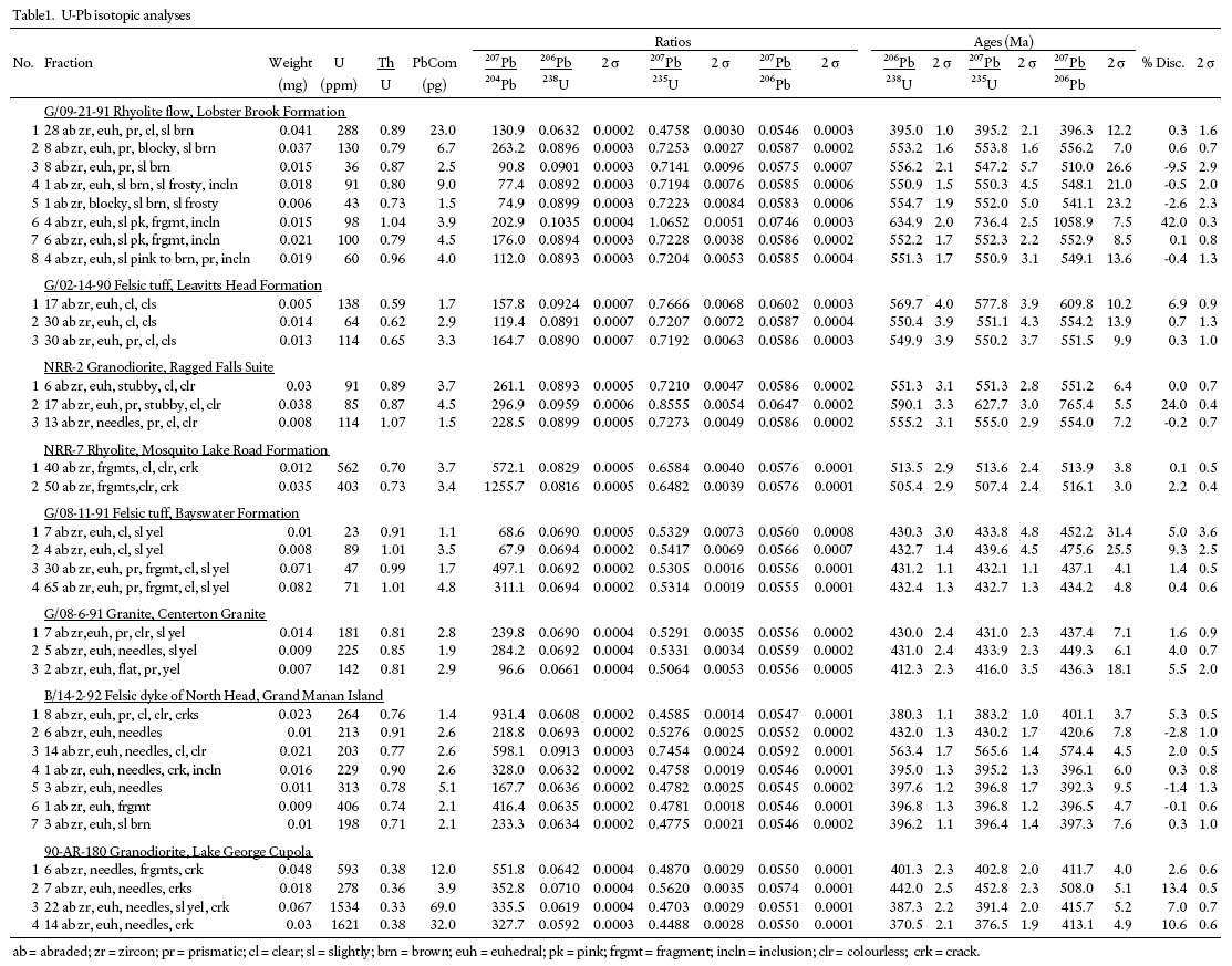
New Brunswick Department of Natural Resources and Energy, Geological Surveys Branch, P.O. Box 5040, Sussex, NB E4E 5L2, Canada
Tom E. Krogh
Department of Geology, Royal Ontario Museum, 100 Queens Park, Toronto, ON M5S 2C6, Canada
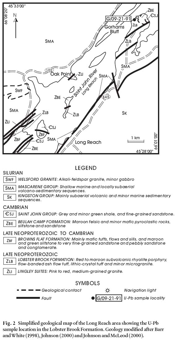
Date received: September 9, 2003 ¶ Date accepted: February 19, 2004
ABSTRACT
U-Pb (zircon) ages for eight samples from southern New Brunswick were determined during the early 1990's as part of a regional mapping and correlation program. Although most of the dates have been subsequently quoted in the literature through personal communications, and some preliminary isochron diagrams have been incorporated in papers, the results have not been published in their entirety. The units sampled and best estimates for their ages are the Lobster Brook Formation (554 ± 6 Ma), Leavitts Head Formation (554 ± 3 Ma), Ragged Falls Suite (553 ± 2 Ma), Mosquito Lake Road Formation (514 ± 2 Ma, maximum age), Bayswater Formation (436 ± 3 Ma), Centreton Granite (437 ± 3 Ma), felsic dyke of North Head, Grand Manan Island (396+3/-2 Ma), and Lake George Cupola, Lake George Mine (414 ± 2 Ma).RÉSUMÉ
Des datations au U-Pb (à partir de zircon) de huit échantillons du Sud du Nouveau-Brunswick avaient été réalisées au début des années 90 dans le cadre d'un programme régional de cartographie et de corrélation. Même si la majorité des dates ont subséquemment été citées dans de la documentation par le biais de communications personnelles et que certains schémas isochrones préliminaires ont été incorporés dans des communications, les résultats n'ont pas été publiés dans leur intégralité. Les unités échantillonnées et leur meilleurs âges estimatifs comprennent la Formation de Lobster Brook (554 ± 6 Ma), la Formation de Leavitts Head (554 ± 3 Ma), le cortège de Ragged Falls (553 ± 2 Ma), la Formation de Mosquito Lake Road (514 ± 2 Ma, âge maximal), la Formation de Bayswater (436 ± 3 Ma), le granite de Centreton (437 ± 3 Ma), le dyke felsique de North Head, dans l'île Grand Manan (396+3/-2 Ma), et la coupole du lac George, à la mine du lac George (414 ± 2 Ma).[Traduit par la rédaction]INTRODUCTION
1 U-Pb dating of problematic units was a critical component in the interpretation and production of regional bedrock geological compilation maps for southern New Brunswick (McLeod et al. 1994a, 1994b). Some of the U-Pb dates and related analytical data have been published in their entirety (McLeod et al. 1992; Ruitenberg et al. 1993), whereas others have been incompletely published as isochron diagrams (Johnson and McLeod 1996) or quoted as personal communications. The purpose of this paper is to present all dates and data for those not yet published in their entirety.
2 The main tectonostratigraphic subdivisions of southern New Brunswick (modified after Fyffe and Fricker 1987; Barr and White 1996; Johnson and McLeod 1996) and locations of more detailed maps for U-Pb sample localities are shown on Fig. 1. These belts have been variously assigned terrane and/or major zone status in the references cited above and in several subsequent publications concerning the geology of southern New Brunswick. However, these assignments remain contentious as discussed by Barr et al. (2001b). Consequently, interpretations of the dates in this paper, especially as pertain to terrane and zonal analysis, will not be too thorough except in some instances where such consideration is necessary to develop within-belt correlations. Also, references to major zonal subdivisions of the northern Appalachian orogen (e.g. the Avalon or Gander zones) are purposely omitted from Fig. 1, and avoided in the text.
3 Zircon grains were concentrated, prepared, and analyzed from 20 to 40 kg rock samples, following methods described by Krogh (1973, 1982). Analyses were conducted at the Royal Ontario Museum, Toronto, Canada. The U decay constants are after Jaffey et al. (1971) and data regressions were calculated according to Davis (1982). Errors are quoted at 95% (2 ó) confidence level unless otherwise stated. The isotopic data are presented in Table 1.
Fig. 1 Regional geology of southern New Brunswick and locations of more detailed maps.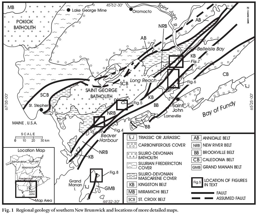
Display large image of Figure 1
Table1. U-Pb isotopic analyses
LOBSTER BROOK FORMATION
Geological setting
4 The Lobster Brook Formation crops out sporadically along the length of the Long Reach on the Saint John River and along Belleisle Bay in the northeastern part of the New River Belt (Figs. 1, 2). It comprises mostly red to pink rhyolite porphyry, felsic crystal-rich ash tuff, felsic lithic-crystal tuff and minor microgranite (Johnson 2001a, b). It is in fault contact against Late Neoproterozoic (ca. 625 Ma) granitoid rocks of the Lingley and Brittain Creek plutons to the north (Currie and McNicoll 1999). Contacts with stratigraphic units in the area are generally not exposed, but field relationships suggest that the Lobster Brook Formation is concordantly overlain by Latest Neoproterozoic to Early Cambrian felsic and minor mafic volcanic and sedimentary rocks of the Beulah Camp Formation, which are in turn overlain by Early Cambrian sedimentary rocks of the Saint John Group (Johnson 2001a, b). The Lobster Brook Formation is in fault contact against mafic volcanic and sedimentary rocks of the Browns Flat Formation. Although the Browns Flat Formation contains lithologies that are similar to those in the Beulah Camp Formation, its age and relationship to these rocks remain unclear as stratigraphic continuity with the rest of the sequence cannot be established (Johnson 2001a).
Fig. 2 Simplified geological map of the Long Reach area showing the U-Pb sample location in the Lobster Brook Formation. Geology modified after Barr and White (1998), Johnson (2000) and Johnson and McLeod (2000).Purpose of dating
5 At the time of this sampling program there was some debate as to whether the volcanic rocks, now assigned to the Lobster Brook, Beulah Camp, and Browns Flat formations, were Early Cambrian (e.g. Greenough et al. 1985; Johnson and McLeod 1996) or Latest Neoproterozoic age (Eocambrian of Currie 1988, 1989, 1992). A precise age for this sequence was considered important for regional correlations because the Cambrian-Ordovician section in southern New Brunswick (i.e. Saint John Group in the Caledonia Belt or Avalon terrane sensu stricto) is devoid of volcanic rocks and thought to have formed in a tectonically quiescent setting, although this interpretation has been challenged recently by Landing and Westrop (1998, pg. 6). The age of the volcanic-rich strata in the Long Reach area, therefore, had implications for plate tectonic interpretations pertaining to terrane affiliation and timing of terrane amalgamation in southern New Brunswick (Johnson and McLeod 1996). The Lobster Brook Formation in the Long Reach area was sampled in order to resolve this problem.
Sample description and results
6 Sample G/09-21-91 was collected from the Lobster Brook Formation on the northwestern shore of Gorhams Bluff on the north end of the small cove immediately south at the navigation light (Fig. 2). It consists of a dark red, undeformed and nonwelded, crystal-rich ash-flow tuff that is typical of the Lobster Brook Formation. The sample contains approximately equal proportions of broken and fractured quartz and potassium feldspar phenocrysts, and subordinate plagioclase crystals in a matrix of rounded, devitrified rhyolite fragments and crystal debris. Some of the feldspar and the matrix is variably sericitized and quartz veinlets occur sporadically.
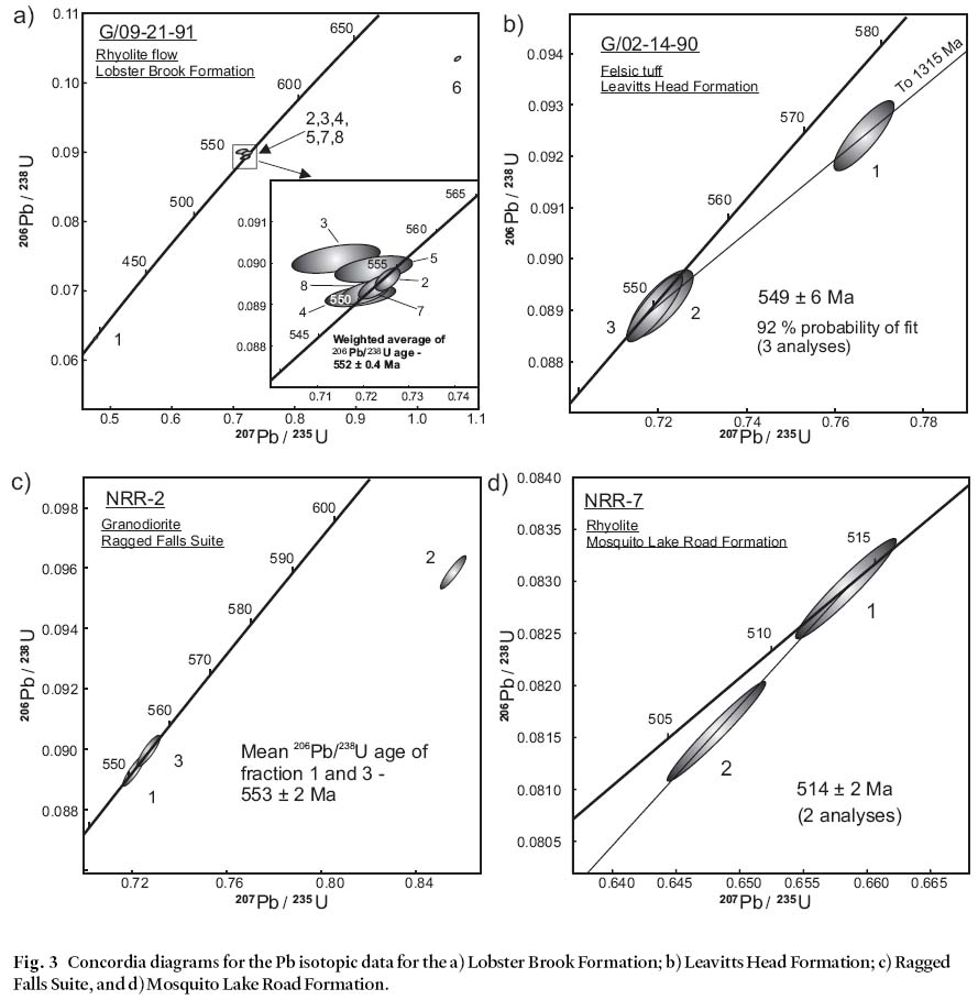
7 Abundant zircon grains in this sample are pale brown and euhedral with minor rounding, possibly due to resorption. A small percentage of grains are sharply-facetted and show less colour. A total of eight, multi- and single-grain analyses were conducted (Fig. 3a). Fractions 1 and 6 yield anomalous results (207Pb/206Pb ages of 397 ± 9 Ma and 1059 ± 5 Ma, respectively) due to contamination and/or Pb loss and to the presence of a much older grain(s), respectively. The high common Pb in fraction 1 suggests that alteration may be present. The remaining analyses form a cluster at 550 Ma and a regression line calculation through point 6 and the 550 Ma cluster of points gives an upper intercept age of 2383 Ma, a maximum age for the inherited component. The best estimate of the minimum age is the weighted average of the 206Pb/238U ages of the 550 Ma cluster of points, which is 552.0 ± 0.4 Ma. and Browns Flat formations as a whole comprise a bimodal,However, a line fixed at 10 Ma and fit through the most reliable volcanic and red bed sequence (Greenough et al. 1985;points (fractions 2, 4, 7, and 8) gives an upper intercept age of Johnson 2001b). Although not comprehensively character-554 ± 6 with an 88% probability of fit. This age is considered ized geochemically, available data indicate that these units inthe time of extrusion for these volcanic rocks.
Fig. 3 Concordia diagrams for the Pb isotopic data for the a) Lobster Brook Formation; b) Leavitts Head Formation; c) Ragged Falls Suite, and d) Mosquito Lake Road Formation.Discussion
8 The U-Pb age demonstrates that the Lobster Brook Formation is Late Neoproterozoic as originally suggested by Currie (1988, 1989, 1992). The Lobster Brook, Beulah Camp and Browns Flat formations as a whole comprise a bimodal, volcanic and red bed sequence (Greenough et al. 1985; Johnson 2001b). Although not comprehensively characterized geochemically, available data indicate that these units in the Long Reach area formed in an extensional tectonic setting (Greenough et al. 1985). This package in the northeastern part of the New River Belt is essentially coeval, and to some extent lithologically similar to units of rhyolite, rhyolitic tuff, basaltic tuff and flows, and red beds in the upper part of the Coldbrook Group in the Caledonia Belt, which also formed in an extensional tectonic setting as described by Barr et al. (1994) and Barr and White (1999). Further, as is common in the Caledonia Belt, the bimodal sequence in the Long Reach area is overlain concordantly by the Saint John Group. Consequently, Johnson (2001a, b), following Currie and McNicoll, postulated that the units in the Long Reach area are closely allied with the Caledonia Belt and may represent a segment of it. A geochemical sampling program currently being conducted may aid in assessing this contention.
LEAVITTS HEAD FORMATION
Geological setting
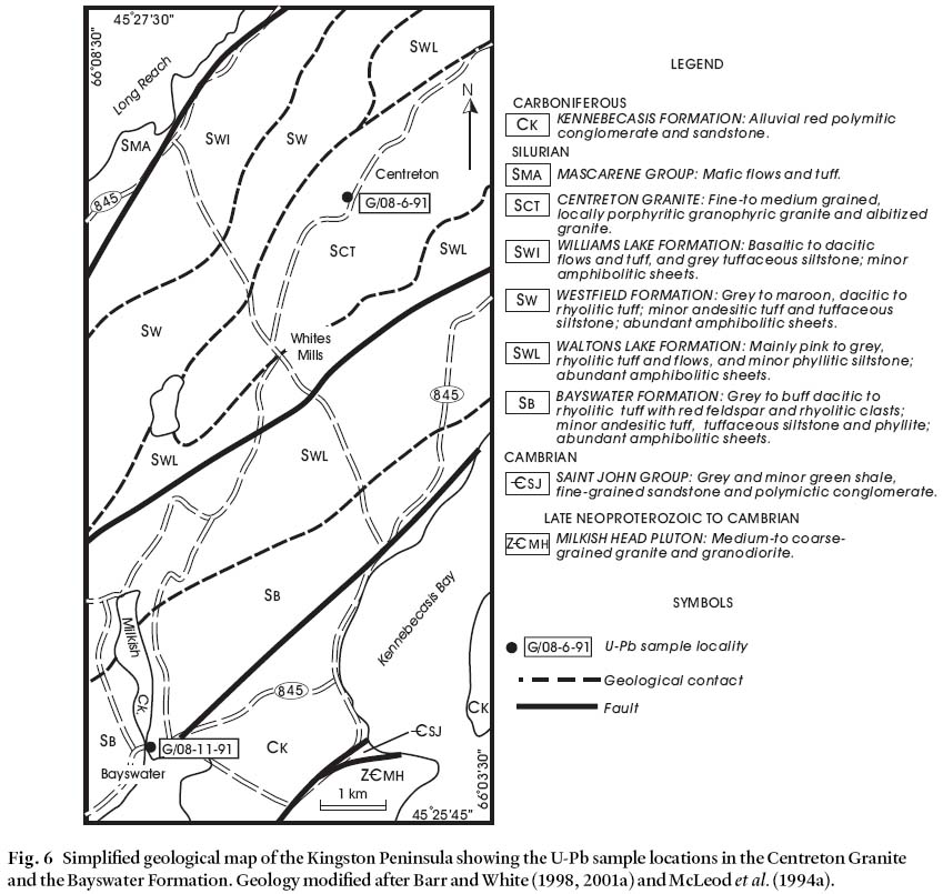
9 The Leavitts Head Formation comprises a sequence of interbedded, predominantly felsic and minor mafic tuffaceous rocks (McLeod 1995a) forming a narrow, northeast-trending unit in the western part of the New River Belt of Johnson (2001b) (Fig. 1, 4). To the south, the Letang Harbour Fault separates the formation from the Late Neoproterozoic Blacks Harbour Granite (Helmstaedt 1968; Currie 1988; Barr et al. 2002a, 2003) and intermediate to mafic volcanic rocks of the Simpsons Island Formation (McLeod 1995a). The latter were originally thought to be of Late Ordovician age (McLeod 1995a); however, recent U-Pb data indicate an earliest Cambrian age for the Simpsons Island Formation (Barr et al. 2002a, 2003). Although the contact is not exposed, the Pull and Be Damned Complex (Granite) of Currie (1988) is interpreted to intrude the Leavitts Head Formation to the north. Screens of felsic volcanic rocks similar in composition to the Leavitts Head Formation are incorporated in the granite north of the sample locality, and granitic dykes of the Pull and Be Damned Granite cut the formation along strike to the southwest (McLeod 1995a). Granitoid rocks similar to those in the Pull and Be Damned Granite occur at Ragged Falls on the Lepreau River and near New River, where they yielded a Late Neoproterozoic age of 555 ± 10 Ma (Currie and Hunt 1991; Johnson and McLeod 1996).
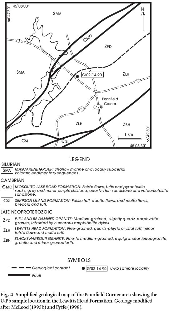
Fig. 4 Simplified geological map of the Pennfield Corner area showing the U-Pb sample location in the Leavitts Head Formation. Geology modified after McLeod (1995b) and Fyffe (1998).Purpose of dating
10 Historically, most felsic volcanic rocks in the western part of the New River Belt were assigned Silurian ages (e.g., Donohoe 1978). Based on the interpreted Late Neoproterozoic age of the Pull and Be Damned Granite, and the apparent intrusive relationship between the granite and some of these volcanic rocks in the vicinity of Pennfield Corner (e.g. Johnson and McLeod 1996), the Silurian age assigned to the latter was suspect. The sample was selected to verify the presence of Late Neoproterozoic volcanic rocks in this part of the New River Belt, with the aim to enhance correlations between major tec-tonostratigraphic belts in the region.
Sample description and results
11 Sample G/02-14-90 was collected from the north end of a 20 metre-long outcrop on the east side of Highway 1, about 1.5 kilometres north of Pennfield Corner (Fig. 4). The sample is a red to pink felsic tuff that is characteristic of the unit, and is composed of about 15% 1 to 2 mm-size clear quartz and minor potassium feldspar and plagioclase crystals in a completely recrystallized quartzo-feldspathic matrix. Coarser-grained recrystallized ovoids, which comprise over half the matrix, likely represent relic spherulitic fragments. A moderately-developed fabric is accentuated by secondary muscovite and overprinted by minor carbonate and quartz veinlets.
12 Two zircon fractions, each consisting of 30 small, clear euhe-dral crystals, gave concordant data with a mean 207Pb/206Pb age of 554 ± 3 Ma and identical 206Pb/238U (minimum) ages of 550 ± 2 Ma (Fig. 3b). This slight discrepancy in ages results in a lower intercept age of 549 ± 6 Ma for a line defined by the 3 analyses. The third fraction of 17 small, euhedral grains gives data that plot on a mixing line towards 1315 ± 250 Ma. Given that the data for two, 30-grain fractions are concordant and overlapping, it is likely that the inherited component in the third fraction is limited, indicating the inclusion of one or more, older grains in this mixed age population. The mean age of the concordant zircon fractions (554 ± 3 Ma) is considered to be the best estimate for the age of the Leavitts Head Formation.
Discussion
13 Affirmation of the Late Neoproterozoic age for the felsic volcanic rocks in the Pennfield Corner area necessitated a re-evaluation of felsic-dominated units in the area. Consequent recognition of subtle differences between the sampled volcanic rocks and younger Paleozoic units allowed delineation of the Neoproterozoic Leavitts Head Formation as discussed by McLeod (1995a). The Leavitts Head Formation is similar in age to the Ragged Falls Suite (Currie and Hunt 1991; Johnson 2001b; this paper) and by inference to the Pull and Be Damned Granite, and may represent the extrusive equivalent of these plutonic rocks.
14 A Late Neoproterozoic age for the Leavitts Head Formation demonstrates that it is essentially coeval with the Lobster Brook Formation in the northwestern part of the New River Belt (this paper), and also with felsic volcanic units in the Brookville (Barr et al. 2002a, 2003) and Caledonia (Barr et al. 1994) belts. The relationship between these various felsic units from belt to belt remains contentious (Barr et al. 2003). Even within the New River Belt, direct correlation between the Leavitts Head and Lobster Brook formations is hampered by major structural dislocations within the belt, and contrasts in associated plutonic and stratigraphic units as discussed in detail by Johnson (2001b).
RAGGED FALLS SUITE
Geological setting
15 The Ragged Falls Suite includes a somewhat compositionally-expanded suite containing subequal proportions of strongly foliated to mylonitic granodiorite and granite, and minor mafic intrusions (Currie 1988; Johnson and McLeod 1996) comprising the west-central part of the New River Belt (Figs. 1, 5). Felsic volcanic rocks occur sporadically throughout and locally form mappable units (Johnson 1994). The more felsic intrusions in the Ragged Falls Suite grade laterally into compositionally similar intrusions in the Pull and Be Damned Granite along strike to the southwest (McLeod et al. 1994a; Johnson 2001b). However, its relationship to the Neoproterozoic (?) Rocky Lakes Suite to the northeast is less certain (Johnson 2000). The Ragged Falls intrusions are in fault contact with volcanic and sedimentary rocks of the Early Cambrian Mosquito Lake Road Formation to the west. To the east they terminate against the Belleisle Fault that separates Neoproterozoic rocks in the New River Belt from Early Silurian rocks in the Kingston Belt (Johnson and McLeod 1996; Barr and White 2001a).
16 Mylonitized granitoid rocks of the Seven Mile Lake meta-morphic suite (Barr and White 2001b), which locally occur along the boundary between the Kingston and New River belts, are probably deformed equivalents of the Ragged Falls Suite (Barr and White 2001b). Coarse-grained leucogranite from this unit about 10 kilometres east of the present sample locality yielded a U-Pb age of 555 ± 10 Ma (Currie and Hunt 1991).
Purpose of dating
17 The basis for sampling the Ragged Falls Suite in this study was to determine if the granodioritic phase, which appears to represent a discrete mappable unit in the New River-Pocologan River area (Fig. 5), is also Late Neoproterozoic age. Further, the study would ascertain a minimum age for the spherulitic felsic volcanic rocks that are intruded by the granodiorite at the sample locality (Fig. 5), and hence help to establish the timing of compositionally expanded magmatic activity in the New River Belt.
Fig. 5 Simplified geological map of the New River-Pocologan River area showing the U-Pb sample locations in the Ragged Falls Suite and the Mosquito Lake Road Formation. Geology modified after Johnson (1994, 2001b).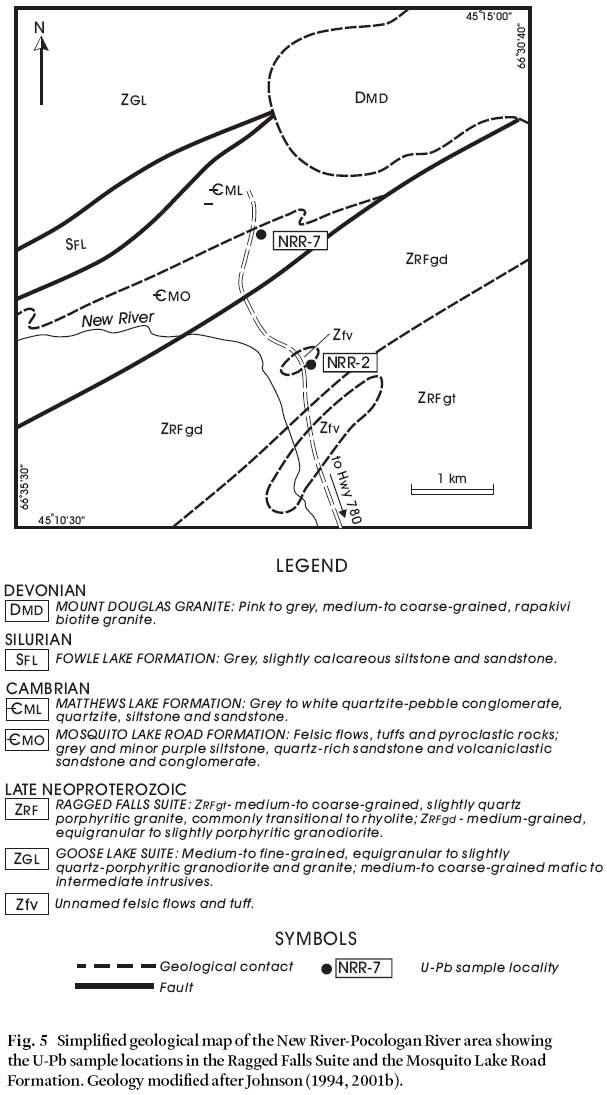
Display large image of Figure 5
18 The sampled locality is east of New River on the main haulage pulp road, informally referred to as the Mosquito Lake Road, approximately 3.7 kilometres north of Highway 780 (Fig. 5). The sample (NRR-2) was collected from the south end of a 10 metre-long outcrop along the east side of the road. The granodiorite is a relatively undeformed, medium-grained, and slightly porphyritic, and contains intensely sausseritized plagioclase in an equigranular matrix of similarly altered, finer grained plagioclase, perthite, quartz, and equant to interstitial biotite and possibly amphibole (both now chlorite). Minor carbonate veinlets and Fe-Ti oxides occur throughout the sample.
19 Data for 6 prismatic, euhedral, stubby crystals and 13 small, 3/1 (length to breadth) long, clear grains are concordant and overlap within their estimated errors with mean 206Pb/238U and 207Pb/ 206Pb ages of 553 Ma, indicating a Late Neoproterozoic age of 553 ± 2 Ma (Fig. 3c). Data for a third fraction of 17 stubby, euhedral prisms plots to the upper right of the concordant data and indicate the presence of inherited grains in this fraction.
Discussion
20 A Late Neoproterozoic (553 ± 2 Ma) age for the granodiorite confirms that it is coeval, within error, with the granitic phase of the Ragged Falls Suite and that they are probably comagmatic. The age also supports the proposal that the intrusive rocks in the New River - Pocologan River area are part of a related suite of somewhat compositionally expanded Late Neoproterozoic plutons. A similar age is also likely for the lithologically similar Pull and Be Damned Granite. In addition, the spherulitic felsic volcanic rocks that are intruded by the granodiorite are at least this old and may be correlative with the Leavitts Head Formation described above.
MOSQUITO LAKE ROAD FORMATION
Geological setting
21 The Mosquito Lake Road Formation consists of a heterogeneous, interbedded sequence containing rhyolitic crystal tuffs and flows, felsic pyroclastic breccia, laminated phyllitic siltstone and sandstone, quartz-rich feldspathic wacke, volcanic lithic wacke, conglomerate and minor mafic volcanic rocks (Johnson 1994; Johnson and McLeod 1996, Johnson 2001b). Thin bands and lenses of iron formation and coticule layers are rare but locally present in the sandstone.
22 The Mosquito Lake Road Formation comprises a narrow, northeast-trending fault-bounded unit along the northwestern margin of the Ragged Falls Suite (Fig. 5) in the New River area of the New River Belt. The Late Devonian Mount Douglas Granite intrudes the formation to the northeast and the formation is stratigraphically overlain by quartzite-pebble conglomerate of the Matthews Lake Formation to the north. The abrupt lithological change suggests that the Mosquito Lake Road/Matthews Lake Formation contact is disconform-able. However, based on the presence of similar clastic rocks in both formations, the hiatus is not considered to be regionally significant (Johnson 2001b). Both the Mosquito Lake Road and Matthews Lake formations are truncated by a major ductile fault zone (Saint George – Wheaton Brook zone of Currie 1988) that marks the boundary with Silurian clastic sedimentary rocks of the Fowle Lake Formation to the north.
Purpose of dating
23 The existence of this unique volcanic sequence in southern New Brunswick fringing the northwestern margin of the Ragged Falls Suite was unrecognised prior to mapping by Johnson (1994). Associated quartzite and quartzite pebble-rich conglomerate of the Mathews Lake Formation were recognized in the New River Belt and assigned to the Lower Silurian by McCutcheon (1981). His assignment of this age to the clastic sequence, although somewhat tentative, had important regional ramifications regarding diachronism of basal Silurian sections in southern New Brunswick. Therefore, establishing an age for these unique rocks was considered essential for the compilation project.
Sample description and results
24 Felsic volcanic sample NRR-7 was collected from a 75 metre-long outcrop along the east side of the Mosquito Lake Road, approximately 5.4 kilometres north of Highway 780 (Fig. 5). The sample site is located near the northern end of the outcrop about 5 m below the exposed stratigraphic contact with the overlying Matthews Lake Formation. The sample consists of light grey, sparsely porphyritic, aphanitic rhyolite with potassium feldspar, and lesser amounts of quartz and granophyre phenocrysts. The matrix is composed of nearly totally recrystallized and partly sericitized, minute spherulites cut by minor quartz veinlets.
25 Two fractions consisting of 40 and 50 abraded zircon grain fragments gave data with analytically identical 207Pb/206Pb ages of 514 and 516 Ma that are 0.1% and 2.2% discordant, respectively. Given the concordance of the upper point, the best estimate of the age is 514 ± 2 Ma (Fig. 3d), but must be considered a maximum as the age is based on two fractions only.
Discussion
26 The U-Pb date of 514 ± 2 Ma obtained during this study establishes a late Early Cambrian age for the Mosquito Lake Road Formation and provides a maximum age for the overlying Matthews Lake Formation. The recognition of Early Cambrian units in the New River - Pocologan River area has important implications concerning correlations regionally. We originally reported the age of the Mosquito Lake Road Formation as Late Cambrian (Johnson and McLeod 1996), however, subsequent recalibration of Cambrian geochronol-ogy has since indicated that these rocks are in fact of late Early Cambrian age (Landing et al. 1998).
27 Within the context of field evidence from detailed mapping programs that have characterized the nature of basement rocks in the New River Belt and Cambrian cover sequences, the 514 ± 2 Ma age for the Mosquito Lake Road Formation may have implications for future terrane analysis of the belt. One factor to consider is that an ash bed from the predominantly clastic, fossiliferous Hanford Brook Formation in the classic Cambrian section in the Saint John Group yielded a similar U-Pb age of 511 ± 1 (Landing et al. 1998), within error of the Mosquito Lake Road date. This effectively provides an absolute date for the predominantly clastic, fossiliferous Hanford Brook strata in the Long Reach area and provides a temporal link for contrasting Cambrian lithological packages within the New River Belt. The lithological contrasts, the fact that the Mosquito Lake Road Formation apparently evolved in an arc-type tectonic setting (Johnson and McLeod 1996), and the realization that the clastic rocks of the Hanford Brook Formation were deposited on a continental platform (e.g. Landing and Westrop 1998), led Johnson (2001b) to suggest that the New River Belt is transacted by a major tectonic boundary, termed the Robin Hood Lake Fault, and that the belt is composite.
BAYSWATER FORMATION
Geological setting
28 The Bayswater Formation comprises a sequence of rhyo-litic to dacitic, lithic to lithic-crystal lapilli tuff and subordinate andesitic lithic tuff, thin-bedded tuffaceous siltstone and micaceous phyllite, and constitutes one of several steeply-dipping, northwest-younging volcanic sequences within the Early Silurian Kingston Group (Figs. 1, 6). It is situated in the northeastern part of the Kingston Belt, immediately west of the Kennebecasis Fault, which forms the eastern margin of the belt (Barr and White 2001a, b, c). The volcanic rocks of this unit commonly exhibit welded and flow-banded textures and are intruded by granite and amphibolite and felsic porphyry dykes (Barr and White 2001a). The formation is gradationally underlain by basaltic to andesitic rocks of the Raymond Mountain Formation and overlain by rhyolitic tuff of the Waltons Lake Formation (Barr and White 2001a, c). In the southwestern part of the belt on Campobello Island, volcanic sequences virtually identical to those in the northeastern (upper) part of the Kingston Group are gradationally overlain by fossiliferous turbidites of the Lower Silurian Quoddy Formation (McLeod and Pickerill 2001; McLeod et al. 2001), which constitute the extension of the Kingston Belt farther to the southwest in Maine.
Fig. 6 Simplified geological map of the Kingston Peninsula showing the U-Pb sample locations in the Centreton Granite and the Bayswater Formation. Geology modified after Barr and White (1998, 2001a) and McLeod et al. (1994a).Purpose of dating
29 At the time this unit was sampled, the age of the strati-fied rocks in the Kingston Belt was equivocal, as depicted by McLeod et al. (1994a, b). Selected felsic "dykes" in the northeastern part of the belt west of the Saint John River, which were subsequently recognized as plutonic units (Barr and White, 1998), were dated as Silurian (Doig et al. 1990). However, Neoproterozoic to Silurian ages for most or part of the belt were postulated by numerous authors (summarized in Barr and White 2001a; McLeod et al. 2001). During the present study, it was recognized that felsic volcanic rocks identical to those in this area and intruded by similar plutonic rocks, cropped out over the entire strike length of the belt. It was anticipated that dating these volcanic rocks (and associated intrusions; see next section) east of the Saint John River, where relationships were firmly established, would provide accurate ages for much of the Kingston Belt.
Sample description and results
30 The sample locality is in a small rock quarry south of Highway 845, on the east side of the bridge that crosses Milkish Creek near the community of Bayswater (Fig. 6). The dated sample G/08-11-91 is a felsic tuff and consists of deformed, crystal-rich lithic tuff with sub-equal proportions of crystal and lithic fragments in a recrystallized quartzose matrix. Crystals consist of potassium feldspar, plagioclase and lesser amounts of quartz. Lithic clast compositions are highly variable and include felsic and mafic volcanic rocks and fine-grained clastic sedimentary rocks. A single well-developed fabric is accentuated by muscovite, chlorite, and epidote, all of which are partly overgrown by biotite.
31 The sample contains abundant, mostly uncracked, pale to slightly yellow, prismatic zircon grains. The challenge in dating this rock is the low radiogenic Pb content, a reflection of the low U concentration in the zircon. Therefore, a large sample size was used to obtain measurable amounts of Pb and to increase the sample-to-background ratio (i.e. to reduce the common Pb correction).
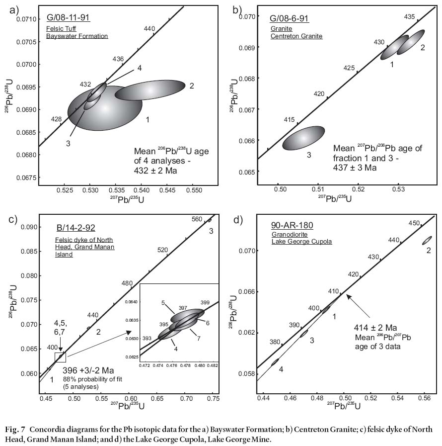
32 Of the four analyses, fractions 3 and 4 are the most concordant, yielding 206Pb/238U ages of 431 Ma and 432 Ma, respectively (Fig. 7a). The weighted 206Pb/238U average age of the four analyses is 431.8 ± 0.4 Ma. Fractions 1 and 2 have large errors due to the small sample sizes, and fraction 2 is made up of cracked, second-best grains that yield a more discordant result. A regression of fractions 3 and 4 through 10 Ma gives an upper intercept age of 436 ± 3 Ma with a 40% probability of fit. The 206Pb/238U age is least susceptible to bias from inheritance or excess common Pb, and is, therefore, the most reliable estimate of the age of crystallization. However, the error of the weighted mean is probably unrealistically low. The best minimum age is interpreted to be 432 ± 2 Ma. The upper intercept age of 436 ± 3 Ma utilizes the most concordant results, and is therefore considered the best estimate for the age of the Bayswater Formation.
Discussion
33 The date from the Bayswater Formation effectively established an Early Silurian age for the volcanic succession in the northeastern part of the Kingston Belt, and a minimum age for the mafic and felsic intrusive rocks. Subsequent mapping and dating programs have firmly established Early Silurian ages for the remainder of the volcanic sequence to the southwest (Barr and White 2001a, c; Barr et al. 2002b), and have helped clarify the relationship between predominantly felsic volcanic sequences within the belt in New Brunswick, and tur-bidite-mafic volcanic sequences in southwestern-most New Brunswick and Maine (McLeod et al. 2001). Also, recent geo-chemical data suggest that the volcanic rocks of the Kingston Group and coeval intrusions formed in a continental margin, volcanic-arc tectonic environment (Barr et al. 2002b; McLeod et al. 2001). Consequently, the U-Pb ages have helped to constrain the timing of mid Paleozoic arc-related volcanism in the region.
CENTRETON GRANITE
Geological setting
34 The Centreton Granite is one of several massive to deformed, elongate plutons that intrude the volcanic sequences of the Kingston Belt (Fig. 1 and 6) (McCutcheon and Ruitenberg 1987; Barr et al. 1999; Barr and White 2001a, b, c). This particular intrusion, which is about 7 kilometres long and 2 kilometres wide, intrudes the predominantly felsic to intermediate volcanic rocks of the Bayswater, Waltons Lake, and Westfield formations northeast of the Saint John River (Barr and White 2001a, c).
Purpose of dating
35 As discussed in the previous section, the age of the stratified and intrusive rocks in the Kingston Belt was equivocal at the time the dating program was conducted, and this sample was collected to augment the results of radiometric data from the Bayswater Formation.
Sample description and results
36 Sample G/08-6-91 was collected from a 10 m-long outcrop along the west side of the road to Centreton, 2.6 kilometres north of the corner at Whites Mills (Fig. 6). However, subsequent to the time that the sample was collected, the road was modified and the site is no longer exposed. At this locality the rocks exhibit a well-developed regional fabric and were chosen to ensure that the oldest possible date for these intrusions would be obtained. The sample is light grey, fine-grained granite with abundant plagioclase phenocrysts, a few plagioclase glomerocrysts, subordinate potassium feldspar, and minor quartz phenocrysts. The matrix consists of granulated pheno-cryst material and a mesostasis of partly recrystallized quartz and feldspar. The most abundant secondary minerals are bio-tite locally parallel to the fabric and epidote that occurs both as an alteration product of plagioclase and in the matrix.
37 Data for one fraction consisting of seven stubby, euhedral crystals and another consisting of two flat grains, which were selected to avoid cores, give analytically identical ages of 437 and 436 Ma that are 1.6 and 5.5% discordant, respectively, to zero (Fig. 7b). A third fraction of five 3/1 euhedral prisms contains a small amount of inheritance as it has an older 207Pb/ more widespread in the Kingston Belt than previously thought.206Pb age of 449 Ma. Given the identical 207Pb/206Pb ages of the The date on the Centreton Granite affirms an Early Silurianother two fractions, inheritance can be ruled out and an age of age for the plutonic rocks in the northeastern part of the belt437 ± 3 Ma is established.
Fig. 7 Concordia diagrams for the Pb isotopic data for the a) Bayswater Formation; b) Centreton Granite; c) felsic dyke of North Head, Grand Manan Island; and d) the Lake George Cupola, Lake George Mine.Discussion
38 As a result of the detailed mapping conducted by Barr and White (2001a, c), granitoid intrusions were found to be much more widespread in the Kingston Belt than previously thought. The date on the Centreton Granite affirms an Early Silurian age for the plutonic rocks in the northeastern part of the belt and supports the idea that the intrusive and extrusive units are comagmatic, as previously suggested by their lithological and chemical similarities (Barr et al. 1999, 2002b). The U-Pb date also helps corroborate an Early Silurian age for subductionrelated magmatism in southern New Brunswick as mentioned in the preceding section.
FELSIC DYKES OF NORTH HEAD, GRAND MANAN ISLAND
Geological setting
39 Reconnaissance mapping of pre-Mesozoic rocks on Grand Manan Island (Fig. 1, 8) was undertaken for the compilation project as these rocks were very poorly understood and oversimplified at the time. During the mapping, a sequence of mafic flows and breccias at North Head, assigned various ages ranging from Late Neoproterozoic to Silurian (e.g. Alcock 1948; McLeod et al. 1994a, 1998), were found to be intruded by irregular granite dykes up to several metres wide. These mafic flows and breccias were recently assigned to the North Head Formation of possible Silurian age (Fyffe and Grant 2000, 2001).
Purpose of dating
40 To clarify the age of volcanic and sedimentary rocks underlying the eastern part of Grand Manan Island, a U-Pb dating program was initiated in this study. The granitic dykes intruding the mafic volcanic sequence near North Head were one of the few localities with potentially datable material recognized at the time. The dykes were chosen to provide a minimum age for the mafic volcanic sequence.
Sample description and results
41 Sample B/14-2-92 was collected along the shore about 0.5 kilometres north of Sawmill Cove, east of the village of North Head (Fig. 8). The granite dyke that was sampled is undeformed and contains two populations of phenocrysts. Individual and glomerocrystic plagioclase comprise the larger (1 cm) population, while the smaller (0.5 cm) crystals include quartz, plagio-clase, potassium feldspar, and completely chloritized relict biotite and amphibole. The matrix is composed of an aphanitic quartz-feldspar mosaic. Except for minor carbonate and quartz veining, both the matrix and the phenocrysts are unaffected by alteration.
Fig. 8 Simplified geological map of northeastern Grand Manan Island showing the U-Pb sample location of unnamed felsic dykes. Geology modified after Fyffe and Grant (2000).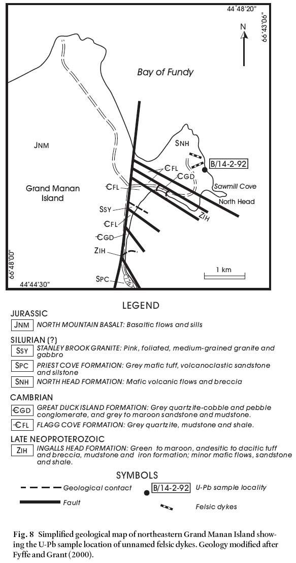
Display large image of Figure 8
42 The sample contained abundant, pale yellow zircon grains, the majority of which are 2/1 and 1/1 prisms. A small percentage is 3/1 needles, and some zircons with fuzzy, opaque centres suggest the possibility of inherited cores. A total of seven analyses were conducted and the data are quite scattered on the concordia diagram (Fig. 7c). Analyses 2 and 3 are from multi-grain fractions (6 and 14 grains, respectively) and the data indicate a mixture of old and young zircon, whereas analyses 4, 5, 6 and 7, comprising both single- and multi-grain fractions (1, 3, 1 and 3 grains, respectively), form a cluster between 394 and 398 Ma for the 207Pb/206Pb age. Fraction 1 is composed of cracked grains and is more discordant.
43 A regression of data for fractions 1, 4, 5, 6 and 7 gives an upper intercept age of 396 +3/-2 Ma with 88% probability of fit. Data for analyses 4, 5, 6, and 7 overlap within error and show no indication of Pb loss or inheritance. A regression line calculation through these data to 10 Ma gives the same upper intercept age with a slightly higher error.
Discussion
44 The relatively young age of the granite was disappointing as it failed to better constrain the age of the mafic rocks of the North Head Formation; however, the ca. 396 Ma date demonstrates the presence of previously unrecognized Lower to Middle Devonian granites on Grand Manan Island and provides a minimum age for the North Head Formation. These granite dykes are similar in age to some of the plutonic rocks in the Saint George Batholith on the mainland (McLeod 1990).
LAKE GEORGE CUPOLA, LAKE GEORGE MINE
Geological setting
45 A buried granitic cupola, exposed underground at the Lake George Antimony Mine about 30 km west of Fredericton (Fig. 1), was correlated with the Hawkshaw Granite (Lutes 1979, 1987) by Seal et al. (1985). The Hawkshaw Granite comprises most of the eastern lobe of the Pokiok Batholith, which crops out about three kilometres west of the Lake George Antimony Mine (Fig. 1). The intrusion is chiefly comprised of medium- to coarse-grained, megacrystic biotite granite containing alkali feldspar phenocrysts up to 4 cm long (Lutes 1979) but also contains medium-grained, seriate granodiorite.
Purpose of study
46 The purpose of dating the granitic cupola was to establish constraints on the timing of ore deposition at the Lake George Mine, because vein systems containing Sb, W-Mo, and Au-polymetallic mineralization were considered to be directly related to intrusion of this granite (Seal et al. 1985). This interpretation has been supported by recent investigations by Caron (1996) and Yang et al. (2002). It was anticipated that, if the correlation with the Hawkshaw phase of the Pokiok Batholith could be verified, a strong case could be made to promote mineral exploration activities around the Pokiok Batholith as well.
Sample description and results
47 The sampled site is located at the 13th level, at station SP 1307, underground at the Lake George Antimony Mine. The sample (90-AR-180) is an undeformed, medium-grained, seriate granodiorite that is mostly composed of partly to totally saussuritized plagioclase, quartz, and lesser amounts of altered potassium feldspar and variably chloritized biotite. Accessory minerals include secondary muscovite, Fe-Ti oxides, and very minor titanite, relict amphibole(?), and veinlets of carbonate.
48 Data for three fractions of high-quality, big and small, needle-like crystals are near collinear and project to 412 +5/- 4 Ma and -25 Ma (Fig. 7d). The mean 207Pb/206Pb age for the three points is 414 ± 2 Ma, which is a better estimate for the age of emplacement, given that a negative lower intercept is impossible. We note that, as expected, the largest abraded needles and fragments gave the most concordant results, followed by data for abraded small needles and unabraded needles. A small amount of inherited material is evident in the fourth fraction, which yielded a 207Pb/206Pb age of 508 Ma.
Discussion
49 The U-Pb date obtained during this project corroborates the correlation of the granite cupola in underground workings at Lake George Antimony Mine with the main body of the Hawkshaw Granite at surface, which previously yielded a U-Pb date of 411 ± 2 Ma (Bevier and Whalen 1990). Importantly, it highlights the regional potential for intrusion-related gold deposits near the contact of the Pokiok Batholith.
ACKNOWLEDGEMENTS
The authors are indebted to geoscientists and laboratory staff who have contributed to the interpretation of these dates through discussions and several field trips in southern New Brunswick, in particular, Sandra Barr, Chris White and Les Fyffe. Figures were drafted by Maurice Mazerolle. The project was funded by the Canada-New Brunswick Cooperation Agreement on Mineral Development 1990– 1995 and the New Brunswick Department of Natural Resources and Energy. The manuscript benefited from reviews by Chris White and Les Fyffe who are thanked for their constructive criticism.REFERENCES
Alcock, F.J. 1948. Campobello, New Brunswick. Geological Survey of Canada, Map 964A.
Barr, S.M., & White, C.E. 1996. Contrasts in Late Precam-brian – Early Paleozoic tectonothermal history between Avalon Composite Terrane sensu-stricto and other possible peri-Gondwanan terranes in southern New Brunswick and Cape Breton Island, Canada. In Avalonian and Related Peri-Gondwanan Terranes of the Circum-North Atlantic. Edited by R.D. Nance and M.D. Thompson. Geological Society of America, Special Paper 304, pp. 95– 108.
Barr, S.M., & White, C.E. 1998. Geology of the Kingston Peninsula (parts of NTS 21 G/08, G/09, H/05, H/12), Kings and Queens Counties, New Brunswick. New Brunswick Department of Natural Resources and Energy, Minerals and Energy Division, Plate 98-16.
Barr, S.M., & White, C.E. 1999. Field relations, petrology and structure of Neoproterozoic rocks in the Caledonian Highlands, Southern New Brunswick. Geological Survey of Canada Bulletin, 530, 101 p.
Barr, S.M., & White, C.E. 2001a. The Kingston Group: a redefined Silurian stratigraphic unit in southern New Brunswick. In Current Research 2000. Complied by B.M.W. Carroll. New Brunswick Department of Natural Resources and Energy, Minerals and Energy Division, Mineral Resources Report 2001-4, pp. 1– 14.
Barr, S.M., & White, C.E. 2001b. Terranes in the Pocologan area, southern New Brunswick. In Guidebook to field trips in New Brunswick and Western Maine. Edited by R.K. Pickerill and D.R. Lentz, New England Intercollegiate Geological Conference, 93rd Annual Meeting, September 21– 23, 2001 Fredericton, New Brunswick Trip B-2, pp. B2-1 – B2-14.
Barr, S.M., & White, C.E. 2001c. Geology of the Kingston and Brookville terranes, New Brunswick (parts of NTS 21G/ 01, G/02, G/08, G/09, 21H/05 and H/12). New Brunswick Department of Natural Resources and Energy, Minerals and Energy Division, Plates 2001-30 to 2001-45.
Barr, S.M., Bevier, M.L., White, C.E., & Doig, R. 1994. Magmatic history of the Avalon terrane of southern New Brunswick, Canada, based on U-Pb (zircon) geochronology. Journal of Geology, 102, pp. 399– 409.
Barr, S.M., White, C.E., & McLeod, M.J. 1999. Geology of the Silurian Kingston terrane, southern New Brunswick. In Current Research 1998. Edited by B.M.W. Carroll. New Brunswick Department of Natural Resources and Energy, Minerals and Energy Division, Mineral Resources Report, 99-4, pp. 1– 17.
Barr, S., Fyffe, L., King, S., McLaughlin, K., McLeod, M., Miller, B., Thompson, M., & White, C. 2002a. New U-Pb zircon ages, geophysical compilations, and terranes in southern New Brunswick. Abstracts 2002: 27th Annual Review of Activities. New Brunswick Department of Natural Resources & Energy, Information Circular 2002-1, pp. 3– 5.
Barr, S.M., White, C.E., & Miller, B.V. 2002b. The Kingston terrane, southern New Brunswick, Canada: Evidence for a Silurian volcanic arc. Geological Society of America Bulletin, 114, pp. 964– 982.
Barr, S.M., White, C.E., & Miller, B.V. 2003. Age and Geochemistry of Late Neoproterozoic and Early Cambrian Igneous Rocks in Southern New Brunswick: Similarities and Contrasts. Atlantic Geology, 39, pp. 55– 73.
Berry, H.N., & Osberg, P.H. 1989. A stratigraphic synthesis of eastern Maine and western New Brunswick. In Studies in Maine Geology. Edited by R.D. Tucker and R.G. Marvinney. Maine Geological Survey, Department of Conservation, Volume 2: Structure and Stratigraphy, pp. 1– 32.
Bevier, M.L., & Whalen, J.B. 1990. U-Pb geochronology of Silurian granites, Miramichi Terrane, New Brunswick. In Radiogenic Age and Isotopic Studies: Report 3. Geological Survey of Canada, Paper 89-2, pp. 93– 100.
Caron, A. 1996. Geology of the Pokiok Batholith aureole, with emphasis on the Lake George Mine, York County, New Brunswick. New Brunswick Department of Natural Resources and Energy, Minerals and Energy Division, Geo-science Report 94-2, 91 p.
Currie, K.L. 1988. Saint George map area: the end of the Avalon zone in southern New Brunswick. In Current Research, Part B. Geological Survey of Canada, Paper 88-1B, pp. 9– 16.
Currie, K.L. 1989 Revised late Precambrian stratigraphy near Saint John, New Brunswick. In Current Research, Part B - Eastern and Atlantic Canada. Geological Survey of Canada, Paper 89-1B, pp. 39– 45.
Currie, K.L. 1992. The "Lorneville Beds": a latest Precam-brian sequence near Saint John, New Brunswick. In Current Research, Part D. Geological Survey of Canada, Paper 92-1D, pp. 35– 43.
Currie, K.L., & Hunt, P.A. 1991. Latest Precambrian igneous activity near Saint John, New Brunswick. In Radiogenic Age and Isotopic Studies: Report 4. Geological Survey of Canada, Paper 90-2, pp. 11– 17.
Currie, K.L., & McNicoll, V.J. 1999. New data on the age and geographic distribution of Neoproterozoic plutons near Saint John, New Brunswick. Atlantic Geology, 35, pp. 157– 166.
Davis, D.W. 1982. Optimum linear regression and error estimation applied to U-Pb data. Canadian Journal of Earth Sciences, 19, pp. 2141– 2149.
Doig, R., Nance, R.D., Murphy, J.B., & Casseday, R.P. 1990. Evidence for Silurian sinistral accretion of Avalon composite terrane in Canada. Geological Society of London Journal, 147, pp. 927– 930.
Fyffe, L.R. 1998. Bedrock geology of the Jake Lee Mountain area (NTS 21G/02g), Charlotte County, New Brunswick. New Brunswick Department of Natural Resources and Energy, Minerals and Energy Division, Plate 98-70.
Fyffe, L.R., & Fricker, A. 1987. Tectonostratigraphic terrane analysis of New Brunswick. Maritime Sediments and Atlantic Geology, 23, pp. 113– 123.
Fyffe, L.R., & Grant, R.H. 2000. Geology of Grand Manan Island (parts of NTS 21 B/10 and B/15). New Brunswick Department of Natural Resources and Energy, Minerals and Energy Division, Plate 2000-29 (revised 2003).
Fyffe, L.R., & Grant, R.H. 2001. The Precambrian and Paleozoic geology of Grand Manan Island. In Guidebook to Field Trips in New Brunswick and western Maine. Edited by R.K. Pickerill and D. Lentz. New England Intercollegiate Geological Conference, 93rd Annual Meeting, September 21– 23, 2001 Fredericton, New Brunswick, Trip A5, pp. A5-1 – A5-13.
Greenough, J.D., McCutcheon, S.R., & Papezik, V.S. 1985. Petrology and geochemistry of Cambrian volcanic rocks from the Avalon Zone in New Brunswick. Canadian Journal of Earth Sciences, 22, pp. 881– 892.
Helmstaedt, H. 1968. Structural analysis of the Beaver Harbour area, Charlotte County, New Brunswick. Unpublished Ph.D. thesis, University of New Brunswick, Fredericton, New Brunswick, 196 p.
Jaffey, A.J., Flynn, K.F., Glendenin, L.E., Bentley, W.C., & Essling, A.M. 1971. Precision measurements of half-lives and specific activities of 235U and 238U. Physical Reviews, C4, pp. 1889– 1906.
Johnson, S.C. 1994. Bedrock geology of the Pocologan River area: New Brunswick Department of Natural Resources and Energy, Minerals and Energy Division, Plate 94-43.
Johnson, S.C. 2000. Bedrock geology of the Loch Alva – Long Reach area. New Brunswick. Department of Natural Resources and Energy, Minerals and Energy Division, Plate 2000-18.
Johnson, S.C. 2001a. Stratigraphy of Neoproterozoic and Devonian – Carboniferous volcanic and epiclastic rocks in the Long Reach and Taylors Island areas, New Brunswick. In Guidebook to Field Trips in New Brunswick and western Maine. Edited by R.K. Pickerill and D. Lentz. New England Intercollegiate Geological Conference, 93rd Annual Meeting, September 21– 23, 2001 Fredericton, New Brunswick, Trip A2, pp. A2-1 – A2-15.
Johnson, S.C. 2001b. Contrasting geology in the Pocologan River and Long Reach areas: implications for the New River Belt and correlations in southern New Brunswick and Maine. Atlantic Geology, 3 7, pp. 61– 79.
Johnson, S.C., & McLeod, M.J. 1996. The New River Belt: an unique segment along the western margin of the Avalon composite terrane, southern New Brunswick. In Avalonian and Related Peri-Gondwanan Terranes of the Circum-North Atlantic. Edited by R.D. Nance and M.D. Thompson. Geological Society of America, Special Paper 304, pp. 149– 164.
Johnson, S.C., & McLeod, M.J. 2000. Bedrock geology of the Belleisle Bay-Long Reach area, southern New Brunswick. New Brunswick Department of Natural Resources and Energy, Minerals and Energy Division, Plate 2000-36.
Krogh, T.E. 1973. A low contamination method for hydro-thermal decomposition of zircon and extraction of U and Pb for isotopic age determinations. Geochimica et Cosmo-chimica Acta, 46, pp. 637– 649.
Krogh, T.E. 1982. Improved accuracy of U-Pb zircon age by the creation of more concordant systems using an air abrasion technique. Geochimica et Cosmochimica Acta, 3 7, pp. 485– 494.
Landing, E., & Westrop, S.R. 1998. Avalon 1997. The Cambrian Standard. New York State Museum Bulletin, 492, 92 p.
Landing, E., Bowring, S.A., Davidek, K.L., Westrop, S.R., Geyer, G., & Heldmaier, W. 1998. Duration of the Early Cambrian: U-Pb ages of volcanic ashes from Avalon and Gondwana. Canadian Journal of Earth Sciences, 35, pp. 329– 338.
Lutes, G.G. 1979. Geology of Fosterville-North and Eel lakes, map area G-23 and Canterbury-Skiff Lake map area H-23. New Brunswick Department of Natural Resources, Mineral Resources Branch, Map Report 79-3, 22 p.
Lutes, G.G. 1987. Geology and geochemistry of the Pokiok Batholith, New Brunswick. New Brunswick Department of Natural Resources and Energy, Minerals and Energy Division, Report of Investigation 22, 55 p.
McCutcheon, S.R. 1981. Revised stratigraphy of the Long Reach area, southern New Brunswick: Evidence for major, northwestward-directed Acadian thrusting. Canadian Journal of Earth Sciences, 18, pp. 646– 656
McCutcheon, S.R., & Ruitenberg, A.A. 1987. Geology and mineral deposits, Annidale-Nerepis area, New Brunswick. New Brunswick Department of Natural Resources and Energy, Mineral Resources Division, Memoir 2, 141 p.
McLeod, M.J. 1990. Geology, geochemistry, and related mineral deposits of the Saint George Batholith; Charlotte, Queens, and Kings counties, New Brunswick. New Brunswick Department of Natural Resources and Energy, Mineral Resource Report 5, 169 p.
McLeod, M.J. 1995a. Bedrock geology and metallic mineral occurrences in the Letang – Head Harbour Passage area, Charlotte county, New Brunswick. In Current Research 1994. Compiled and edited by S.A.A. Merlini. New Brunswick Department of Natural Resources and Energy, Minerals and Energy Division, Miscellaneous Report 18, pp. 141– 156.
McLeod, M.J. 1995b. Geology of the Letang area (part of NTS 21 G/02c), Charlotte County, New Brunswick. New Brunswick Department of Natural Resources and Energy, Minerals and Energy Division, Plate 95-7A.
McLeod, M.J., & Pickerill, R.K. 2001. Bedrock geology of Campobello Island: Remnants of a Silurian arc and back-arc complex in southwestern New Brunswick. In Guidebook to Field Trips in New Brunswick and western Maine. Edited by R.K. Pickerill and D. Lentz. New England Intercollegiate Geological Conference, 93rd Annual Meeting, September 21– 23, 2001 Fredericton, New Brunswick, Trip B4, pp. B4-1 – B4-20.
McLeod, M.J., Ruitenberg, A.A., & Krogh, T.E. 1992. Geology and U-Pb geochronology of the Annidale Group, southern New Brunswick: Lower Ordovician volcanic and sedimentary rocks formed near the southeastern margin of Iapetus Ocean. Atlantic Geology, 28, pp. 181– 192.
McLeod, M.J., Johnson, S.C., & Ruitenberg, A.A. 1994a. Geological map of southwestern New Brunswick. New Brunswick Department of Natural Resources and Energy, Mineral Resources, Map NR-5.
McLeod, M.J., Johnson, S.C., & Ruitenberg, A.A. 1994b. Geological map of southeastern New Brunswick. New Brunswick Department of Natural Resources and Energy, Mineral Resources, Map NR-6.
McLeod, M.J., Johnson, S.C., & Stringer, P. 1998. Bedrock geological compilation of the Campobello area (NTS 21 B/14, 21 B/15), Charlotte County, New Brunswick. New Brunswick Department of Natural Resources and Energy, Minerals and Energy Division, Plate 98-52.
McLeod, M.J., Pickerill, R.K., & Lux, D. 2001. Mafic intrusions on Campobello Island and recent mapping in the Passamaquoddy Bay area: Implications for Maine-New Brunswick correlations. Atlantic Geology, 3 7, pp. 7– 40.
Ruitenberg, A.A., McLeod, M.J., & Krogh, T.E. 1993. Comparative metallogeny of Ordovician volcanic and sedimentary rocks in the Annidale-Shannon (New Brunswick) and Harborside-Blue Hill (Maine) areas: implications of new U-Pb age dates. Exploration and Mining Geology, 2, No. 4, pp. 355– 365.
Seal, R.R., Clark, A.H., & Morrissy, C.J. 1985. Lake George southwestern New Brunswick: a Silurian, multi-stage, polymetallic (Sb-W-Mo-Au-base metal) hydrothermal centre. In Recent Advances in the Geology of Granite-Related Mineral Deposits. Edited by R.P. Taylor and D.F. Strong. Canadian Institute of Mining and Metallurgy Conference on Granite-Related Mineral Deposits, September 15– 17, 1985, Halifax, Nova Scotia, Special Volume 39, pp. 252– 264.
Yang, X., Lentz, D.R., Hall, D.C., & Chi, G. 2002. Petrology of the Lake George granodiorite stock, New Brunswick: implications for crystallization conditions, volatile exsolu-tion and W-Mo-Au-Sb mineralization. Geological Survey of Canada, Current Research, 2002-E14, 12p.
Editorial responsibility: Sandra M. Barr
