Comparison of clast and matrix dispersal in till:
Charlo-Atholville area, north-central New Brunswick
M. L. DicksonIndiana Geological Survey, 611 North Walnut Grove, Bloomington, IN 47405-2208, U.S.A.
B. E. Broster
Quaternary and Environmental Studies Group (QUEST), Department of Geology, University of New Brunswick, P. O. Box 4400, Fredericton, NB E3B 5A3, Canada * Corresponding author
M. A. Parkhill
New Brunswick Department of Natural Resources, Geological Surveys Branch, P. O. Box 50, Bathurst, NB E2A 3Z1, Canada
Date received March 4, 2004 ¶ Date Accepted October 6, 2004
ABSTRACT
Striations and dispersal patterns for till clasts and matrix geochemistry are used to define flow directions of glacial transport across an area of about 800km2 in the Charlo-Atholville area of north-central New Brunswick. A total of 170 clast samples and 328 till matrix samples collected for geochemical analysis across the region, were analyzed for a total of 39 elements. Major lithologic contacts used here to delineate till clast provenance were based on recent bedrock mapping. Eleven known mineral occurrences and a gossan are used to define point source targets for matrix geochemical dispersal trains and to estimate probable distance and direction of transport from unknown sources. Clast trains are traceable for distances of approximately 10 km, whereas till geochemical dispersal patterns are commonly lost within 5 km of transport. Most dispersal patterns reflect more than a single direction of glacial transport.These data indicate that a single till sheet, 1–4 m thick, was deposited as the dominant ice-flow direction fluctuated between southeastward, eastward, and northward over the study area. Directions of early flow represent changes in ice sheet dominance, first from the northwest and then from the west. Locally, eastward and northward flow represent the maximum erosive phases. The last directions of flow are likely due to late glacial ice sheet drawdown towards the valley outlet at Baie des Chaleurs.RÉSUMÉ
L'équipe utilise les striures et les tracés de dispersion des clastes de till ainsi que les caractéristiques géochimiques de la gangue pour définir les orientations d'écoulement du transport glaciaire dans un secteur d'environ 800 kilomètres carrés de la région de Charlo-Atholville, dans le centre-nord du Nouveau-Brunswick. On a prélevé dans la région au total 170 échantillons de clastes et 328 échantillons de gangue du till en vue d'analyses géochimiques, et on a analysé leur teneur en 39 éléments particuliers. Les principales zones de contact lithologique utilisées dans le cadre de cet exercice pour délimiter la provenance des clastes de till ont été basées sur de récents travaux de cartographie du substrat rocheux. Onze venues minérales reconnues et un chapeau ferrugineux servent à définir les objectifs des sources ponctuelles des tracés de dispersion géochimique de la gangue de même qu'à estimer l'orientation et la distance probables du transport à partir des sources inconnues. Il est possible de retracer les traînées de clastes sur des distances d'une dizaine de kilomètres, tandis que les tracés de dispersion géochimique du till s'effacent généralement avant moins de cinq kilomètres. La majorité des tracés de dispersion évoquent plus d'une direction de transport glaciaire. Ces données révèlent qu'une nappe de till particulière d'une épaisseur d'un à quatre mètres s'est déposée pendant que l'orientation prédominante des écoulements de glaces a varié entre le sud-est, l'est et le nord à l'intérieur du secteur d'étude. Les orientations de l'écoulement primitif représentent les changements survenus dans la nappe glaciaire prédominante, l'écoulement provenant d'abord du nord-ouest, puis de l'ouest. L'écoulement vers l'est et vers le nord représente par endroits des phases d'érosion maximale. Les dernières orientations de l'écoulement sont probablement liées à un appauvrissement de la nappe tardiglaciaire en direction de la décharge de la vallée dans la baie des Chaleurs. [Traduit par la rédaction.]INTRODUCTION
1 Tills are first derivative sediments of bedrock (Shilts 1976) and therefore retain some of the lithological and geochemical characteristics of their original bedrock source. The abundances of source components in till are commonly used to define distinctive two-dimensional spatial patterns of concentration, so-called dispersal fans, plumes or trains (e.g., DiLabio 1990), that decrease immediately down-glacier of the bedrock source. Commonly these dispersal patterns are wedge-, amoeboid- or ribbon-shaped with concentrations elongated parallel to ice flow and decreasing in content inversely with distance from the source (Shilts 1976). The interpretation of two-dimensional dispersal patterns can be confused by: multiple ice-flow directions producing palimpsest or composite trains (Parent et al. 1996; Stea and Finck 2001); topographic influence resulting in preferential erosion or ice streaming (Broster and Huntley 1995); or post-depositional weathering and modification of geochemical content (Shilts 1976; Paulen 2001). This is particularly problematic in sub-alpine terrains such as in northern New Brunswick and other areas of Canada. Such areas are characterized by highly variable topography and ice movements, having experienced glaciation by growth of individual cirque glaciers and their coalescence into larger valley glaciers or ice sheets (e.g., Broster and Huntley 1995). In addition, the bedrock of local Appalachian terrains has been weathered to depths of up to 26 m (Veillette and Nixon 1982). This pre-glacial weathered material was incorporated into the overlying tills that locally exceed 4 m in thickness behind obstructions and along valleys and underlie a veneer of humus commonly 10 cm thick.
2 Northern New Brunswick is a region of known sulphide mineralization associated with Devonian base-metal (Cu-Pb-Zn-Ag-Mo) porphyry and skarn deposits. Eleven mineral occurrences and a gossan (Rose and Johnson 1990) were identified as potential target sources that are used to examine the effects of multiple ice-flow directions and relative variability between local and regional dispersal of till clasts and matrix geochemistry.
LOCATION, PHYSIOGRAPHY AND BEDROCK
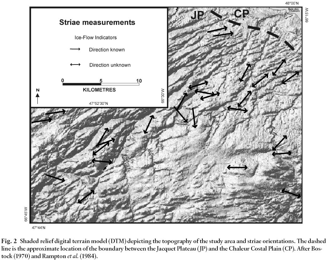
3 The study area is located in north-central New Brunswick, 20 km southeast of the city of Campbellton (Fig. 1). Access to the study area is provided by provincial highways and an extensive network of secondary and logging roads. New Brunswick is located in the Appalachian region of Canada (Bostock 1970). The province is divided into six main physiographic regions, based on tectonostratigraphic zones and structural elements, with each region subdivided into smaller physiographic elements (Bostock 1970; Rampton et al. 1984). The study area is situated in the Chaleurs Uplands physiographic region, encompassing two subdivisions: the Jacquet Plateau and the Chaleur Coastal Plain (Fig. 2). The Jacquet Plateau is a low, undulating surface with elevations generally less than 300 m, although a few ridges reach elevations of 600 m. Generally, the plateau slopes gently to the north and east and is dissected by ridges and valleys also oriented to the northeast. The Chaleur Coastal Plain, bordering the Baie des Chaleurs, is a moderately drained gently undulating plain, commonly below 70 m elevation, sloping towards the bay (Fig. 2).
Fig. 1 Location of the study area in New Brunswick and eastern Canada (insert). General striae directions, the North Maine - Notre Dame ice divide (NM / ND) and topographic areas over 500 m in elevation (hatched) are from Pronk et al. (1989).Fig. 2 Shaded relief digital terrain model (DTM) depicting the topography of the study area and striae orientations. The dashed line is the approximate location of the boundary between the Jacquet Plateau (JP) and the Chaleur Costal Plain (CP). After Bostock (1970) and Rampton et al. (1984).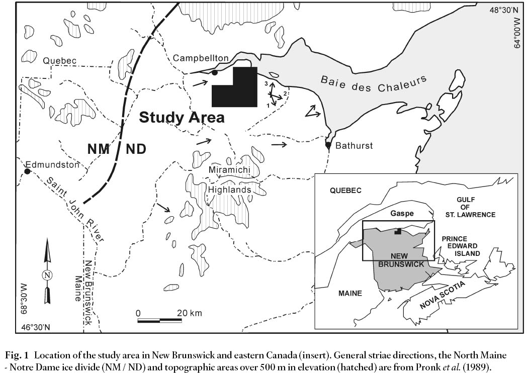
BEDROCK GEOLOGY
4 The study area is located in the Chaleur Bay Synclinorium tectonostratigraphic zone (Ruitenberg et al. 1977; Fyffe and Fricker 1987; Wilson 2000a; Carroll 2003). Bedrock is gently folded, with limbs dipping 2°– 15°. Fold hinges trend north-east-southwest and plunge gently to the southwest. The oldest rocks in the area are middle to late Ordovician arc-related mafic volcanic rocks and Caradocian slates and cherts of the Balmoral Group (Fig. 3), an inlier of Dunnage Zone rocks exposed in the core of the Popelogan Anticline (Ruitenberg et al. 1977; Williams 1979; van Staal and Fyffe 1995; Wilson 2000b, c). The Balmoral Group is disconformably overlain by late Ordovician to early Silurian Matapedia Group sedimentary rocks, consisting of turbidite deposits. The Matapedia Group is conformably overlain by Silurian sedimentary and volcanic rocks of the Chaleurs Group (Ruitenberget al.1977; Williams 1979; van Staal and Fyffe 1995; Wilson 2000b, c).
5 Bedrock is best exposed along river valleys and ridges, but is otherwise covered by a blanket of till. Argillaceous and calcareous sandstones and siltstones of the Chaleurs Group and limestones interlaminated with calcareous shales of the Matapedia Group underlie most of the western part of the study area (Fig. 3). Mafic volcanic rocks, minor tuff, chert, and graptolitic slate of the Balmoral Group are also present (Wilson 2000b, c).
6 The majority of the eastern part of the study area is under-lain by Chaleurs Group volcanic rocks. Massive amygdaloidal and porphyritic basalts occur in the northeastern and central regions of the study area. Felsic volcanic rocks and associated sedimentary rocks are found in the northeast, as well as to the south. In the north, sandstone, shale, and conglomerate of the Carboniferous Bonaventure Formation are exposed along the Baie des Chaleurs. The central region is underlain mainly by fossiliferous limestone and volcanic boulder conglomerate, breccia, and tuff.
7 According to Irrinki (1990), Devonian granite, granodiorite, and monzonite stocks are common throughout the study area (Fig. 3). Dykes and sills associated with the stocks comprise dioritic feldspar porphyry, granite porphyry, gabbro, and aplite (Quatermain 1981; Woods 1993).
Fig. 3 Bedrock geology of the study area with known mineral occurrences (modified from Irrinki (1990), Wilson (2000a, b, c), Langton (2001a, b)). URN = Unique Reference Number (Rose and Johnson, 1990)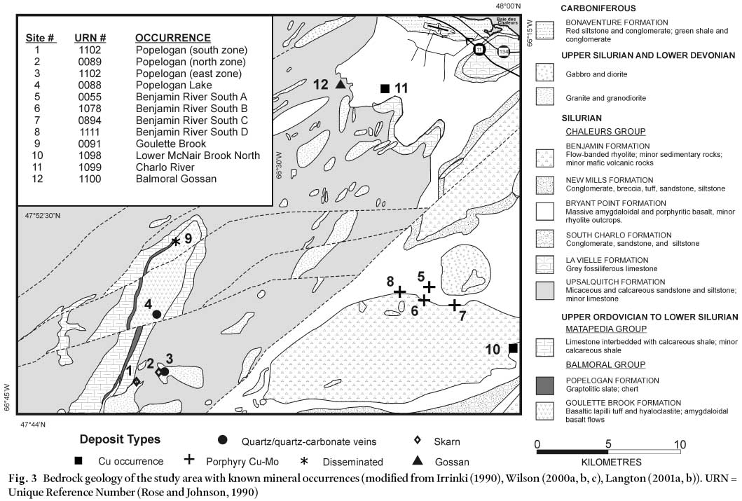
MINERAL OCCURRENCES
8 Currently, there are eleven known mineral occurrences in the study area (sites 1– 11, Fig. 3) and a gossan (site 12) that serve as point sources for glacial dispersal studies.
9 The Popelogan skarn occurrence is the largest mineral occurrence in the study area, containing 3.1 million tonnes @ 0.3% Cu (Quartermain 1981). The Popelogan Group sulphide mineralization (Cu-Mo-Pb-Zn) is found in the (1) Popelogan North, (2) Popelogan South, (3) Popelogan East, and (4) Popelogan Lake zones (Fig. 3). The Popelogan Lake mineralization occurs as disseminations and stringers hosted by quartz-carbonate veins and stockworks associated with fracture/shear zones (Rose and Johnson 1990). The Popelogan North and South zones are hosted by a skarn formed around apophyses of the Popelogan granodiorite stock and related dykes and sills intruding Silurian limestone. Sulphide mineralization (Cu, Mo, Zn, Pb, W, and As) occurs as disseminations, isolated pockets of massive material, and in quartz-chlorite-carbonate veinlets. The Popelogan East Zone (site 3, Fig. 3) is hosted by a quartz vein system cutting the Popelogan intrusion and hornfels in the contact aureole. It is characterized as a greisen and stockwork vein deposit with mineralization occurring as selvages along quartz veins and as vein fillings.
10 The Benjamin River Complex comprises four deposits of porphyry-type Cu-Mo mineralization: (5) Benjamin River South A, (6) Benjamin River South B, (7) Benjamin River South C, and (8) Benjamin River South D (Fig. 3). The mineralization is stockwork-type with fine disseminations (chalcopyrite and molybdenite), mineralized narrow fractures, and quartz veinlets, and is related to a Devonian granodiorite intrusive complex intruding Silurian Bryant Point Formation volcanic rocks (Rose and Johnson 1990).
11 The Goulette Brook Cu-Pb-Zn-Ag deposit (site 9, Fig. 3) occurs as irregular veinlets, disseminations, and small isolated pods in highly altered palagonite tuff of the Goulette Brook Formation (Rose and Johnson 1990). The Lower McNair Brook North (10) and Charlo River (11) deposits (Fig. 3) are copper occurrences; however, insufficient information is presently available to classify them further. Information is also lacking at present, on the Balmoral Gossan (site 12, Fig. 3) that may be the source of some geochemical dispersal trains (e.g., Mo), discussed below.
GLACIAL GEOLOGY
12 Local studies of the surficial geology and till geochemistry conducted by Pronk (1986, 1987), Pronk and Parkhill (1988), Lamothe (1992) and Parkhill and Doiron (2004) indicate a main ice-movement to the east followed by movement to the northeast. Pronk et al. (1989) further determined that the Baie des Chaleurs region experienced four major phases of ice flow during the Late Wisconsinan: 1) southeast, 2) east, 3) north-northeast, and 4) multidirectional. The eastward flow was found to be the most dominant trend in striaton and clast provenance studies, whereas pebble fabrics measured in glacial sediments represent the later northeastward flow (Pronket al. 1989). They attributed this to two possibilities: a regional shift in ice-flow from east to northeast, resulting from a change in basal regime under the influence of drawdown in the Baie des Chaleurs, or to a northeast flow representing a separate event within the Late Wisconsinan advance (Pronket al. 1989).
13 Due to the complex glacial history and variable physiography, the study area has a variety of glacial sediments and land-forms. Basal till blankets most of the study area and occurs as three different end-members: melt-out, lodgement, and deformation tills (sensu stricto, Dreimanis 1976) . The till-types form a continuum as melt-out till grades downward into lodgement and/or deformation till. At some sites deformation till occurs at the surface as a thin veneer overlying bedrock that can be differentiated from ablation till, which occurs as a veneer of coarse, less compact, striated fragments of local bedrock with the finer grain-size material winnowed away. These deposits were sampled where basal till was not present.
14 Only one stratigraphic till unit was observed, although the colour and texture vary from site to site, reflecting the characteristics of the underlying bedrock. The texture varies from sandy loam overlying igneous bedrock, to silty clay loam overlying sedimentary bedrock. Where exposed in section, till thickness is seen to grade from a thin veneer (<0.5 m) at elevations above 450 m, to till blankets (>2 m) at elevations below 400 m. Till veneer overlying bedrock is common in the southeast, while thicknesses exceeding 4 m occur in low lying areas in the western part of the study area.
15 Stratified glaciofluvial, glaciolacustrine and glaciomarine deposits are present along most river valleys and in coastal areas, overlain by post-glacial fluvial and colluvial sediments. Colluvial deposits occur as a thin layer of broken and weathered bedrock clasts in a poorly sorted, sandy matrix along most slopes of the area. In relatively flat-lying areas, a well-developed soil profile with humus cover typically comprises the upper 1 m of most surficial deposits.
SAMPLE COLLECTION AND PREPARATION
16 Surficial mapping of the study area was carried out during the 1999 field season for the New Brunswick Department of Natural Resources and Energy. Ice-flow indicators (striations, grooves, and rat-tails) were recorded from bedrock outcrops encountered during the sampling and mapping program. (Fig. 2)
17 During field traverses, 171 samples were collected (Fig. 4) for lithological and geochemical analyses. Geochemical data were supplemented by re-analyzing an additional 157 archival samples saved from previous government surveys (Lamothe 1986; Pronk 1986, 1987; Pronk and Parkhill 1988: Fig. 4). Using topographic maps (1:50 000 and 1: 20 000) and aerial photos (1:35 000 and 1:12 500), samples were collected to form an average sampling density of one sample per four square kilometres. Sample density was increased to between 50 to 100 m spacing in the area of the Popelogan porphyry-skarn occurrences (Figs. 3, 4).
18 Samples were collected from hand-dug pits, road cuts, and natural exposures. Sample pits were approximately 0.5 m in diameter and ranged in depth from 0.2 to 0.8 m. Approximately 3 to 5 kg of till matrix was collected from the C- horizon for geochemical analysis. Basal till was the desired sample medium; however, ablation till was sampled where basal till could not be found within a 100 m radius of the designated sample site. Field duplicates were collected at random (1 in 20 sites) to evaluate the precision of the sampling procedure. From 25 to 100 pebble-sized (2– 10 cm diameter) clasts were collected from the C-horizon at each sample site for lithological identification. Fragments of larger clasts were included to avoid any sampling bias.
Laboratory methods
19 Each till sample was oven-dried, sieved, and split to obtain both the <2 mm sand, silt and clay grain size fractions for analysis. The <63 µm size fraction of the 328 samples was analyzed by atomic absorption spectrometry (AAS) and instrumental neutron activation analysis (INAA) for a total of 39 different elements, including; base metals, trace elements, and rare earth elements (see Dickson 2001, 2002). Precision and accuracy of all analytical procedures were evaluated by including lab standards and sample splits with the sample suite and found to be within acceptable limits. Anomalous values were based on threshold values outside two standard deviations from the median value.
Fig. 4 Sample locations indicating both till clast and matrix samples (M) and archival (+) matrix samples (further details provided in Dickson (2002)); rectangle at Popelogan occurrences in bottom left quadrant corresponds to enlarged sample grid shown by insert.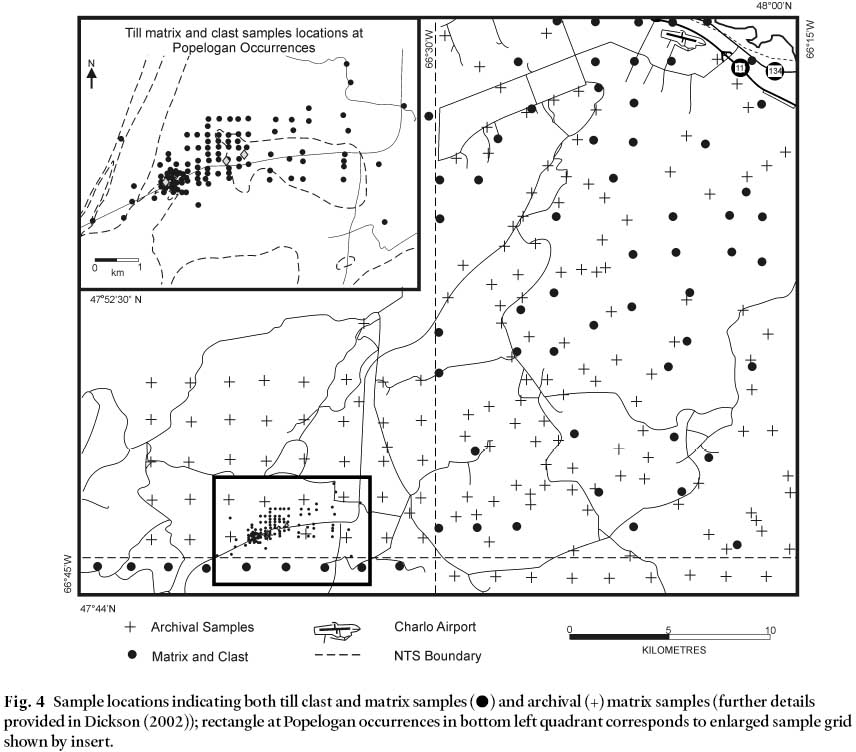
Display large image of Figure 4
20 Exactly 100 g of the <2 mm grain size fraction was used for granulometric analysis. The modified hydrometer method (cf. Bouyoucos 1962) was used to determine the relative proportions of clay, silt, and sand in each sample (see Dickson 2002). The lithology of each pebble of the clast samples was determined on fresh broken surfaces with the aid of a hand lens or microscope, and compared to a reference suite of bedrock samples. The clasts were categorized based on rock type, formation and group, and the relative proportions were determined for each site (Dickson 2002). Pebbles were also examined for mineralization to detect clast dispersal trains from known and unknown mineral occurrences.
Statistical methods
21 Geochemical and lithological analyses were compiled in spreadsheet form and descriptive statistics were performed using Corel® Quattro Pro 9. These data were also gridded and contoured using Surfer® 6.01. Biased or distorted contours resulting from the irregular shape of the study area and the spacing of samples were alleviated by the use of the Kriging geo-statistical method in Surfer® 6.01. Spearman's rank correlation (rs) analysis was performed on the till and humus geochemical data using the Statistical Package for Social Sciences (SPSS 10 for Windows®) to determine the covariance of till and humus components.
OBSERVATIONS AND INTERPRETATIONS
22 Measurements of striae orientation at 40 sites indicate ice movements in three general directions: northeast, east, and southeast, with the most dominant trend towards the northeast. Only one outcrop, located approximately 10 km to the east of the study area, indicated a cross-cutting relationship with striations showing all three ice movements (Fig. 1). This cross-cutting relationship indicates relative ages of the ice movements, from oldest to youngest, of: 1) 160°, 2) 110°, and 3) 010°, which supported the earlier findings of Pronk et al. (1989).
Regional lithology analysis of till clasts
23 Generally, the clast-sized mode indicates a proximal bedrock source, whereas the matrix fraction is often considered to reflect more distal sources (Dreimanis and Vagners 1969, 1971). Till clasts were collected at 171 sites in the study area, 110 of which were located in the vicinity of the Popelogan porphyry-skarn occurrences (Fig. 4). Clast dispersal was delineated by counting the relative abundances of twelve representative rock types (see Dickson 2002). However, the discussion here will be limited to rock types that best demonstrate the dispersal patterns commonly found. These include: sandstone/siltstone, rhyolite, granite/granodiorite, hornfels and mineralized clasts.
24 The Upsalquitch Formation (Fig. 3) is the likely source for most sandstone and siltstone till clasts found in the study area. This formation underlies more than 50% of the western half and much of the northern part of the study area. Clast concentrations of sandstone and siltstone (Fig. 5) are highest (50% to 100%) in till overlying rocks of the Upsalquitch Formation in the western and northern parts of the study area. Concentrations of sedimentary clasts decrease eastward (0% to 25%), particularly east of the contact between the Upsalquitch Formation (sedimentary) and rhyolite and basalt bedrock units lying to the east (Figs. 3, 5). The New Mills Formation occurs at the southeast corner of the study area and is another source for sandstone/siltstone till clasts. Clast concentrations of up to 55% occur overlying this formation, and decrease northwest-ward and northward, apparently indicating dispersal in those directions (Figs. 3, 5). In both cases, eastward of the contact of the Upsalquitch Formation and northward of the New Mills Formation, concentrations of sandstone/siltstone till clasts fall to less than 5% within a 5 km distance down-ice of these source units.
Fig. 5 Percent sandstone and siltstone till clasts with possible bedrock source units indicated by shading (from mapped bedrock geology, Fig. 3). Note the rapid decrease in these till clast lithologies southeastward of the contact (dashed line at edge of shading) between sedimentary bedrock to the northwest and mainly igneous rock units underlying till in the southeast part of the study area.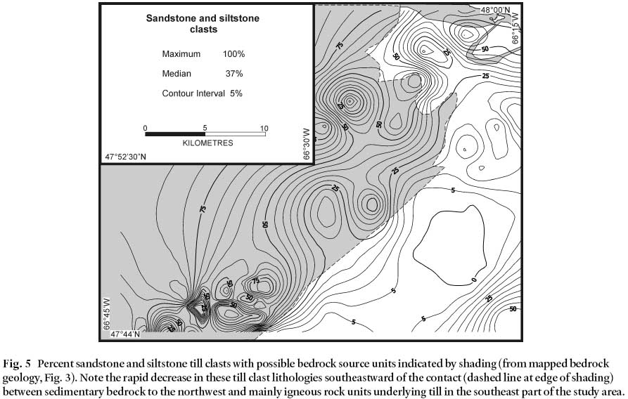
Display large image of Figure 5
25 Rhyolite clasts occur in concentrations of up to 100% overlying source units of the Benjamin Formation in the southeast corner of the study area (Figs. 3, 6). Two large dispersal patterns occur in this area that decrease northward (Fig. 6) to less than 5% in content within 9 km of transport. It is likely that as ice moved across the study area it preferentially eroded outcrops due to the higher elevation of this part of the area (<600 m a.s.l.). Erosion of material at elevations significantly higher than the surrounding terrain manifests itself in longer dispersal patterns than for material entrained at lower elevations (cf. Hornibrook et al. 1993; Parkhill and Doiron 2004).
Fig. 6 Percent rhyolite till clasts with possible bedrock source units indicated by shading (from Fig. 3) The slight bulge of contours towards the northwest is an artifact of the lack of samples in this area.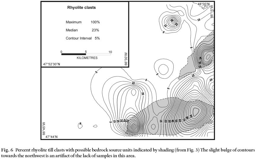
Display large image of Figure 6
26 Rhyolite till clasts increase to 70% over rhyolite bedrock along the easternmost boundary of the study area (Fig. 6). A small bulls-eye shaped occurrence of up to 45% rhyolite clasts occurs in the northeast corner of the study area, 8 km northwest of a major rhyolite source unit. However, this pattern is likely due to minor outcrops of rhyolite in the Bryant Point Formation (Langton 2001b). Northwestward elongation of the westernmost rhyolite clast dispersal pattern results from the lack of data in the northwest corner of the study area.
27 Granite and granodiorite till clasts occur in concentrations up to 100% of the till clast content in some areas (Fig. 7), although these rock types are commonly resistant to erosion. The clasts have apparently been derived from one or more small outcrops of less than 5 km2 that are located throughout the study area and serve as ideal point-sources for dispersal trains. In the southwest part of the study area, concentrations up to 100% of granitic clasts in till are found directly over and to the northeast of the intrusive body associated with the Popelogan skarn occurrences (Fig. 7). These concentrations form two obvious bulls-eye dispersal patterns, one demonstrating a slight northward elongation less than 2 km in length (Fig. 7). While most bulls-eye dispersal patterns of granitic till clasts appear to have been transported slightly northward from source units, three bulls-eye anomalies occur in the northeast part of the study area that may have been displaced eastward and north-eastward (see Fig. 7).
Fig. 7 Percent granitoid (mainly granite and granodiorite) till clasts with possible bedrock source units indicated by shading and mineral occurrences indicated by symbols from Fig. 3.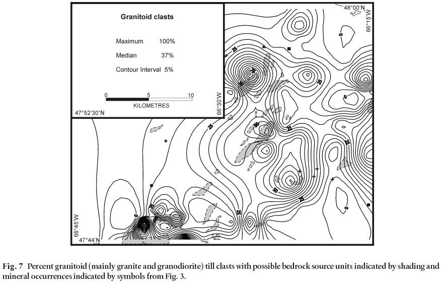
Display large image of Figure 7
28 Hornfels clasts in till were not commonly found in abundance, but their source units could be used to delineate transport from individual point-sources. Three bulls-eye concentrations of hornfels till clasts were identified in the central part of the eastern half of the study area (Fig. 8) that have been displaced up to 7 km eastward of their most probable sources. In the Popelogan area, at the southwestern part of the study area (Fig. 8), dispersal of hornfels till clasts form a pattern elon-gated for 7 km in a north-northwest orientation. This pattern was also found for skarn till clasts (not shown). However, no samples were collected to the northwest of the occurrences; thus the westward influence on the dispersal patterns is most likely a result of computer software interpolation. For example, small concentrations (<11%) of mineralized (pyrite, pyrrhotite, chalcopyrite, molybdenite) till clasts were only found in the vicinity of the Popelogan porphyry-skarn occurrences as distinct eastward-elongated dispersal patterns, less than 3 km in length (Dickson 2002).
Fig. 8 Percent hornfels till clasts. Shaded areas indicate Devonian intrusions (from Fig. 3) related to hornfels-rich zones within the surrounding sedimentary rock units; mineralized occurrences are indicated by symbols from Fig. 3.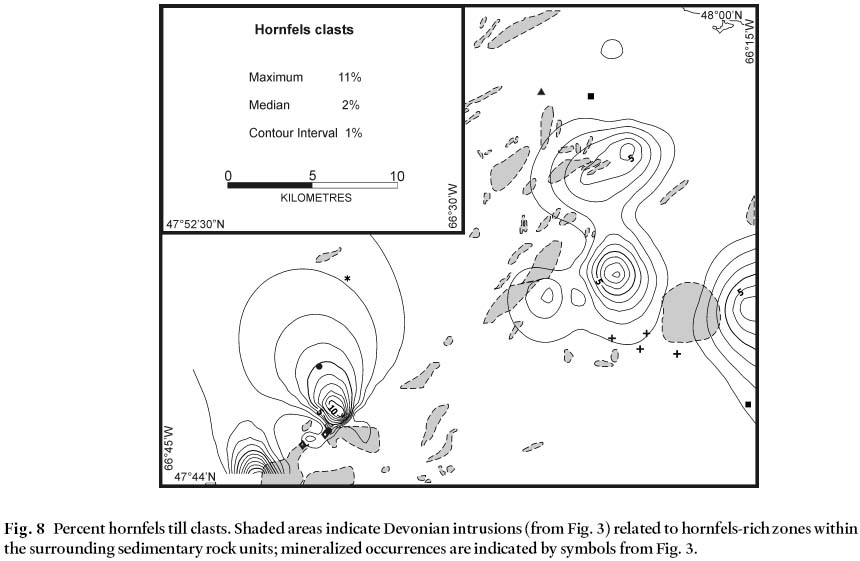
Regional geochemical analysis of till matrix
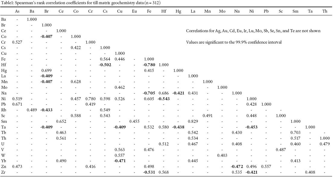
29 Geochemical covariance for the most significant relationships between the 39 elements examined is presented in Table 1, although only a few correlations will be discussed here. Correlation coefficients (rs) with absolute values greater than 0.59, or greater than 35.9% correlation between datum sets (Silk 1979), are considered to be geologically significant (Table 1). No significant correlations were apparent between geochemical and till clast data, or between different clast lithologies (not shown). For the regional till geochemical data, strong positive correlations exist between La and Sm (0.829), Cr and Ni (0.780), Sm and Tb (0.703), Br and Hg (0.699), Hf and Na (0.686), As and Pb (0.671), Ce and Sm (0.652), Co and Mn (0.628), Fe and Ni (0.605), and for Cs and Ni (0.598); strong negative correlations occur for Fe and Hf (-0.780) and Fe and Na (-0.705) (Table 1).
Table1: Spearman's rank correlation coefficients for till matrix geochemistry data (n = 312)
Display large image of Table 1
30 The high correlations amongst the lanthanide elements (Ce, Eu, La, Lu, Sm, Tb, and Yb) are commonly found in till investigations in New Brunswick (e.g., Munn et al. 1996; Broster et al. 2004). Lithophile and rare earth elements have been reported to be elevated slightly in some ablation tills (Stumpf et al. 1997) but this is not considered to be relevant here. However, many factors can affect the correlations or obscure relationships. The strong negative correlation between Fe and Na (-0.705) may be due to the effects of weathering. As materials lose Ca, Mg, K or in this case Na, the elements Al, and Fe would appear to gain (Krauskopf 1967). Weathering might explain the negative Fe– Na correlation if supported by a strong correlation between Al and Fe or a negative correlation between Al and Na, which was not found (Table 1). As expected, elements associated with the Popelogan porphyry-skarn occurrences exhibit weak to moderately strong correlations (e.g., As-Pb, Cu-W, Pb-Zn: Table 1) but are not mutually correlative. Since till is derived from several different sources many causal relationships are lost within the resulting deposit (Broster 1986) while some (e.g., the Br– Hg) correlations may be an artifact of anomalous values of both elements occurring at similar locations (see Dickson 2002).
31 Granulometric composition of the till generally reflects the underlying bedrock and sediment deposits. Sand content of the till varies from 50– 80% with the highest concentrations overlying sandstone and igneous bedrock units. Till clay content is low throughout most of the study area, with two notable exceptions. In the southwest corner of the area, clay increases to around 14%, possibly due to the entrainment of fine-grained pre-glacial valley fill sediments. The till becomes much more clay-rich to the north (50– 70%), especially at elevations below 100 m along the coast, and along major valleys emptying into the Baie des Chaleurs (Figs. 1, 2). This likely reflects incorporation of fine-grained sediments deposited during prior marine flooding of the area.
32 Geochemical data for the till matrix were contoured to enable recognition of dispersal patterns for anomalies and allow comparisons between the spatial distribution of elements. Anomalous concentrations are defined as >95.44th percentile. Geochemical dispersal patterns are relatively shorter than those found for till clasts. Results indicate that concentrations for some elements rarely exceed background values, but the larger anomalous concentrations reflect down-glacier dispersal from known mineralized sources. The Popelogan porphyryskarn occurrences were considered the best target for modeling other dispersal patterns. The Popelogan occurrences are the only mineralized occurrences associated with anomalous concentrations of all of Ag, As, Cu, Mo, Pb, W, and Zn in the overlying till, although the dispersal patterns vary in size and shape for the different elements. Since these are the major elements associated with the largest known mineralized deposit, with the exception of As, they comprise the main elements used to delineate glacier dispersal of the matrix components in this study. Arsenic content is highly susceptible to hydromorphic transport (Paulen 2001) and is not used here to model glacier dispersal. Dickson (2002) reported that high As concentrations (>50 ppm) occur within 0.5 km southward and over a distance of 5 km to the east of the Popelogan occurrences. A second area of anomalous As concentration found in the north-central part of the map area, is coincident with high concentrations of granitic till clasts overlying granite outcrops (Figs. 3, 7). At Popelogan the larger concentration patterns of Ag content (Fig. 9) occur as northward- oriented dispersal from the Popelogan South Zone (Site 1, Fig. 3) and possibly also northeastward dispersal over a distance of about 5 km. Southeastward and eastward dispersal also originates from the Popelogan East site (Site 3, Fig. 3) indicating that Ag may have experienced erosion and dispersal during all three directions of regional ice flow. Another large concentration of Ag occurs as a bulls-eye pattern west of the Benjamin River South D site (site 8, Fig. 3). This concentration pattern may be due to an earlier westward flow event that carried debris from the Benjamin River sites, or more likely, due to the occurrence of an unknown source also associated with a high concentration of granitic clasts (Fig. 7).
Fig. 9 Dispersal pattern for Ag ppm in till matrix with known mineral occurrences (after Fig. 3) and outlines of bedrock contacts from Fig. 3.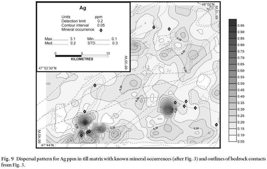
Display large image of Figure 9
33 While the direction of movement may be different at other locations, data from the Popelogan area indicate that anomalous concentrations are likely within 1– 5 km of their bedrock source. For example, the highest concentrations of Cu in the till (up to 630 ppm) are centred over the Popelogan East occurrence (Fig. 10). The dispersal pattern suggests that there, the material was eroded and dispersed northward and then eastward. North of the Popelogan site, the Goulette Brook occurrence is centred within a bulls eye pattern of anomalous Cu concentration (Fig. 10). Other bulls-eye patterns of anomalous concentrations suggest that unknown mineralized sites may be buried within the study area.
Fig. 10 Dispersal pattern for Cu ppm in till matrix with known mineral occurrences (after Fig. 3) and outlines of bedrock contacts from Fig. 3.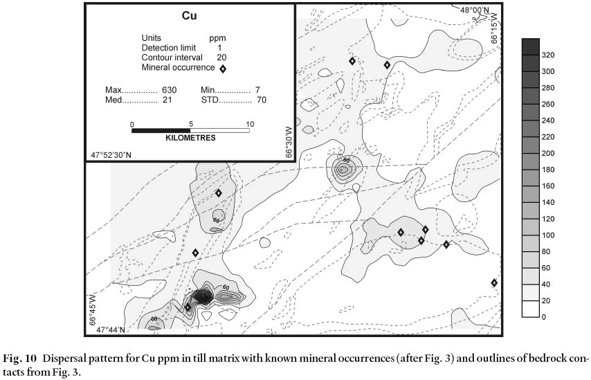
Display large image of Figure 10
34 Northward and eastward displacement of dispersal patterns from Popelogan are demonstrated best by Mo and W (Figs. 11, 12). A slight (1– 2 km) northward dislocation of an eastward dispersal plume is indicated by Mo concentrations (Fig. 11). Tungsten is found in significant concentrations (up to 67 ppm) only at the Popelogan site, in a dispersal pattern that is elongated over a distance of approximately 2 km eastward and displaced about 1 km northward (Fig. 12). This dispersal pattern is very similar to that found for mineralized till clasts (see Dickson 2002). Several dispersal patterns (Figs. 5, 7, 8) indicate that an initial southward- or eastward-dispersal direction was subsequently displaced northward. In the northern part of the study area ice flow may have occurred in both northeastward and northwestward directions as suggested by the rhyolite clast dispersal pattern (Fig. 6). It is possible that there are unknown sources of rhyolite clasts to the southwest of some bulls-eye dispersal patterns. Broster et al. (1997) demonstrate that conglomerate units in some areas can also serve as underlying sources for resistant clast lithologies, originally from much older units that were incorporated into younger conglomerates and subsequently eroded by a glacier. However, no local conglomerate sources have been reported here, or to the west of this area (Carroll 2003; Wilson 2003)
Fig. 11 Dispersal pattern for Mo ppm in till matrix with known mineral occurrences and outlines of bedrock contacts from Fig. 3. The large anomaly southeast of the Popelogan occurrence may be due to earlier southeastward ice flow.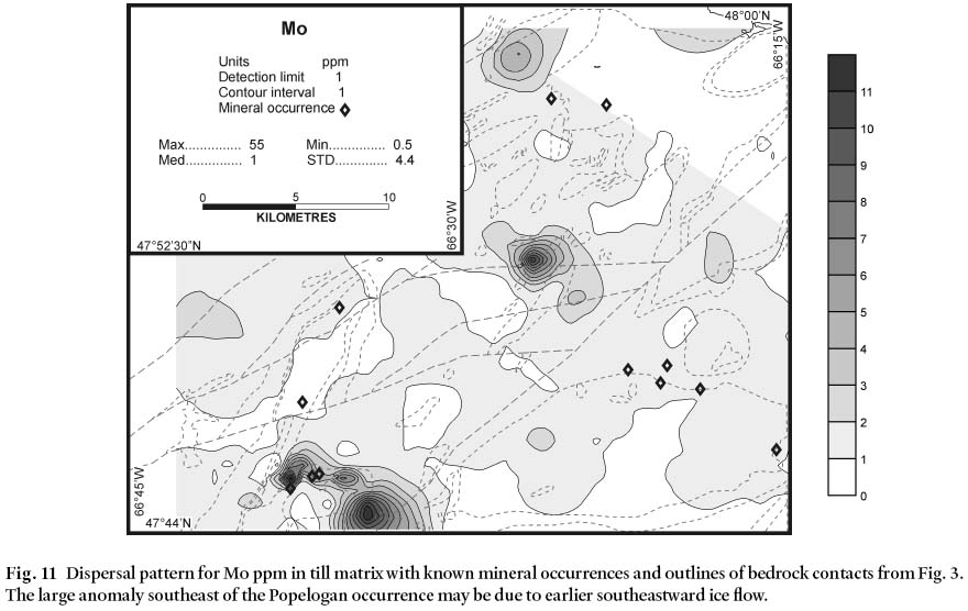
Display large image of Figure 11
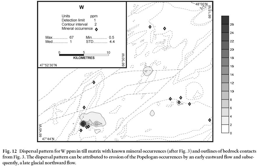
Display large image of Figure 12
35 These observations present a dilemma for identifying unknown sources of geochemical anomalies in the central part of the study area. For example, Ag (Fig. 9) and Cu (Fig. 10) demonstrate anomalous concentrations in till sampled to the west of the Benjamin River occurrences (sites 2, 3; Fig. 3), likely due to a buried unknown source. Two other areas of interest not associated with known deposits were located from the regional study. One area is characterized by coincident, small bulls-eye anomalous concentrations of Cu (145 ppm), Zn (106 ppm), Mo (12 ppm), and W (5 ppm) centred about a fault at 47°52'– 66°26' (Figs. 3, 10, 11, 12, 13). The second is a (regionally) anomalous Zn concentration (160 ppm) also associated with high Cr (410 ppm), Hg (100 ppm), and Mn (920 ppm) at 47°54'– 66°29' (Fig. 13), which is possibly from another buried unknown source of mineralization.
Fig. 13 Dispersal pattern for Zn ppm in till matrix with the major anomalous concentrations occurring north of Popelogan South Zone (from Fig. 3); with other known mineral occurrences also indicated.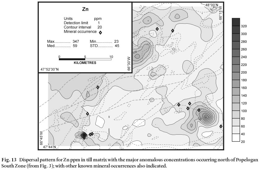
DISCUSSION AND CONCLUSIONS
36 It is an accepted hypothesis that large transport distances (10– 100s km) are required to comminute most rock types to clay-size fragments or so called "terminal grades" (Dreimanis and Vagners 1971). In the study area known mineral occur-rences are reflected as anomalous point source geochemical and clast dispersal patterns in till overlying the known sources or immediately down-ice of them. Examination of dispersal patterns indicates derivation of local material and relatively short transport distances of 1 to 5 km for till geochemical material and less than 10 km for clast transport. These distances are in agreement with those generally found elsewhere in New Brunswick, likely due to erosion under cold-based ice. (e.g., Balzer and Broster 1994; Munn et al. 1996: Stumpf et al. 1997; Parkhill and Doiron 2004). Thus, much of the clay content in the till is probably due to incorporation of pre-glacial residual soils and transported sediment, of which the latter would have been prominent along major valleys.
37 Observations of striations and streamlined landforms support the conclusions of Pronk et al. (1989) of three main directions of ice-flow across the study area. The earliest movement, to the southeast (at around 168°), is rarely preserved in the study area and is only recorded at a few sites. This glacial flow direction represents initial glacial erosion from the advance of local Appalachian ice (Pronk et al. 1989) that transported some glacial debris to locations southeastward of their source. The major eastward flow (110°) is likely correlative to the Jacquet and Baie des Chaleurs flow patterns of Ramptonet al. (1984). Eastward movement has been reported (Chalmers 1886, 1887; Gauthier 1982a, b; Rampton et al. 1984; Pronk 1986, 1987; Bobrowskyet al. 1987; Pronk and Parkhill 1988; Pronk et al. 1989; Lamothe 1992; Parkhill and Doiron 2004) as the dominant direction of flow through the area. This middle event eroded much of the striation evidence of the earlier event, and dispersed eastward some of the previously eroded drift. A later ice-flow direction recognized in the study area is flow toward the northeast (010° to 060°). Striations indicating glacial movement in this latter direction are found predominantly in the northeastern part of the study area (Fig. 1). This event probably represents a shift in flow direction across the study area due to drawdown into the Baie des Chaleurs (Pronk et al. 1989). While this flow phase may have been less erosive than the two earlier flows it did produce new dispersal patterns and dilute or re-direct previous concentrations in some areas obliquely to the previous direction of flow transport. This re-direction of dispersed material occurred at different magnitudes across the study area and under different degrees of erosion, thus developing hybrid tills (cf. Stea and Finck 2001) and palimpsest dispersal trains modified by the later event (Parent et al. 1996). It may be that till was not deposited and re-eroded by the subsequent movements, but that the drift was retained in the ice mass while ice flow was redirected, possibly due to a change in the location of ice-growth or ice drawdown (Stumpf et al. 2000). However, the overall result is general eastward and northward dispersal patterns, albeit of different magnitudes for different areas.
38 Comparison of dispersal patterns across the Popelogan skarn occurrences indicates that some anomalous geochemical concentrations in the study area represent local up-ice sources of unknown mineralization. Dispersal trains are recognizable for only a few kilometres, indicating that where a geochemical dispersal pattern exists, a source is close. However, if the source is buried under till it may be difficult to find due to the complexity of previous ice-movement directions across the area. The best indicators of transport directions are till clasts from known sources, since these can be easily identified in the field and are not susceptible to hydromorphic re-dispersal. Even with subsequent changes in direction of glacier flow, interpretation of local movement vectors is easily made from measurement of dispersal patterns from known point sources.
39 Till clast , granulometric, and geochemical dispersal patterns in the study area mainly reflect the middle eastward and later north and northeastward ice-flow directions recorded by striae. In the southeast corner of the study area eastward-trending striations are dominant, in contrast with northward-oriented clast dispersal trains recorded in the same area (Figs. 6, 7). These data suggest that eastward-moving ice eroded and transported material, but that deposition also occurred during later northward movement. This interpretation may explain the north-south orientated geochemical dispersal patterns (Figs. 9, 10) centered about the Benjamin River occurrences (Fig. 3).
40 Evidence indicates that in areas of multiple ice-flow events: (1) indicators of glacial erosion (striations and streamlined landforms) can be biased towards earlier, highly erosive events (palimpsests) and that (2) till clast dispersal patterns can be more useful than striae or till geochemical dispersal patterns for identifying buried exploration targets (Broster and Huntley 1995).
ACKNOWLEDGEMENTS
Funding was provided by the Geological Surveys Branch of the New Brunswick Department of Natural Resources and Energy (NBDNRE; now DNR). Sample collection and geo-chemical analysis were funded by NBDNRE operating budgets to Michael Parkhill and an NSERC Operating Grant to Bruce Broster. Some of the data presented here represent part of a UNB graduate project by Marni-Lynn Dickson. The authors are grateful to Serge Allard for improvements to figures and to Alan Seaman, Ralph Stea and Ron Pickerill for reviews of an earlier manuscript.REFERENCES
Balzer, S.A., & Broster, B.E. 1994. Comparison of clast and matrix dispersal in till: Canterbury area, New Brunswick. Atlantic Geology, 30, pp. 9– 17.
Bostock, H.S. 1970. Physiographic subdivisions of Canada. In Geology and Economic Minerals of Canada. Edited by R.J.W. Douglas. Geological Survey of Canada, Economic Geology Report 1, pp. 10– 30.
Bobrowsky, P.T., Lamothe, M., & Shilts, W.W. 1987. Late Quaternary glaciation and deglaciation in the Baie des Chaleurs area, northern New Brunswick. Geological Association of Canada/Mineralogical Association of Canada, Program with Abstracts, p. 26.
Bouyoucos, G.J. 1962. Hydrometer methods improved for making particle size analysis of soils. Agronomy Journal, 54, pp. 464– 465.
Broster, B.E. 1986. Till variability and compositional stratification: examples from the Port Huron lobe. Canadian Journal of Earth Sciences, 23, pp. 1823– 1841.
Broster, B.E., & Huntley, D.H. 1995. Effective low -cost reconnaissance drift prospecting in areas of variable terrain: an example from the south-east Taseko Lakes area, central British Columbia. In Drift Exploration in the Canadian Cordillera. Edited by P.T. Bobrowsky, S.J. Sibbick, J.H. Newell, and P.F. Matysek. British Columbia Ministry of Energy, Mines and Petroleum Resources, Paper 1995-2, pp. 121– 126.
Broster, B.E., Munn, M.D., & Pronk, A.G. 1997. Inferences on glacial flow from till clast dispersal, Waterford area, New Brunswick. Géographie physique et Quaternaire, 51, pp. 29– 39.
Broster, B.E., Allaby, G.M., & Pronk, A.G. in 2004. Litho-logical and geochemical dispersal in till: Petitcodiac area, New Brunswick. Atlantic Geology, 40, pp. 169– 188. Carroll, J.I. 2003. Geology of the Kedgwick, Gounamitz River, States Brook, and Menneval map areas (NTS 21 O/11, 21 O/12, 21 O/13, and 21 O/14), Restigouche County, New Brunswick. In Current Research 2002. Edited by B.M.W.
Carroll. New Brunswick Department of Natural Resources, Minerals, Policy, and Planning Division, Mineral Resource Report 2003-4, pp. 23– 57.
Chalmers, R.C. 1886. Surface geology of northern New Brunswick and south-eastern Quebec. Geological and Natural History Survey of Canada, Annual Report, vol. II, Part M, 39 p.
Chalmers, R.C. 1887. Surface geology of north-eastern New Brunswick. Geological and Natural History Survey of Canada, Annual Report, vol. III, Part N, 33 p.
DiLabio, R.N.W. 1990. Glacial dispersal trains. In Glacial Indicator Tracing. Edited by R. Kujansuu and M. Saarnisto. Balkema, Rotterdam, pp. 109– 122.
Dickson, M.L. 2001. Drift prospecting and Quaternary geology in the Atholville and Charlo map areas, northern New Brunswick. Unpublished M.Sc. thesis, University of New Brunswick, 170 p.
Dickson, M.L. 2002. Drift prospecting and Quaternary geology in the Atholville and Charlo map areas, northern New Brunswick. New Brunswick Department of Natural Resources and Energy; Minerals, Policy, and Planning Division, Open File 2002-9, 171 p.
Dreimanis, A. 1976. Tills: their origin and properties. In Glacial Till: An Interdisciplinary Study. Edited by R.F. Legget. Royal Society of Canada, Special Publication 12, pp. 11– 49.
Dreimanis, A., & Vagners, U.J. 1969. Lithologic relation of till to bedrock. In Quaternary Geology and Climate. Edited by H.E. Wright Jr. Vol. 16 of the Proceedings of the VII Congress of the International Association for Quaternary Research. National Academy of Science, Washington, pp. 93– 98.
Dreimanis, A., & Vagners, U.J. 1971. Bimodal distribution of rock and mineral fragments in basal till. In Glacial Till: An Interdisciplinary Study. Edited by R.F. Legget. Royal Society of Canada, Special Publication 12, pp. 237– 250.
Fyffe, L.R., & Fricker, A. 1987. Tectonostratigraphic Terrane Analysis of New Brunswick. Maritime Sediments and Atlantic Geology, 23, pp. 113– 123.
Gauthier, R.C. 1982a. Quaternary geology of northern New Brunswick. Geological Survey of Canada, unpublished manuscript.
Gauthier, R.C. 1982b. Surficial deposits, northern New Brunswick. Geological Survey of Canada, Open File Report 856, 9 maps.
Hornibrook, E.R.C., Broster, B.E., Gardiner, W.W., & Pronk, A. G. 1993. Glacial dispersal of garnets and other heavy minerals in till: Miramichi area, New Brunswick. Exploration Mining Geology, 2, pp. 345– 353.
Irrinki, R.R. 1990. Geology of the Charlo area; Restigouche County, New Brunswick. New Brunswick Department of Natural Resources and Energy, Mineral Resources, Report of Investigation 24, 118 p.
Krauskopf, K.B. 1967. Introduction To Geochemistry, Mc-Graw Hill Publishers, 721 p.
Lamothe, M. 1986. Reconnaissance geochemical sampling of till, south-central Miramichi Zone, New Brunswick. In Current Research, Part B, Geological Survey of Canada, Paper 86-1B. pp. 279– 287.
Lamothe, M. 1992. Pleistocene stratigraphy and till geochemistry of the Miramichi Zone, New Brunswick. Geological Survey of Canada, Bulletin 433, 58 p.
Langton, J.P. 2001a. Geology of the South Charlo River area (NTS 21O/16d), Restigouche County, New Brunswick, New Brunswick Department of Natural Resources, Minerals, Policy, and Planning Division, Plate 2001-27, scale 1:20 000.
Langton, J.P. 2001b. Geology of the Balmoral area (NTS 21O/16e), Restigouche County, New Brunswick, New Brunswick Department of Natural Resources, Minerals, Policy, and Planning Division, Plate 2001-28, scale 1:20 000.
Munn, M.D., Broster, B.E., & Pronk, A.G. 1996. Geo-chemical dispersal in till: Waterford area, New Brunswick. Atlantic Geology, 32, pp. 269– 279.
Parent, M., Paradis, S.J., & Doiron, A. 1996. Palimpsest glacial dispersal trains and their significance for drift exploration. Journal of Geochemical Exploration, 56, pp. 123– 140.
Parkhill, M.A., & Doiron, A. 2004. Quaternary geology of the Bathurst Mining Camp and implications for base-metal exploration using drift prospecting. Economic Geology Monograph 11, pp xxx– xxx.
Paulen, R.C. 2001. Glacial transport and secondary hydro-morphic metal mobilization: examples from the southern interior of British Columbia, Canada. In Drift exploration in glaciated terrain, Edited by M.B. McClenaghan, P.T. Bobrowsky, G.E.M. Hall, and S.J. Cook. Geological Society of London, Special Publications, 185, pp. 323– 337.
Pronk, A.G. 1986. Till geochemistry of the Tetagouche Lakes area (21 O/9), New Brunswick. New Brunswick Department of Forest, Mines, and Energy; Mineral Resources Division, Geological Notes Series, PM 86-216, 10 p.
Pronk, A.G. 1987. Surficial geology and till geochemistry of the Upsalquitch Forks (21 O/10) map area (with emphasis on gold distribution in tills). New Brunswick Department of Natural Resources and Energy, Mineral Resources Division, Geological Notes Series 87-47, 8 p.
Pronk, A.G., & Parkhill, M.A. 1988. Surficial geology and till geochemistry (Au, As, Sb, Hg, Bi, Cu, Pb, Zn, Ag, Mn, Fe, Co, Ni, Mo) of the Atholville (21 O/15) map area and part of Escuminac (22 B/1) and Oak Bay (22 B/2) map areas, New Brunswick. New Brunswick Department of Natural Resources and Energy, Mineral Resources Division, Geological Notes Series PM 88– 10, 7 p.
Pronk, A.G., Bobrowsky, P.T., & Parkhill, M.A. 1989. An interpretation of late Quaternary glacial flow indicators in the Baie Des Chaleurs region, northern New Brunswick. Géographie physique et Quaternaire, 43, pp. 179– 190.
Quartermain, R.A. 1981. Popelogan Lake, New Brunswick, property appraisal and proposal for further work. Unpublished M.Sc. Thesis, Queens University, Kingston, Ontario, 79 p.
Rampton, V.N., Gauthier, R.C., Thibault, J., & Seaman, A.A. 1984. Quaternary geology of New Brunswick. Geological Survey of Canada, Memoir 416, 77 p.
Rose, D.G. & Johnson, S.C. 1990. New Brunswick computerized mineral occurrence database. New Brunswick Department of Natural Resources and Energy, Minerals and Energy Division, Mineral Resource Report 3, 69 p.
Ruitenberg, A.A., Fyffe, L.R., McCutcheon, S.R., St. Peter, C.J., Irrinki, R.R., & Venugopal, D.V. 1977. Evolution of pre-Carboniferous tectonostratigraphic zones in the New Brunswick Appalachians. Geoscience Canada, 4, pp. 171– 181.
Shilts, W.W. 1976. Glacial till and mineral exploration. In Glacial Till, An Interdisciplinary Study. Edited by R. F. Legget. Royal Society of Canada, Special Publication, 12, pp. 205– 223.
Silk, J. 1979. Statistical concepts in geography. George Allen and Unwin, London, 276 p.
Stea, R.R., & Finck, P.W. 2001. An evolutionary model of glacial dispersal and till genesis in Maritime Canada. In Drift Exploration in Glaciated Terrain. Edited by M.B. Mc-Clenaghan, P.T. Bobrowsky, G.E.M. Hall, and S.J. Cook. Geological Society of London, Special Publications, 185, pp. 237– 265.
Stumpf, A.J., Broster, B.E., & Seaman, A.A. 1997. Litho-logical and geochemical dispersal in till: McAdam area, New Brunswick. Atlantic Geology, 33, pp. 31– 42.
Stumpf, A.J., Broster, B.E., & Levson, V.M. 2000. Multi-phase flow of the late Wisconsinan Cordilleran ice sheet in western Canada. Geological Society of America Bulletin, 12, pp. 1850– 1863.
Van Staal, C.R., & Fyffe, L.R. 1995. Dunnage Zone - New Brunswick. In Chapter 3 of Geology of the Appalachian-Caledonian Orogen in Canada and Greenland. Edited by H. Williams. Geological Survey of Canada, Geology of Canada, No. 6, pp. 166– 178.
Veillette, J.J., & Nixon, F.M. 1982. Saprolite in the Big Bald Mountain area, New Brunswick. In Current Research, Part B, Geological Survey of Canada, Paper 82-1B, pp. 63– 70.
Williams, H. 1979. Appalachian Orogen in Canada. Canadian Journal of Earth Sciences, 16, pp. 792– 807.
Wilson, R.A. 2000a. Geology of the Popelogan Lake-Lost Pine area (NTS 21 O/15a and b), Restigouche County, New Brunswick. In Current Research 1999. Edited by B.M.W. Carroll. New Brunswick Department of Natural Resources and Energy, Minerals and Energy Division, Mineral Resource Report 2000-4, pp. 91– 136.
Wilson, R.A. 2000b. Geology of the Popelogan Lake area (NTS 21 O/15a), Restigouche County, New Brunswick. New Brunswick Department of Natural Resources and Energy, Minerals and Energy Division, Plate 2000-25.
Wilson, R.A. 2000c. Geology of the Lost Pine Lake area (NTS 21 O/15b), Restigouche County, New Brunswick. New Brunswick Department of Natural Resources and Energy, Minerals and Energy Division, Plate 2000-26.
Wilson, R.A. 2003. Geology of the Campbellton area (NTS 21 O/15), Restigouche County, New Brunswick. New Brunswick Department of Natural Resources; Minerals, Policy and Planning Division, Plate 2003-15.
Woods, G.A. 1993 Skarn type base metal deposits in the McKenzie Gulch, Patapedia, and Popelogan areas. In Guidebook to the Porphyry Copper and Copper Skarn Mineralization in Northern New Brunswick and Gaspé, Quebec. Edited by S. R. McCutcheon and G. A. Woods. Trip #1 of Bathurst ‘ 93: 3rd Annual Field Conference, Geological Society of CIM, pp. 42– 53.
Editorial responsibility: Ron K. Pickerill