Articles
Visualizing Labrador: Maps, Photographs, and Geographical Naming in Mina Hubbard’s A Woman’s Way through Unknown Labrador
Wendy RoyUniversity of Saskatchewan
1 IN 1908, MINA HUBBARD published a book about a two-month canoe journey she had made three years earlier through northern Labrador. Although well received by geographical authorities and general readers, A Woman’s Way through Unknown Labrador: An Account of the Exploration of the Nascaupee and George Rivers was overshadowed by more conventional books of adventurous travel, especially the narrative describing her husband’s death on a previous expedition.1 Contemporaneous reviews of her book often characterized Mina Hubbard as a “charming and plucky little woman” whose journey honoured her husband’s memory (Millais 402-03; see also “Love’s Labour”), and beginning in the 1960s, that characterization was taken up and elaborated upon in several popular histories (Cooke, 1960; Berton, 1978; Davidson and Rugge, 1988). Only recently have Hubbard’s book, her journal articles, and the travel diary on which they were based begun to be recognized as valuable literary, as well as historical, artifacts. That revaluation includes several critical studies (Grace 2000, 2001; LaFramboise 2001), the republication of A Woman’s Way, and, for the first time, the publication of Hubbard’s travel diary, accompanied by a detailed biography.2 As these books and articles demonstrate, Hubbard’s journey and resulting narratives provide a radical revision of what travel theorist Karen Lawrence calls the “Western cultural truism that Penelope waits while Odysseus voyages” (ix). Hubbard’s story is that of an early twentieth-century Penelope whose Odysseus did not return from his voyage, and whose death set the stage for her decision to voyage in his stead, to tell her own tale, and to map and thus make a claim to the physical space of the Ungava Peninsula.
2 This essay focuses on a relatively uninvestigated aspect of Hubbard’s expedition and book: intersections between her photographs and her map on the one hand, and textual depictions of Labrador landscape and topography on the other. A Woman’s Way includes forty-nine black and white photographs and an eighteen- by twenty-inch two-colour map. In photos and map as well as text, Hubbard depicted and named the landscape in several distinctly different but often overlapping ways. As the full title of her book indicates, she viewed and represented herself as an explorer, albeit an unusual one because of her gender. Her mapping, naming, and illustrating of Labrador thus encompassed the explorer’s conventional obligation to portray himself (or herself) as the first to arrive at key points along his or her journey and first to pass on geographical and ethnological information to outsiders. Even before her book was published, Hubbard’s articles had demonstrated her partial adoption of masculine models: in an article published in the American and Manchester Geographical Society journals, she called Labrador a “virgin field for the explorer” (530; 170). But in A Woman’s Way, Hubbard also personalized and domesticated the landscape, equating it with family (especially her dead husband) and creating toponyms that reflected those personal connections.
3 Maps and illustrations of landscape are intrinsic to travel narratives, since even a travel book that has no illustrations to accompany it records the implicit mapping of a route taken through a particular landscape. Yet charts and photos such as Hubbard’s have received surprisingly little critical attention. One reason is a theoretical gap, only now being addressed, that results in visual accompaniments to travel narratives being treated as objective or self-evident representations of places visited at the same time as the narratives themselves are re-examined for their political underpinnings. Travel writing that was traditionally identified, in James Clifford’s words, as “heroic, educational, scientific, adventurous, ennobling” (105) has recently been reread as stemming instead from economic or imperialist motives. A similar critical scrutiny is evident in studies that analyze cartography’s complicity with imperialism, rather than simply celebrating what Alison Blunt and Jane Wills call “exploration, ‘discovery’, and heroic explorers and geographers” (193). Feminist geographers have also investigated the gendered nature of exploration and mapping, demonstrating that geographical knowledge has long been perceived as a masculine prerogative because of limits to both women’s access to geographical knowledge and their ability to travel independently.
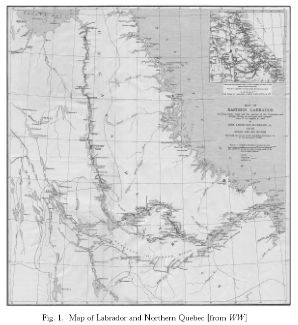
4 Hubbard’s book is the account of a 576-mile canoe journey she made into the interior of Labrador and northern Quebec with four male Métis, Cree, and Inuit guides. She and George Elson, Job Chapies, Joseph Iserhoff, and Gilbert Blake left Northwest River Post in Labrador (then, together with Newfoundland, an independent British colony) on 27 June 1905 in two canoes. They travelled upstream along the Naskaupi River, through Lake Michikamau and Lake Michikamats to the height of land, then downstream along the George River, arriving 27 August at George River Post in the Ungava District of Canada’s Northwest Territories (now northern Quebec; see route, fig. 1).3 Hubbard’s motives for organizing the trip were relational; she was completing a failed expedition begun two years earlier by her husband, American adventure writer Leonidas Hubbard Junior, that had resulted in his death by starvation after he followed inadequate maps and tried to navigate up the wrong river. Initially, Mina Hubbard had planned only to publish Leonidas’s travel diary, along with an account of his death by George Elson, who had also been the guide on his tragic 1903 expedition.4 Instead, these materials became appendices to her own narrative and, together with her photos and map, helped to revise the cultural truism that women do not contribute to geographical knowledge.
Fig. 1. Map of Labrador and Northern Quebec [from WW ]
Display large image of Figure 1
5 The map that Hubbard produced with the aid of the American Geographical Society was recognized by several geographical authorities as the first detailed and accurate chart of that area of Labrador. Although the first review of Hubbard’s book in the Royal Geographical Society’s Geographical Journal notes that the map “makes no claim to be other than the result of pioneer work,” mainly because Hubbard took observations for latitude but not for longitude (“Recent Crossing” 349), the second review points out that “an examination of the map … shows the value of her work, especially in the extraordinary divergence between her observations of the course of the Nascaupee and its course as previously conjectured” (“Labrador” 614). W.H.W. of the Journal of the Manchester Geographical Society calls the map “excellent” and the book a “splendid addition to the knowledge of Labrador” (133) and “of great geographical value” (134).5 He even gives her head guide, Elson, a sort of backhanded credit, as having a “name, which while it can never figure in the list of those who have directly added to the geographical knowledge of the country, must, so long as Mrs. Hubbard’s work lasts, and longer, command the admiration of all” (133). (Presumably, Elson cannot be given direct credit because he is a hired guide and did not write the book or draw the map, although his work allowed Hubbard to do so.) Hubbard was invited to deliver two lectures about her travels to the Royal Geographical Society in England, and her article, map, and photographs were published in the journals of both the American and Manchester Geographical Societies.6 Later writers about Labrador, including William Duncan Strong (15) and William Cabot (Introduction 27-28; In Northern Labrador 10), considered her maps to be major accomplishments, since they showed “what geographers had supposed were two distinct rivers, the Northwest and the Nascaupee, to be one and the same” (WW 236).
6 Several contemporaneous reviewers also praised Hubbard’s many photographs, taken using a folding pocket Kodak and a panoramic Kodak. The portable Kodak, invented by George Eastman just seventeen years before her journey, made it possible for travellers to carry cameras with them on arduous trips. The Geographical Journal called Hubbard’s photos “excellent” (“Labrador” 614); The Spectator claimed that they “are as beautiful as they are rare” (“A Woman Explorer” 473); and the Western Mail noted that “the only keen regret that the book causes us [is] that amongst the many admirable photographs there is none of the caribou migration” (“Through Unknown Labrador” n.p.). Hubbard was delighted with the photos: she wrote in her diary, “I have never seen such pictures anywhere as some of them are. I think there are none in existence can equal some of them” (MH Diary 25 Dec.). But she also regretted what the photos did not show, such as the caribou and the colours of the landscape (MH Diary 16 Aug., 19 Jul.). Although Hubbard’s photos are of much higher quality than most travel illustrations of the era, since their publication almost one hundred years ago they have been studied only briefly in terms of their contribution to the “structural multiplicity” of her text (Grace, “Woman’s” 196; see also see also Grace’s introduction to WW ).
7 Sara Mills suggests that women travellers, like men, often included photographs in their travel narratives in order to prove that they did indeed travel where they claimed to have gone (113). Hubbard intended her photos to serve as a record of her journey and as concrete evidence of the topography of the countryside through which she travelled and the ethnography of the peoples she encountered.7 Her photographic images evince the motives of the early twentieth-century ethnographer and explorer as they provide “proof” regarding the features of the Labrador landscape, the First Nations people she met, her four guides, and herself.
8 A number of Hubbard’s photos illustrate the waterways her expedition navigated. “Up the Fierce Nascaupee” and “Shooting the Rapids” demonstrate the challenges provided by the Naskaupi and George Rivers for both navigation and mapping (28, 220), while “Solitude (Seal Lake)” and “Great Michi-kamau” picture the wide expanses of water that sometimes had to be crossed (106, 266). Other photos show the changing geographical features of the surrounding countryside, as the expedition travelled through bush into barrenlands. Thus while “On into the Wilderness” shows a trail leading into a thick stand of pines (38), “Deep Ancient Valleys” presents a wide watercourse strewn with enormous boulders and surrounded by barren hills (4).
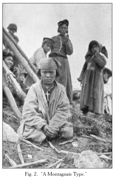
9 Another category of photos illustrates ethnographic details of the two Innu groups her party met, whom she called the Nascaupee and the Montagnais in accordance with ethnographic practice of the day. An especially striking photo, captioned “A Montagnais Type” (fig. 2), shows what is probably a girl wearing what Hubbard describes as a traditional headscarf, with a large crucifix around her neck. In contrast to many ethnographic photos of “types,” this person is pictured looking directly at the camera, as are several others in the background. Thus, although the viewer is invited to gaze, the subjects of the photograph are allowed to gaze back, a reciprocal effect uncommon in ethnographic photography (Maxwell 13; see also Kaplan 9-10). Hubbard writes, in fact, that “the types were various as those to be found in other communities ranging from the sweet and even beautiful face to the grossly animal like” (191). She describes the Innu men as having “markedly Indian faces,” and writes about them alternately as noble savages — “tall, lithe, and active looking, with a certain air of self-possession and dignity which almost all Indians seem to have” (203) — and as a collective and stereotyped “mind” that is focused mostly on gifts of tobacco from Hubbard’s party — “I could not know how far the Indian mind had been influenced, in gauging the distance [to George River Post], by a desire to reduce to the smallest possible limit the amount of tobacco the men would need to retain for their own use” (212-13). Photography theorist Anne Maxwell contends that “most of the photographs of colonized peoples produced in the late colonial period … empowered Europeans by upholding the binary opposition of civility versus savagery” (14). Hubbard’s photos are less rigid in that they show a traditional way of life — caribou skin clothing and tents — existing simultaneously with encroaching civilization in the form of trade and religion — cloth kerchiefs and crucifixes.
Fig. 2. “A Montagnais Type.”
Display large image of Figure 2
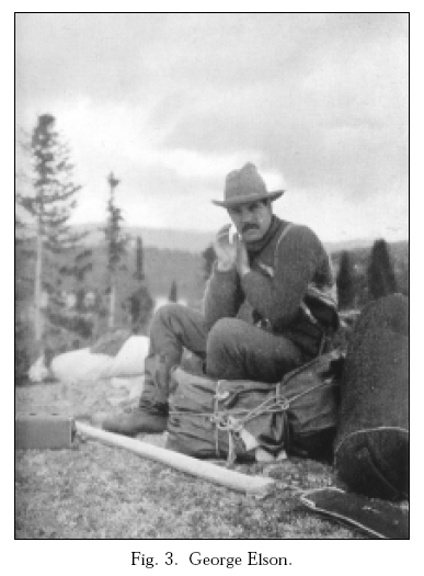
10 Not all of Hubbard’s photographs of people are ethnographic records; some are designed to illustrate the travelling companions she describes so eloquently in her narrative and to provide a record of the work necessary for the success of such an expedition. Thus she includes photos of her four guides canoeing, traversing rapids, skinning caribou, smoking meat, cooking bannock, and portaging canoes and supplies. One portage photo, ironically labelled “The White Man’s Burden” (18), is placed in the introduction to illustrate a claim its author, William Cabot, makes that large amounts of provisions are necessary when white men, but not First Nations men, travel. Hubbard’s photographic portraits of the men who accompany her give them individual faces as well as names (although the caption under Elson’s portrait is the only one that includes his family name; see fig. 3). Sherrill Grace comments that the portraits “are remarkable because they grant visual presence and individual importance” to Native men (“Woman’s” 196). Elson and Job Chapies in particular are pictured looking directly at the camera, again conferring them some power in the encounter with the viewer. Even the portraits, though, show the men in relation to their work: Elson sitting among a pile of portaged supplies; Chapies paddling the canoe, his pipe clenched tightly in his mouth (60); Iserhoff holding a pair of freshly killed ducks (94); and Blake laughing as he throws a piece of wood on the fire (172).
Fig. 3. George Elson.
Display large image of Figure 3
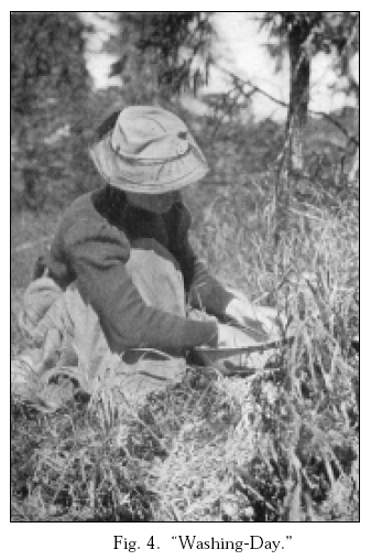
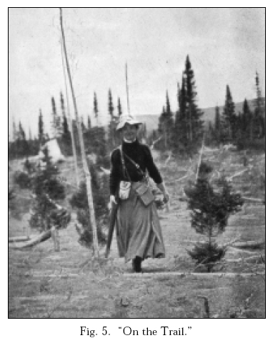
11 Although Hubbard appears in some of the images and although Elson notes in his diary that he took her photo several times (6, 9 Aug.), the title page notation, “By Mrs. Leonidas Hubbard, Junior / With Portraits and Illustrations,” implies that she is the author of all the book’s photographs. Indeed, her contribution even to photographs in which she appears was likely substantial, since she probably set up most of the scenes and thus retained control over the way in which she was portrayed. Images of Hubbard illustrate two conflicting characterizations with which her text also grapples: that her behaviour on the journey was properly feminine, and that she was at the same time the expedition leader and chief explorer.8 Thus Hubbard is portrayed in three photos engaged in typical womanly activity — washing clothing in a basin (fig. 4); sitting in the centre of a loaded but stationary canoe, her face covered by mosquito netting (100); and cooking before a fire, even though she seldom cooked (142). In contrast, two other photographs stress her active part in the expedition — striding along the trail carrying what appears to be a rifle (fig. 5) and standing in a windblown camp while the men recline at her feet (152). Hubbard’s book also includes two photographs that emphasize attainment of “firsts” as explorer: her contact with the Innu and her arrival at her planned destination.
Fig. 4. “Washing-Day.”
Display large image of Figure 4
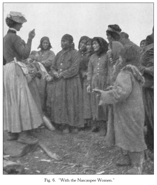
12 The photograph of Hubbard with the Innu pictures her standing on a rock, her hand raised and her index and middle fingers pointed, apparently lecturing to (or at least talking to) the women (fig. 6). She is represented not only as the first white woman to speak to the Innu of this area but, in this photograph, as dominant in terms of her physical position. She stands above them; her raised hand and pointed fingers indicate that she is saying something of import. Contact and communication with First Nations is an essential part of the explorer’s work and, the photo implies, such contact and communication was successful. Her narrative, in contrast, indicates that communication was difficult and incomplete, since she could not understand or speak Innu-aimun. She writes, “I could make almost nothing of what they said, and when I called George to interpret for me they seemed not to want to talk” (211).9
Fig. 5. “On the Trail.”
Display large image of Figure 5
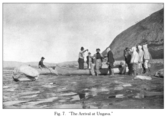
13 Hubbard’s photograph of her group’s arrival at George River Post at the end of their journey emphasizes that her race and gender allow her to make another claim to be “first” (fig. 7). She writes that Mrs. Ford, the blue-eyed factor’s wife, greeted her with the words, “You are very welcome, Mrs Hubbard. Your’s is the first white woman’s face I have seen for two years” (233-34). Hubbard is pictured, as the narrative describes, wearing her waterproof sealskin boots, using a paddle as support against the treacherous mud, and being helped out of the canoe by factor John Ford. As her text also indicates, all four of her travelling companions are still in the two canoes. But unlike the spontaneity implied by the narrative and by the photo caption “The Arrival at Ungava,” this seemingly spontaneous scene has been carefully orchestrated. As Elson notes in his diary entry of 7 September, their arrival on 27 August was restaged eleven days later in order that a photograph could be taken.10 During that restaging, the men waited in the canoes while Hubbard was the first to set foot on land at their destination. As expedition leader and chief explorer, Hubbard had to be portrayed as the first of her expedition to step on the ground. Although she was short of film, she had earlier made a point of saving one exposure so that she could document this occasion (MH Diary 26 Aug.).
Fig. 6. “With the Nascaupee Women.”
Display large image of Figure 6
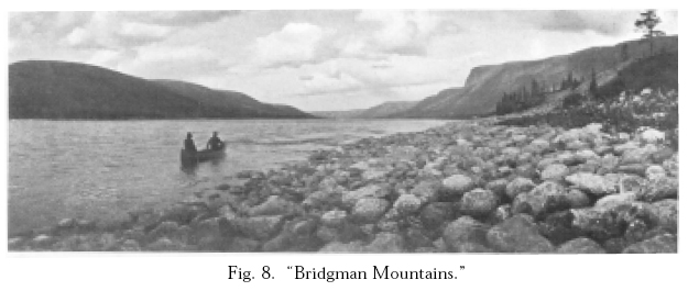
14 Hubbard’s map provides perhaps the strongest statement of her claims to have arrived “first” as a Labrador explorer (fig. 1). As her article for the two geographical journals emphatically states, “The map which this article is intended to accompany sets forth the work I was able to accomplish” (531; 171). Hubbard’s book and travel diary record the fact that as well as taking photos, she made frequent measurements for her map with compass, sextant, and artificial horizon, and kept detailed notes on topography. Hubbard not only measured, located, and described topo-graphical features such as rivers, lakes, waterfalls, and mountains; she also named them. A Woman’s Way is sprinkled with statements such as “away ahead were the blue ridges of hills with one high and barren, standing out above the rest, which I named Bald Mountain” (84), and “George pointed out the ridge of mountains away to the south-west … and I named them Lion Heart Mountains” (102-03). At times she emphasizes her act of naming, but at other times she simply includes her own names for geographical features, such as on the page in which she describes Bridgman Mountains and Helen Falls (226) but does not indicate that she has chosen those toponyms in honour of publisher Herbert L. Bridgman and his wife, Helen. Her diary entry of the day she passed by those geographical features indicates that she was thinking of her friends; she writes, “The Bridgmans will be delighted with my success” (25 Aug.).
Fig. 7. “The Arrival at Ungava.”
Display large image of Figure 7
15 Hubbard labelled some geographical features according to their appearances, filtered through her own cultural knowledge. In Labrador, she named not only Bald Mountain but also Santa Claus Mountain (“the outline of its rugged top looked as if the tired old fellow had there lain down to rest” [105]); Mount Pisa (“distinctly leaning towards the east” [106]); and Lookout Mountain (“The view from the mountain top was magnificent in all directions” [121]). In Quebec, she named Slanting Lake (which “appeared to dip … from one side to the other” [221]); the Hades Hills (which looked to her like the entrance to the Greek mythological underworld [220-21]); and Pyramid Mountain (“It reminds me of an Egyptian pyramid” [223]).
16 The photographs that she took of these geographical features provide even more documentary evidence that she had been where she claimed to have been and that many of the place names on her map were of her choosing. Her book includes photos of Bridgman Mountains (fig. 8) and of Maid Marion Falls (124), named after her niece. As these examples indicate, Hubbard inscribed the landscape in travel diary, book, photos, and map in a distinctly personal and often relational way. In particular, she conflated her sorrow about her husband’s death, and a related belief that he accompanied her in spirit on this journey, with her feelings about the landscape. She wrote, “I do not feel far from home but in reality more at home than I have done since I knew my Laddie [her name for Leonidas] was never coming back to me” (23 Jul.; see also WW 113-14). After Elson pointed out the mountains he had crossed with her husband (102-03), she commented in her diary that “the grander and more beautiful it grows the more I hunger for the one who made all things beautiful so much more beautiful by the spirit which he breathed into them” (16 Jul.).
Fig. 8. “Bridgman Mountains.”
Display large image of Figure 8
17 Often passages in her book are more metaphoric than those in her diary in order to be less directly personal, and thus make more use of the landscape as a means of expression. She writes, for example,the sun came out again, throwing a golden glow over all. Clouds lay like delicate veils along the hill-sides, sometimes dipping almost to their feet.… It was very wild and beautiful, but as an exquisite, loved form from which the spirit has fled. The sense of life, of mystery, and magic seemed gone, and I wondered if the time could come when beauty would cease to give me pain. (95)Her diary entry for the same day, 10 July, deals more explicitly with her feelings about her husband, his death, and her subsequent assumption of his mantle:It is all so wild and grand and mysterious and how his heart would beat hard with pride and joy in it all if he could be here. Along the edge of the bank I watched it for some time thinking, thinking. So very, very beautiful yet lacking that which completes and perfects. I have not his spirit, not that of the true explorer. (10 Jul.)Hubbard’s feelings of inadequacy as an explorer, in comparison with her husband, and of sorrow at his loss thus are essential components of her descriptions of landscape. At the same time, because she feels her husband to be present in the land in which he died, the barren landscape becomes less threatening and more the home that Hubbard implies can be found in the metaphorical presence of her husband.
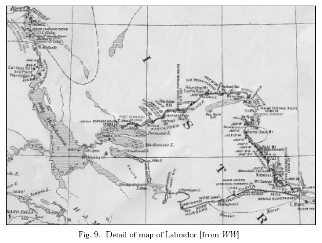
18 The toponyms on Hubbard’s map contribute to her personalization and domestication of the landscape as they evoke her husband and other relatives and friends. In what is now Quebec, Mina named Hubbard Lake to honour her husband. In Labrador, she repeated the memorialization of Leonidas begun by his travelling companion, Dillon Wallace, by including on her map the labels Disappointment Lake, Windbound Lake, and Mount Hubbard, first published in Wallace’s 1905 book The Lure of the Labrador Wild (see detail of Hubbard’s map, fig. 9). She changed the name of Wallace’s Kipling Mountains to Lion Heart Mountains to honour her husband’s courage. She named Cabot Lake for the man who defended her husband’s expedition and then wrote the introduction to her book, Ford River and Ford Island for the George River Post factor, and Elson Lake for her head guide. Her inscription of the name of a Métis man on the landscape of Labrador is indicative of the esteem in which she held Elson and the egalitarian nature of her personal politics.
Fig. 9. Detail of map of Labrador [from WW]
Display large image of Figure 9
19 Hubbard also recorded the first names of women friends and family members by writing them onto the land. Two geographical features that she almost certainly named for friends are Helen Falls and Point Lucie. Helen Bridgman asserts in her book Within My Horizon that the falls were named after her (81), and I speculate that Point Lucie was named for the wife of Hubbard’s friend and minister, James Sawyer. The naming of Point Lucie follows Hubbard’s practice of labelling large geographical features for male friends (Bridgman Mountains and Mount Sawyer) and giving nearby smaller geographical features the first names of their wives (Helen Falls and Point Lucie). On the day Hubbard’s group travelled past a high sandy point of land and a nearby mountain, Hubbard wrote in her diary, “Named it Pt. Lucie and [the mountain] Mt. Sawyer”11 (29 Jun.). Hubbard acknowledged James Sawyer in her preface and wrote near the end of her trip that she would be very glad to see “the Sawyers” (25 Aug.).
20 Anne Hart, former director of the Centre for Newfoundland Studies, has identified a number of lakes and falls that Hubbard labelled with the first names of her nieces: Dorothy, Marie, Orma, and Agnes Lakes, and Gertrude and Maid Marion Falls.12 Hubbard probably also named one lake after herself — Adelaide Lake, just south of Hubbard Lake, commemorating what on her birth certificate is listed as her second name.13 Other geographical features on her route that she may have named for unidentified women friends and family members include Mabelle Island, Mount Elizabeth, and Isabella Falls. The only one of these geographical features that Hubbard mentions naming, in her diary, is a “beautiful evergreen covered island … which we named Mabelle I.” (1 Jul.). She does not identify the source of the name and, indeed, her use of the first-person plural pronoun indicates that “Mabelle” may have been a friend or relative of one of her travelling companions. Such wording also suggests that, contrary to the impression given by her use of “I” in her book, the choice of toponyms was not always hers alone, but at times was a joint project with her companions. Indeed, in his diary, George Elson uses the first-person plural pronoun to describe naming several geographical features; he writes, “crossed a little brook (Ka-co-shepish) we called it” (8 Jul.) and “had Lunch at point Lucy — we called” (29 Jun.).14
21 By labelling features of the landscape with women’s given names, Hubbard and her companions were tackling what Sandra Gilbert and Susan Gubar call the problem of “woman’s patronymically defined identity” (237). Women often disappeared from historical records because they were known only by their husband’s or father’s names. Hubbard lists herself on the title page of her book as “Mrs Leonidas Hubbard, Junior”; she never provides Mrs. Ford’s first name, although she stayed with her for almost two months; and even in her diary she refers to friends as Mrs. Krafft, Mrs. Bartlett, and Mrs. Bridgman. On her map, though, she inscribes matrilineage by using given names to distinguish the women and girls she is honouring — including herself — from their husbands or fathers. James Duncan and Derek Gregory point out that “travel writing is often inherently domesticating”: it takes what is unknown and locates it both as familiar and as suitable for reading at home (5). By giving public geographic features names that, at least initially, had only private meaning, Hubbard’s map takes the public and the outside, and turns it into the private and the inside.
22 To this day, most of Hubbard’s toponyms can be found on topo-graphical maps produced by the government of Canada. Exceptions are Lion Heart Mountains, the largest of which is now called by Wallace’s original name, Kipling Mountain; Point Lucie and Mabelle Island, which are no longer marked; Gertrude Falls, now identified simply as “Falls”; and Lake Agnes, subsumed in the Smallwood Reservoir (see Labrador and Quebec maps).15 In honour of International Women’s Day in 1999, the Quebec toponymy commission published an internet article lauding Hubbard for being one of the few women to have had such a lasting influence on the mapping and toponyms of the province. In Marc Richard’s posting, Hubbard’s geographical contribution is recognized as akin to (although even more unusual than) those of male geographical explorers — in other words, as a heroic activity by an individual participating in a “first.” Indeed, this positioning as “first” was necessary in order for Hubbard to be seen as a legitimate explorer.
23 Australian geographical theorist Paul Carter claims that the naming of places is a form of “spatial punctuation, transforming space into an object of knowledge, something that could be explored and read” (67). In making her maps, Hubbard participated in this compression of a three-dimensional world into two dimensions, thereby making it appear both knowable and manageable for herself, her readers, subsequent geographical researchers, and Canadian politicians. Hubbard’s map and text have cultural and political implications, especially for First Nations who lived in the area. Sometimes those implications are positive ones: when Hubbard knew the Innu names of geographical features, usually very large ones such as Lake Michikamau and Lake Michikamats, she used them. She also included English translations of some Innu names, such as Barren Ground Water (which she translated in her book as Mush-au-wauni-pi [201]), for Indian House Lake. If she had no established names of geographical features to go by, she occasionally chose aboriginal names; when she learned from her one local guide, Blake, that the region they were traversing was “great marten country,” she writes, “I named the tributary stream we followed, Wapustan River” (96; wapustan is the Cree word for marten). Most often, though, the established names that she reiterated honoured English-speaking historical figures or explorers, such as George River instead of the Innu Mushuau-shipu (or river of the barrens [Byrne and Fouillard 13]) and Lake Melville rather than the Innu Akamiuapishku (Andrew 232). And, like most male explorers before her, Hubbard assumed that if she did not know the names of geographical features, they were unnamed and thus she had the right to name them.
24 In an oral account recorded in the mid-1990s and published in 2000, Mary Adele Andrew, also known by the Innu name Mani-Aten, spoke of the Innu toponymy of what is now called Labrador and northern Quebec:There are thousands of Innu names for the lakes, rivers, mountains, peninsulas and other geographical features of our land. These names have been here and are still used by us, the Innu, after thousands of years. Today, the maps drawn by the Europeans carry the names of these geographical features in English, for example: Churchill Falls for Mista-paustuk, Churchill River for Mista-shipu and Mealy Mountains for Akamiuapishku. These are only a few, and the names I give you in Innu are the proper ones. (231-32)Examples of geographical features that had established Innu names before Hubbard and Wallace renamed them are Nisukaka and Keshikashkau Lakes (Orma and Disappointment Lakes).16 Blunt and Wills suggest that “the most tangible relationship between imperial power and geographical knowledge was through exploration and so-called discovery, charting territory that was often thought to be unknown and mapping and naming apparently ‘new’ places” (194). By mapping and renaming the area along the Naskaupi and George Rivers, Hubbard was restating claims to Labrador made earlier by Canada and Britain, and undermining claims the residents of that territory, the Innu, might have made.17
25 The practice of renaming places was and is a precursor to and accompaniment of physical possession. The land around Lake Michikamau which Hubbard mapped and where Andrew speaks of living with her family (232) was possessed in a particularly irreversible way in the 1970s with the completion of the Churchill Falls hydroelectric project and the creation of the Smallwood Reservoir. Maps literally changed overnight. Geographical features such as the Grand (or Hamilton) River, Grand Rapids, and Lake Michikamau and Lake Michikamats were renamed after British and Canadian politicians Winston Churchill and Joseph Smallwood. Others disappeared entirely, including two dozen lakes subsumed in the reservoir (Labrador topographical maps 13E [1952 and 1989], 13L [1968 and 1990], 23H [1964 and 1990], and 23I [1953 and 1983]).18 Elizabeth Penashue, an Innu woman also known as Tshuaukuish, commented on the results of this destruction of landforms and landmarks:My late father, Stakeaskushimun (Simon Gregoire), was always very emotional when he talked about how his belongings, including his canoes and traps, were flooded over when the Mista-shipu (Churchill River) was dammed. He was not the only one to lose all his belongings. Many others also lost all the basic things they used to survive in nutshimit [the country]. My father lost everything, even his hunting land. He mentioned this many times, over and over again. He was so troubled about what had happened. Mista-paustuk [the great rapids or Grand Rapids, now known as Churchill Falls] no longer exhaled the mist, which was a landmark that helped us find our way from afar. (158)
26 In Colonialism and Landscape, Andrew Sluyter discusses the “pristine myth” which “erroneously characterizes precolonial landscapes as having lacked dense populations and productive land uses” (6). Hubbard’s map promoted this myth of an unused landscape, a myth that later paved the way for flooding without consultation. I am by no means arguing that Hubbard was responsible for the Churchill Falls hydroelectric project. But the exclusion of the Innu from official mapping and naming of the territory in which they lived, hunted, and trapped was part of the same political process that excluded them sixty years later from decisions about the destruction of that territory through flooding.
27 Hubbard understood the political importance of names for geographical features. In her book and on her map, she called the small waterway on which her husband had lost his way the Susan River, even though it was known locally as Susan Brook. (For similar reasons, Wallace also called it Susan River, and it is still listed as such on topographical maps.) Giving the waterway its common designation would have meant admitting that her husband’s judgement was poor, because he had mistaken a brook (the Susan) for a river (the Naskaupi), and continued to portage and struggle up it long after he should have recognized his error and turned back. Local sources had identified the Naskaupi River as the only one coming out of Grand Lake because it was indeed the only navigable river.
28 Mina Hubbard’s official mapping enterprises also elided some of the contributions of First Nations men to her expedition. In her diary, Hubbard repeatedly refers to the “Indian maps” Elson acquired for her at Northwest River and that helped guide them through the southern part of their route (2, 25 Jun.; 18, 23, 24, 26 Jul.; 1 Aug.). In her book, though, she mentions only one map of a portage, which she calls “crude” (62). Not only did her four Métis, Cree, and Inuit companions take her through the territory she subsequently mapped, but also Elson estimated the distances they travelled each day and drew the initial route map of her husband’s 1903 expedition (a drawing she credits in her preface [x]). In her diary, Hubbard notes that she consulted him in making the first draft of her map of the 1905 journey (20 Sept.) and that at Elson’s request, Blake mapped Grand Lake.19 She recognized at least part of Elson’s geographical contribution to her journey, though, by naming a lake after him.
29 Hubbard’s personalization and domestication of the landscape through her acts of recording, photographing, and mapping are noteworthy when one considers the gender implications of her narrative of exploration. In terms of race and colonialism, her mapping and illustrating must be examined with a more critical eye, since her work not only posits her as “first” but also excludes much Innu toponymy and elides some of the contributions of Cree, Métis, and Inuit men. When one re-examines the title of her book, A Woman’s Way through Unknown Labrador: An Account of the Exploration of the Nascaupee and George Rivers, its implied inaccuracies become apparent. Hubbard was neither alone, nor did she travel through “unknown” territory, but she needed to give the illusion of both in order to be seen as a legitimate explorer.
AUTHOR’S NOTE
I acknowledge and thank Betty Ellis and other members of Mina Hubbard’s family for permission to reprint photographs from A Woman’s Way. Parts of this essay will be published in revised form in my forthcoming book Maps of Difference: Canada, Women, and Travel, McGill-Queen’s UP, 2005.WORKS CITED
Andrew, Mary Adele (Mani-Aten). “Set My People Free.” Byrne and Fouillard 231-33.
“Benson, Nina [sic] Adelaide.” Birth Certificate. 15 April 1870. Issued 26 May 1946. Ms. Coll. 241.1.01. Centre for Newfoundland Studies Archives. Memorial U, St. John’s.
Berton, Pierre. “The Revenge of Mina Hubbard.” The Wild Frontier: More Tales from the Remarkable Past. Toronto: McClelland, 1978.
Blunt, Alison, and Jane Wills. Dissident Geographies: An Introduction to Radical Ideas and Practice. Harlow, Eng.: PrenticeHall, 2000.
Bridgman, Helen Bartlett. Within My Horizons. Boston: Small, 1920.
Byrne, Nympha, and Camille Fouillard, eds. It’s Like the Legend: Innu Women’s Voices. Charlottetown: Gynergy, 2000.
Cabot, William B. In Northern Labrador. London: Murray, 1912.
—. Introduction. A Woman’s Way through Unknown Labrador: An Account of the Exploration of the Nascaupee and George Rivers. By Mina Hubbard (Mrs. Leonidas Hubbard, Jr.). London: Murray, 1908. 1-29.
Carter, Paul. The Road to Botany Bay: An Essay in Spatial History. London: Faber, 1987.
Clifford, James. “Traveling Cultures.” Cultural Studies. Ed. Lawrence Grossberg, Cary Nelson, and Paula Treichler. New York: Routledge, 1992. 96-112.
Cooke, Alan. “A Woman’s Way: Mina Benson Hubbard’s Travels in Labrador.” Beaver 291 (1960): 40-45.
Davidson, James West, and John Rugge. Great Heart: The History of a Labrador Adventure. 1988. Montreal: McGill-Queen’s UP, 1997.
Duncan, James, and Derek Gregory, eds. Introduction. Writes of Passage: Reading Travel Writing. London: Routledge, 1999. 1-13.
Elson, George. Diary, 1905. Ms. Coll. 241.3.03. CNS Archives, Memorial U, St. John’s.
Ford, Jesse. “What did flies matter when you were free?” Rivers Running Free: Stories of Adventurous Women. Ed. Judith Niemi and Barbara Wieser. Minneapolis: Bergamot, 1987. 7-18.
“Geography at the British Association.” Geographical Journal 30.4 (1907): 421-25.
Gilbert, Sandra, and Susan Gubar. No Man’s Land: The Place of the Woman Writer in the Twentieth Century. Vol. 1, The War of the Worlds. New Haven: Yale UP, 1988.
Grace, Sherrill. “ ‘Hidden Country’: Discovering Mina Benson Hubbard.” biography 24.1 (2001): 273-87.
—. “ ‘A Woman’s Way’: Canadian Narratives of Northern Discovery.” New Worlds: Discovering and Constructing the Unknown in Anglophone Literature. Ed. Martin Kuester, Gabriele Christ, and Rudolf Beck. Munich: Vögel, 2000. 177-202.
— Introduction. A Woman’s Way through Unknown Labrador, by Mina Hubbard. Montreal: McGill-Queen’s UP, 2004. xvii-lxxvi.
Hubbard, Mina Benson (Mrs. Leonidas Hubbard, Jr.). Diary, 1905. Ms. Coll. 241.3.02. CNS Archives, Memorial U, St. John’s.
—. “Labrador, from Lake Melville to Ungava Bay.” Bulletin of the American Geographical Society 38.9 (Sept. 1906): 529-39. Rpt. as “A Woman’s Way Through Unknown Labrador.” Journal of the Manchester Geographical Society 23 (1907): 169-82.
—. A Woman’s Way through Unknown Labrador: An Account of the Exploration of the Nascaupee and George Rivers. London: Murray, 1908.
Kaplan, E. Ann. Looking for the Other: Feminism, Film and the Imperial Gaze. London: Routledge, 1997.
“Labrador.” Rev. of A Woman’s Way through Unknown Labrador, by Mina Hubbard (Mrs. Leonidas Hubbard, Jr.). Geographical Journal 32.6 (1908): 614.
Labrador. Topographical maps 13E (1952 and 1989), 13F (1965), 13K (1968), 13L (1968 and 1990), 23H (1964 and 1990), 23I (1953 and 1983). Ottawa: Government of Canada.
LaFramboise, Lisa. “ ‘Just a little like an explorer’: Mina Hubbard and the Making of A Woman’s Way.” Papers of the Bibliographical Society of Canada 39.1 (2001): 7-44.
Lawrence, Karen R. Penelope Voyages: Women and Travel in the British Literary Tradition. Ithaca: Cornell UP, 1994.
“Love’s Labour.” Rev. of A Woman’s Way through Unknown Labrador, by Mina Hubbard (Mrs. Leonidas Hubbard, Jr.). Evening Standard and St. James’s Gazette 5 June, 1908: 5.
Maxwell, Anne. Colonial Photography and Exhibitions: Representations of the ‘Native’ and the Making of European Identities. London: Leicester UP, 1999.
“Meetings of the Royal Geographical Society, Session 1907-1908.” Geographical Journal 31.2 (1908): 228.
Millais, J. G. “Through the Heart of Labrador.” Rev. of A Woman’s Way through Unknown Labrador, by Mina Hubbard (Mrs. Leonidas Hubbard, Jr.). Nature 79 (4 Feb. 1909): 401-03.
Mills, Sara. Discourses of Difference: An Analysis of Women’s Travel Writing and Colonialism. London: Routledge, 1991.
Niemi, Judith. “Following Mrs. Hubbard Through Labrador.” Rivers Running Free: Stories of Adventurous Women. Ed. Judith Niemi and Barbara Wieser. Minneapolis: Bergamot, 1987. 219-29.
Penashue, Elizabeth (Tshuaukuish). “Like the Gates of Heaven.” Byrne and Fouillard 157-75.
Pratt, Alexandra. Lost Lands, Forgotten Stories: A Woman’s Journey to the Heart of Labrador. Toronto: HarperCollins, 2002.
Quebec. Topographical maps 23P (1967), 24A (1968), 24H (1983), 24I (1968), 24J (1968). Ottawa: Government of Canada.
“Recent Crossing of Labrador.” Rev. of A Woman’s Way through Unknown Labrador, by Mina Hubbard (Mrs. Leonidas Hubbard, Jr.) Geographical Journal 29.3 (Mar. 1907): 349.
Richard, Marc. “L’Expédition de Mina Benson Hubbard au Labrador et dans l’Ungava (1905).” Gouvernement du Québec, 1999. 9 Jan. 2001. <http://www.toponymie.gouv.qc.ca/femmes.htm>.
“Sawyer, Lucy Sargent.” National Cyclopedia of American Biography. Vol. 5, 1894. 71-72.
Sluyter, Andrew. Colonialism and Landscape: Postcolonial Theory and Applications. Lanham: Rowman, 2002.
Strong, William Duncan. Labrador Winter: The Ethnographic Journals of William Duncan Strong, 1927-28. Ed. Eleanor Leacock and Nan Rothschild. Washington: Smithsonian, 1994.
“Through Unknown Labrador: Explorations of a Plucky Woman.” Rev. of A Woman’s Way Through Unknown Labrador, by Mina Hubbard (Mrs. Leonidas Hubbard, Jr.). Western Mail 13 June 1908: n. pag.
“Why I Go to Labrador: Mrs. Hubbard’s Own Story.” The World 2 Jul. 1905: 2.
“A Woman Explorer.” Rev. of A Woman’s Way through Unknown Labrador, by Mina Hubbard (Mrs. Leonidas Hubbard, Jr.). Spectator 101 (3 Oct. 1908): 472-73.
Rev. of A Woman’s Way through Unknown Labrador, by Mina Hubbard (Mrs. Leonidas Hubbard, Jr.). The Nation 88.2275 (1908): 114.
W.H.W. Rev. of A Woman’s Way through Unknown Labrador, by Mina Hubbard (Mrs. Leonidas Hubbard, Jr.). Journal of the Manchester Geographical Society 24 (1908): 133-34.
NOTES