Défricheurs d’eau:
An Introduction to Acadian Land Reclamation in a Comparative Context
A. J.B. JohnstonParks Canada
Résumé
Cet article cherche à replacer les réussites des Acadiens des XVIIe et XVIIIe siècles dans le domaine des constructions de digues et des réclamations de terres dans le plus large contexte possible. De nombreux auteurs ont affirmé que ce qu’ont réalisé les Acadiens était unique, du moins en Amérique du Nord. Dans cet article, nous comparons des exemples provenant d’Europe, d’Afrique et d’Amérique du Nord, ce qui devrait nous permettre de replacer les réalisations des Acadiens dans un contexte plus équilibré. Nous constatons finalement qu’un certain nombre de peuples dans différentes régions ont revendiqué des terres et/ou ont développé des pratiques agricoles impliquant des constructions de digues. Mais ce qui est particulièrement remarquable chez les Acadiens est que leurs réalisations se sont faites sur la base d’une approche communautaire et à l’endroit où l’amplitude des marées est la plus élevée au monde.Abstract
This paper seeks to place the dyke-building and land reclamation accomplishments of the 17thand 18th-century Acadians in as wide a context as possible. Numerous authors state that what the Acadians achieved was unique, or at least unique in North America. In this paper we see comparable examples from Europe, Africa and North America that should allow us to begin to place the Acadian achievement in a more balanced context. The end result is that we see that there were a number of peoples in different areas that reclaimed land and/ or developed agricultural practices that involved dyking procedures. What is particularly noteworthy about the Acadians is that they achieved what they did on the basis of a community-based approach and in a setting where the tides are the highest in the world.1 The pages set aside for Acadia and Acadians in Canadian history textbooks are usually dominated by twin storylines. One is the happy story of the extensive dyking and land reclamation the Acadians accomplished before 1755; the other is the tragic story of the forcible removal of every Acadian man, woman and child from the region beginning in 1755.1 The counterpoint of the two storylines makes a poignant combination, one that has attracted at least as many songwriters, novelists, poets and playwrights as it has historians.
2 This essay addresses two aspects of the happy side of the Acadian narrative: their dyking achievement. One aspect relates to the idea of community control; the second concerns the international context for reclaiming land from the sea for agriculture.
Acadian Dyking
3 Unlike most European-descent colonists in 17thand 18th-century North America, the Acadians did not clear much forested land in their pursuit of agriculture. Rather, their preferred approach to farming was to convert tidal marshes along the Bay of Fundy and Minas Basin into arable areas for crops and/or livestock. In the 120-year period between the start of permanent colonization in Acadia in the 1630s and the beginning of the Deportation, several generations of Acadians cleared a mere 202 hectares (500 acres) of forested upland, but dyked and desalinated more than 5,261 hectares (13,000 acres) of tidal wetlands (Hatvany 2002: 72). That’s a ratio of twenty-six reclaimed hectares to every cleared hectare. Little wonder that Acadians came to be known as “défricheurs d’eau”: those who reclaim land from the sea.
4 Numerous authors have commented on how unusual the Acadian approach to agriculture was in North America. One of first to affirm that dyking was not just an important part of pre-Deportation Acadian society but the essential part, was French historian François Edme Rameau de Saint-Père (1820-1899). Writing in the mid-19th century, Rameau de Saint-Père caught his readers’ attention when he asserted that dykes were more important to the Acadians than they were to the Dutch:Ces marais, entourés de digues ou aboiteaux étaient le caractère essentiel et la base de toutes les colonies acadiennes; elles conquirent ainsi de vastes terrains poussant toujours sur la mer... C’étaient sur eux que reposait la fortune et l’existence de ces colons dont on peut dire, mieux encore que les Hollandais que leur histoire toute entière est écrite dans les digues de leurs marais.2Hyperbole or not, Rameau de Saint-Père made an argument that countless writers since his time have echoed in their own ways, though without the comparison to the Dutch.
5 Some have speculated that the Acadians reclaimed salt marshes rather than cut down forests because it made for a more harmonious relationship with the indigenous people, the Mi’kmaq. Perhaps this interpretation contains some wishful thinking, a part of the persuasive desire to make pre-Deportation Acadia a time and place that was close to an earthly paradise (Johnston 2004a, 2004b). After all, the Mi’kmaq did not just harvest resources from forested areas; they also sought plants and animals from marshland areas—like seabirds, fish and the porpoises that once came into the tidal inlets of the Minas Basin. So the Acadian transformation of wetlands into permanently dry farmland represented just as much a loss of a traditional Mi’kmaq habitat as deforesting wooded uplands.
Fig. 1 Digital elevation model (DEM) of the Grand-Pré area, showing the many small plots of the marsh body area reclaimed from the sea in stages over many years. Only the current dykes, at the eastern and western extremities, are readily visible. Image courtesy of Tim Webster of the Applied Geomatics Research Group of the Nova Scotia Community College, Middleton, Nova Scotia.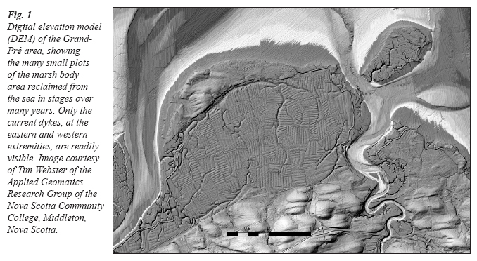
Display large image of Figure 1
6 Where does the distinctive Acadian preference for reclaiming salt marshes come from? A number of researchers have made a successful link with western France, from which the early colonists came in the middle decades of the 17th century (Cormier 1990; LeBlanc 1988: 39-45; Leonard 1991: 31-59). That makes sense because in western France—in areas like the marais Poitevin—there was an expertise in the use of wetlands going back many centuries. People there did not pursue the exact kind of reclamation the Acadians did, and the settings were drastically different in terms of the height of ocean tides encountered, but the basic skill set and even some of the specific tools the Acadians used already existed in western France prior to the settlement of Atlantic Canada (Bleakney 2004: 35-38, 182; Leonard 1991: 40). That explanation, however, is not the end of the story. Other peoples, in different parts of the world, also erected dykes and practised agriculture by reclaiming marshland. Though there are no direct linkages between those peoples and the Acadians, it is nonetheless important to realize that there was a broad context for the approach the latter adopted in Acadie/Nova Scotia. This international comparative context will be examined later in the paper. First, the matter of community control is considered.
Community Control
7 American geographer Karl Butzer (2002) and Canadian historian Brenda Dunn (2004) have both concluded that in 1650 Charles Menou d’Aulnay was the “catalyst” for the introduction of French dyking techniques at Port Royal, off the Bay of Fundy. If that is so, unnamed and ordinary Acadians took it from there over the next century, for one of the characteristics of Acadian marshland reclamation is that it was, with the exceptions of d’Aulnay around 1650 and Abbé LeLoutre in the Chignecto region around 1750, not led by charismatic figures or any kind of hierarchical organization. That is, Acadians at the grassroots village level decided which marsh areas they were going to dyke and when and how they were going to carry out those projects. Typically, they chose to live where they did precisely because there were one or more marshes nearby. As many villages were composed of a single extended family, it meant that most reclamation projects were implemented and managed at the family level. Collectively, Acadian families reclaimed a large quantity of wetlands (the 5,261 hectares mentioned above), but that total was achieved over the course of a century by means of many small, locally controlled projects.3
8 At Grand-Pré, however, the marsh was too vast for it to be reclaimed by a single family. Indeed, the name they gave the place—grand pré or large meadow—speaks for itself. When the first Acadians settled there in the 1680s, what is today dry farmland called the Grand Pre Marsh Body, was then covered with sea water twice daily. Each time the tides pulled back between the two pieces of firm land, the mainland and Long Island, then two kilometres offshore, there was a meadow of 1,200 hectares of marsh grasses with small brooks and streams. Biologist and dykeland historian Sherman Bleakney has concluded that the Acadians who came to live at Grand-Pré carried out that major reclamation in a series of manageable sub-projects. According to Bleakney’s analysis, the farming families at Grand-Pré took seventy years, in likely twelve distinct phases, to convert the large salt marsh into arable land. Some reclamation phases were as small as forty-two hectares; the largest was 138 hectares (Bleakney 2004: 71-94).4 How exactly the villagers came to the arrangements they did regarding the work that needed to be carried out, will likely never be known. Yet those construction details, and later maintenance arrangements, were sorted out at the community level, without any outside or hierarchical imposition.
Fig. 2 Depiction of Acadian dyke construction at Grand-Pré by artist Lewis Parker. Courtesy of Parks Canada, Atlantic Service Centre, Halifax.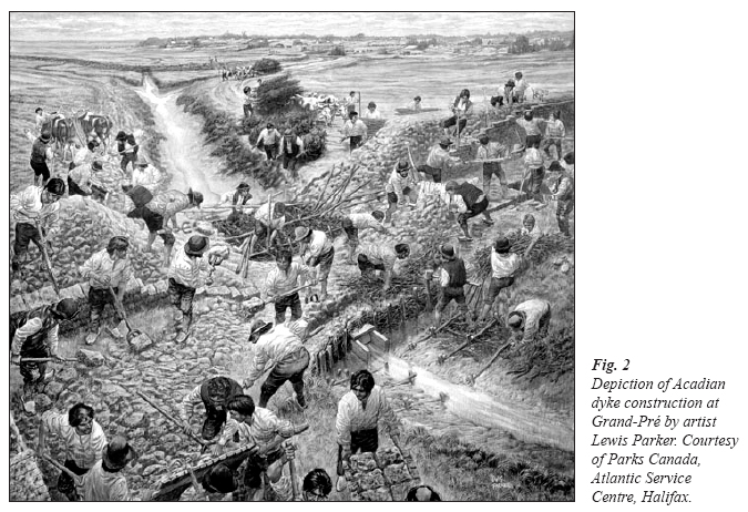
Display large image of Figure 2
9 Bleakney’s analysis of dyke construction provides insights into how many people were needed to build or repair dykes. Obviously, those requirements were different for a tiny “pocket” marsh in the vicinity of Port Royal/Annapolis Royal than they were for the vast meadow at Grand-Pré. Tidal amplitudes also varied widely around the Bay of Fundy and the Minas Basin, which equally affected the height and base of the dykes that were required (Bleakney 2004: 11-19).5 Bleakney concludes that pre-industrial dyke era construction was not something that occupied families or villages for weeks or months every summer. Rather, he postulates that under ideal conditions a single six-man unit could have built sixteen linear feet of dyke per day, or 320 linear feet in twenty working days. If there were three or five times that number of six-man units then the output would be multiplied by that factor (Bleakney 2004: 60-61). Regarding Grand-Pré, the largest of all the pre-Deportation dyked areas, Bleakney writes: “Sixty men would take only forty-five days, spread over two months of tidal cycles, to achieve the annual average of 7,710 feet of new wall construction” (91).
Fig. 3 Acadian sluice (or dalle) excavated near the Melanson Settlement National Historic Site. Photo by Brenda Dunn.
Display large image of Figure 3
Display large image of Figure 4
10 Before such specifics were known about how many people were involved in dyke construction and maintenance, some historians, notably Gabriel Bertrand, emphasized how reclamation projects played an important part in fostering a sense of solidarity among Acadians (Bertrand 1993). It was a plausible interpretation, for dyke projects were the undeniable basis of Acadian agriculture and they definitely served overall community interests. It is a persuasive interpretation, though it is likely to lose some of its influence the more we learn about the relatively small scale of most Acadian reclamations: how most marshes were small, and dyked and desalinated separately from each other by individual families, rather than by large communities. An exception is the vast Grand-Pré marsh, which does at this point appear to have been community-based and completely in line with Bertrand’s argument.
11 Bleakney’s calculations and analysis render the Acadians’ extensive dyking—dozens of separate projects, most quite small with the exception of Grand-Pré—as a kind of vernacular engineering, an approach to agriculture that required considerable ingenuity and labour. The two to three-year waiting period that marsh reclamation required for the salt to leach out was well worth the wait. The unrivalled fertility of the desalinated marshes, not to mention the absence of rocks or stumps, allowed the Acadians to produce more abundant crops than they ever could have by clearing the uplands of Acadie/Nova Scotia.
12 The kind of family, village and/or broader community control over land reclamations that one finds in the Acadian experience also existed in some parts of Europe. However, according to Karl Butzer (2002), beginning in the late 1500s in the Low Countries and in the mid-1600s in western France, community control over land reclamation of marshy areas gradually disappeared. The transition occurred because dyke projects grew steadily larger, too large to be funded and controlled at the local level. The outside forces varied from case to case, but the usual suspects were wealthy landowners, monasteries and the state. Butzer concludes that the “top-down” approach inevitably “reduced the autonomy of local communities and met determined social resistance” (464) from those local residents. It is generally accepted that such large agricultural projects, like those involving large-scale irrigation, either require or lead to “centralized water control and social hierarchy” (Carney 2001: 65). Thus, with a massive land reclamation project such as occurred on the Po Plain in 16th-century Italy, it was not local people but consortiums and investors that undertook to build canals and other projects to reclaim marshy terrain around Padua, Verona and Rovigo (Ciriacono 2002: 55-60). Clearly, the 70,000 hectares of drained and irrigated land on the Po Plain was beyond what small landowners might have accomplished on their own.
13 The evidence from 17th- and 18th-century Europe suggests, perhaps, that the Acadian experience was an exception to the theory of a necessary “social hierarchy” to carry out large land reclamations. For the Acadian projects, again with the possible exception of those led by d’Aulnay and LeLoutre, were community generated and controlled. Furthermore, there is no evidence of any resistance from individual Acadians to any of the projects undertaken in their districts. Conceivably, there were Acadians who resented and maybe even resisted toiling for LeLoutre on his grand dying project in the Chignecto isthmus, but with a lack of primary sources that remains a subject for speculation.
14 It is tempting, therefore, to make a case for Acadian “exceptionalism”: that unlike people in the Low Countries, France, England and Italy, Acadians were able to achieve their reclamation projects without the need for outside hierarchical control or compulsion. There may be a different interpretation, however, of the phenomenon of Acadian community control over their dyking projects. I offer that alternative explanation after considering a few of the non-Acadian land reclamations around the world. The next few examples provide the beginning of a basis for a fair comparison.
The International Context
15 Researchers have already established the links between Acadian dyking practices and previous wetlands approaches and techniques in France. It is helpful to look at an even broader context, for there were more than a few peoples who undertook land reclamation for agriculture. Our starting point is a comment by Karl Butzer:By European standards, Acadian technology was state-of-the-art in the early 1600s, not a rustic or backward practice, as it was seen by uninformed French and British observers. It ranks among the very first introductions of European intensified agriculture to North America. (2002: 464)Butzer goes on to state in the endnote for that comment that “Acadian practices were mainstream by European standards” (468).
16 That is a point not often communicated by those writing on Acadian dyking, where the impression conveyed is often that the Acadian achievements were highly unusual; that is, dyking and land reclamation were rare in colonial North America. Rare, of course, does not mean unique, and North America is not the world.
Estuarine Environments in General
17 People have hunted, fished and harvested plants in wetlands—both salt water and fresh —for as long as can be remembered. Attempts to alter estuarine ecosystems permanently are a more recent development in human history, dating back only a few thousand years, at which point human beings could see themselves as separate from, and dominant over, nature.
18 It is unknown when or where people erected the first dykes to reclaim wetlands to make them arable and/or habitable. Butzer places the phenomenon in China at around the 11th century, in Europe in medieval times and in Africa by the 15th century (452-70). The phenomenon may have been older in Africa, but there is an absence of documentary sources. Though lakes in Italy are not estuarine environments, it is nonetheless worth mentioning that in Roman times different emperors set out to drain lakes in Italy by means of digging channels (emissaria) to create additional agricultural land. To state the obvious, those projects were not community-based initiatives. Claudius apparently had 30,000 men work for eleven years to drain Lake Fucine,6 though the lake was not completely drained until the 19th century.
19 The Roman desire to create agricultural land where nature had given them a lake or a marsh surfaced during their period of occupation of Britain. Roman engineers sought to figure out how to drain the fens, the vast marshes that occupied the southeastern quarter of Lincolnshire, the north half of Cambridgeshire and portions of the counties of Norfolk, Suffolk, Huntingdon and Northampton. Alas, the Romans did not have much success in that regard. It would be much later, beginning between 1600 and 1663, and then continuing again in the 18th and 19th centuries, that more than 280,000 hectares of tidal and overflowed peaty lands in western England were reclaimed (Darby 1968).
Reclamation Projects in the Netherlands
20 The first dykes constructed in the Netherlands probably date from around 1000 CE, but it was not until the 12th and 13th centuries that the Dutch began to undertake projects to create polders, or reclaimed land (Vervolet 2002). Today, two-thirds of the Netherlands consists of land taken from the sea.
21 The most renowned of the many Dutch reclamation projects is the Beemster Polder, which was inscribed as a World Heritage Site in 1999. The Beemster Polder dates from the early 17th century and is the oldest area of reclaimed land in the Netherlands. Its well-ordered landscape of fields, roads, canals, dykes and settlements—laid out in accordance with classical and Renaissance planning principles—are preserved intact.7 Over a period of only six years, from 1607 to 1612, Dutch engineers used a network of forty-two windmills to pump water from behind the dykes they built, reclaiming slightly more than 7,000 hectares from the sea.
22 Though the Beemster Polder itself is larger and older than the total amount of wetlands reclaimed by Acadians over about a century, both testify to the ingenuity of humankind when it comes to overcoming natural obstacles and conditions to create arable land. A significant difference between Acadian dyking projects and the Beemster Polder is that the former were typically undertaken by a relatively small number of local landowners acting on their own initiative, whereas the latter was a massive project with outside financing and control.8
Dyking for Rice Cultivation in Africa
23 When the first Portuguese explorers reached West Africa (today’s Senegal, The Gambia, Guinea-Bissau, Guinea and Sierra Leone) in the 15th century, they observed extensive use of dykes for rice cultivation. As the Portuguese and later Europeans learned, various African nations had different ways to grow rice, depending on the situation in which they lived. No European or North American realized until the 20th century that there existed within Africa at least one type of rice (Oryza glaberrima) that was unknown in Asia, and which appears to have been cultivated by people living in Africa several thousand years ago.9
24 Women often played a leading role in the planting and harvesting of rice in West Africa. In some locations, the cultivators planted rice in upland settings where rainfall was the sole water source; in other areas, they grew rice in inland, freshwater swamps. A third approach involved growing rice in mangrove swamps along the coast, where the cultivators had to deal with salt water and tides. It is that last form of agricultural production that is somewhat comparable to what the Acadians achieved in Acadie/Nova Scotia.
25 The peoples who lived in the estuaries between the Gambia and Geba Rivers cultivated rice in irrigated perimeters of coastal mangrove swamps. To protect their rice-growing areas from marine tides they constructed earthen embankments for kilometres along the coast, then built lower dykes within the enclosed areas for separate rice-growing paddies. In 1594, a Luso-African observer wrote: “the residents were growing their crops on riverain deposits, and by a system of dikes had harnessed the tides to their own advantage.” As in Acadia, there were sluice gates and canals and considerable landscape manipulation, as well as a requirement for community-wide support to maintain the chosen agricultural system. Also similar to the Acadian experience, it took two to three years for the salt to leach out of the soil before it could be cultivated.
26 Despite those similarities, it is important to recall that the marine tides that confronted West African rice cultivators along the coast south of the Gambia River typically reach six metres, only one-third the height of those found in some areas of Acadian dyking. Moreover, the West African focus was to create ponds within which one could grow rice, where the Acadians reclaimed marshes permanently from the sea for a wide range of grains and vegetables.
Dyking for Rice Cultivation in South Carolina and Georgia
27 When Africans from the rice-growing parts of West Africa were enslaved and transported to the Americas they took their knowledge of the wetland cultivation of rice to their new settings. Two destinations where conditions were appropriate for that approach to agriculture were South Carolina and Georgia. Enslaved Africans in those coastal locations introduced rice cultivation using techniques their ancestors had long mastered in their homelands. This involved the construction and use of embankments, dykes, sluice gates and canals. This production began in the 17th century and continued until slavery was abolished in the United States in the 1860s. Judith Carney estimates that around 1860, there were approximately 125,000 slaves growing rice along about 40,000 hectares of coastal plain in South Carolina and Georgia (Carney 1996).
28 As with African rice cultivation, these projects differed in several important ways from Acadian approaches. The most obvious difference relates to the idea of community control, which was completely lacking in the context of slavery. As for the similarity in techniques—raised earth embankments, sluice gates and canals—the two systems of agricultural production were quite different. Where those responsible for rice cultivation in the American coastal zone needed to control the flooding of fields so that they could grow a single crop—rice—the Acadians completely reclaimed their marshlands to create dry land upon which they grew a range of crops. Another difference, noted already, is the difference in tidal amplitude between the two regions. The tides in some of the reclaimed parts of Acadia/Nova Scotia are the highest in the world.
Reclamation Projects along the Delaware River
29 European colonists along the Delaware River adopted an approach to reclaiming marshland from the sea for agricultural purpose that was similar to that of the Acadians.
30 The area in question was a Swedish colony that became a Dutch colony before passing under British control. In the colony of New Castle (in today’s Delaware) farmers started to erect dykes for land reclamation for agricultural purposes around 1675. That was a generation after the first Acadian reclamations began in the area of Port Royal.
31 Unlike the typical Acadian approach, the Dutch farmers along the Delaware Bay did not initiate the project themselves. The initial impetus for reclamation came from Governor Edmund Andros and the Dutch magistrates of New Castle. They “ordered all the male inhabitants of the district of New Castle to construct a dike 10’ wide at the bottom, 5’ high and 3’ wide at the top with several strong sluices” (Sebold 1992: 4). Thus, at the start at least, this was not an example of a community-initiated reclamation project.
32 The work along the Delaware River was carried out under the direction of a few Dutch individuals who knew how to reclaim land from the sea. The years that followed saw more projects and a growing appreciation for the fertility of the reclaimed marshland. In the late 17th century, a Dutchman travelling throughout New York and New Jersey commented that more grain was being gathered from the dyked areas than on the cleared upland. Similarly, others commented that the salt hay grown on the marshes made for healthier cattle than the hay from the upland (Cohen 1992: 71-72).
33 When the Swedish botanist Peter Kalm travelled through the region in the mid-18th century he made the following comment:Dykes were made along all rivers here to confine their water; therefore when the tide was highest, the water in the rivers was much higher than the meadows; in the dykes were gates through which the water can be drawn from, or led into the meadows; they [were] sometimes placed on the outward side of the wall, so that the water in the meadows forced it open, but the river water shut it. (Kalm [1771] in Hatvany 2002: 75)Eventually, landowners along the Delaware River would reclaim more than 26,000 hectares of coastal marshlands.10
Use of Wetlands in Other Areas of French Colonization
34 Within the broad context of French colonization in North America, the Acadian custom of reclaiming salt marshes to convert them to farmland was apparently unique. Other French colonists, notably in the Kamouraska region along the St. Lawrence River, exploited their local salt marshes for fish, wild fowl, salt hay and pasture land. In 1725, the output from the Kamouraska salt marshes represented twenty-five per cent of the local farmers’ agricultural production. Nonetheless, the farmers of Kamouraska did not undertake extensive dyking and reclamation the way Acadians did (Hatvany 2002: 74).
Conclusion
35 There are two aspects that set the Acadian dyking achievements apart from most of the other undertakings discussed above. The first, and most straight forward, is the height of the tidal amplitudes with which some Acadians had to deal—in particular, those who reclaimed the Grand-Pré marsh. Here, in the narrowing confines of the Minas Basin, the tides are the highest in the world (up to 15.3 metres). Elsewhere along the Bay of Fundy the twice-daily rise in sea water was as high as, or higher, than in other places discussed in this essay. Without exaggeration, one can conclude that the Acadians showed a remarkable degree of vernacular engineering ingenuity in accomplishing what they did.
36 The second distinctive aspect of Acadian dyking—that it was generally controlled from within the community and not by outside forces—deserves a longer explanation. I observed earlier that the Acadian experience might call into question the school of thought that large agricultural projects require or lead to “centralized water control and social hierarchy” (Carney 2001: 65). There are two key elements to that hypothesis. One relates to the question of size or scale—how large does something have to be in order to be considered large—while the other requires a context in which terms like “centralized” and “social hierarchy” make sense. My analysis of how those two elements fit together leads me to conclude that the Acadian dyking achievement was remarkable, but not an example that runs counter to the accepted school of thought about the need for a hierarchy to undertake large reclamation projects.
37 To start with the size issue, the Acadian reclamations during the pre-Deportation era were impressive, especially taking the tidal amplitude into account. They were not, however, particularly large in global terms. Sherman Bleakney’s interpretation of the largest of all those reclamations, the 1,200-hectare “marsh body” at Grand-Pré, as that man-made giant artifact is described today, is that the Acadians carried out that major reclamation in a series of manageable sub-projects. According to Bleakney’s analysis, the Acadians converted the salt marshes at Grand-Pré into arable farmland over the span of seventy years, in likely twelve distinct phases. Some phases were as small as forty-two hectares; the largest was 138 hectares (2004: 71-94).11 Such figures do not compare with the much larger reclamations discussed above, which were indeed undertaken with outside funding and control. Given the relatively small scale of the Acadian dyking projects, it is not surprising that local villagers carried out the work themselves, without outside funding or intervention.
38 As for the matter of terms like “centralized” and “hierarchy,” I suggest they are not fitting for pre-Deportation Acadian society. Though the French called the region Acadie and the British knew it as Nova Scotia, neither imperial power exercised much effective control over the region on a consistent basis. Most of Acadie/Nova Scotia was part of the traditional territory of the Mi’kmaq—who regarded the area as Mi’kma’ki. The localities where the Acadians mostly settled—scattered, sprawling and generally disconnected villages along the Bay of Fundy and the Minas Basin—were only infrequently subject to formal or institutionalized outside authorities. Unlike many, or most, European agricultural areas, Acadian villages had to cope with relatively few hierarchical measures or controls, prior to the 1750s. That assessment is not an idealization of their experience, but a conclusion many have drawn, including contemporary outsiders who regularly found fault with the Acadians for their independence.12
39 To be more specific, historian Jacques Vanderlinden calculates that there was an effective French administration of the imprecisely defined Acadian region for only ten of the first hundred years of permanent French colonization (2003: 157).13 When the British took over the colony in 1710-1713, Acadians demonstrated their reluctance to be governed by the new authorities by migrating away from the Port Royal/Annapolis Royal zone to the Chignecto, Les Mines/Pisiquid and Cobequid districts.14 Historian Naomi Griffiths has written extensively about Acadian history. One point she made early in her research was that they were a people “united by blood ties, common beliefs and common aims for the group as a whole [who] flourished despite the lack of a uniform and stable direction from a financially influential headquarters” (Griffiths 1973: 18). It may be argued that the absence of any kind of well-established “headquarters”—or what today we would call state control—meant that for long periods there was no one but the Acadians themselves to determine where they were to settle, farm or build dykes. In agriculture, as in fishing, they were a largely self-governing people. (Religion was a different matter, for there usually were priests and missionaries serving the different communities, and their world was constrained by a well-known hierarchy, albeit one relatively far away in Quebec or France (Leger 1997). Trade was also sometimes subject to external control, though not as effectively as the remote French and/or British administrations would have liked.)
40 For many years, the Acadians were able to market the grain, produce and livestock grown on the reclaimed marshland to whoever would purchase it, regardless of imperial affiliation. The tragedy for this long independent and largely ungoverned people was that following the establishment of a major British base at Halifax in 1749—and then additional British military posts in or close to Acadian areas—a new administration slowly but surely began to flex its muscles in an attempt to bring the Acadians under state control. The result, ultimately, was a wholesale deportation between 1755 and 1762 that resulted in all Acadians, numbering slightly more than 14,000 men, women and children, being uprooted (White 2005: 21-56). Soldiers from New England and Great Britain removed most; the remainder fled to other regions before they were apprehended.
41 Clearly, it is neither surprising nor exceptional that the Acadians envisioned and controlled their land reclamations. The scale of the projects they undertook at any point in time was modest when compared to some of the massive reclamations pursued in the Low Countries, England and Italy. Moreover, there existed no external authorities or funding institutions anywhere in the region that had a desire or inclination to become involved in land reclamation. Dyking was either carried out locally, on a scale a given family or village could handle, or nature and its marshes were left as they were.
42 The removal of all Acadians from Nova Scotia meant that the extensive dyked marshlands they toiled to create over the course of a century would fall to others to maintain—initially Planters, or settlers, from New England. The Planters did exactly that, and the marshlands they took over, and later expanded, remain valuable agricultural resources to this day. Interestingly, although there is now provincial legislation in Nova Scotia safeguarding the dyked areas for agricultural use and a government department with responsibility for the maintenance of the dykes, those areas known as “marsh bodies” remain privately owned by farmers. They exercise a level of local community control over the access and use of the reclaimed land that harkens back to the original Acadian era.15
References
Bertrand, Gabriel. 1993. La culture des marais endigués et le développement de la solidarité militante en Acadie entre 1710 et 1755. Les Cahiers de la Société historique acadienne 24 (4): 238-49.
Bleakney, J. Sherman. 2004. Sods, Soil and Spades: The Acadians at Grand Pré and Their Dykeland Legacy. Montreal and Kingston: McGill-Queens University Press.
Butzer, Karl W. 2002. French Wetland Agriculture in Atlantic Canada and Its European Roots: Different Avenues to Historical Diffusion. Annals of the Association of American Geographers 92 (3): 451-470.
Carney, Judith A. 1996. Landscapes of Technology Transfer: Rice Cultivation and African Continuities. Technology and Culture 37 (1): 5-35.
———. 2001. Black Rice: The African Origins of Rice Cultivation in the Americas. Cambridge, MA: Harvard University Press.
Chevrier, Cécile. 1978. Les Défricheurs D’eau Le Village Historique Acadien En textes et en images. Ottawa : Village Historique Acadien, publication 1.
Ciriacono, Salvatore. 2002. Les marais italiens dans le contexte européen du XVIe au XICe siècle. Dans Aux rives l’incertain : Histoire et représentations des marais occidentaux du Moyen Age à nos jours, dirs. Philippe Bata, Anne Péan, Dominique Guillement, Jacques Péret, et Jean-Roger Soubiran, 55-60. Paris: Somogy éditions.
Cohen, David Steven. 1992. The Dutch-American Farm. New York: New York University Press.
Cormier,Yves. 1990. Les aboiteaux en Acadie: Hier et aujourd’hui. Moncton: Chaire d’Études acadiennes.
Daigle, Jean. 1994. 1650-1686: ‘Un pays qui n’est pas fait.’ In The Atlantic Region to Confederation: A History, eds. Phillip A. Buckner and John G. Reid, 66-77. Toronto: University of Toronto Press.
Darby, H. C. 1968. The Draining of the Fens. Cambridge: Cambridge University Press.
Dunn, Brenda. 2004. A History of Port-Royal/Annapolis Royal, 1605-1800. Halifax: Nimbus Publishing.
Faragher, John Mack. 2005. A Great and Noble Scheme: The Tragic Story of the Expulsion of the French Acadians from Their American Homeland. New York: W. W. Norton.
Griffiths, Naomi. 1973. The Acadians: Creation of a People. Toronto: McGraw-Hill Ryerson.
Hatvany, Matthew. 2002. L’origine de l’aboiteau acadienne : pour une approche environmentale. Dans Aux rives de l’incertain : Histoire et représentations des marais occidentaux du Moyen Age à nos jours, dirs. Philippe Bata, Anne Péan, Dominique Guillement, Jacques Péret, et Jean-Roger Soubiran, 71-77. Paris: Somogy éditions.
Hilliard, Sam B. 1978. Antebellum tidewater rice culture in South Carolina and Georgia. In European Settlement and Development in North America ed. J.R. Gibson, 91-115. Toronto: University of Toronto Press.
Johnston. A. J. B. 2004a. Imagining Paradise: The Visual Depiction of Pre-Deportation Acadia, 1850-2000. Journal of Canadian Studies 38 (2): 105-28.
———. 2004b. The Call of the Archetype and the Challenge of Acadian History. French Colonial History 5: 63-92.
———. 2005. French Attitudes Toward the Acadians, ca. 1680-1756. In Du Grand Dérangement à la Déportation : nouvelles perspectives historiques, ed. Ronnie-Gillis LeBlanc, 131-66. Moncton: Chaire d’études acadiennes, Université de Moncton.
Kalm, Peter. 1771. Travels into North America: Containing its Natural History, and A Circumstantial Account of its Plantations and Agriculturre in General, With the Civil, Ecclesiastical and Commercial State of the Country. London: T. Lowndes.
LeBlanc, Ronnie-Gilles. 1988. Documents acadiens sur les aboiteaux. Les Cahiers de la Société historique acadienne 19 (1-2): 39-45.
LeBlanc, Ronnie-Gilles, ed. 2005. Du Grand Dérangement à la Déportation, nouvelles perspectives historiques. Moncton: Chaire d’études acadiennes, Université de Moncton.
Leger, Maurice A. 1997. Les missionaires de l’ancienne Acadie (1604-1755). Les Cahiers de la Société historique acadienne 28 (2-3): 63-97.
Leonard, Kevin. 1991. The Origin and Dispersal of Dykeland Technology. Les Cahiers de la Société historique acadienne 22 (1): 31-59.
Rouet, Damien. 1998. L’Acadie, du comptoir à la colonie. Migration et colonisation du Bassin des Mines 1680-1714. Les Cahiers de la Société historique acadienne 29 (1-2): 34-56.
Sebold, >Kimberly R. 1992. From Marsh to Farm: The Landscape Transformation of Coastal New Jersey. Washington: United States Department of the Interior, National Parks Service.
Vanderlinden, Jacques. 2003. Regardes sur l’historie du doit en Acadie dix ans après. Les Cahiers de la Société historique acadienne 34 (4): 152-64.
Vervolet, Jelier. 2002. Le défrichement et l’exploitation des basses terres aux Pays-Bas ; un bref aperçu, dans Aux rives de l’incertain: Histoire et représentations des marais occidentaux du Moyen Age à nos jours, dirs. Philippe Bata, Anne Péan, Dominique Guillement, Jacques Péret et Jean-Roger Soubiran, 39-46. Paris: Somogy éditions.
White, Stephen. 2005. The True Number of Acadians. In Du Grand Dérangement à la Déportation : nouvelles perspectives historiques, ed. Ronnie-Gillis LeBlanc, 21-56. Moncton: Chaire d’études acadiennes, Université de Moncton.
Notes