Vol. 16, No. 2 July 2005
Glen Murphy
Michael G. Wing
Oregon State University
Oregon, USA
The authors are, respectively, Professor and Assistant Professor, Forest Engineering Department, Oregon State University.
ABSTRACT
Road sediment yields reaching streams over a twenty year period were modeled under two scenarios for a 4900 ha forest in the foothills of the Oregon Coast Range. In the "clustered" scenario all forest harvesting activity took place in the northern half of the forest. In the "dispersed" scenario the same level of forest harvesting activity was allocated to the full forest estate. Three spatial modeling packages were used: SPECTRUM was used to schedule the harvest settings over a 150 year period, NETWORK 2000 was used to determine which roads would be used during the first 20 years of harvest and how many truck loads would be transported over them, and SEDMODL2 was used to determine the road sediment yields likely to reach a stream. Concentrating the forest harvesting activity on half of the forest estate resulted in a 36% reduction in total road sediment yields when compared with dispersed forest harvesting activity. Fewer roads would generate sediment under the "clustered" scenario but traffic intensities on these roads would be greater, partially negating the sediment yield savings.
Keywords: landscape level analysis, intensive management, SEDMODL2, Oregon, United States.
INTRODUCTION
All streams have naturally occurring background sediment levels that are a function of surrounding topography, soils, vegetative cover, and precipitation. Sediment can enter streams through a variety of naturally occurring processes including soil erosion, soil mass movements, and stream channel attrition. These processes vary spatially and may occur infrequently or more continually through time.
The delivery of fine sediment into streams can adversely affect aquatic habitat complexity by reducing the number of pools, and the depth and volume of pools [3]. Although the impacts of fine sediment on fish populations are dependent on the volume, composition, and timing of delivery to streams, impacts are generally negative when sediment levels are consistently elevated [13]. Impacts may include increased mortality rates and decreased growth rates in fish.
Within forested watersheds, roads can act as a significant source of sediment. In terms of the potential contributions of sediment from forest management activities, roads have been identified as the primary contributor to stream sediment levels in the western United States [11, 15]. Sediment can be generated as a result of road construction, failure, and vehicular use. Studies have shown that recently constructed roads may experience ten times more surface erosion during the year following construction than in following years [9]. Road construction activities typically remove vegetative cover from the road surface and surrounding areas including the cutslope, fillslope, tread, and drainage ditches. The collection of these areas is often referred to as the road prism. The removal of vegetation within the road prism leads to erosion processes and creates a sediment source. Over time, vegetation will recover in the cutslope and fillslope areas and erosion potential is decreased. However, the tread and ditch will likely continue to produce sediment as long as road use continues. The actual delivery of sediment will depend on a road's nearness and hydrologic connectivity to surrounding streams. The majority of fine sediment delivered to streams from erosion processes is transported in precipitation runoff and is a process that occurs persistently. In comparison, although road-related landslides have the potential to deliver larger volumes of sediment, these and other mass-movement events are more episodic in frequency. The amount of heavy vehicle traffic is perhaps the single greatest factor affecting generation of sediment from road surfaces [16, 21] and harvesting activity is the major determinant of heavy vehicle road usage in a forest.
Forests, and forest harvesting activity, can be managed in many ways. Two possible approaches for managing harvesting activity are (1) the dispersed model where harvesting can be undertaken on almost any piece of land at some point in time, and (2) the segregated or clustered model where timber production and harvesting are clustered on some portions of the landscape and excluded, in perpetuity, from other portions that have different management objectives (e.g. wilderness). Both approaches are advocated and practiced in various parts of the world.
Forest management activities affect a landscape over a broad range of spatial and temporal scales. There are limits in terms of costs, feasibility, and experimental replication in undertaking research on landscape level impacts. Spatial and temporal models have, therefore, become a necessity for researching landscape level management impacts [10]. Landscape level models are now used for developing an understanding of management activities on a wide range of issues; e.g., fire risk [7, 19], disease spread [20], and wildlife habitat [18, 5]. These models themselves are often complex systems, made up of one or more linked models. For example, Canadian researchers at the Pacific Forestry Centre are working on a mountain pine beetle spread and impact model that would link many sub-models including among others models on fire behaviour and growth, prescribed fire assessment, fire effects on stand composition and succession, fuel dynamics, beetle/host dynamics, beetle predator impacts, climate and landscape planning [14].
In this paper we describe the modeled effects of two approaches to forest management - dispersed and clustered harvesting activity - on road sediment yields reaching streams for a single forest in the foothills of the Oregon Coast Range. We also identify the need for further case studies on sediment yield impacts at the landscape level as opposed to the single-stream or single-road level.
METHODS
Forest Description
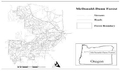
McDonald-Dunn Forest covers approximately 5540 ha (~4930 ha of which is forested) and is located on the eastern foothills of the Oregon Coast Range. The forest is managed by the College of Forestry at Oregon State University for research and teaching purposes. McDonald-Dunn Forest was selected since it is large enough to allow a landscape level analysis and has good GIS coverage of stand, road, streams and soils data.
Vegetation in McDonald-Dunn Forest is typical of the Oregon Coast Range, with Douglas-fir (Pseudotsuga menziesii) being abundant and Oregon white oak (Quercus garryana) also present. In addition, Red Alder (Alnus rubra) can be found within riparian corridors. The forest contains varying terrain and elevation ranges from about 37 to 646 m above sea level. Average precipitation in McDonald-Dunn Forest is approximately 172 cm per year. Soils in the McDonald-Dunn Forest are predominantly silty clay loams. The geology of the forest consists of layers of interweaved basaltic siltstone and sandstone mix, basaltic tuff, and other basaltic conglomerates.
The McDonald-Dunn Forest has a relatively dense road network of 192 km for a road density of approximately 3.9 km of road per km2 of forest. Roads on the forest were assigned to one of three classifications based on road width; spur roads (~4.5 m), secondary roads (~5.5 m) and primary roads (~7.5 m). Classifications were not field verified. All road surfaces were assumed to be graveled. Roads and streams within the forest boundary are shown in Figure 1.
Figure 1. Road and stream locations within McDonald-Dunn Forest.
Scenarios Modeled
Four scenarios were evaluated in this study. In the "Dispersed" scenario harvesting activity was dispersed over the total forest estate. In the "Clustered" scenario harvesting activity was confined to the northern half of the forest and we assumed that no roads were located in the southern half of the forest. The "Clustered" scenario would be equivalent to a situation where part of the forest estate had no "legacy" roads in it and forest plans precluded both roading and harvesting activity in this area. Two variants of the "Clustered" scenario were also modeled. The "Clustered + Fire Access" scenario included the provision of a fire access road in the southern half of the forest. The "Clustered + Fire Access + Abandoned Roads" scenario assumed that there were legacy roads in the southern half of the forest but, other than a fire access road, all of these would be abandoned since harvesting would only take place on the northern half of the forest. It should be noted at this point that the forest owners are not considering any of the scenarios described in this paper and that these were evaluated solely as a research exercise.
Model Descriptions
We applied three spatial models to address the study objectives and obtained GIS layers for the forest, representing roads, streams, stand unit boundaries, and elevation.
Spectrum, an optimization program that was designed for forest planning [22], was used to develop harvest schedules for the McDonald-Dunn Forest based on stand data and relevant growth models. Optimization goals were to secure an even flow of timber volume and revenue through a 150-year horizon using harvest periods that were each 10-years long. Targeting an even flow of timber volume over such a long period ensured that (1) simulation of the impacts would not be related to a period of especially high or low harvesting activity, and (2) both spatial and temporal effects of management were taken into account.
Volumes harvested in each period were the same in all four scenarios. The locations of stand units selected for harvest were not subject to adjacency constraints explicitly in the Spectrum analyses; harvests could occur in any unit regardless of whether neighboring units were harvested. Harvest units within each 10-year period were then manually allocated to a harvest year. Manual allocation was based on maintaining an even flow of annual harvest volume (+/-10%) and spatially or temporally separating harvest units to approximate meeting adjacency constraints.
Network 2000 is a software program that is designed to solve fixed and variable cost transportation problems [2]. Users can input a GIS-based road network file that describes road segment connectivity and apply one of several problem-solving techniques to minimize transportation "costs" including the total length of road utilized by vehicles. Harvest volumes obtained from Spectrum were converted to standard logging truck loads (~27 tonne payload). We used Network 2000 to determine (1) the optimal routing of logging trucks from each harvest unit location to appropriate markets within the Willamette Basin, and (2) the number of loads transported within the McDonald-Dunn Forest boundaries over each road segment along the optimal routes. Optimality was based on log truck fuel consumption, an indicator of transport costs.
SEDMODL2 is a GIS-based road erosion and delivery model [25]. SEDMODL2 was created to locate road segments that have a high likelihood of transporting sediment to adjacent streams and to provide estimates of road erosion and delivery quantities [12].
The model operates within a watershed context and integrates GIS elevation surfaces with road and stream information layers to produce road erosion estimates. Sediment volume estimates are based on road erosion and traffic factors drawn from the Washington Department of Natural Resources Standard Method for Conducting Watershed Analysis [24]. SEDMODL2 calculates a number of parameters including background sediment in the watershed, sediment volumes for individual road segments, the intersection points of roads and streams, and estimates of sediment delivery of road sediment to streams. Other data layers, including culvert locations, precipitation, geology, and soil, can also be integrated into SEDMODL2 calculations; data layers for precipitation and soil are made available with the SEDMODL2 software for Oregon, Washington, and Idaho. Using SEDMODL2 layers, the forest geology was described as basalt and precipitation averaged 149 cm.
One of the primary functions of SEDMODL2 is to identify roads that are likely to deliver sediment to streams. SEDMODL2 uses GIS layers to divide all road segments into one of four delivery potential categories. Road segments that intersect streams are assigned to a direct deliver category and it is assumed that the probability of sediment reaching a stream is 100%. Roads that run parallel to streams and are within 30 m slope distance, or within 30 to 60 m slope distance, from streams are classified as indirectly delivering sediment and have probabilities of 35% and 10% respectively for sediment reaching the stream. All other roads are assumed to not deliver sediment to streams and are not involved in further SEDMODL2 calculations. These delivery percentages are for a worst-case scenario; the use of best management practices, such as settling ponds and silt fences, can reduce sediment yields by 25 to 85% [4].
Detailed technical documentation for SEDMODL2 and descriptions of the factors effecting sediment yields are provided in [12]. Besides geologic erosion rates, precipitation, and delivery potential rates referred to above, SEDMODL2 parameters include tread surfacing factors, road width and profile factors, road slope factors, cutslope height and cover factors, and traffic intensity factors.
Some validation of SEDMODL2 and its predecessor, SEDMODL, has occurred and results indicate that it tends to over-predict the volume of sediment delivery. Wold and Dube (1998) examined six watersheds in Washington, Oregon and Idaho covering an area of approximately 130,000 ha and found that SEDMODL overestimated the sediment yields detected by field crews by between 10% and 30% [25]. In an evaluation of SEDMODL2, field crews visited three watersheds in the U.S. Pacific Northwest. In comparison to field measurements, the model over predicted by an average of 68% the total length of roads directly delivering sediment to streams [12]. A recent study of 13 eastern Washington sites showed that the Washington Road Sediment Model, which uses SEDMODL2 to predict sediment yields, provided reasonably accurate predictions; the overall estimate of sediment from the 13 sites was 1% too high, although individual estimates could be an order of magnitude out (S. Toth, pers.comm.). Probably the most relevant comparison was done by Amann (2004) in the southern portion of the study site, McDonald-Dunn Forest [1]. Actual sediment yields were compared with those predicted by WEPP: Road [23] and SEDMODL2. It was found that WEPP: Road substantially overestimated sediment production, by several orders of magnitude, while SEDMODL2 provided accurate estimates of sediment production. It was considered that SEDMODL2 would provide predictions of sediment yields in McDonald-Dunn Forest with sufficient accuracy for comparing management scenarios; any bias could be expected to be consistent between scenarios.
We used SEDMODL2 to calculate sediment delivery on a year-by-year basis for the four scenarios. We initially ran SEDMODL2 for the dispersed harvest scenario and included all areas within McDonald-Dunn Forest in our analysis. 1644 road segments were classified as potentially delivering sediment to streams; 471 of these segments directly intersected with a stream. We then confined SEDMODL2 to consider only those areas in the northern half of the forest to simulate the clustered harvest activity. The total area was 2,560 ha and the total length of roads was 109 km in the clustered area. These figures represent 52% of the total forested area and 57% of the total road length. The two variants of the clustered harvest model included 26 km of fire-access road, and the fire-access road plus 56 km of abandoned roads. Traffic intensity was classified as nil, light, moderate, or moderate-to-heavy depending on whether NETWORK 2000 indicated the road segment of interest for the year of interest had 0, 1-200, 201-600, or >600 truck loads of logs respectively transported over it. Road width was linked to traffic intensity; wider roads carried heavier traffic intensities.
RESULTS
The average annual number of truck loads of logs harvested from the forest over the 20-year period was the same for both the clustered and dispersed scenarios; namely 1033. There were small differences in both the minimum number of loads (difference = 34 loads) and maximum number of loads (difference = 95 loads) between the clustered and dispersed scenarios but these were not expected to substantially effect the results.
If harvesting activity was dispersed across the entire forest the total amount of sediment generated from roads within the forest and reaching streams would be approximately 1400 tonnes over the 20-year period (Table 1). This equated to about 0.67 tonnes per annum per hectare of road prism. Sediment yield in any given year varied between 59 and 92 tonnes (Figure 2) and was largely dependent on the truck routes selected and the amount of traffic traveling over specific roads segments. Less than one-third of the road length was expected to deliver sediment to streams.
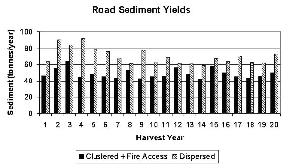
Figure 2. Annual road sediment yields predicted to reach streams under two harvesting activity scenarios: "Dispersed" where harvesting activity is dispersed over the entire forest, and "Clustered + Fire Access" where harvesting activity is clustered in the northern half of the forest and a fire access road is available in the southern half of the forest.
Table 1. Modeled road sediment yields reaching streams over a 20-year period from a 4900 ha forest in the foothills of the Oregon Coast Range.
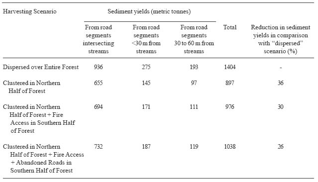
Concentrating harvesting activity in the northern half of the forest would result in less road sediment reaching streams than predicted for the dispersed scenario. The size of the reduction depended on which clustering scenario was modeled. If harvesting activity was clustered in the northern half (52% of total forest area) of the forest and there were no roads in the southern half of the forest, a 36% reduction in sediment yield would be predicted. This 36% reduction is associated with a 43% reduction in total road length when compared with the dispersed scenario. This would equate to about 0.72 tonnes of sediment reaching streams per annum per hectare of road prism. If a fire-access road was present in the southern half of the forest the reduction in sediment yield would be approximately 30% (Figure 2) and would be associated with a 29% reduction in total road length. This would equate to about 0.66 tonnes of sediment reaching streams per annum per hectare of road prism. If all existing roads, other than a fire-access road, were abandoned in the southern half of the forest, and harvesting activity was clustered in the northern half of the forest, the reduction in road sediment yield to streams would be about 26%. This would equate to about 0.54 tonnes of sediment reaching streams per annum per hectare of road prism.
As well as predicting annual sediment yield from roads that reaches streams, SEDMODL2 also predicts the background sediment yields reaching streams from soil creep and erosion of stream banks within the forest. Mass wasting is not included and may provide as much or more sediment in steep, wet watersheds. To put the road sediment yields shown in Table 1 into perspective, SEDMODL2 would predict a total background soil creep sediment yield of more than 8500 tonnes over the same 20-year period.
DISCUSSION AND CONCLUSIONS
We found that dispersing harvesting activity over a larger area could be expected to result in more sediment from roads reaching streams than would be found if harvesting activity were clustered. Concentrating harvesting activity, so that it occurred on only half of the forest estate, allowed a reduction in the amount of road sediment generated and delivered to a stream. Although 43% of the roads could be eliminated, the reduction in sediment yield would not be as great since there would be heavier traffic on the remaining road segments. A 36% reduction in sediment yield, instead of a 43% reduction would be predicted. These results do not agree with those from a modeling study undertaken in eastern Washington which found that road density reduction did not reduce predicted sediment delivery to streams [8, 17]. The authors noted that route location and logging haul traffic were important factors in determining predicted sediment yields. In another modeling exercise carried out in northern California it was found that removal of 7% of the total road network reduced predicted road sediment by 9% [6].
Other than designated roadless areas, it is likely that a fire-access road would be located in areas not allocated to timber production under the clustered harvesting management model. We found that provision of a fire-access road would decrease the size of the reduction in sediment yield.
Not all forest owners are operating in situations where large areas have not been harvested previously. If management were to decide to shift from a dispersed harvest model to a clustered harvest model under these situations it is likely that a legacy road system would already be in place. We found that abandoning legacy roads, other than a fire-access road, in areas where harvesting would not take place would still result in a reduction in total sediment yield but the reduction would only be about two-thirds that found for situations where there were no roads in non-timber production portions of the forest.
There are a number of limitations associated with this study. First, the results are based on a single case-study in the foothills of the Coast Range of Oregon; further studies under different harvesting intensities, on different terrain, and under different climatic conditions might identify other relationships between harvest activity concentration and landscape impact. Secondly, existing road descriptions were taken from maps and were not field verified. Thirdly, the roads were assumed to be in good locations; other authors have noted that a reduction in sediment yields reaching streams could be obtained from the same amount of road by locating the roads further away from streams [8].
Despite these limitations the case study did indicate that total sediment yield at the landscape level could be reduced by clustering harvesting activity in a smaller area, rather than dispersing activity across the landscape. The sediment delivered to streams in the clustered area can, however, be expected to be higher than found under a dispersed harvesting activity model. The impacts of the increased sediment loading in clustered harvest areas may or may not be significant depending on such things as background sediment rates, mass-wasting and timing of delivery.
ACKNOWLEDGEMENTS
Deborah and Norm Johnson at Oregon State University provided maps, yield data, road network data and harvest schedules for this project. We thank them for their generous contribution of time and technical expertise.
AUTHOR CONTACT
Prof. Murphy can be reached by e-mail at --
Glen.Murphy@oregonstate.edu
REFERENCES
[1] Amann, J.R. 2004. Sediment production from forest roads in the upper Oak Creek Watershed of the Oregon Coast Range. MSc thesis. Forest Engineering Department, Oregon State University, Corvallis, OR, USA. 90 pp.
[2] Chung, W. and J. Sessions. 2003. NETWORK 2000: A program for optimizing large fixed and variable cost transportation problems. In Proceedings of the Eighth Systems Analysis Symposium in Forest Resources, G.J. Arthaud and T.M. Barrett(eds.), Aspen, Colorado, September 27-30, 2000, Kluwer Academic Publishers. p109-120.
[3] Coats, R. L., L. Collins, J. Forsheim, and D. Kaufman. 1985. Channel changes, sediment transport, and fish habitat in a coastal stream. Environmental Management 9(1):35-48.
[4] Dube, K. 2004. Washington Road Surface Erosion Model (WARSEM) manual. State of Washington Department of Natural Resources, Olympia, WA, USA. Available at http://www.dnr.wa.gov/forestpractices/adaptivemanagement/warsem /warsem_man_2-20-04.pdf(Accessed December 24 2004)
[5] Edwards, T.C., Jr., Moisen, G.G., Frescino, T.S., and J.J. Lawler. In Press. Modeling multiple ecological scales to link landscape theory to wildlife conservation. In: Bisonnette, J.A., and I. Storch. (Eds.). Landscape Ecology and Resource Management: Making the Linkages. Island Press, Covelo, CA, USA. pp. XX.
[6] FRAP (unknown) Caspar Creek road sedimentation model. California Department of Forestry and Fire Protection, Fire and Resource Assessment Program. Abstract only available at http://frap.cdf.ca.gov/projects/nchip_sediment/abstractframes.html (3 March 2004).
[7] Keane, R.E., G.J. Cary, I.D. Davies, M.D. Flannigan, R.H. Gardner, S. Lavorel, J.M. Lenihan, C. Li, and T.S. Rupp. 2004. A classification of landscape fire succession models: spatial simulations of fire and vegetation dynamics. Ecological Modelling. 179: 3-27.
[8] Krogstad, F. and P. Schiess. 2000. Haul routing: an overlooked factor in environmentally driven road decommissioning. In: Proceedings of the 23rd Annual Meeting of the Council on Forest Engineering, Kelowna, British Columbia, September 2000.
[9] Luce, C., and T. Black. 1999. Sediment production from forest roads in Western Oregon. Water Resources Research 35(8):2561-2570.
[10] Mladenoff, D.J., G.E. Host, J. Boeder, and T.R. Crow. 1996. LANDIS: a spatial model of forest landscape disturbance, succession and management. In: Goodchild, M.F., Steyaert, L.T., and B.O. Parks (Eds.). GIS and Environmental Modeling: Progress and Research Issues. GIS World Books, Fort Collins, CO, USA. pp. 175-180.
[11] Megahan, W. F., and G. L. Ketcheson. 1996. Predicting downslope travel of granitic sediments from forest roads in Idaho. Water Resources Bulletin. 32(2):371-381.
[12] NCASI (unknown) Technical documentation for SEDMODL version 2.0 road erosion/delivery model. Available at http://www.ncasi.org/forestry/research/ watershed.stm(Accessed 3 March 2004)
[13] Newcombe, C. P., and D. D. McDonald. 1991. Effects of suspended sediments on aquatic systems. North American Journal of Fisheries Management. 11:72-82.
[14] Pacific Forestry Centre (unknown) Mountain Pine Beetle: Management strategies and tactics. Available at http://www.pfc.forestry.ca/entomology/mpb/management/ (Accessed December 24, 2004).
[15] Reid, L. M., 1993. Research and cumulative watershed effects. General Technical Report PSW-GTR-141. Albany, California. PSW Research Station, USDA Forest Service. 118 pp.
[16] Reid, L.M., and T. Dunne. 1984. Sediment production from forest road surfaces. Water Resources Research 20(11):1753-1761.
[17] Schiess, P., F. Krogstad and L. Rogers. 2000. Sediment and road density reduction. University of Washington, College of Forest Resources. Fact Sheet #4.
[18] Schumaker, N.H., Ernst, T., White, D., Baker, J., and P. Haggerty. 2004. Projecting wildlife responses to alternative future landscapes in Oregon's Willamette Basin. Ecological Applications. 14(2): 381-400.
[19] Session, J., Johnson, N., Franklin, J.F., and J.T. Gabriel. 1999. Achieving sustainable forest structures on fire-prone landscapes while pursuing multiple goals. In: Mladenoff, D.J., and W.L. Baker. (Eds.). Spatial Modeling of Forest Landscape Change: Approaches and Applications. Cambridge University Press, Cambridge, UK, pp. 210-253.
[20] Sharov, A. A. 1996. Modeling insect dynamics. In: Korpilahti, E., Mukkela, H., and T. Salonen. (Eds.). Caring for the forest: research in a changing world. Congress Report, Vol. II., IUFRO XX World Congress, 6-12 August 1995, Tampere, Finland. Gummerus Printing, Jyvaskyla, Finland. pp. 293-303.
[21] Sullivan, K.O., and S.H. Duncan. 1980. Sediment yield from road surfaces in response to truck traffic and rainfall. Weyerhaeuser Technical Report 042-4402/80. Weyerhaeuser Company, Technical Center, Tacoma, WA. 98477.
[22] USDA Forest Service. 1998. Spectrum overview. Available at: http://www.fs.fed.us/institute/planning_center/files/Spectrum26_Overview.pdf (Accessed December 24, 2004).
[23] Water Erosion Prediction Project (WEPP). 2003. Version 95.7 user summary. http://topsoil.nserl.purdue.edu/nserlweb/weppdoc/introduction.html (Accessed December 24, 2004).
[24] WDNR. 1997. Standard methodology for conducting watershed analysis, Version 4.0. Washington Forest Practices Board.
[25] Wold, W.L. and K. Vanderwal Dube. 1998. A tool to estimate sediment production and delivery from roads. Proceedings of the ESRI User Conference 1998. Paper 869. Available at http://gis.esri.com/library/userconf/proc98/PROCEED/TO900