Vol. 12 No. 2 July 2001
Robert A. Douglas
Hamish Cochrane
University of Canterbury
New Zealand
The authors are, respectively, Senior Lecturer and Post Doctoral Fellow, with the New Zealand School of Forestry.
INTRODUCTION
Culvert failure can be a chronic problem, and the consequences of failure, including the following, can be severe:
With the implementation of a formal asset management approach, forest engineers can keep ahead of the problem, anticipating the end of the service life of culverts and rehabilitating them just as they reach a critical state.
Formal routines are available for the management of all types of assets, including buildings, equipment, public highways, and highway bridges [1]. Given that a typical forest operation has thousands to tens of thousands of stream crossings, it makes sense to adopt more formal methods to manage them as the assets they are, too.
The broad view of the requirements for systems designed for the management of forest access roads, including the associated infrastructure such as culverts, has been outlined [2-5] and a pilot study and the development of a working road and culvert management system including estimates of costs has been presented [6, 7]. Thus research work on the adaptation of formal asset management to the requirements for forest roads and culverts is well advanced.
However, in order to institute a formal stream crossing management programme, one must first establish where the culverts are. While this seems a trivial task at first glance, it can actually be quite daunting for operations which have tens of thousands of culverts and no record of their existence or locations, let alone their condition. Some simple, straightforward approach is needed. Given that this is a spatial problem, the solution can lie in the use of a geographical information system (GIS).
Given the data resolution of many GIS maps, it may not be possible to find all culverts using this method, however, the locations of most of the stream crossings will be found reliably and quickly, with inexpensive office work. The next step would be to provide the descriptions of those locations to a crew equipped with global positioning system (GPS) equipment, and send them out to begin the inventory. The crew could use the navigation capability of the GPS unit to find the sites. In addition, prior, simple network analysis done using the GIS could provide the most efficient routing to the identified locations. While doing the field work, the crew could confirm or correct the locations predicted by the algorithm. In addition, the inventory crew could note the locations of culverts they observed the computer-based approach had missed, and add them to the inventory.
For the solution routine presented here, ArcView GIS was chosen because of its widespread use and simplicity.
GIS APPROACH AND ALGORITHM
To find the likely locations for bridges and culverts, where roads and streams cross, one could view the problem in the context of networks. Formal networks have a topology consisting of links which are connected at nodes. The basis of the approach laid out here is the use of various GIS network functions to identify the nodes where roads and streams intersect.
However, GIS "Intersection" operations do not yield the point locations at the intersections of two networks. Rather, they highlight the arcs (line segments) which intersect, and those arcs can be uselessly long for this application. To provide the latitude-longitude type data needed by a field crew given the task of inventorying stream crossings, it is necessary to use GPS to go to the likely culvert sites, and one needs point data for the task. A method to obtain such point data is described below.
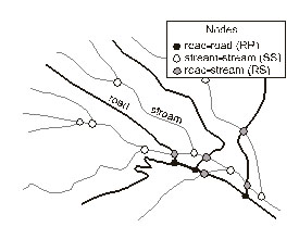
Spatial data in ArcView is held in shapefiles. One may create a shapefile showing the centrelines of all the roads within the forest operation's limits and similarly, a streams shapefile can be developed. The two shapefiles can be merged into a single shapefile whose lines depict both roads and streams not a very practical construct, admittedly, but it is a useful intermediate file which can subsequently be converted into a formal network capturing the road and stream data. The nodes of this network represent (1) the intersections of the roads, (2) the intersections (confluences) of the streams, or (3) the points where the roads and streams cross (Figure 1). The task is simply to identify this last set of nodes as being the places where bridges or culverts are likely to be found.
Figure 1. Road and stream shapefiles, and nodes.
The specific steps and ArcView commands are listed in the Appendix. In general terms, they comprise the following:
IMPLEMENTATION
With the locations identified and their coordinates established, field crews can be sent out to examine and assess the culverts (and/or bridges). The physical aspects of their current condition can be recorded, and culvert attribute tables built up in the GIS. These tables can then be queried with various questions generated by management needs. Typical questions might be:
Beyond just being used as an inventory tool, management of the culverts as facilitated by GIS can be carried through a hierarchy of taking inventory, establishing performance histories, and building performance models [2]. With sufficient records carefully accumulated over years and decades, a mature culvert management system can be built which will permit managers to predict service lives and modes of failure.
The simplest way to use GIS culvert data initially, would be to obtain an average service life from records of years-to-failure for previously installed culverts, then query the culvert database for the age of the existing culverts. Beyond that, models of failure rates due to scouring (from stream sediment bed load) and/or corrosion (from stream chemistry) can be employed.
To passively wait until culverts fail and then replace them is to adopt a policy of deliberately risking stream quality degradation and habitat destruction. By adopting a proactive approach, managers can put themselves in the position of getting ahead of the culvert management job, replacing culvert assets at the most economically opportune times, just as their counterparts in public pavement management, building maintenance management, and heavy equipment management do.
REFERENCES
[1] Haas, R., Hudson, W.R., and Zaniewski, J. 1994. Modern pavement management. Krieger Publishing Company, Malabar, Florida. 583 pp. ISBN 0-89464-588-9.
[2] Douglas, R.A. 1999. Delivery, the transportation of raw natural products from roadside to mill. New Zealand School of Forestry, University of Canterbury, Christchurch, New Zealand. pp. 107-124. ISBN 1-55131-009-0.
[3] Douglas, R.A. and McCormack, R. 1995. Pavement management systems appropriate to forest haul road networks. Proceedings XX World Congress, International Union of Forest Research Organizations (IUFRO), Tampere, Finland. August 6-12, 1995.
[4] Douglas, R.A., and McCormack, R. 1997. Pavement management applied to forest roads. Paper presented at the American Society of Agricultural Engineers (ASAE) Annual Meeting, Minneapolis, August, 1997. Paper No. 975031.
[5] Douglas, R.A., McCormack, R.J, and Winter, A.E. 1999. Management of maintenance and rehabilitation of access roads. Roads volume, Paper 9, Proceedings, Forest Engineering for Tomorrow, Edinburgh, June 28-30, 1999. UK Institution of Agricultural Engineers, Forest Engineering Group, Edinburgh. 9 pp.
[6] Winter, A.E. 1999. Developing a system for the integrated management of forest roads and transport. MSc Thesis, Australian National University. 180 pp.
[7] Winter, A.E., and McCormack, R.J. 1999. Improving forest road management. Forest Management and Water Quality, Proceedings of the Second Forest Erosion Workshop, Warburton, Victoria, Australia. Cooperative Research Centre for Catchment Hydrology Report 99/6, Croke, J., and Lane, P., eds. pp. 71-73.
APPENDIX: ARCVIEW GIS STEPS
1. Begin with a shapefile with the roads, and a shapefile with the streams.
2. Using the Geoprocessing Wizard, merge the two shapefiles into a new one.
3. Using the Data Analysis Kit (DAK 3.5.2), convert the merged shapefile into an ArcInfo coverage (Conversion : To PC ARC/INFO : From Shape).
4. Use the DAK to "Clean" (with the line option) the merged shapefile (Topology : Clean). This creates a formal network file.
5. Use the DAK command "Nodepoint" on the cleaned file to create a file of the network nodes (intersections). (Topology : Nodepoint)
6. Invoke the DAK command "Build" on the cleaned, nodepointed file, to establish the coordinates of the nodes. (Topology : Build)
7. Import the file back into ArcView, and use "Select by Theme" to query the points file for those points which are within a short distance of the roads shapefile. Then select "New Set". This establishes an intermediate file which has the RR nodes and RS nodes: the SS nodes have been eliminated.
8. Save this new set (Theme : Convert to Shapefile) as a new shapefile.
9. Repeat the search by theme command on this new shapefile to find the nodes that are within a short distance of the streams shapefile. This operation eliminates the RR nodes, leaving you with the RS nodes.
10. Save this final file (Theme : Convert to Shapefile)
The final file contains the likely locations of all the culverts (or bridges) within the maps limits.