Articles
Metallogenic Evolution of the Mackenzie and Eastern Selwyn Mountains of Canada’s Northern Cordillera, Northwest Territories:
A Compilation and Review
doi:10.12789/geocanj.2013.40.005
SUMMARY
The Mackenzie and eastern Selwyn Mountains, Northwest Territories, Canada, are the northeast expression of the Cordilleran orogen and have a geologic history that spans the last one billion years. The region has undergone a diverse tectonic evolution, which is reflected in an equally diverse collection of mineral deposits and prospects. More than 300 of these deposits and prospects have been documented in this area of the Northwest Territories and here they are categorized into mineral deposit types and their mode of formation evaluated and highlighted. Stratiform/stratabound Cu–Ag occurrences are hosted in the Neoproterozoic Coates Lake Group, generally preserved in the hanging wall of the Cretaceous Plateau fault, and define a belt through the central part of the Mackenzie Mountains. Low-grade phosphatic stratiform iron (47.5% Fe) occurs as iron formation in the Neoproterozoic Rapitan Group in the very northwest of the Mackenzie Mountains. Sedimentary exhalative Zn–Pb (± Ba) deposits are preserved in Cambrian through Devonian strata of the Selwyn Basin in the eastern Selwyn Mountains. Numerous carbonate-hosted Zn–Pb (± base-metals) occurrences are located in the Paleozoic strata of the Mackenzie Platform in the Mackenzie Mountains. Cretaceous felsic-intermediate plutons, which occur throughout the eastern Selwyn Mountains, are associated with tungsten skarn (proximal to intrusions), base-metal skarn (distal from intrusions), rare metals, semi-precious tourmaline related to pegmatites, and vein-hosted emeralds. Other resources of potential interest include coal deposits, placer gold, and possible Carlin-type gold deposits that have recently been identified farther west in the Yukon.
SOMMAIRE
Les monts Mackenzie et ceux de la chaîne orientale de Selwyn, dans les Territoires du Nord-Ouest, au Canada, sont l'expression au nord-est de l'orogène de la Cordillère, et leur histoire géologique s’étale sur le dernier milliard d’années. La région a été l’hôte d’une évolution tectonique diver-sifiée, et cela se reflète par une suite tout aussi diversifiée de gisements minéraux et d’indices prometteurs. Plus de 300 de ces dépôts et indices prometteurs ont été documentées dans cette région des Territoires du Nord-Ouest, et le présent article ils sont classés en types de gîtes minéraux, et l’attention est portée sur leur mode de formation. Les gisements de Cu-Ag stratiformes ou stratoïdes sont encaissés dans le Groupe néoprotérozoïque de Coates Lake, et ils sont généralement préservés dans l'éponte supérieure de la faille du plateau crétacé, et ils forment une bande qui traverse la partie centrale des monts Mackenzie. Le fer se retrouve dans des gisements phosphatées stratiformes à faible teneur (47,5% Fe) qui provient de formations de fer dans le Groupe néoprotérozoïque de Rapitan situé dans la pointe nord-ouest des monts Mackenzie. Des gisements sédimentaires exhalatifs de Zn-Pb (± Ba) sont préservés dans des strates cambriennes à dévoniennes du bassin de Selwyn dans la portion est des monts Selwyn. De nombreux indices de Zn-Pb (± métaux communs) dans des roches carbonatées des strates paléozoïques de la plate-forme de Mackenzie, des monts Mackenzie. Des plutons felsiques intermédiaires crétacés, qui pointent tout au long de la chaîne est de Selwyn, sont associées à des skarns de tungstène (proximaux), à des skarns de métaux communs (distaux), à des concentrations de métaux rares, de tour-maline semi-précieuses liés aux pegmatites, et à des émeraudes filoniennes. Parmi d’autres ressources d'intérêt, on retrouve des gisements de charbon, d'or alluvionnaire, et d’éventuels gisements d'or de type Carlin qui ont été découverts récemment plus à l'ouest au Yukon.
INTRODUCTION
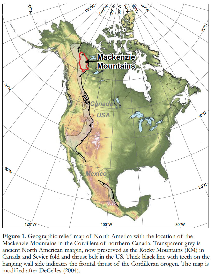
1 Mineral deposits record evidence of lithospheric-scale processes and thus provide important constraints on the tectonic evolution of a region. The Mackenzie and eastern Selwyn Mountains (MSM) of Canada’s Northwest Territories are the easternmost sub-province (Foreland belt) of the Cordilleran orogen. The MSM region is the northern extent of the Canadian Rocky Mountains and the Sevier fold-thrust belt, the now deformed ancient margin of western North America (Fig. 1; Gabrielse and Yorath 1991; Gabrielse et al. 1991; Cecile et al. 1997; DeCelles 2004). The geologic evolution of the southern parts of the Foreland belt has been well-studied and the relationship between rock units and ore deposits is well-documented (e.g., Gabrielse and Yorath 1991; Dawson et al. 1991; Gabrielse et al. 1991; Burch-fiel et al. 1992; Hutchinson and Albers 1992; Cecile et al. 1997; DeCelles 2004; Ross et al. 2005; Colpron et al. 2007; Lund 2008; Wells and Hoisch 2008). The broad-scale geologic evolution of the MSM has also been well-documented and some of the mineral deposits or deposit groups have been studied (e.g., Aitken et al. 1982; Delaney et al. 1982; Jefferson and Ruelle 1986; Yeo 1986; Gordey et al. 1991; Narbonne and Aitken 1995; Cecile et al. 1997; Goodfellow 2007; Wright et al. 2007; Pyle and Jones 2009; Turner and Long 2008; Martel et al. 2011; Rasmussen et al. 2011). Whereas many recent publications have focused on the metallogenic evolution of North American geological provinces, commodity-specific mineral deposit types, or mineral deposits as a function of particular geological events (e.g., Hart et al. 2004a, b; Dickinson 2006; Goodfellow 2007; Goodfellow and Lydon 2007; Hart 2007; Nelson and Colpron 2007; Lund 2008), the metallogenic evolution of the MSM area has not been synthesised comprehensively in such a context.
 Display large image of Figure 1
2 There are more than 300 publicly reported mineral deposits and prospects in the MSM region. In this paper, these are collated as the basis for a review of the metallogenic evolution of this vast area and a summary of our current understanding of mineral deposits in the context of sedimentary, intrusive, and tectonic events. The deposits and prospects are grouped into deposit types based on host-rock lithology, age, structural style, and ore mineralogy and are defined using overviews on similar deposit types in the literature (e.g., Hitzman et al. 2005; Goodfellow and Lydon 2007). This synthesis will help guide future mineral deposit research, allow comparison with southern equivalents (southern Canada, United States, and Mexico), and assist in searching for, and classifying, new discoveries.
REGIONAL GEOLOGY
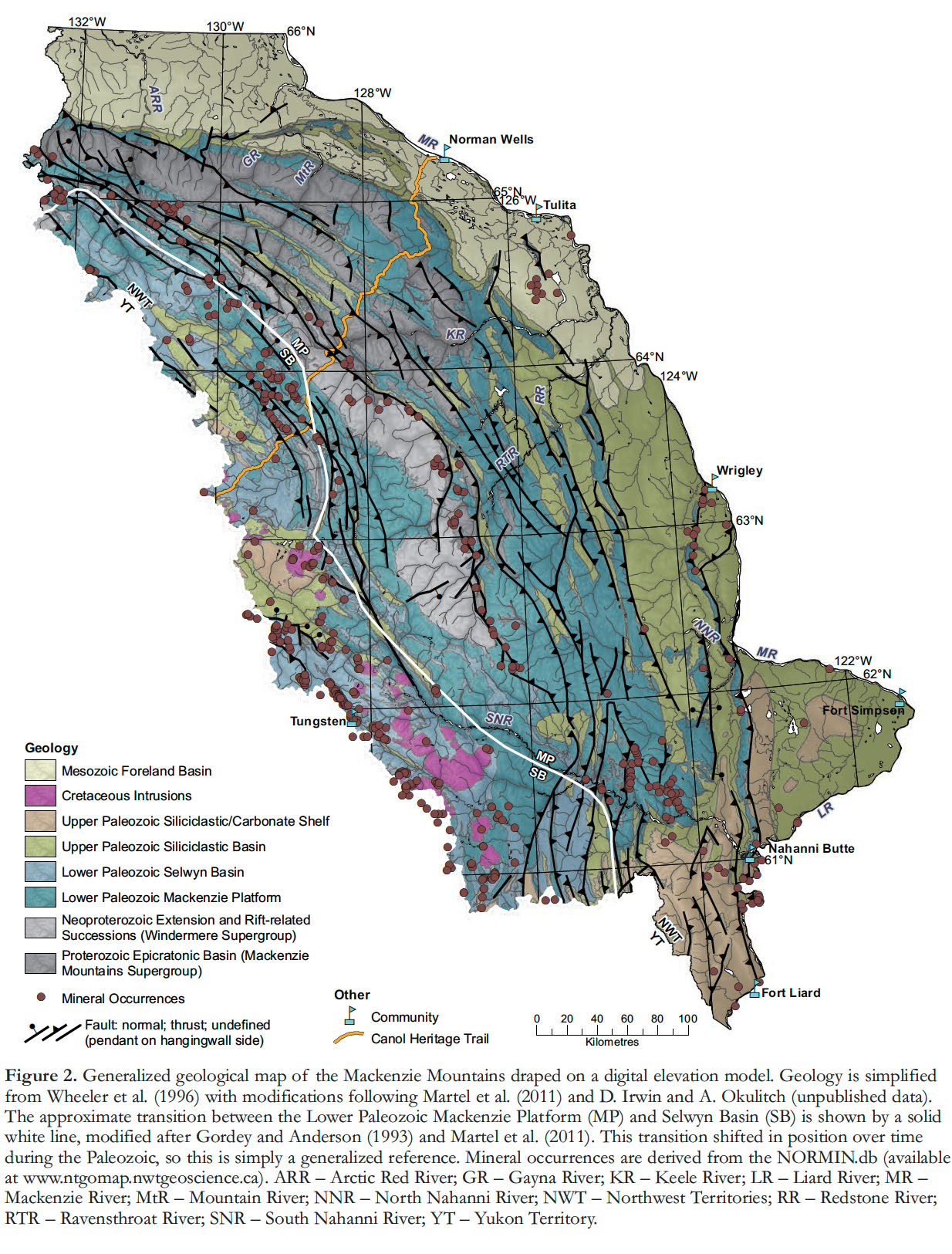
3 An overview of the geologic evolution of the Mackenzie and eastern Selwyn Mountains is provided and summarized in Figures 2 and 3 (also see Wright et al. 2007; Pyle and Jones 2009; Martel et al. 2011 and references therein). This study draws significantly upon numerous individual and group research conclusions; key references are provided and should be consulted for more detail.
 Display large image of Figure 2
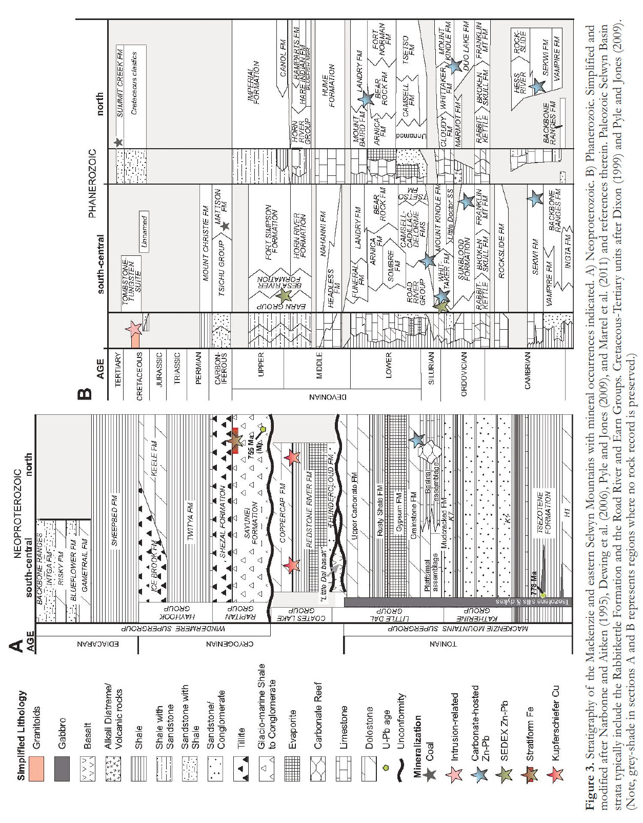 Display large image of Figure 3
4 The geological evolution of the MSM region spans about one billion years, with the oldest recognized unit being a sequence of <1083 Ma sedimentary rocks (Fig. 3; Rainbird et al. 1996). All of the metamorphic rocks in the study area belong to the greenschist or sub-greenschist facies except for contact metamorphic aureoles around Cretaceous plutons, where andalusite-bearing pelitic rocks indicate local amphibolite facies conditions (Gordey and Anderson 1993). Recognized structures include syn-sedimentary extensional faults (Aitken and Cook 1974; Eisbacher 1981; Jefferson 1983; Pyle and Jones 2009; Turner and Long 2008; Martel et al. 2011) and Cretaceous-Tertiary folds and thrust faults (Morris and Nesbitt 1998; Mair et al. 2006a; Pyle and Jones 2009; Martel et al. 2011). Post-Berriasian to Campanian strata (ca. 120 to 70 Ma) in the Mackenzie Mountains are tightly folded (Martel et al. 2011) indicating later deformation. This is supported by radiogenic Ar cooling ages on micas from ca. 95 Ma plutonic rocks indicating that uplift and unroofing persisted until at least 60 Ma (Barnes et al. 2007; Rasmussen et al. 2007). Recent earthquakes in the area indicate on-going deformation (Hyndman et al. 2005).
Neoproterozoic
5 In the MSM area, Neoproterozoic successions were deposited in extensional regimes (Narbonne and Aitken 1995; Turner and Long 2008), possibly in the vicinity of what is now Australia, Siberia, South China, Antarctica, or West Africa (Hoffman 1991; Park et al. 1995; Rainbird et al. 1996; Harlan et al. 2003; Sears and Price 2003; Li et al. 2004; Li et al. 2007; Nelson and Colpron 2007; Evans 2009). The Neoproterozoic strata can be divided into two groups; the older Mackenzie Mountains Supergroup (Long and Turner 2012; Turner and Long 2012) and the younger Windermere Supergroup (Fig. 3A; Narbonne and Aitken 1995). The 4 to 6 km-thick Mackenzie Mountains Supergroup consists of, from oldest to youngest, sedimentary rocks of the “H1-unit” (now Tobacco Formation; Turner and Long 2012), the Tsezotene Formation, and the Katherine and Little Dal Groups (Fig. 3A; Long et al. 2008; Martel et al. 2011). Uranium-lead detrital zircon populations with ca. 1083 Ma and 1010 Ma dates from the Katherine Group provide a maximum age of deposition (Rainbird et al. 1996; Leslie 2009). A 778 Ma gabbro plug south of Coates Lake (Jefferson and Parrish 1989) and the cross-cutting ca. 780 Ma Tsezotene sills (Harlan et al. 2003) provide a minimum age for the Mackenzie Mountains Supergroup. The Tsezotene sills are associated with the “Little Dal basalts” and are part of the Gunbarrel event (Dudás and Lustwerk 1997; Harlan et al. 2003). Stratigraphy, sedimentology, and regional correlations indicate that the overall depositional setting for the Mackenzie Mountains Supergroup was likely an epicra-tonic basin (Narbonne and Aitken 1995; Long et al. 2008; Turner and Long 2008).
6 The Coates Lake Group is a sequence of sabkha- and lagoon-related sedimentary rocks that were deposited in a terrestrial rift environment (Jefferson and Parrish 1989). The Coates Lake Group is positioned unconformably above the Little Dal Group and Little Dal basalt and is unconformably overlain by the Rapitan Group of the Windermere Supergroup (e.g., Eisbacher 1978; Jefferson and Ruelle 1986; Dudás and Lustwerk 1997).
7 The 5 to 7 km-thick, rift-related Windermere Supergroup unconformably overlies the Coates Lake Group and the Mackenzie Mountains Supergroup (Fig. 3A; Eisbacher 1978; Narbonne and Aitken 1995). From the base upward, the Windermere Supergroup in the MSM includes the <755 Ma glacial marine/rift-related Rapitan Group (Yeo 1981; Ross and Villeneuve 1997), the deep-water, shaly Twitya Formation, shallower-water carbonate and siliciclastic strata of the Keele Formation, the glacial-related Ice Brook Formation, deep water shale and turbidites of the Sheepbed Formation, platformal carbonate strata of the Gametrail Formation, thick shallow-water, terrigenous, clastic strata of the Blueflower Formation, and the poorly exposed, shallow-water, carbonate-dominated rocks of the Risky Formation (Fig. 3A; Narbonne and Aitken 1995; MacNaughton et al. 2008).
Paleozoic
8 The Neoproterozoic–Cambrian boundary is preserved in the main ranges of the Mackenzie Mountains, but sub-Cambrian erosion has cut progressively downward east to the mountain front, where Cambrian strata directly overlie lower units of the Mackenzie Mountains Supergroup. The Cambrian through Devonian (with minor Permian) strata were deposited on the Neoproterozoic strata in an evolving passive margin. In general, the sedimentary rocks are preserved as platformal facies in the northeast (Mackenzie Platform) and basinal facies to the southwest (Selwyn Basin; Figs. 2 and 3B; Morrow 1991; Gordey and Anderson 1993; Cecile et al. 1997).
9 Paleozoic platformal sedimentation was complex and influenced by variations in crustal thicknesses inherited from sub-Windermere and Cambrian extension (Cecile et al. 1997; Hadlari et al. 2012). This led to sedimentation on a number of segmented platforms, arches, and basins, resulting in numerous formations with complex lateral thickness variations and facies relationships. For simplicity, this is referred to collectively as the Mackenzie Platform (Fig. 2; Morrow 1991; Gordey and Anderson 1993; Cecile et al. 1997; Martel et al. 2011). The oldest Cambrian strata in the Mackenzie Platform consist of shallow-marine to flu-vial quartz sandstone (Backbone Ranges Formation). This is overlain by shallow-water Cambrian to Devonian dolostone and limestone assigned to various formations (e.g., Sekwi, Rock-slide, Broken Skull, Sunblood, Franklin Mountain, Mount Kindle, Tsetso, Camsel, Sombre, Arnica, and Bear Rock Formations; Fig. 3B), and capped by Middle Devonian open-marine fossiliferous limestone (e.g., Landry, Grizzly Bear, Headless, Nahanni, and Hume Formations; see Morrow 1991; Gordey and Anderson 1993; Pyle and Jones 2009; Martel et al. 2011). A significant feature of the Mackenzie Platform is the Mackenzie Arch, a northwest-trending locus of coalescing unconformities and formational thinning. East of the arch, formation thicknesses increase, but only modestly, and then farther east units thin again to merge with unfolded Paleozoic platform cover of the craton (Interior Platform; e.g., Cecile et al. 1997). West of the arch the platformal units increase substantially in thickness to the facies transition into the Selwyn Basin (Morrow 1991).
10 The relatively deeper water Selwyn Basin strata were deposited concomitantly with the sedimentary rocks on the Mackenzie Platform. The oldest exposed units in the Selwyn Basin are thick, turbiditic, clastic rocks of the Neoproterozoic through Cambrian Hyland Group. Lower and Middle Cambrian shales are sparsely preserved beneath the sub-Upper Cambrian unconformity. The Upper Cambrian is marked by basinal limestone of the Rabbitkettle Formation (Fig. 3B). Ordovician to Devonian strata are dominated by siltstones, shales, and cherts of the older Road River Group and younger Earn Group (Fig. 3B; Gordey and Anderson 1993; Pyle and Jones 2009; Martel et al. 2011).
11 During the Late Devonian to Mississippian there was an abrupt change in deposition style, reflecting complex tectonic events (e.g., Colpron et al. 2007; Lemieux et al. 2011). The lack of evidence of compressional deformation, the presence of local syn-sedimentary normal faults and of local felsic volcanic rocks are interpreted to reflect extension or transtension. As Devono–Mississippian tectonism waned, clastic sedimentation was succeeded by lower Mississippian mixed carbonate and siliclastic strata likely deposited on a muddy, shallow-marine shelf (Tsichu Group, Cecile 2000; Mattson Formation, Potter et al. 1993; Fig. 3B). Preservation of Carboniferous to Permian strata is fragmentary and limited to the westernmost and southern parts of the Mackenzie Mountains (Fig. 3B; Gordey and Anderson 1993; Martel et al. 2011).
Mesozoic
12 Triassic and Cretaceous sedimentary units are only preserved locally (Figs. 2 and 3B). The Cretaceous strata are foredeep deposits that reflect the collisional evolution of the continental margin to the west (Coney et al. 1980; Mair et al. 2006a; Martel et al. 2011). Mesozoic igneous rocks are dominated by intermediate to felsic, ca. 110 to 90 Ma Cretaceous plutons that intruded Proterozoic and Paleozoic Selwyn Basin strata within the Selwyn Mountains (Figs. 2 and 3B; Hart et al. 2004a, b; Rasmussen et al. 2007). The plutons represent the southeastern extent of the Tombstone–Tungsten Suite (Hart et al. 2004a), and are interpreted to have formed in a distal, back-arc setting in response to collision of the Peninsular–Alexander–Wrangellia Superterrane with the western margin of North America (Mair et al. 2006a).
METHODS AND MATERIALS
13 The mineral prospects and deposits in the MSM area are documented in the Northern Minerals database (NORMIN), which is available through the NWT Geoscience Office’s GoMap web portal (http://www.nwtgeo-science.ca). Mineral occurrence data in Yukon are available through the Yukon Geological Survey’s website (http://www.geology.gov.yk.ca), and are not discussed further. The data in NORMIN are derived from the submission of assessment reports on mineral claims (publicly available assessment reports can be obtained through the NWT Geoscience Office website), and from published maps or written publications. Other supplementary data are from Wright et al. (2007), Ootes et al. (2007), Mercier et al. (2008), Ootes and Martel (2010), and Martel et al. (2011).
14 NORMIN was used as a guide for classifying all of the documented mineral occurrences from the Mackenzie and eastern Selwyn Mountains. Classification involved comparing host rocks, structural style (e.g., stratiform versus fault-hosted), commodities recorded (e.g., Zn–Pb versus Cu–Ag), and geographic location (e.g., Mackenzie Platform versus Selwyn Basin). Many of the significant prospects and deposits have been visited by the authors since 2003, yielding a classification scheme that is based on extensive, recent, and internally consistent field observations.
15 Five mineral deposit types are recognized and discussed in this paper. Assignment of deposits to mineral deposit types was based on published reports on the deposits themselves or on related deposits elsewhere. Key references to this literature are included in the text. Where necessary, overviews of each type are discussed in the context of their host geology. In some cases our classification scheme is straight forward (e.g., iron formation contains stratiform Fe). However, individual occurrences of carbonate-hosted, SEDEX, and intrusion-related deposits may be far more complex than this simple classification indicates. Finally, the intrusion-related deposits include a diverse set of styles such as multiple skarn types and semi-precious gem-stones. The mineral deposit types are discussed chronologically in their tectono-stratigraphic context to illuminate the metallogenic evolution of this vast region.
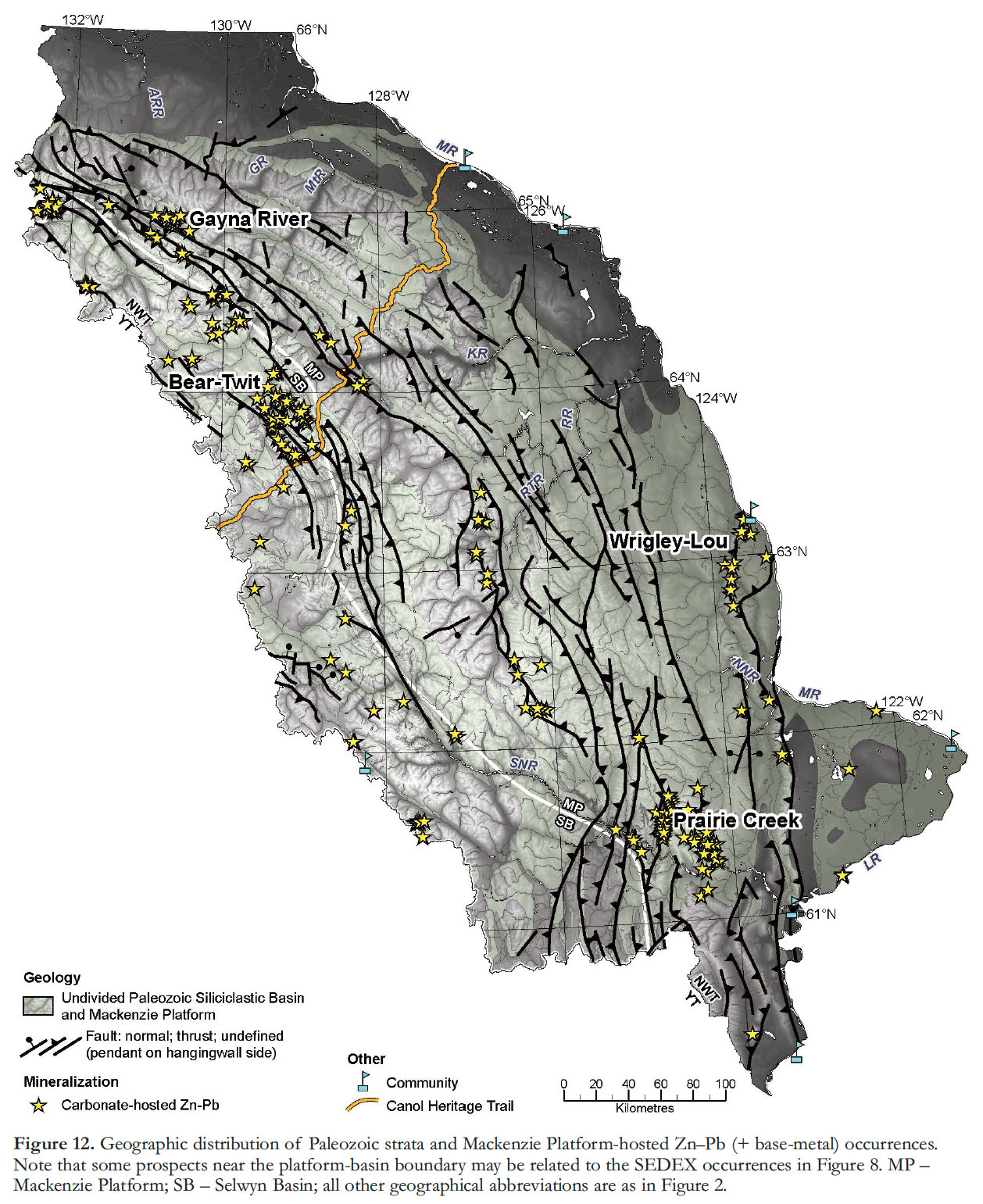
16 In Canada, since 2001, valid ore resource calculations must have employed the methodology set out by National Instrument 43-101 of the Canadian Institute of Mining and Metallurgy (http://web.cim.org/standards/MenuPage.cfm?sections=177&menu=178) and developed by the Canadian Securities Administration. Therefore, resource estimates that predate this, or have not been published under these guidelines, are considered herein as ‘historical’ resource estimates, indicating they do not meet NI-43-101 standards, and the reported data may not accurately represent the mineral deposits in question.
METALLOGENIC EVOLUTION
Red-bed or Kupferschiefer-type Cu (± Ag)
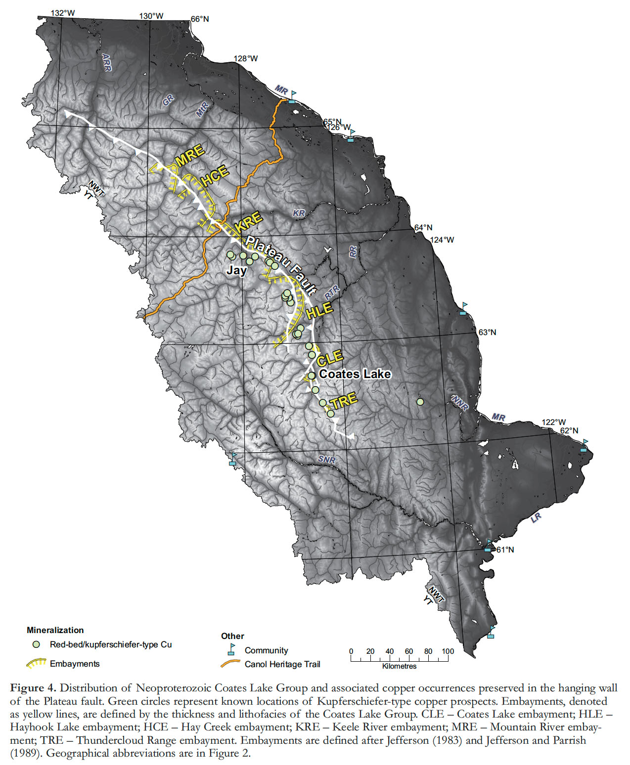
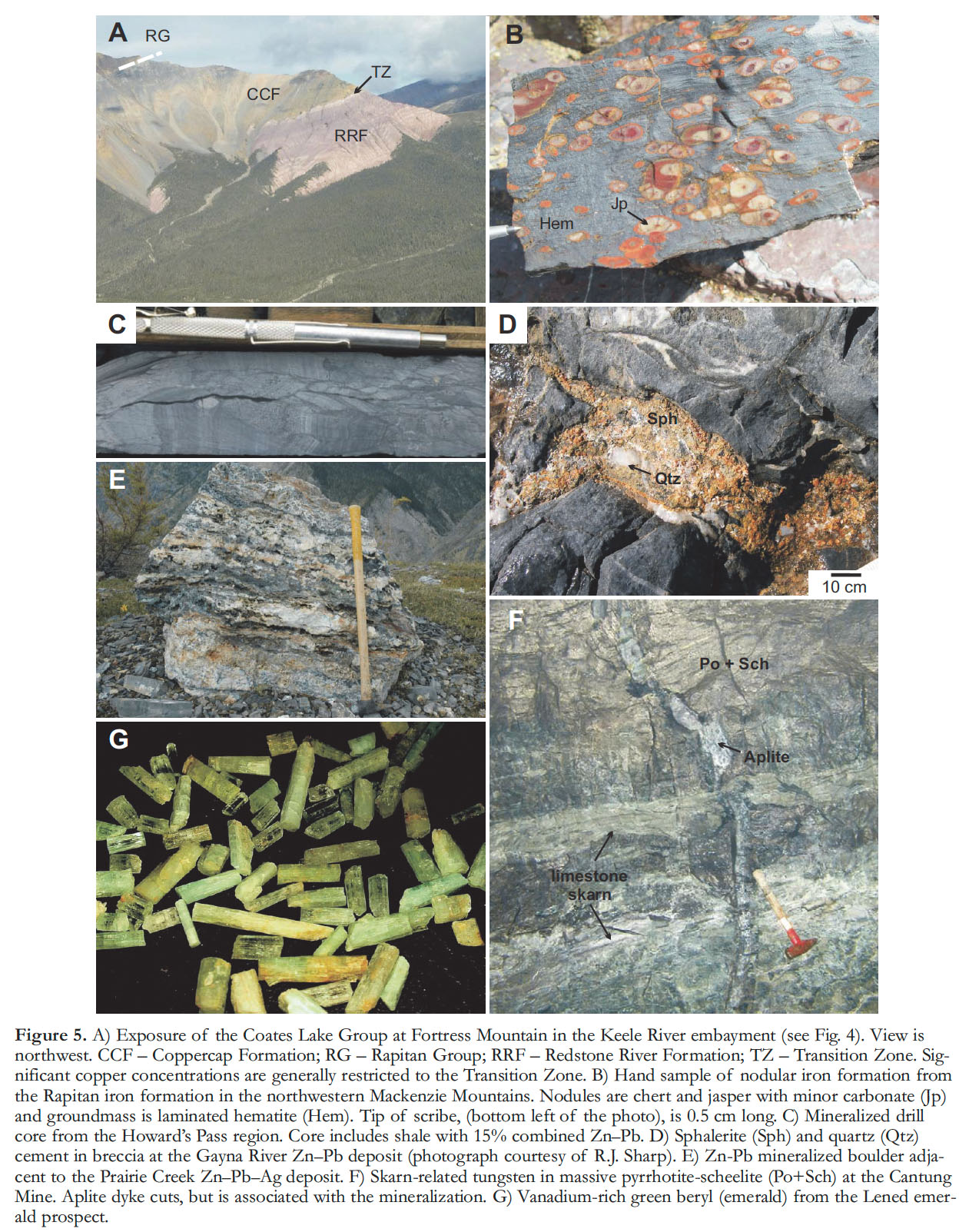
17 The oldest recognized mineral deposit type in the MSM is stratabound copper hosted by the <780 Ma Coates Lake Group (Fig. 3A). This region is commonly referred to as the Redstone copper belt, and the mineralization is generally preserved in the hanging wall of the Plateau fault (Fig. 4). The Coates Lake Group is divided into three formations; alluvial-fan and playa-lake deposits of the Thundercloud Formation grade into the overlying sabkha deposits of the Redstone River Formation, which is overlain by marine carbonate rocks of the Coppercap Formation (Figs. 3 to 6; Jefferson 1983; Jefferson and Ruelle 1986).
 Display large image of Figure 4
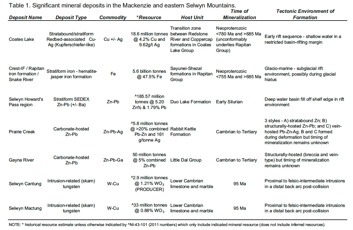 Display large image of Table 1
18 Exposures of the Coates Lake Group are restricted to the central part of the Mackenzie Mountains and this unit is thickest at Coates Lake (Fig. 4; Aitken 1977; Jefferson and Ruelle 1986; Colpron and Jefferson 1998; Jefferson and Colpron 1998). In the northern Mackenzie Mountains, the succession pinches out rapidly and may have been eroded prior to deposition of the overlying Rapitan Group; scattered remnants are found as far north as 64º45’ N (Fig. 4; Eisbacher 1981; Jefferson and Parrish 1989; Martel et al. 2011). South of Coates Lake, the Coates Lake Group may be present in the subsurface, but its extent is unknown. Thickness and lithofacies patterns in the Coates Lake Group define a series of depositional embayments (Fig. 4; Jefferson 1983; Jefferson and Parrish 1989) caused by syn-depositional normal faulting that formed a series of half-grabens (Eisbacher 1981; Jefferson and Ruelle 1986; Jefferson and Parrish 1989). This extensional activity was probably related to incipient opening of the paleo-Pacific Ocean and the first stage of Rodinia break-up (e.g., Colpron et al. 2002; Li et al. 2007).
19 At least 25 Cu (± Ag) occurrences are recognized (Fig. 4), of which the deposit at Coates Lake is the most significant. Historic resource estimates suggest that it contains 33.6 million tonnes grading 3.9% Cu and 9 g/t Ag (Table 1; Hitzman et al. 2005). A thorough review of the deposit geology is provided by Chartrand and Brown (1985), Jefferson and Ruelle (1986), and Chartrand et al. (1989). The Jay prospect to the north is currently the second-most-significant deposit, with a historic resource estimate of 1.2 million tonnes at 2.7% Cu (Hitzman et al. 2005).
20 Very low-grade disseminated copper sulphide mineralization is widespread, but the most noteworthy copper occurrences are generally stratabound or stratiform lenses in the “Transition Zone” between the Redstone River and Coppercap Formations (Figs. 3A, 5A, and 6; Jefferson and Ruelle 1986). The relationship between ore bodies and host rocks indicates that these deposits are of the Kupferschiefer-type (Hitzman et al. 2005). Ore mineralization in the district is believed to be the result of fluid mobilization in an actively extending basin (Fig. 6; Jefferson and Ruelle 1986; Chartrand et al. 1989), a concept that is supported by sedimentary and ore textures, which suggest that mineralization took place during very early diagenesis (Jefferson and Ruelle 1986; Chartrand et al. 1989). Copper and associated metals were liberated by oxidation of metals present in aquifer rocks, transported in either compaction-derived or meteoric, recharge-related chloride brines through sulphate-bearing red-beds, which then interacted with a reducing interface to precipitate sulphides (Fig. 6; Chartrand et al. 1989; Brown 2005; Hitzman et al. 2005). This interface is the Transition Zone between the Redstone River and Coppercap Formations, and an upward zoning from copper-rich to copper-poor ore minerals indicates sub-vertical fluid flow (Fig. 6B; Jefferson and Ruelle 1986). The copper source is suggested by Chartrand et al. (1989) to be the now red and oxidized evaporitic beds of the Redstone River Formation, or the volcaniclastic conglomerates of the underlying Thundercloud Formation. It is likely that the underlying “Little Dal basalt” (Dudás and Lustwerk 1997) provided most of the copper, which was either leached directly from the basalt, or liberated from volcanic detritus in overlying units (e.g., Thundercloud Formation; Figs. 3A and 6A).
 Display large image of Figure 5
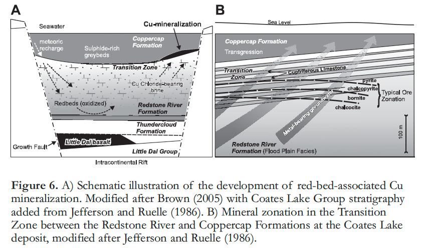 Display large image of Figure 6
21 Numerous red-bed or Kupferschiefer-type copper deposits are known globally (Hitzman et al. 2005), but North American deposits that are temporal equivalents of the Coates Lake Group copper deposits remain unrecognized. On a global scale, the most similar occurrence may be the Zambian Copperbelt (e.g., Hitzman et al. 2005). This copper belt is Neoproterozoic, has a similar rift-like environment of deposition and mineralization, and is overlain by glaciogenic rocks (e.g., Hitzman et al. 2005; Selley et al. 2005). A recent paleo-reconstruction of Rodinia by Evans (2009), an alternative to that of Li et al. (2007), places Africa adjacent to northwestern Laurentia at 780 Ma; according to this model, the Zambian Copperbelt may have formed adjacent to the Coates Lake Group, on the opposite side of a rift. Conversely, recent geochronological constraints on the Zambian Copperbelt, and possible constraints presented in this study, indicate that it may be ca. 50–100 million years older than the Coates Lake Group (Johnson et al. 2007).
Stratiform Iron Formation
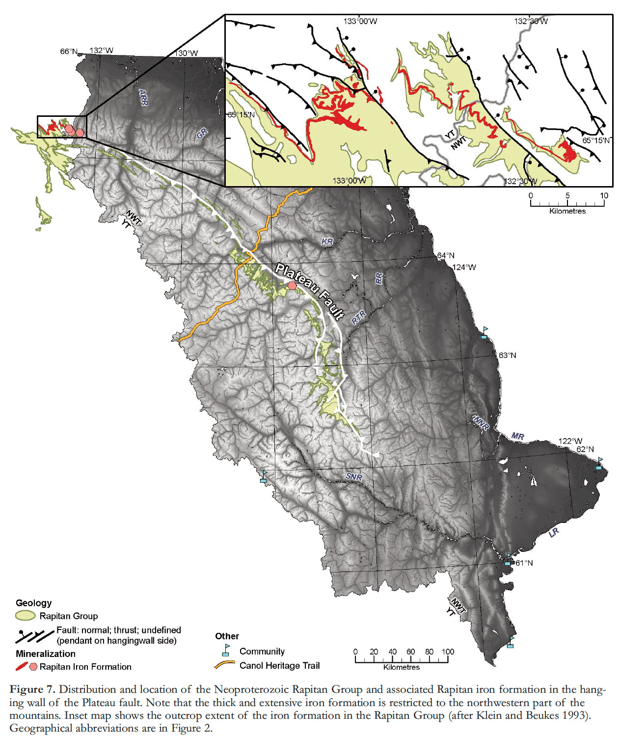
22 In the MSM, stratiform iron deposits consist of hematite-jasper layers (Fig. 5B; e.g., Clout and Simonson 2005; Bekker et al. 2010) within the Neoproterozoic Rapitan Group, a glacial-marine sedimentary succession near the base of the Windermere Supergroup (Fig. 3A; Eisbacher 1978, 1981; Yeo 1981, 1986; Klein and Beukes 1993; Hoffman and Halverson 2011; Hoffman et al. 2011; Baldwin et al. 2012). The Rapitan Group unconformably overlies either the Coates Lake Group, or Little Dal Group and was deposited after 750 Ma, the age of a granitic dropstone in tillite (Ross and Villeneuve 1997) and prior to 685 Ma, deduced by correlation to glacial equivalents in Idaho (Lund et al. 2003; Fanning and Link 2004). Park (1997) used paleomagnetic poles and ages of the Franklin Sills to indicate deposition at low paleolatitudes at ca. 725 Ma for the Rapitan Group. Using regional correlations with the Shaler Supergroup, Young (1992) suggested that the iron formation is younger than 723 Ma (also see Rainbird et al. 1996), which is supported by U–Pb zircon ages of interbedded tuffs and dropstones in correlative strata in Idaho (<717 Ma; >685 Ma; Lund et al. 2003; Fanning and Link 2004) and a ca. 716 Ma interbedded tuff from correlated rocks in Yukon (Macdonald et al. 2010). On a grand scale, these glacial marine rocks are associated with the contested Sturtian snowball Earth episode (e.g., Hoffman and Schrag 2002; Young 2002; Eyles and Januszczak 2004; Har-land 2007; Macdonald et al. 2010), the nature of which has been questioned as the result of recent radiometric agedating (e.g., Lund et al. 2003; Kendall et al. 2006; Azmy et al. 2008).
23 The Rapitan Group consists of three formations. Diamictite of the Mount Berg Formation is overlain by the Sayunei Formation, a dominantly maroon-weathering siltstone with lesser conglomerate, sandstone, and diamictite. The uppermost Shezal Formation is dominated by green-weathering (with lesser maroon) diamictite (Fig. 3; Eisbacher 1981; Yeo 1981, 1986; Klein and Beukes 1993). Eisbacher (1981), Klein and Beukes (1993), and Hoffman and Halverson (2011) place the iron formation at the top of the Sayunei Formation (Fig. 3A), whereas Yeo (1981, 1986) and Baldwin et al. (2012) place this unit predominantly within the Shezal Formation. It is possible that the thick iron formation in the northern Mackenzie Mountains may not be stratigraphically equivalent to other, thinner iron-formation exposures farther south (Fig. 7) within the Sayunei Formation.
 Display large image of Figure 7
24 Although some iron formation is locally present along the strike length of the exposed Rapitan Group (Fig. 7; Eisbacher 1981; Yeo 1986; Klein and Beukes 1993; Hoffman and Halverson 2011; Baldwin et al. 2012), the thickest and most exciting exposure, from a mineral deposit perspective, is located in the very northwest part of the Mackenzie Mountains in both Yukon and NWT (Fig. 7), in the Cranswick River–Iron Creek sub-basin. In this area, the iron formation is exposed over a strike length of 40 km, with thicknesses up to 100 m (Yeo 1986; Klein and Beukes 1993), and is referred to as ‘Crest-IF’, ‘Rapitan iron formation’, or the ‘Snake River deposit’. The iron formation is composed of rhythmically bedded hematite containing chert-jasper nodules (Fig. 5B) with lesser interbedded and banded hematite-jasper (i.e., banded iron formation).
25 Sedimentological and geo-chemical data were used by Yeo (1986) to attribute the source of iron to rift-related hydrothermal plumes. That study suggested that, although glaciers were present, deposition of the iron formation was not related to glaciation (Fig. 8A). This view is supported by Young (2002) who pointed out that the thick glacial deposits of the Shezal Formation overlie the iron formation. Klein and Beukes (1993), on the basis of Eu and other rare-earth elements, trace elements, and stable isotope data inferred deposition of the Rapitan iron formation in water chemically more similar to modern ocean water, than was the case for earlier Proterozoic and Archean iron formations (Klein and Beukes 1993; Klein and Ladeira 2004; Klein 2005). This suggests that although rift-related hydrothermal plumes may have been the source of the iron, the iron was concentrated and then diluted in ocean water due to sub-glacial anoxic conditions during the Sturtian snowball Earth (Fig. 8B). Coupled with sedimentological insights, Klein and Beukes (1993) suggest that the iron was then precipitated during glacial retreat and subsequent oxygenation of the ocean (Fig. 8B). A more complex mechanism of iron formation precipitation is suggested by Baldwin et al. (2012). Using REE+Y and Mo–U geochemical constraints and bedrock observations they suggest that the iron was derived from glacier-related, terrigenous sediment rather than from hydrothermal fluids. In this model dissolved iron created increasingly ferruginous conditions in an ice-capped semi-restricted basin. Iron precipitation occurred during glacial retreat and was related to upwelling of dissolved iron, which interacted with the top layer of progressively oxygenated waters (Baldwin et al. 2012). We have observed dropstones in the iron formation as well as in an underlying glacially-derived diamictite and the overlying Shezal tillite. This likely indicates a more dynamic ice environment of glacial retreat and advance, including meltout from calved icebergs and possibly multiple periods of open water and water column overturning. Overall, it seems unquestionable that the iron formation was related to glaciation, but the source of iron and its mechanism of deposition may require further study.
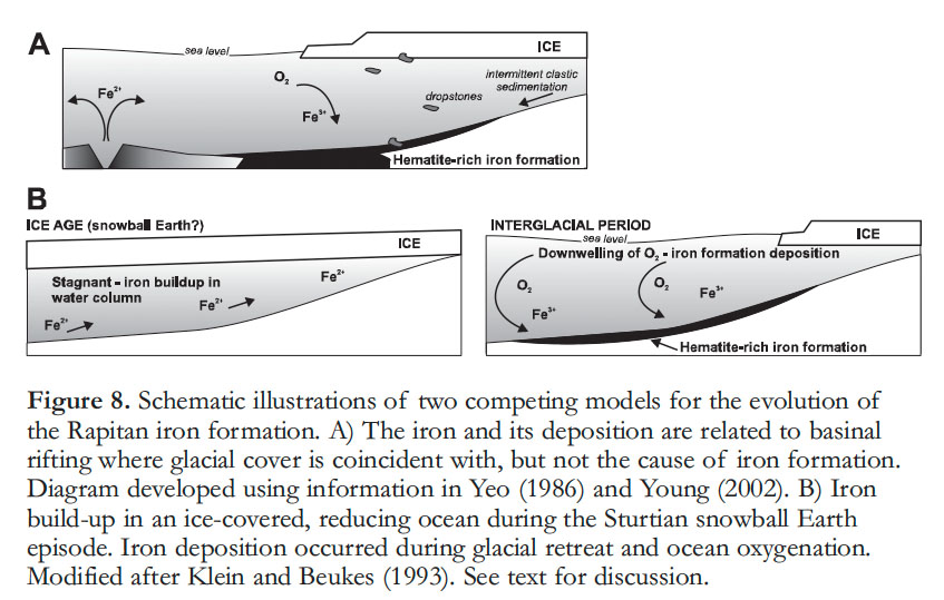 Display large image of Figure 8
26 The Crest iron formation has a drilled historical resource estimate of 5.6 billion tonnes of ~47% Fe (Iron Creek area, Yukon; Fig. 7; Table 1), with a regional resource estimated at >10 billion tonnes (Gross 1970). This iron deposit is probably the largest in western North America and the largest undeveloped deposit in North America (Gross 1970; Klemic 1970). It remains uneconomic to exploit due to the current lack of infrastructure in the region. Possible analogues to the Rapitan iron formation are summarized by Yeo (1986), Young (2002), Klein (2005), and Hoffman et al. (2011).
SEDEX Zn–Pb (± Ag, Ba)
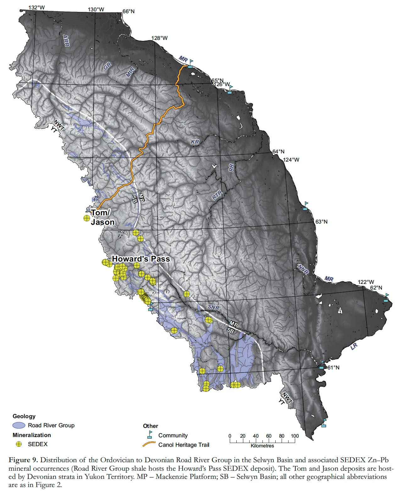
27 Stratiform sedimentary exhalative (SEDEX; Leach et al. 2005) Zn–Pb deposits are present in Cambro–Silurian and Devonian siliciclastic rocks (shale) in the Selwyn Basin (Fig. 9). These SEDEX deposits have been thoroughly reviewed by Leach et al. (2005), Goodfellow (2007), and Good-fellow and Lydon (2007), and are only briefly discussed here. In addition to these reviews, Fernandes (2011) presents new data on barite-rich SEDEX deposits in this region. Three temporally distinct SEDEX districts are recognized; the Cambrian-hosted Anvil district in Yukon (Pipage 2004; not discussed further), the Early Silurian Howard’s Pass district (Godwin and Sinclair 1982; Godwin et al. 1982; Norford and Orchard 1983; Goodfellow 2007), and the Late Devonian MacMillan Pass district that hosts the Tom and Jason deposits (Fig. 9; Ansdell et al. 1989; Turner 1991; Gordey and Anderson 1993; Goodfellow 2007; Goodfellow and Lydon 2007; Fernandes 2011).
 Display large image of Figure 9
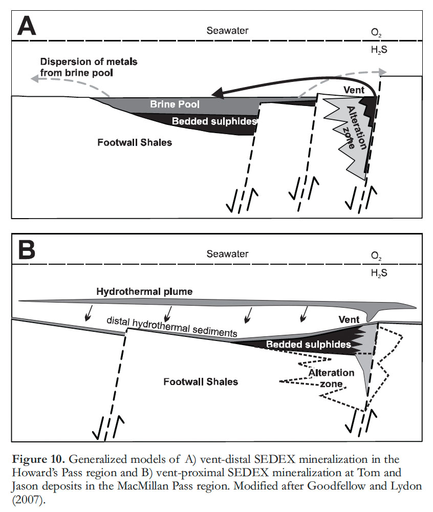
28 The Howard’s Pass deposits are hosted by the Early Silurian Road River Group (Norford and Orchard 1983; Figs. 5C and 9), a regionally extensive succession of shale, chert, and minor limestone. These Selwyn Basin strata are deeper water successions than the laterally equivalent slope and platform facies of the Mackenzie Platform to the east (Gordey and Anderson 1993; Goodfellow 2007; Martel et al. 2011). Howard’s Pass contains an overall drill-indicated resource of 185.57 Mt @ 5.20 Zn% and 1.79% Pb from >10 individual deposits (Selwyn Chihong Mining Ltd. 2012; Table 1). The ore mineralogy is mostly sphalerite and galena with little to no iron sulphide. The ore mineralogy and geology suggest that the Howard’s Pass deposit was formed in a hydrothermal vent-distal mineralizing environment (Fig. 10A; Goodfellow 2007; Goodfellow and Lydon 2007). Most of the well-defined deposits of this district are in the Yukon but straddle the border with the Northwest Territories; the laterally equivalent deposits in the Northwest Territories are relatively under explored. The only larger SEDEX deposits in North America are the past-producing Mesoproterozoic Sullivan deposit in British Columbia and the producing Mississippian Red Dog deposit in Alaska (Goodfellow and Lydon 2007). Howard’s Pass currently is the single largest, undeveloped zinc district in the world and is second only to Red Dog in total zinc (e.g., Leach et al. 2005).
 Display large image of Figure 10
29 The Tom and Jason SEDEX deposits are hosted in the Devonian Earn Group in the MacMillan Pass district near the Yukon – NWT border (Fig. 9; Bailes et al. 1986; McClay and Bidwell 1986; Ansdell et al. 1989; Goodfellow and Rhodes 1991; Turner 1991; Gordey and Anderson 1993; Goodfellow and Lydon 2007). This region appears to be significantly less enriched in Zn and Pb than Howard’s Pass; historical resource estimates for the Tom deposit indicate 15.7 Mt @ 7% Zn, 4.6% Pb, and 49 g/tonne Ag (McClay and Bidwell 1986), and for the Jason deposits 14.1 Mt @ 7.1% Zn, 6.6% Pb, and 80 g/tonne Ag (Bailes et al. 1986). Unlike Howard’s Pass, this area does contain significant Ba and Ag (Bailes et al. 1986; McClay and Bidwell 1986; Ansdell et al. 1989; Goodfellow and Rhodes 1991; Turner 1991). Tom and Jason contain tetrahedrite (carrying Ag) in addition to extensive pyrite, pyrrhotite, galena, sphalerite, and lesser arsenopyrite, a result of a complex and laterally zoned vent facies mineralizing environment (Fig. 10B; Bailes et al. 1986; McClay and Bidwell 1986), versus the vent distal environment for Howard’s Pass (Goodfellow and Lydon 2007). At Tom and Jason, the mineralization more distal from the vent contains less Pb–Zn–Ag, but higher Ba in interbedded barite-chert beds (e.g., Bailes et al. 1986; McClay and Bidwell 1986; Turner 1991).
30 The SEDEX mineralization is thought to have resulted from mixing of chloride-rich, oxidized, metalliferous fluids with H2 S-bearing (reducing) fluids in both vent-distal (Howard’s Pass; vent not yet discovered) and vent-proximal settings (MacMillan Pass; Fig. 10; Turner 1991; Goodfellow 2007). Based on stable and radiogenic isotopic constraints, the ore-bearing fluids were likely derived from fluids circulating through North American basement (Godwin and Sinclair 1982; Goodfellow 2007; see radiogenic Pb data in Fig. 11 for SEDEX deposits) that were focused and discharged along syngenetic extensional faults, and were vented into the water column (Fig. 10; Bailes et al. 1986; McClay and Bidwell 1986; Goodfellow and Rhodes 1991; Turner 1991; Goodfellow 2007; Good-fellow and Lydon 2007). The overall tectonic setting for SEDEX deposits in the Selwyn Basin is described as a reactivated rift for the Early Silurian Howard’s Pass vent-distal Zn–Pb and a back-arc setting for the Late Devonian MacMillan Pass vent-proximal Zn–Pb–Ag-Ba deposits (Nelson et al. 2002, 2006; Goodfellow and Lydon 2007).
 Display large image of Figure 11
31 Although the Howard’s Pass deposits have many features similar to other large SEDEX deposits (see Leach et al. 2005; Goodfellow and Lydon 2007), there does not appear to be a temporal relationship with any of these globally (see Table 1 in Goodfellow and Lydon 2007). The MacMillan Pass deposit has similarities consistent with typical stratiform Zn–Pb–Ba deposits (e.g., Ansdell et al. 1989) and are temporally similar to other Ba-rich Devonian–Mississippian prospects in the Selwyn Basin (e.g., Fernandes 2011), the Cirque SEDEX deposit in northern British Columbia (Goodfellow and Lydon 2007), and possibly to the Pine Point and Robb Lake Mississippi Valley-type (MVT) deposits (Nelson et al. 2002). Previous studies imply that the Selwyn Basin-hosted SEDEX and Mackenzie Platform-hosted Zn–Pb deposits may have formed contemporaneously (e.g., Nelson et al. 2002). Precise age data are not available for most of the carbonate-hosted Zn–Pb occurrences in the MSM area, and therefore it is not currently possible to evaluate this concept.
Carbonate-hosted Zn–Pb (± Cu, Ag, Ba, Sb, Ga)
32 Over 230 Zn–Pb (± Cu, Ag, Ba, Sb, Ga) prospects and deposits are present throughout the MSM area in the Paleozoic Mackenzie Platform that formed east of the Selwyn Basin (Fig. 12; Martel et al. 2011). The mineralogy within this ‘Mackenzie Mountains Zinc District’ commonly includes sphalerite, smithsonite, and galena, with variable amounts of barite and copper-sulphide/sulphosalts. Fluid-inclusion data indicate temperatures of formation from 160° to >200°C (Fraser 1996; Carrière and Sangster 1999; Gleeson 2006; Paradis 2007; Wallace 2009). Such deposits are referred to here as ‘carbonate-hosted’ rather than MVT due to these elevated temperatures of formation (cf. Hewton 1982; Nelson et al. 2002; Goodfellow 2007; Leach et al. 2005; Paradis et al. 2007; Lund 2008). As Paradis (2007) and Wallace (2009) point out, however, many other aspects of these mineralized zones are consistent with the MVT classification (Leach et al. 2005; Paradis et al. 2007).
33 The key carbonate-hosted, base-metal deposits in the MSM area are Gayna River, Bear–Twit, Prairie Creek, and potentially Wrigley–Lou (Figs. 5D-E and 12; Heal 1976). Gayna River is in the northern Mackenzie Mountains (Fig. 12), and is characterized by breccia-cemented, gallium-rich sphalerite (Fig. 5D) with lesser pyrite and hematite, hosted in the Neoproterozoic Little Dal Group (Hewton 1982; Dewing et al. 2006; Wallace 2009). An historical resource estimate of 50 million tonnes with over 5% combined Zn–Pb is reported by Hewton (1982; Table 1), although the overall tonnage is probably exaggerated (Wallace 2009). The Bear–Twit prospect, southeast of Gayna River (Fig. 12), contains Zn–Pb–Cu–Ag (sphalerite, galena, tetrahedrite) in veins that cross-cut Paleozoic strata (Dewing et al. 2006). Bear–Twit has an historical resource estimate of 7 million tonnes @ 5.4% Zn, 2.6% Pb, and 17.1 g/t Ag, although the overall tonnage may be over-estimated (Dewing et al. 2006). Prairie Creek, in the southern Mackenzie Mountains (Fig. 12), contains stratabound, sphalerite-galena-bearing ore (Fig. 5E) hosted in the Ordovician Whittaker Formation as well as late, Ag-rich, Pb–Zn veins that crosscut early Paleozoic carbonate rocks and shale (Paradis 2007). Canadian Zinc Corporation is in the process of developing a mine plan for the Prairie Creek Zn–Pb–Ag deposit, and report a measured resource of 5.8 million tonnes @ 20% Zn–Pb and 212 g/t Ag (Table 1).
 Display large image of Figure 12
34 Comparisons among the deposits and prospects in the MSM area are difficult owing to differences in host-rock age (Fig. 3B), mineralogy, and alteration. There is an array of different mineralization styles, even within individual occurrences (cf. Nelson et al. 2002; Lund 2008). An emerging hypothesis is that some of the carbonate-hosted Zn–Pb occurrences, such as Gayna River, were influenced by northeast-trending faults (present co-ordinates) that were active during deposition of Neoproterozoic strata (Aitken and Cook 1974; Turner and Long 2008. Later fluids may have used these structures to access favourable structural or lithostratigraphic depot-zones (Turner and Long 2008). This relationship may be similar to that of the Pine Point MVT – MacDonald Fault relationship to the east (Hannigan 2007).
35 In contrast, the Prairie Creek deposit contains a stratabound Zn–Pb component, hosted by the Ordovician–Silurian Whittaker Formation, overprinted by both MVT-like style and later, Ag-rich vein style mineralization (Fraser 1996; Paradis 2007). Prairie Creek, therefore, embodies several of the various carbonate-hosted Zn–Pb types present throughout the MSM area. The MVT-like mineralization at Prairie Creek and the main stage ore minerals at Gayna River do, however, have very similar fluid chemistries (Wallace 2009). The common threads within this diverse group of prospects and deposits are a similarity in Zn–Pb metal budget (± Ba and other base metals), and their location in Neoproterozoic or Paleozoic carbonate rocks. The depositional setting for the Paleozoic carbonate rocks was a passive margin (Mackenzie Platform), with the Selwyn Basin marking the transition to the proto-Pacific Ocean and peri-cra-tonic terranes to the west. The tectonic environment of mineralization, however, is more complex, as discussed below.
36 The main difficulty in linking these diverse deposits to a tectonic ‘event’ is the lack of age constraints (cf. Nelson et al. 2002; Goodfellow 2007; Lund 2008), and controversy persists over the timing of mineralization at many of the occurrences. Generally, the arguments revolve around Cambrian to Mississippian versus Cretaceous–Tertiary metal emplacement, or possibly both (also see Fraser 1996; Morris and Nesbitt 1998; Nelson et al. 2002; Paradis et al. 2006; Paradis 2007; Wallace 2009). Considering the ages of the sedimentary units that host these Zn–Pb deposits, their mineralizing events must be younger than Cambrian for Gayna River and a number of other occurrences in the northern Mackenzie Mountains, younger than Silurian for Prairie Creek, and younger than Devonian for a number of other prospects. Field relationships indicate that the deposits are structurally constrained, generally as breccias or veins. Cretaceous–Tertiary deformation provides a minimum age for carbonate-hosted Pb–Zn, and some of the other base-metal occurrences may also be related to this event (Godwin et al. 1982; Fraser 1996; Morris and Nesbitt 1998; Dewing et al. 2006; Wallace 2009). However, deformation may differ in timing from one deposit to another and may have taken place in a few pulses over a ~100 m.y. interval (e.g., Morris and Nesbitt 1998; Mair et al. 2006a; Martel et al. 2011). Other workers have suggested a mineralization event during the Devonian to Mississippian (e.g., Nelson et al. 2002), possibly related to SEDEX deposits in the Selwyn Basin (Goodfellow 2007), which Nelson et al. (2002, 2006) suggest took place in a distal back-arc setting. The precise timing and regional relationships are outstanding problems in linking deposit types, a subject also raised by Hannigan (2007) with respect to the Pine Point MVT deposit.
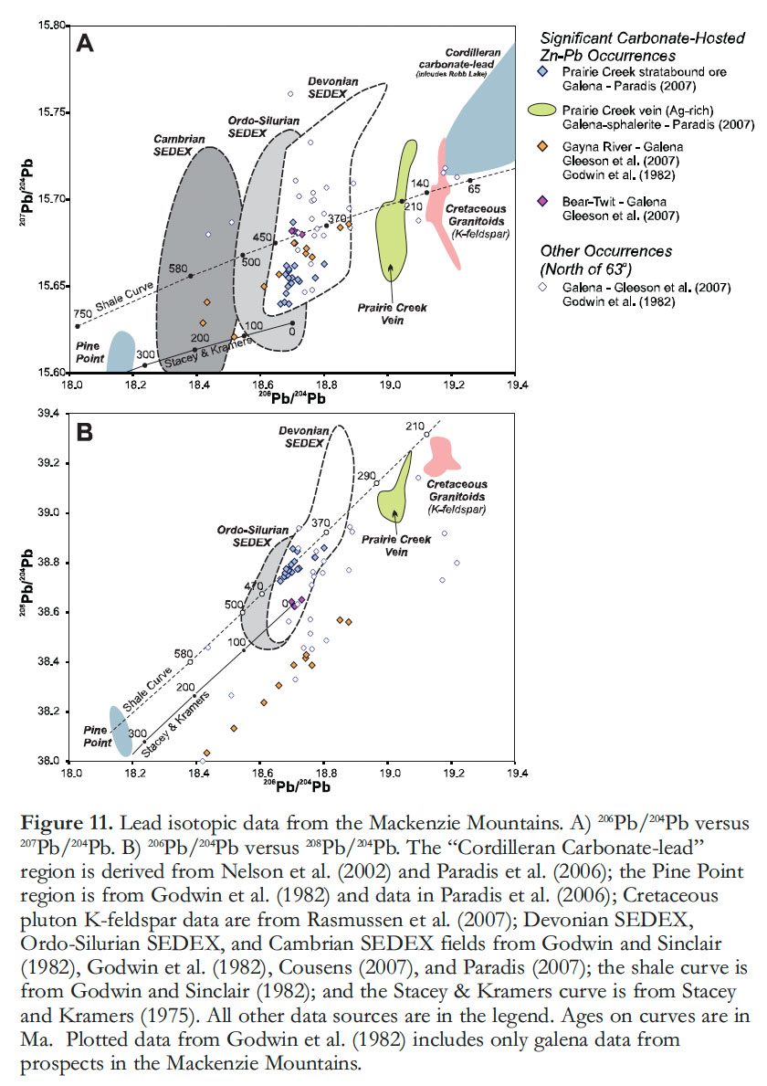
37 Radiogenic Pb isotope data from galena in a number of carbonate-hosted Zn–Pb occurrences shed some light on the evolution of these deposits when compared with the shale curve for SEDEX deposits (Fig. 11: Godwin et al. 1982; Godwin and Sinclair 1982; Morrow and Cumming 1982; Fraser 1996; Gleeson et al. 2007; Paradis 2007). The Pb isotopic data indicate a range of mineralizing styles. At Prairie Creek, the Pb isotopic data mimics lead from Silurian through Devonian SEDEX deposits (Fig. 11). Paradis (2007) used this to indicate that the stratabound deposits at Prairie Creek formed simultaneously with SEDEX deposits in the Selwyn Basin. The homogeneity is taken to infer either a similar fluid source, or significant mixing of Pb (Morrow and Cumming, 1982). Data in Morrow and Cumming (1982), Fraser (1996), and Paradis (2007) have been used to suggest that the Ag-bearing veins at Prairie Creek are related to Cretaceous deformation (referred to as the ‘Cadillac’ deposit), although the lead isotopic data collectively cross the shale curve suggesting a Triassic age (Fig. 11). In contrast, data from Gayna River (Gleeson et al. 2007) do not match either style of mineralization at Prairie Creek, and may represent the less radiogenic end-member on a mixing line with the more radiogenic, previously defined, “Cordilleran carbonate-lead” trend (Fig. 11A; Nelson et al. 2002; Paradis et al. 2006). Isotopic Pb data on galena from a variety of other prospects fall within the range of Gayna River or Prairie Creek data, or between them (Fig. 11A). The galena Pb isotopic data from the Wrigley–Lou prospects are too radiogenic to plot on Figure 11 (Heal 1976), but fall within the Cordilleran carbonate-lead trend. Notably, the signature from the Pine Point MVT deposit is significantly less radiogenic than that of lead from the carbonate-hosted Zn–Pb prospects in the MSM area, likely indicating distinct and separate mineralizing events, fluid pathways, and/or fluid sources (Fig. 11; Hannigan 2007).
38 Regional relationships and Pb isotopic data suggest that a minimum of two generations, but more likely three or four, of carbonate-hosted Zn–Pb (+ other base-metal) deposits are present in the MSM area. These include: (1) stratabound ore at Prairie Creek that is similar to, and possibly related to, the Cambrian–Mississippian SEDEX type in the Selwyn Basin to the west (Figs. 10 and 12); (2) vein and breccia-hosted Zn–Pb deposits, such as those at Gayna River and Bear–Twit, which may or may not be related to SEDEX mineralization (Figs. 10 and 12); (3) possible MVT deposits, and; (4) ca. 250 to 60 Ma, vein-hosted, Ag-Zn–Pb deposits, such as those at Prairie Creek (Figs. 10 and 12).
Intrusion-Related Deposits
39 At least 100 mineral occurrences in the study area have been shown to be directly related to intermediate to felsic, ca. 100 to 90 Ma (mid-Cretaceous) plutons and batholiths that are widespread throughout the northern Cordillera (Lang 2000; Selby et al. 2003; Hart et al. 2004a, b; Hart 2007; Rasmussen et al. 2007). In particular, tungsten skarn (e.g., Meinert et al. 2005) has historically been the most significant source of mining-generated revenue in this area (e.g., Dick and Hodgson 1982; Hart et al. 2004b). The plutons were emplaced in the Selwyn Basin area near a lithological transition to shallower-water platformal, sedimentary rocks (Mackenzie Platform; Fig. 13; e.g., Gordey and Anderson 1993); contiguous with a belt of plu-tons that extends from central Alaska through to British Columbia (Hart et al. 2004a, b; Hart 2007). These intrusions are mainly high-K, calc-alkaline to alkaline, biotite ± hornblende ± clinopyroxene ± muscovite-bearing granitoids comprising mainly granitic (senso stricto) to granodioritic compositions, with minor diorite to quartz diorite dykes. These are separated into four geographically, temporally, petro-logically, and metallogenically distinct suites. These subdivisions are the older Tay River suite (99–96 Ma), the Tungsten suite (98–96 Ma), the Mayo suite (97–93 Ma), and the Tombstone suite (93–89 Ma; Lang 2000; Hart et al. 2004a, b; Rasmussen et al. 2007, 2010). Most of the Tombstone suite intrusions, and many of the Mayo suite intrusions, follow an alkalic to subalkalic, monzonitic to monzogranitic compositional trend that contrasts with the dioritic-granodioritic-granitic trend exhibited by the majority of ‘mid’-Cretaceous plutons in the MSM area (Rasmussen et al. 2010). Regional geologic reconstructions (Nelson and Colpron 2007) and geochemical profiles (e.g., Lang 2000; Hart et al. 2004b; Rasmussen et al. 2007) indicate that the magmatism occurred in an area undergoing dextral transpression, with localized extension, hundreds of kilometres inboard of a post-collisional continental margin (Hart et al. 2004b; Rasmussen et al. 2010). The overall trend of the mid-Cretaceous plutonic belts is thought to parallel the North American Neoproterozoic rifted margin, the Paleozoic passive margin, and perhaps the transition from the Mackenzie Platform to the Selwyn Basin (Cecile et al. 1997; Hart et al. 2004b; Hart 2007). The distinctive metal budgets of each plutonic suite, as defined by Hart et al. (2004b) and Rasmussen et al. (2007) are interpreted to reflect their magmatic sources. Magmatic segregation and differentiation processes may have also played a role in the formation of tungsten skarns (Rasmussen et al. 2011).
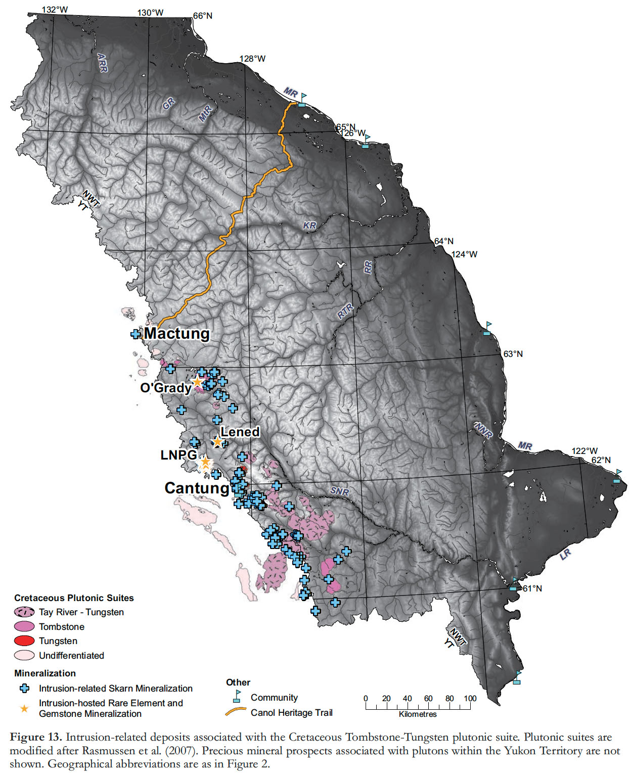 Display large image of Figure 13
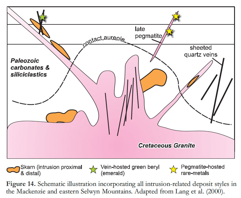
40 Intrusions in the MSM area belong to the Tay River suite and the southeast Tombstone–Tungsten belt (TTB) that comprises the Tungsten, Mayo, and Tombstone suites (Fig. 13; Lang 2000; Selby et al. 2003; Hart et al. 2004a, b; Rasmussen et al. 2007, 2010). The predominant forms of intrusion-related deposits associated with these plutonic rocks are divided into two broad categories (Figs. 13 and 14; Hart et al. 2004a, b). The first group consists of skarn-related deposits that are proximal to, and typically genetically related with, mainly the Tungsten suite and highly evolved phases of the Tay River suite. These skarns are mostly tungsten-rich (± minor Cu and/or Zn, Mo, Bi, and/or Au; Dick and Hodgson 1982; Bowman et al. 1985; Selby et al. 2003; Hart et al. 2004a, b; Rasmussen et al. 2007; Yuvan et al. 2007; Rasmussen et al. 2010), although Au-(Ag)-, or Sb-rich skarns are also associated with some Mayo and Tombstone suite intrusions. More distal base metal-rich deposits (e.g., Cu, Zn, Pb, Ag, Au) associated with all of the intrusive suites occur in the form of replacements or mantos and veins (Lang 2000; Hart et al. 2004a; Rasmussen et al. 2007). The second category of deposits associated with mid-Cretaceous plutons consists of pegmatite and quartz vein-hosted gemstones (emerald, Marshall et al. 2004; Tomb-stone suite-hosted, semi-precious tour-maline, Ercit et al. 2003). Pegmatite-hosted, rare-element deposits in the Little Nahanni Pegmatite Group (Li, Cs, Ta, Nb, and Sn; Figs. 13 and 14) are included here, although no direct link with the mid-Cretaceous plutons has been established and the pegmatites may be younger (Groat et al. 2003; Barnes et al. 2007).
 Display large image of Figure 14
Intrusion-Related Skarn Deposits
41 Currently and historically, the most economically important deposits in the study area are intrusion-related, tungsten-bearing skarns (± Cu, Zn, Mo, Au, Bi; Fig. 13; Dawson and Dick 1978; Dick and Hodgson 1982; Dawson 1996; Hart et al. 2004a). Two exemplary examples are: 1) The past-producing Cantung Mine; and 2) Mactung, North America’s second largest tungsten deposit; Sisson Brook, New Brunswick, is recognized as Canada’s largest tungsten deposit and its development will surpass Cantung as the largest tungsten producer in North America. Cantung has been an “on again/off again” producer of tungsten since the early 1960s and has an indicated resource of 2.9 million tonnes @ 1.2% WO3 (Table 1; http://www.natungsten.com). Mactung is currently in the feasibility stages and has an indicated resource of 33 million tonnes @ 0.88 WO3 (Table 1; http://www.natungsten.com).
42 The Cantung and Mactung deposits are both hosted in Lower Cambrian, calcareous strata proximal to small, slightly peraluminous, monzogranitic intrusions of the Tungsten suite (Dick and Hodgson 1982; Math-ieson and Clark 1984; Bowman et al. 1985; Gerstner et al. 1989; Selby et al. 2003; Hart et al. 2004a, b; Rasmussen et al. 2007, 2011; Yuvan et al. 2007). Scheelite is the most important tungsten mineral, accompanied by varying amounts of pyrrhotite, chalcopyrite, sphalerite, and molybdenite, and traces of bismuthinite and native bismuth (Fig. 5F; Rasmussen et al. 2011). The scheelite and pyrrhotite are most commonly components of the hydrous skarn facies (typically amphibole-rich, although biotite-rich varieties occur at Cantung). These minerals also occur less commonly in the anhydrous skarn facies (garnet–hedenbergite), and locally in high-grade tungsten deposits associated with coeval aplite dykes or late cross-cutting quartz–scheelite veins (Dick and Hodgson 1982; Bowman et al. 1985; Gerstner et al. 1989; Hart et al. 2004b; Rasmussen et al. 2011).
43 The ore-bearing skarn at Cantung Mine is adjacent to a medium-grained, weakly K-feldspar-phyric, biotite-bearing monzogranite stock that underlies the ore zones and has multiple phases of associated aplitic and, more rarely, pegmatitic dykes (Figs. 5F and 14; Rasmussen et al. 2011). Two types of ore are distinguished: 1) skarn dominated by a relatively pyrrhotite-poor anhydrous pyroxene-garnet assemblage in the ‘Open Pit’ orebody; this orebody is located on the surface about 300 metres above the roof of the underlying stock and is cut by high-grade, quartz–scheelite veins (Yuvan et al. 2007); and 2) anhydrous garnethedenbergite skarn, overprinted by a more pervasive and pyrrhotite-rich, hydrous, amphibole skarn facies and a less pervasive biotite ± pyrrhotite skarn in the underground E-Zone ore-body, located immediately above the roof of the underlying stock (Math-ieson and Clark 1984). Fluid inclusion and stable isotope data on the quartz– scheelite veins from the Open Pit ore-body indicate the ore was deposited at temperatures of 400–595°C and pressures of 2–4 kbar (about 6–10 km depth), from primary fluids of magmatic origin (up to 90 mol%), with only minor input from a country rock to meteoric source (Bowman et al. 1985; Yuvan et al. 2007). This is consistent with mineralogical, fluid inclusion, stable isotope, and biotite-apatite thermometry data from the underground ‘E-Zone’ biotite skarn that indicate mineralization occurred at T = 400 to 540°C and P = 2 to 3.8 kbar (greater than 6 km depth; Marshall et al. 2003). Yuvan et al. (2007) conclude that the high-grade quartz-scheelite veins are the distal expression of the mineralized skarn-forming event related to magmatism.
44 The Mactung deposit, which is hosted in limestone, can be divided into anhydrous (pyroxene–garnet) and hydrous (amphibole–biotite–pyrrhotite ± scheelite) skarn types (Dick and Hodgson 1982; Gerstner et al. 1989). This deposit is adjacent to a small, medium-grained, K-feldspar-phyric, biotite monzogranite with associated aplite and pegmatite dykes. Fluid-inclusion results from both skarn facies indicate that mineralization and anhydrous alteration began around 410–470°C and evolved to a hydrous skarn at 360–415°C, between 5 and 10 km depth (Gerstner et al. 1989). These conditions are similar to, although slightly cooler than, the estimates for Cantung.
45 Based on the criteria of Meinert et al. (2005), Cantung and Mactung can be considered reduced tungsten skarns (Bowman et al. 1985; Gerstner et al. 1989), which is consistent with the highly reduced nature of the inferred source of mineralizing fluids (e.g., the Tungsten plutonic suite; Hart et al. 2004b), a favourable condition for magmatic tungsten enrichment. This also could account for the paucity of gold associated with these intrusions, unlike the younger and more oxidized Tombstone suite that has been interpreted to have incorporated significant amounts of enriched, mantle-derived melt (Hart et al. 2004b). For this reason the Tungsten Suite is considered the most likely to contain tungsten skarn and associated ore in the study area (Rasmussen et al. 2007). The intrusion-related skarn deposits in the MSM area are coeval with other Cretaceous examples in the Cordillera, such as the Scheelite Dome deposit in the Yukon (Mair et al. 2006b), and the Northern Dancer/Logtung deposit in southern Yukon and northern British Columbia (Noble et al. 1984, 1986). Possible North American correlatives to Cantung and Mactung include tungsten skarn deposits associated with ca. 94 Ma quartz monzonite plutons in the western Sierra Nevada (e.g., the Pine Creek Mine; Newberry 1982; Brown et al. 1985). Other possible correlatives include ca. 95 to 90 Ma intrusions with associated pyrrhotite-rich, Cu-Au-bearing skarn deposits in the Carlin trend, Nevada (Groff et al. 1997).
Intrusion-hosted, Rare-Element and Gemstone Deposits
46 Other intrusion-related deposits in the MSM area (Figs. 13 and 14) include pegmatite-hosted, rare-element (Li, Cs, and Ta; e.g., Černý et al. 2005) showings and vein-hosted, semi-precious gemstones (beryl and tourmaline; Ercit et al. 2003; Marshall et al. 2004; Groat et al. 2007). Eighty kilometres north of Cantung, the Little Nahanni Pegmatite Group is a cluster of over 200, subparallel, up to two-metres-wide, pegmatite dykes exposed over an area of 5 by 11 km (Fig. 13; Groat et al. 2003; Barnes et al. 2007). U–Pb columbite dating indicates that the pegmatites crystallized at ca. 81 Ma (Mauthner et al. 1995), 15 m.y. younger than the age of recognized Cretaceous plutons in the region (Barnes et al. 2007; Rasmussen et al. 2007). The pegmatites are weakly deformed. K–Ar (mica) and 40Ar/39Ar (muscovite) ages indicate they were reheated at ca. 65 Ma (Mauthner et al. 1995; Barnes et al. 2007).
47 The pegmatites are divided into spodumene-bearing and spodumene-free varieties, the latter having more abundant lepidolite (Groat et al. 2003). Barnes et al. (2007) report up to 1.4% Li in the pegmatites, with the highest concentrations in spodumene-bearing varieties that have low Ta-Sn values. Cesium concentrations range from 46–497 ppm (up to 0.05% Cs) and Ta ranges from 5.3–188 ppm (up to 0.019% Ta; Barnes et al. 2007). Rare-element concentrations suggest that the pegmatites were derived from evolved crustal melts, similar to economically exploited pegmatites elsewhere (Černý et al. 2005; Barnes et al. 2007). The Little Nahanni Pegmatite Group fits the classification of Li–Cs–Ta pegmatites (Černý et al. 2005; Barnes et al. 2007) in that they are commonly hosted by metasedimentary rocks, rarely occur in their source granites, and are generally syn- to post-orogenic, filling fractures related to post-collisional stresses (Černý et al. 2005). This is consistent with the regional dynamic setting at ca. 80 Ma, in which localized extension was related to increased obliquity to NNE-oriented compression in a post-collisional setting (e.g., Hart et al. 2004a, b; Mair et al. 2006a; Rasmussen et al. 2007).
48 Semi-precious gemstones include green beryl (variety: emerald; Fig. 5E; Marshall et al. 2004; Groat et al. 2007) and elbaite tourmaline (Figs. 13 and 14; Ercit et al. 2003). Green beryl was discovered in 1997, 75 km northwest of Cantung, at the Lened skarn deposit (Fig. 13; Marshall et al. 2004). The Lened vanadium-rich beryl is hosted within quartz-carbonate veins that formed in conjunction with, although they cross-cut, a tungsten– copper mineralized pyroxene–garnet skarn (Marshall et al. 2004; Groat et al. 2007). The vanadium is interpreted to have been sourced from Devonian shales in the immediate footwall. Fluid inclusion and stable isotope data indicate that the fluids responsible for beryl formation were derived from the proximal, ca. 95 Ma felsic intrusion (Fig. 14; Marshall et al. 2004). A similar magmatic origin has been suggested by Groat et al. (2002) for emeralds at Regal Ridge, Yukon (now called Tsa da Glisza).
49 Semi-precious, Li–bearing gem tourmaline is hosted in lithium-rich, pegmatitic zones in the composite hornblende-bearing granitic to granodioritic of the ca. 92 Ma O’Grady batholith (Fig. 13; Gordey and Anderson 1993; Ercit et al. 2003; Rasmussen et al. 2007), interpreted to be part of the Tombstone Suite (Rasmussen et al. 2007). The gemmy tourmaline is in lithium-rich zones and exhibits pink, red, yellow-brown, and rare fluorine-rich green colors; outside these zones the tourmaline is black schorl–dravite (Ercit et al. 2003). The host pegmatites have a Nb–Y–F signature (Černý et al. 2005), in contrast to the Li–Cs–Ta signature of the previously discussed Little Nahanni Pegmatite Group (Ercit et al. 2003; Barnes et al. 2007), consistent with the composition of the metaluminous O’Grady pluton (i.e., hornblende-bearing, A-type pluton; Gordey and Anderson 1993; Ercit et al. 2003).
Other Deposit Types
Coal
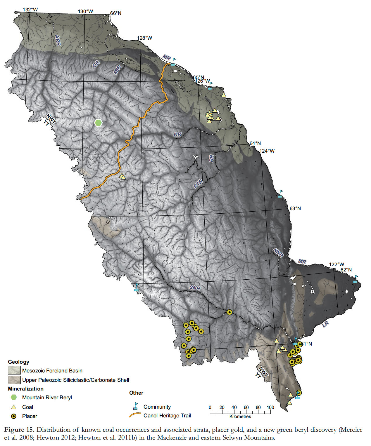
50 Coal is interbedded in the Carboniferous Mattson Formation in the southern Mackenzie Mountains (Figs. 3A and 15; Ricketts 1984; Potter et al. 1993; Cameron et al. 1994). The coal forms three seams with an average thickness of 1.5 m (Cameron et al. 1994) and is described as being sapropelic, high-bituminous, and inertiniteand liptinite-rich (Potter et al. 1993). The environment of deposition was a lagoonal setting in a prograding delta with little precipitation in an area of minimal tectonic activity (Potter et al. 1993; Cameron et al. 1994). Cameron et al. (1994) document a number of possible global analogues to the Carboniferous coal.
51 Cretaceous–Tertiary coal has been reported from the Mackenzie Mountains interior (Ricketts 1984; Martel et al. 2011), the southern Mackenzie Mountains (Ricketts 1984), north of the Mackenzie Mountains (Pyle and Jones 2009), and on the eastern edge of the Mackenzie Mountains, south of the community of Tulita (Fort Norman Coal Field; Fig. 15; Ricketts 1984; Dixon 1999; Tveten 2007). The coal within the Mackenzie Mountains (Fig. 15) forms thin seams (40–50 cm) in laterally discontinuous, steeply dipping, highly sheared, mud-stone-rich, post-Berriasian to Campanian strata (Martel et al. 2011). It is described as low-bituminous to semi-anthracitic (Martel et al. 2011) and, due to the sparse amount preserved, is considered non-economic. Sub-bituminous coal hosted by the Cretaceous Wapiti Formation in the very southernmost Mackenzie Mountains (Fig. 15), has an historical resource estimate of 240 million tonnes (Ricketts 1984). Coal deposits on the northern edge of the Mackenzie Mountains occur as <2 cm-thick seams in Albian strata (Pyle and Jones 2009).
 Display large image of Figure 15
52 Tertiary coal on the eastern edge of the Mackenzie Mountains and adjacent to the Mackenzie River (Fig. 15) is the most economically significant and is being examined for potential gasification. An historical resource estimate of 1.544 billion in-place tonnes of high-moisture, low-ash, 6500–8000 Btu/lb lignitic coal is reported, some of which is smoking as a result of spontaneous combustion (i.e., coal fires; Tveten 2007). Coal seams up to 6 m thick are reported, but the majority are 1–2 m thick, with ‘clean coal’ layers being slightly thinner. The coal seams are interbedded in a 200 m-thick succession of Tertiary shale, clay, siltstone, sand, and conglomerate related to allu-vial fan formation (see Tveten 2007).
Placer Gold
53 Minor amounts of placer gold have been reported in the very southwest and southeast of the Mackenzie Mountains (Fig. 15). These occurrences were investigated by Rasmussen et al. (2006), who recognized two styles of placer gold, based on geography and gold grain morphology; ‘Chuck’ and ‘isolated’ gold types. Both gold types are relatively pure, with fineness ([Au/Au+Ag]*1000) ranging from 700 to 975, in a wide range of grain morphologies. Using the Cailleux grain-flattening index, Rasmussen et al. (2006) show that both of these styles of placer gold were transported less than 10 km. They speculate that the gold source could either be intrusion-related, or yet undefined Carlin-type deposits. Both the recent discoveries of Carlin-type gold in the eastern Yukon, and the identification of gold grains in stream sediments in the Arctic Red River watershed to the north (Day et al. 2009) are encouraging that yet-unidentified gold deposits may be present in the Mackenzie Mountains.
Diamonds and Other Gemstones
54 Historical exploration for diamonds in the MSM area has generally focussed on Ordovician alkaline diatremes and associated volcanic rocks (Godwin and Price 1986; Goodfellow et al. 1995; Leslie 2009). Unfortunately, the diamond reports in Godwin and Price (1986) have not been reproducible. A discovery of green beryl (emerald) near the Mountain River in 2007 (Fig. 15; Mercier et al. 2008; Hewton et al. 2011a, b; Hewton 2012) has opened up the northern Mackenzie Mountains to the possibility of finding more emeralds. The beryl is hosted in extensional quartz–carbonate veins that cut Neoproterozoic sandstone, and yield a Re– Os pyrite crystallization age of ca. 345 Ma (Hewton 2012). Unlike the green beryl at Lened (Fig. 13) and Regal Ridge (Groat et al. 2002; Marshall et al. 2004) the Mountain River beryl cannot be linked to a Cretaceous pluton; the nearest pluton is about 85 km to the southwest and it appears unlikely that one exists in the subsurface (Figs. 13 and 15; Mercier et al. 2008; Hewton et al. 2011a, b; Hewton 2012). This beryl more closely resembles Columbian or schist-type (Hewton et al. 2011a, b; Hewton 2012), rather than the predominantly igneous-related emeralds at Lened and Regal Ridge (Groat et al. 2002; Marshall et al. 2004).
CONCLUSIONS
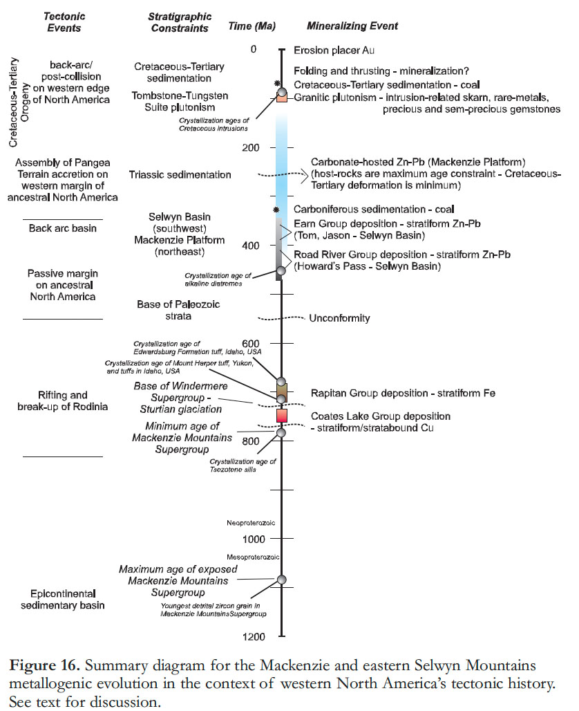
55 Many recent papers and publications have focused on the metallogenic evolution of distinct geological provinces, commodity-specific mineral deposit types, or mineral deposits related to particular geological events. The metal-logenic evolution of the MSM area of the Cordilleran orogen has been, as a whole, overlooked. We have used the Northern Minerals database (NORMIN; www.nwtgeoscience.ca), which hosts all publicly reported commodity occurrences in the Northwest Territories, to identify mineral prospects and deposits that were then evaluated as part of targeted field investigations (e.g., Dewing et al. 2006; Rasmussen et al. 2007; Mercier et al. 2008; Leslie 2009; Wallace 2009; Fernandes 2011; Hewton et al. 2011b) and regional bedrock investigations and mapping (e.g., Wright et al. 2007; Martel et al. 2011). Classification of the known mineral commodities in the database by mineral deposit types has established the predominance of five types and the limited presence of other, less economically significant commodities (Fig. 16). Each type formed as a result of distinct geologic events. The combination of temporal, geographic, stratigraphic, and tectonic controls delineates districts and outlines the metallogenic evolution of the region (Fig. 16).
 Display large image of Figure 16
56 The oldest recognized deposit type is the rift-related, Kupferschiefer-type Cu (±Ag) hosted by the <780 Ma Coates Lake Group (Fig. 16). Similarities with the African copper belt allow the speculation that there may be yet-unrecognized, large-tonnage deposits to be found in the MSM area. The <750 Ma glacial marine-related Rapitan Group unconformably overlies the Coates Lake Group and in the northwest hosts a massive stratiform iron deposit in the form of hematite-jasper, nodular iron formation with lesser banded iron formation, interpreted to have been deposited during continued rifting and Neoproterozoic glaciation (Fig. 16). During the Paleozoic evolution of the western margin of North America, a number of Zn–Pb SEDEX deposits formed during shale deposition in the Selwyn Basin; this includes the giant Howard’s Pass Zn district, which may be the world’s largest undeveloped zinc deposit. Also during the Paleozoic, and possibly extending into the Cenozoic and Mesozoic, the Mackenzie Platform was the locus of structurally-controlled carbonate-hosted Zn–Pb (+ other base-metals; Fig. 16), preserved as a diverse collection of mineral deposits and prospects. The mineralization styles and Pb isotopic data indicate three to four carbonate-hosted deposit types. The timing of carbonate-hosted Zn–Pb deposits is only broadly constrained and any regional correlations should be considered provisional. Finally, during the Cretaceous, in a distal, post-collision environment, melting of the mantle and lower crust resulted in the formation of the Tombstone–Tungsten Suite of granitoid plutons (Fig. 16). Associated with the Tungsten Suite plutons in the MSM area are intrusion-related tungsten skarn deposits, of which the Mactung and Cantung deposits are the largest tungsten deposits in North America. Some of the Cretaceous plu-tons also have semi-precious and precious gemstones, along with pegmatite-hosted rare-elements. Other deposits include Carboniferous and Cretaceous– Tertiary coal and minor modern placer gold occurrences (Fig. 16). The metal-logeny of the Mackenzie and eastern Selwyn Mountains has evolved over 700 million years, through a panoply of tectonic regimes, resulting in a diverse array of mineral deposits (Fig. 16), many of which may contain significant current and future natural resources.
Our ability to visit many of the deposits and prospects in the Mackenzie and eastern Selwyn Mountains was facilitated by the Sekwi Mountain Mapping project (NTGO–GSC), Peel Plateau and Plain project (NTGO– GSC–YGS), and the Nahanni MERA project (GSC–Parks Canada). Discussions with colleagues on these various operations, along with C. Jefferson and T. Hadlari have greatly enhanced our knowledge of the area. We are grateful to Canadian Zinc, Chevron Canada, North American Tungsten, Pacifica Resources (now Selwyn Chihong Mining Ltd.), and Phelps Dodge (now Freeport-McMoran) for access to their properties and we are indebted to Eagle Plains Resources, particularly R.J. Sharp working on their behalf, for collaboration, support, and enthusiasm regarding the region. Comments on a preliminary version of this manuscript by Dan Kontak, Scott Cairns, and David Watson helped improve aspects of this paper. Reviews by Charlie Jefferson and Maurice Colpron helped further clarify this contribution and we are grateful to Geoscience Canada Editor Brendan Murphy and Editorial Manager Cindy Murphy for their assistance. This is NWT Geoscience Office contribution #0046.