Geoscience Debate
Caribbean Geology:
Extended and Subsided Continental Crust Sharing History with Eastern North America, the Gulf of Mexico, the Yucatán Basin and Northern South America
doi:10.12789/geocanj.2013.40.001
THE PROBLEM
1 The geology of Middle America is complicated by its dispersal over many geographic elements (Fig. 1). Some are well studied (Gulf of Mexico and Colombia – Venezuela – Trinidad hydrocarbon provinces). Others remain poorly known because of lack of study, difficult access, tropical vegetation/weathering or large submarine extension. The area is largely submarine but there is no clear evidence of ‘oceanic spreading’ (ridges, magnetic anomalies) apart from the centre of the Cayman Trough. So, is the area composed of allochthonous oceanic crust or in situ continental crust, extended in place between the Americas?
THE PARADIGM
2 Popular understanding (e.g. Pindell and Kennan 2009) is that Jurassic oceanic Caribbean crust formed in the Pacific(Fig. 2). It thickened over a hotspot/mantle plume (Galapagos, or Sala y Gomez, or both; Révillon et al. 2000), or above a ‘slab gap’ as it overrode the Proto-Caribbean (Pindell and Kennan 2009) forming an ‘ocean plateau’ or large igneous province. Drifting eastwards relative to the Americas, it collided with a linear, west-facing intra-oceanic volcanic arc, reversing its subduction polarity and driving it between the Americas to collide progressively with North and South America during the Late Cretaceous – Eocene, dying in the process. The Lesser Antilles, formed in the Eocene after subduction jump from the Aves Ridge, are seen as the remnants of this arc. The Chortis and Maya blocks are seen to have rotated clockwise or anticlockwise by up to 180° from the Gulf of Mexico or southern Mexico.
ANALOGUES
3 The Caribbean Plate does not reveal classic oceanic spreading ridges or magnetic anomalies; except for the centre of the Cayman Trough (north – south anomalies; 300 km of Oligocene – Recent east – west spreading, 100 km north – south opening), the normal signature of oceanic origins is lacking. However, the Scotia Plate in the South Atlantic Ocean, and the Banda Sea Plate in Indonesia, which do carry ridges and identified magnetic stripes, are remarkably similar to the Caribbean and their geology is highly relevant (Fig. 10 in James 2005).
4 The Scotia and Banda Sea plates formed in place (Barker 2001; Honthaas et al. 1998). They lie, like the Caribbean Plate, between sinistrallyoffset, major continental blocks to the north and south. Each is around 3000 km long and 700–800 km wide. Each has a curved volcanic arc in the east. Northwest-trending volcanic arcs in the west follow the continental Sumatra/Java block on the western edge of the Banda region and the Chortís Block of the Caribbean Plate, while the Scotia Plate is bounded by the shallow (700 m), northwest-trending Shackle-ton Fracture Zone, built of continental slivers (Livermore et al. 2004), has active volcanoes in the Drake Passage. Fractures in the oceans east and west of the plates diverge towards them, indicating extension.
5 Magnetic data show that extension in the Scotia Plate distributed continental blocks that originally connected South America and Antarctica (Fig. 3; Barker 2001). The North and South Scotia ridges carry continental rocks and elevated parts of the Scotia Sea may be continental crust thinned by extension. The Neogene Banda Sea also opened in an extensional setting (Hall 1997). Dredged sedimentary and metamorphic rocks show that internal ridges are continental slivers.
6 Is there evidence that the Caribbean Plate carries continental crust? James (2009a) presented a comprehensive synthesis of data (regional tectonic fabric (Fig. 3), crustal thicknesses, gravity and magnetic data, stratigraphy, paleontology, highly silicic chemistry, ancient zircon grains in Cretaceous arc rocks) from the whole of Middle America; a separate article (James 2009b) interpreted these data. They all converge to show a regional history of continental extension during Jurassic–Cretaceous divergence of North and South America.
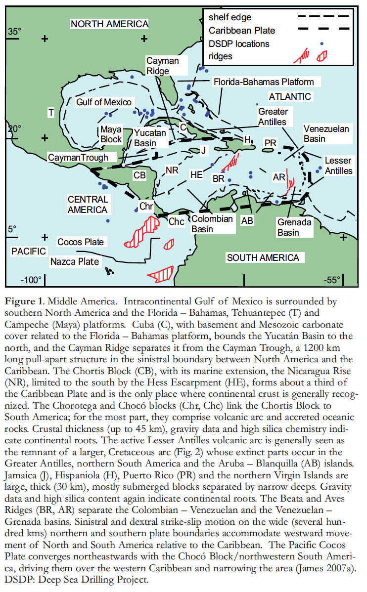 Display large image of Figure 1
TECTONIC SETTING AND FABRIC
7 As spreading occurred in the Central Atlantic, the westerly convex Mid-Atlantic Ridge moved away from Africa and extended N-S over Caribbean latitudes. The Caribbean Sea lies in an area of divergence between the central and northern South Atlantic (Figs. 3, 4, 5 in Fairhead and Wilson 2004; Figs. 3, 4B in Fairhead and Wilson 2005). Fracture patterns indicate that much of this extension took place in the Cretaceous and it is noteworthy that basalt extrusion occurred in the Caribbean at 120, 80–90 and 76 Ma.
EVOLUTION
8 Following development of the Central Atlantic Magmatic Province in the Late Triassic, extension resulted in sinistral offset of North America from South America along N60°W fractures/intra-continental faults, while the South Atlantic remained stable until the late Early Cretaceous. N 35° E Palaeozoic compressional structures along eastern North America (Appalachians), through Middle America (Cuba, Maya and Chortis blocks; Fig. 1) and into northern South America (Perijá, Maracaibo, Mérida, Espino grabens; Fig. 3) were reactivated as Triassic – early Jurassic rifts and dextral faults. N 60° E normal faults (e.g. Hess Escarpment; Fig. 1) and the Florida Arch formed and sinistral slip occurred along the northern Caribbean boundary. This early ‘Cayman’ displacement of around 600 km – the offset between the Maya and Chortis blocks recorded by their eastern margins and Jurassic grabens – did not affect the southern boundary. Rifting continued in the Jurassic – Cretaceous, evolving to (listric) fault block rotation accommodating wedges of continental red beds, marine source rocks and salt.
9 Subsidence of extended continental crust was matched by thick Cretaceous carbonate platform growth along eastern North America (up to 9 km in the Bahamas), around the Gulf of Mexico and in the Caribbean. Correlation of sections in the north of Cuba and Hispaniola with the Bahamas shows that these areas are in place, not allochthonous. Figure 4 shows the resultant geology of present-day off-shore North America farther north. It serves as a template for Caribbean geology, as indicated by seismic data, but here we have to add the Cretaceous basalt extrusions mentioned earlier.
10 Regional Late Cretaceous–Paleogene compression occurred around the Caribbean, culminating violently with Middle Eocene emplacement of major allochthons northward onto Cuba (e.g. 1000 km-long serpentinite sheets), and southward in Venezuela (the 250 x 25 x 5 km Villa de Cura volcanic complex). Regional occurrence of associated deposits (wildflysch) and of overlying Middle Eocene shallow marine carbonate units again demonstrates the internal coherence and autochthonous nature of Caribbean elements.
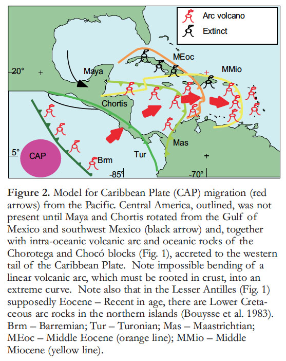 Display large image of Figure 2
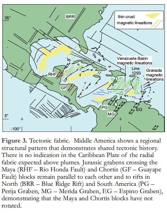 Display large image of Figure 3
11 In the late Eocene – Oligocene the Caribbean plate began east-west extension, with sinistral and dextral movement occurring along its northern and southern boundaries. This was a second sinistral event (the ‘Central Cayman’) on the northern boundary. It did not extend as far as the Pacific Plate and so the upper Cretaceous to Recent section in the Gulf of Tehuantepec is undisturbed. It resulted in some 300 km of east – west pull-apart extension between the Greater and Leeward Antillean islands. Sinistral and dextral displacement along the northern and southern Caribbean boundaries continues today, generating eastward-migrating uplift and complementary subsidence (spectacularly seen along northern Venezuela, where the -200 mgal gravity anomaly over the Maturín Basin, in the east, is the world’s largest negative anomaly at sea level).
12 In the southwestern Caribbean, convergence of the Pacific Chocó area drives northwestern South America and southern Central America to the northeast. The result is northward movement of the Panama arc and the Maracaibo Block over the southwest Caribbean, driving the South Caribbean Deformed Belt northwards. The +200 mgal gravity anomaly associated with the 5800m high Sierra Nevada de Santa Marta in northwest Colombia, the world’s highest elevation adjacent to sea floor (3000 m deep), demonstrates the dynamic nature of this area. Contrary to models of southward Caribbean subduction (there is no volcanism and GPS data show that the Caribbean Plate is moving eastward), the area is delaminating and moving over the Caribbean, which has continental composition (Ceron-Abril 2008). As mentioned above, Fairhead and Wilson (2004) used gravity, magnetic data and fractures to show that divergence occurs between the central and northern South Atlantic – there is no convergence over the Caribbean area.
THE CARIBBEAN ‘OCEANIC PLATEAU
13 The western part of the Venezuela Basin crust is up to 20 km thick and is generally interpreted as an ‘oceanic plateau’ or large igneous province. The Kerguelen, Iceland, Jan Mayen, Ontong Java, Rockall, and Seychelles ‘oceanic plateaus’ are known, from ancient zircon grains and dredged rocks, to be underpinned by continental crust (e.g. Foulger et al. 2005; Schaltegger et al. 2002).
14 Magnetic lineations over the area 1) trend northeast – southwest, 2) conform to regional tectonic fabric (Fig. 3), 3) reflect structure, not sea-floor spreading (Donnelly 1989; Diebold et al. 1999), and 4) extend the Triassic – Jurassic rift trends of North and South America. Seismic data show buried highs and ridges flanked by wedges of dipping reflections extending from 20 km to over 100 km. Pacific ‘oceanic’ models see these as volcanic flows and seamounts (Diebold et al. 1999).
15 Five Deep Sea Drilling Project holes have sampled the Caribbean ‘plateau’, terminating after a few metres in basalts or diorite sills dated 88–90 Ma (Saunders et al. 1973; Kerr et al. 2003). The basalt is vesicular and smooth with “morphology reminiscent of continental basalts” (Diebold et al. 1999); overlying sediments are shallow water in origin. The interpretation of Caribbean ‘plateau’ seismic data in the light of extended continental crust, such as seen offshore Europe and along eastern North America, appears in Figure 5 (James 2007b).
 Display large image of Figure 4
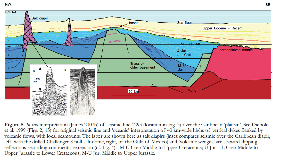 Display large image of Figure 5
THE STATE OF PLAY
16 Pacific models become ever more complex and numerous. There are at least six different models for opening of both the Grenada and Yucatán basins. There is disagreement over the existence and timing of the proposed Cretaceous arc polarity reversal and the number and polarity of Cretaceous arcs in the Caribbean. The presence of ancient zircon grains in Cretaceous arc rocks is explained by subduction of continental crust by the migrating/colliding arc and by (never illustrated) resurfacing in Cuba and along northern Venezuela. Blueschist is supposed to have formed in similar settings, yet it is interbedded with coeval sedimentary rocks in Cuba and Venezuela and is absent from the active subduction zones of the Lesser Antilles and Central America, in existence since at least the Early Cretaceous.
17 The new ‘Pirate’ model (Keppie 2013) proposed that the Caribbean has grown in the northwest and southwest by capturing microplates from northwest South America and the Gulf of Mexico. This model appears to regard the bulk of the Caribbean Plate to have formed in place (Fig. 4 in Keppie 2013) and so is a variant of the in situ model. The main debate remains ‘Pacific’ or ‘in situ’. As for ‘capture’ of northwest South America, Ceron-Abril (2008) showed how the area is delaminating and overriding the Caribbean continental crust. Jurassic rifts that parallel the regional tectonic fabric of Middle America deny rotation of the Chortis Block from the Gulf of Mexico.
THE POINT OF THIS PAPER
18 The main thrust of this article is to support the in situ, extended continental origin of the Caribbean Plate and to counter the ‘Pacific paradigm’. However, its lessons extend globally.
19 Many assumptions preface work in the oceans: “The ocean basins provide a unique opportunity to investigate magmatic processes and mantle composition. The absence of continental crust as a potential contaminant provides an untarnished sample of the deep Earth” (Saunders and Norry 1989). “Intra-oceanic arcs are important for geochemical studies of basalts because contamination by continent cannot have occurred” (Leat and Larter 2003).
20 Assumptions that continental crust is absent from the oceans are not justified. Many samples of continental rocks have been recovered from the oceans, such as those recovered by Woods Hole and the ODP (Ewing 1949; Ewing et al. 1948; Vasiliev and Yano 2007). The Lesser Antilles arc has continental thickness, produces rocks with silica content up to 76%, including quartz diorite and granite on La Désirade, and rounded quartz grains. Basalt compositions are directly comparable in chemical composition and mineralogy with those from continental margin orogenic belts (Lewis 1971). Seismic and gravity data show continental thicknesses and densities in the Central America arc, which produces high silica volcanic rocks and continental xenoliths. Original continental crust is present below both arcs. The northern Izu-Ogasawara ‘intra-oceanic island arc’ is underlain by continental crust (granite and andesite; Suyehiro et al. 1996). ‘Subduction factories’ of continental crust (Tatsumi and Kosigo 2003) and complex derivation of andesites (the ‘andesite problem’) from basalt (Takahashi et al. 2007) below ‘intra-oceanic arcs’ are not necessary.
ENDPOINT
21 While the Caribbean is held to have Pacific, oceanic origins, nobody will look for hydrocarbons there. The area lies between the prolific oil provinces of the Gulf of Mexico and northern South America. Oil occurrences/shows occur on surrounding islands and in Central America.
ACKNOWLEDGEMENTS
22 I am grateful for the invitation from Geoscience Canada to contribute to scientific debate on the origin of the Caribbean Plate. I thank Fraser Keppie and the editors for constructive comments.