Environmental Change in Garibaldi Provincial Park, Southern Coast Mountains, British Columbia
Johannes KochDepartment of Earth Sciences, Simon Fraser University, Burnaby, B.C., V5A 1S6
jkoch@sfu.ca
Brian Menounos
Geography Program, University of Northern British Columbia, Prince George, BC, V2N 4Z9
John J. Clague
Department of Earth Sciences, Simon Fraser University, Burnaby, B.C., V5A 1S6
Gerald D. Osborn
Department of Geology and Geophysics, University of Calgary, Calgary, AB, T2N 1N4
Accepted as revised 8 June 2004
SUMMARY
We are reconstructing Holocene environments in Garibaldi Provincial Park, in the southern Coast Mountains of British Columbia, by examining a diverse set of paleoenvironmental records, including tree-rings, lake sediments, glacial landforms, and photographs. This integrated study, in combination with previous research in adjacent areas, is providing a more detailed picture of past climate, vegetation, and glacier extent in Garibaldi Park than has heretofore been available. The data suggest recurrent, complex, and successively more extensive glacier advances during the last half of the Holocene, followed by dramatic warming, snow and ice loss, and a rise in treeline in the twentieth century. The multi-proxy approach used in this study is broadly applicable to other mountain areas. It yields more reliable and robust paleoenvironmental reconstructions than approaches based on only one or two types of data.RÉSUMÉ
Nous travaillons à reconstituer les conditions environnementales holocènes dans le parc provincial Garibaldi, dans la région sud des montagnes côtières de la Colombie-Britannique, en étudiant divers ensembles de variables représentatives du paléoenvironnement, dont les anneaux de croissance des arbres, les sédiments lacustres, les formes des paysages glaciaires, et des photographies. La présente étude synoptique, combinée aux résultats des recherches sur des régions adjacentes, nous fournit une image plus détaillée du climat, de la végétation et de l'étendue glaciaire d'alors dans le parc Garibaldi. Les données permettent de penser que durant la dernière moitié de l'Holocène, les avancées glaciaires ont été récurrentes, complexes et de plus en plus étendues. Par la suite, il y a eu réchauffement spectaculaire, déperdition de neige et glace, ainsi qu'une élévation de latitude de la limite forestière au cours du XXe siècle. L'approche par combinaisons de variables représentatives utilisées dans la présente recherche peut être employée tel quel pour l'étude d'autres régions montagneuses. Les reconstitutions paléo-environnementales sont plus fiables et plus sûres que celles reposant sur un ou deux types de données.
INTRODUCTION
1 The Kyoto Accord and recent droughts on the Canadian Prairies have heightened public interest in climate change. In many areas of the Northern Hemisphere, the 1990s were the warmest decade of the last century and, possibly, the last 1000 years (Fig. 1; Mann et al., 1998). Most climate scientists agree that this recent warming is anomalous, but debate continues about its source. Part of the difficulty in establishing the cause of warming on such short time scales is that Earth's climate system is complex, strongly nonlinear, and behaves in poorly understood ways. One way to improve our understanding of Earth's climate is to study its behaviour over long periods, ranging from centuries to millennia or more (Bradley and Jones, 1993).
Figure 1 Inferred changes in average annual temperature in the Northern Hemisphere over the last 1100 years based on tree-ring records. The reference line is mean annual temperature for the period 1961– 1990, averaged over land areas north of 20° The dashed line is the observed temperature record since the mid-19th century. Modified from Briffa and Osborn (2002).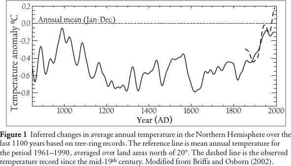
Display large image of Figure 1
2 Many biological and physical systems are sensitive to changes in temperature, precipitation, and other climate variables. Their careful study may provide a long-term perspective on climate change and its causes. Confidence in such proxies as faithful recorders of past climate is increased when a common climate signal can be obtained from several independent sources (Mann, 2002).
3 Alpine and subalpine environments are particularly sensitive to climate change. Many ecological and geomorphic processes in high mountains are influenced by changes in precipitation and temperature (Ryder, 1998; Luckman and Kavanagh, 2000). We are using a multi-proxy approach to reconstruct past precipitation and temperature in Garibaldi Provincial Park in the southern Coast Mountains north of Vancouver over the past several millennia. Garibaldi Park is an ideal location for this research because 60% of the area is above treeline, 21% is covered by snow and glacier ice, and its climate is controlled by both maritime and continental air masses. In addition, Garibaldi Park is near a major urban centre and is one of the most visited provincial parks in British Columbia.
4 In this paper, we briefly discuss previous paleoenvironmental research in the mountains of western Canada and present some of our findings from Garibaldi Park. The objectives of the paper are to 1) illustrate the main methods used in Holocene alpine environmental reconstruction in the Cordillera of western Canada, 2) show the power of multidisciplinary research in elucidating past environments, and3) summarize the history of late Holocene environmental change in the park.
5 Our research is partly driven by the premise that a better understanding of past climate change is important for forecasting future impacts of a warming climate. As glaciers in the southern Coast Mountains recede and, in some cases, disappear, the timing and magnitude of runoff may change significantly, affecting fish populations, power generation, and water supply. The disappearance of glaciers may also impact tourism as they are a major attraction for outdoor enthusiasts. Furthermore, changes in treeline can adversely impact some plants and wildlife that depend on open parkland.
CLIMATE CHANGE RESEARCH IN WESTERN CANADA
6 Researchers have used historical climate and observational data in conjunction with proxy climate records to reconstruct decadal- to centennial-scale fluctuations in climate over the last millennium (Fig. 1). The period that has received the most attention is the Little Ice Age, which began about AD 1200 and ended about AD 1900 (Grove, 2001; Luckman, 2004). Global surface air temperatures during the Little Ice Age may have averaged about 1°C lower than today, but fluctuated markedly over decadal and centennial timescales (Bradley and Jones, 1993). Most glaciers were more extensive during the Little Ice Age than at present. Those in the Canadian Rockies, for example, achieved their maximum extent of the last 10,000 years in the seventeenth to nineteenth centuries (Luckman, 2000).
7 Much of the research on Holocene glacier and climate fluctuations in western Canada has been done in the southern Canadian Rocky Mountains (see Luckman, 2000, for references). A variety of methods has been used to identify and date former glacier margins in the Rockies, including geomorphic analysis, stratigraphic and sedimentological observations, radiocarbon dating of fossil plants in glacial sediments, dendrochronology, and lichenometry. Changes in tree growth at high elevations and changes in sediment delivery to proglacial lakes have also been used to infer climate and glacier fluctuations during the Holocene (Leonard, 1997; Luckman, 2000).
8 Other mountain ranges in western Canada have been studied in far less detail than the Rockies, and much of that work has been done in the British Columbia Coast Mountains (e.g., Mathews, 1951; Brink, 1959; Ryder and Thomson, 1986; Ryder, 1987; Desloges and Ryder, 1990; Smith and Laroque, 1996; Smith and Desloges, 2000; Gedalof et al., 2002; Larocque and Smith, 2003; Clague etal., 2004). Most of these studies, however, utilize only one or two types of paleoenvironmental proxy data to detail past climate change. In this article, we use documentary, geomorphic, sedimentological, and biological evidence to more fully document paleoenvironmental change in one area of the Coast Mountains over the past several millennia.
STUDY AREA
9 Garibaldi Provincial Park is situated in the southern Coast Mountains, about 70 km north of Vancouver, British Columbia (Fig. 2). It was one of the first provincial parks established in the province, having been given park status in 1927 after several years of lobbying by recreational and environmental enthusiasts. There are more than 150 glaciers in Garibaldi Park, including two icefields larger than 10 km2 (Garibaldi Neve and Mamquam Icefield). Several peaks are more than 2500 m in elevation. Mount Garibaldi (2678 m asl) is only 20 km from tidewater at the head of Howe Sound.
10 The landscape of Garibaldi Park has been strongly shaped by Quaternary continental and alpine glaciation. Mount Garibaldi is a Quaternary volcano, and its present form is the product of an explosive eruption at the end of the last glaciation, about 13,000 years ago. At that time, the western half of the volcano erupted onto glacier ice filling nearby Cheakamus and Squamish valleys, and subsequently collapsed when the ice melted (Mathews, 1952).
11 The southwestern part of the park is strongly influenced by maritime air masses, but climate becomes increasing continental to the north and east. Overall, the climate is humid and cool, with very wet winters and dry summers. Annual precipitation ranges from 1000 to more than 3000 mm. More than 75% of the precipitation falls as snow between October and March.
12 Vegetation in Garibaldi Park is altitudinally zoned. A forest dominated by mountain hemlock and subalpine fir covers most areas between 1000 m and 1700 m asl (Brooke et al., 1970). At the upper limit of this zone, continuous forest gives way to parkland comprising islands of small, commonly stunted trees and subalpine meadows (Brooke et al., 1970).
PALEOENVIRONMENTAL PROXIES
13 Instrument records, photographs, and documents are the most reliable sources of information on past vegetation, ice cover, and climate in mountains. Photographs and maps are available for Garibaldi Park, but only for the last 90 years. Climate data for the park are limited, and climate data from adjacent areas only reach back to the late 19th century. Thus other means must be used to assess environmental change. Fortunately, Garibaldi Park contains many natural climate archives. One example is the park's forests. The widths and densities of annual rings in trees are partly controlled by climate, specifically temperature, precipitation, and snow cover. Furthermore, since tree rings can be resolved to the year, they afford opportunities to date glacier advances, for example where trees have been overridden by a glacier. Times of glacier advance and retreat can be less precisely determined by radiocarbon dating in situ and detrital wood in glacier forefields or glacial deposits, and by measuring lichens and soils on moraines and other glacial landforms (Luckman, 1998; Larocque and Smith, 2003). Proglacial lake sediments are another valuable climate proxy. Many proglacial lakes experience higher sedimentation during times of more extensive ice cover or rapid glacier retreat (Leonard, 1986, 1997; Menounos, 2002). Sediments in many proglacial lakes are varved (annually laminated) and thus offer the same temporal resolution as trees for paleoenvironmental studies. They also provide a continuous record of environmental change, unlike moraines and other glacial landforms, and that record may extend much farther back in time than living trees. A disadvantage of lake sediment records is that sedimentation in lakes can be influenced by factors not related to glacier fluctuations, for example landslides and floods. In addition, lags may exist between the production of sediment under glaciers and its delivery to lakes.
Glacier fluctuations
14 Glaciers in western North America advance or retreat in response to changes in winter accumulation and synoptic conditions during summer (e.g., Burbank, 1982; Bitz and Battisti, 1999; Moore and Demuth, 2001). The net mass balance of Sentinel Glacier in Garibaldi Park, for example, is positively correlated with winter precipitation (r2= 0.70) and negatively correlated (r2= -0.32) with summer temperature (Bitz and Battisti, 1999). Inter-annual to inter-decadal changes in winter accumulation in western North America are influenced by large-scale, ocean-atmospheric processes, including the El Niño-Southern Oscillation (ENSO) (Shabbar and Khandekar, 1996; Shabbar et al., 1997), and the Pacific Decadal Oscillation (PDO), an index of inter-annual to inter-decadal North Pacific sea surface temperature anomalies (Mantua and Hare, 2002). The PDO and ENSO exert their strongest control in the mountains of western North America during winter (Mantua and Hare, 2002).
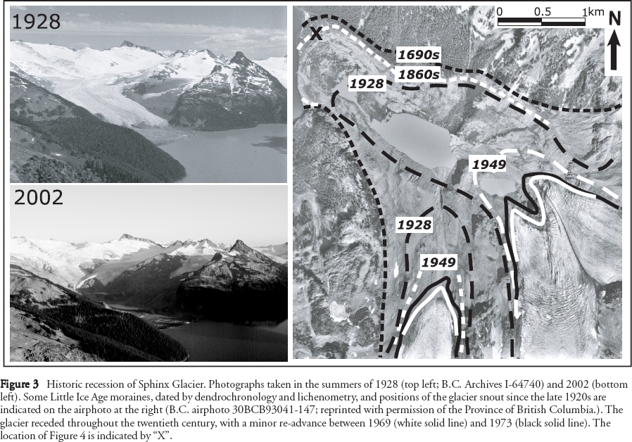
15 Glaciers that have a persistent positive net mass balance will adjust their areas, lengths, and thickness to accommodate the increased mass. They typically leave moraines and trimlines, delimiting their former extents long after they have receded. Conspicuous moraines and trimlines in Garibaldi Park delineate the maximum recent cover of ice during the Little Ice Age (Fig. 2, 3).
16 The time of the Little Ice Age maximum in Garibaldi Park may differ from glacier to glacier by as much as decades due to differences in glacier response times, but Figures 2 and 3 give a sense of the amount of ice loss in the park since the most extensive advance of the Little Ice Age in the early eighteenth century. At least 630 km² (33 %) of the park was covered by ice in the early eighteenth century. Ice cover today is 390 km², a loss of 38 % in less than 300 years (Koch et al., 2003a). Moraines dating to the late nineteenth century are very close to Little Ice Age maximum ice limits, thus most of the ice loss has happened in the last 150 years. In fact, much of the thinning and retreat date to the last 80 years (Fig. 3) and occurred during two intervals, one between about 1930 and 1960 and another starting in the late 1970s and continuing to the present. The two retreat phases were separated by a stillstand or minor re-advance of many glaciers in the late 1960s and early 1970s (Fig. 3). Glaciers in other parts of the Canadian Cordillera have fluctuated in a similar manner to those in Garibaldi Park since the late nineteenth century (e.g., Osborn and Luckman, 1988; Luckman, 2000).
Figure 2 Digital elevation model of Garibaldi Park and surrounding area. Study sites are labelled A-C and 1-9, the former being lake coring sites. Ice cover is shown at present (white areas) and at the maximum of the Little Ice Age (black areas).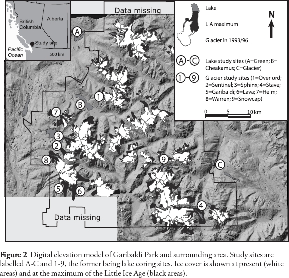
Display large image of Figure 2
Display large image of Figure 3
17 Ages of glacier advances can be estimated by dating plant remains in lateral and terminal moraines, or by determining the age of trees or lichens growing on the moraines (Fig. 4, 5;Luckman, 2000). Changes in tree growth may reveal the duration of an advance, as both react to the same forcing (Luckman, 2000). Cooler climate leads to glacier advance and, commonly, to narrow rings in temperature-sensitive trees (Luckman, 1996, 1998). Some tree species, for example mountain hemlock (Peterson and Peterson, 2001), may likewise form narrow rings during years when the snowpack is thick and lingers late into the summer.
18 The oldest tree on a moraine provides a minimum estimate for the time of moraine stabilization (Fig. 4; Lawrence, 1946). The tree ages need to be adjusted to account for the time between moraine stabilization and seedling germination ("ecesis"; McCarthy and Luckman, 1993; Winchester and Harrison, 2000). Photographic records and field studies indicate that the ecesis interval in Garibaldi Park is generally less than 20 years, but in some situations can be as long as 70 years (Koch, unpublished data).
Figure 4 Moraine crest in the forefield of Sphinx Glacier. Trees were cored to obtain a minimum date for construction of the moraine. The location of the photo is shown in Figure 3. View is to the southwest; the present-day glacier snout is about 2 km to the left.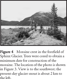
Display large image of Figure 4
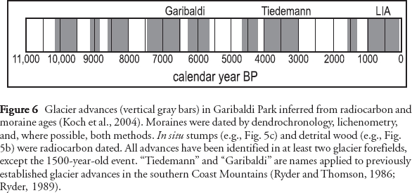
19 The age of a glacial advance can also be estimated by dating living trees damaged during the advance, dead trees in growth position overridden by the glacier (in situ stumps), and detrital wood within moraines or lying on the surface in the glacier forefield (Fig. 5; Luckman, 1998, and references therein). The most valuable ages are those derived from in situ trees, especially if the rings can be cross-dated into living chronologies to obtain the year when the tree was damaged or killed. Detrital wood and damaged and dead trees in growth position are present in the forefields of glaciers in Garibaldi Park, allowing us to acquire a more complete Holocene glacier record than has been possible in other parts of the Coast Mountains to date. Radiocarbon dating of these materials has revealed advances around 6000 and 3000 years ago and during the last 500 years (Fig. 6; Koch et al., 2004). Evidence for these events is provided by in situ stumps and detrital wood from several glaciers in Garibaldi Park. Other, more poorly constrained advances occurred about 8000 (Menounos et al., 2004), 4500, and 1500 years ago. The 8000- and 4500-year advances are inferred from detrital wood in the forefields of two glaciers in the park. Evidence for the 1500-year-old event has been found at only one glacier in the park, but has been documented elsewhere in the southern Coast Mountains (Reyes et al., 2004).
20 Late Little Ice Age moraines in Garibaldi Park have been dated more precisely by lichenometry and dendrochronology. Most glaciers achieved their maximum Little Ice Age extent in the late seventeenth or early eighteenth century (Koch et al., 2004).
Tree growth and climate
21 Alpine environments are ideal sites for dendroclimatic studies. Trees near treeline produce annual rings that vary in width and density in response to changing environmental conditions. Temperature and precipitation are the principal environmental factors affecting tree growth near treeline (Fritts, 1976; Schweingruber, 1996). Subalpine coniferous trees are particularly useful for reconstructing climate over the last millennium because they respond to changes in temperature and precipitation, yet can live for hundreds of years. Subalpine fir and mountain hemlock, for example, can attain ages of about 300 and 900 years, respectively.
Figure 5 Examples of damaged and killed trees in the forefields of glaciers in Garibaldi Park. a. Damaged tree (arrow in background) and killed tree (arrow in foreground) on the distal side of the outermost moraine of Warren Glacier. This moraine dates to AD 1705. b. Detrital wood (arrowed) at Sentinel Glacier. The wood yielded a radiocarbon age of 6040 ± 60 14C years BP (Beta-186508). c. Tree stumps in growth position in front of Sphinx Glacier. The trees were killed by the glacier 580 ± 70 14C years BP (Beta-186512). Glacier flow was right to left in (a) and (c), and left to right in (b).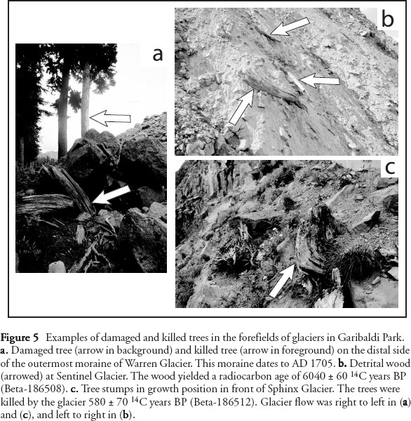
Display large image of Figure 5
Display large image of Figure 6
22 Ring-width chronologies of these species correlate positively with summer temperature and the PDO, and correlate negatively with winter precipitation, spring snowpack depth, and glacier mass balance (Lewis, 2001;Peterson and Peterson, 2001; Gedalof et al., 2002; Peterson et al., 2002). Mountain hemlock ring-width chronologies can also be correlated over much of the Pacific Northwest, including Garibaldi Park (Gedalof and Smith, 2001), which allows us to apply them in our study.
Lake sediments
23 Sediments in many lakes consist of distinctive annual couplets, termed varves. Varves yield valuable hydroclimatic information that cannot be obtained from other paleoenvironmental datasets. Flood events and seasonal hydrology, for example, can be inferred from detailed sedimentological analysis of varves (Menounos, 2002). The lower, coarser grained portion of a varve is deposited during late spring and early summer snowmelt. Other coarse layers may record severe rain-on-snow storms in the watershed, typically in summer or fall (Fig. 7). The basal, coarse layer of a varve is commonly overlain by microlaminated silt and clay, reflecting variable streamflow during summer. These sediments, in turn, are capped by clay deposited during winter when inflow to the lake is lowest and the lake is ice-covered.
24 Reconstructing hydroclimatic events from lake sediments is complicated by changes in sediment supply (Desloges and Gilbert, 1995), which result, for example, from fluctuations in glaciers (Leonard, 1997) or summer temperature (Leonard, 1986) on decadal and centennial timescales. Acquisition of varved sediment records from several lakes in a region can reveal the common hydrological signals contained in the records.
25 We have obtained and analyzed cores of varved sediments from Cheakamus, Green, and Glacier lakes (Fig. 2). Some of the conclusions that we have drawn from these records are 1) varve thickness is most highly correlated with the intensity of the annual flood during the period of streamflow monitoring; 2) varve thickness correlates with inter-annual changes in air temperature prior to the period of rapid glacier recession in the early twentieth century; and 3) temporal patterns of sedimentation are consistent with published records of glacial activity in the Canadian Cordillera and with our moraine chronologies based on tree rings and lichens. The lake sediment records suggest that ice cover was more extensive 3000 to 2500 years ago and between AD 1700 and 1920 than at present.
Treeline fluctuations
26 Changes in treeline provide important insights into past climate. Treeline is a dynamic boundary reflecting a balance between environmental conditions favouring and limiting tree growth (Arno and Hammerly, 1984). Temperature and the depth and duration of snowpack determine the location of treeline. Trees do not germinate successfully where the mean temperature of the warmest month is less than ca. 10°C (Arno and Hammerly, 1984). Thick snowpack and late-lying snow also determine vegetation distribution in the subalpine zone, as snow inhibits the successful germination of trees (Arno and Hammerly, 1984). Differences in aspect and local topography result in a variable vegetation cover near treeline, with islands of trees separated by meadows, an ecotone referred to as parkland. For this reason, the term "treeline" represents a transitional zone rather than an exact altitudinal line (Holtmeier, 1985).
27 Alpine treeline fluctuated throughout the Holocene, at all timescales and in all mountain ranges around the world (Rochefort et al., 1994; Kullman, 1995). Treeline was lowest during the final phase of the Little Ice Age in the nineteenth century. Since then, treeline has advanced upslope, reaching heights not attained for several centuries or even millennia (Kullman, 2001). Recent studies indicate that treeline is more sensitive to small changes in climate than previously thought and that paleotreeline identification may prove to be a useful tool for reconstructing past climate (Kullman, 1998). The Pacific Northwest shows great potential in this regard (Woodward et al., 1995; Rochefort and Peterson, 1996).
Figure 7 Portion of a core of varved lake sediments recovered from Glacier Lake, showing the relation between couplet thickness and stream inflow (approximated from the nearby Cheakamus River streamflow record). Each couplet comprises a thick layer of silt deposited during summer and a thin layer of clay deposited during fall and winter. Varve thickness is related to the magnitude of the annual flood and, over longer time scales, to changes in ice cover in the basin.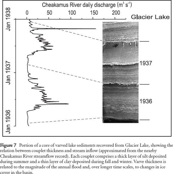
Display large image of Figure 7
28 Treeline in Garibaldi Park has not been disturbed by humans, and apparently has not been affected, at least over the last several hundred years, by large forest fires (Cashman, 2004) or insect outbreaks. Therefore, recent shifts in treeline can be attributed to changes in climate. We have determined the position of treeline at a few locations in Garibaldi Park in the twentieth century from photographic records dating back to the 1910s (Fig. 8). We have also sampled trees in areas with long photographic records to establish germination dates and growth rates (Koch et al., 2003b). Similar studies in the Canadian Rocky Mountains have provided important information on climate change (Luckman and Kavanagh, 2000) and for use in land management (Rhemtulla etal., 2002). Preliminary findings from our study indicate that treeline in some parts of Garibaldi Park has risen about 40 m over the last 100 years, and that many alpine meadows have been invaded by trees over this period (Koch et al., 2003b).
Figure 8 Photographs of the area west of Garibaldi Lake, taken in the summers of 1928 (top; B.C. Archives I-64739) and 2002 (bottom). Over this 74-year period, trees have invaded Black Tusk Meadows (left centre) and treeline has risen (left of Black Tusk).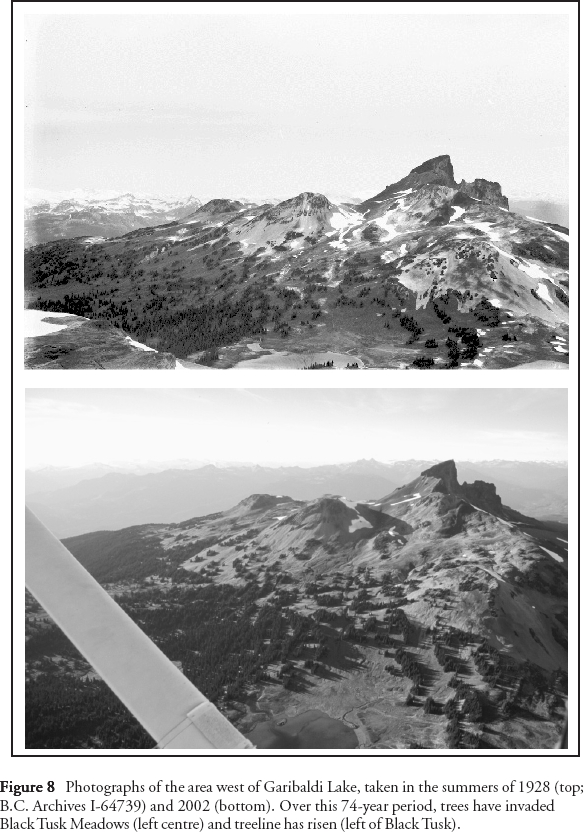
CONCLUSION
29 The climate of western Canada has fluctuated considerably since the last ice sheet disappeared from the region about 11,000 years ago. On the longest timescale, we see progressive cooling over the Holocene. Cooling was accompanied by successively more extensive advances of glaciers and was driven by a progressive decrease in summer solar insolation in the Northern Hemisphere (Luckman, 1993, 2000).
30 Long-term changes in solar insolation, however, cannot explain the shorter, decadal-scale changes in climate inferred from the geological and historical records, including those of the last century. Most of these shorter-term climate changes are driven by complex, poorly understood, ocean-atmosphere effects (Clark et al., 2002), by short-term changes in the total output of radiation from the Sun (Lean, 2002), by volcanism (Angell and Korshover,1985), or by some combination of these factors (Paul and Schulz, 2002). Environmental changes since the end of the Little Ice Age, however, suggest that the climate of the twentieth century was unusual in the context of the Holocene. The changes include average global surface warming of about 1°C (Bradley and Jones, 1993), recession of some glaciers from their most advanced positions of the last 10,000 years to positions they likely have not occupied in the last 8000 years (Koch et al., 2004), and concurrent upward migration of treeline from its lowest Holocene level to a level most likely not reached in the last 7000 years (Kullman, 2001). If this trend continues into the future, we may pass through a threshold from the present climate regime into a new, different one, with unexpected consequences for all of us.
ACKNOWLEDGEMENTS
We thank the British Columbia Mountaineering Club and its President Michael Feller for giving us access to their archive of historical photos of Garibaldi Provincial Park. We are also grateful to British Columbia Archives for access to the original glass negatives of the first geodetic survey of the park by A.J. Campbell, and to BC Parks and the rangers of Garibaldi Park, especially Chris Platz, for their support. Funding for the research was provided by the Natural Sciences and Engineering Research Council of Canada, Simon Fraser University, the University of British Columbia, and the Geological Society of America. B.H. Luckman and an anonymous reviewer provided valuable comments that improved the quality of the paper.REFERENCES
Angell, J.K. and Korshover, J., 1985, Surface temperature changes following the six major volcanic episodes between 1780 and 1980: Journal of Climate and Applied Meteorology, v. 24, p. 937-951.
Arno, S.F. and Hammerly, R.P., 1984, Timberline: Mountain and Arctic Forest Frontiers: The Mountaineers, Seattle, 304 p.
Bitz, C.M. and Battisti, D.S., 1999, Interannual to decadal variability in climate and the glacier mass balance in Washington, western Canada, and Alaska: Journal of Climate, v. 12, p. 3187-3196.
Bradley, R.S. and Jones P.D., 1993, ‘ Little Ice Age' summer temperature variations: Their nature and relevance to recent global warming trends: The Holocene, v. 3, p. 367-376.
Briffa, K.R. and Osborn, T.J., 2002, Blowing hot and cold: Science, v. 195, p. 2227-2228.
Brink, V.C., 1959, A directional change in the subalpine forest-heath ecotone in Garibaldi Park, British Columbia: Ecology, v. 40, p. 10-16.
Brooke, R.C., Peterson, E.B., and Krajina, V.J., 1970, The subalpine mountain hemlock zone: Ecology of Western North America,v. 2, p. 148-349.
Burbank, D.W., 1982, Correlations of climate, mass balances, and glacial fluctuations at Mount Rainier, Washington, USA, since 1850: Arctic and Alpine Research, v. 14,p. 137-148.
Cashman, B.H., 2004, New constraints on Holocene glaciation in western Garibaldi Provincial Park, British Columbia, Canada: M.S. thesis, Western Washington University, Bellingham, WA, 47 p.
Clague, J.J., Wohlfarth, B., Ayotte, J., Eriksson, M., Hutchinson, I., Mathewes, R.W., Walker, I.R., and Walker, L., 2004, Late Holocene environmental change at treeline in the northern Coast Mountains, British Columbia, Canada: Quaternary Science Reviews, in press.
Clark, P.U., Pisias, N.G., Stocker, T.F., and Weaver, A.J., 2002, The role of the thermohaline circulation in abrupt climate change: Nature, v. 415, p. 863-869.
Desloges, J.R. and Gilbert, R., 1995, The sedimentary record of Moose Lake: Implications for glacial activity in the Mount Robson area, British Columbia: Canadian Journal of Earth Sciences, v. 32,p. 65-78.
Desloges, J.R. and Ryder, J.M., 1990, Neoglacial history of the Coast Mountains near Bella Coola, British Columbia: Canadian Journal of Earth Sciences, v. 27,p. 281-290.
Fritts, H.C., 1976, Tree Rings and Climate: Academic Press, London, 567 p.
Gedalof, Z. and Smith, D.J., 2001, Dendroclimatic response of mountain hemlock (Tsuga mertensiana) in Pacific North America: Canadian Journal of Forest Research, v. 31, p. 322-332.
Gedalof, Z., Mantua, N.J. and Peterson, D.L., 2002, A multi-century perspective of variability in the Pacific Decadal Oscillation: New insights from tree rings and corals: Geophysical Research Letters, v. 29,p. 2204-2207.
Grove, J.M., 2001, The initiation of the "Little Ice Age" in regions round the North Atlantic: Climatic Change, v. 48, p. 53-82.
Holtmeier, F.-K., 1985, Die klimatische Waldgrenze – Linie oder Übergangssaum (Ökoton)? – Ein Diskussionsbeitrag unter besonderer Berücksichtigung der Waldgrenze in den mittleren und hohen Breiten der Nordhalbkugel: Erdkunde, v. 39,p. 271-285.
Koch, J., Clague, J.J., Smith, D.J. and Osborn, G.D., 2003a, Ice cover changes in Garibaldi Provincial Park, southern Coast Mountains, British Columbia, since the Little Ice Age: GAC-MAC-SEG Joint Annual Meeting, Vancouver, BC, Abstracts with Program (CD-ROM), v. 28, p. 78.
Koch, J., Clague, J.J., Smith, D.J. and Mathewes, R.W., 2003b, 20th century environmental change in the subalpine environment of Garibaldi Provincial Park, southern Coast Mountains, British Columbia: ACMLA, CAG, CCA, and CRSA Joint Annual Meeting, Victoria, BC, Abstracts, p. 49.
Koch, J., Osborn, G.D., Menounos, B. and Clague, J.J., 2004. Holocene glacier fluctuations in Garibaldi Provincial Park, southern Coast Mountains, British Columbia: GAC-MAC Joint Annual Meeting, St. Catharines, ON, Abstracts with Program (CD-ROM), v. 29, p. 355.
Kullman, L., 1995, Holocene tree-limit and climate history from the Scandes Mountains, Sweden: Ecology, v. 76,p. 2490-2502.
Kullman, L., 1998, Tree-limits and montane forests in the Swedish Scandes: Sensitive biomonitors of climate change and variability: Ambio, v. 27, p. 312-321.
Kullman, L., 2001, 20th century climate warming and tree-limit rise in the southern Scandes of Sweden: Ambio, v. 30, p. 72-80.
Larocque, S.J. and Smith, D.J., 2003, Little Ice Age glacial activity in the Mt. Waddington area, British Columbia Coast Mountains, Canada: Canadian Journal of Earth Sciences,v. 40, p. 1413-1436.
Lawrence, D.B., 1946, The technique of dating recent prehistoric glacial fluctuations from tree data: Mazama, v. 28, p. 57-59.
Lean, J., 2002, Solar forcing of climate change in recent millennia, in Wefer, G., Berger, W.H., Behre, K.-E., and Jansen, E., eds., Climate Development and History of the North Atlantic Realm: Springer, Berlin,p. 75-88.
Leonard, E.M., 1986, Use of lacustrine sedimentary sequences as indicators of Holocene glacial history, Banff National Park, Alberta, Canada: Quaternary Research, v. 26, p. 218-231.
Leonard, E.M., 1997. The relationship between glacial activity and sediment production: Evidence from a 4450-year varve record of Neoglacial sedimentation in Hector Lake, Alberta, Canada: Journal of Paleolimnology,v. 17, p. 319-330.
Lewis, D.H., 2001, Little Ice Age Investigations in Strathcona Provincial Park, Vancouver Island, B.C: M.Sc. thesis, University of Victoria, Victoria, BC, 148 p.
Luckman, B.H., 1993. Glacier fluctuation and tree-ring records for the last millennium in the Canadian Rockies: Quaternary Science Reviews, v. 12, p. 441-450.
Luckman, B.H., 1996, Dendrochronology at Peyto Glacier, Alberta, in Dean, J.S., Meko, D.S., and Swetnam, T.W., eds., Tree Rings, Environment and Humanity: Radiocarbon,p. 679-688.
Luckman, B.H., 1998, Dendroglaciologie dans les Rocheuses du Canada: Géographie physique et Quaternaire, v. 52, p. 137-149.
Luckman, B.H., 2000, Little Ice Age in the Canadian Rockies: Geomorphology, v. 32,p. 357-384.
Luckman, B.H., 2004, Neoglaciation, in Goudie, A. (ed.), Dictionary of Geomorphology: Routledge, London,p. 711-713.
Luckman B.H. and Kavanagh T.A., 2000, Impact of climate fluctuations on mountain environments in the Canadian Rockies: Ambio, v. 29, p. 371-380.
Mann, M.E., 2002, The value of multiple proxies: Science, v. 297, p. 1481-1482.
Mann, M.E., Bradley, R.S. and Hughes, M.K., 1998, Global-scale temperature patterns and climate forcing over the past six centuries: Nature, v. 392, p. 779-787.
Mantua, N.J. and Hare, S.R., 2002, The Pacific Decadal Oscillation: Journal of Oceanography, v. 58, p. 35-44.
Mathews, W.H., 1951, Historic and prehistoric fluctuations of alpine glaciers in the Mount Garibaldi map area, southwestern British Columbia: Journal of Geology, v. 59, p. 357-380.
Mathews, W.H., 1952, Mount Garibaldi, a supraglacial Pleistocene volcano in southwestern British Columbia: American Journal of Science, v. 250, p. 81-103.
McCarthy, D.P. and Luckman, B.H., 1993, Estimating ecesis for tree-ring dating of moraines: A comparative study from the Canadian Cordillera: Arctic and Alpine Research, v. 25, p. 63-68.
Menounos, B., Koch, J., Osborn, G., Clague, J.J. and Mazzucchi, D., 2004, Evidence for early Holocene glacier advance, Coast Mountains, British Columbia, Canada: Quaternary Science Reviews, v. 23,p. 1543-1550.
Menounos, B.P., 2002, Climate, fine-sediment transport linkages, Coast Mountains, British Columbia, Canada: Ph.D. thesis, University of British Columbia, Vancouver, BC, 244 p.
Moore, R.D. and Demuth, M.N., 2001, Mass balance and streamflow variability at Place Glacier, Canada, in relation to recent climate fluctuations: Hydrological Processes, v. 15, p. 3473-3486.
Osborn, G. and Luckman, B.H., 1988, Holocene glacier fluctuations in the Canadian Cordillera (Alberta and British Columbia): Quaternary Science Reviews,v. 7, p. 115-128.
Paul, A. and Schulz, M., 2002, Holocene climate variability on centennial-to-millennial time scales: 2. Internal and forced oscillations as possible causes, in Wefer, G., Berger, W.H., Behre, K.-E., and Jansen, E., eds., Climate Development and History of the North Atlantic Realm: Springer, Berlin,p. 55-73.
Peterson, D.W. and Peterson, D.L., 2001, Mountain hemlock growth responds to climatic variability at annual and decadal time scales: Ecology, v. 82, p. 3330-3345.
Peterson, D.W., Peterson, D.L. and Ettl, G.J., 2002, Growth responses of subalpine fir to climatic variability in the Pacific Northwest: Canadian Journal of Forest Research, v. 32,p. 1503-1517.
Reyes, A.V., Smith, D.J., Clague, J.J., Allen, S.M. and Larocque, S.J., 2004, The Bridge Advance: a pre-Little Ice Age advance of alpine glaciers in the Coast Mountains of British Columbia, Canada: GAC-MAC Joint Annual Meeting, St. Catharines, ON, Abstracts with Program (CD-ROM), v. 29,p. 354.
Rhemtulla, J.M., Hall, R.J., Higgs, E.S. and Macdonald, S.E., 2002, Eighty years of change: Vegetation in the montane ecoregion of Jasper National Park, Alberta, Canada: Canadian Journal of Forest Research, v. 32, p. 2010-2021.
Rochefort, R.M. and Peterson, D.L., 1996, Temporal and spatial distribution of trees in subalpine meadows of Mount Rainier National Park, Washington, U.S.A.: Arctic and Alpine Research, v. 28, p. 52-59.
Rochefort, R.M., Little, R.L., Woodward, A. and Peterson, D.L., 1994, Changes in subalpine tree distribution in western North America: A review of climate and other factors: The Holocene, v. 4, p. 89-100.
Ryder, J.M., 1987, Neoglacial history of the Stikine-Iskut area, northern Coast Mountains, British Columbia: Canadian Journal of Earth Sciences, v. 24, p. 1294-1301.
Ryder, J.M., 1989, Holocene glacier fluctuations, in Fulton, R.J., ed., Quaternary Geology of Canada and Greenland: Geological Survey of Canada, Geology of Canada, no. 1, p. 74-75 (also Geological Society of America, The Geology of North America, v. K-1).
Ryder, J.M., 1998, Geomorphological Processes in the Alpine Areas of Canada: Geological Survey of Canada, Bulletin 524, 44 p.
Ryder, J.M. and Thomson, B., 1986, Neoglaciation in the southern Coast Mountains of British Columbia: Chronology prior to the late Neoglacial maximum: Canadian Journal of Earth Sciences, v. 23, p. 273-287.
Schweingruber, F.H., 1996, Tree Rings and Environment. Dendroecology: Haupt, Berne, 609 p.
Shabbar, A. and Khandekar, M., 1996, The impact of El Niño-Southern Oscillation on the temperature field over Canada: Atmosphere-Ocean, v. 34, p. 401-416.
Shabbar, A., Bonsal, B., and Khandekar, M., 1997, Canadian precipitation patterns associated with the southern oscillation: Journal of Climate, v.10, p. 3016-3027.
Smith, D.J. and Desloges, J.R., 2000, Little Ice Age history of Tzeetsaytsul Glacier, Tweedsmuir Provincial Park, British Columbia: Géographie physique et Quaternaire, v. 54, p. 131-137.
Smith, D.J. and Laroque, C.P., 1996, Dendroglaciological dating of a Little Ice Age glacial advance at Moving Glacier, Vancouver Island, British Columbia: Géographie physique et Quaternaire, v. 50,p. 47-55.
Winchester, V. and Harrison, S., 2000, Dendrochronology and lichenometry: colonization, growth rates and dating of geomorphological events on the east side of the North Patagonian Icefield, Chile: Geomorphology, v. 34, p. 181-194.
Woodward, A., Schreiner, E.G. and Silsbee, D.G., 1995, Climate, geography and tree establishment in subalpine meadows of the Olympic Mountains, Washington, U.S.A.: Arctic and Alpine Research, v. 27, p. 217-225.