Great Mining Camps of Canada 1.
The History and Geology of the Keno Hill Silver Camp, Yukon Territory
R. J. (Bob) Cathro3230 Dogwood Road, Chemainus, BC, V0R 1K2, Canada
bobcat62@telus.net
Submitted, 15 March 2006; accepted as revised, 21 August 2006. Note added in proof: The publishers and authors gratefully acknowledge the financial contribution of the Yukon Geological Survey in presenting our colour images for this article.
SUMMARY
The Keno Hill Camp was one of The Great Mining Camps of Canada; it was not only Canada's second largest primary silver producer and one of the richest Ag-Pb-Zn vein deposits ever mined in the world, it was also one of the mainstays of the Yukon economy from the 1920s, after the rapid decline of the Klondike Goldfield, until the early 1960s. At its peak in the 1950s and early 1960s, it supported about 15% of the territorial population. It also produced more wealth than the Klondike, one of the richest placer gold districts in the world. Following a small amount of hand mining between 1913 and 1917, larger scale production was almost continuous from 1919 to 1989, except during the war from 1942 to 1945. Two companies produced most of the ore, Treadwell Yukon Corp. Ltd. from 1925 to 1941, and United Keno Hill Mines Ltd. between 1947 and 1989. Both companies went bankrupt when silver prices failed to increase as quickly as mining costs. About three years of uneconomic ‘reserves' remained at closure.SOMMAIRE
Le camp minier de Keno Hill est l'un des principaux camps miniers du Canada. Non seulement s'agit-il du deuxième plus grand producteur canadien de minerai primaire d'argent et l'un des plus riches gisements filoniens de Ag-Pb-Zn exploité du monde, mais il a été aussi l'un des piliers économiques du Yukon à partir des années 1920, après le rapide déclin des champs aurifères du Klondike, jusqu'au début des années 1960. Au faîte de sa production, dans les années 1950 et début 1960, il fournissait du travail à environ 15% de la population du Yukon. De plus, il a créé plus de richesse que l'or du Klondike - l'un des plus riches districts d'or placérien au monde. Après une courte période d'extraction artisanale, de 1913 à 1917, a suivi une période d'extraction à plus grande échelle, presque continue, entre 1919 et 1989, sauf durant la guerre, entre 1942 et 1945. Deux sociétés minières ont assuré l'extraction de la presque totalité du minerai, soit la Treadwell Yukon Corp. Ltd., de 1925 à 1941, et la United Keno Hill Mines Ltd., de 1947 à 1989. Ces deux sociétés ont failli financièrement alors que le prix de l'argent a été surpassé par les coûts d'extraction. À la fermeture, le volume des réserves équivalait à environ trois années d'exploitation.
INTRODUCTION
1 Considerable research into mining geology and ore controls, along with systematic surface exploration, was conducted in the Keno Hill silver camp (hereafter referred to as the Keno Hill Camp) during the last 45 years of operation. Several geologists even held the title of Research Geologist. However, publication was not encouraged by United Keno Hill Mines Ltd. (UKHM) and little detailed information has been published on the subject since Boyle (1965), whose fieldwork dates from 1953 to 1955. Much of the accumulated geological wisdom and corporate memory is summarized for the first time in this paper, which is a synthesis of the observations made over the years by many mine and exploration geologists. The emphasis is on mining geology and how its ‘twists and turns' shaped the history of the camp.
2 Although most of the production and grades and geographic information were first reported in Imperial units, they have been converted to metric units throughout this paper. The only exception is Ag prices, which have always been quoted on world markets in $US/troy ounce (oz/ton). For simplicity, Ag assays and production figures are given in both Imperial and metric units. Although Ag grades are normally reported in the metric system as g/t, Keno Hill ore is so rich that they are given in kg/t throughout this report. To avoid confusion, ‘t' refers to tonne and the short ton is always spelled out. Also, mine levels (e.g. 650 level), which were named according to their approximate vertical distance in feet below the discovery showing, remain unchanged.
Location and Access
3 The camp is located close to the geographic centre of the Yukon Territory, at latitude 63°55'N and longitude 135°23'W, within NTS map-sheets 105 M/13, 14, and 15 (Figs. 1, 2). It is accessible by a 460 km road north from Whitehorse. The final 55 km is from Mayo, which is the nearest large town and a regional transportation and administrative centre. Mayo is situated on the Stewart River, one of the main tributaries of the Yukon River (Figs. 1, 2). The Keno Hill Camp is about 300 km south of the Arctic Circle and 80 km south of the height of land that separates the Yukon and Mackenzie River watersheds. North-facing slopes are without sunshine for 10 weeks every winter. Recorded temperatures at Mayo range from -63° to +35°C (-82° to +95°F), and annual precipitation averages about 28 cm, half of which falls as snow. July is the wettest month. One of the most pleasant climatic features is the periodic appearance of warm ‘Chinook' winds, similar to those that affect Calgary, which blow across from the Pacific coast during winter and suddenly raise the temperatures dramatically.
4 Yukon Territory remained relatively isolated until the Alaska Highway was built (for military purposes) in the early 1940s. The Keno Hill Camp was connected to the Alaska Highway at Whitehorse by an all-weather highway in the 1950s. Prior to that, freight and passenger service to Mayo was only available on sternwheel steamboats in summer and horse-drawn sleighs in winter. Air service to Mayo began about 1933 and passenger service became available to Edmonton by 1937.
5 Soon after the 1898 Klondike Gold Rush, there were over 200 boats of all sizes on the Yukon River system; in fact, it had more riverboats than any North American river except the Mississippi. The 700 km trip from Whitehorse to Dawson required two days for the downstream leg, travelling with the 6 knot current, and four days for the return voyage. The boats carried up to 100 passengers and 270 t of freight, some of which was pushed in front on barges. They were built with a draft of only 1.2 m so as to avoid the shifting sandbars. The quantity of wood fuel consumed by the boats was astounding, 25 cords on the downstream leg and 75 cords on the return trip. Each boat burned about 8,000 cords per season. Slightly smaller sternwheelers were used on the 270 km voyage that connected Mayo to the Yukon River. The river distance from Mayo to Whitehorse is about 860 km. Without this established river transportation system, development of the Keno Hill Camp would have been delayed for decades.
6 The ore was transported from Whitehorse to the seaport of Skagway, Alaska, on the White Pass and Yukon Railway, the nce to Vancouver or U.S. destinations by sea-going ships and finally by rail to a U.S. smelter. In the early years, the ore had to be handled as many as 10 times between the stope and the smelter.
Figure 1. a) Location map showing the relative positions of Figure 2 and the Keno Hill Camp; b) Detailed location map showing specific topographic features near the Keno Hill Camp.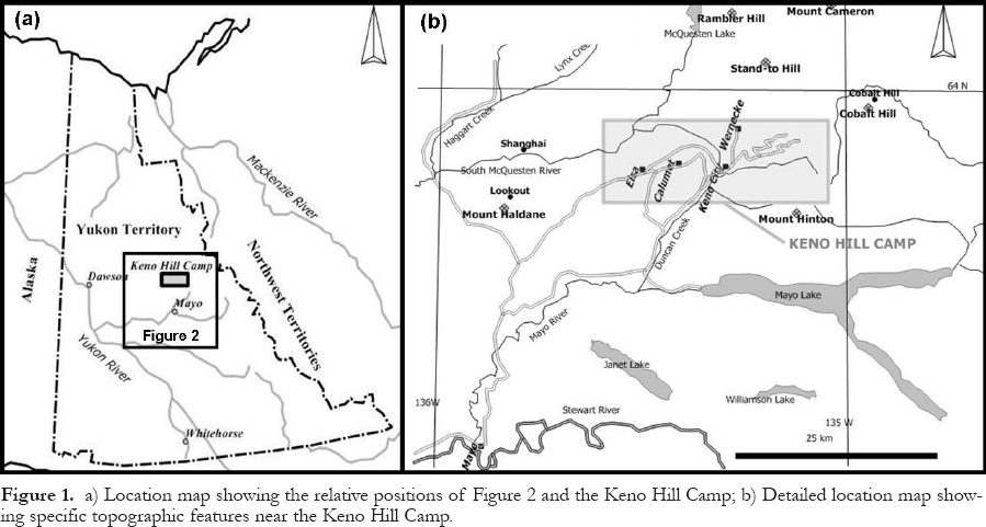
Camp Definition
7 ‘Camp' is a term that is used to describe a cluster of deposits and occurrences that have a similar mineralogy and geological setting. The Keno Hill Camp is defined herein as a belt approximately 21 km long and 2 to 6.5 km wide that crosses parts of Galena, Keno and Sourdough Hills (Fig. 2). It extends from the Silver King mine (#2) at the west end, to the Caribou Hill mine (#37) at the east end (Fig. 3). The camp was named Keno Hill because the earliest large-scale mining took place there, even though most of the silver was actually produced from mines situated on Galena Hill.
8 The camp contains 16 ‘important' deposits, defined as those that produced over 15.55 t (500,000 oz) of Ag, another 19 that shipped smaller amounts to a smelter, and 35 minor occurrences. The deposits with recorded production are listed in Table 1. Two of the small producers in Table 1, Lookout and Cobalt Hill, lie outside the camp and are shown on Figure 1b.
Camp Overview
9 Camp Overview The camp is part of a larger Ag and Pb district that stretches 100 km northeast from Mount Haldane (Lookout Mountain) along the northern edge of the South McQuesten Valley, across the camp as defined above, and includes the eastern end of Keno Hill and Cobalt for additional references in the extensive government bibliography.
10 Hill, as well as three locations in the Davidson Range (Stand-to Hill, Rambler Hill and Mount Cameron; Fig. 1b). Scattered mineralization in the outlying parts of the district is similar to that within the camp, and several small occurrences received physical exploration and even shipped small amounts of ore, but no deposit was large enough to warrant further work.
11 In most parts of the world, these hills would be called mountains. Local relief ranges from the 525 m elevation at the South McQuesten River to 1975 m at the summit of Keno Hill. The topography is characterized by moderate to gentle slopes and extensive vegetation cover. Less than 5% of the hard resistant units, which are the most favourable host rocks to the silver deposits, form outcrops. The summit of Galena Hill is a long flat ridge at an elevation of about 1475 m. The only steep parts of the camp are the north sides of Keno and Sourdough hills. Permafrost extended to depths of about 80 m on the north side of the hills when mining commenced.
Information Sources
12 Information on mining geology is derived mainly from published and unpublished company files and personal recollections provided by former mine geologists. The main sources for regional geology are published reports of the Geological Survey of Canada (GSC) and various Territorial government surveys. Selected references are included at the end of this paper.
13 Four excellent books have been produced on the general history of the Mayo district in the last few years, starting with Gold and Galena (MacDonald and Bleiler 1990), which relied heavily on Aho (1972). The others, all lavishly illustrated in full colour, are K-L Services (2004), Aho (2006), which is an edited version of Aho (1972), and Bleiler et al. (2006). The latter contains a coloured geological map of the district, a simplified version of which is used in this paper (Fig. 2). Both the MacDonald and Bleiler(1990) and Aho (2006) bookscontain detailed information about the pioneers.
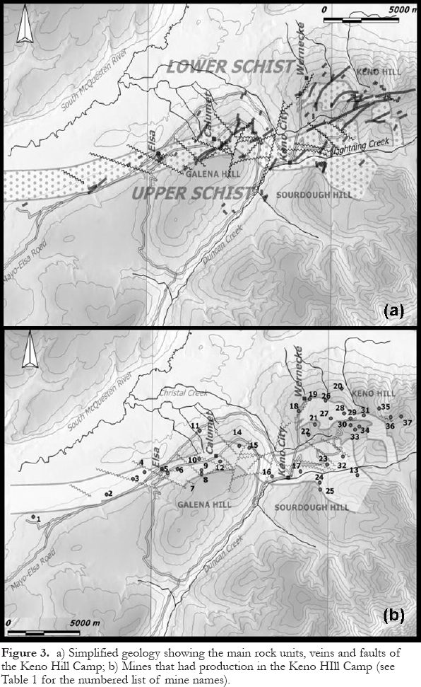
Figure 2. Simplified geological map of the Mayo district and surrounding area, including the Keno Hill Camp, by Charlie Roots for the Yukon Geological Survey (modified from similar figures in Bleiler et al. 2006 and Lebarge et al. 2002). (Additional cartography work by D. Leonard of Newfoundland and Labrador Geological Survey.)Figure 3. a) Simplified geology showing the main rock units, veins and faults of the Keno Hill Camp; b) Mines that had production in the Keno HIll Camp (see Table 1 for the numbered list of mine names).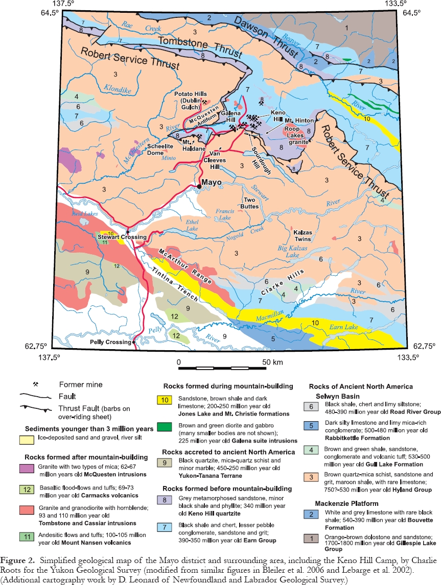
GEOLOGICAL SETTING
Regional Geology
14 A great deal of information has been published on this subject by the GSC, as well as the Yukon Geological Survey and its predecessors. A full treatment of this complex topic is beyond the scope of this paper, and the reader is referred to Boyle (1965), Murphy (1997), Roots and Murphy (1992), and Mair et al. (2006)
15
Table 1. Keno Hill Camp. Total recorded production - 1913 to 1990 (listed in order of decreasing Ag ounces)
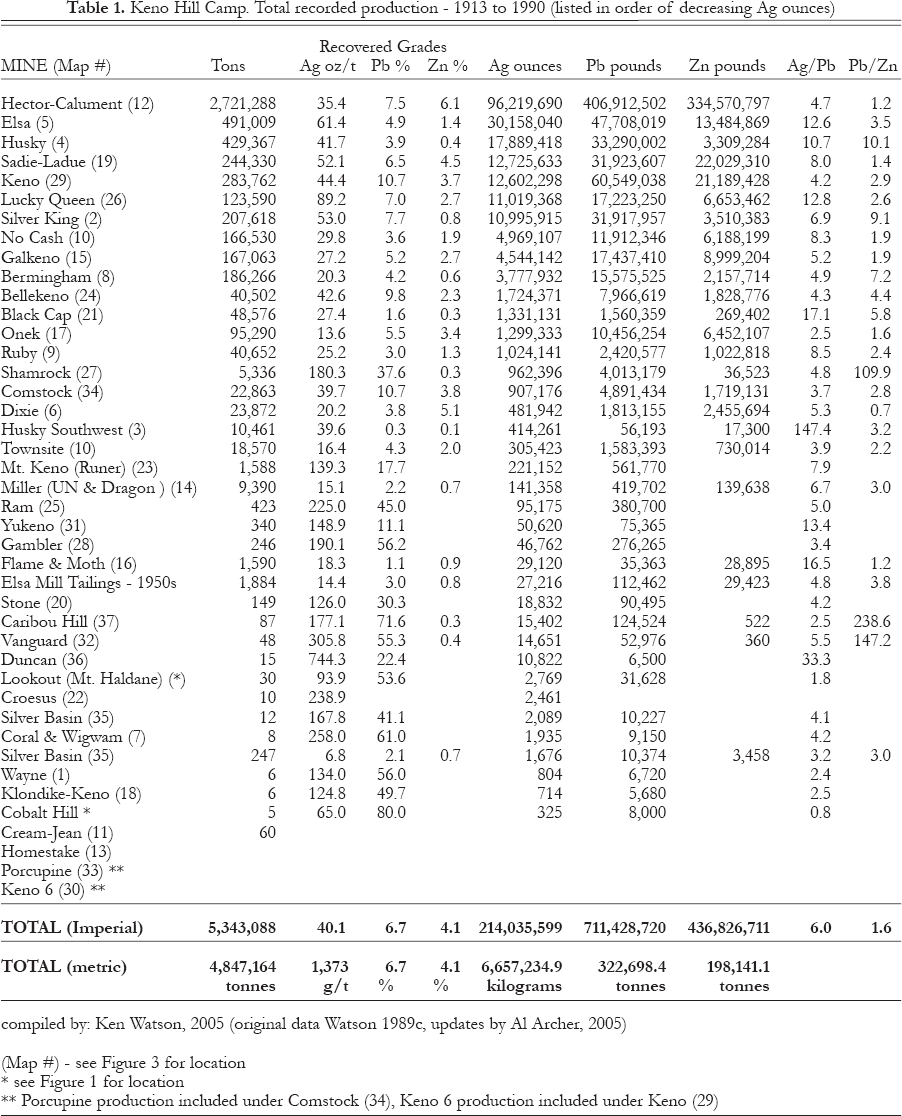
Display large image of Table 1
16 Fingler (2005) has summarized the regional geology of Murphy (1997) as follows:
17 "The region is located within the western part of the Selwyn Basin. The stratigraphy consists of deformed and metamorphosed basinal sediments that accumulated at the edge of the Neoproterozoic to Paleozoic continental margin. During the Jurassic to Cretaceous periods (160 to 130 Ma), these rocks were subjected to compressional orogenesis related to large-scale plate convergence. This shortening episode also caused ductile, north-south directed thrusting, which generated three main thrust panels containing highly strained to transposed basin strata. In the Mayo-McQuesten district, the panels are separated by the Robert Service and Tombstone thrust faults.
18 Between 90 and 95 million years ago (Ma), a tectonic change from convergent-oblique to subduction-dextral strike-slip movement resulted in an episode of magmatism and the emplacement of the Tombstone series of intermediate to felsic plutons. About 65 Ma, renewed compressional tectonics that formed the Mackenzie Mountains induced another magmatic event and the emplacement of the McQuesten series of intrusions. The Tombstone plutons are genetically associated with sheeted stockwork Au-W-As quartz veins and Au-As skarn deposits that are present within a 700 km long belt that extends west from the Keno Hill district into Alaska."
19 The large Roop Lakes granite, a member of the Tombstone plutonic suite (Fig. 2), is considered to be the heat source linked to the concentration of the Keno Hill Ag-Pb-Zn mineralization, but not the source of the metals (Lynch 1989).
Camp Geology
20 By the late 1920s, a general picture of the geological setting and ore controls had been developed by mine geologists such as Livingston Wernecke, and byW.E. Cockfield of the GSC. Robert Boyle (1965) of the GSC conducted fieldwork from 1953 to 1955 and laboratory studies between 1953 and 1960 in an extensive study of the geochemistry, mineralogy and structure of the ore deposits and surrounding district, with the aim of determining the genesis of the silver ores. He also summarized the results of previous observations and mapping by mine and GSC geologists. The absence of outcrop, apart from man-made exposures, was partially compensated for by frost-heaved boulders and slabs of bedrock (felsenmeer), which are present as float in unglaciated areas. These move downhill for hundreds of metres in response to seasonal freeze-thaw cycles (solifluction or altipla-nation) and commonly result in a gradual transport of the larger fragments from the bottom of the thawed layer to the top.
Glacial History
21 While there is evidence in the region of very old continental glaciation, the camp experienced only light Pleistocene valley glaciation. Within the camp, till deposits from 10 to 50-m thick are present below an elevation of about 1100 m, which is about 575 m above the floor of the South McQuesten River Valley. Wernecke (1932) recognized a lateral moraine on Keno Hill near the 1200 m elevation that declines in elevation toward Galena Hill. Above that elevation, the terrain remained unglaciated during the most recent glacial period, although it may have been covered by a permanent snowcap. Except for local cirques on the higher north slopes of Keno Hill, the semi-arid climate probably prevented the formation of significant alpine glaciers.
Rock Units
22 The host rocks have a general strike of 100 to 110° and a southerly dip of 20 to 35° and form the gently south-dipping limb of the large McQuesten Antiform (Fig. 2). The layered succession has been metamorphosed to the greenschist facies. It was historically divided for simplicity into three informal units known as the Lower Schist, Central Quartzite, and Upper Schist, which were thought to be conformable (Fig. 3a).
23 The Lower Schist Unit consists of graphitic, calcareous and sericitic schist horizons, thin-bedded quartzite, and minor thick-bedded quartzite. In addition, sills and/or boudin of meta-diorite and metagabbro (greenstone) up to 1 km long and 30 m thick are common, principally on Keno Hill. The greenstone bodies form outcrops but the layered rocks weather recessively. When schist is exposed to surface weathering, it generally disintegrates quickly into small silica-rich fragments in a clay matrix.
24 The Central Quartzite Unit is approximately 700-m thick and consists primarily of bedded and massive quartzite and lesser thin schist and phyllite layers. This unit is the most important host to mineralization. Tight isoclinal folding has been exposed in underground workings and the walls of open-pits. Greenstone horizons are most common in the lower half of the unit. Although the quartzite would be expected to form prominent outcrops, they are actually rare. The thick-bedded and massive members are fractured and frost-heaved into large slabs of felsenmeer that raft downhill for considerable distances and locally override the Lower Schist Unit. A frozen field of these slabs blanketed by an insulating vegetation layer created a formidable barrier to prospecting and bedrock exploration. The irregular regional trend of the Central Quartzite Unit outside the camp is shown on GSC map 1147A (Boyle 1965). It is commonly referred to as the Keno Hill Quartzite.
25 The Upper Schist Unit consists of quartz-mica schist, quartzite, graphitic schist and minor limestone; it also weathers recessively. Rhyolite (quartz-feldspar porphyry) sills, conformable with schistosity, have intruded the Lower and Upper Schist units and perhaps the Central Quartzite Unit, as well. The largest sill is at least 40 m thick and has been traced across Galena Hill from west of the Silver King mine to Duncan Creek. A similar sill, at least 50-m thick, occurs near the portal of the Shanghai adit, across the South McQuesten River valley (Fig. 1b). The rhyolite sills are geochemically anomalous for Au and Ag (Alan Archer, pers. comm., 2005).
26 In the absence of fossil control, the Keno Hill structural succession was initially assigned to a regional basement unit named the Yukon Group, of assumed Precambrian or Paleozoic age. Although this early interpretation proved to be quite inaccurate, it had no adverse effect on exploration.
27 More recent studies, conducted mainly along the regional strike to the west, have demonstrated that the host rocks of the Keno Hill silver deposits are sandwiched between two regional thrust faults and are much younger than originally thought. A conodont-age determination by M.J. Orchard of the GSC (in Mortensen and Thompson 1990), shows that the Central Quartzite Unit is Mississippian. The Lower Schist Unit is underlain by the Tombstone thrust fault and has been correlated with the Devonian-Mississippian Earn Group. The greenstone lenses within the Lower Schist Unit are Middle Triassic (Mortensen and Thompson 1990). The Upper Schist Unit, which is now considered to be correlative with the Cambrian and older Hyland Group, is separated from the Central Quartzite Unit by the Robert Service Thrust fault (Tempelman-Kluit 1970). The Roop Lakes granite (also known as the Mayo Lake pluton), which lies southeast of the camp, has been dated at 93 Ma (Cretaceous) by the U-Pb method (Murphy 1997) and is approximately the same age as the porphyry and rhyolite sills (Sinclair et al. 1980). Tessari (1979) obtained a K-Ar age of 87 Ma for Ag-Pb-Zn stockwork mineralization in quartzite, slightly younger than the circa 105 Ma age of regional metamorphism (Mair et al. 2006).
28 It is ironic that the age and stratigraphic relationships of the host rocks were not established with any accuracy until over 75 years of mining activity had almost ended.
Ore Controls
29 Fortunately, the controls on ore emplacement are fairly simple. All Ag-Pb-Zn ore has been mined from vein-faults (herein called veins), where they cut the Central Quartzite Unit or green-stone bodies within the Lower Schist Unit. The two principal ore controls are vein orientation within the overall fault system and brittle fracturing, both of which accommodated tensional open-space filling while hydrothermal fluids were silver-rich. Veins are narrower and less well developed within greenstone than they are in quartzite because the former is not as brittle. Veins and faults commonly provide easy channel ways for groundwater to reach surface, hence a series of springs can indicate the presence of a transverse vein or cross-fault, if aligned in the correct orientation
30 The mineralized vein system is composed of two main sets. The oldest set comprises east-striking and steeply north-dipping ‘longitudinal' veins, which contain little Ag mineralization. Longitudinal veins are typically mineralized with massive quartz and can be up to 5-m wide. They can be weakly mineralized in places with arsenopyrite, pyrite and rare jamesonite and boulangerite ina quartz gangue. They were only found to contain Keno Hill type Ag-Pb-Zn ore shoots in a few places, mainly in the #6 and Porcupine veins at the Keno mine.
31 Almost all the economic silver mineralization occurs in a younger set of ‘transverse' veins, which strike within a N to N70°E arc, dip steeply southeast, and exhibit left-lateral movement of up to 150 m or more. The predominant gangue mineral in ore shoots is manganiferous siderite. The transverse veins have a cumulative strike length within the camp of about 160 km. They cut all rock units but change markedly depending on the competency of the wall rocks. Within schistose units, they consist of a number of slips and fractures carrying gouge and breccia and rarely exceed 0.3 m in thickness. In many cases, they are difficult to recognize at all because they are simply fractures or slips less than 0.1 m thick, along which the wall rocks have been dragged, contorted and smashed.
32 Where they intersect thick-bedded quartzite, the transverse veins can become up to 30-m wide and typically branch into a number of parallel to sub-parallel fractures filled by gouge or breccia, along which recurrent movement has occurred. Slips and fractures abound throughout a single fault zone, some of which parallel the veins and cut through the breccia. Others may branch from and rejoin the main structure but some die out into the wall rocks. A fracture zone consisting of thin mineralized stringers can extend up to 7 or 8 m away from the main vein. The footwall of transverse veins is commonly sharp and defined by the main fault plane whereas the hanging wall is less well defined and tends to be associated with more splits and fractures.
33 Many decades of mining experience have shown that ore shoots within transverse veins generally occurred: a) where quartzite or greenstone is present on one or both walls of the vein; b) adjacent to, or in, the footwall of cross-faults; c) at vein junctions or cymoid loops; or d) where the veins change dip. Early work at the Keno, Silver King and Bermingham mines suggested that places where veins intersected the Central Quartzite unit immediately beneath the thrust-faulted contact with the Upper Schist Unit were particularly favourable environments. Further exploration and development demonstrated that this hypothesis was unreliable.
34 Alan Archer was probably the first geologist to recognize that the widest, strongest and richest parts of the transverse veins generally developed where they were intersected by a cross-fault, the stronger the better. The best examples were at the Hector-Calumet mine, which is bisected and bifurcated by the 30-m wide Hector cross-fault, and the Elsa and Husky mines, which are believed to be parts of the same ore-body offset by the Brefalt Creek cross-fault. In these situations, the compressive force absorbed by the highly sheared fault appears to have increased the opportunity for tensional openings to form within the adjacent transverse veins. This suggests that movement was taking place along the veins and cross-faults at the same time that mineralization was being precipitated. Even though mineralization was locally dragged along the cross-faults for a short distance, the faults themselves were never mineralized. The horizontal offsets of the transverse veins range from over 350 m at Hector-Calumet to less than 5 m at Lucky Queen, with the average perhaps 100 m (Alan Archer, pers. comm., 2005).
35 One of the most important and hotly debated ore control topics was whether or not the Keno Hill orebodies had depth potential. The earliest mines all appeared to bottom-out at depths of about 120 m or less, either by pinching out (Elsa, Keno ‘9' vein, and Lucky Queen) or by bottoming in Zn-rich and Pb-poor mineralization (Hector-Calumet and Sadie-Ladue). The most dramatic example is the Hector-Calumet mine, which had been an impressive producer from surface to a depth of 120 m, where it bottomed in a sphalerite-rich zone. It was regarded as a salvage operation until 1948, when the huge 3 vein orebodies were discovered below the 400 level adit. The discovery of those new galena-rich ore shoots (which are described later) changed the exploration focus and revitalized the entire camp (Alan Archer, pers. comm., 2005).
36 It was eventually realized that individual ore shoots have a characteristic zoning from a Ag-Pb-rich top to a Zn-rich bottom, but that similar zoning can be found in other ore shoots at deeper levels. The larger mines were composed of separate ore shoots that were stacked one above the other in favourable structural and stratigraphic settings. None of the deep mines contained continuous ore shoots that extended from surface to the bottom. The Hector-Calumet deposit was mined to a depth of 365 m, the Bellekeno deposit to over 335 m, the Keno deposit down to 290 m, and the Elsa deposit to a depth of about 250 m. In most cases, the ultimate depth of mining was controlled by the elevation chosen for an adit level or the depth selected for a shaft, which were arbitrary planning decisions. The principal factors that influenced decisions about whether to explore deeper were the potential grade and thickness of silver mineralization versus the cost of a new adit or deepening a shaft.
37 Franzen (1979) pointed out that a strong relationship appears to exist between the present surface and the position of the orebodies. There is no logical reason for such a relationship because the age of the mineralization is about 87 Ma and the present surface is probably less than a million years old. In addition to the deposits found within the rather shallow depths that have been explored, erosion and several stages of glaciation have probably removed others, and still more may exist at greater depths, at least to the lower limit of the transverse veins within the Central Quartzite unit.
Mineralization
38 Keno Hill mineralization has been classified as part of a distinct family of vein deposits by Beaudoin and Sangster (1992), who named the family "silver-lead-zinc veins in clastic metasedimentary terranes". Other major silver camps that they included in this family are: Kokanee Range (Slocan), British Columbia; Coeur d'Alène, Idaho; Freiberg and the Harz Mountains, Germany; and Príbram, Czech Republic.
39 They defined this class of veins as having "characteristic metal ratios and … (being) comprised (sic) of galena, sphalerite and a diverse suite of Ag and sulfosalt minerals in a gangue of siderite, quartz, or calcite. The veins are typically enclosed by spatially restricted phyllic alteration, … hosted by monotonous sequences of clastic rocks intruded by gabbroic to granitic plutons, and metamorphosed to at least the greenschist facies. The veins are late features in the tectonic evolution of an orogen, commonly occur near a crustal-scale fault, and are not genetically related to felsic intrusions. Mineralization occurs at temperatures near 250° to 300°C from dilute to saline fluids at an average depth of 6 km. Precipitation results from district-scale mixing of up to three distinct fluids and localized boiling. These fluids include a deep-seated hydrothermal fluid, an upper crustal fluid of ultimate meteoric origin, and a late-stage meteoric-dominated fluid. Sulfur is derived from the local country rocks, whereas carbon is derived from organic and/or deep-seated sources. Pb is mainly derived from the local upper crustal country rocks."
40 To compare the mineralization from each of the selected camps, Beaudoin and Sangster (1992) calculated the ratio of Ag x 100/(Ag x 100) + Pb for the historical production. This provides a measure of the relative Ag content of tetrahedrite and sulfosalts associated with galena. No attempt was made to compare cutoff grades among the camps or consider how they might affect the ratios. The calculations showed that Keno Hill has a ratio of 0.63, much higher than the range of 0.22 to 0.44 from the other camps.
41 They also calculated the Pb/(Pb + Zn) ratio of the Keno Hill Camp as0.6, near the middle of the range for the family of 0.51 to 0.72. However, this is not as useful a measurement for Keno Hill as it is for the other camps, all of which were situated near smelters or railways. It appears that Beaudoin and Sangster (1992) were unaware that the remote location of Keno Hill caused its ratio to be artificially high because the recorded production of Zn is far lower than the Zn content of the ore deposits (mined and unmined). Zinc production records for the Keno Hill Camp do not reflect the true Zn content of the ore deposits because the high transportation costs to the smelter made it uneconomic to recover and ship the metal during most of the life of the camp. Zn-rich zones that did not exceed the cut-off grade for Ag were not mined and did not show up in ore reserves. Zinc that was mined with the Ag-Pb ore was only recovered in the mill from 1950 to 1977 and 1986 to 1988.
42 A large amount of the Zn in the deposits was left unmined, dumped on waste dumps, or discarded to tailings ponds. The amount was never measured but it was certainly considerable. As an educated guess, the extra amount of Zn that would have been shipped to a smelter if the camp had been better located is at least double the amount shown in the production records. If the Zn production figures that were used in the calculations of Beaudoin and Sangster (1992) were doubled, the Pb/(Pb + Zn) ratio for the Keno Hill Camp would be reduced from 0.60 to about 0.43, which is significantly lower than the ratios from the other camps.
43 Historically, mine geologists and prospectors used a simple rule of thumb to measure the Ag/Pb ratio, simply dividing the Ag assay in oz/ton by the Pb assay in %. This method produces an average ratio of 6.0 for the entire camp production. Individual mines show a considerable range between 2.5 and 12.8 (Table 1). The highest ratios for ‘important' deposits (defined on page 104) belong to the Elsa and Husky mines, at the west end of the camp, and the Black Cap and Lucky Queen mines at the east end.
44 Silver was responsible for about 80% of the value of typical Keno Hill ore. The Ag-rich minerals are present mainly within galena, hence, the Keno Hill Camp was essentially a cluster of galena mines. The principal Ag mineral is tetrahedrite (called ‘grey copper' by prospectors), which is ubiquitous throughout the camp. Another less important Ag mineral is pyrargyrite (called ‘ruby silver' by prospectors), which was only abundant in the Silver King, Husky, Elsa and, particularly, the Lucky Queen mines. Although Boyle (1965) concluded that most of the pyrargyrite was of secondary origin, it is actually primary. He noted that several stages of mineralization are present in the camp. Mine geologists estimated that at least 30 separate pulses of Ag-Pb-Zn mineralization were present in the Hector-Calumet 3 vein (see for example, Boyle 1965, p 129-130).
45 The complicated relationship between tetrahedrite, galena, and silver was clarified for me by John Jambor (pers. comm., 2005), for which I am greatly indebted. Tetrahedrite is the Sb-rich member of a sulfosalt series, sometimes called ‘fahlore', in which Sb and As can substitute for one another. It is a complex mineral in which Ag can substitute for Cu, and Zn can substitute forFe. When the formula amount of As exceeds Sb, the mineral is called tennantite. The generally accepted upper value for the amount of Ag that can be present within the crystal structure of galena is about 3.6 kg/t (105 oz/ton). If apparently ‘pure' galena in the Keno Hill Camp produces a Ag assay that approaches this level, some or perhaps most of the Ag must be present in another mineral, normally tetrahedrite. Keno Hill galena is, in effect, only a host or carrier for the Ag-bearing tetrahedrite.
46 The general formula of tetrahedrite is Cu6Ag4(Fe,Zn)2(Sb,As)4S13. The name is retained as long as the number of Ag atoms does not exceed those of Cu; thus, for nomenclature purposes, the maximum allowable substitution is to Ag5Cu5(Fe,Zn)2Sb4S13. When Ag atoms exceed Cu atoms, however, the mineral is called freibergite, which is very rare worldwide. The maximum theoretical ratio of Ag:Cu atomsin freibergite is thought to be about 7:3, which would result in a Ag assay of about 377 kg/t (11,000 oz/ton). For convenience in this paper, Ag-rich tetrahedrite from the Keno Hill Camp is referred to as freibergite.
47 Grains and patches of freibergite are clearly visible in the richest Keno Hill mineralization but most of it can only be seen microscopically. Etching of polished sections of apparently ‘pure' galena with acid reveals spectacular textures, showing that the galena is riddled with small elongate blebs of freibergite that average 20 microns in length. There is no easy way to predict how much of the Ag in a specimen is present as freibergite rather than within the crystal structure of gale-na, although it is probably safe to assume that as the assay becomes richer, the portion contained in galena will increase toward the 3.6 kg/t (105 oz/ton) maximum.
48 The highest Ag assay reported from Keno Hill freibergite, about 257 kg/t (7500 oz/ton), came from the Elsa mine. Although a systematic and scientific study was never carried out during mining, mine geologists found that apparently ‘pure' freibergite specimens from different mines showed considerable variation in Ag assays. However, the Ag content was found to be fairly consistent within an individual mine. For example, freibergite from the Keno mine averaged about 189 kg/t (5500 oz/ton), compared to about 137 kg/t (4000 oz/ton) from the Hector-Calumet and only about 47 kg/t (1500 oz/ton) from the Onek (Alan Archer, pers. comm., 2005).
49 To follow up on a question posed by Boyle (1965) and to improve on the analytical accuracy from the mine assay office, Lynch (1989), and later Sack et al. (2003), analyzed freibergite from throughout the camp to determine if large-scale hydrothermal zoning of Ag was present. Based on Ag/(Cu + Ag) values, Lynch (1989) identified seven distinct mineralogical zones extending outward from the Roop Lakes granite and found that both Ag/Cu and Fe/Zn ratios are highest at the west end of the camp, where they are associated with veins of ‘epithermal character'.
50 These epithermal features, which are not common in the camp, are best developed in the Husky and Husky Southwest mines. The Husky deposit consists of two main veins with ramifying structures, resulting in up to four parallel veins and brecciated zones. The two deposits together became the third largest producer in the camp, totalling 567.4 t (18.30 million oz) at an average grade of 1.41 kg/t (41.2 oz/ton). Their combined Ag/Pb ratio of 10.7 was exceeded only by the ratios at the Black Cap, Lucky Queen and Elsa mines. While most of the Husky mineralization consists of typical argentiferous galena hosted by siderite breccia, another unusual assemblage is also present in places. Pyrargyrite stockwork in siderite and quartz-encrusted cavities, together with acanthite, native silver, barite, kaolinite, and museum-quality specimens of polybasite and stephanite were noted (Jeff Franzen and Ken Watson, pers. comm., 2005). Similar epithermal characteristics were noted locally by mine geologists in the Lucky Queen mine, the Ram occurrence, the upper levels of the Bellekeno mine, and in parts of the Elsa and Silver King mines.
51 The Husky Southwest deposit lies on the same vein system about 900 m southwest of the Husky mine. Its gangue and ore assemblage, which was hosted by quartz breccia with very little siderite, was unique to the camp. The main sulfide is pyrite (1 to 5%) while galena is rare and non-argentiferous. Silver occurred as discrete microscopic crystals of native silver and argentite. The ore was extremely difficult to recognize visually and grade control was done entirely with assays. The Ag/Pb ratio was estimated to be as high as 125 (Watson 1986, and pers. comm., 2005).
52 Because very little of the Keno Hill ore was scoured away by Pleistocene glaciation, mineralization was locally oxidized to some degree to depths of more than 200 m. Within the oxidized zones, the primary sulfide minerals were commonly converted to limonite, pyrolusite, cerussite, anglesite, argentojarosite and plumbojarosite (basic sulfates of Fe), and native silver, with traces of malachite and azurite. In total, about 85 primary and secondary minerals have been identified from the camp (Watson, undated UKHM report).
53 Galena is present mainly as the common coarse-grained, well-crystallized and friable type, but also displays several other textures, such as fine-grained, sheared, massive, and ‘steel' (a dense, extremely fine-grained, almost cryptocrystalline type). Sheared and steel galena textures were caused by post-ore shearing of coarse-grained galena and it was not uncommon to find the three varieties side-by-side. These textural variations had important implications for exploration because the more massive and fine-grained types, which are less friable, were not affected as much by oxidation. As galena was released by erosion from the oxidized vein subcrops, it tended to develop a protective white rind of the Pb sulfate anglesite, and to collect downhill from the vein as a dispersion (float) train. Because of their high specific gravity, galena and anglesite concentrated on the bedrock surface as the fragments migrated downhill. These fragments range in size from individual grains to boulders weighing up to several tonnes, extend downslope for up to 100 m from the source and can be used as prospecting guides. Some of the trains are extensive enough to be mined by hand or mechanical methods, which is described elsewhere in this paper.
54 Keno Hill sphalerite is a Fe-rich variety called ‘marmatite', which is dark brown to black and known to prospectors as ‘blackjack'. The Fe substitutes for Zn, thereby decreasing the Zn content of ZnS, normally 67.1%, to about 60% in marmatite. According to Boyle (1965), the sphalerite contains 0.71 to1.16% Cd (which was recovered at the smelter) and up to 800 ppm of unrecoverable Sn. ‘Pure' sphalerite from most occurrences in Yukon and the Cordilleran part of the Northwest Territory commonly contains 0.4 to0.5% Cd (Alan Archer, pers. comm., 2005). A new, rare cadmium mineral, hawleyite (CdS), was first recognized by Boyle (1965) at the Hector Calumet mine and was later noted by mine geologists at the Onek, Silver King, Bellekeno and Galkeno mines. It forms bright yellow, earthy coatings on sphalerite, pyrite and siderite in the oxidation zone.
55 A typical oreshoot displays a predictable vertical zoning from Pb-rich at the top to Zn-rich at the bottom. Mineralogically, the ore changes with increasing depth from galena to galena-freibergite, to galena-freibergite-sphalerite-siderite, to sphalerite-freibergite-galena-siderite, to sphalerite-siderite, to siderite-pyrite-sphalerite. Tessari (1979) showed that a related metal zoning pattern, from Zn outward to Ca, is detectable geochemically in the plane of the vein around ore shoots.
56 Exploration was made more complicated by the fact that veins can change from well mineralized to barren while exhibiting no other apparent change. Evidence that the chemistry of the fluids changed over time is provided by the occasional presence of large lenses of Ag-poor galena within ore-grade zones.
57 Pleistocene ice, which occurs in most veins within the permafrost zone, was first studied in the Lucky Queen mine (Wernecke 1932). Two types are present, a clear variety with tiny air bubbles and a milky type intergrown with ice crystals. Wernecke (1932) thought that the ice had formed from meteoric water but Boyle (1965) concluded that some of the ice could be produced by diffusion of water vapour from surface. Wernecke (1932) measured the temperature variation of the ice at the Lucky Queen mine and found that it decreased about 0.75°C for every 30 m of depth.
58 Native silver is an unusual component of the ice, occurring as needles, leaves, wires and flake-like crystals at the Lucky Queen, Elsa and Keno mines. It is thought to be of secondary origin, with silver growth occurring at the same time as the ice crystals. In 1990, geologist Bill Wengzynowski discovered a specimen of leaf silver at the Lucky Queen mine and was able to deliver it, still frozen in ice, to the Canadian Museum of Nature in Ottawa. Boyle (1961, 1976) also identified native zinc and native lead from Keno Hill specimens.
59 Lynch (1989) described the camp as a large, continuous, complex, zoned, fossil hydrothermal system and postulated that the graphite content of the host rock assemblage may have acted as a barrier to a large-scale hydrothermal upflow, thus encouraging fluid flow to move predominantly in a lateral direction. Silver mineralization was related to a circulating hydrothermal system driven by thermal energy from a pluton. He further concluded that most of the pyrargyrite in the camp is primary and that the pluton was probably not the primary source of the metals. Boyle (1965) first suggested that the graphite schist horizons in the Lower Schist Unit, which he interpreted to be metamorphosed black shale, are a possible source of the Ag. Black shale sequences are well known globally for anomalous levels of numerous metals, including Ag. Boyle et al. (1970) showed that S isotope ratios supported the idea that ore and gangue elements had diffused from the country rock. Blusson (1978) suggested that the Pb-Zn-Ag mineralization was derived from shale members within the Devonian-Mississippian Earn Group,the correlative of the Lower Schist Unit.
60 Gold production records were never kept and mineralization was not routinely assayed for gold because it was not a significant factor in the value of the ore. However, a few drill core specimens averaging 2.6 g/t (0.077 oz/ton) Au showed that the Husky Southwest deposit had a higher Au content than the rest of the camp. The gold is present as electrum. In the early 1990s, Au assays averaging about 0.55 g/t (0.016 oz/ton) were reported from the Silver King mine.
61 Local concentrations of auriferous arsenopyrite occur in most longitudinal veins (which are described in the previous section). The richest is the Homestake occurrence (Fig. 3), where specimens from a fracture zone 90-m long returned assays of up to 100 g/t (3 oz/ton) Au. However, the average grade is insignificant because it occurs so sporadically. Some geologists have speculated that part of the more than33,000 oz of placer gold recovered from Duncan Creek (Lebarge et al. 2002) may have been derived from the erosion and oxidation of tiny lode occurrences such as these. Boyle (1979) studied lode gold occurrences at Keno Hill and Dublin Gulch, a placer gold creek situated west of the camp, and found that it is released during oxidation of auriferous pyrite and arsenopyrite and collects as "small slugs, rough wires and dust in the limonite-scorodite-quartz rubble". This gold is much coarser than that which is seen only rarely in the veins.
62 The best Au potential may be on the McQuesten property, which includes the Wayne and Aurex Hill vein occurrences at the west end of the camp. This property covers a large till-covered area extending southwest from the Wayne showing, which lies 5 km southwest of the Silver King mine. It represents a sudden change in metallogeny that is quite unlike the Keno Hill style of mineralization. For that reason, it is not considered to be part of the silver camp in this paper. The initial discoveries in 1981 consisted of a Au-WBi-As-Sb suite associated with a swarm of quartz veins, from which the best intersection returned an assay of 5.0 g/t(0.15 oz/ton) Au across 3.5 m. Two holes drilled in a pyrrhotite-chalcopyritepyrite-scheelite assemblage within quartz-calcite-diopside skarn near a rhyolite sill returned core assays of up to 34 g/t (1 oz/ton) Au and 2.1% WO3 over widths of 0.5 to 3.2 m.
63 According to Fingler (2005), an early stage of widespread, retrograde, pyrrhotitic skarn mineralization of variable intensity has replaced calcareous horizons within the Upper Schist Unit (here called the Yusezyu Formation). It was followed by northeast-trending quartz-pyrite veins containing arsenopyrite with lesser amounts of galena and sphalerite. A third stage consists of galena, sphalerite and siderite with lesser quartz in northwest-trending veins and breccia zones. The veins cut a subvertical granite dyke that intrudes the schist succession. These styles of mineralization represent locally different physical conditions and are commonly superimposed on each other. The associated geochemical signatures include variants of Au-Bi-W-As-Te-Sb and Ag-Pb-Zn-Au-As. This is reminiscent of several bulk-tonnage, intrusion-related gold deposits associated with Tombstone suite plutons such as those at Dublin Gulch and elsewhere in Yukon and Alaska. Lynch (1989) identified a similar zone close to the Roop Lakes granite. No intrusion has been recognized near the McQuesten property, although in 2000 a Newmont geophysicist interpreted a large airborne magnetic feature to the west as the possible signature of a buried intrusion. Contact metamorphic minerals have been recognized.
64 In spite of all the studies conducted in the camp, the question of why the tetrahedrite-tennantite series at Keno Hill contains so much more Ag than other silver occurrences in the Canadian Cordillera has never been explained.
HISTORY OF EXPLORATION AND DEVELOPMENT
Pre-1913
65 Prior to the Klondike gold discovery in August 1896, and the subsequent ‘Gold Rush of 1898', Yukon Territory was one of the most inaccessible parts of Canada, hemmed in between the St. Elias Mountains toward the Pacific coast and the northern end of the Rockies. The earliest arrivals and those who remained after the rush were among the most adventurous men (and a few women) who ever prospected or explored Canada.
66 Placer miners who had first entered Yukon and Alaska in the early 1880s found that the gravel bars of the Stewart River were gold-bearing, resulting in an influx of about 100 prospectors to that region in 1885 and 1886. Some of this gold probably came from the Mayo district but its source eluded them. After the Klondike Gold Rush began to subside, those who stayed behind resumed their search for the next Klondike and many returned to the Stewart River tributaries. In 1898, a rich paystreak was found near the headwaters of Duncan Creek, between Galena and Keno Hills. Duncan Creek is a tributary of the Mayo River (Fig. 1). By 1902, about 200 men were either mining or prospecting the area and the townsite of Mayo had been laid out.
67 The first discovery of Ag-Pb mineralization in the Keno Hill Camp was made in 1901 by a gold-placer prospector, Jacob Alexander (Jake) Davidson (Fig. 4a), who had entered the Yukon in 1898. He recognized galena or anglesite in his gold pan while prospecting a tributary of the South McQuesten River at the west end of Galena Hill. The source was a vein exposed in the wall of a small rock canyon, which later became the Silver King mine (see Cathro 2006, Fig. 1a). Although he staked it as the Hell's Gate lode claim in July 1903, he didn't perform any exploration and never returned to it again because his primary interest was gold and he felt that the vein was too narrow and too remote.
68 Before he left the Yukon in 1905, he gave a specimen to his partner, Harry McWhorter, who agreed to have it assayed. Even though it contained more than 10 kg/t (300 oz/ton) Ag, McWhorter didn't become excited, so the story goes, because he was only interested in gold as well. For some reason, the assays never reached Davidson, who went on to discover a gold showing at Matachewan, 40 km southwest of Kirkland Lake, in 1910. He and a partner, Weldon Young, formed the Young-Davidson Mining Company and optioned the property to Hollinger Consolidated Gold Ltd, which placed it into production between 1934 and 1955. Davidson died in Toronto in March 1945.
1913 to 1917
Silver King Mine
69 McWhorter finally re-staked the showing in 1913 as the Silver King claim with partners Jack Alverson and Grant Huffman. With financing from Thomas P. Aitken, a Nova Scotian dredge owner in Fairbanks, Alaska, the partners mined about 55 t of ‘shipping ore' by hand. Shipping ore is mineralization that is sufficiently massive or rich enough to be shipped directly to a smelter without being concentrated in a mill. During the winter of 1913-1914, it was hauled with horses in 50 kg burlap sacks for 32 km via Duncan Creek to Mayo, where it was stockpiled for shipment to the Shelby smelter in San Francisco in summer. Each man netted about $5,000, a large amount of money in those days.
70 Aitken was so impressed that he purchased the claim group and produced another 3175 t of shipping ore by the end of 1916. Pyrargyrite and freibergite were noted in the Silver King ore for the first time. One shipment of about 1070 t assayed approximately 9.25 kg/t (270 oz/ton) Ag, $3 per ton in Au (about0.15 oz/ton), and about 31% Pb. Aitken reportedly netted about$500,000, a fortune at the time, but terminated his work when the ore appeared to become Zn-rich at a depth of 60 m. James Scougale then explored with a diamond drill, owned by the Territorial Government, without encouragement.
71 Meanwhile, others continued to prospect the district without success. Andy Johnson returned to Mt. Haldane (Lookout Mountain) in March 1915 to stake a showing he had discovered about 1905 (Fig. 1). Although D.D. Cairnes of the GSC insisted that the probability of finding more rich veins was high, interest in the new silver camp waned. The Great War (1914-1918) was probably a factor because many of the prospectors in Yukon were British-born men who enlisted in the army.
1918 to 1942
72 In the fall of 1918, Louis Bouvette discovered rich galena float on the steep slopes of Faro Gulch, a cirque on the north side of Keno Hill. Bouvette was one of the 80 or so prospectors who had staked claims near the Silver King mine, where he had become familiar with Keno Hill-type ore. Approaching winter prevented him from locating the source but he returned in July 1919, as soon as snow conditions permitted, and quickly traced the float uphill for 150 m to a frost-shattered vein, which he staked and sampled. It was situated about 120 m below the flat plateau that forms the summit of the hill. Further prospecting located many fragments of frost-heaved galena with brown to black, manganiferous siderite gangue in several locations.
73 The timing of the discovery was fortuitous because the war had just ended and the Ag price averaged $1.34 that year (Fig. 5), the highest point it reached in almost a century (1875-1967). That, and the obvious extent of the vein system, stimulated international interest in the camp and led to sustained exploration and development. By coincidence, the first two discoveries were located at the extreme ends of the camp, Keno to the east and Silver King to the west. Both would eventually become important mines.
74 Bouvette rushed to Mayo to show his samples to Fred Bradley, a mining executive from San Francisco who was visiting the district to examine the Lookout property on Mt. Haldane (Fig. 1b). It was being explored underground by a new junior company, Yukon Silver-Lead Mining Company Ltd. Bradley had already departed so Bouvette sent his samples, instead, to the Dawson assay office of the Yukon Gold Company (YGC), the pioneer Klondike gold dredging company. When Ag assays comparable to those from the Silver King mine were obtained, the assayer, a 1910 Stanford University graduate in geology and mining named Alfred Kirk Schellinger, was sent to examine the showing.
Figure 4. a) Jake Davidson (1870-1945) in 1931, courtesy of Tony Killingsworth. b) View to the west in 1920 showing the Keno Mine at the top of Keno Hill. The mine was perched on the edge of the cirque at the head of Faro Gulch. Note the power and telephone lines from Keno City (Schellinger collection courtesy of Mayo Historical Society). c) Sacks of galena ore being loaded on the sternwheeler ‘Canadian' and two barges at Mayo, May 1923. (photo by W.S. Hare, Ralph Rogers collection, courtesy of Mayo Historical Society). d) Wernecke Townsite of Treadwell Yukon Company, Limited on Keno Hill, ca. 1925. View looking east with the first mill in the camp on the left and the headframe in the centre. (Ed Kunze Collection, Mayo Historical Society.).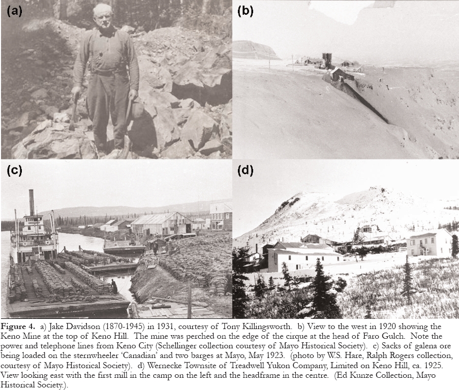
Display large image of Figure 4
Yukon Gold Company and Keno Hill, Limited
75 YGC was controlled by the Guggenheim family of New York. The patriarch of the family, Meyer Guggenheim, was an immigrant from Switzerland who had made money in the wholesale grocery business in Philadelphia and decided to buy a half-interest in a silver mine at Leadville, Colorado in 1879. After a ‘bonanza' lode was discovered, he and his seven sons then invested in a lead smelter at Pueblo, Colorado, which they gradually leveraged into the giant American Smelting & Refining Company (Asarco), a vast mining and smelting enterprise with operations in the U.S., Mexico, and Chile. In the period between 1906 and 1912, the words Guggenheim and copper seemed to be almost synonymous. The family held sizable or controlling interests in some of the largest mines in the world, including Bingham Canyon, Utah; Braden and Chuquicamata, Chile; Kennecott, Alaska; Ray and Chino, Arizona; and Ely, Nevada. Some of these mines are stillin production.
77 YGC, which operated from 1906 to 1925, had been a bit of a flier for the family and it turned out to be a financial disappointment. By the time YGC became interested in Keno Hill, its reserves were nearly exhausted and its operations in the Klondike had been reduced from nine dredges to two, plus a couple of hydraulic mining projects. As dredges became idle, they were being dismantled and shipped to other placer gold districts in places such as Malaya. YGC, like the Guggenheim family itself, was becoming a much less dynamic mining organization as the sons began to retire and their children chose to enter different fields (Hoyt 1967).
78 The top of Keno Hill was a small, windswept plateau above timber-line, without a water supply or road access. It was clearly an inhospitable and challenging place to build and operate a mine. In spite of this, YGC acquired the key claims and formed a new operating company called Keno Hill, Ltd. (KH). Between late August and early October, 1919, Schellinger sent three riverboats to Mayo, each loaded with about 70 t of mining and camp equipment. The last boat was frozen-in at Mayo for the winter. The freight was hauled the 68 km from Mayo to the site with horses and sleighs. The last half of the route was a poor winter trail and the final 6 km were up a steep hillside with an elevation gain of 760 m. Timber and water were hauled from local sources, a tent camp was built, and underground mining commenced on the available shipping ore.
Figure 5. Graph (prepared by Craig Hart, 2006) showing the annual average Ag price in $US/oz (grey bars) and the annual prices, adjusted for inflation using the US consumer price index (solid line), from 1913 to 2005, inclusive.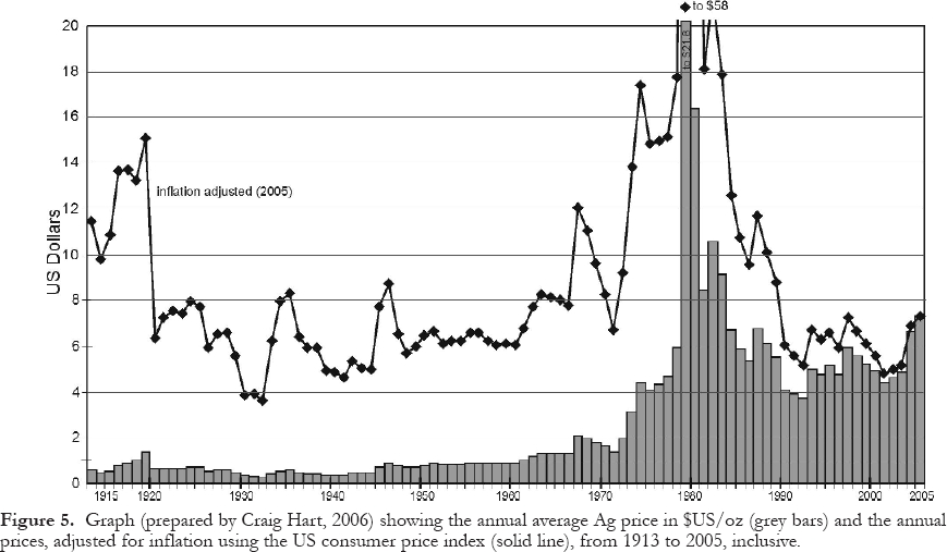
Display large image of Figure 5
79 Mining engineer R.H. Humphrey was sent from New York to manage the program and Schellinger became the mine geologist/engineer. A pattern was already being established in which the financial and technical people and foremen in the Keno Hill Camp were all Americans, with no involvement by Canadian or British mining interests. That trend would continue until 1945.
80 One of the main reasons that such a rapid start-up was possible in such a remote area was because of the large pool of experienced prospectors, miners, teamsters and other skilled workers who had been attracted to the Yukon and Alaska before and during the Gold Rush. Some of them had gained their experience in the gold placer and silver-gold hardrock camps in the southwest United States, British Columbia and Alaska. When the Keno mine was discovered, many of those men, including some veterans who had just returned from the Great War, flocked to the district to work at the mine or to prospect and stake claims. News of the YGC deal led to a staking rush in which over 500 claims were recorded during the first year, a number that gradually increased to about 1000 by 1923. At that time, each man was only allowed to stake one claim on each vein, and most could only afford one in the entire camp because of the cost and time required to perform the work needed to hold them. That is a good indication of how many prospectors and amateurs were attracted to the camp. Yukon lode claims (also called quartz claims) were staked with two posts and could be up to 457 m (1500ft) square, with a maximum area of 21 ha (51.5 acres).
81 Those who chose to remain in the district during the winter of 1919-1920 worked and lived at the mine (Fig. 4b), found accommodation in Mayo, or built a cabin on their claim if timber and water were available. Some built cabins in a new townsite called Keno City, which was established at the foot of Keno Hill beside Lightning Creek, a tributary of Duncan Creek. It was soon equipped with the usual amenities of a frontier town such as hotels, brothels, and saloons. Electricity was provided by a 75 KW powerhouse that consumed two cords of wood daily. Many of the prospectors spent the winter(s) working as teamsters, woodcutters, or hunters supplying moose and caribou meat to the mine and the community.
82 During that first winter, approximately 2000 t of shipping ore were mined by KH from a shaft and two adits and hauled to Mayo with horses in 50 kg burlap sacks. A thickness of over 3 m of galena was found in the best ore-shoot.
83 The main elements of the mineralogy and ore controls were quickly recognized by KH and GSC geologists. They had already noted the importance of quartzite and greenstone wall-rocks and began to distinguish between longitudinal and transverse veins.
84 The GSC deserves enormous credit for recognizing the significance of this new discovery and responding so quickly. At the time, the only means of communication between Ottawa and the territory was by telegram to Dawson or Whitehorse, or by mail. W.E. (Bill) Cockfield of the GSC was pulled off a project near Dawson in August 1919, and instructed to rush to the camp on one of the last boats of the year leaving for Mayo. He subsequently spent the summers of 1920, 1921 and 1922 in the camp. When he arrived in 1920, he learned that J.H. Farrell, a geologist from Los Angeles, had been hired by KH to map the top of Keno Hill with two assistants, P. Locke and C.E. Visel. They decided to collaborate, with Cockfield concentrating on regional mapping of Keno Hill and its extension to the northeast (Cockfield 1921; Williams 1922).
85 In the words of Aho (1972): "From this joint effort came the first picture of why ore occurred where it did and where more of it might be suspected … from then on, for years, it seemed that nearly every place that Cockfield had said to prospect, they found ore". There is, perhaps, no better example in the history of the GSC of the immediate impact of a Survey officer on mineral exploration. To quote Williams (1922), "With his assistants, (Cockfield) has played an important part in the development of the camp; ready at all times to give sapient instruction and advice to prospectors or to survey roads through the subarctic forests when no territorial funds were available, thus exemplifying the true scientific spirit in the best interests of the Survey". Bill Cockfield was in charge, later, of the Survey's Vancouver office, where he was highly respected.
86 It was not just prospectors who were attracted to the new camp. Visitors in 1920 included the Yukon Gold Commissioner, members of the Yukon Council, the Member of Parliament, and several senior officers from the Asarco office in New York. Governor-General Lord Byng visited in 1923.
87 The 1920-1921 mining program, under the direction of Frank Short, a San Francisco engineer and another Stanford graduate (1898), was even more aggressive, although mining was delayed for a few weeks by a miner's strike. The crew objected to the appalling conditions, living in cold bunkhouses with poor food, spending the few daylight hours underground, and drilling dry with hand-steel in dusty, freezing conditions. The strike was settled quickly when the company agreed to reduce the working shift from ten to eight hours at the same wage of $5/day, and to improve the meals and living conditions. A telephone line was also installed to Mayo. KH managed to ship about 3000 t in 1921.
88 As more veins were discovered, it became apparent that most of the ore occurred in transverse veins about 600m long, of which the 9 vein was the best. They were terminated by two longitudinal veins, the 1 vein (also known as the Main Break), which cropped out in Faro Gulch to the north, and the 6 vein, which crossed the top of the hill. Unlike elsewhere in the camp, good ore shoots were also found in the longitudinal veins. For a better understanding of the complicated vein pattern at the Keno Mine, see Boyle (1965). The best ore occurred where the transverse veins intersected a 50-m-thick greenstone body that formed a small knob on the summit, or a thick quartzite unit in the footwall that was separated from the greenstone by about 100 m of schist. Native silver and argentite, thought to be secondary in origin, were found in the Pleistocene ice that filled open spaces in the veins.
89 Based on its declining underground results and knowledge that the Silver King mine appeared to have bottomed in zinc mineralization and that many silver camps fail to persist to depth, KH became concerned about the future of the Keno mine. In the summer of 1922, with over 900 m of underground development completed on 12 veins, Superintendent Warren McFarland and consulting geologist Fred Hellman, from New York, were instructed to conduct a thorough appraisal. Hellman recommended that a reduced underground exploration program should be conducted and that the mine should be abandoned if it was unsuccessful. Based on thin section and polished section work, mineralogist R.J. Colony concluded that there was no secondary enrichment, that the ore consisted of vein filling with no replacement, and that ore shoots were only terminated for structural reasons.
90 Within a year, the end of the Keno mine came almost as Hellman had anticipated. By the time mining ended late in 1923 and the last of the ore had been shipped (Fig. 4c) to the smelter in 1924, it had produced an estimated 57.8 t (1.8 million oz) of Ag from 8425 t of hand-sorted ore with an average grade of approximately 6.86 kg/t (200 oz/ton) Ag and 54% Pb. Most of the ore had been mined from the 9 vein, which was up to 10-m thick and graded about 15.4 kg/t (400 to 500 oz/ton). The largest oreshoot contained 0.3 m of solid gale-na over a vein area of about 30 m by 20m. The cutoff grade for the mine was about 4.3 kg/t (125 oz/ton) Ag and 40% Pb, and thousands of tons of milling ore were either discarded or left unmined. The cost of hauling the ore to Mayo had been about $27/t, roughly the same as the cost to ship it from Mayo to the smelter in the United States. The production from the individual veins is grouped together under Keno mine in Figure 3 and Table 1.
91 The intersection point where the Keno veins would have passed through the top of the brittle rock formation and entered the overlying schist unit is very close to the present top of Keno Hill. If the top of the hill had received 5 or 10 m less erosion and the vein system had not been exposed by the glacial cirque on the north side, the veins would have been in schist at surface and unmineralized. In that case, the rich Keno ore would not have cropped out and the history of the camp might have been much different (Alan Archer, pers. comm., 2005).
92 While production was underway at the Keno mine, prospectors made several new discoveries at lower elevations northwest of the mine. Float from a vein that was later found to extend across three claims (Ladue, Sadie, and Friendship) was located as early as 1920 by Ray Stewart, Dave Cunningham and others and found to assay up to 17 kg/t (500 oz/ton). It would become the largest deposit found on Keno Hill. Other discoveries of rich float were made in 1921 on the Lucky Queen and Shamrock claims.
Bradley and Wernecke
93 Early in 1921, Frederick W. Bradley, who had visited the Lookout property in 1919, became sufficiently impressed by the news from the Keno Hill Camp that he agreed to buy the Gambler claim, located beside the KH property, for $10,000 - sight unseen. One of the most prominent mining executives in western North America, he was to have a major impact on the development of the Keno Hill Camp. Born in 1863 at Nevada City in the California Gold Fields, he dropped out of the University of California before graduation to return home and make his name at the age of 21 by saving the bankrupt Spanish mine through record-setting, low-cost mining and milling. In 1890, he became the manager of the new Bunker Hill silver mine in Idaho and was promoted to president in 1897. He then became involved in affiliated companies in the Juneau gold camp, becoming president of the Alaska Juneau mine in 1900 and the Treadwell Complex, an amalgamation of four adjacent mines on Douglas Island, across the channel from Juneau, in 1911. The Juneau camp, which had been in production since 1891, had interesting Canadian connections. The first lode showing, discovered by a French-Canadian, Pierre Joseph Erussard, was sold to John Treadwell from St. Stephen, New Brunswick. It was Treadwell who arranged the financing and construction of the first mill at Juneau, and whose name was later associated prominently with the Keno Hill Camp.
94 Bradley was a metallurgical expert whose principal contribution to the extremely low-grade Juneau Camp was in expanding the operations to achieve economies of scale, and introducing more advanced milling techniques. By 1915, the Treadwell Complex was milling about 4500 t/day in a 960 stamp mill, the largest in the world. By 1926, almost 23,000 t were being treated daily. Between 1898 and 1944, about 82 million t were mined underground at Juneau at the incredibly low grades of2.1 to 3.8 g/t (0.06 to 0.11 oz/ton) Au. Bradley was obviously comfortable with northern operations and was not afraid of technical or logistical challenges or financial risks. He served as president of the American Institute of Mining and Metallurgy in 1929 (Stone and Stone 1983).
95 Bradley sent his senior engineer and scout, Livingston Wernecke, to Keno Hill on the first boat in June 1921 (Fig. 6e). His instructions were to acquire properties of merit for a syndicate financed by The Bunker Hill and Sullivan Mining and Concentrating Company (the largest producer in Idaho's Coeur d'Alène silver camp), the Treadwell Alaska Company (from Juneau) and two smaller affiliates. Wernecke, who was Bradley's protégé, would go on to become the most important figure in the history of the Keno Hill Camp. He was named after the Montana town where he was born in 1883, had trekked over the Chilkoot Trail during the Gold Rush at the age of 15 as a member of an expedition to Alaska led by a botanist, had obtained a degree in geology and mining from the University of Washington in 1905, and then gained mining experience at Ely, Nevada and several projects in Alaska. From 1914 to 1921, he had worked for Bradley at the Alaska Treadwell and Alaska Juneau gold mines.
96 Wernecke visited all the active prospects and soon became a serious competitor to KH, which optioned the Sadie and Friendship claims for $70,000 in July (under the usual arrangement in the camp of 10% down) and offered $75,000 for the Ladue. KH broke off discussions with the owners of the Ladue claim when they countered with a demand for $500,000, which gave Wernecke an opportunity to begin negotiations. Having observed that the vein was wide and strong, that it cut the favourable greenstone and quartzite wall-rocks, and that the mineralization gave high Ag assays, he optioned the Ladue claim plus a few others for $260,000 over five years, with $20,000 down. This was a much more aggressive deal than the camp had seen before. The syndicate was incorporated as a new operating company, Treadwell Yukon Company, Limited (TYC), and suddenly the future of the camp looked much brighter. The only black cloud on the horizon was the Ag price, which declined to the $0.64 to 0.69 range in 1920, and remained there until 1929.
Treadwell Yukon Company, Limited
97 Now it was Wernecke's turn to show if he could be as competent as KH in coping with the transportation difficulties and short shipping season. By the end of September, a camp had been built and surface trenching had uncovered an ore shoot that averaged 10.1 kg/t (296 oz/ton) Ag and 41% Pb across a thickness of approximately 0.5 m, for a length of 120 m. Wernecke stated "If there's not a mine here, the text books are all wrong" (Aho 1972). Unlike KH, which never developed much confidence in the potential of the camp, Wernecke and Bradley believed from the beginning that sufficient reserves would be found to support a milling operation that could be supplemented with shipping ore.
98 Mining equipment was rushed from Juneau before the shipping season ended and William Hargreaves, a mining engineer with a degree from MIT and operating experience in Ontario gold mines, was brought in as Superintendent. By the spring of 1922, the camp had been enlarged to accommodate 60 men, two shafts had been sunk, 3600 t of 7.9 kg/t (230 oz/ton) shipping ore had been mined from above the 200 level and sent to Mayo, a large quantity of milling ore was stockpiled, a rough road had been built to Keno City, and a sawmill was in operation.
99 At the same time, KH had sunk a shaft on the Sadie claim and found 360 t of shipping ore and a large tonnage of milling ore. No permafrost was encountered there because it had been thawed by a nearby creek. In contrast, the Ladue #2 shaft reached the bottom of the permafrost at a depth of about 80 m, where it was forced to stop by water under strong hydrostatic pressure. By May 1923, Wernecke had obtained approval for a $1.5 million underground development program that included a drainage and production adit 790-m long at the 600 level. By the end of the year, TYC had blocked out over 27,000 t of 2.2 kg/t (64 oz/ton) milling ore and produced 7100 t of shipping ore averaging6.9 kg/t (202 oz/ton) Ag, 31% Pb, and 11% Zn. Discontinuous ore shoots had been found along the vein for a length of 500 m. By May 1924, plans had been completed for a 90 t/day bulk flotation mill using a flowsheet designed from metallurgical tests conducted in Juneau and pilot plant tests in New York.
100 When the 600 level was found to be mineralized only with a sideritepyrite assemblage containing minor freibergite, it became obvious that TYC did not have sufficient ore reserves. By negotiating a 10-year lease on the Sadie and Friendship claims with KH in August, Wernecke was able to reach the required ore reserve minimum of five years to justify the construction of the mill. KH was now reduced to the status of a claim owner and Schellinger became TYC's assistant engineer. TYC bought all the KH claims in 1934 for $25,000 (Bradley 1941).
101 By the time the river freighting season was over, all the mill equipment had been shipped to Mayo from Juneau and San Francisco. It was assembled at a new townsite that was situated at the Sadie-Ladue mine, on a gentle west-facing slope just below timberline. The townsite was named Wernecke (Fig. 4d). Interestingly, the house built at the mine for Wernecke and his family is the only building still standing. It was repaired and used during a surface high-grading program during the 1980s.
102 The mill was in operation at a capital cost of $200,000 by the beginning of 1925, and treated an average of 122 t/day of ore and produced 14.5 t of concentrate grading 20.8 kg/t (607 oz/ton) Ag, 55% Pb and 8% Zn, with minor Au and Cu, throughout the year. Recoveries averaged 97.6% for Ag and 92% for Pb. The bulk concentrate was shipped to the Bunker Hill smelter at Kellogg, Idaho. Smelter receipts from 1926 show that TYC was paid for 95% of the contained Ag and Au, and 90% of the Pb.
103 Bunker Hill had been noted for its poor labour relations. In fact, relations between the workers and management were so bad that its smelter was demolished in an explosion triggered by disgruntled miners in 1899, while an attempt to kill Bradley with a bomb placed outside his San Francisco home in 1904 was unsuccessful. Bradley had learned how important a contented workforce was to a productive northern operation when he became involved at Juneau. The Treadwell Complex had built comfortable bunkhouses and homes for its workers as well as impressive recreation facilities that included an indoor swimming complex and a library with 15,000 books and 150 magazines and newspapers.
104 While at Juneau, Wernecke had also learned the importance of maintaining a happy workforce. In spite of its remoteness, he ensured that the new townsite was a pleasant place to live and work. It was equipped with an excellent cookhouse and bunkhouses, a recreation building containing a pool hall, bowling alley, library, laundry, barber shop, radio room and silent movie theatre, as well as outdoor skating and curling rinks. A telephone line was installed to Mayo in 1923, which connected with a radiotelegraph link to Dawson and ‘outside' (the south). In the mine, wet drilling provided a safer and cleaner workplace and safety was encouraged. While no drunkenness or vice was tolerated in the town-site, it was always available in Keno City, which also offered tennis, a pool hall, a baseball diamond, and a trustworthy assay office operated by the territorial government.
105 Aho (1972) summarized his impressions of Livingston Wernecke as follows: "The Treadwell Yukon operations were a monument to Wernecke's dedication, engineering, efficiency, business ability and capacity to integrate government and social problems with pioneering the frontier of the north." Based on interviews with many of the camp pioneers, as well as the Wernecke and Schellinger families, Aho gained many valuable insights into his personality. His principal strengths were his imagination and vision as an explorer and developer. He was remembered as optimistic, efficient, frugal, taciturn, modest and shy, with little interest in social events. A workaholic with piercing eyes and a stern appearance, he could be grumpy and temperamental and was a terse communicator whose instructions were often confusing. As time went on, he became the autocratic ruler of the camp, a benevolent dictator whose word was absolute law. "He tolerated no interference from below and virtually ignored it from above."
106 In addition to getting the mine and mill up-and-running, another priority was to improve the freighting system and reduce shipping costs. In 1922, TYC purchased a Jeffery ‘Quad' (4x4) truck and a ‘5-ton' Holt Caterpillar tractor, which were used to haul 2000 cords of wood to the mine on winter roads. A year later, the company bought a second bulldozer, twice as big, to haul ore to Mayo and backhaul diesel fuel to run the generators. The bulldozers were capable of hauling over 25 t/trip, thereby replacing 96 horses and lowering the freighting cost from $26.00 to $8.50/t. Wernecke was so impressed that when he found a third one for sale on the Alaska coast in January 1924, he had it shipped to Whitehorse and sent a crew to walk it overland to Mayo. The 400 km trip was accomplished in 16 days. Aho (1972) suggested that this may have been the first overland cat train in Canada. Two more bulldozers were purchased for the winter of 1925-26, which resulted in the end of the horse era. When the drivers were put on a bonus contract, the two day return trip to Mayo was reduced to one day.
107 Whereas the path from float discovery to production had been quick and simple at both the Keno and Sadie-Ladue mines, the history of the Lucky Queen mine, situated uphill from the Wernecke townsite, could not have been more different. It had been staked in February 1920 by Hector Morrison, who found float assaying up to 29.7 kg/t (865 oz/ton) Ag and traced it to a narrow vein between a greenstone footwall and a schist hanging wall, from which he dug a few t of shipping ore by hand. Slate Creek Mining Co. optioned his ground for $5000 and paid him to continue prospecting but dropped the option in 1922 when the results were disappointing (Williams, 1922). While occasional specimens of rich float kept turning up and Morrison continued to drive short adits and dig pits and shallow shafts, he could not find a strong vein. No one would option or buy his claims, he could not even give them away, and he was almost ready to give up by 1927.
108 The next spring, acting on a friend's hunch, he dug in a new spot and found an impressive float train that quickly led him to an exceptionally rich vein about one metre thick,cutting quartzite. Although the mineralization was only about 15 cm thick where it was first intersected, specimens assayed as high as 58.3 kg/t (1700 oz/ton). According to Alan Archer (pers. comm., 2005), the Lucky Queen vein was the weakest structure associated with an important deposit in the entire camp. However, an adequate dilation zone had existed to form an orebody about 100 m long, which was cut off at both ends by weak cross-faults that only offset the vein about 3 m. The heart of the deposit was only 25 m long. Among the important producers, the Lucky Queen mine had the highest average grade in the camp, 3.06 kg/t (89.2 oz/ton), and the second highest Ag/Pb ratio at 12.8. Much of the Ag was present in pyrargyrite rather than freibergite, which was unusual within the camp. It was a unique deposit that broke all the camp rules.
109 TYC optioned the property immediately for $60,000 and Morrison, who was now 75 years old, retired a happy man. The discovery of the Lucky Queen mine came at a critical time because production was starting to decline at the Sadie-Ladue mine and a new source of mill feed was desperately needed. The Lucky Queen mine was also perfectly situated as it only required the construction of a headframe and a few buildings at the site, and an aerial tramline 1350 m long to the mill, and it was ready to begin production in the fall.
110 Although the future now looked bright again, everything changed a year later when the stock market crashed on October 29, 1929, the start of deeper economic problems that culminated in the Great Depression. The price of metals began to decline along with other commodities, with Ag and Pb reaching average annual lows of $0.25 and $0.03, respectively, in 1932. As prices dropped, the cut-off grade had to rise, resulting in smaller ore reserves. The miners agreed to take a wage cut and all other expenses were trimmed as much as possible. TYC hung on, hoping to outlast the hard times, but operations had to be suspended after the last ore from the Lucky Queen and Sadie-Ladue mines was milled in November 1932. If it had not been for the high-grade ore from the Lucky Queen mine, the end would have come earlier. The mill had operated 94% of the time for almost eight years, with recoveries of 94.7% for Ag and93.2% for Pb, a remarkable achievement.
111 In addition to the global economic conditions, Wernecke's problems were compounded by the death of Fred Bradley in July 1933, at the age of 70. He was replaced by his younger brother Philip R. Bradley, who was an 1896 Berkeley graduate in mining engineering. Phil Bradley had a Canadian connection that began in 1902 when he worked as a smelter foreman for the Mond Company in Sudbury. He then became superintendent of the Copper Cliff smelter for the Canadian Copper Company until 1905, when he moved to the Treadwell operations at Juneau. Although a competent operations man, he was much less optimistic about the potential of the Keno Hill Camp than his brother Fred because he believed that the mines had poor depth potential. Instead, he gave priority to spending TYC's working capital on diversification into the western U.S. and the Sudbury Basin. At Sudbury, for example, the Bradleys spent $10 million between 1922 and 1937 attempting to solve metallurgical problems at the Errington-Vermilion property, a Zn-Cu replacement-type, massive sulfide deposit. As a result of low Ag prices and the transfer of profits to other Bradley projects, TYC was broke by 1937 and had to be reorganized, after which it was only able to spend its meagre operating profits on exploration.
TYC Exploration Program
112 Until forced to stop by the Depression, Wernecke and Bradley had also conducted an aggressive Territory-wide reconnaissance exploration program, supported by a company-owned, float-equipped Fairchild aircraft. This pioneering venture that began with six, 2-man parties of experienced prospectors in 1929, expanded to ten parties in 1931, and ended with one party in 1933. It was conducted at a time when topographic maps were quite generalized, there were no navigational aids, and geological mapping had only been conducted over a small part of the Yukon. Several promising showings were reportedly found although no specific, detailed records have survived. There was no follow-up until after the Second World War, at which time the prospectors realized that they could not relocate the showings because TYC had withheld accurate geographical information from them.
113 After the Wernecke mill was closed at the end of 1932, TYC was forced to suspend all operations until economic conditions improved and to focus its efforts on exploration and planning. The best new discoveries had been made on Galena Hill for a number of years and there was no obvious source of mill feed left on Keno Hill, hence priority was given to proving enough new reserves to justify moving the mill to Galena Hill. TYC did not own any property there, so Wernecke had to put his deal-making hat on again. The rich option he had agreed to on the Ladue claim back in 1921 had signalled to prospectors that TYC was willing to pay high prices for good deposits. This became a powerful incentive to prospectors to scour Galena and Keno Hill during the Depression because they knew that systematic and diligent work, and luck, would be well rewarded. In this way, TYC guaranteed that free exploration would continue at a steady pace.
114 In addition to large cash payments for good discoveries, Wernecke had always been generous to genuine prospectors and he continued this policy during the shutdown by providing personal loans, grubstake support, free assays and explosives. This policy was complemented by support from local merchants. Equally important, he had gained a reputation with the prospectors as a tough but fair negotiator who was always willing to give free advice and encouragement.
115 The exploration techniques developed in the camp during the 1920s and 1930s were both innovative and effective. Prospectors had realized early on that the techniques developed in the north to locate buried placer gold paystreaks were equally effective in searching for galena dispersion trains. The first step in exploring a claim was to dig shallow hand pits in the frozen over-burden. If no mineralized float or out-crop was found and overburden was deep, the pits were converted into shafts and deepened to bedrock, with the various overburden layers panned for the presence of galena, anglesite or siderite. This was a simple and inexpensive technique that required only a hand-built wooden windlass, a hoisting bucket, firewood, a steam boiler and steam ‘point' (a hollow iron or steel rod that was connected to the boiler by a rubber hose), and a lot of hard work. Steam was used to thaw the overburden at the bottom of the shaft. The shafts were only large enough in diameter to accommodate the prospector and a ladder, therefore they could be sunk quickly. If evidence of a mineralized vein was found, a fence of shafts was then sunk uphill until a vein was found or the upper boundary of the claim was reached. Unfortunately, the technique did not work in glaciated areas where the float trains had been scoured away. If water was available from a creek, ground sluicing was used to expose bedrock. It is quite remarkable how much effective exploration was achieved during this period without the aid of geological maps or research, and in spite of the challenges created by permafrost, poor outcrop and a short summer.
116 This exploration shaft technique was a crude form of deep soil sampling for Pb and Ag. Factors that contributed to the efficiency of the technique were: a) the permafrost became a helpful aid because it reduced the danger of slumping walls and eliminated the need for timber support; b) it could be conducted safely year-round as long as water or thawed ground was not encountered during the warmer parts of the year; c) the Ag-rich galena in the float trains was relatively untouched by surface oxidation except for alteration to anglesite, which did not affect the Ag content; d) if the Ag content of the galena was found to be fairly high in the initial assays, the prospector could concentrate on following the galena without paying for a lot of additional assaying. The high Zn content of the veins was not a useful exploration guide because sphalerite usually had a low Ag content and seldom appeared in float trains because it oxidized too quickly.
117 The principal danger was that groundwater, trapped beneath the permafrost layer under hydrostatic head, could flood the shaft very quickly if thawed ground was intersected. Another serious problem could arise if air trapped below the permafrost became oxygen-deficient as mineralization was oxidized and was released into mine workings, resulting in potentially fatal breathing conditions.
118 The best measure of the success of Wernecke's incentive programs was that TYC gradually acquired control over most of the best orebodies in the camp, except the Husky, which was covered by thick glacial drift and wasn't discovered until much later. TYC normally entered into an option to purchase or a lease because Wernecke did not believe in owning large claim positions. In fact, the most that TYC owned at one time was about 60 claims.
119 Prospectors had started to uncover promising showings on Galena Hill as early as 1924. Charles Brefalt (Fig. 6a), who was probably the most proficient prospector/miner in the camp, and who was involved in one way or another with almost every significant mine in the camp, found low-grade float that year and staked it as the Elsa claim. Although he was one of Wernecke's favourites, Brefalt repeatedly turned down offers of employment with TYC, preferring to work as an independent contractor or miner. In 1925, he discovered some freibergite-rich galena less than 200 m away from his original Elsa discovery that assayed as high as 100 kg/t (3000 oz/ton). Ground sluicing soon showed that it came from a vein 4.9 m wide that was covered by only one m of overburden. After he and a partner had recovered 8 t of 15.8 kg/t (465 oz/ton) float, Wernecke tried to option the new discovery for $250,000 but Brefalt wisely decided that he would be better off mining the surface ore himself. In his typical generous fashion, Wernecke urged the Territorial government to construct a winter road from the Silver King mine to the Elsa claim to help Brefalt achieve his goal. In 1928, after the easy ore had been mined and Brefalt had earned a nice profit, TYC optioned the property for $150,000. He was then hired to supervise the underground exploration. In 1934, TYC hauled 2840 t of shipping ore averaging16.8 kg/t (492 oz/ton) Ag and 30.6% Pb out of the Elsa mine.
120 Because of the impressive new Elsa discovery and intermittent success at the Bermingham mine, Sandy McPherson optioned the Silver King claim from Tom Aitken in 1928 and Jack Hawthorne soon made a deal with Jack Alverson on the adjoining Webfoot claim to the northeast. After a disorganized start, both parties discovered exciting new vein extensions the next year and TYC optioned both, agreeing to pay $125,000 for the Silver King claim and $300,000 for the Webfoot.
121 The higher price for the Webfoot was justified by the 7.6 m width of the vein, on which mining of shipping ore commenced immediately. About 170 t grading 10.8 kg/t (315 oz/ton) were hauled to Mayo the next winter. As luck would have it, the stock market collapse and dropping Ag price occurred while the ore was enroute to the smelter and receipts were much less than anticipated. Mining stopped abruptly when the Webfoot owners, unwilling to accept that economic conditions were deteriorating, refused to renegotiate the terms. TYC eventually bought the claim several years later for about $58,000 and arranged for a 10-year lease on the Silver King claim for $39,000.
122 The next discovery on Galena Hill was on part of an enormous, wide, branching vein system that would eventually become the Hector-Calumet mine, the greatest prize in the camp. The history of this discovery was frustratingly slow, somewhat like the Lucky Queen mine. The Hector and Calumet claims were staked in 1920 and 1921, respectively, by Clem Sinyard and Harry Colley, both of whom found rich float but were unable to trace it to a strong vein. Exploration was sporadic until 1934, when Colley and partners found a high-grade showing on a minor branch of the vein system in a shaft on the Calumet claim. Schellinger helped Sinyard locate a similar showing on the adjoining Hector claim (Figs. 6a). Although both turned out to be small lenses of ore, Jack Boon, a contractor, found a better branch of the vein-fault on the Calumet claim in the spring of 1935, from which they soon shipped 300 t of ore. The price of Ag had recently risen to $0.64, and Wernecke was regaining some of his old optimism and he hurried to see the new showing. In spite of the economic slump, he was so impressed by the brittle quartzite wall-rocks and the strength of the structure that he trusted his instincts, which he had developed by examining every showing in the camp, and immediately optioned the Calumet claim (the price is unknown). A few weeks later, Sinyard found an equally impressive vein on the Hector claim, and Wernecke optioned it for $200,000.
TYC Resumes Milling on Galena Hill
123 With the largest ore reserves in its history now available at the Silver King, Elsa, and Hector-Calumet mines, and the average Ag price rising in 1934 and 1935 to the $0.54 to 0.58 range, it appeared that the time was right for TYC to begin milling again. The mill was moved from Wernecke to a new townsite situated beside the Elsa mine, enlarged to 225 t/ day, and was back in operation by the end of 1935. The new townsite was not only quite a bit closer to Mayo, it was also much lower in elevation and had a far better water supply. In addition to its excellent potential for milling ore, the new Hector-Calumet mine (Figs. 6a, b) was also conveniently situated. A 4325 m aerial tramline with a vertical drop of about 400 m was built to transport the Hector-Calumet ore to the Elsa mill, partly with equipment salvaged from the Lucky Queen tramline (Fig. 6d).
Figure 6. a) Clem Sinyard's first shaft on the Hector claim, 1935. From left to right: Charles Brefault, Malcolm McCown, "Little Nick" Milosevich, Elmer Gustaveson and Clem Sinyard: (Schellinger collection, Yukon Archives, courtesy of Mayo Historical Society). b) Driving the 400 Level adit on the Calumet claim in 1937. It later became the main production heading for the Hector-Calumet Mine. (from H.S. Bostock's ‘Pack Horse Tracks, 1924-1954', Yukon Geoscience Forum, 1990; Natural Resources Canada image 83135 produced with permission of Natural Resources Canada. Her Majesty the Queen in Right of Canada). c) A.K. Schellinger in 1937. (Aho collection, courtesy of Mayo Historical Society). d) View from Galena Hill looking west down the aerial tramline from the Hector-Calumet Mine, with the Elsa mine, mill and townsite in the foreground, 1939. Mount Haldane (Lookout Mountain) is in the center, with the Silver King Mine and the road to Mayo on the left and the South McQuesten River on the right. (W.S. Hare fonds, print 6869, Yukon Archives.) e) Livingston Wernecke, undated (Yukon Archives).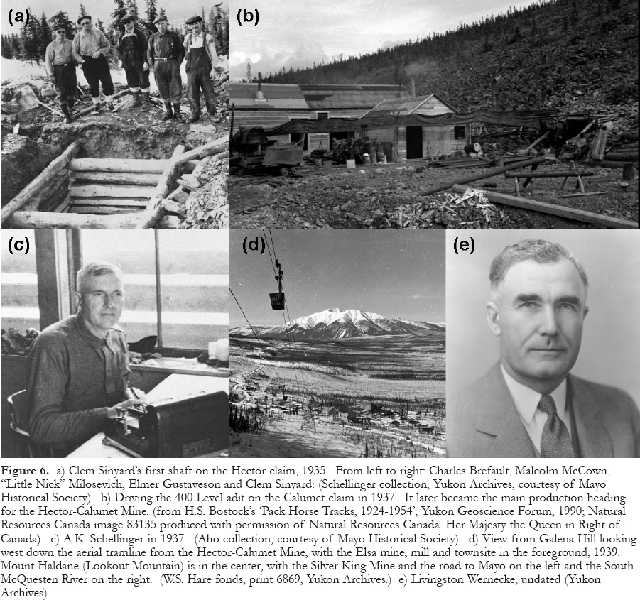
Display large image of Figure 6
124 Many people find it surprising that Elsa's lower elevation did not result in milder winters than those at the Wernecke townsite (or the later Calumet townsite). The reason was a temperature inversion that occurs in the northern mountains during severe cold spells. The cold spells are typically accompanied by still air with virtually no wind, which results in colder air settling into the valleys and temperatures becoming noticeably colder than they are even a few hundred metres higher in elevation.
125 Road transportation was provided by 9-ton Moreland trucks, which could haul 16 t of ore (300 sacks) to Mayo daily on a new route that followed the old Silver King winter trail across the low divide at the west end of Galena Hill to join the original Duncan Creek road. This reduced the transport cost to Mayo from $16.50/t to $10.
126 Unfortunately, Elsa was a far more basic townsite than Wernecke had been because the Ag price declined again, averaging only $0.43 to 0.45 from 1936 to 1938. The only buildings aside from the mill were bunkhouses, a cook-house and a machine shop. There was no school, church or recreation centre. After the death of Fred Bradley, Wernecke had been forced to spend more and more of his time in San Francisco on the management of other Bradley projects. As a result, discipline was weaker and bootlegging and absenteeism were serious problems. Although mining productivity and mill recovery began to decline and the operation appeared to be more hand-to-mouth and day-to-day, the three mines were so productive that they turned out more than the riverboats could haul from Mayo. In 1937, the sternwheeler ‘Keno' made 39 round trips from Mayo to the Yukon River and transported about 8150 t, second only to the 10,800 t moved in 1922. In 1938, the tonnage shipped increased by another 2%.
127 Mining was conducted at the Silver King mine until 1939 but was terminated because the ore was becoming more Zn-rich at depth, which was interpreted as the bottom of the deposit. Although mining was stopped at the Hector claim in 1937, when a dispute between the two owners prevented a revised option agreement from being signed, mining continued at the Elsa mine and the Calumet claim (Fig. 6b). Independent miners conducted small-scale mining at the Bermingham and No Cash mines and shipped their ore to the mill. The low Ag price forced the cut-off grade to rise to about 2.0 kg/t (60 oz/ton). In June 1939, crude ore assaying up to 34 kg/t (1000 oz/ton) was being sacked at the Elsa mine. Using a cut-off grade of about 6.8 kg/t (200 oz/ton), the sacks averaged about 24 kg/t (700 oz/ton). The mill was processing a head grade averaging about 1.7 kg/t (50 oz/ton) with a recovery of 83% (Bradley 1941).
128 Economic and political problems finally forced TYC to terminate operations on October 21, 1941. The final blow was a decision made by the U.S. government at the beginning of May that it would not buy any more foreign Ag. In addition to low metal prices, the most serious factor that influenced the closure decision was a labour shortage that began after Canada joined Great Britain in World War Two in September 1939 (the United States did not enter until December, 1941). Furthermore, a fear that the camp had poor depth potential was a persistent concern for some people.
129 Wernecke had overcome the difficult challenge of finding sufficient reserves and building new mining operations, first on Keno Hill and then on Galena Hill. He had devoted the best twenty years of his life to overcoming all the technical and geological challenges, and had gradually become convinced that all his effort had been in vain. The Great Depression had come at a most inopportune time for TYC. The global economic problems that were beyond his control had caused him to become increasingly embittered, cynical, temperamental, opinionated and impatient.
130 Wernecke was notorious for driving too aggressively and for pushing his pilots to fly in bad weather. His luck finally ran out on October 31, 1941 while he and his pilot, Chuck Gropstis, were returning to San Francisco after informing the crew at the mine about the closure. They were killed when their Bellanca Skyrocket float plane crashed in bad weather on tiny Salal Island, situated in Millbank Sound on the British Columbia coast, about 200 km north of Alert Bay.
131 A bizarre coincidence was associated with the crash. Wernecke's plane was circling a downed aircraft that had made a forced landing in the water at the same location just a few minutes earlier. Although that plane had flipped over, the two occupants managed to swim to Salal Island without any survival gear. By a stroke of good luck, they were able to locate the food and equipment in Wernecke's plane and survived until searchers in a boat found them a few days later. If the wreckage of Wernecke's plane had burned, the other pair would surely have perished from exposure.
132 Wernecke's tragic death resulted in the demise of TYC because the company had now lost its champion. Most of the assets were sold except for the mill, the tramline and the mineral claims, with much of the equipment being acquired by the U.S. Army for the construction of the Alaska Highway and the Canol Road and pipeline from Norman Wells to Whitehorse.
133 Although word of his accomplishments never reached Toronto and Livingston Wernecke (Fig. 6e) was never inducted into the Canadian Mining Hall of Fame, he received a far more significant tribute from the Canadian government, which recognized his contribution to Yukon mining by naming a rugged and well-mineralized, northern branch of the Rocky Mountains after him. The Wernecke Mountains are situated about 125 km north of the Keno Hill Camp. He shares this honour with other outstanding northern explorers who had branches of the northern Rockies named after them, men such as Sir Alexander Mackenzie, Sir John Richardson (companion of Sir John Franklin), Alfred Selwyn (second Director of the GSC), and William Ogilvie (pioneer surveyor and Yukon Commisioner during the Gold Rush). In 1999, Livingston Wernecke was inducted into the Alaska Mining Hall of Fame.
134 Over a period of 17 years and 8 months, TYC had produced 1381 t (44.41 million oz) of Ag and 43,772 t of Pb, of which almost 60% was from Keno Hill. In decreasing order of size, the main mines were: Sadie-Ladue -29.0% of the total, Lucky Queen -26.8%, Silver King -17.5%, Elsa - 20.5%, and Hector-Calumet -10.7%. This represented approximately 85% of the total production from the camp up to that time. About 81% of the Ag came from 543,040 t of milling ore with an average grade of 20.6 kg/t (60.15 oz/ton) Ag and 6.3% Pb. The balance was from 22,150 t of direct shipping ore that averaged 11.8 kg/t (345.0 oz/ton) Ag and43.6% Pb. No Zn was recovered or paid for by the smelter.
1945 to 1989
Lindsley and Connell
135 In early 1945, just before the end of World War II, Thayer Lindsley of Ventures Ltd and Frederick Martin Connell of Conwest Exploration Company, both based in Toronto, became interested in the potential of the Keno Hill Camp. This was a strong partnership between two giants of Canadian mining. The American-born Lindsley, who studied geology and mining engineering at Columbia University before moving to Canada, was known as the ‘Dean' of Canadian mining. Connell, who was born and raised in Ontario and studied geology at Queen's University, was generally regarded as his successor. The two were dynamic, practical and visionary, and both shared a love of geology and mining. Connell, who had served without remuneration during the war as Canadian Metals Controller, was well connected politically, an important consideration if there was any hope of reducing production costs in the camp.
136 Their first move was to send two consultants from Toronto, John Reid and Frank Buckle, to make a thorough examination with the assistance of Charles Brefalt and other local experts. Reid, whose nickname was ‘Turn-em-down', felt that the mines had been worked out and the camp was little more than a salvage operation. In a longer and more detailed report, Buckle concluded that the camp had been inadequately explored, that operations in the latter years had been sloppy, and that considerable operating efficiencies were possible. Most importantly, he believed that the orebodies would persist to greater depths, particularly the Hector-Calumet and Elsa mines.
137 Lindsley and Connell accepted Buckle's recommendations and signed an option agreement, exercisable at the beginning of 1946, to acquire all the assets of TYC for $75,000 and 750,000 shares of a new company, Keno Hill Mining Company Ltd, that was to be formed by Conwest and Frobisher Exploration Company Ltd, a Ventures subsidiary. Conwest served as the operator until 1961, when Frobisher merged with its subsidiary, Falconbridge Nickel, and became the operator by purchasing Conwest's interest.
138 The Elsa, Calumet and 84 other TYC claims were acquired, all but the Hector claim which was still subject to a disagreement between the two owners. It was soon purchased for a total price of $400,000. Buckle was placed in charge and spent the next summer gaining access to the underground workings, including the 485 m long production adit on the 400 level of the Hector-Calumet mine (Fig. 6b), refurbishing the mill and power plant, repairing the tram-line, and so on. Experienced labour was scarce, the winter of 1946-47 was one of the coldest on record, and the rehabilitation program proved to be much more difficult than anticipated. With over $1 million invested and still no production or new ore reserves, H. Brodie Hicks was brought in as the new General Manager from another Conwest operation, Central Patricia Gold Mines. In addition, W.O. McBride was appointed Chief Geologist, probably the first person other than Wernecke to have held that responsibility. Although Buckle did not play a significant operational role, it was his vision that had persuaded Lindsley and Connell to become involved.
139 Under the new management, exploration drifting and underground diamond drilling soon began to unravel the complexity of the branching Hector-Calumet vein system and outlined additional reserves at the Hector end of the mine, although the high zinc content of the ore at the 400 level was a serious concern. Meanwhile, Brefalt showed them promising places to explore at Elsa, including mineralized backfill that TYC had thrown away. The mill began operating in April 1947 with a target of 90 t/day. By early 1948, over 3.1 t (100,000 oz) of Ag and 110 t of Pb were produced each month and shipped to the Asarco smelter at East Helena, Montana. The price of Ag had climbed back up to the $0.60 to 0.80 range and Pb had doubled to a dime. Even Zn looked like it might be worth shipping someday. As the cut-off grade was lowered, ore reserves began to increase. The property holdings increased to 232 claims.
140 The next challenges were to reduce power costs and improve the transportation system. To address the former, the Tantalus Butte coal mine at Carmacks was purchased and cat trains began to haul 900 t of coal to the mine from Carmacks each winter. The transportation problem had two parts; first, reliance on a seasonal riverboat system resulted in a bottleneck that limited outgoing ore shipments to about 11,000 t annually. Second, stockpiling ore for eight months of the year caused serious cash-flow problems. Connell and Lindsley decided to use their considerable influence to persuade the Federal and Territorial governments to construct a road from Whitehorse to Mayo. Construction of a gravel highway began the next year.
United Keno Hill Mines Ltd
141 A turn-around came in 1948 when a major new oreshoot was discovered on the 3 vein below the Hector-Calumet 400 level (described in more detail earlier under Ore Controls). When it became obvious that new ore shoots could be found below zinc-rich zones and the company would not be a mere salvage operation, it was refinanced to provide additional capital for expansion and the corporate name was changed to United Keno Hill Mines Ltd (UKHM). Renewed optimism translated into longer range planning, increased exploration and capital investment. Since it was clear that the Hector-Calumet mine was going to become the largest in the camp, a new townsite named Calumet was built there to house the growing number of engineering, geological and mining staff plus the underground workforce for that mine. Important amenities were added at both townsites, including new ‘Panabode'' log homes, recreation halls, churches and curling rinks.
142 The most notable event of 1949 was the destruction of the Elsa mill by fire in June. By diverting the mining crew to assist in reconstruction and by scouring British Columbia for used equipment, a replacement mill was in operation before the end of October, at an increased capacity of 225 t/day. The bright spot was another doubling of the ore reserves. In spite of the millfire, about 6350 t of concentrate were shipped during the year.
143 For the next few years, the operation steadily improved and was gradually transformed into a modern industrial enterprise. When a study in 1949-50 showed that a hydro plant on the Mayo River was feasible, a federal power agency began construction in 1951 of a 3000 HP plant, which was completed in November 1952. It resulted in a significant reduction in diesel, coal and wood consumption and a drop in power costs from $650 per HP-year in the early 1920s to $150 (Johnston and Powelson 1951).
144 In 1950, the 467 km gravel highway, which included three river crossings using ferries in summer and ice bridges in winter, was completed from the mine to Whitehorse. This led to the inevitable end of the riverboat era and eliminated winter stockpiling of ore. During the winter of 1948-1949, for example, the stockpile in Mayo had been worth $1.7 million. UKHM formed a trucking division that lowered shipping costs to about $50/t from the mine to the smelter.
145 The three bridges were completed across the Yukon (at Carmacks), Pelly and Stewart Rivers during the 1950s, finally creating an all-weather highway from the camp to the outside world. At the former Keno mine, a new, deeper oreshoot was discovered on the 9 vein. Geologist Bill Smitheringale Sr., was loaned to UKHM by Conwest to study the Elsa mine. Shipments to the smelter were almost $2 million and the operating profit was almost $500,000.
146 The Zn price had risen significantly and a differential flotation circuit was installed in 1950 to produce a Zn concentrate for shipment to the Cominco smelter at Trail, B.C. UKHM was also paid for the significant cadmium content in the Zn concentrate, then selling for over $4/kg. In 1951, mill capacity was enlarged to 450 t/day and a cyanide circuit was installed to treat tailings from the flotation circuit, which increased Ag recovery from 80 to 91%. This also made old tailings from the Wernecke mill, which averaged up to 620 g/t (18 oz/ton), worth hauling to Elsa for retreatment.
147 Connell and Lindsley now turned their political talents to the subject of tax treatment for ‘new' mines. At that time, the rules stipulated that new mines were exempt from taxes during their first three years of production, starting after the period of exploration and underground development. This generous treatment was intended to encourage the opening of new mines by providing the developer with the opportunity to quickly recover a significant portion of its capital costs, thereby lowering interest payments on the debt. UKHM was able to obtain favourable rulings that stretched the commonly accepted definition of a new mine. For example, it obtained new mine status for individual veins within the same vein system and managed to stretch out the exploration and development stage far more than was usually possible. New ore shoots found by exploration beneath the original Keno mine in the late 1950s were classified as a new mine and almost 25% of the ore had been removed in the name of exploration before the clock started on the three-year period (Alan Archer, pers. comm., 2005).
148 By the end of 1950, the ore reserves had jumped to 300,000 t grading 1.6 kg/t (46 oz/ton), of which over 85% was in the Hector-Calumet mine. Production from the 3, 4, and 5 veins soon exceeded the entire output from the rest of the camp to date. Many parts of these ore shoots exceeded 10 m in thickness and some of the ore was lost because of caving before square-set mining was introduced in unusually wide or unstable areas. The 300 and 400 levels of the mine were producing about 3300 t/vertical m at an average grade of about 1.65 kg/t (48 oz/ton) Ag, 8.6% Pb and 5% Zn. Parts of the upper levels were more heavily oxidized than normal, which lowered recoveries at themill. By the end of 1952, the Hector-Calumet deposit had been confirmed down to the 775 level and the company was producing almost 20 t (625,000 oz) of Ag per month in 1953.
149 An astute but lucky discovery was made at the Elsa mine in 1957 when a freibergite-rich oreshoot was discovered in a very weak footwall branch structure, designated the 15 vein. First recognized in a stope on the 5 vein just above the 525 level, it thickened into a fractured zone about 20 m wide at the junction of the two veins with an average grade of about 4.7 kg/t (150 oz/ton) Ag and a Ag/Pb ratio of about 20. The 15 vein, which dips only 30-40° (one of the flattest in the camp), was unmineralized at the 400 level but suddenly blossomed into a new and incredibly rich oreshoot that was centred on the 200 level and extended to surface. The core of this bonanza was about 50 m long in the dip plane of the vein, 30-m wide in the strike direction on the 200 level, and 2 to 3-m thick, with a rake of 30°. At the 200 level, the ‘15' vein ore-shoot was situated within a part of the mine that TYC had worked in the 1930s and had missed by 30 m when a drift passed through a small cross-fault that offset the vein.
150 The 15 vein was the richest in the camp, producing an estimated 310 t of Ag (about 10 million oz), or about 75% of the Elsa mine total. According to Alan Archer, who was the Elsa mine geologist from 1958 to 1963, about 140t (4.5 million oz) of the 15 vein production came from the bonanza oreshoot, with the balance from the 5-15 vein junction. The bonanza ore consisted of heavily disseminated freibergite in siderite. Specimens of this ‘pure' freibergite assayed up to about 257 kg/t (7500 oz/ton). The oreshoot was composed of a rich core of about 2700 t that averaged about 52 kg/t (1500 oz/ton). In places, the hanging-wall was oxidized to argentojarosite for a thickness of up to 0.6 m, which averaged about 40 kg/t (1200 oz/ton). The oxide ore was mistakenly milled, with a recovery of perhaps only 30%, even though it was richer than the Pb concentrate and should have been sacked as shipping ore. The 15 vein, like the Lucky Queen vein, served as a frightening reminder of how a small but incredibly rich oreshoot on a minor branch vein could be easily missed, even with detailed mapping and exploration.
151 In underground mines, it is normal practice for mine geologists to supervise samplers, select cut-off grades for high assays, and calculate ore reserves, because they are most familiar with the variability of the ore. At UKHM, on the other hand, that responsibility was assigned to the engineering department from 1946 until the early 1970s. The policy was instituted by Fred Connell, himself, who reportedly did not trust geologists, for whatever reason (Bill Case, pers. comm., 2006).
152 Because all the ore arriving at the mill from the different mines and individual stopes was dumped into a common ore bin, muck sample assays were used to allocate the silver produced in the mill each day back to its source. This was also a way to ensure that the ore mined in each working place was valuable enough to be sent to the mill. In spite of its importance, muck sampling at UKHM was performed in a casual fashion. The tramming crew was supposed to collect a small shovelful from the top of each mine car and combine them into one composite sample that represented all the cars hauled from each mining area (stope, raise or drift), sometimes up to 15 or 20 t of ore. Chip samples were collected more carefully by the engineering department after every blast and were used, along with muck sample grades, for ore reserve grade calculations and to assist with visual geological grade control.
154 When an oreshoot exhibits wide variations in grade, like the raisins in a pudding, it is standard practice to use statistics to select an arbitrary level, called the cut-off grade, which can be used to reduce the distortion caused by samples that are very high because they happen to contain a lot more raisins. Assays that are much higher are cut to that grade so they will not unduly distort the average. Choosing the proper cutoff requires both statistics and familiarity with the ore. During periods of high profitability like those prevailing at Keno Hill, management practices can become less vigilant or even sloppy. A good example occurred at the Elsa mine between 1959 and 1964, when the mine grade increased sharply because of the discovery of the 5 and 15 vein ore shoots. Elsa muck assays had been previously cut to about 5.4 kg/t (175 oz/ton) Ag, which was appropriate. The same cutting level was maintained after 1958 even though a much larger proportion of the muck assays were now higher than that level. A somewhat similar mistake happened in reverse at the other big producer, the Hector-Calumet mine, where a cut-off grade of about 3.9 kg/t (125 oz/ton) had been adopted during the mining of the rich 3 and 4 veins. After 1956, as the average grade there began to steadily decline, the old cut-off grade was maintained even though far less than 5% of the muck assay exceeded that limit (Alan Archer, pers. comm., 2005).
155 The actual amount of Ag produced from the Elsa and Hector-Calumet mines during this period is unknown because the cut-off grades bore little relationship to the actual mine grades. The result was that a large amount of the production from the Elsa mine was actually credited to the Hector-Calumet mine. What made this situation more serious than simply a case of sloppy management was that the richest part of the Elsa mine was in its three-year tax-free period. As a result, UKHM increased its tax bill by crediting tax-free ore from Elsa to another mine that was in a higher tax bracket.
156 A similar situation, without the tax implications, occurred during the mining of the rich Husky mine (Fig. 7a) in the 1970s and 1980s. The geologists who were in charge when the Husky was mined believe that the ‘official' grades shown for all the richer mines operated by UKHM during that period are too low and that the reverse is true for the lower grade mines. The scale of these transfers is not precisely known and no attempt has been made in this paper to revise the ‘official' production records (summarized in Table 1) that were reported to shareholders and tax authorities. There is little doubt that some marginal mines were kept in operation when they were actually losing money.
157 UKHM's outstanding results led to a staking and speculative frenzy in the camp between 1949 and 1954. During 1951, no less than 42 junior companies were formed on ‘Keno' properties, most of which acquired claims and performed exploration. The participants were mainly Ontario-based promoters along with a few more senior companies such as Noranda, Hoyle Mining Company, and Karl Springer's Northwestern Explorations Ltd. John R. O'Neill, the busiest promoter, formed several junior companies that eventually merged into Galkeno Mines Ltd in 1957. Galkeno and another O'Neill company, Bellekeno Mines Ltd were the most successful. They built a 135 t/day mill near Keno City and treated 102,400 and 10,500 t, respectively, between 1953 and 1956. UKHM purchased Galkeno's assets in 1958 and Bellekeno's claims in the mid-1960s.
158 Comstock Keno Mines, another successful junior, found ore-grade mineralization on the Porcupine vein, a longitudinal structure downhill from the Keno 6 vein (Fig. 3b). The discovery was a few hundred metres along strike to the northeast from the original Porcupine occurrence, which had been explored with a shaft about 1929 (Fig. 7b). Barry O'Neil leased the Comstock property and high-graded a small lens of massive galena, about 8 m long and up to 2 m wide, that assayed about 5.1 kg/t (150 oz/t) Ag. Several years later, UKHM intersected this vein in the Keno 700 level adit and discovered, while mining it under a lease, that the massive galena was bounded by gouge and non-descript, oxidized vein material that assayed about 8.6 kg/t (250 oz/t). This was just one of many examples in the camp of the need to use assays to check visual estimates (Alan Archer, pers. comm., 2005).
159 Most of the junior companies and independent miners were unsuccessful, although a few of them were able to ship small tonnages of high-grade ore. A few introduced new ideas into the camp. Klondike-Keno Mines Ltd, for example, performed the first surface diamond drilling in 1951 under the direction of Jack Walli and Murray Watts. In 1953, Jersey Yukon Mines Ltd conducted the first geophysical survey under the guidance of Hans Lundberg.
160 The UKHM approach to land acquisition was completely different from the TYC policy. By 1958, the company owned about 600 claims, most of them dating back to the 1920s and 1930s, and many of the key claims containing mineral occurrences or extensions were surveyed and converted to 21-year leases. With little competition, company policy was to either buy existing claims if the price was right, or wait until they lapsed when the owner died or lost interest, and then restake them.
161 When the fortunes of the Keno Hill Camp and UKHM reached their peak about 1960 and the Hector-Calumet mine began to show signs that it might become zinc-rich at the 1175 level, Conwest shrewdly sold its 25% interest to Falconbridge for $3,750,000 ($6.00 per share). Between 1961 and 1963, the price of Ag increased to $1.29 from 0.90. UKHM had been wildly successful at finding new ore in several of the original mines. For example, it found almost all the ore in the Hector-Calumet mine and eventually produced more than four times as much Ag from the Elsa mine as TYC had found, half as much again from the Silver King mine, and almost six times as much from the Keno mine as KH had found. However, it had not found any new large deposits. With the easy discoveries apparently already made, UKHM decided that a more aggressive underground program and systematic, modern, surface exploration methods were needed.
Modern Exploration Program
162 In early 1963, Chief Geologist Alan Archer and Consulting Geologist Alex Smith, who was in charge of Falconbridge's Vancouver exploration office, obtained approval from head office in Toronto for expanded surface and underground programs. The underground program of exploration and development drifting was expanded to about 300 m/month but was essentially just more of the same. R.E. ‘Dutch' Van Tassell was given the responsibility for running the new surface program, the first phase of which consisted of photogrammetry and geological mapping on a surveyed grid. It resulted in the first detailed surface plan of the entire camp, showing the position of hand shafts, trenches and adits produced by over 40 years of prospecting.
163 The surface mapping was accompanied by an extensive grid soil sampling survey. Although Boyle had obtained a great deal of valuable information on the geochemistry of the mineralization and host rocks, nothing was known about geochemical dispersion under permafrost conditions and how valuable it might be as an exploration tool. The only previous exploration geochemistry had been a test survey performed by UKHM geologist Macleod White over the Bermingham vein in 1959. Using Zn as the primary indicator, a sample spacing of 1.5 m, and a sample depth of about 0.5 m, standard procedure at the time, the assays were all anomalous and gave no meaningful pattern.
164 The 1963 survey of the Keno Hill Camp was a pioneering program during the early days of geochemical exploration. Based on experience and intuition, Archer and Smith used Pb as the primary indicator and a much wider sampling pattern to cover a large area above the 1050 m contour that was not mantled by thick glacial till. A geochemical lab was built at the mine to process the samples. The results indicated several high priority targets, showed that unmineralized veins were enveloped by an anomalous geochemical halo that extended up to 50 m on either side, and confirmed that close spacing was not needed to trace known veins. The 1963 work, one of the first large surveys conducted on such a wide spacing, demonstrated that a sample interval of 30 m or so was quite adequate.
165 The second phase of the 1963 program concentrated on the parts of the camp covered by glacial overburden. The successful shaft prospecting technique employed by the early prospectors was mechanized by using a small Atlas Copco rotary-percussion drill and thus, ‘overburden drilling' was born. The drill and a 600 cfm compressor were skid-mounted and pulled through the bush with a TD-20 bulldozer. This technique, which closely resembles oil-well or water-well drilling, produces drill cuttings that are blown to surface with compressed air. Drill supervisors were brought from the factory in Sweden to train a company crew. Changes were soon made to both the drill, to better achieve the specific objectives, and to the technique, to take advantage of the frozen overburden that reduced the amount of casing that was necessary. Initially selected for sampling overburden with vertical holes, the drill was soon modified and used as a bedrock sampling tool, drilling fences of angle holes up to 60 m deep across the strike of the transverse veins. Less than 20% of the holes ultimately had overburden sampling as their primary purpose, as the principal target became blind (buried) mineralization in bedrock or float trains that could be tested with more definitive diamond drilling.
166 By the time the program ended in 1988, 594 km had been drilled in 15,000 holes to an average depth of 37 m and a maximum depth of 122 m. The overburden drill gave excellent recovery, except where heavy water flows were encountered, and four times the penetration rate of a diamond drill, at one-fifth the cost. The cost quickly dropped from $12.50/m in 1963 to $2.90 by 1969. A panning concentrate and a geochemical sample were obtained from each 1.5 m (5 ft) interval. Concentrates were examined under a binocular microscope and samples were analyzed for Ag, Pb and Zn in the company geochemical lab (Van Tassell 1969). Results were summarized on the surface plan and plotted in detail on 1:480 scale sections for interpretation.
167 The value of the new drilling technique was demonstrated at once. In the first year, a test line of overburden drill holes across the Silver King mine indicated the presence of a galena anomaly above the mine. It was explored years later and mined as a hanging-wall branch of the vein system. The same year, the first indications of the Husky mine were found on the lower, gentle slope of Galena Hill along strike from Silver King mine. Follow-up drilling in 1964 showed that it was anomalous along a strike length of 500 m and covered by more than 10 m of glacial till. Angle drilling in September 1967 gave ore-grade results over a vein length of 30 m. An attempt to sink a shaft in 1968 without a pilot hole, combined with a surveying error, ended when the major Brefalt Creek Fault was intersected and the shaft flooded. It was never completed to its planned depth, which resulted in the bottom of the deposit being mined through an internal winze. Underground development began at Husky in 1970 and production commenced in 1972.
168 In addition to its exploration role, the overburden drill was also used to trace the position of known veins under deep overburden, which helped to identify cross-faults and vein splits, to delineate ore extensions at several old mines and, later, to define the limits of the open-pit mines. Grade and tonnage calculations of the open-pit deposits, based solely on overburden drill results, were found to be very accurate.
169 The biggest disadvantage of overburden drill exploration was that it gave little detailed information about an intersected vein. Without diamond drilling, which was often unreliable as well, there was no way to know whether an intersection represented 5kg/t Ag across a vein thickness of 1 m, or 1 kg/t across 5 m. A different type of problem arose when the mineralization that was intersected was not within a vein at all. One such example occurred at the Lucky Queen mine (Fig. 7c), where a fence of overburden drill holes intersected mineralization downhill from the mine. This was initially interpreted as a split from the main vein but it turned out to be rich galena-pyrargyrite float from the mined-out part of the mine that had migrated over a resistant part of the subcrop and collected along a more recessive gully covered by much thicker overburden.
170 Other ‘modern' exploration methods were not particularly useful. Between 1962 and 1964, every known type of geophysical method, including gravity, was tested on surface but they were only found to be useful for mapping rock types and structures. The high graphite content along veins tended to mask the sulfide content while thin graphitic shale horizons in the Central Quartzite unit produced false EM anomalies. More EM surveys were conducted in 1984, including airborne Dighem III, ground VLF EM-16, and horizontal loop EM-17, again without success. Gravity surveys were tested along veins underground, which gave some evidence that they might be effective.
171 Diamond drilling was unreliable until improved core barrel systems and mud programs became available in the late 1960s. Even then, inconsistent results were commonly obtained. This was primarily due to the difficulty of recovering soft, friable vein mineralization when it was enclosed by hard, brittle, highly fractured wall rocks. Many cases were documented where rich zones that were intersected by a drill hole went undetected. As well, the small size of ore shoots meant that very close-spaced diamond drilling was required, which was very expensive. The preferred alternative, based on painful experience, was to conduct detailed overburden drilling and do much more drifting on veins than would be normal elsewhere. While costly, this had the added advantage of providing useful information on the strength of the vein and the nature of the mineralization.
Underground Mining Conditions
172 The Keno Hill Camp was always noted for its difficult underground mining conditions caused by intense shearing and graphitic gouge on the vein walls, and the soft and weak nature of the strongly fractured wall rocks. These problems were accentuated with depth as ground pressure increased, requiring near-continuous timbering in drifts, raises and stopes, and the use of square-set mining in wider workings, and sometimes even in narrow veins. An extensive, boreal black spruce forest was harvested from the McQuesten River, Duncan Creek and Stewart River valleys and transported underground for mine support. Even so, the ground conditions became unworkable in some places. An extreme example occurred in 1965 in the Galkeno 900 adit, collared near Keno City, the deepest underground heading in the camp. It was driven toward the Hector-Calumet mine for drainage and exploration purposes and intersected heavy water flows in the McLeod vein-fault, part of the Galkeno mine vein system. Steel sets had to be installed when the hydraulic pressure on the walls and back began to squeeze the sturdy timber sets. Eventually, the adit had to be abandoned because pressure from below kept squeezing the track up toward the back (roof) of the drift. An attempt to block the water flow years later for environmental reasons, by installing a concrete plug near the portal, was unsuccessful because water pressure opened up countless small fractures to surface.
174 Because of the difficult mining conditions, highly skilled miners and timbermen were required, productivity was low, and mining costs were unusually high. Much of the mining crew was trained on-site to handle the unique conditions. Like most northern mines during that period, the workforce was made up largely of European immigrants who came to Canada in large numbers after World War Two. The rule-of-thumb for productivity was one t/day of ore/ employee (including transport division). Only three papers were ever published on underground mining practices (Hicks 1949 and 1952; UKHM staff 1961).
175 Because of the poor ground conditions, drifts and stopes were kept as narrow as possible, which prevented the use of any underground machinery larger than small battery locomotives and mucking machines on narrow-gauge track. That meant that much of the underground work involved back-breaking labour. Experience showed that it was unproductive to develop ore shoots more than five years in advance of mining because of deteriorating ground conditions. Also, more timbering would be required if ore shoots within the permafrost zone were allowed to thaw. Still another irritation was caused if water was allowed to enter broken muck within the permafost zone because it would freeze into a solid mass that had to be reblasted.
176 After the early 1960s, when better opportunities became available for miners elsewhere and the supply of European immigrant workers began to dwindle, it became increasingly difficult to keep an experienced underground workforce. At its peak, the operation had about 600 employees, of which 60% worked underground. Including family members and those who were supported indirectly in Mayo and Whitehorse, the total number supported by UKHM was perhaps 2000 out of a Yukon population of 12,000. By 1981, the workforce was down to about 200 and the next year it dropped to 140, including 40 staff.
Decline of the Camp
177 Like all great mining camps, Keno Hill died slowly. The first signs of old age appeared in the early 1960s when it became apparent that ore reserves were not being replaced quickly enough to sustain the milling rate of 450 t/day. Annual Ag production exceeded 217 t (7 million oz) in eight of the ten years between 1953 and 1962, declined to 137 t (4.4 million oz) in 1966, and then dropped to 64 t (just over 2 million oz) in 1968. Aggressive measures were taken to lower costs; for example, the mill was reduced to one shift and homes were moved from the Calumet townsite to Elsa (Fig. 7d). It was hoped that aggressive underground exploration might find another 1.4 million t grading about 1200 kg/t (35 oz/ton). Together with existing reserves, that would provide another ten years of production at 200 t/day. However, ore reserves had declined to about 75,000 t by the end of 1971 and the end would have come quickly, after the Hector-Calumet mine closed in 1972, had it not been for the start of production from the new Husky mine in 1972.
178 Silver prices were generally supportive, rising from the $1.20-1.30 range where it had held steady since 1963, to a new band between $1.60 and 2.00 from 1967 to 1972, and then establishing another higher price band between $4.00 and 4.70 until 1977. The following six years were marked by a unique spike that peaked at an average price of $21.79 for 1979 and never dropped below an annual average of $8.40 until 1984. This bubble was caused by the infamous attempt by the Hunt Brothers to gain control of the Ag market. While the windfall was welcome, it led to strong inflationary pressures in the global mining industry that translated into much higher mine wages. UKHM missed out on over eight months of high Ag prices when it was closed by a strike in 1980-81. The resulting rise in operating costs eventually proved fatal when Ag prices inevitably fell to more realistic levels. Even with the benefit of the price spike, a temporary closure between March 1982 and July 1983 caused by a slight decline in the price to the $9-10 range showed how shaky the economics of the operation had become.
179 Open-pit mining was introduced in 1977 in an attempt to extend the life of the operation. Most of the pits were small producers (only 10,000 to 20,000 t) that recovered surface pillars, reworked the upper parts of some of the old mines, or extracted new ore shoots that were too small or isolated to develop underground. The exception was the Bermingham pit, which produced 145,000 t. A bulldozer was used to excavate the pits and separate the ore and waste, while a backhoe or excavator was used for loading trucks and removing the deepest 7.5 m of ore in a narrow slot below the bottom of the pit.
180 The initial objective of open-pitting had been to use this lower-grade and lower-cost ore to supplement underground production, but that proved illusive when cash-flow problems caused a cutback in underground exploration and production. Ag production was reduced by approximately 31 t (one million oz)/ year when higher-grade underground ore was replaced by open-pit ore, while the overhead cost of the operation did not significantly decline, so the economic position of the company was hurt rather than helped. In its last years, UKHM was unable to lower production costs enough to counter the weakening Ag price. Following the price spike of 1979-83, the annual average price ranged between $5.35 and 6.80 between 1984 and the closure of the mine at the beginning of 1989, subsequently dropping to below $4.00. The problems had not been helped by the continuous management turnover - 11 General Managers in the last 23 years of operation.
181 Just before the closure, an innovative, small-scale technique was developed to mine float trains and near-surface remnants of former mines that UKHM determined could not be profitably mined using its own unionized workforce. The project was designed and performed by Archer, Cathro & Associates (1981) Limited, a consulting engineering firm that did the work as an independent contractor. The work was conducted on claims leased from UKHM under an agreement that provided for a sliding royalty scale of 15 to 50% and a production cap of 500 t annually. Under this arrangement, the operation was profitable for both Archer, Cathro and UKHM.
182 Float trains composed of galena with freibergite and/or pyrargyrite were mined with an excavator and/or bulldozer using a small crew under close geological supervision. Mining took place at the Sadie-Ladue and Shamrock mines from 1982 to 1985 and at the Shamrock, Silver King, Hector-Calumet, Lucky Queen and Keno mines in 1989 and 1990. Silver prices ranged from$7.50 to 9.40 in the first period but dropped to between $4.80 and 5.60 in the second. Total production amounted to 14.8 t (475,000 oz) of Ag from 1515 t of shipped ore, representing an average grade of 9.9 kg/t (288 oz/ton) Ag and 53.9% Pb. The Ag/Pb ratio was 5.3. Mining was initially carried out on float trains, followed by recovery of the bedrock source if it had not been completely mined from underground. The float trains were stripped of over-burden with a bulldozer or backhoe and then picked up by hand, by shovel, or with an excavator. They ranged up to 70 m long in the strike direction, 50 m wide in the downslope direction, and 1 m in thickness. Individual rounded fragments of galena, commonly covered by a distinctive rind of white anglesite, weighed up to several t. Where the float train was thin or mixed with overburden, a bulldozer was used to spread it out to make the galena more visible. Collecting the fragments was similar to picking up potatoes from a freshly dug field. The ore was placed in recycled, steel oil drums during the first two years and thereafter in reusable fiberglass bags with a capacity of 1.5 t. These were loaded onto a transport truck with the excavator for shipment directly to the smelter.
183 Tracing the float trains uphill to determine if the vein source had been mined required careful bedrock mapping and local experience. After the hanging wall had been removed with an excavator and/or bulldozer, any unmined ore remaining in the vein was then pulled down onto plywood sheets for sorting by hand. If crown pillars were present, they could only be mined safely after the underlying stope had been backfilled with overburden. Little blasting was required. The key to success was the ability to visually estimate grade with some degree of accuracy since there was no time to send samples to an assay lab. The excavator was used for part of each day exploring for tomorrow's production.
184 The decision by UKHM to close in early January 1989 was made quite suddenly and strictly on economic grounds. The operation did not end because it ran out of reserves; it closed because lower Ag prices simply turned much of the ‘ore reserves'into ‘mineral inventory'. Since 1947, UKHM had maintained an average of three years of proven ore reserves and more than that amount was still developed when the mine closed, thanks to good management and exploration personnel.
185 In 1953, Clare White replaced Brodie Hicks as General Manager of UKHM. He was succeeded by Al Pike in 1957, Mike Stoner in 1966, George Vary in 1968, Ted Ashton in 1970, Bill Case in 1973, Doug Walli in 1974, George Dundas in 1975, Vern Smith in 1979, Tom Dickson in 1982, and later Tim Riordon, Al Hayward and Bob Corrigan.
186 A.C. Carmichael, who became Chief Geologist in 1953, was responsible for compiling all the notes, reports, surveys and sketches that had accumulated over the years into a series of level plans, cross-sections, and standardized files, a synopsis of which was published (Carmichael 1957). He was replaced in 1957 by A.H. ‘Moose' Manifold, who was followed in 1963 by Alan Archer. Archer headed an enlarged department that included a Chief Mine Geologist and a Chief Exploration Geologist. When he left in 1966, senior management had decided that the Geology Department had become too influential, so mine geology was separated from exploration geology. Helmut Wober took over mine geology briefly and was followed by Mike Phillips in late 1966, Plen Dickson in 1968 and George Partridge in 1972. The title of Chief Geologist was restored in 1979 and filled by Jeff Franzen until 1982 and Ken Watson until the mine closed in 1989. On the exploration side, Dutch Van Tassell served as Chief or Senior Exploration Geologist from 1963 until 1969, and continued in a consulting capacity until 1982 after he was transferred to Whitehorse to head up Yukon exploration. He was succeeded by Jim Ellerington in 1969 and Terry Levecki in 1974. After 1979, the exploration staff reported to the Chief Geologist again.
Figure 7. a) High grade vein at the Husky Mine ca 1978 (1979 UKHM Annual Report). b) Headframe (circa 1929) on the Porcupine Vein, situated on the south slope of Keno Hill, YT. The view is eastward to the headwaters of Lightning Creek, with Mt. Hinton to the right. The picture was painted by A.Y. Jackson on September 29, 1964, and a photograph of the artist working on the sketch for this painting was published in Time magazine on October 9, 1964. The photograph was taken by Jackson's long time painting and traveling companion, Dr. Maurice Haycock, a mineralogist with the Mines Branch of Canada. The painting has been reproduced with the kind permission of the owners, Maureen and Alan Archer, courtesy of the Estate of the late Dr. Naomi Jackson Groves, the copyright holder. The digital image was produced by Bill Wengzynowski. c) 1985 view to the north from Keno Hill with the Lucky Queen headframe and quartzite felsenmeer in the foreground, a tramline tower to the left, and the Davidson Range in the background (courtesy of Ken Watson). d) Aerial view of Elsa Townsite ca 1978, looking east toward Calumet Townsite (not visible) with the Davidson Range in the background on the left (1979 UKHM Annual Report).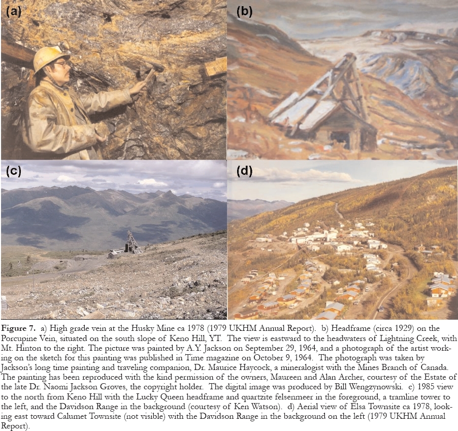
Production Summary
187 The final Mineral Inventory Report (Watson 1989a) showed that proven, probable and stockpiled reserves had increased by 69% during the final year, to 292,000 t at an average grade of 0.96 kg/t (28 oz/ton) Ag and 4.6% Pb, with a drop in Ag grade from the previous year of only 7.9%. The reserves were divided into: a) underground reserves of about 179,000 t grading 1.24 kg/t (36.2 oz/ton) Ag and 5.3% Pb, using a cut-off grade of 0.52 kg/t (15 oz/ton); and b) open-pit reserves of about 113,000 t with an average grade of 0.51 kg/t (14.9 oz/ton) Ag and 3.3% Pb, at a cutoff grade of 0.34 kg/t (10 oz/ton). Proven and accessible high-grade reserves, as well as considerable potential for additions, were present at the Bellekeno, Husky Southwest and Silver King mines.
188 The 1988 production was about 91,800 t of ore averaging 0.69 kg/t (20.1 oz/ton) Ag and 4.3% Pb, equal to 63.25 t (2.03 million oz) of Ag, of which 38% of the tonnes and 65% of the Ag came from underground. The mill feed came from six underground mines (Bellekeno, Silver King, Husky, Husky Southwest, Elsa and No Cash) and five open-pits (Onek, Calumet 1-15, Calumet 3-4, and Flame-Moth), and some Elsa mill tailings. At closure, UKHM owned virtually the entire camp. Its 947 claims, which included 676 surveyed 21-year leases and 2 Crown Grants, formed an almost contiguous block covering approximately 20,000 ha.
189 Total Ag production from the Keno Hill Camp was 6667.2 t (214.04 million oz) from 4847 million t of ore. The average grade of the ore was 1.373 kg/t (40.1 oz/ton) Ag, 6.7% Pb and 4.19% Zn (Watson 1989b). A detailed breakdown by mine is shown in Table 1. For comparison, the Cobalt camp, Ontario produced 11,350 t (365 million oz); the Slocan district (Kokanee Range), B.C. produced 1710 t (55 million oz); and the Coeur d'Alene district, Idaho produced about 31,100 t (1 billion oz) to the end of 1978 (Franzen 1979).
190 The Hector-Calumet mine produced 50.9% of the total, 45% of the Ag, 57.3% of the Pb and 76.6% of the Zn. If the Husky and Elsa mines are considered as two parts of the same deposit offset by a fault, as commonly believed, they account for 18.2% of the ore, 23.2% of the Ag, 11.8% of the Pb and 4.1% of the Zn. Therefore, the Hector-Calumet and Elsa-Husky mines produced between 68.2 and 69.1% of the Ag and the Pb, respectively, and 80.7% of the Zn from the entire camp.
191 It is difficult to pick one mine as the best or most important in the history of the camp because several played key roles at different times. A timeline of the Keno Hill Camp is shown in Table 2. Keno attracted the Guggenheims and focused international attention on the camp in the early 1900s. Sadie-Ladue justified the construction of the first mill, Lucky Queen was found just in time to keep the camp alive until the Great Depression, and Elsa permitted it to be reopened. After World War Two, Hector-Calumet was the powerful fly-wheel that generated the cash flow to fund the deeper exploration of the rest of the camp. Elsa was a rich plum that contained the best bonanza oreshoot, the 5 and 15 veins. And finally, Husky kept the camp alive after Hector Calumet closed. Silver King was the site of the initial discovery and production (in 1913) and was still in production at closure, albeit with several long interruptions.
Table 2. Timeline of the Keno Hill Camp
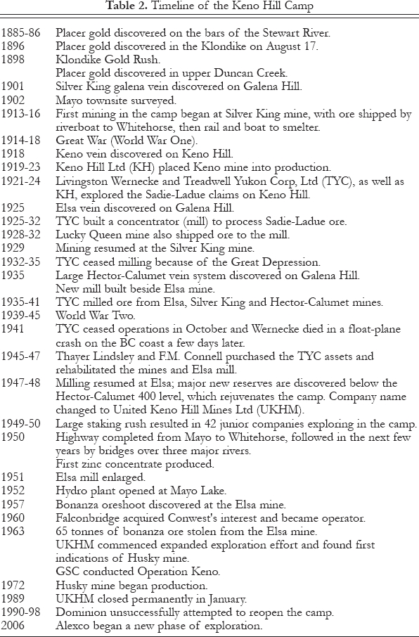
Post-1989
192 In July 1990, Falconbridge sold its controlling 32% interest in UKHM (subject to a net smelter return) and transferred its considerable reclamation obligations to a new junior company with the impressive name of The Dominion Mineral Resources and Sterling Frontier Properties Company of Canada Limited (Dominion), headed by Stephen Powell. Up to 1997, Dominion raised about $30 million and carried out surface and underground exploration under the direction of Toronto-based consultants Watts, Griffis & McQuat, as well as underground development and rehabilitation and preparation of a feasibility study by Rescan Engineering of Vancouver, plus permitting work, and environmental and site maintenance. Exploration at the Bellekeno, Husky Southwest, and Silver King mines reportedly increased the underground mineable resource to 425,000 t grading1.18 kg/t (34.5 oz/ton) Ag, 7.0% Pb, and 5.5% Zn.
193 Based on detailed mine planning and test stoping, Dominion planned to introduce a completely different mining technique to the camp, consisting of sub-level-retreat mining using both cut-and-fill and shrinkage methods, shotcrete for ground support, and trucking to surface via large (3.7 m by 4.9 m) haulage headings. Ore was to be drawn from lightly supported production headings in the footwall of the vein. Active workings were to be drained by pumping water from at least one level below. Dominion received a Type A Water License in January 1998 in preparation for a resumption of production but financing could not be obtained and it was never shown whether this technique was feasible. Since then, caving has seriously damaged a decline driven by Dominion at the Bellekeno mine, which means that new access will be required to that part of the deposit. After Dominion abandoned its rights, the property reverted to UKHM. Monthly overhead costs associated with environmental liabilities and maintenance of the surface facilities and underground workings soon drove UKHM into bankruptcy, and the Yukon Government inherited the assets.
194 Several other companies considered investing in Keno Hill. Advanced Mineral Technology (AMT) Canada Inc., which agreed to purchase the assets for $3.6 million in October 2001, was rumoured to be mainly interested in developing a flow-sheet to leach the remaining Ag content from the extensive Elsa mill tailings. These were estimated to contain a higher grade portion of about 920,000 t grading 0.18 kg/t (5.35 oz/ton) plus another 2,820,000 t averaging 0.08 kg/t (2.4 oz/ton). However, the agreement was never completed because of concern about the historical environmental liabilities. In May 2003, Nevada Pacific Gold Ltd. also decided not to proceed with an agreement, probably for the same reasons. Meanwhile, the Yukon government announced that the Nacho Nyak Dun First Nation would provide site care and maintenance, including water treatment facilities, site inspections and caretaking at an estimated cost of $70,000 per month.
195 In early 2006, Alexco Resources Corp, a new junior company, was selected from eleven bidders to purchase the assets. A subsidiary, Elsa Reclamation and Development Co. Ltd., (ERDC) purchased the assets for $410,000 and other considerations, including a $10 million environmental bond (Northern Miner, March 2, 2006). The major shareholders of Alexco are NovaGold Resources Inc. (19.3%), Quest Capital Corporation (9.9%), and ALM Group ULC. ERDC also announced it would team with ARCADIS G&M, Inc. in addressing the environmental issues. ARCADIS is described as a global engineering firm with extensive experience in North American remediation of contaminated sites. Alexco commenced a 15,000 m diamond drilling program in July.
IMPORTANCE OF THE KENO HILL CAMP
196 From an historical perspective, this paper describes a type of mining that has almost disappeared in Canada, consisting of labour-intensive underground vein mining, operation of company towns in remote areas, and pioneering in a vast region without any infrastructure. Because of remoteness and climate, Keno Hill residents were heavily dependent on one another for entertainment and support, and organized every type of community activity imaginable. Successful family life was impossible without a very strong spouse.
197 For a geologist, Keno Hill was like attending an elite graduate school because of the difficulty in finding small but rich deposits using surface exploration techniques, and following them underground. The results of careful observation, persistence and imagination were obvious and apparent to everyone on a daily basis.
198 Keno Hill was also a good example of how dependent a mining camp, even a rich one, is on metal prices, which leads to the inevitable "what ifs". If the camp had been situated closer to a smelter, tidewater, or the continental rail system, its transportation costs and cutoff grade would have been reduced substantially, thereby resulting in a significant increase in total production and probably a much longer life. In addition, a better location would have turned the Zn associated with the Ag-Pb ore into an asset throughout the life of the operation. If the camp had been found after the 1950s, when modern earthmoving equipment became available, much of the ore would have been mined by open-pits to depths of at least 50 to 100 m. That approach would have been even more advantageous at Keno Hill than elsewhere because of the extremely high underground costs. Also, if the camp was discovered today, the work-force would be bussed or flown in from Whitehorse and southern cities and the expense and headaches involved in operating a company town would not be an issue.
Infrastructure (including transportation)
199 The principal contribution of the Keno Hill Camp was certainly the impetus it provided for the construction of an all-weather highway from Whitehorse to Mayo and Dawson during the 1950s. Prior to that, it provided the extra traffic that was needed to support riverboat traffic on the Yukon River system after the decline of the Klondike goldfield, and it helped to keep the White Pass Railway alive until the mining boom that began in the 1960s. Keno Hill was also responsible for the installation of a hydroelectric dam and a manned airport at Mayo.
200 The conversion from horses to bulldozers for pulling winter freight trains, starting in 1922, and walking a bulldozer 400 km overland in the mountains without a road in 1924, were certainly pioneering ventures, in the northwest at least.
Environmental Measures
201 The Keno Hill Camp was developed before the modern era of environmental impact studies and social licenses, and the reclamation phase is quite incomplete. The Wernecke and Calumet town-sites have been removed and left in a tidy condition but the Elsa townsite has been maintained by a caretaker in case mining resumes. The Elsa mill tailings are not completely revegetated.
Geological Ideas and Exploration Innovations
202 In spite of discouragement when some of the earliest Ag-Pb deposits appeared to change into weak mineralization or turn into Zn deposits at shallow depths, the orebodies were gradually recognized as stacked ore shoots, each with a Ag-Pb-rich top and Zn-Fe-rich bottom.The orebodies were eventually mined to depths of up to 360 m but were generally not explored deeper, for economic rather than geologic reasons.
203 Several innovative exploration ideas were pioneered in the camp. Starting in the 1920s, prospectors adapted a prospecting technique used by Yukon placer Au miners, which consisted of sinking narrow shafts in frozen streambeds during winter to locate paystreaks lying on bedrock. The technique was found to be equally effective in searching for mineralized Ag veins buried under overburden and resulted in many discoveries.
204 The operation of an ambitious regional exploration program by TYC from 1929 to 1933, supported by float planes in a mountainous region with few lakes, unpredictable weather, poor radio communication, and minimal mapping, geological or otherwise, was a great pioneering accomplishment.
205 A program of rotary percussion drilling on a systematic grid pattern was introduced in 1963 to mechanize the shaft exploration approach and replace unreliable and more costly diamond drilling. Almost 600 km of holes were drilled to find and sample veins under shallow overburden. At the same time, it was shown that mineralized veins could be located with soil samples collected on a much wider spacing than was previously thought possible, and that the presence of anomalous haloes around veins could be detected by geo-chemically sampling drill holes, even where no mineralization was visible. Underground, the erratic distribution of mineralization and sudden changes from unusually rich ore to waste made it essential that mine geologists visit every production and exploration heading almost daily.
206 The successful application of geochemical exploration in the mine area led to Operation Keno in 1963, the first helicopter-supported reconnaissance stream and spring sampling conducted by the Geological Survey of Canada. It was centred on Keno Hill and covered 1900 sq km.
Economic Impact
207 The economic importance of the camp cannot be emphasized too strongly. The territorial economy had exploded suddenly because of the 1898 Gold Rush but then declined quickly within a decade as the exploration phase gave way to the dredging phase and the population began to dwindle. The traffic produced by the Keno Hill Camp following the First World War saved the Yukon River transportation system and the White Pass Railway. Except for military expenditures during the Second World War and federal government transfers, Keno Hill was the economic mainstay of Yukon Territory from the early 1920s until the early 1960s.
THE FUTURE
208 Although the Keno Hill Camp refuses to die, its future remains uncertain. As long as the federal and territorial governments are willing to fund a large part of the reclamation and remediation liabilities from the UKHM (Falconbridge) era, then the risk for a new investor will be significantly reduced. On the positive side, Ag prices have risen substantially in 2006, although the recent spike from $9.30 to 15.20 and back to 9.60 within six months suggests that the price is currently driven by speculation rather than market fundamentals. As shown in Figure 5, the price stayed near its long-term, inflation-adjusted, trend line between 1990 and the end of 2005, ending close to the level at which UKHM was forced to close down. Taking inflation into account, the price would have to rise to almost $60 to equal the previous high back in 1980.
209 On the negative side, labour and power costs are now much higher than when mining ended in January 1989 and the old mill and notoriously unstable mine workings have been sitting idle for 17 years. The former supply of European immigrants willing to work underground is a thing of the past and it is unlikely that many former employees familiar with the operation could be enticed back. A serious shortage of experienced miners throughout the major industrialized nations, in the midst of a global mining boom, will be a major challenge.
210 There is no argument that rich Ag-Pb vein mineralization remains in the Keno Hill Camp. All of the important mines either bottomed in good mineralization or in a strong vein that warranted deeper exploration. Who can say whether or not exploration a hundred m or more beneath the relatively shallow Sadie-Ladue, Lucky Queen, Silver King or Husky mines wouldn't encounter the Ag-rich top of another oreshoot, just at it did at the Hector-Calumet and Keno mines?
211 The challenge is finding a way to explore and mine economically at those depths. The economics of narrow underground vein mining in weak wall rocks that require expensive ground support currently discourages such an approach. The Keno Hill Camp has presented enormous development challenges throughout its history and will require the same bold and imaginative solutions if it is to have a future.
ACKNOWLEDGEMENTS
For their geological insights, recollections and interpretations, and reviews of early drafts, I am pleased to acknowledge the valuable input from former Chief Geologists Alan Archer, the very model of an observant mine geologist (1963 to 1965, following 5 years as a mine geologist); Jeff Franzen (1979 to 1983); and Ken Watson (1983 to 1989); as well as R.E. ‘Dutch' Van Tassell, Chief Exploration Geologist from 1963 to 1969 (and thereafter a consultant until 1982). I have relied, as well, on my own experience as UKHM's Chief Mine Geologist and Assistant Mine Superintendent between 1963 and the end of 1965. Lyn Bleiler, Ken Watson and Dutch Van Tassell kindly provided photographs and references, John Jambor was an invaluable consulting mineralo-gist, Dirk Tempelman-Kluit prepared most of the maps, and Ken Watson compiled the production table. Charlie Roots provided a digital version of the regional geology map (Fig. 2). In addition, external reviewers Craig Hart and Ian Jonasson made valuable suggestions for improving the text and Craig prepared Figure 5. The historical aspects of this paper has relied heavily on a 480-page, unpublished manuscript written prior to 1972 by Aaro Emil Aho, one of the best exploration geologists/entrepreneurs to ever set foot in the territory. (Part of the Aho manuscript referring to UKHM after the mid-1950s was actually written by Alan Archer.) Dr. Aho's manuscript was still incomplete at the time of his premature death in a farming accident in May 1977, at the age of 51. Fortunately, his family donated it to the Yukon Archives for safekeeping and an edited version was published in 2006. The Mayo Historical Society relied heavily on the Aho manuscript, as well as on government files, company records, and additional pioneer interviews in the preparation of its thorough and well-illustrated 1990 book ‘Gold and Galena'. Although he personally worked only on the periphery of the Keno Hill Camp, where he experienced the usual disappointments, frustrations, and irritations that are so much a part of exploration, Aho credited that experience for making him a more determined and tenacious explorer. He is best known for his leading role in the 1965 discovery of the Faro Zn-Pb-Ag mine in the Anvil camp, near Ross River, Yukon, by Dynasty Exploration Ltd., of which he was president. He followed that up with the discovery of the nearby Grum deposit for another company in 1973. In addition to his professional geological skill, Aaro Aho was a dedicated amateur historian with a keen interest in, and deep respect for, the people who had built the mining camp and its frontier society (particularly the Scandinavians!). In the course of his research for the manuscript, he interviewed more than a hundred of the pioneers who were still alive in the 1940s and 1950s, as well as members of the Wernecke and Schellinger families living in California.REFERENCES
Aho, A., 1972, Keno Hill: an era of individualism in Yukon's great silver district: Yukon Archives, Whitehorse, unpublished manuscript 82/161, 480 p.
Aho, A., 2006, Hills of silver: the Yukon's mighty Keno Hill Mine: Keller, B., ed., Harbour Publishing, Madeira Park, 336 p.
Beaudoin, G., and Sangster, D.F., 1992, A descriptive model for silver-lead-zinc veins in clastic metasedimentary terranes: Economic Geology, v. 87, p. 1005-1021.
Bleiler, L., Burn, C., and O'Donoghue, M., eds., Heart of the Yukon: a natural history of the Mayo area: Publisher, Village of Mayo, 138 p.
Blusson, S.L., 1978, Geologic setting of lead-zinc deposits in Selwyn Basin, Yukon, in Current Research, Part A: Geological Survey of Canada Paper 78-1A, p. 77-80.
Boyle, R.W., 1961, Native zinc at Keno Hill: The Canadian Mineralogist, v. 6, p. 692-694.
Boyle, R.W., 1965, Geology, geochemistry and origin of the lead-zinc-silver deposits of the Keno Hill - Galena Hill area, Yukon Territory: Geological Survey of Canada, Bulletin 111, 302 p.
Boyle, R.W., 1976, Native lead at Keno Hill, Yukon: The Canadian Mineralogist, v. 14,p. 577.
Boyle, R.W., 1979, The geochemistry of gold and its deposits: Geological Survey of Canada, Bulletin 280, 584 p.
Boyle, R.W., Wanless, R.K., and Stevens, R.D., 1970, Sulfur isotope investigation of the lead-zinc-silver-cadmium deposits of the Keno Hill - Galena Hill area, Yukon, Canada: Economic Geology, v. 65, p. 1-10.
Bradley, W., 1941, Memo to B. M. Co re Mayo Trip; unpublished report about a visit to the Keno Hill camp in August 1939 (dated September 29, 1941), Mayo Historical Society.
Carmichael, A.D. Jr., 1957, United Keno Hill Mines, in Gilbert, G., ed., Structural Geology of Canadian Ore Deposits, Congress Volume: Canadian Institute of Mining and Metallurgy, Geology Division, Mercury Press, Montreal, p. 66-77.
Cathro, R.J., 2006, Great mining camps of Canada: Announcing a new series: Geoscience Canada, v. 33, no. 2, p. 56-59.
Cockfield, W.E., 1921, Silver-lead deposits of the Keno Hill area, Mayo District, Yukon: Geological Survey of Canada, Summary Report, 1920, Part A, p. 1-6.
Franzen, J.P., 1979, Metal-ratio zonation in the Keno Hill District: unpublished paper presented at the Seventh Geoscience Forum, Whitehorse.
Fingler, J., 2005, Private geological report on the McQuesten Property for Alexco Resources Corp: published in the Alexco prospectus, available from [http://www.sedar.com/issuers/issuers_en.htm].
Hicks, H.B., 1949, The United Keno Hill Mine: Western Miner, November, p. 46-56.
Hicks, H.B., 1952, Exploration, development, and production practices at United Keno Hill Mines Ltd: Canadian Mining and Metallurgical Bulletin, v. 45, n. 486 (October), p. 587-597.
Hoyt, E.P. Jr., 1967, The Guggenheims and the American dream: Funk and Wagnalls, New York, 382 p.
Johnston, A.W., and Powelson, J.M., 1951, Development of Mayo Mining district, Mayo, Yukon Territory: Proceedings, Geological Association of Canada, v. 4,p. 41-48.
K-L Services, 2004, Exploring Keno Hill: stories of a Silver Deposit: Yukon Development Corporation, 25 p.
Lebarge, W.P., Bond, J.D., and Hein, F.J., 2002, Placer gold deposits of the Mayo area, central Yukon: Bulletin 13, Exploration and Geological Services Division, Yukon Region, Indian and Northern Affairs Canada, Ottawa.
Lynch, J.V.G., 1989, Large-scale hydrothermal zoning reflected in the tetrahedritefreibergite solid solution, Keno Hill Ag-Pb-Zn district, Yukon: Canadian Mineralogist, v. 27, p. 383-400.
MacDonald, L.E.T. and Bleiler, L.R., compilers, 1990, Gold and galena: a history of the Mayo district: Friesen Printers, Altona, Manitoba, 502 p.
Mair, J.L., Hart, C.J.R., and Stephens, J.R., 2006, Deformation history of the northwestern Selwyn Basin, Yukon, Canada: implications for orogen evolution and mid-Cretaceous magmatism: Geological Society of America, Bulletin, v. 118, p. 304-323.
Mortensen, J.K., and Thompson, R.I., 1990, A U-Pb zircon-baddeleyite age for a differentiated mafic sill in the Ogilvie Mountains, west-central Yukon Territory, in Radiogenic Age and Isotopic Studies, Report 3: Geological Survey of Canada, Paper 89-2, p. 23-28.
Murphy, D.C., 1997, Geology of the McQuesten River region, northern McQuesten and Mayo map areas, Yukon Territory (115P/14, 15, 16; 105M/13,14): Exploration and Geological Services Division, Yukon, Indian and Northern Affairs Canada, Bulletin 6, 112 p.
Roots, C.F., and Murphy, D.C., 1992, New developments in the geology of Mayo map area, Yukon Territory, in Current Research, Part A: Geological Survey of Canada, Paper 92-1A, p. 163-171.
Sack, R.O., Lynch, J.V.G., and Foit, Jr, F., 2003, Fahlore as a petrogenetic indicator, Keno Hill Ag-Pb-Zn district, Yukon, Canada: Mineralogical Magazine, v. 67, p. 1023-1038.
Sinclair, A.J., Tessari, O.J., and Harakal, J.E., 1980, Age of Ag-Pb-Zn mineralization, Keno Hill - Galena Hill area, Yukon Territory: Canadian Journal of Earth Sciences, v. 17, p. 1100-1103.
Stone, D., and Stone, B., 1983, Hard rock gold: the story of the great mines that were the heartbeat of Juneau, Alaska: Vanguard Press, Seattle, 108 p.
Tempelman-Kluit, D.J., 1970, The stratigraphy and structure of the "Keno Hill Quartzite"; in Tombstone River - Upper Klondike River map areas, Yukon Territory: Geological Survey of Canada, Bulletin 180, 102 p.
Tessari, O.J., 1979, Model ages and applied whole rock geochemistry of Ag-Pb-Zn veins, Keno Hill - Galena Hill mining camp, Yukon Territory: unpublished M. Sc. Thesis, University of British Columbia, xxx p.
UKHM Staff, 1961, Current operations at United Keno Hill Mines: Canadian Mining and Metallurgical Bulletin, v. 54, no. 594 (October), p. 722-739.
Van Tassell, R.E., 1969, Exploration by over-burden drilling at United Keno Hill Mines Ltd, in International Exploration Symposium: Colorado School of Mines Quarterly, v. 64, p. 457-478.
Watson, K.W., 1986, Ag-lead-zinc deposits of the Keno Hill - Galena Hill area, Yukon Territory: Yukon Geology, v. 1, p. 83-88.
Watson, K.W., 1989a, Operations overview, 1966-1987: a strategy for the future: unpublished company report, United Keno Hill Mines Ltd.
Watson, K.W., 1989b, Mineral inventory as of December 31, 1988: unpublished company report, United Keno Hill Mines Ltd.
Watson, K.W., 1989c, Total minehead production, Keno Hill - Galena Hill area, 1914 - 1989: unpublished company report, United Keno Hill Mines Ltd.
Watson, K.W., undated, Table of minerals identified from the Keno-Galena Hill area: unpublished company report, United Keno Hill Mines Ltd.
Wernecke, L., 1932, Glaciation, depth of permafrost, and ice veins of Keno Hill and vicinity, Yukon Territory: Engineering and Mining Journal, v. 133,p. 38-43.
Williams, C.F., 1922, The Mayo district in Yukon Territory: Engineering and Mining Journal-Press, v. 113 (June 17), p. 1039-1046.