Series
Geoscience of Climate and Energy 12.
Water Quality Issues in the Oil Sands Region of the Lower Athabasca River, Alberta 1
http://dx.doi.org/10.12789/geocanj.2013.40.012
SUMMARY
I summarize the controversies about industrial pollutants in freshwaters near the oil sands industrial area of Alberta, the inadequacies in environmental monitoring that have led to widespread misconceptions, and recent attempts to correct the problems. Adequate data are available to show that mercury, other trace metals, and polycyclic aromatic compounds are being added by industry to the Athabasca river system and its watershed, although the relative contributions of industrial development and natural sources remain in question. Recent improvements in water monitoring by Environment Canada show promise of resolving the controversies, although independent governance for Canada’s and Alberta’s water monitoring programs in the lower Athabasca River will be necessary to rebuild public confidence in the data and their interpretation by government and industry. I document one success story in the Athabasca River: the elimination of dioxins from pulp mills in the mid-1990s has caused a consumption advisory for fish in the river to be repealed.
SOMMAIRE
Je présente ci-dessous un résumé des controverses concernant les polluants industriels dans les eaux douces à proximité de la zone industrielle des sables bitumineux de l'Alberta, des lacunes dans la surveillance des milieux de vie à l’origine d’idées fausses répandues, et de récentes tentatives visant à corriger les problèmes. Des données adéquates démontrent que l’industrie ajoute du mercure et d'autres métaux traces ainsi que des composés aromatiques polycy-cliques dans le système fluvial de la rivière Athabasca et dans son bassin versant, bien que les contributions relatives provenant de ces activités indus-trielles et de sources naturelles demeurent toujours en litige. De récentes améliorations apportées au contrôle des eaux par Environnement Canada permettent d’espérer une résolution des controverses, mais l’application d’une gouvernance indépendante des programmes de contrôle de l'eau de l'Alberta du Canada dans la partie inférieure du fleuve Athabasca sera nécessaire pour rétablir la confiance de la population à l’égard des données présentées et de leur interprétation par le gouvernement et l'industrie. Je décrie l’histoire d’une intervention réussie dans la rivière Athabasca, soit l'élimination de dioxines provenant des usines de pâte du milieu des années 1990 et qui a abouti à l’abrogation d’un avis de limitation de la consommation de poisson dans la rivière.
INTRODUCTION
1 The purpose of this paper is to describe the state of water quality in the lower Athabasca River, how it has been affected by the oil sands industry, and what is necessary to improve our understanding of the present and future impacts of industry on the river. It complements the papers of Miall and Percy (this issue), who describe the geological basis of the oil sands industry, the manner in which the bitumen resource is exploited, and potential effects on groundwater and air quality in the area (Miall 2013a, b; Percy 2013).
2 As of 2013, the oil sands industry has been operating in Alberta for 46 years, and water quality monitoring has been ongoing for 38 years (Wallace 2011, 2013). Many millions of dollars have been spent by federal and provincial agencies and by industry under a variety of scientific programs. We still do not know the full impact of the oil sands industry on the water quality and biota of the Athabasca River and its tributaries. Even ‘hotspots’ for fish production, where damage to the river should be avoided at all costs during industrial development, are still unknown. This situation is all the more remarkable given the vital importance of oil sands extraction to the economies of the Province of Alberta and Canada, as a whole, and of the Athabasca River to thousands of indigenous people who live downstream of the development. Disagreements about the state of the river continue to cause a highly polarized debate between industry and government on one side, and indigenous people, some academics, and the international environmental community on the other.
A Brief History of Oil Sands Development and Monitoring Efforts on the Athabasca River
3 The Science and Industrial Research Council of Alberta (SIRCA, later to become the Alberta Research Council), was formed in 1921, and given primary responsibility for development of the oil sands. Dr. Karl Clark of SIRCA devised a method for large scale extraction of bitumen from the sands using sodium hydroxide and hot water, which has become the basic process for separating bitumen from sand in the deposits of the area described by Miall (2013a). Clark patented the process in 1929. Between 1930 and the late 1950s, large-scale extraction experiments were undertaken at a site on the Athabasca River called Bitu-mount, 89 km north of Fort McMurray (Humphries 2008). Bitumount is now a provincial historic site. The first large-scale industrial development occurred when the Great Canadian Oil Sands (later to become Suncor) began operating in 1967, producing 12,000 barrels of bitumen a day. It was followed by Syncrude, a consortium of several oil companies, plus the Canadian, Alberta and Ontario governments, in 1978 (Humphries 2008). There is no public record of any substantive concerns about effects on the environment during these early phases of development.
Alberta Oil Sands Environmental Research Program – The first regional scale oil sands monitoring program
4 Although the governments of Canada and Alberta initially recognized that a regional-scale baseline study was needed, concerns about damage to the aquatic environment began to increase soon after full-scale industrial activity began in the 1980s, following a number of poorly documented spills of bitumen or of water used for bitumen extraction (summarized by Timoney and Lee 2009) into the river in the 1970s and early 1980s. In 1975, monitoring of the Athabasca River and its tributaries in the oil sands region was begun under the Alberta Oil Sands Environmental Research Program (AOSERP), a federal–provincial cooperative program. AOSERP produced approximately 200 peer-reviewed reports and publications (Smith 1981), but repeated disagreements between federal and provincial governments caused the program agreement first to be renegotiated in 1977, then subsequently abandoned in 1980 when Canada unilaterally withdrew from the program, leaving regional oil sands monitoring largely in provincial hands (Wallace 2011). AOSERP produced some thorough pre-impact studies of the biology of the Athabasca River and several tributaries important to the regional fishery, but quantitative chemical methods of the day were not capable of giving reliable values for many of the hydrocarbon-based pollutants such as polycyclic aromatic compounds and toxic trace metals that are of concern today because they are toxic at µg/L or even ng/L.
5 Monitoring of water quality and biota during the 1980s was haphazard. Lacking scientific capacity, the Alberta government contracted consultants to perform environmental assessments. Some of these firms did excellent work, while others were of questionable value. Much of the work was poorly designed, and little of it was published in easily accessible form. During this period, synthetic crude oil production costs approached $20 per barrel, equal to or less than the market price of oil at the time (Humphries 2008). As a result, there was little interest in expanding the industry, and funding for environmental monitoring was very low. A ‘snapshot’ of the state of fisheries in the river during this early period was written by Wallace and McCart (1984), who published a rare compilation of the regional fishery data then known.
6 Concerns about the oil sands industry’s effects on water quality and fish in the Athabasca River increased following a January, 1982, fire at the Suncor plant that caused a catastrophic release of 50 tonnes of ‘oil and grease’ to the river (Birkholz et al. 1987). Among compounds known to have entered the river were raw naphtha, alkylated benzenes, benzothiophenes, and dibenzothiophenes. Many other organic compounds were tentatively identified, but not confirmed or quantified (Birkholz et al. 1987). The oil slick containing the contaminants was slowly swept downstream under ice, eventually entering Lake Athabasca, where it caused the commercial fishery to be closed (Timoney and Lee 2009). After this incident, complaints by indigenous people about malformed fish, and fish with flesh that did not appear or taste natural became very common. Specimens of malformed or tainted fish were sent to provincial officials, but no action was taken. The incident resulted in a lengthy, but ultimately successful, trial and prosecution under the Canada Fisheries Act against Suncor who staunchly defended its actions. If nothing else, this trial demonstrated the difficulties of presenting highly technical methodologies and quantitative analyses in court actions brought under the ‘deleterious’ provisions of the Act. During this period, reliable analyses for nutrients, some of the major cations and anions, total solids, and conductivity were performed on the river, which have proven useful for recent trend analyses (Squires et al. 2010; Dubé and Wilson 2013).
The Northern River Basins and Northern Rivers Ecosystem Initiative
7 In the early 1990s, the discovery of high dioxin and furan concentrations in fish near pulp mills that used chlorine to bleach paper pulp caused Alberta Health to issue consumption advisories for several hundred kilometres of the Athabasca and Peace rivers. A detailed study of the two rivers was undertaken by federal, territorial and provincial governments under the Northern River Basins Study (NRBS) in 1991–1996 (NRBS 1996; Wallace 2011, 2013). Although much of the focus of the NRBS was on upstream reaches where dioxins were released by pulp mills, some chemical contaminant work was completed in the oil sands area. It is noteworthy that low levels of contaminants with pulp mill signatures were found as far downstream as Lake Athabasca (Carey et al. 1996). At the time, there was still little increase in industrial activity in the oil sands, a result of continued low oil prices and high production costs.
8 Widespread concerns about health effects on indigenous people in the lower Athabasca region caused the final NRBS report (NRBS 1996) to recommend a thorough health study in the northern river basins. Meanwhile, changes to federal regulations caused all pulp mills to substitute chlorine dioxide for free chlorine in bleaching paper pulp, largely eliminating production of dioxins and furans. The recommended health study in the region was not done. After dioxins and furans were eliminated from mill effluents, concentrations in fish slowly declined (McMaster et al. 2006), allowing the repeal of consumption advisories in the early 2000s. The NRBS program was very popular with stake-holders in the basin, because all sectors of society, including indigenous people, had direct input to an independent, transparent decision-making agency with a strong scientific advisory board consisting of several reputable independent scientists, led by Dr. Peter Larkin. In addition, the results of monitoring studies were made quickly available to stakeholders. But, as in the case of AOSERP, disagreements between federal and provincial governments apparently led to the abandonment of the NRBS, with little attention paid to the detailed recommendations made at the end of the study that called for basin-scale scientific monitoring with significant involvement of local and Aboriginal peoples. A follow up study, called the Northern Rivers Ecosystem Initiative (NREI) in 1998–2004, was technically directed by the same three levels of government as the NRBS, but the program was executed almost entirely by federal scientists, i.e., without either an independent board or scientific oversight panel. While ongoing results of the NREI were not made readily available to the public, a CD-ROM can be obtained that has major findings and a series of papers summarizing various parts of the study appeared in the journal Environmental Monitoring and Assessment (Gummer et al. 2006).
9 In the later years of the NRBS/NREI studies, oil prices began to increase, stimulating rapid new development in the oil sands. Investment in the oil sands increased from $490 million in 1991 to over $20 billion in 2008 (Wallace 2011), and production of synthetic crude increased at an average of 7.5% per year (Schindler 2010). Unfortunately, during this period of intense and rapid development, major cuts were made to monitoring by both Environment Canada and Alberta Environment as the result of federal and provincial budget deficits. As a result, monitoring could not and did not keep pace with oil sands development.
The Regional Aquatic Monitoring Program
10 In 1997, the Regional Aquatic Monitoring Program (RAMP) was initiated by the oil sands industry. RAMP was intended to be directed by a multi-stakeholder group, but it soon became dominated by representatives from industry and government. Furthermore, RAMP was effectively made a part of the terms and conditions issued by the Government of Alberta to oil sands operators that effectively directed that the monitoring was to be done by the industry. As such, it became an inescapable part of the monitoring protocols for the oil sands region – all without external scientific reviews or critiques from internationally accredited scientific panels. Disillusioned First Nations and non-government organizations (NGOs) eventually quit the RAMP process. In January 2013, 18 industries, seven government agencies, two First Nations and no NGOs were listed as members of RAMP. RAMP was the subject of a scathing review by federal scientists in 2004 (Ayles et al. 2004), but the review was not released publicly. A second review in 2010 was also very critical of the monitoring program (RAMP Review Panel 2011). Astonishingly, RAMP’s data were not publicly available until 2010. As the result of changes in sampling times, stations, methods, protocols and chemical analyses, it is difficult to extract meaningful long-term trends from the RAMP data base.
11 The concerns of indigenous people were amplified by collaboration with environmental groups after 2000. Facilitated by modern electronic communications, they produced and disseminated numerous reports documenting environmental damage. Few were published in peer-reviewed science journals, although some provide excellent summaries. They were countered by a well-funded publicity campaign by the oil sands industry and the Alberta government. Incredibly, even further cuts were made to federal and provincial monitoring of Alberta river basins in the oil sands development region. The large and rapidly growing areas disturbed by mines, tailings ponds and in situ facilities, and increasing greenhouse gas emissions eventually sparked international concern. The situation was heightened by the unintended death of 1600 ducks in a Syn-crude tailings pond, where they landed into the surface oils during a spring snowstorm in early 2008. Following a highly publicized trial, hotly contested by Syncrude, that attracted international media attention, the corporation was convicted and paid $3 million in fines and penalties for not properly operating its waterfowl deterrent system in the oil sands area. Public relations efforts by industry and government were redoubled, to counter an increasing perception, propagated by some NGOs and international media coverage of the Syncrude trial, that oil sands produced ‘dirty oil.’ Indeed, the duck incident became a highly recognizable ‘touchstone’ press issue pursued by international NGOs who achieved their goal of awakening international public attention of the environmental costs of Canadian oil sands mining operations. The controversy has been exacerbated by the shortage of sound, comprehensive and transparent scientific monitoring (Commissioner of the Environment and Sustainable Development 2012).
12 The publicized official view of industry and government until very recently was that any pollutants in the river system were from erosion of natural bitumen deposits. This view was in part supported by older peer-reviewed scientific publications, most of them based on data collected in the 1990s, before the major expansion in the oil sands began.
Recent studies
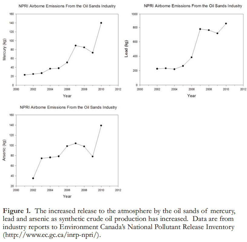
13 A 2005 spill of bunker C oil (a heavy fuel residual of refining) into Lake Wabamun, west of Edmonton, AB, caused several scientists to make comparisons of pollutant concentrations in that lake with the waters of the oil sands area, and with the Gulf of Alaska following the Exxon Valdez oil spill on 24 March 1989. These comparisons caused renewed concerns about the state of the lower Athabasca River. In particular, two large “upgraders” for converting bitumen to synthetic crude oil were known to burn ‘petcoke’ manufactured from mined bitumen, and to emit large and increasing quantities of toxic metals and organic pollutants to the air (Fig. 1). Although emissions of many toxins to the air were reported by industry to the National Pollutant Release Inventory, deposition of these substances in the area was not monitored, although deposition of toxins emitted from burning fossil fuels and smelting over broad landscapes is well known (Schindler et al. 1981). Also, numerous studies of the impacts of denuding watersheds of vegetation in other areas suggested that chemicals in runoff should be increasing as the result of oil sands development, despite claims to the contrary by industry and government. In a study of analogous landscape disturbance for mountain-top coal mining, Bernhardt et al. (2012) found detectable increases in chemical outputs and effects on stream benthos whenever disturbance affected more than five percent of a watershed’s surface area.
 Display large image of Figure 1
14 As a result, a small group of scientists decided to conduct our own study. We developed a detailed GIS-based study plan based on the geology of the area to compare concentrations of contaminants in reaches of the lower Athabasca River and its tributaries that were in a natural state with those where industrial development had occurred. We also examined deposition of contaminants in snow in the 2007–2008 winter season. We found clear evidence of release and re-deposition of both polycyclic aromatic compounds and toxic elements in snow, to a distance of 50 km or more around the oil sands industrial area. Based on deposition patterns, it appeared that the upgraders were the major sources of contaminants to air (Kelly et al. 2009, 2010). River reaches downstream of intense industrial activity generally also contained higher concentrations of contaminants than in less impacted reaches. Although there were few incidences where guidelines set by the Canadian Council of Ministers of the Environment (CCME) were exceeded (Kelly et al. 2009, 2010), the studies provided the first definitive evidence that industrial releases were adding to the natural contaminant burden in the region.
15 Our studies were first discounted by both provincial and federal government officials, but two prominent politicians chose a more prudent approach. Federal Minister of Environment Jim Prentice arranged a personal meeting to discuss our findings. Alberta Premier Ed Stelmach pointed out that our group had been right in several earlier studies, and ordered his officials to have our results considered more carefully. As a result, the two levels of government formed separate review panels of well-known scientists to examine our results and those of the RAMP and other provincial monitoring programs.
16 The federal Oil Sands Advisory Panel reported first and, based on our studies, recommended that monitoring in the Athabasca River and its tributaries needed to be upgraded significantly (Environment Canada 2010; Miall 2013a). As a result, Environment Canada assembled a panel of experts to help re-design its monitoring program (Environment Canada 2011). Other reports, by the Royal Society of Canada Expert Panel (2010), the Province of Alberta Expert Panel (WMDRC 2011) and the federal Commissioner of the Environment and Sustainable Development (2010) reinforced the conclusion that monitoring of the river was in urgent need of enhancement and improved scientific rigour. As a result, the Alberta Minister of Environment appointed yet another panel, the Alberta Environmental Monitoring Panel (AEMP), co-chaired by Dr. Howard Tennant and Mr. Hal Kvisle, which was instructed to develop a ‘world class’ monitoring program for the river. The AEMP report, released in June 2011 (AEMP 2011), noted that the conflicting roles of provincial and federal governments as both promoters and regulators of the oil sands had eroded public trust. They recommended “an Alberta Environmental Monitoring Commission to operate at arm’s length from government, regulators and those being regulated.” In February of 2012, a subsequent Alberta Environmental Monitoring Working Group (AEMWG) chaired by Dr. Ron Wallace was appointed by the Alberta Minister of Environment and Water to flesh out the AEMP recommendations. Following a 2012 provincial election, Minister McQueen of a newly amalgamated department of Environment and Sustainable Resource Development in October 2012, appointed a new Alberta Environmental Monitoring Management Board (AEMMB) chaired by Dr. Tennant to recommend funding mechanisms and the structure of the independent regulator recommended by the AEMP and the AEMWG. These latter activities are still under way with final results expected by summer, 2013.
Cumulative Effects Assessment
17 One frequent criticism of aquatic monitoring in the oil sands region is that true cumulative effects studies have not been done. Several recent studies have attempted to do so, but have been hampered by the inadequacies in the publicly available data, for reasons outlined above. Squires et al. (2010) and Dubé and Wilson (2013) examined the few reliable long-term data for the river. They found that long-term increases in total phosphorus, conductivity, sulphate and total dissolved nitrogen have occurred in the lower Athabasca River during the period of record, but it is not clear how much of the increases were caused by climate change vs industrial or other human activity. It seems likely that sewage releases from municipalities in the watershed, most notably Fort McMurray (population over 73,000 and growing rapidly), are one important source of phosphorus. Work camps on new oil sands sites under construction contain another 40,000 people. Also, pulp mills in the basin now add nutrients to their effluents to promote removal of biological oxygen demand and decomposition of undesirable chemicals. Because the river is enclosed by ice and snow for about 5 months of the year with low flow volume, oxygen depletion is of some concern for fish populations.
18 The extent that oil sands pollutants have harmed the mainstream Athabasca River remains controversial, but appears to be low, except for the few instances described below. However, continued rapid expansion is predicted to double the impact of the industry in the next 10 years, and the lack of reliable baseline data causes continued concerns. Recent improvements in monitoring are rapidly resolving some of the issues. Given the huge deficiencies in past monitoring described above, paleolimnology will be needed to provide a temporal and spatial record of patterns of past contaminant dispersion in the oil sands region, as exemplified by Kurek et al. (2013), discussed later.
THE CURRENT STATE OF THE ATHABASCA RIVER
19 While few results from the upgraded monitoring program are available, I summarize some areas of known concern with respect to toxic substances in the Athabasca River system.
Mercury
20 Mercury in fish of the Athabasca River is a recognized threat to subsistence consumers. Studies as early as 1975 by Environment Canada showed that mercury in predatory fish of the river and adjacent Lake Athabasca was high even before major oil sands development. Donald et al. (1996) found that 25% of walleye Sander vitreus exceeded consumption guidelines for subsistence consumers, causing Alberta Health to issue a consumption advisory for the species. It is currently recommended that pregnant or nursing women eat no more than 150 g a month, children 1–4 eat less than 75 g a month, and that adults eat no more than 75 g per week of walleye, where 75 g is regarded as an average meal. A recent (2008) data set shows that consumption of northern pike Esox lucius and goldeye Hiodon alosoides should probably be similarly restricted, because the proportion of walleye, goldeye, and northern pike exceeding previous consumption guidelines for subsistence users (0.2 µg/g) was 80%, 72%, and 75%, respectively (Radmanovich 2013). At this point it is not clear whether the higher recent incidence of mercury exceedances for walleye than reported by Donald et al. (1996) is a real increase, or an artifact of methodology. It is under investigation. Fortunately, mercury in the most frequently eaten species, lake whitefish, Coregonus clupeaformis, remains well below consumption guidelines for subsistence users.
21 It is clear that mercury input to the area has increased due to the oil sands industry. The National Pollutant Release Inventory (NPRI) shows a seven-fold increase in upgrader emissions between 2001 and 2010, and mercury concentrations in snow averaged 5.5 fold higher within 50 km of upgraders than it did beyond that radius in 2008 (Kelly et al. 2010; Kirk et al. 2012). Mercury was also significantly higher in river water near or downstream of development, in both tributaries and the Athabasca main-stem, and in invertebrates and fish near to or downstream of development (Kelly et al. 2009; Radmanowich 2013). It is, however, noteworthy that even the most recent reported releases from oil sands upgraders appear not to be as high as from coal-fired power plants near Wabamun Lake, Alberta, (387–732 kg/a from 2000 to 2010) or near the base-metal smelter near Flin Flon, Manitoba, where almost 20 000 kg/a of mercury were emitted before the smelter was closed (CTV News Release, June 18 2010: http://winnipeg.ctvnews.ca/flin-flon-smelting-plant-closure-affects-residents-jobs-and-air-quality-1.524125).
22 The extent to which the oil sands industrial emissions have contributed to increased mercury in fish of the Athabasca River is not clear. Timoney and Lee (2009) analyzed three earlier studies, and reported increases in mercury in walleye from 0.32 µg/g in 1975 to 0.36 µg/g in 1992, then to 0.41 µg/g in 2005. This conclusion was disputed by Evans and Talbot (2012), who pointed out discrepancies in methods between earlier studies. Evans and Talbot (2012) examined more data sets, including RAMP’s, concluding that there was no significant change in mercury over time, but many small sample sizes, inconsistencies in sampling and analytical protocols between different studies also hindered their analysis. However, Radmanowich (2013) found a mean of only 0.36 µg/g in 20 walleye collected in 2008.
23 Hebert et al. (2011) found that mercury in tern eggs collected on islands near the Athabasca River’s mouth in Lake Athabasca contained 40% higher mercury in 2005 than in 1977. The 2005 eggs also contained high concentrations of naphthalene, which suggests that the source is connected with industrial oil sands development. It seems unlikely that mercury would increase in fish-eating birds if it did not also increase in the fish that birds fed upon. Until results from more comprehensive monitoring are available, the extent to which industrial input has contributed to elevated mercury in fish of the area remains controversial. It is, however, clear that concentrations of mercury in at least three species of fish frequently consumed by First Nations are high enough to warrant concern about subsistence of indigenous people in the area.
24 Despite elevated deposition near the upgraders, less than 4% of mercury emissions reported by NPRI can be accounted for within 50 km of the plant (Kelly et al. 2010). It is well known that long-range transport in the atmosphere causes global dispersal of mercury, and that human activities have increased the global background in the atmosphere by about threefold, with about equal thirds from natural sources, re-emissions of mercury mobilized by humans in earlier times, and annual direct emissions (http://www.epa.gov/hg/control_emis sions/global.htm). Global sources of mercury are still increasing rapidly, particularly in Asia, leading to recent calls for an international treaty to limit emissions (Qiu 2013), which was signed in February 2013.
25 Studies elsewhere have indicated that increasing airborne inputs of mercury will significantly increase concentrations in fish. In a whole water-shed experiment known as METAALICUS, Harris et al. (2007) added a small amount of a distinct stable isotope of mercury to a small lake at the Experimental Lakes Area, northwestern Ontario. The added isotope was reflected in concentrations in fish within a few months. Rapid transfer in the food chain was confirmed by mesocosm experiments in another lake (Orihel et al. 2007). Other distinctive isotopes of the mercury were added to wetlands and uplands in the lake’s catchment. Leakage from wetlands to the lake were very slow, and those from uplands undetectable, although upland mercury has been found to be mobilized during forest fires, which on average only occur once in several decades (Kelly et al. 2006). More recent data from METAALICUS have shown that once mercury inputs to an ecosystem are reduced, concentrations in fish also decrease rapidly, suggesting that the biogeochemical cycle of mercury in aquatic systems is dominated by the past few years of input (J.W.M. Rudd, pers. comm. November 2012). This further suggests that reducing atmospheric mercury will have rapid benefits for fisheries in the Athabasca River, but it is unclear whether reductions must go beyond the oil sands industry. To add to the concern in the oil sands region, Kirk et al. (2012) indicated that part of the particulate-bound mercury in snow of the area is already in methyl mercury form, making it highly susceptible to biological uptake immediately on entering lakes and rivers.
Organochlorine Pollutants – A Success Story in Pollutant Regulation
26 Polychlorinated dioxins and furans (PCDDs and PCDFs) were discovered to be unwanted by-products of using chlorine to bleach paper pulp in the 1980s. The compounds biomagnify in food chains, so that even small amounts in water can result in high concentrations in predatory fish. Concentrations in predatory fish in some reaches of the Athabasca River were high enough that a consumption advisory was issued for several species in the early 1990s. Following new federal regulations in 1992 that required pulp mills to use chlorine dioxide instead of free chlorine for bleaching, concentrations in fish of the Athabasca River began to decline. As a result, dioxins and furans have now declined to values where consumption advisories for fish have been lifted (McMaster et al. 2006).
27 One surprise finding from the NRBS studies was that polychlorinated biphenyls (PCBs) were also elevated near several pulp mill sites. In the nearby Wapiti River, a tributary to the Peace River, a pulp mill was identified as the source of PCBs, but on the Athabasca River, the combined municipal sewage/mill effluent at the town of Hinton, AB, added little to high concentrations found upstream of the effluent, and the source is not known. Concentrations of PCBs did not decline during the NRBS/NREI studies, and remain an issue of concern, although as of 2004, concentrations did not exceed guidelines in any area (McMaster et al. 2006). As in the case of dioxins and furans, biomagnification in food chains can result in high concentrations of PCBs in fish. Several widespread organochlorine pesticides, including toxaphene and DDT, have also been detected in fish, but in trace quantities (McMaster et al. 2006).
Polycyclic Aromatic Compounds
28 Polycyclic aromatic compounds (PACs) are currently one of the greatest concerns for chronic pollution in the oil sands, given their prominence in bitumen. The chemistry and toxicity of most PACs is poorly known, and there are hundreds of such compounds formed in both biomass burning and fossil fuel production and consumption. Most familiar are the polycyclic aromatic hydrocarbons (PAHs). A number of well-studied PAH congeners are on the US Environmental Protection Agency’s (EPA) priority pollutant list, because they have carcinogenic, mutagenic or teratogenic properties, cause immunosuppression, and cause a number of other health effects in animal populations (US EPA Fact Sheet: http://www.epa.gov/osw/hazard/wastemin/minimize/factshts/pahs .pdf). The toxicity of most other congeners, and related alkylated PAHs and dibenzothiophenes, both common in oil sands, is unknown. In the oil sands, alkylated PAHs are most prevalent, and the toxicity of this group is particularly poorly known, especially their carcinogenicity to humans (Baird et al. 2007). Also very common in the area and poorly understood are dibenzothiophenes, which have some sulphur atoms within their aromatic structure. Some PACs have been implicated in impairing the cardiac development of fish embryos, as well as a variety of morphological effects and impaired swimming performance (Incardona et al. 2004, 2011; Hicken et al. 2011). Canadian Water Quality Guidelines do not provide guidelines for alkylated PAHs in sediments (CCME 1999).
29 In many boreal areas, including the oil sands, pyrogenic sources (forest fires, products of internal combustion engines, etc.) are difficult to separate from petrogenic (originating in fossil fuels) sources. Most often, values for all congeners are simply summed and reported as ‘Total PAHs.’ Few individual compounds have been tested, despite their having a considerable range of toxicities (Incardona et al. 2004). As a result, it is difficult to make comparisons between sites with different mixtures of compounds, and statements like “total PAHs are higher in urban areas than in the oil sands,” which are popular with industry propagandists, can be highly misleading. Badly needed are studies of the toxicity of single polycyclic compounds, and known mixtures that represent the sources of concern (Baird et al. 2007).
30 We (Kelly et al. 2009) found that PACs, predominantly alkylated PAHs and dibenzothiophenes, were detectable in snow near industrial oil sands development, with concentrations highest near the upgraders that use coke as a fuel. Airborne emissions probably represent a combination of compounds formed in combustion of coke (which is produced on site from bitumen) and chemicals in raw bitumen that are volatile at the high temperatures used to upgrade the bitumen. Concentrations above background values were found in snow for a 50 km radius around the major upgraders near sampling site AR6 (Kelly et al. 2009), with the greatest proportion in particulate, rather than dissolved form. We also found that concentrations of PACs in the Athabasca River and its tributaries were higher near to or downstream of industrial development, including watershed disturbances (Kelly et al. 2009).
31 In lakes isolated from the river system, the degree of industrial contamination has been easy to determine, once sufficiently comprehensive studies were undertaken. Using paleolimnological methods Kurek et al. (2013) studied the long-term record of PAC contaminants in dated sediment cores from six lakes at varying distance from the oil sands upgraders. The six study lakes were in undisturbed, isolated basins, so that the only possible source of increasing contaminants was from airborne industrial emissions. The authors used a multiple chemical ‘fingerprinting’ technique to distinguish petrogenic industrial sources from natural pyrogenic sources such as forest fires. They found that industrial oil sands sources were responsible for increasing concentrations of PACs in sediments in lakes up to 95 km from sources, beginning with development of the oil sands industry. Only one lake had PAC concentrations of concern at present, although with projected rates of oil sands expansion, some have expressed concern that PAC concentrations may be reached in sediments that could exceed guidelines set by the Canadian Council of Ministers of Environment (Hodson 2013). This possibility must be more thoroughly examined. There was no indication of increased toxicity to Daphnia in the fossil record (at least to date), likely due to the greater influence of recent climate change on lake primary production of algae (the food resource of Daphnia). Jautzy et al. (2013) reported similar conclusions on the extent and source of PAH contamination.
32 PACs are generally hydrophobic, and those with lower molecular weights tend to be acutely toxic because of their higher water solubility. Their concentrations dissolved in water remain very low, seldom over a few parts per billion for individual congeners, even when input of PACs to the ecosystem is quite high. PACs in solution quickly attach to organic particles. The result has been public confusion caused in part by industry reporting that dissolved concentrations of PACs are very low, not mentioning that 90% and more of the compounds are in the suspended particulate fraction. As a result of their hydrophobic nature, toxicity of PACs to aquatic organisms is often seen first in species that are in contact with bottom sediments, such as the eggs and embryos of fish, and benthic insects, crustaceans and molluscs.
33 While it is widely agreed that erosion of natural bituminous out-crops has been an important source of PACs to sediments of the Athabasca River, some studies have concluded that industrial development has caused significant increases in PAC concentrations in river sediments (Timoney and Lee 2011), while others have concluded the opposite (Hall et al. 2012). However, the latter study was based on the paleolimnology of two lakes well outside the known range of contamination by atmospheric emissions from oil sands sources, and with a variable history of connection to the river. Another problem with detecting increases in contaminants from industrial sources is that the contaminated sediments in rivers are usually deposited in fairly localized areas. If those depositional areas are frequently used by fish, a ‘hotspot’ for contaminant impact occurs (Choy et al. 2008; Fowlie et al. 2008). Unfortunately, due to inadequate monitoring, in the Athabasca River the correspondence between depositional areas for contaminants and fish habitat is still poorly known. Older studies show that concentrations of contaminants in tributary sediments are much higher than in the main stem Athabasca River, which is not surprising given the large upstream areas of the main stem where sediments are not from petroliferous deposits (Headley et al. 2001). Tributaries are key regional fishery spawning areas (Bond and Machniak 1979; Machniak and Bond 1979) and also the areas where water-shed disturbance from mining is highest, making them the most likely sites of industrially caused biological effects. In this regard, studies of fish embryos lead to some interesting hypotheses. It sometimes seems forgotten that the larger tributaries are important sources of fish to the entire Athabasca system, rather than just conduits for water and pollutants. Several thousand fish per year use each of the larger tributaries in the oil sands area (Bond and Mach-niak 1979; Machniak and Bond 1979). As for mercury, resolution of the degree of industrial contribution and its effect on biota must await more detailed study.
Other Pollutants of Concern
34 Several other trace metals are high enough to be of concern in the oil sands area. These include zinc, lead, arsenic copper, cadmium, thallium and vanadium. All are present in bitumen, and all are released in increasing amounts from upgrader emissions (Kelly et al. 2010). However, at present, not enough is known of natural sources or concentrations in biota to indicate whether increased industrial activity will cause problems in the near future. Also of concern is that it is not known whether chronic exposure to the ‘cocktail’ of low concentrations of organic and inorganic contaminants represented by waters in the oil sands area is harmful to fish or other organisms. Hopefully, the proposed improved monitoring program will yield such information quickly.
35 Concerns have been expressed about naphthenic acids (Lo et al. 2006), which are very high in water used for oil sands extraction, and are acutely toxic. Concentrations of concern are not reached outside of tailings ponds, as would be expected from low rates of seepage (Miall 2013b). The main concern would be for a large release to the river, as described below.
Effects of Pollutants on Fish and Benthos
36 Several species of fish in the Athabasca River and western Lake Athabasca have high incidences of malformations, including tumours, hematomas, mouth and eye defects, and spinal abnormalities. RAMP has reportedly observed that from 2 to 7 percent of its annual catch has displayed malformations, growths or diseases since 1997 (Globe and Mail News Release, December 2010: http://www.theglobeandmail.com/news/politics/ottawa-kept-in-dark-on-abnormal-fish-found-in-oil-sands-rivers/article1320694/), an incidence reminiscent of industrially contaminated sites in the lower Great Lakes (Smith et al. 1994; Baumann et al. 2000). Indigenous fishermen say that such malformations did not exist in the Athabasca River before the 1980s. This claim receives support from McCart et al. (1982), who examined over 19,000 lake whitefish in the river in 1980, reporting no incidence of malformations, despite one purpose of their study being to record evidence of fish disease (P. McCart, pers. comm. November 2012). Similarly, there is no mention of malformations in reports from AOSERP studies in the late 1970s, where thousands of fish were handled through fish counting fences on tributaries by experienced fisheries biologists. I have personally caught several hundred lake trout, pike and walleye in central Lake Athabasca and interviewed several long-term fishing guides. There is no evidence of malformations or growths except in the western end of the lake near the mouth of the Athabasca River.
37 It is likely that the malformations observed in adult fish developed when fish were in embryonic stages. Colavecchia et al. (2004, 2006, 2007) found a high incidence of mortality in embryos of fathead minnows Pimephales promelas and white sucker Catostomus commersoni hatched in the laboratory on sediments rich in oil sands bitumen. Among surviving embryos, a high proportion were malformed, with deformities similar to those found in adult fish from the system. It has generally been assumed that impaired growth and swimming ability will cause decreased probability of survival of embryos, but enough may reach adulthood to be caught by human users.
38 After hatching upstream of Fort McMurray or in suitable tributary reaches, fingerling whitefish and gold-eye migrate downstream to Lake Athabasca, where they do most of their feeding and growing in the lake environment (McCart et al. 1982). It is conceivable that the malformed adult fish do not contain high levels of industrial contaminants, but their grotesque appearance leads indigenous people to avoid eating them.
39 A similar broad range of malformations has been observed in fish of the Gulf of Mexico following the Deepwater Horizon oil spill. A wide variety of laboratory studies suggest that the mechanism may be immune system depression following exposure to PAHs, which leaves fish open to a wide variety of waterborne diseases, of bacterial, fungal and viral origins (James H. Cowan Jr., pers. comm. 5 April 2013).
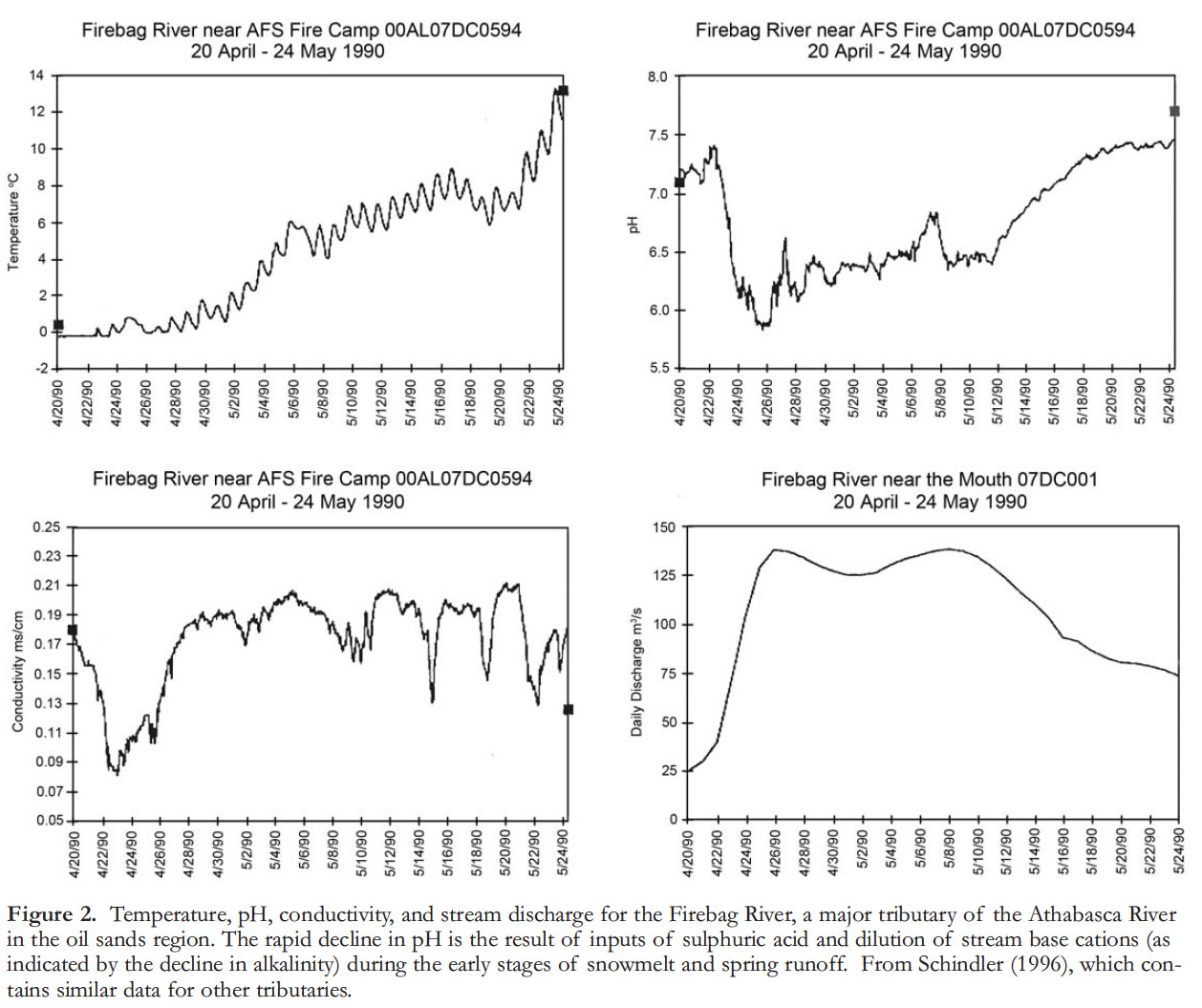
40 At present, data on fish populations in the Athabasca River and its tributaries are not thorough enough to be able to tell whether there have been long-term declines in fish habitat and production, let alone whether pollutants have caused population-level effects. One period of particular concern is during spring snowmelt, when acids and toxins accumulated for 4–5 months are flushed into tributaries within a few weeks. Melting snow is known to be low in conductivity because of low base cation concentrations, but, industrial emissions can contaminate it with high concentrations of strong acids and toxins (Schindler et al. 1981). The combination of dilution (which probably varies considerably, based on snowpack and speed of melting) and high hydrogen ion input leads to significant acid pulses (Galloway et al. 1987). While data for the oil sands region are few, significant pH depressions of up to two units were recorded already in 1990. At the time, low conductivity indicated that some tributary waters contained up to 80% melted snow (Schindler 1996; Fig. 2). Emissions of sulphur and nitrogen oxides have at least doubled since 1990, when those data were obtained. Significantly, recent studies have shown that melted snow near the oil sands plants is toxic to fish embryos, even when diluted with synthetic river water by 3:1 (Parrott et al. 2012). Our low conductivity data (Fig. 2) show that the proportion of melt-water in tributaries is much higher than this, i.e., conditions are toxic for fish embryos. However, Parrott et al. (2012) reported that the melted snow was not toxic to Gammarus. Gerner et al. (2012) indicated that sensitive benthic organisms declined when PAH load increased in the river system. This conclusion was supported by Shell’s 2012 impact assessment, which reported that sensitive species of benthos had declined in the Muskeg River, from the time of the earlier AOSERP studies on that river (Barton and Wallace 1980). The Muskeg is currently the major tributary most impacted by oil sands mining. It is noteworthy that in the Muskeg River, one of the larger tributaries that is undergoing heavy development in its watershed, grayling Thymallus arcticus were reasonably abundant in the 1970s (Bond and Machniak 1979) but are now rare (Shell Canada 2007).
 Display large image of Figure 2
Significant Risks
A Possible Tailings Pond Dike Breach
41 One of the major fears about the oil sands industry concerns the 170 km2 of tailings ponds in the oil sands area – among the largest areas worldwide. Oil sands operators have added safeguards, such as trenches that collect dike seepage, where it is collected and pumped back into the ponds. Given the large amount of clean water from upstream in the Athabasca River, it is unlikely that low rates of seepage that escape the dikes and pumping system significantly add to concentrations of contaminants in the river (Miall 2013b). But one must ask: if the oil sands are not profitable in the long term, who will maintain the pumps and dikes after the companies are gone? Indeed, Canada’s mining history is fraught with examples of taxpayers cleaning up after bankrupt mining companies abandon mining sites (Commissioner of the Environment and Sustainable Development 2002).
42 Of more concern than seepage should be the rupture or failure of one of the dikes that contains a large tailings pond. Oil sands operators contend that dike ruptures are unlikely, but so were the calculated risks of the impact of tsunamis on nuclear power plants, and the probability of disaster caused by deep water drilling for oil, yet both have occurred recently. In a review of dikes containing mine wastes and municipal refuse, Blight and Fourie (2003) analyzed 184 case histories of dike failures compiled by the US National Committee on Large Dams. All were much smaller dikes and tailings ponds than the oil sands, but some took many human lives, caused irreparable ecological damage, and cost many millions of dollars to complete even minimal restoration. Several major causes of dike failures were identified, including flaws in design and construction, overtopping, and natural disasters.
43 The January 1982 accidental release under ice by Suncor discussed earlier suggests that a large tailings release in winter would be a particularly serious scenario, because there are no proven methods for recovery of spilled oil or process water from under ice, and a large spill could flow downstream, reaching Lake Athabasca, the Slave River, Great Slave Lake, and even farther downstream. Liability for such a disaster is also an important issue. The Fall 2012 report of the Commissioner of the Environment and Sustainable Development stated that the maximum liability payment required for a Canadian industry is $40,000,000 (Commissioner of the Environment and Sustainable Development 2012). The Deepwater Horizon accident in the Gulf of Mexico cost over 1000 times that amount. Remediation costs following a tailings pond rupture in the oil sands could exceed even that number.
End Pit Lakes
44 Recently, Alberta Environment and Sustainable Resource Development approved the use of End Pit Lakes (EPLs) as a tool for reclaiming the oil sands landscape. These consist of leaving a company’s final mine pit only partially refilled with overburden, instead allowing it to be left partially filled with tailings, over which a 5 metre layer of clean river water is then placed as a ‘cap.’ It is believed that bacteria will eventually detoxify the pollutants in the tailing, that there will be little or no mixing of tailings with overlying water, and that by the time water levels rise high enough to discharge into the Athabasca River, out-flow water from these ‘lakes’ will meet provincial water quality guidelines. Despite the near absence of data to prove that the concept works, approximately 30 EPLs have been approved by the Energy Resources Conservation Board, assuming that the necessary details to make predictions come true will be available before EPLs are constructed. To a limnologist, this seems like a huge display of hubris by industry and government. Firstly, decomposition of contaminants and complete separation of water and underlying tailings are incompatible desires. Decomposition always involves the production and release of gases, typically including methane, carbon dioxide and hydrogen sulphide under the reducing conditions expected when high concentrations of organic matter are decomposed under water. Typically, such gases can build to pressures of several atmospheres, but eventually, supersaturation, disturbance by wind or seismic activity causes episodic ebullition of gases from the water bodies. The resulting ebullition will carry contaminants from the tailings with it into overlying water. In addition, the gaseous releases can themselves be toxic. As outlined by Miall (2013b) and Ko and Donahue (2011), there are also significant concerns regarding long-term contamination of groundwater in the oil sands area from EPLs.
What Remains to be Done
45 Although recent regional aquatic monitoring studies in the lower Athabasca River area have been greatly improved, not enough results have been reported so far to be able to say conclusively to what extent biota of the river system has been affected or whether there are dangerous trends occurring in the concentrations of chemical toxins. It is essential that a well-designed, modern water-monitoring program be maintained that is capable of detecting trends in pollutants well before damage to the ecosystem has been done, allowing preventive, rather than remedial, action to be taken. In order to regain the trust of indigenous people and other stakeholders, including Canadian citizens, the monitoring must be managed in a transparent science-based, independent manner, as recommended by AEMP (2011) and the subsequent AEMWG (2012). The costs for independent monitoring should be borne by industry, rather than as they are now, by Canadian and Albertan taxpayers. This could easily be accomplished by a surcharge of a few cents on each barrel of oil produced and/or a charge against oil sands leases (AEMWG 2012), which would prevent monitoring from being downgraded at the very time industry is expanding, which has been the case in the past. A good model for this program is the Northern River Basins Study, which was successful in both monitoring and building public trust and consensus in the 1990s (NRBS 1996).