Series
Geoscience of Climate and Energy 13.
The Environmental Hydro-geology of the Oil Sands, Lower Athabasca Area, Alberta1
http://dx.doi.org/10.12789/geocanj.2013.40.016
SUMMARY
Shallow fresh groundwater and deep saline groundwater are used together with surface water in the extraction of bitumen from the Athabasca Oil Sands both in the surface mining and in situ operations. However, increasing efficiencies in processing technologies have reduced water use substantially and currently at least 75% of the water used in most operations is recycled water. Much concern has been expressed regarding contamination of surface waters by seepage from tailings ponds, but hydrogeological studies indicate that this is not happening; that seepage capture design is effective. Oil sands mining and in situ project licensing and operation regulations include Environmental Impact Assessments that mandate considerable hydrogeo-logical measurement and monitoring work. However, little of this is independently evaluated for accuracy or synthesized and interpreted for the public. Recent changes in Alberta environmental regulation, including the establishment of the Alberta Environmental Monitoring Management Board (in October 2012) are expected to bring new transparency to environmental management of Oil Sands operations.
SOMMAIRE
On utilise conjointement des eaux douce de faibles profondeur, des eaux souterraines salines profondes avec des eaux de surface dans l'extraction du bitume des sables bitumineux de l'Athabasca, tant dans le procédé d’extraction in situ qu’en surface. Par ailleurs, l’accroissement de l'efficacité des technologies de traitement a considérablement réduit la consommation d'eau et, à l’heure actuelle, au moins 75% de l'eau utilisée dans la majorité des opérations est de l'eau recyclée. Beaucoup d’inquiétude a été exprimée concernant la contamination des eaux de surface par la percolation des eaux des bassins de décantation des résidus, mais des études hydrogéologiques indiquent que ce n'est pas le cas, et que le concept de capture des infiltrations est efficace. L’octroi de permis d’exploitation ainsi que les procédés d’exploitation des sables bitumineux, par extraction en surface ou in situ, com-portent des évaluations d’impact sur les milieux de vie, est assorti de mandats élaborés de mesures hydrologiques et de suivi. Cela dit, peu de ces mesures sont évaluées de manière indépendante quant à leur exactitude, leur mise en forme et leur interprétation pour le grand public. Les changements récents dans la réglementation environnemen-tale en Alberta, y compris la mise en place du Alberta Environmental Monitoring Management Board (en Octobre 2012) devraient aboutir à une nouvelle transparence de la gestion environnementale de l'exploitation des sables bitumineux.
INTRODUCTION
1 The Alberta Oil Sands underlie a large area of northeastern Alberta (140 000 km2; constituting 21% of the total area of the Province of Alberta; see fig. 1 in the Introduction to this series). This paper deals with the largest of the three deposits, those of the Lower Athabasca River area. Alberta Energy provides the following information on surface areas: The Athabasca Oil Sands of the Lower Athabasca Region (LAR) underlie 93 000 km2 of Alberta, somewhat more than half of the total area underlain by oil sands deposits (the other major deposits being Peace River and Cold Lake). The surface mineable area of LAR constitutes 4750 km2, of which 602 km2are, to date, classified as ’disturbed’. The minable area therefore corresponds to 5% of the area underlain by the Athabasca Oil Sands and 0.7% of the total area of Alberta. The main area of industry activity is shown in Figure 1.
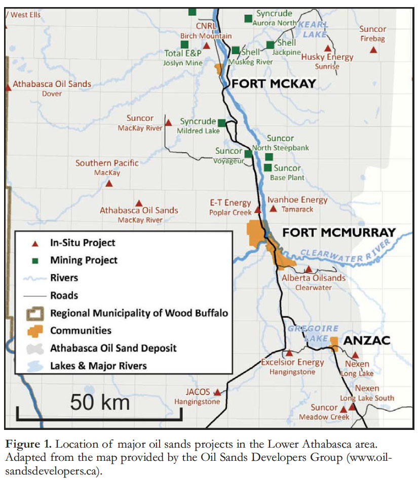 Display large image of Figure 1
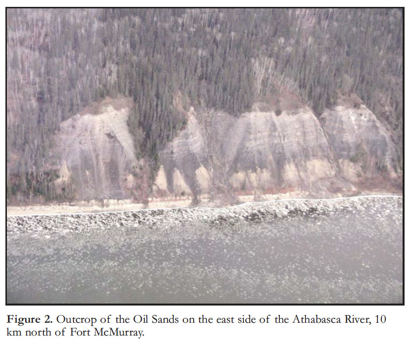
2 Cliffs along the Athabasca River and its tributaries show the sands resting unconformably on Devonian carbonates (Fig. 2). The bitumen is hosted in the McMurray Formation of Barremian–Aptian (Lower Cretaceous) age (Fig. 3). During warm weather the bitumen bleeds from the outcrop face and may flow slowly into the river (Fig. 4). This highly visible presence of bitumen-saturated sands was well known to the First Nations and early explorers in the area.
3 According to Alberta Energy (http://www.energy.alberta.ca/about_u s/1133.asp), “The first known reference to the Athabasca oil sands was made by Captain Swan, a Cree chief acting as a middleman between the native hunters of the west and the fur factories of Hudson Bay. Swan told Governor James Knight in council at York Fort in 1715 about a river feeding the Churchill River where he found ‘Gum or pitch’. In 1719 Swan returned to York Fort, where Henry Kelsey had replaced Knight as governor. He gave Kelsey a sample of ‘that Gum or pitch that flows out of the Banks of that River. [In 1788 Alexander Mackenzie wrote] of bituminous seeps among Alberta’s Athabasca [River], into which a six-metre pole could be inserted ‘without the least resistance’.”
4 “The first European to see the Athabasca oil sands was fur trader Peter Pond, who was lured to the area in 1778 by tales of the rich fur harvests there.” (Syn-crude, Oil Sands History, http://www.syncrude.ca/users/folder.a sp?FolderID=5657).
5 An island in the Athabasca River 28 km downstream from Fort McMurray became referred to as Tar Island, a name that was first recorded by the Geological Survey of Canada in 1892. The island later became the site of the first tailings pond when development of the oil sands commenced in the 1960s, as discussed below. The island no longer exists because Tailings Pond #1 was built over it.
6 The outcrop conditions described here make it obvious that the surface water system would be affected by natural hydrocarbon pollution. As Environment Canada (2010, p. 14) noted:
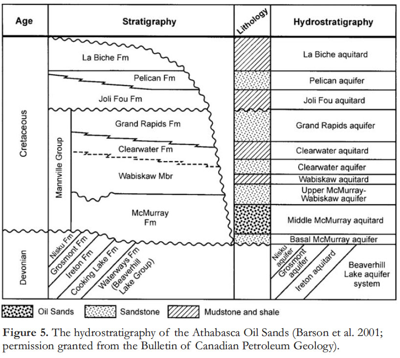
7 The purpose of this paper is to review the hydrostratigraphy (Fig. 5) and environmental hydrogeology of the Lower Athabasca area, and to discuss the regional background work that has been carried out on the groundwater system, and the possible effects on this system of oil sands mining operations. Industrial disturbance includes the surface mining, the in situ production operations, surface access roads, and the long-term environmental effect of the tailings ponds, including the planned evolution of these ponds into what are called ‘end-pit lakes.’ While a considerable amount of corporate groundwater research has been carried out to meet the requirements of Environmental Impact Assessments (EIA) for individual projects, very little of this research is available in a form accessible to or understandable by the general reader. Almost none has been published in peer-reviewed journals, with the exception of some studies of tailings ponds referred to below.
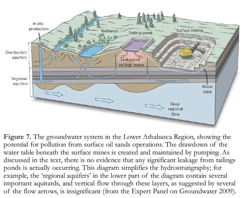
8 Studies by Kelly et al. (2009, 2010) and Kurek et al. (2013) (see summary by Schindler, this issue) make it clear that the most significant source of industrial pollution in the Athabasca system consists of airborne pollutants from the processing and upgrader facilities, which may settle out into lakes and the rivers up to about 100km from source (see Percy 2013). Some of this pollutant could be carried into the shallow groundwater system from uplands that act as local recharge areas. As yet, this possibility has not been investigated. Likewise, direct downward leakage from tailings ponds could be occurring (Figs. 6, 7). Some work, discussed below, suggests that the tailings ponds are not causing this kind of environmental problem, but leakage could be a very slow process, and enough time may not yet have elapsed for definitive conclusions to be drawn on this point.
 Display large image of Figure 2
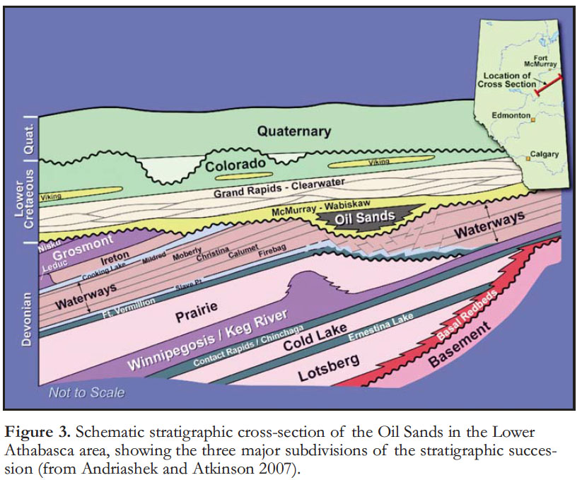 Display large image of Figure 3
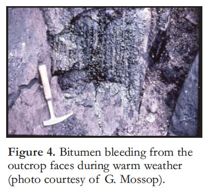 Display large image of Figure 4
9 An additional concern is the practice of disposing of polluted waters from the in situ processing operations by injection into the deep saline aquifers. Although this removes the water from current surface environmental concerns, nothing is known about the long-term implications of this practice. Will polluted waters, containing polyaromatic compounds (PACs), trace metals and other industrial products emerge from discharge areas into the surface water system decades from now? Many PACs are known or suspected carcinogens; therefore the issue of surface water and groundwater pollution is of considerable concern to the mainly First Nations residents of the area, including those at Fort McMurray, Fort MacKay and Fort Chipewyan.
10 The Royal Society of Canada Expert Panel (2010, p. 111) reported that “The production of 1 m3 of synthetic crude oil (upgraded bitumen) requires about 2.5 m3 of water by surface mining and about 0.5 m3 of water by in situ recovery.” Continuing improvements in industry practices regarding water use are being reported every year. For example, in its 2012 Sustainability report Suncor Energy (2012) claimed that “About 75 per cent of the water used at our oil sands mining operations is recycled tailings water. More than 90 per cent of the water at our in-situ facilities is recycled, and we use mostly saline groundwater or recycled wastewater from our oil sands mining operations as makeup sources.” Water withdrawal from the Athabasca River by Suncor has declined 50% since 2004, and water use, in general, has decreased significantly as a result of incremental improvements in the processing and upgrading procedures. Lunn (2012) stated that after start-up, about 80% of the water used in surface mining operations is recycled tailings water. He also recorded that total water use by the oil and gas industry in Alberta represents 8.4% of the province’s fresh water supply.
 Display large image of Figure 5
11 The Canadian Association of Petroleum Producers (CAPP) (2013) reports that “Current oil sands fresh water use is approximately 170 x 106 m3/yr. In 2010, their data indicate total water withdrawals from the Athabasca River of 3.4 m3 /sec, a total of 130 x 106 m3 during the year, representing 0.6% of average total river flow and less than 3% of low winter flow.” CAPP (2013) reported that in 2011, 80% of the water withdrawn for oil sands mining was from the Athabasca River, totaling 112 x 106 m3, representing 0.5% of the average annual flow and 3% of the lowest winter low flow. Lunn (2012), using data provided by CAPP, estimated that water withdrawals from the Athabasca River system would rise to 9 m3 /s (283.8 x 10⁶ m3 /yr) by 2030, representing 1–1.4% of the average annual flow of the river at Fort McMurray. MacMillan and Smith (2009) estimated that in situ operations at the 22 existing and planned steam-assisted gravity drainage (SAGD) operations will require groundwater at the rate of 150 000 m3 /day (54.7 x 10 6 m 3 /yr). The use of saline water, while reducing the need for surface water or fresh groundwater, introduces its own problems, including the need for additional well drilling, dedicated pipelines, processing costs, and the disposal of waste (sludge, salt) (Griffiths et al. 2006, p. 18). Federal and provincial regulations are in place to monitor and, if necessary, limit water withdrawal during low-flow winter months.
 Display large image of Figure 6
12 Much of the controversy surrounding the environmental management of the oil sands stems from the perceived inadequacy of existing government-management monitoring programs, notably RAMP, the Regional Aquatic Monitoring Program. The RAMP program focuses on surface waters affected by surface mining operations, and its results and conclusions were thrown into doubt by the detailed analyses of Kelly et al. (2009, 2010). This paper is not the place to review the criticisms of the RAMP program, which were documented by Ayles et al. (2004) and Hatfield Consultants (written communication 2010), and have been discussed by the Royal Society of Canada Expert Panel (2010), the Federal Oil Sands Advisory Panel (Environment Canada 2010) and the Alberta Environmental Monitoring Panel (AEMP 2011).
 Display large image of Figure 7
13 This summary paper draws extensively on the above mentioned reports, and other studies prepared by or for the Cumulative Environmental Management Association and the Oil Sands Research and Information Network. Few peer-reviewed studies of groundwater issues have been carried out (except for some detailed studies of tailings ponds), reflecting a lack of independent research. As noted in the concluding section of this paper, some major Alberta government and industry initiatives have now begun to collect the kind of data that the various panel studies (noted above) have indicated is required in order to ensure an appropriate level of management of the groundwater system in the Lower Athabasca region.
Hydrostratigraphic Setting of the Athabasca Oil Sands
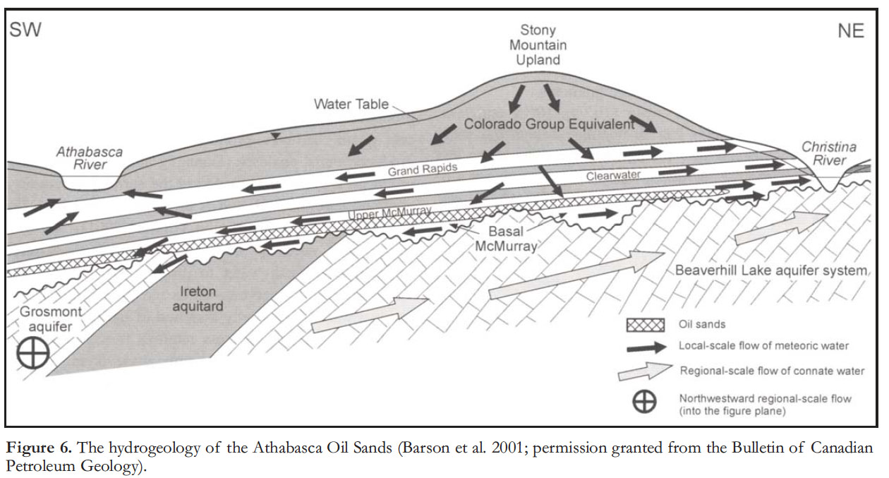
14 Regional hydrogeological studies in the Lower Athabasca region have been carried out by Barson et al. (2001) and by Worley Parsons Canada Ltd. (2010) for Alberta Environment. Groundwater studies are also an essential component of the provincial Environmental Impact Assessment process, but very little of the data generated by these studies is analysed and available in publicly accessible form. These studies have demonstrated that the groundwater system in the Cretaceous units range from shallow and local in origin with water recycling over a 102-year range, to intermediate-depth cycles which, in some cases, show evidence of incomplete adjustment to the influx of glacial meltwater and to changes in land elevations since the Pleistocene (Grasby and Chen 2005). Recharge is from topographically high areas, such as the Stony Mountain Uplands south of Fort McMurray, and discharge into the river systems, where the water contributes to river base flow (Figs. 6, 7). For example, Timoney and Lee (2009, p. 67) stated that most of the waters of the Muskeg River (a major tributary that enters the Athabasca River near Fort McKay) derive from the shallow groundwater, “much of which may flow through shallow organic soils at the peat/mineral interface.” Worley Parsons Canada Ltd. (2010) estimated that the total groundwater discharge to the Athabasca system within the Lower Athabasca region is in the range of 1350 x 10 6 m3 /yr, constituting between 40 and 100% of total low-flow discharge.
15 The hydrogeology of the oil sands units includes several interbedded aquifers and aquitards of Cretaceous age, resting unconformably on Devonian carbonates (Fig. 5). The Middle McMurray Formation, the unit containing the bitumen, functions as an aquitard. Although much of it consists of sands and silts, the pore spaces are saturated at up to 85% with bitumen, which is immobile at natural temperatures. The remaining pore space contains water which is essentially irreducible. The Lower McMurray Formation comprises porous sands and gravels. It is discontinuous in distribution, filling erosional channels and karst sinkholes in the underlying Devonian carbonates. “The Grand Rapids and Clearwater aquifers are characterized by formation waters with low total dissolved solids (TDS) and sodium-bicarbonate (NaHCO3)- rich chemistry, typical of meteoric recharge waters. The upper McMurray-Wabiskaw and basal McMurray aquifers have higher total dissolved solids than the overlying aquifers, and sodium-chloride-bicarbonate (Na-Cl-HCO3) water chemistry, which indicates meteoric-recharge waters with a longer residence time and flow path. The water chemistry and salinity profile is consistent with a vertically downward recharging flow system” (Barson et al. 2001, p. 382). Other studies have provided more quantitative data for aquifer salinities. Worley Parsons Canada Ltd. (2010) indicated that in the area south of Fort McMurray Total Dissolved Solids (TDS) in the Grand Rapids aquifer ranges from 417 to 14 392 mg/l. In the discontinuous McMurray basal aquifer TDS values range from 2194–69 700 mg/l, lower values occurring in the shallower portions of the aquifer towards the north. The Upper McMurray, Clearwater and Grand Rapids aquifers all contains isolated gas pockets.
 Display large image of Figure 8
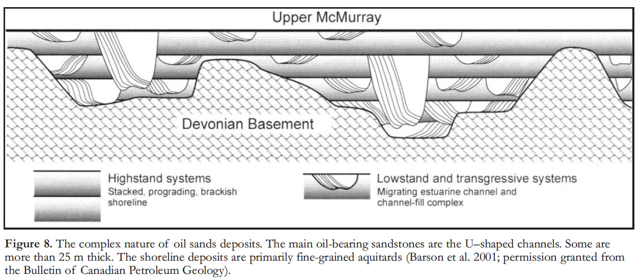
16 The areas where the McMurray Formation is at deeper levels and is only accessible by in situ extraction, the groundwater connection to shallow systems is limited by the presence of interbedded aquitard units, and here overturn is much slower, on time scales of thousands of years, except where the stratigraphy is intersected by bedrock channels, as noted below.
17 A deeper saline flow system originates with recharge in the Rocky Mountains of Alberta and Montana, and consists of very slow subsurface flow through the Paleozoic section, requiring many thousands of years for a water molecule to travel the entire distance to the discharge zone in northeastern Alberta. The salinity (TDS commonly >10 000 mg/l) reflects passage of this water system through several thick evaporite units within the Paleozoic section. In some places this deeper system is intersected by the Athabasca River and its tributaries, and tests show that a modest contribution of saline waters to the surface water takes place at these discharge locations (Jasechko et al. 2012). This contribution fluctuates with the seasons, ranging from 1.5% in the winter low-flow months to as little as 0.1% during the summer, when the ground-water discharge is diluted by the higher summer discharge.
18 The top surface of the Cretaceous section is a regional unconformity, the configuration of which was created by glacial scour during the late Cenozoic. The unconformity is cut by a suite of deeply incised drainage channels, termed buried bedrock valleys by Andriashek and Atkinson (2007). The channels contain up to 90 m of water-saturated fluvioglacial sands and gravels that function as local, isolated aquifers. The channels are now covered by fine-grained glacial sediments and peat and have no surface expression. However, because they incise deeply into the Cretaceous bedrock the channels are of considerable significance to the hydrogeological integrity of the McMurray Formation, and must be taken into consideration in the operation of in situ projects, as discussed below. In places the channels have cut through the aquitard layers within the Cretaceous section, thereby providing fluid connection between several of the aquifers in that section.
19 The hydraulic head of the Cretaceous aquifers is typically higher than that of the basal, Paleozoic, saline water system (King and Yetter 2011). Normally this prevents the saline waters of that system mixing with the surface fresh water system. However, as noted below, an accidental breaching of the saline waters at the base of a completed surface mine led to the sudden appearance of a saline spring in the floor of the mine.
20 As the Ayles et al. (2004, p. 9) review of the RAMP program indicated: “Local groundwater resources are predicted to be significantly affected by oil sands developments.” The underlying Devonian limestones contain a deep, regional flow system originating from recharge areas in the Rocky Mountains as far south as Montana. This is a highly saline system, with limited mixing at the unconformable contact with the overlying Cretaceous. Where the groundwater system remains undisturbed, it is likely to consist of a complex of small circulation cells because of the intricate interbedding of aquifers and aquitards, reflecting the original depositional fabric of the deposits (Figs. 6, 8). A program of detailed water sampling and analysis down through an undisturbed control volume would provide an essential background for consideration of the degree of industrial disturbance.
21 Operators are required to answers these kinds of questions as part of the Environmental Impact Assessments (EIA) process:
- How are surface mining operations affecting local groundwater systems?
- How do SAGD (steam-assisted gravity drainage) operations affect local groundwater systems?
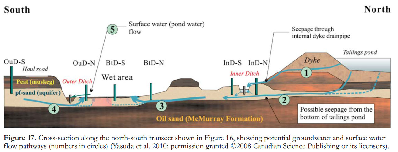
- What levels of pollution can be detected in groundwater adjacent to tailings ponds, salt landfills, or surface installations where leakage and dumping may have taken place?
- How safe is the practice of disposal of process waters into the deep saline groundwater system at the in situ projects, given that these waters may eventually discharge at the surface?
22 With reference to the impact assessment process for each new mine project the Royal Society of Canada Expert Panel (2010, p. 116) stated that “Hydrogeological studies are conducted on a case-by-case basis and the cumulative impacts of all surface mining on groundwater levels and flow rates are not quantified.“ Indeed, cumulative effects management is one of the most significant challenges facing the industry in the long run, and to date there has been no systematic publication or peer-reviewed evaluation of the relevant hydrogeological studies.
23 Ayles et al. (2004, p. 9) had “recommended that the RAMP hydrology monitoring program consider: monitoring local and regional groundwater by data acquisition from oil sands developers; and groundwater monitoring station placement in areas considered environmentally sensitive that are outside of oil sands developers’ existing and proposed groundwater monitoring zones.” Further (p. 22) they suggested: “Include local and regional groundwater monitoring by data acquisition from oil sands developers; place groundwater monitoring stations in areas considered environmentally sensitive and outside of oil sands developers’ existing and proposed monitoring areas.” Such studies are being carried out as part of the EIA process, but are not being independely evaluated for accuracy or published. New government initiatives in this area are referred to later.
Natural Versus Industrial Pollution: Studies of Pond and Lake Sediments
24 Natural bitumen concentrations have been identified in river waters and sediments of the Peace–Athabasca Delta, more than 100 km downstream from the oil sands mineable area (Timoney and Lee 2009; Hall et al. 2012, p. 2). This confirms the significance of the natural fluvial erosion of the McMurray Formation by the Athabasca River and its tributaries. It is a different question, however, whether pollution of industrial origin, including the carcinogenic PACs and toxic metals, are present in sediments or groundwater this far from the industrial sites.
25 The studies reported by Percy (this issue) and Kurek et al. (2013) indicate widespread airborne dispersion of trace amounts of industrial pollutants. Where these pollutants settle in the surface waters or in upland recharge areas there therefore exists the potential for direction contribution of pollutants to the surface groundwaters. As demonstrated by Kelly et al. (2009, 2010) and Kurek et al. (2013), airborne pollutants may show high concentrations in spring snowpack, in water, and in river and lake sediment samples within some 100 km of the industrial sources.
26 Beyond the limit of airborne transport, the movement of industrial pollutants would be from airborne particulates and droplets landing on the surface waters that are then carried downstream (Schindler 2013) or by landing on the forest floor and being absorbed into the groundwater system. Landscape disturbance of the oil sands (surface mines, roads) could add a significant source of wind-borne ‘natural’ bitumen pollution to adjacent surface waters (Kelly et al. 2009, p. 22350). It is highly unlikely that industrial pollutants, which have been generated in significant volumes only since the late 1960s, would have yet travelled very far into the groundwater system, except where the surface glacial cover sits on the buried channels, where rapid surface recharge is possible (Andriashek and Atkinson 2007, p. 74).
27 The detailed sampling and analysis of Peace–Athabasca delta sediments by Hall et al. (2012) confirmed the presence of a range of PACs, similar in composition and quantity to those found in river sediments from the mineable area upstream. All of these compounds are regarded as most likely having originated by natural decomposition of the bitumen.
28 The lake-floor sediments in three lakes in the delta were also sampled by Hall et al. (2012). The sedimentary records of these lakes, dated using 210Pb techniques, demonstrate varying histories of flooding or isolation from the river system, reflecting the avulsion history of the river and changes in water levels induced, in part by upstream development, such as the construction of the Peace River Dam in British Columbia. One of the lakes within the delta, designated lake PAD 31, has had a history of being flood prone pre-1940 and post-1982, Sediments from these intervals in the deposits contain PAC distributions similar to those from the delta, whereas sediments accumulated during periods of isolation contain only those PACs generated by local fire and natural decomposition of the vegetation. No attempt appears to have been made by Hall et al. (2012) to isolate the more volatile and five-ring PACs which Kelly et al. (2009) detected in samples from near the industrial facilities, and which are interpreted as the product of industrial combustion (termed ‘petro-genetic’) rather than having been generated by forest fires.
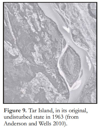 Display large image of Figure 9
29 Kurek et al. (2013) analyzed lake sediment records from 6 sites north of Fort McMurray. Five of those were within ~35 km of the Suncor Voyager plant, where oil sands operations began in 1967 (Figs. 9, 10). From each of their dated cores, they measured: 1) Polyaromatic hydrocarbons (PAHs), 2) trends in primary production (algal productivity), and 3) abundances of zooplankton (some species are commonly used in toxicology; are sensitive to PAHs and metals, etc.). Overall, their data show major shifts in some of the above measures consistent with greater oil sands development post late 1960s–early 1970s and consequent increased airborne transportation of pollutants. One of their sites has exceeded sediment quality guidelines for PAHs since the mid-1980s. Using mass spectrometry, Kurek et al. (2013) were able to distinguish ‘petrogenetic’ polyaromatic hydrocarbons (PAHs) (those generated within the upgraders) from those generated from bitumen by forest fires. Except within samples a few kilometres from the upgraders, concentrations of these substances were typically an order of magnitude lower than comparable samples taken near coal-fired power plants. An interesting feature of the zooplankton data is that climate warming may be trumping the expected effects (negative) of increased contaminants on key indicator species. The types of lakes Kurek et al. (2013) focused on should better reflect atmospheric deposition patterns from the upgraders than those of Hall et al. (2012) which are up to 200 km north of the Suncor Voyageur plant and are subject to seasonal flooding. Hall et al. (2012) identified these flood events as an important vector of PAHs to the Peace–Athabasca Delta.
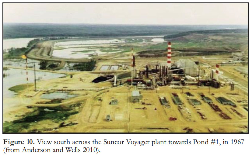 Display large image of Figure 10
The Open-pit Mines
30 Surface mining is practical and economic where the base of the oil sands lies at 75 m or less below the surface. This is the case for only 5% of the total area underlain by the Athabasca deposit, but to this disturbed area must be added the area required for tailings ponds (most of which are in fact former mine sites from which the oil sands have been removed), roads and other access points, and the processing facilities.
31 The open-pit mines must be as free as possible of standing water in order for efficient mining and removal of the sands. The surface may be removed to depths of up to 75 m. Groundwater is therefore continuously pumped from the subsurface, significantly lowering the local water table (Fig. 7), locally by as much as 40 m (Royal Society of Canada Expert Panel 2010, p. 112; Fennell et al. 2011). Much, if not most of this water is used in processing operations, but some, unless contaminated by contact with disturbed bitumen-bearing sediment, is discharged into the surface water system. This depressurization may affect the water table for several kilometres around a particular mine, requiring cooperation between adjacent leaseholders where shallow groundwater is being used as a resource (King and Yetter 2011). Some groundwater pollution is to be expected from these operations resulting from the disturbance of bitumen-laden sedimentary layers. However, it is unlikely in the short term that this source of pollution would add much to the natural background that characterizes the surface water cells identified by Barson et al. (2001). Surface runoff may carry pollutants released by mine disturbance into nearby surface drainage, and pollution certainly enters the rivers and stream system this way. More significant is the subsequent use of the open-pit mines as tailings ponds, and the potential effects on the surface and groundwater system of the presence in these ponds of enormous volumes of process-affected water (PAW).
32 In December 2010 shovel operations at the Shell Muskeg River operation were in progress to prepare a mined-out surface pit for use as a tailings pond. A spring developed at the bottom of the pit, consisting of saline water and containing small quantities of dissolved hydrogen sulphide, indicating that the pit had penetrated the deep saline groundwater system that pervades the Devonian bedrock (Fig. 6). This problem is now contained.
The Tailings Ponds
33 The first tailings pond, Pond #1, was established at a bend in the Athabasca River in 1963 (Fig. 9). Tar Island was used as the basis for a dyke, constructed primarily from the processed sand from which the bitumen had been removed, and built to create an enclosed area on the west bank of the river into which tailings waters from the Suncor Voyager plant would be discharged (Fig. 10). Tailings consist of the large volumes of initially fresh water used in the processing operations, loaded with a range of polyaromatic compounds (PACs), naphthenic acids, trace metals and other substances, mixed with large volumes of the fine clay separated out from the sand, plus residual traces of bitumen that has not been removed from the sand. The initial plan was that the pollutants and fine clay would settle to the bottom of the pond, leaving clear water that could be treated and discharged into the surface water system. Once filled with these dry tailings, the surface would be covered with the soil that had initially been stripped to expose the oil sands and stored elsewhere. The soil would be seeded, and the boreal forest eventually re-established.
34 Currently there are 20 tailings ponds, covering approximately 170 km2 of the Oil Sands Mineable Area (Jaremko 2012). The early hopes that the fine clays, called Mature Fine Tailings (MFT) would settle, were not fulfilled, with the clay remaining in suspension for periods predicted to last for decades. Until recently, this had constituted a growing environmental problem, because it meant that many new, large ponds would be required as new surface operations got underway. The ponds already constitute some of the largest man-made disruptions of the Earth’s surface, easily seen from space (visible using Google Earth), a major hazard for birds, and a continuing concern regarding the potential for leakage into the surface water system (Fig. 7).
 Display large image of Figure 11
35 In order to address this significant problem, the major industry players in the area came together to form the Oil Sands Tailings Consortium (OSTC) in 2010. Various technologies were tried in attempts to make the fine clays settle, and eventually some of these have proved successful (Jaremko 2012). Suncor uses a system based on the polymer polyacrylamide, a common water-treatment chemical, which causes clay to flocculate. The discharged tailings are mixed with this polymer, and spread out over sloping banks at the margins of a pond. Drying takes weeks, instead of years (or even, as formerly predicted, decades), and Suncor has stated that it will not now need to create any additional ponds, as had been planned (Suncor Energy 2012). Complete restoration of a pond may now take only a few years, rather than the 40 years that had been predicted. Other technologies include the use of centrifuges, and mixing of the MFT with gypsum (Syncrude 2013). In any case, this appears to be a technical problem for which practical solutions have now been found for use on a large scale.
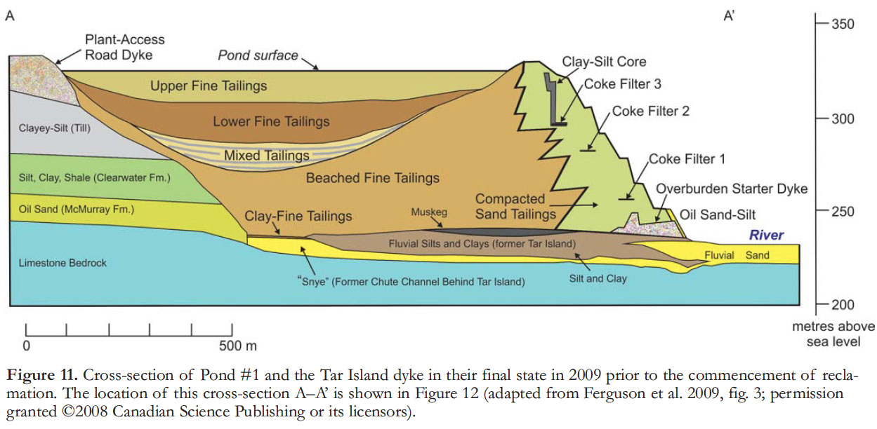
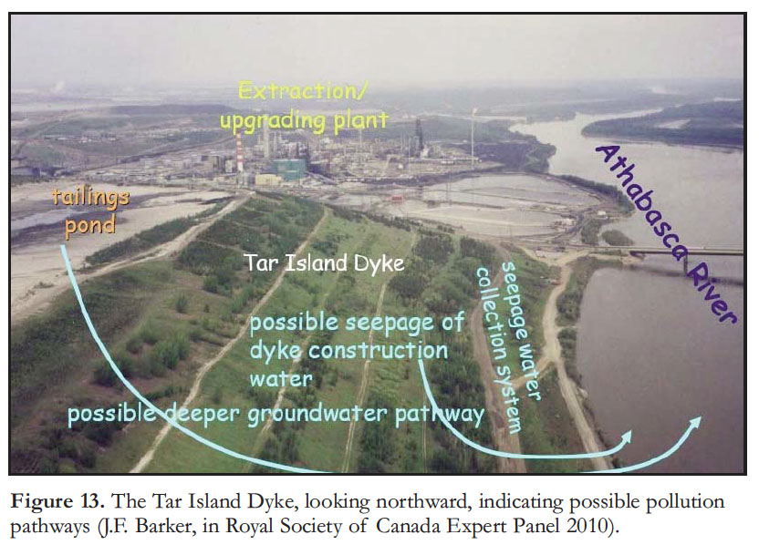
36 What about the problem of leakage from the ponds into the surface waters or the groundwater? Timoney and Lee (2009, p. 72) summarized their own and other data relating to seepage from several of the tailings ponds into the surface waters. Tracer tests at a number of seepage sites along the Athabasca River and its tributaries suggest that leakage of PAW into the river system is at low to negligible levels (Gibson et al. 2011). The most critical area of concern in this regard is the margin of Pond #1 which, since 1963, has been gradually built to a height of nearly 100 m above the level of the Athabasca River (Figs. 11, 12). This first pond, Pond #1, is now at a relatively advanced state of restoration, as discussed below. The scale of the hydraulic head represented by the Tar Island Dyke is illustrated in Figure 13.
37 A cross-section of Pond #1 shows the layer of sand forming the base of the pond and the retaining wall (Fig. 11). “A clay core was installed near the crest to divert seepage water at this elevation towards the uppermost filter drain. A seepage water collection system was designed to collect and return seepage water into the pond” (Ferguson et al. 2009, p. 1448). Water sampled from the monitoring wells installed in the dyke indicated levels of naphthenic acids and toxicity consistent with seepage from the tailings waters. Water from wells installed in the river sediments at the toe of the dyke yielded some modest evidence of seepage. “Groundwater sampled from the fluvial sand zone beneath the Tar Island Dyke suggested a mixture of fresh and process-affected water at these locations” (Ferguson et al. 2009, p. 1453). However, the silt and clay that originally comprised Tar Island served as a low-permeable barrier, impeding outflow of the tailings process waters from the base of the pond.
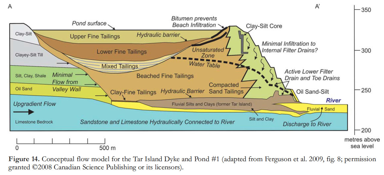
38 Using the hydraulic head measurements and the measured hydrogeological properties of the various components of the dyke and the pond fill, Ferguson et al. (2009) constructed a flow model for the pond (Fig. 14). This suggested that the dyke and the foundation layers of the pond would slowly drain, reaching a steady-state condition of partial saturation by 2100, whereas the tailings of the pond fill would remain as a perched, saturated body for the foreseeable future—in other words, further substantial seepage did not seem likely. Drainage of the dyke, in reducing water saturation, also increased the mechanical strength of this construction, an important consideration given the impoundment of significant volumes of toxic tailings tens of metres above the Athabasca River.
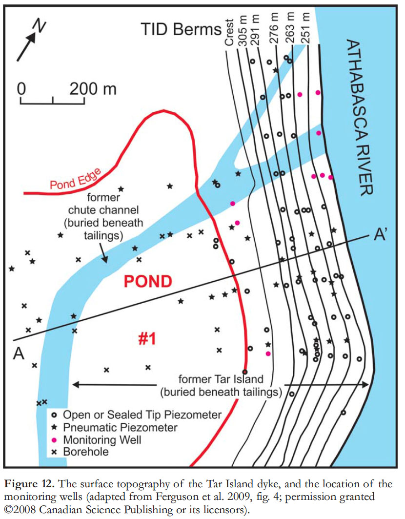 Display large image of Figure 12
39 Ferguson et al. (2009, p. 1458) concluded: “The properties of oil sand tailings, and the design of the impoundment, have produced a condition in which the environmental impacts to surface water and groundwater quality appear to be low and progressively decreasing.” This possible source of pollution for the surface water system does not seem, then, to be significant. However, the position of Pond #1, literally looming over the river above a 100-m dyke (Fig. 15) is extraordinary. Current environmental impact procedures would in no way permit the siting of a tailings pond in such a sensitive position.
40 Pond #1 has now been dried out and seeded. Figure 15 provides an aerial view of the pond as it was in November 2010, showing the grass cover. Plans call for the re-establishment of boreal forest vegetation and attempts to re-create small wetlands, an undertaking for which the ultimate success cannot be predicted at the present time (Rooney et al. 2012).
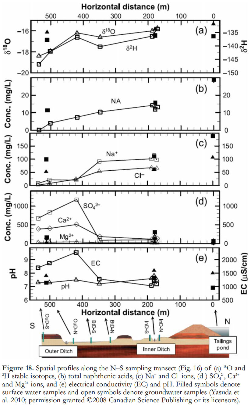
41 Another study of tailings-pond hydrogeology was reported by Yasuda et al. (2010). This was an examination of the pond at the Muskeg River Mine, across the Athabasca River from Fort McKay. This pond is enclosed by an 11-km long ring-dyke constructed of permeable tailings sand and seepage collection ditches, which were designed to collect water from drains in the dyke and to intercept seepage water (Figs. 16, 17). “To evaluate the performance of the seepage collection ditch system to contain PAW [process affected water] in the study area, instrumentation was installed to collect data to quantify the flow system and groundwater chemistry. Specifically, hydraulic head and flow measurements were used to provide basic data for the interpretation of the hydraulic system of the study area, and groundwater and surface water samples were collected to develop an understanding of the impact of PAW downgradient of the tailings pond” (Yasuda et al. 2010, p.1307). Water samples were collected from the piezometers and drive points over the course of four sample periods spanning 20 months in 2004–2006. Water samples were also collected from several locations within the surface water system shown in Figure 16. Water samples were analysed for major inorganic ions and total naphthenic acids (NAs). Water samples from selected piezometers were analyzed for stable isotopes (18O and 2H), and for both total NA and detailed NA characterization. The results, organized to show changes downflow from the dyke, are shown in Figure 18. “Overall, the chemical evolution trend along the transect from the north (tailings pond) to the south (Outer Ditch) is characterized by an increase in the concentrations of SO2- and Ca2+, and a decrease in pH and in the concentrations of Na+ and Cl-ions” (Yasuda et al. 2010, p. 1311).
42 The study by Yasuda et al. (2010) included a particular focus on naphthenic acids. These are a group of highly soluble organic acids which, in elevated concentrations, can have a negative effect on plant and animal life. The distribution of these components in the PAW is shown in Figure 18b. The data show a decrease in concentration away from the dyke, and no change in distribution was observed over the 20 month sample period. The downstream decrease, and the stability in concentrations, is attributed to in-place biodegradation of these pollutants.
43 The stable isotope studies are useful in tracking pollution flow because the PAW, by virtue of the heating it undergoes as part of the processing, has a distinctive stable-isotope signature. The data show that water samples obtained from near the foot of the dyke are enriched in 18O and 2H, reflecting evaporation and selective concentration of these heavier isotopes from the surface of the pond from which these waters were derived. Samples taken from further away had isotope ratios similar to that of local meteoric water.
 Display large image of Figure 13
44 Modeling studies conducted using the hydrological characteristics of the dyke and pond materials and the hydraulic head and water composition data obtained in Yasuda et al. (2010) suggested that for PAW to migrate from the southern portion of the tailings pond along pathway 1 or pathway 2 to the Inner Ditch would take about 650 days.
45 In their summary of findings Yasuda et al. (2010, p. 1313–1314) stated:
46 Given the nature of the dyke construction and the imposed hydraulic head it is considered that transport of PAW offsite and into the groundwater system is negligible. The drainage ditches are effectively capturing the PAW and transporting it to the seepage ponds, where it can be collected. The distinctive chemistry of the PAW provides multiple tools for tracking PAW in future tailings pond studies.
47 Developments in analytical isotope geochemistry permitted Savard et al. (2012) to perform a more thorough test of tailings pond leakage, focusing on naphthenic acids and the metals lead and zinc. Working on a tailings pond dyke, their samples and hydrogeological modeling indicated that enough time would have elapsed since the establishment of the pond for industrial pollutants to reach the Athabasca River, but their results showed that this was not happening. They suspected that only very small quantities of these pollutants were escaping through the dyke, that the metals were being adsorbed into the soil and the acids were decomposing before they reached the river.
 Display large image of Figure 14
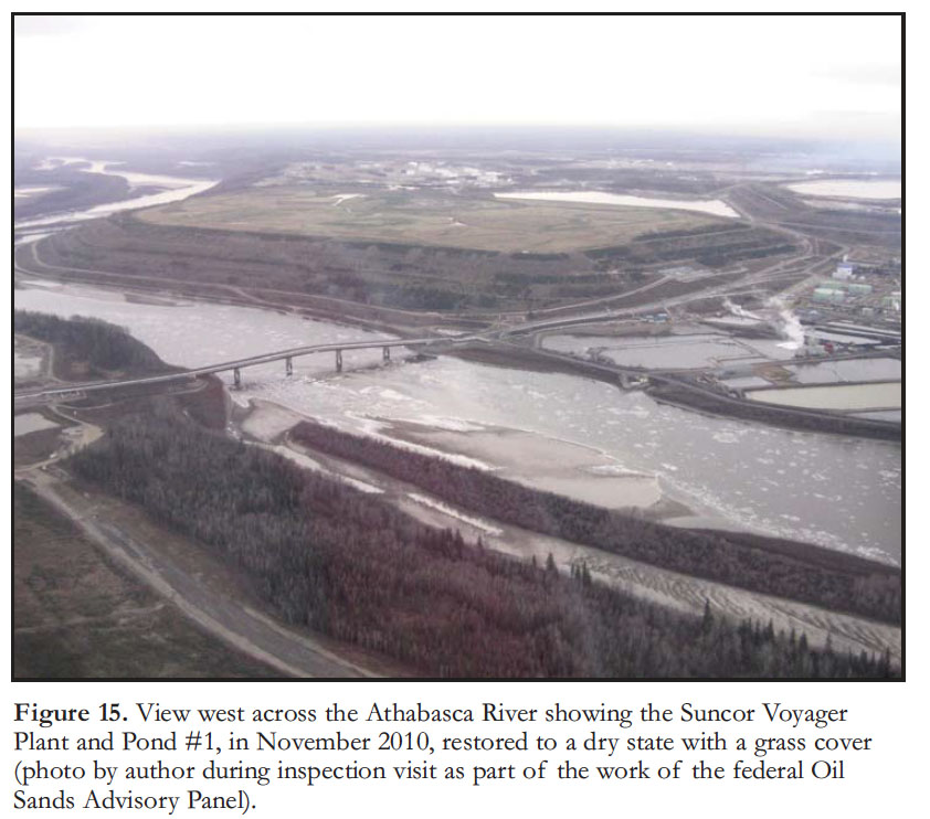 Display large image of Figure 15
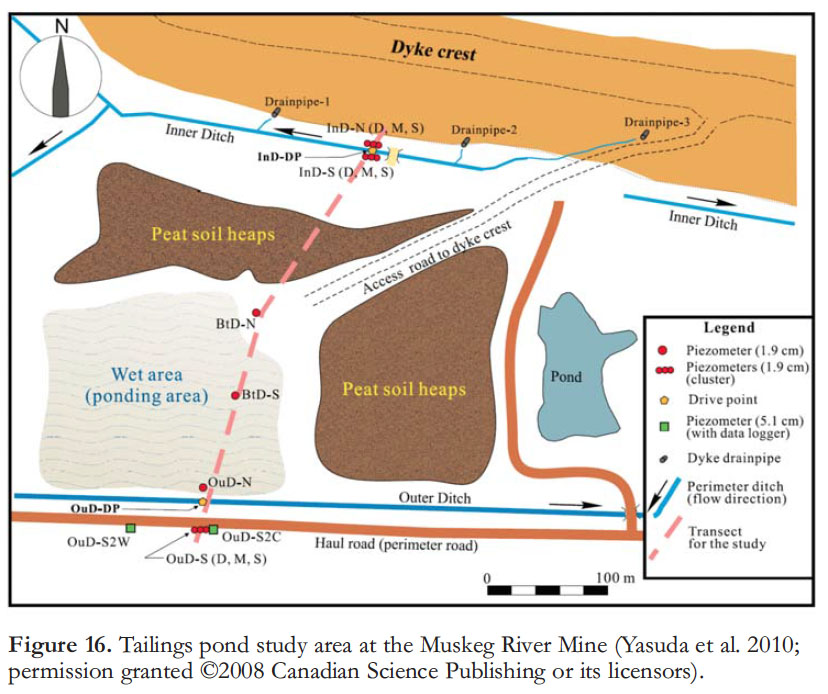 Display large image of Figure 16
Hydrogeology of In Situ Projects
48 The basics of the steam-assisted gravity drainage (SAGD) process are well-known and need not be repeated here (O’Rourke et al. 1994; Barson et al. 2001). The principal requirement for the SAGD process to work effectively is that the reservoir volume would operate with the porosity-permeability characteristics of an aquifer if the bitumen saturation was not present. This allows the heated oil to flow through it as it would in a conventional reservoir. The bitumen-saturated interval must be bounded above by a coherent aquitard, much as in a conventional oil and gas trap. Under steam pressures of >1500 kPa and temperatures of more than 230°C the bitumen viscosity is significantly reduced so that it flows downward into the collecting pipes. As the bitumen and condensed water flow downward the steam chamber expands outwards in all directions. If there is no impermeable layer in the reservoir unit the steam chamber will continue to expand. However, if it expands upward to the top of the bitumen layer it may encounter the water-saturated upper McMurray aquifer (which is not present everywhere), at which point the high steam pressures and temperatures will rapidly drop, as the fluids equilibrate with the low temperatures and pressures of the natural ground-water system. At temperatures of less than 60°C the SAGD process ceases, although its efficiency, and therefore economic returns, drop well before this point is reached. It is therefore essential that the project managers be aware of the detailed composition and architecture of the bitumen-bearing unit. The expansion of the steam chamber is designed to leave a layer of bitumen-bearing sand both at the top and bottom of the producing volume in order that the integrity of the steam chamber is maintained.
49 Ko and Donahue (2011) listed some possible concerns associated with SAGD development. These are summarized below, with comments added in brackets, based in part on Fennell et al. (2011):
- Surface land disturbances and unsealed wells that increase the potential for groundwater contamination [all wells are required to have casings that are sealed to thehost rock with thermal cement, but failures are not uncommon];
- Uncertainties regarding groundwater supplies that complicate the ability of in situ oil sands projects to meet their approval obligations to rely on groundwater for steam production [the EIA process requires detailed modeling of the hydrogeology for each project to ensure that there are adequate groundwater resources, but cumulative effects remain to be evaluated];
- Drawdown effects on the water table from water used to generate steam [this is in fact regulated by Alberta Environment];
- Buried groundwater channels that could permit vertical and horizontal movement of contaminants from in situ oil sands operations [operators must of necessity avoid these channels because they negate the pressure regime necessary for SAGD to work; therefore this is a worst-case issue. Good geological mapping needs to be an integral part of project design];
- Shallow aquifers that are particularly susceptible to harm and play an important role in recharging regional lakes, rivers, and streams [in situ operations are below the level of these aquifers, therefore they should not be affected].
50 Currently the water used in SAGD operations in the Lower Athabasca region consists of surface water (22%), fresh groundwater (34%), and deep saline groundwater (44%) (Ko and Donahue 2011). Operators are limited to withdrawal of 50% of the available hydraulic head of surface fresh water at a distance of 150 m from the source well.
 Display large image of Figure 17
51 The use and disposal of saline groundwater is tracked by the Alberta Petroleum Registry and injection is governed by Energy Resources Conservation Board (ERCB) rules, but there are some concerns that background data on deep flow systems is inadequate to effectively monitor any movement of pollutants, or to project long-term effects on the regional groundwater system.
52 Until recently, provincial operating rules did not require measurement or management of saline waters (those that contain more than 4000 mg/l of dissolved solids). Likewise, detailed knowledge of the fresh groundwater system is lacking, which means that appropriate decisions about permitting for the withdrawal of fresh groundwater are not based on a complete understanding of the regional hydrogeology. While groundwater use is required to be ‘sustainable’, the basis for assessing what sustainability actually means in practice is only now being developed. For example, how much groundwater flow is required to maintain water tables sufficient to support nearby wetlands? The Royal Society of Canada Expert Panel (2010, p. 113) reported studies showing that as much as 14% of the annual inflow for lakes in the Fort McMurray area is derived from groundwater discharge. Alberta Environment and Sustainable Resource Development began to develop a Groundwater Management Framework in 2008, and this has now been supplemented by the Alberta government’s Lower Athabasca Region Groundwater Management Framework (implemented in August 2012).
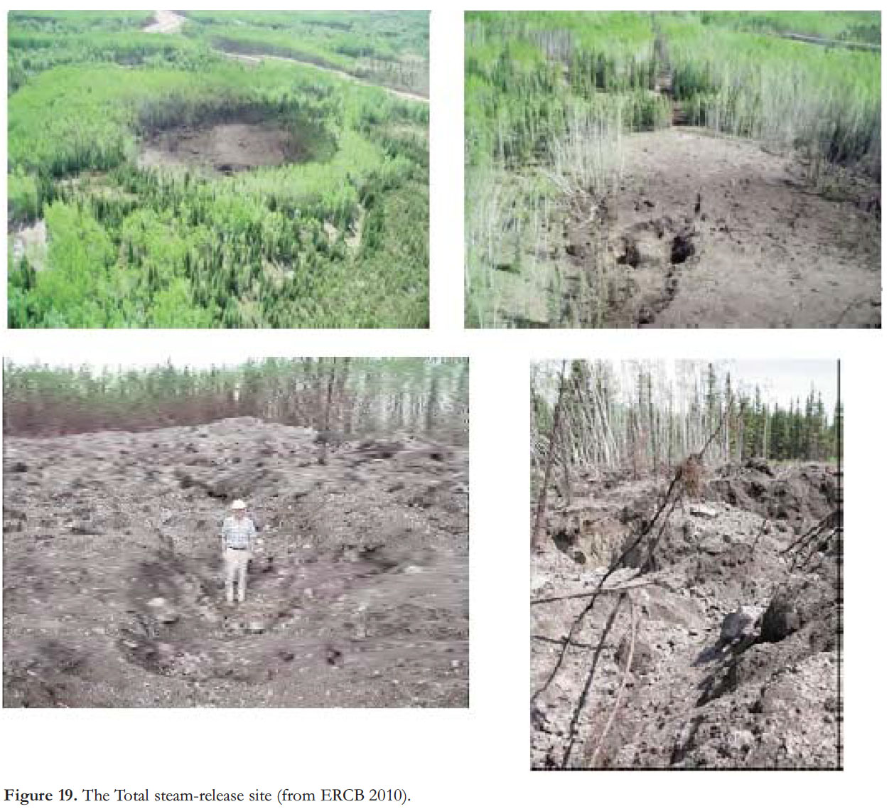
53 Not everything always goes as planned. “On May 18, 2006, at about 5:15 a.m., a catastrophic release of steam occurred at the Joslyn Creek thermal in situ oil sands scheme (Joslyn Creek), located about 60 kilometers north of Fort McMurray” (ERCB 2010, p. 1). The steam escaped at the surface, causing the development of a large crater 125 by 75 m across (Fig. 19). Projectiles travelled up to 300 m horizontally from the main crater and a plume of dust about 1 kilometre long stretched to the southwest of the release point. There was no loss of life or injury, and there were no harmful gaseous emissions.
54 A detailed examination and modeling of this event by staff at Total E & P Canada Ltd and a review by the ERCB led to the following conclusions. It was determined that Total was operating the steam chamber at higher pressures than had been approved. Under these high pressures the steam chamber encountered a gas pocket below the Clearwater caprock. This led to a localised build-up of pressure, and because the caprock contained silty and sandy layers it was not as coherent and continuous as it was presumed to be, resulting in a sudden shear failure, with steam released through a new vertical fracture. Once the steam established communication with the overlying aquifer, the sudden pressure drop led to rapid vapourization of the formation waters, and this provided the explosive energy for the breakthrough.
 Display large image of Figure 18
55 Over the long term there is potential for land subsidence over completed in situ oil sands projects. The SAGD process could result in the removal of all fluids from the reservoir volume, a process termed ‘voidage’ (Griffiths et al. 2006, p. 88). Complete replacement of the pore fluids by groundwater migration is anticipated to take decades, a time frame that is unlikely to prevent compaction and settling of the sands.
56 Clearly a detailed knowledge of the architecture of the bitumen-bearing layers and the water-charged aquifers, in addition to the petrology, distribution and integrity of the aquitards, is essential for the safe operation of subsurface oil sands projects (Hein et al. 2013, p. 13). Bellman (2010), Fustic et al. (2008), and Hubbard et al. (2011) provided examples of the kind of subsurface work now being carried out. At the shallow depths that are characteristic of oil sands operations, 3-D seismic can provide high-resolution imagery of the lithologies, and these can be interpreted in terms of petrological and hydrogeological properties by correlation against data obtained from wireline logs. For example, Bellman (2010) demonstrated how seismic data may be inverted to determine fluid saturation characteristics. In the case of the Total blowout (May 18, 2006), the assessment of the integrity of the Clearwater aquitard by Total E & P Canada was found by ERCB to have been inaccurate, which highlights the need for the best available geological base from which to operate oil sands projects.
Disposal of Used Water in Deep Aquifers
57 Disposal of process water in deep groundwater systems is a common practice in Alberta. In northeast Alberta the saline water system permeating the Devonian section underlying the oil sands is regarded as a suitable disposal target. Rogers (2012) noted that the ideal disposal formation has three main attributes: 1) Excellent near-well bore permeability; 2) large, regionally connected pore volumes; and 3) vertical and lateral containment for long-term storage. He proposed that carbonates of the Middle Devonian Elk Point Group (Keg River Formation) meets these criteria in selected locations. The Elk Point Group lies some 200 to 400 m below the McMurray Formation (Fig. 3) and consists of a carbonate-evaporite succession, in which dolomitization and evaporate solution has created a system of vuggy porosity showing excellent permeability characteristics. Similarly, Barson et al. (2001) suggested that the Winnipegosis–Keg River aquifer, which is contained by the Prairie Evaporite aquiclude, would make an excellent disposal target. Solid wastes (salts, sludge) are disposed of in landfills.
58 Data compiled by Griffiths et al. (2006, p. 106) indicate that water disposal rates at individual in-situ projects may amount to as much as 2.4 x 10⁶ m3 /yr. Disposal operations are managed by individual companies, and although this is regulated by the ERCB, there is practically no information available in the public domain that discusses the geological or hydrogeological implications of this practice.
End-pit Lakes
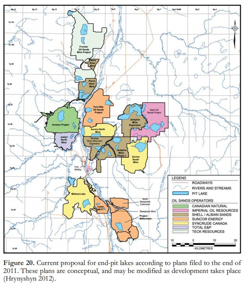
59 It is anticipated that even with the successful reclamation of the tailings ponds there will remain large volumes of mature fine tailings (MFT) and process affected water (PAW) that will require a method of final disposal. The proposed solution is to construct a large number of what are termed ‘endpit lakes’, to be established in mined-out areas (Hrynyshyn 2012). Some 30 pits have been proposed to date (Fig. 20). They are to be lined with oil sands by-products at the base of the pit, and filled with surface and groundwater from the surrounding reclaimed landscape. These pits are intended to be permanent; it is therefore part of the plan that they will develop viable ecosystems for fish, plant life and the ambient wetland biota, and that they become an integral part of the regional aquatic system. A 100-year timeline is anticipated for completion of the restoration process (Hrynshyn 2012). As discussed at length by the Royal Society of Canada Expert Panel (2010, p. 130–135), end-pit lakes for the oil sands mines are a largely unproven concept, with numerous questions remaining regarding the long-term stability of these artificial systems, although as discussed in Hrynshyn (2012) there is useful experience to draw upon from a history of end-pit lakes constructed for coal and metal mines (although these are characterized by different tailings chemistries). For example, will naphthenic acids and PACs decompose or migrate? And how will such changes in river and lake chemistry affect fish populations? Current studies summarized here regarding the leakage of PAW from tailings ponds indicates that existing engineering practices are resulting in reasonably effective containment of pollutants in the tailings ponds, but these studies have not been able to deal with time scales of decades or longer because the issues have not existed that long, and they do not relate to the long-term evolutionary history of waters in lakes that have yet to be constructed. The end-pit lake remains a concept requiring much further study, and one that could prove expensive to manage in order to minimize long-term pollution issues.
 Display large image of Figure 20
FUTURE DIRECTIONS
60 Alberta Environment and Sustainable Resource Development has now initiated several important monitoring and study programs, including the Regional Groundwater Monitoring Network, which is part of the Lower Athabasca Regional Plan, announced on 22nd August 2012. Fennell et al. (2011) described the evolution of the plan, which is to include the measurement of ‘indicators’ to enable the tracking of changes to the groundwater system (p.5):
61 A regional network of wells has been established to support the Groundwater Monitoring Network, in which these and other indicators will be tracked in order to monitor changes (Fig. 21). Work is underway to establish a reliable system of limits and of triggers that would indicate a pollution problem and indicate the need to initiate action. As Fennell et al. (2011, p. 6) noted: “Our knowledge … is still developing as new information is generated from environmental impact assessments and monitoring initiatives. By no means has the area’s complex groundwater interactions, and potential effects to surface water bodies, been resolved.”
62 On 17th October 2012, the Government of Alberta announced the formation of the Alberta Environmental Monitoring Management Board, acting on the advice of several advisory panels, the work of which is reported elsewhere in this issue (Miall 2013; Wallace 2013). The scope and shape of this new agency remains to be determined at the time of going to press, but as a body to collate and release scientific data and to provide analysis independent from government and industry, this agency should be able to set a standard for best practices and provide the necessary reassurance to the public that the Alberta Oil Sands are operating under practical, world-class, environmental standards. A considerable body of hydrogeological work is being carried out as part of the Environmental Impact Assessments process, but remains unpublished in government files. The public is largely unaware of the large volume of this type of scientific work being carried out by the corporate sector to meet regulatory requirements. Some of the hydrogeological work has been referred to in this paper. One of the functions of the new agency will be to evaluate the accuracy and reliability of this work, to analyse it to ensure that it meets the highest scientific standards, and to synthesize and interpret it for the benefit of the industry, government regulators, and the public at large.
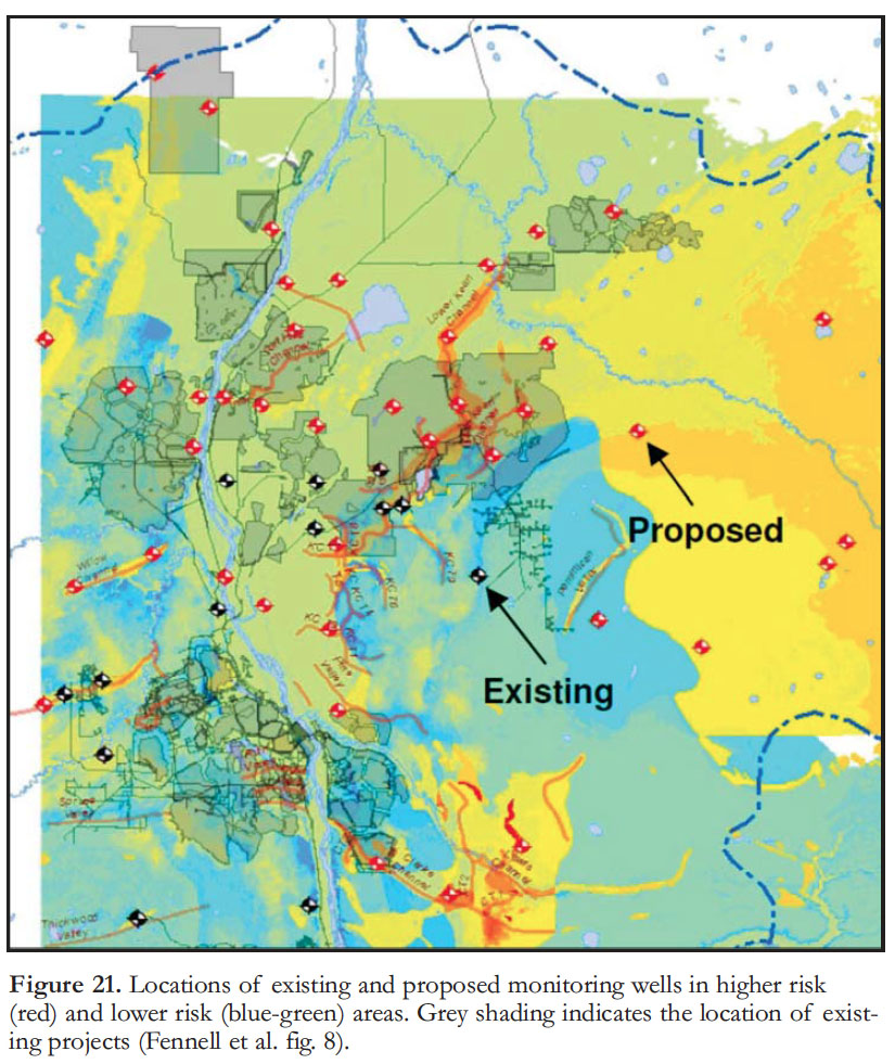 Display large image of Figure 21
The online Oil Sands Environmental Management Bibliography maintained by the Cumulative Environmental Management Association was extremely useful in locating critical reports and publications for this paper. I am very grateful to Jon Fennell of Integrated Sustainability Consultants, Paul Martin of Conoco Phillips Canada, John Brogly, Director of Water for Canada’s Oil Sands Innovation Alliance, Ron Wallace, Vice-Chair of the Alberta Environmental Monitoring Management Board, and two anonymous journal reviewers for their detailed reviews and comments, and for providing me with additional information and key references, although I take full responsibility for any errors or omissions that remain in this paper.