Column
The Tooth of Time:
Charlie Roots
1 Charlie Roots is a 56 year old field geologist with the Geological Survey of Canada (GSC) who lives in Whitehorse and is based at the Yukon Geological Survey, a territorial government organization. This is the story of my three brief encounters with Charlie, each separated by an hiatus of more than 15 years. Our most important and recent encounter was wordless—no meeting, no phone call, no email—the perfect crime. Now, I must admit at the outset that when I learned in school that much of the Yukon had ‘escaped’ Pleistocene glaciation, I wrote it off for my purposes as an area of good soil and bad outcrop. I was mistaken.
2 In January 1977, I was in a bit of a jam. The previous summer, with a crew of six, I had mapped the East Arm of Great Slave Lake, NWT, a system of deep channels and bays extending 240 km into the Precambrian Shield (Fig. 1). Christie Bay, the third deepest column of freshwater in the world after lakes Baikal and Victoria, owes its existence to erosion by ice streams within the Laurentide Ice Sheet, guided by a canoe-shaped synclinorium of soft, nearly unmetamorphosed, sedimentary and associated igneous rocks of Orosirian (late Paleoproterozoic, 2.05-1.80 Ga) age. As mapped by Cliff Stockwell (Stockwell 1932, 1936), the synclinorium is a doubly-plunging upright structure, more tightly folded on its southeastern side, where it is broken by faults. One of them, the McDonald Fault, presents a linear escarpment that parallels the east arm and puts granitoid basement rocks against the soft sedimentary succession. Stockwell’s map accurately portrays the geology that he saw on the shorelines of the East Arm and accessible waterways to the south (Stark Lake, Murky Channel), but without aircraft support he was unable to map all the rocks as far south as the McDonald Fault. My thesis project on the sedimentary succession revealed only one flaw in Stockwell’s map: a major carbonate platform and ramp, the Pethei Group, had a demonstrably-isochronous basinal facies (Hoffman 1974) that he mistakenly assigned to the stratigraphically overlying Stark Formation. Following the discovery of an Orosirian continental margin in the Wopmay orogen to the west, to which the main part of the sedimentary succession in the East Arm is genetically related (Hoffman 1969), I had disastrously interpreted the foldbelt as an ‘aulacogen’, the failed arm of a rift system active at the creation of the continental margin, analogous to the Cenozoic Ethiopian Rift Valley, or the subsided Early Cretaceous rift arm at the head of the Niger Delta (Hoffman 1973).
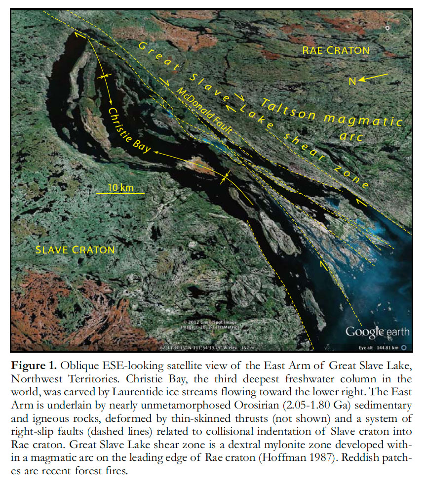 Display large image of Figure 1
3 The urge to systematically remap the East Arm arose during a year of teaching in the University of California at Santa Barbara, on unpaid leave from GSC. There, John Crowell introduced me to the San Andreas strike-slip fault system and related sedimentary basins (Wallace 1990). He had demonstrated not only the large displacement on the fault but also its strictly Neogene age (Crowell 1962), surprising many who thought that great faults exploit ancient lines of crustal weakness. In map pattern, the McDonald Fault system (Stockwell 1936) has strong similarities and significant differences compared with the San Andreas—it is a left-stepping right-slip system, linked not by rhombo-chasms (Carey 1958) but rhombic popup structures. Large strike-slip displacements (Thomas et al. 1976) would have to be estimated in order to restore the Orosirian sedimentary basin. An off season between three-year, 1:250,000-scale, mapping projects in northern Wopmay orogen offered the opportunity to remap the East Arm in 1976, my 10-year-old thesis project having been reactivated by GSC for this purpose. Straight away we found, between the East Arm and the McDonald Fault, a stack of recumbently-folded basinal-facies thrust nappes, refolded by the doubly-plunging upright folds (Hoffman et al. 1977). The refolded nappes extend for 200 km along strike. They were the first nail in the coffin of the aulacogen concept as applied to the East Arm of Great Slave Lake, which eventually emerged as a collisional indentation structure analogous to the Cenozoic Bay of Bengal – Indo-Burman Ranges area of the India-Eurasia collision zone (Gibb and Thomas 1977; Badham 1978; Gibb 1978; Hoffman 1987; Johnson 1990; Ritts and Grotzinger 1994). A host of other surprises emerged in the 19 weeks (and 1500 gallons of ‘kicker’ gas) it took to remap the East Arm. In a lifetime of geological travels, I never again encountered such a diversity of geological phenomena, exquisitely exposed, in so small an area (Fig. 2).
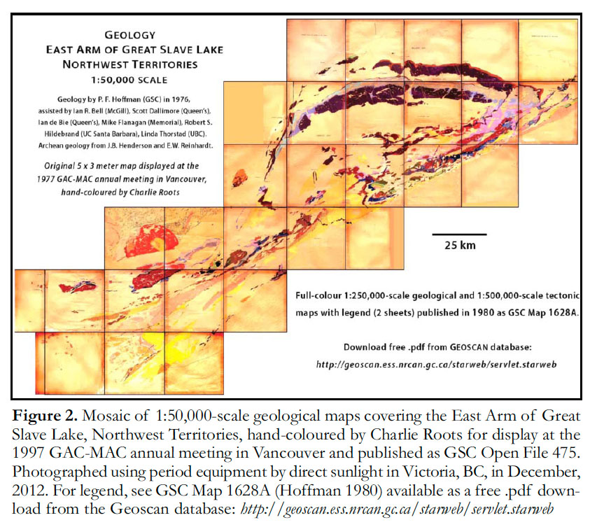 Display large image of Figure 2
4 The following January, a preliminary report on the East Arm was published (Hoffman et al. 1977) and compilation of twenty-five 1:50,000-scale geological maps (Hoffman 1977) was well underway. I hoped to display the maps at the GAC-MAC meeting in May, before embarking on the next mapping project in Wopmay orogen. I could finish the maps if I suspended my extracurriculars (e.g. running), but would still need help hand-colouring them for display—this was before digital map production and colour printers. The Winter Works program, a federal Liberal government initiative to reduce seasonal youth unemployment, provided help. Ira Stevenson, a congenial geologist who had mapped in Nova Scotia, northern Quebec and Labrador, managed the program at GSC. On cue, he came down to my office and introduced a broad-shouldered young man with sandy-red hair and a snaggletoothed grin. Charlie Roots was a third-year student from Ottawa at Dartmouth College in Hanover, NH, taking a semester break from classes. “Charlie is Fred Roots’ boy,” Ira told me by way of introduction, “Fred Roots of the Polar Continental Shelf Program.” In the wake of Sputnik, PCSP was launched in 1958 as a federal government program to encourage international scientific research throughout the Canadian Arctic by providing communications, equipment, accommodations, liaison with residents and air support at contract rates. PCSP was Fred Roots’ brainchild and he directed it for 14 years before becoming Science advisor to the federal government Minister of the Environment at the department’s inception in 1972. He began as a geologist. When the Norwegian-British-Swedish Antarctic Expedition of 1949-52 explored Queen Maud Land, conjugate to the east coast of southern Africa, the only thing British about the chief geologist was British Columbia, where Fred Roots was born and educated (BSc, MSc – UBC; PhD – Princeton). As the first modern and overtly international scientific expedition in the polar regions without territorial pretensions, it prepared the way for the Third International Polar Year, which became the International Geophysical Year, 1957-58 (Korsmo 2007; Roots 2011). In 1964, Fred Roots led the first Canadian Himalayan Expedition, which named and climbed high on an elegant pyramidal peak framed by glaciers, Sang-E-Marmar, which is nestled in the southern Batura Range (Figs. 3, 4) facing the Hunza Valley, in the Karakoram Mountains of northern Pakistan (Searle 1991). Whether as Founding Chairman of the International Arctic Science Committee or Canadian representative to the Antarctic Treaty, Fred Roots was a humble and soft-spoken bulldog for science and international science in the Polar regions.
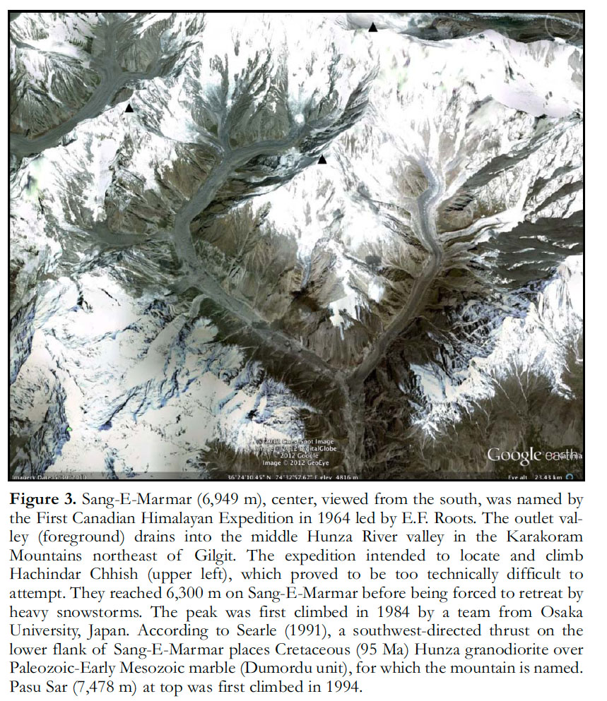 Display large image of Figure 3
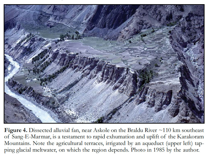 Display large image of Figure 4
5 Yet, Charlie Roots’ passion for high places was inspired by Noye Johnson at Dartmouth College. Johnson, who died in 1987 at the age of 57, was a remarkably versatile, field-oriented hydrogeologist, low-temperature geochemist, geochronologist, Cenozoic terrestrial stratigrapher and mammalian paleontologist (Naeser and Zeitler 1990). Starting in 1963, his systematic long-term study of a forested watershed-ecosystem in the White Mountains of New Hampshire yielded seminal insights on geochemical cycling, weathering rates and, coincidentally, ‘acid rain’ (Likens, Bormann and Johnson 1972). His interest in geochronology began even earlier with basic research on thermoluminescence, followed by regional-scale magnetostratigraphy and fission-track dating of detrital grains in Cenozoic sedimentary basins in active tectonic areas of Pakistan, Bolivia, Argentina and the southwestern United States. Above all, Noye Johnson was a man of action. Charlie was taking the semester off to work along side an Inuit contemporary, Zacharias Kunnuk from Igloolik, as labourers. Their job was to dig out an ice-core drilling camp (buried by snow) on the Devon Island Ice Cap in April, move it 350 km to the north in eight Twin Otter loads, rebuild it and core the Agassiz Ice Cap on Ellesmere Island down to bedrock. Later the same year, he would participate in reconnaissance mapping of Canada’s ‘Himalaya’, the St. Elias Mountains of SW Yukon (Fig. 5), when Kluane National Park was created. If he felt over-qualified for his Winter Works job with me—colouring a 5 x 3 metre map (Fig. 2) by hand with colour pencils— he didn’t say so.
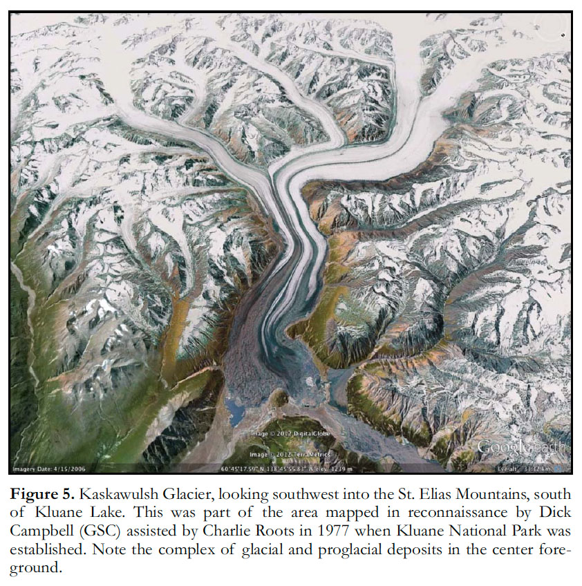 Display large image of Figure 5
6 The Spring on the eastern Arctic ice caps and Summer in the St. Elias Mountains set Charlie’s compass permanently on North. Returning to Ottawa for his PhD at Carleton University with John Moore and Al Donaldson, Charlie studied the Neoproterozoic Mount Harper Volcanic Complex as part of GSC’s Ogilvie Mountains Project (Thompson and Roots 1982). As a rift-related bimodal shield volcano associated with the breakup of Rodinia, the Mount Harper Group is unique on the Cordilleran margin of Laurentia (Roots 1987; Mustard and Roots 1997). His thesis won the Léopold Gélinas Award of the Volcanology Division of GAC. In 1987, Charlie moved to the Cordilleran Division of GSC in Vancouver, where he worked with Bob Thompson and Peter Mustard mapping the Dawson 1:250K sheet in west-central Yukon (Thompson et al. 1994). They enlisted geochronologist Randy Parrish in Ottawa, who obtained a rather imprecise U-Pb zircon date of 751 +26/-18 Ma for a rhyolite lava near the top of the volcanic complex (Roots and Parrish 1988). Working with paleomagnetist John Park, Charlie puzzled over evidence that the volcanic complex was rotated ~90° anticlock-wise around a near-vertical axis, compared with statistically coeval 780-Ma intrusions in the Mackenzie Mountains and the Canadian Shield (Park et al. 1992, 1995). He encouraged Peter Mustard to study the sedimentary rift-basin that preceded Mount Harper volcanism (Mustard 1991; Mustard and Roots 1997). Charlie pecked away at 1:50,000-scale mapping in the Ogilvie Mountains whenever funds were available.
7 In 1992, Charlie joined a 16-person expedition to climb and place a GPS receiver at the top of Mount Logan, to accurately determine the height of Canada’s tallest mountain as part of the 150th anniversary celebrations of GSC (Schmidt 1993). I had just left the organization and wasn’t in a celebratory mood when I met Charlie at the Cordilleran Roundup in Vancouver in January 1993. With characteristic lack of finesse, I suggested that GSC might better be seen as having less frivolous and more geological aims than the height of a mountain. Charlie responded that under the circumstances any positive publicity was good for GSC. The GPS site was anchored in rock, so that the change in elevation of the peak over time could be measured. Ten hand samples of granite had been taken at precise points between 3400 and 5900 m elevation for apatite fission-track analysis, to estimate the cooling (exhumation) rate in an area of anomalous tectonically-driven uplift. He was asked to participate because of his familiarity with the St. Elias Mountains. Moreover, the public was more impressed by the size or shape of a mountain than by its mode of origin, whatever the scientists thought. This last point was not lost on William Logan himself. In the competition to attract immigrants waged at the 1851 World’s Fair at the Crystal Palace, London, Logan’s geological display won hands down because the ‘Canadian’ rock specimens were neither rare nor beautiful, they were simply larger, with a strong emphasis on ores (Zeller 1987).
8 On October 4, 2000, Canadian Prime Minister Jean Chrétien announced that Mount Logan would be renamed Mount Pierre Elliott Trudeau after his recently-deceased predecessor. The announcement, symptomatic of the federal Liberals’ inattention to western Canadian public opinion, was openly opposed by First Nation leaders, the Yukon Minister of Tourism and member of the Geographical Names Board of Canada, surviving relatives of Sir William, prominent academics, and the presidents of national geographical and geological societies. As a compromise, it was proposed that a secondary peak on the high plateau of Mount Logan be renamed instead, and Charlie Roots was consulted on this by a National Post reporter because of his first-hand knowledge of the mountain. Had I known, I would have suggested they rename Mount Harper.
9 Charlie wrote to me a few days after our confrontation at the 1993 Cordilleran Roundup, restating his arguments. At the end of the letter, he added that “the right conditions to propose a thesis project on the [Neoproterozoic] sedimentary succession that overlies the Wernecke Supergroup are coming around again. The succession is called the Pinguicula (Eisbacher, GSC Paper 80-27), or Fifteenmile Group (Mustard, Roots, Bob Lane work), but has never been understood nor systematically described. What is needed is a strong student, willing to unravel the structure and measure sections in a field area spanning about 200 km, and a supervisor keen on mid-Proterozoic stratigraphy and regional reconstructions. Give me a buzz if such a project tickles your fancy.” All my resources were going to a nascent field project on the Neoproterozoic of northern Namibia and the following year I moved back east to Harvard. Years later, Noel James’ poster at the 2000 GSA meeting provided the impetus to compare Cryogenian glacial histories in Namibia and the Mackenzie Mountains, NWT (Yeo 1981; Eisbacher 1985; Aitken 1991; James et al. 2001). With U.S. federal government funding (NASA Astrobiology and NSF), we made an 18-camp reconnaissance of Cryogenian—early Ediacaran sequences and chemostratigraphy along the 500-km-long outcrop belt in the Mackenzie Mountains in three field seasons (Halverson et al. 2005, 2011; Shen et al. 2008; Hoffman and Halverson 2011). In 2004, I was accompanied by two Harvard PhDs, both of whom grew up in the Rocky Mountains. Galen Halverson (Montana ’96) was finishing his PhD on Neoproterozoic sequence and chemostratigraphy in Svalbard, Norway and Namibia; Francis Macdonald (Caltech ’01) was starting his on the Neoproterozoic-Cambrian succession in the Brooks Range of Arctic Alaska. At one camp, we densely sampled the type section of the pre-Cryogenian Little Dal Group (Gabrielse et al. 1973; Aitken 1981), a 2-km-thick carbonate-dominated sequence correlative with part of the Yukon succession Charlie had described in his letter. Finding the 0.80-Ga Bitter Springs isotope stage within the Upper Carbonate Formation of the Little Dal Group (Halverson 2006, Halverson et al. 2007) provided a target for regional correlation.
 Display large image of Figure 6
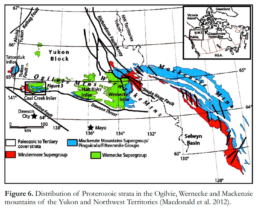
10 Francis Macdonald, a protégé of paleomagnetist Joe Kirschvink, had years of field experience before he started his PhD at Harvard. By the time he contacted Charlie Roots in February 2008, he had reinterpreted major Neoproterozoic successions in Arctic Alaska (Macdonald et al. 2009b), western Mongolia (Macdonald et al. 2009a) and the Tatonduk inlier (Tindir Group) astride the Yukon-Alaska international boundary (Macdonald et al. 2010a), based on aggressive field mapping and carbon isotope stratigraphy. He now proposed a regional study of Neoproterozoic (post-Wernecke Supergroup and Wernecke Breccia) and early Paleozoic rocks across the central Yukon (Fig. 6). In addition to his experience in correlative sequences to the east (Mackenzie Mountains) and west (Tatonduk inlier), he offered $30K in NSF funding (the lion’s share of the estimated annual cost) and research collaborations. Charlie, now living in Whitehorse, responded enthusiastically. With support from Don Murphy and Maurice Colpron, he convinced Grant Abbott to approve $5K of YGS funds for helicopter time, and GSC approved Charlie’s active involvement. Progress reports would be published in YGS’s annual Yukon Exploration and Geology series. Field geologists being more territorial than tomcats, not everyone was happy about the new neighbours. The truth was, the hunt for a Canadian Olympic Dam deposit had showered attention on the Wernecke Supergroup and Wernecke Breccias, while few people besides Bob Thompson and Charlie had shown interest in the Neoproterozoic of the Yukon in the 15 years since his first letter.
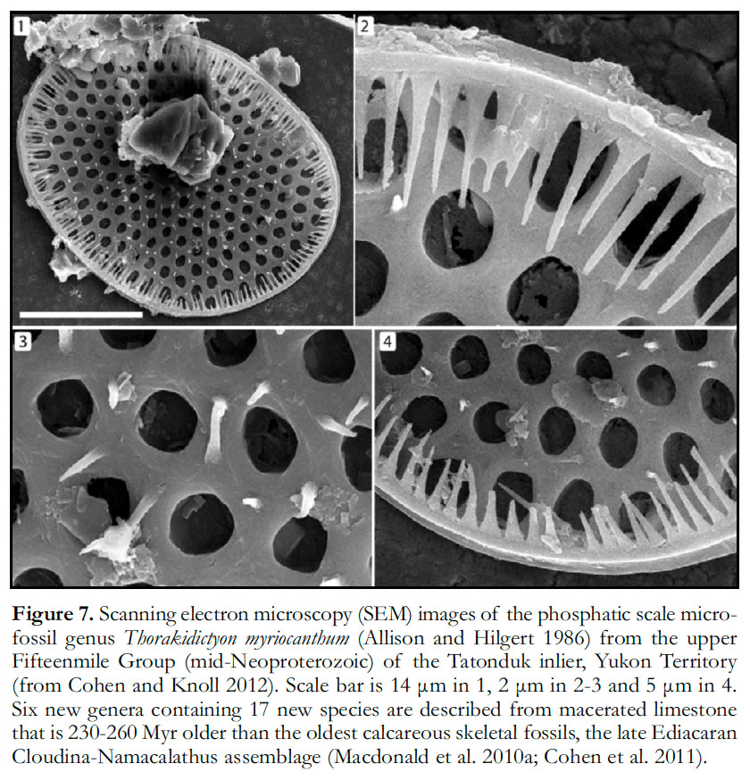
11 Macdonald’s project produced immediate results. The unconformity-bounded Pinguicula, Fifteenmile and Mount Harper groups make up a carbonate-dominated early Neoproterozoic succession about 5.3 km thick, which can be correlated in detail by means of sequence and chemostratigraphy across the Yukon and with coeval successions in eastern Alaska, NWT and western Nunavut (Macdonald and Roots 2010; Macdonald et al. 2011; Halverson et al. 2012). Collaborations with biogeo-chemist David Johnston at Harvard and geochronologists Mark Schmitz (a Sam Bowring protégé) at Boise State University in Idaho and Alan Rooney at Durham University in the UK, produced critical dates and geochemical tests. A U-Pb zircon date of 811.51 ± 0.25 Ma from a tuff in the upper Fifteenmile Group (Macdonald et al. 2010b) confirmed the early Neoproterozoic age of the world’s oldest skeletal microfossils, the exquisitely preserved and remarkably disparate assemblage of phosphatic scales (Fig. 7) from the Tatonduk inlier (Cohen et al. 2011; Cohen and Knoll 2012). The rhyolite in the upper Mount Harper Volcanic Complex, previously dated at 751 +26/-18 Ma (Roots and Parrish 1988), was re-dated at the same site at 717.43 ± 0.14 Ma (Macdonald et al. 2010b), a striking example of ongoing improvements in the accuracy and precision of U-Pb (IDTIMS) dating. This was more than a technical display. The volcanic complex is depositionally onlapped by massive and stratified diamictite, within which a brecciated tuff in the Mount Harper area was dated at 716.47 ± 0.24 Ma (Macdonald et al. 2010b). Lonestones occur below and above the tuff horizon, and the equivalent interval in the Hart River inlier to the east of the volcanic complex contains massive diamictite bearing multiply-striated boulders and stratified diamictite with glacial plow structures, confirming Charlie’s suspicion that the waning of Mount Harper volcanism coincided with the onset of Cryogenian glaciation (C.F. Roots, YGS project proposal, March 2008), equivalent to the lower Rapitan Group in the Mackenzie Mountains.
 Display large image of Figure 7
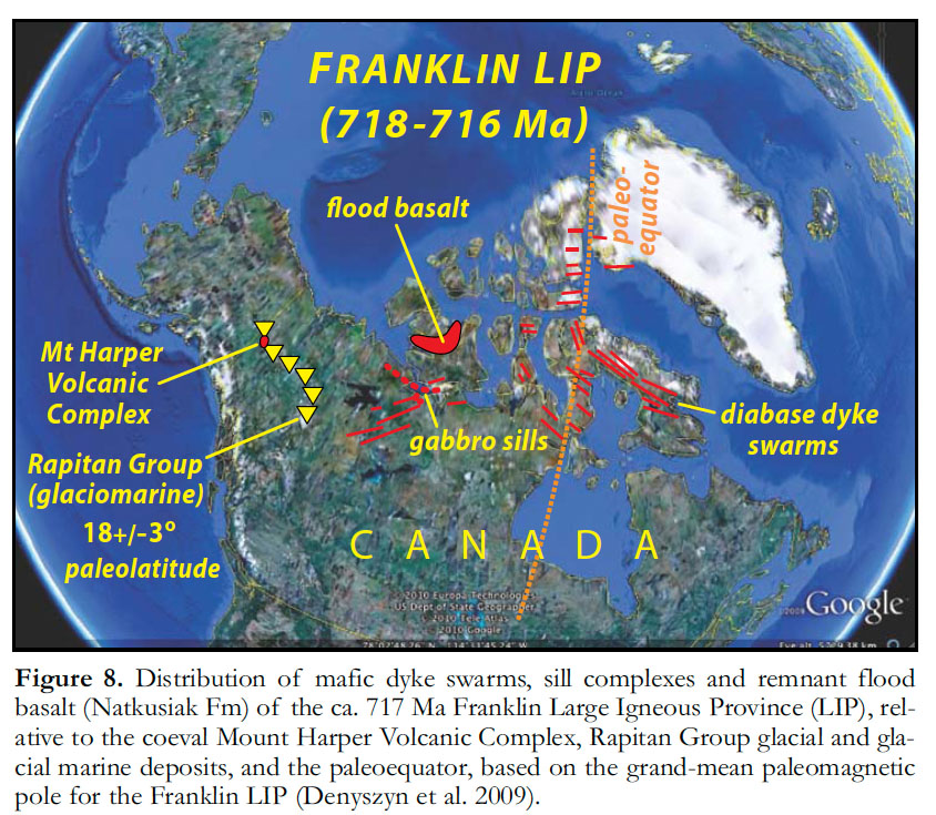
12 Farther afield, the dates showed that Mount Harper volcanism was coeval with the Franklin Large Igneous Province (LIP), a suite of mafic dyke swarms, sills and lavas recognized across the Canadian Arctic as far as NW Greenland (Fig. 8), dated on Victoria Island at 716.33 ± 0.54 Ma (Macdonald et al. 2010b). The highly-reliable grand-mean paleomagnetic pole for the Franklin LIP (Denyszyn et al. 2009) places the glacial and glacial marine deposits of the Rapitan Group in the Mackenzie Mountains at a paleo-latitude of 18° ± 3° (Evans and Raub 2011). By way of paleoclimatic comparison, during the Last Glacial Maximum in the Ethiopian Highlands, comparable in latitude and geographic setting, the lowest moraine formed at 3200 m above sea-level (Umer et al. 2004). The low paleolatitude for the Rapitan glaciation means that 716.5 Ma is not just the age of a local or even regional glaciation; it is a minimum date for the onset of a global glaciation, either a snowball Earth (entire ocean ice covered) or a ‘Jormungand’ climate state, in which a sinuous band of open water straddles the equator (Abbot et al. 2011). The Franklin LIP itself was emplaced squarely across the paleoequator on the windward margin of Laurentia (Fig. 9). In a world that was already cold because the unusual preponderance of low-latitude continents maximized both silicate weathering and the planetary albedo, the eruption of large basalt plateau in an area perpetually soaked by onshore tradewinds is a plausible trigger mechanism for runaway glaciation from a climate model (GCM) perspective (Goddéris et al. 2003). This scenario is being tested by parallel Sr and Os isotope stratigraphy (Rooney et al. 2012): enhanced basalt weathering drives both systems to less radiogenic values, Os more rapidly because of the 10-100-fold difference in the residence times of Sr and Os in seawater.
 Display large image of Figure 8
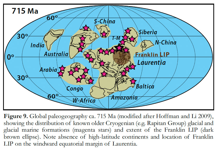 Display large image of Figure 9
13 Closer to home, the counterclockwise rotation of the Mount Harper paleomagnetic pole is somewhat smaller (~67°) when compared with the Franklin pole than with the 780 Ma pole (Park et al. 1992), but the tight synchroneity between the former rules out polar wander, true or otherwise. The Mount Harper Volcanic Complex and potentially the entire Yukon Stable Block evidently underwent a large counterclockwise rotation relative to cratonic Laurentia, a rotation that has long been conjuctured (Eisbacher 1981; Aitken and McMechan 1991; Abbott 1996) and which must be accounted for in any reconstruction of older structures, like the NNW-side-down normal faults that control early Neoproterozoic depocenters and facies in the Ogilvie Mountains (Macdonald et al. 2012). For over 40 years, Neoproterozoic rocks in the Cordillera have been viewed as the initial deposits of an early Paleozoic Cordilleran continental margin (e.g. Stewart 1972; Ross 1991), despite evidence that the margin did not exist before latest Ediacaran time (Bond and Kominz 1984). These rocks have a long and complex history, which influenced subsequent developments but cannot be explained by them (Macdonald et al. 2012). They have their own story.
14 YGS appears to be happy with the Neoproterozoic initiative—their contribution to Macdonald and his Harvard team’s helicopter costs doubled to $10K/year in 2009, and when Galen Halverson moved to McGill University from Adelaide in 2010, YGS provided an additional $10K/year enabling the two teams to join forces, funded primarily by NSF (Macdonald) and NSERC (Halverson). Their field work has not been limited to the Yukon: the Mackenzie Mountains have provided their share of excitement (Halverson et al. 2011; Johnston et al. 2012; Rooney et al. 2012). On either side of the continental divide, teams of grateful geologists camp out at Charlie and his wife Mary Ann’s house in Whitehorse on their way to and from the mountains. Through relentless pursuit of research partnerships, regardless of nationality, he brought sunlight to the Neoproterozoic of central Yukon, which now glitters on the international stage.