Column
The Tooth of Time:
Alfred Wegener
1 One hundred years ago last January, a rising young German meteorologist presented a startling new vision of crustal history at a meeting of the recently founded Geological Association (Geologische Vereinigung) in Frankfurt. The talk did not bring pleasure to its listeners. Not yet 32, Alfred Wegener had already published in several branches of meteorology and his admired textbook, Thermodynamics of the Atmosphere (Wegener 1911) showed him to be unusually skilled at synthesis. But he was unknown in geology and had only been seriously reading the geological literature for about four months (Fritscher 2002). Nevertheless, so many published facts seemed inexplicable if his theory was wrong, that he submitted the text of his talk to the Geological Association under the brash title, The Origin of Continents (Wegener 1912a). He proposed that geological interpretations would be greatly simplified if continents were allowed to undergo large relative horizontal displacements. The continents of today are the fragments of an ancestral land-mass that rifted apart progressively in Mesozoic and Cenozoic time, allowing the Atlantic and Indian ocean basins to grow at the expense of the Pacific. Not satisfied, he wrote an expanded version under the same title that was published in a leading geographical journal in three installments (Wegener 1912b; Jacoby 2001). From the start, geographers were as engaged as geologists in the controversy over continental drift. But with war clouds looming over Europe and RMS Titanic hogging the headlines, it would be ten years and three editions of his subsequent book, The Origin of Continents and Oceans, before Wegener-bashing began in earnest (Le Grand 1988; Newman 1995; Oreskes 1999).
2 Wegener himself left for Greenland (for the second time) in June of 1912, where he and the Danish explorer Captain J. P. Koch would winter over for the first time ever on the inland ice, near its eastern margin at 77°N. They drilled to a depth of 25 m with an ice auger and measured temperature at various depths and its variation over the winter (Dansgaard 2004). The following summer, they would make the first crossing of Greenland at its widest (and highest) part, Wegener all the while taking glaciological and atmospheric measurements and photographs. The trek and its harrowing finale have dramatic ingredients rivaling those of Shackleton’s Endurance expedition two years later, but writing thrillers was not in Wegener’s nature. Living them was.
3 This year, there will be many articles commemorating Wegener’s first (and best) papers on continental drift, as there were in 1980 on the centenary of his birth. A four-volume treatise on The Continental Drift Controversy by the American historian Henry Frankel will be published this year by Cambridge University Press. Yet, alone among leading scientists in the 20th century, Wegener’s professional standing 40 years after his visionary contribution was that of a minor figure of strictly historical interest (Greene 1984). In 1952, he was remembered only for having conceived the Wegener-Bergeron-Findeison process of ice-crystal growth in mixed phase clouds, and as the leader of a bold glaciological expedition to Greenland in 1930-31, the scientific success of which came at the cost of Wegener’s life. But between 1954 and 1960, paleomagnetic poles of Permo-Carboniferous, Mesozoic and Cenozoic age from different continents were obtained as a test of continental drift (Irving 1988; Creer and Irving 2012). The results vindicated Wegener and opened the way for the plate tec-tonic revolution.
4 Alfred Lothar Wegener was the youngest of five children, three of whom survived infancy. Their father, a theologian and classicist, was a teaching director at an academic preparatory school in Berlin, the newly-designated German capital with a population of just over a million. The family vacationed near their mother’s village in the deeply-forested glacial lake district north of the city (Schwarzbach 1986). Unlike his lanky siblings, sister Tony and brother Kurt, Alfred was of medium height and calm demeanour. The brothers were drawn to nature and Alfred majored in astronomy (Kurt in geophysics) at the Humboldt University of Berlin, spending summer semesters in Heidelberg, where he learned how to drink, and Innsbruck, where the brothers tested their fitness and resolve in the Alps. After completing his doctoral dissertation in computational astronomy in 1904, Alfred Wegener, switched his focus to meteorology. As he explained, astronomy was a mature science and new discoveries would require mathematical wizardry or access to the best instruments, plus an indoor temperament, none of which he possessed (Schwarzbach 1986). Meteorology was then an exploratory science, employing kites and balloons to study the formation of clouds and precipitation, the origin and development of cyclonic storms, optical phenomena of high latitudes, and the recently-discovered upper atmosphere. Alfred was invited to join his brother as a ‘technical aide’ at the Aeronautical Observatory outside Berlin. In early 1906, the brothers monitored an air mass aloft for 52 hours, then a new world record for continuous air travel in a balloon.
5 The allure of the interior of Greenland to the meteorologist can be found in the King’s Mirror, a father-toson educational guide written in Norway in about 1240, a century before the collapse of the Norse settlements in Greenland: “For it is the nature of the inland ice to produce a continuous, cold current of air, which drives away the storm-clouds from its face, so that the sky is generally clear. But the neighbouring countries often have to suffer for this. For all the regions which are near get bad weather from this ice, because all the storms, which the glacier drives away from itself, fall upon other countries with violent gusts.” (Georgi 1934). Alfred Wegener’s first opportunity came in 1906 as part of the 28-man Danish Danmark expedition led by Ludwig Mylius-Erichsen. They would spend two years in northeast Greenland at anchor in a fjord near 77°N on a coast that is all but inaccessible by sea because of the arterial discharge of summer sea ice from the Arctic Ocean. Wegener was responsible for sending up kites and tethered balloons to elevations of 3000 m, the first such experiments at high latitudes (Schwarzbach 1986). One of the objectives for the full summer of 1907 was to map the uncharted coastline between 75°N and Peary Land, above 82°N, and westward along the north coast of Greenland. In the Spring, two sled parties travelled north to Independence Fjord at the foot of Peary Land. Wegener and the Dane Johan Peter Koch mapped the north coast and made it safely back to anchor. The other party, led by Mylius-Erichsen and two companions (one a Greenlander) were stranded in a deep fjord by sea-ice breakup. They were apparently forced to wait for freeze-up months later and died of starvation and exposure while ascending the ice-sheet margin in winter for the sled journey back to base (McCoy 2006). Only the Greenlander’s body was found (by Koch), and with it a sketch of the last stretch of Greenland coast to be mapped. It cannot be said that Wegener was henceforth unaware of the dangers of his work.
6 On the strength of his Greenland results (Wegener 1909), Wegener took a teaching position in 1908 (on ‘soft-money’ for the first seven years) as the only meteorologist-astronomer in a small physical sciences department at Marburg, in the hills bordering the Rhine River north of Frankfurt. He renewed acquaintance with the 62-year-old Wladimir Köppen, who had formerly been head of the German marine weather service based outside Hamburg and who had provided Wegener with kites and advice before his first Greenland expedition. Köppen was a third-generation Russian intellectual of German descent, who began as a botanical geographer (he studied the botanically diverse Crimean Peninsula) and later coordinated the making of regional-scale weather maps (synoptic meteorology) in St. Petersburg, before taking the directorship at Hamburg five years before Wegener was born (Greene 2008). By the time Wegener knew him, the gregarious yet prolific Köppen (over 500 papers) was an acknowledged sage in synoptic meteorology, founder of a leading journal (Meteorologische Zeitschrift) and ‘observatory meteorologist’, free from weather forecasting to do whatever research he pleased. Much of his time was dedicated to the world climate-vegetation map and classification system, which he continually revised throughout his long life. This background would prove critical when Wegener stumbled into geology three years later. Of more immediate interest to Wegener was Köppen’s 16-year-old daughter Else, who he would marry upon returning from his second Greenland expedition in 1913. During the expedition, Else Köppen would spend a year in Oslo as a tutor at the home of Norwegian physicist and dynamical meteorologist Vilhelm Bjerknes, who wrote the basic equations used in atmosphere-ocean general circulation models. She shared her father’s gift for languages, later translating two of Bjerknes’ books from Norwegian to German, as well as J.P. Koch’s Danish-language account of the 1912-1913 Greenland Expedition with Wegener (Koch 1919). It is from Wegener’s letters to father and daughter Köppen that we glimpse what was going through his mind during the furious months in which he conceived and wrote up The Origin of Continents, while simultaneously preparing for Greenland (Wegener 1960; Schwarzbach 1986; Fritscher 2002).
7 But first, what was the prevailing view that Wegener’s theory challenged, and what was the knowledge-base from which his challenge arose? It was widely believed that continents and ocean basins are primordial features (Suess 1904; Chamberlin and Salisbury 1909; Willis 1910). This conviction was reinforced by global oceanographic surveys in 1872-77 (English Challenger, German Gazelle and American Tuscarora) demonstrating the Earth’s bimodal elevation frequency, and simultaneously by gravimetric and geodetic surveys in the western U.S. and elsewhere that confirmed the principle of isostasy (i.e. an elastic crust that floats on a fluid medium). A continent can neither rise from the abyss or sink to abyssal depth spontaneously. The mass excess of its elevation is compensated by a mass deficit at depth. If it were to move sideways, it would have to drag its moorings along with it, which was thought to be absurd. Isostasy cut both ways however: it rendered physically implausible the land ‘bridges’ invoked by geologists to account for ancient floral and faunal similarities between continents now far apart (Neumayr 1895; Suess 1904).
8 There were a few renegades against fixed continents: one was the English geologist and geophysicist The Reverend Osmond Fisher, another was the American glacial geologist and Harvard dropout Frank Bursley Taylor (Rupke 1970). In 1879, the astronomer George H. Darwin (son of Charles) had calculated that the Moon could have originated by fission from the Earth when the Earth’s rotation rate was equal to one complete revolution every five hours. He suggested that the event had occurred within the time frame of the stratigraphic record but that the wound itself would have healed over. Fisher suggested instead that the Pacific Ocean basin was the residual scar. Furthermore, the sudden inflow of the fluid substrate toward the cavity caused “what was left of thegranitic crust to be broken up into fragments, now represented by the continents. This would make the Atlantic a great rent, and explain the rude parallelism which exists between the contours of America and the Old World.” (Fisher 1882). Continental breakup as a consequence of a Moon-forming event still had advocates even in Wegener’s day (e.g. Pickering 1907).
9 The self-funded Taylor (1910), Wegener’s closest antecedent, used The Face of the Earth (Suess 1904-24) as his starting point. As a narrative synthesis of global tectonic geology, The Face of the Earth in five volumes and 2403 pages has no rival. Its author was fond of saying that when he showed the final product to his assistant, whose duty for 20 years had been to fetch books from the library, the man exclaimed, “Is that all you got out of the books I brought you?” (Hobbs 1914). Both Taylor and Wegener’s presentations of the geology they sought to explain are almost verbatim from Suess, but the geology each selected was different—for Taylor the Tertiary (Alpine) mountain belts, for Wegener the contrasting types of ocean basins. Regarding the former, the Viennese professor could claim at least one fundamental insight and a grand generalization (Brouwer 1981). The insight, which stemmed from the Alps, is that mountain belts are dynamically asymmetrical: most of their mass moved subhorizontally towards one side or the other (Suess 1875). At the time, all theories of the origin of mountain belts predicted crude symmetry. The triumphant discovery and elucidation of the grand-scale ‘nappe’ structure of the Alps (Bertrand 1884; Schardt 1893; Lugeon 1901) followed after Suess’s ‘little book’ (Suess 1875), making it legendary. Suess’s grand generalization was that the direction of thrusting in North America and Europe was generally northward (including northwest-ward or northeastward in oblique ranges like the Appalachians and Cordillera), whereas in Asia it was generally southward (southwestward or southeastward in ranges like the Zagros and Hindu Kush). Taylor (1910) seized upon the generalization and proposed that contraction across the ‘Tertiary’ mountain belts was accommodated by rifting and separation of continental blocks in the polar regions, exemplified by the departure (literally) of North America from Greenland in a direction parallel to Nares Strait. He recognized the Atlantic Ocean as having rifted apart symmetrically with respect to the Mid-Atlantic Ridge (known from Challenger), concluding that the Ridge has remained fixed while the Americas moved westward from it in the Tertiary, while Africa along with Arabia and peninsular India moved eastward from the Ridge in pre-Mesozoic time. Like Wegener, Taylor (1910) appealed to rotational and tidal forces to account for these motions, a viable hypothesis only under unrealistically small yield strengths for the fluid medium. Wegener devoted a paragraph at the start of each of his 1912 papers to Taylor’s hypothesis, but it seems unlikely that he knew of it in advance of his own rather different conception in the Fall of 1911.
 Display large image of Figure 1
10 Wegener’s office mate had received a world atlas with up-to-date bathymetric maps for Christmas in 1910 (Greene 1984). They noticed (letter to Else Köppen) that the east coast of South America appears to fit against the west coast of Africa, “as if they had once been joined” (Schwarzbach 1986). The fit is even better, Wegener continued, if the tops of the respective continental slopes are matched instead of the present coastlines. “This is an idea I’ll have to pursue”, but he did nothing more with it until the Fall of 1911, when he “quite accidentally” (Wegener 1929) came upon a treatise on continental paleogeography (strata, flora, fauna and climate), compiled by a German high-school teacher only two years older than himself (Arldt 1907). Here, Wegener learned of the remarkable similarities in Mesozoic flora and fauna between Brazil and Gabon, and also of the concept of sunken ‘land bridges’ then widely invoked by geologists to account for such linkages. As a geophysicist interested in glaciology, he was more convinced than contemporary geologists that isostasy precludes land bridges from sinking to abyssal depth. When Wladimir Köppen gently advised him not to stray too far from what he knew, Wegener wrote back (in early December) that the geological linkages require either land bridges or continental displacements, but “a continent cannot sink, for it is lighter than that upon which it is floating. Therefore, let us, just for once, take [displacement] into consideration! If such a series of astonishing simplifications follow, and if it is shown that ‘rhyme and reason’ will now come to Earthhistory, why should we hesitate to cast the old view overboard?” (Fritscher 2002).
11 The rhetorical structure of The Origin of Continents did not change from the first lecture to the last edition of the book (Wegener 1912a, 1929). It is the ‘hypothetico-deductive’ approach. Wherever land-bridges were currently invoked, Wegener invites the reader to substitute rifting and drifting of continental rafts. If the results comprehensively simplify and rationalize geologic history, and if the process cannot be definitively ruled out on physical grounds, then the new hypothesis is not only justified but superior. He anticipates that further elaboration will necessitate modifications and that it will never be more than a working hypothesis until reliably proved by geodetics. For reasons best left to historians and psychologists, geologists are instinctively suspicious of the hypothetico-deductive approach.
12 The longer 1912 paper (Wegener 1912b; Jacoby 2001) came out in three installments: (1) geophysical arguments, (2) geological arguments, and (3) remaining geological arguments, present displacements and polar wobble. In (1) he introduces the elevation duality, gravity measurements and isostasy, thickness of the continental rafts, their composition, their plasticity in relation to that of their substrate, volcanism, and possible causes of displacement. Wegener did not distinguish between oceanic crust and mantle: the composition of the mantle was then unknown. He used Suess’s terms, ‘sial’ for the continental rafts and ‘sima’ for the substrate, assumed to be directly covered by abyssal sediments. He uses the term ‘crust’ as synonymous with ‘lithosphere’. He expends little space on causes, which he considers to be premature. “It will be necessary first to exactly determine the reality and the nature of the displacements before we can hope to discover their causes.” (Jacoby 2001). There is a goof in this section which must have influenced Wegener’s thinking because it is perpetuated in the 1st and 2nd editions of the book (Wegener 1915, 1920). It disappeared in the 3rd edition (Wegener 1922), the one translated into six languages at the time of the hysterical debate. Wegener begins the section on plasticity by observing that, “In my model the sialicblocks should be capable of horizontal motion in the sima.” An astonishing statement follows: “For this it is important that the melting point of sial is about 200-300° higher than that of sima, such that the latter is still fluid and the former is already frozen (Dölter 1906)”. Experimental petrology was evolving rapidly in the years before 1912 and Cornelio Dölter at Graz in Austria had studied the viscosities of silicate melts and the crystallization temperatures of rock-forming minerals (Yoder 1998), but by 1929 it was apparent that the melting temperatures of most quartz-bearing rocks are lower, not higher, than basalt (Larsen 1929). The yield strength of sima is greater than Wegener had been led to believe.
13 The geological arguments are the strongest part of the paper and surprise even today (Wegener 1912b; Jacoby 2001). He reviews the evidence for active rifting in the Rhinegraben and the Red Sea – East African rift system. He compares the structure and geological history of his Atlantic conjugate margins, estimating the age of opening of different segments and speculating on connections between South Atlantic opening and Andean contraction. His estimates are everywhere too young—Paleogene (actually Early Cretaceous) in the South Atlantic, Neogene (actually Jurassic) in the North Atlantic and Quaternary (actually Eocene) between NW Europe and Greenland. The last estimate in particular led him to predict that the separation rate between NW Europe and Greenland is ~2 meters per year and testable by geodetic experiment. His separation age being at least 100 times too young, the rate is too fast by the same multiple. In the next section, on Gondwanaland, his estimated separation ages for Africa–Madagascar, Australia–Antarctica, and Australia–India are broadly correct. Why did he insist that no ocean existed to the northwest of Europe in the Pleistocene? It is because ‘steppe animals’ (mammoth, whooly rhino, etc.) existed in Central Europe during Pleistocene interglacial times, but not during the Holocene. He infers a climate like southern Russia and western Siberia for Central Europe, which would be “implausible with the present ocean so close in the west”(Wegener 1912b; Jacoby 2001). It remains a sound argument, but for the human ‘overkill’ hypothesis. Next he turns to the ‘Permian’ glaciation, represented by “indisputable ground moraines” on “typically striated pavements” in Australia, South Africa, eastern India and South America. With continents in fixed positions, Permian ice sheets occurred across most of the southern hemisphere, while in the northern hemisphere no verified Permian glacial deposit exists anywhere. This represents “a hopeless riddle for paleogeography.” In Wegener’s continental reconstruction, not yet illustrated in a figure, the various ice sheets are brought together into an area no larger than that occupied by the Pleistocene ice sheets. He infers that this area was centered over the south pole, which would then have been located near the southern tip of Africa. The north pole would lie in the north Pacific Ocean, taking “everything mysterious away from the phenomenon.” The paper reaches its climax when Wegener contrasts the Atlantic–Indian and Pacific ocean basins, explicitly as described in the opening stanzas of Das Antlitz der Erde (Suess 1904). The Atlantic margins, with their “ragged shorelines and cut tablelands”, follow the inner sides of older mountain belts (Appalachians, Caledonides, Mauritanides, Cape Foldbelt). The same is true for the Indian Ocean, except west of the Indus River and east of the Bay of Bengal, where the active Eurasian mountain front “spills into the ocean” in the Makran and the greater Sunda arc. In the Pacific, smooth arcuate coastlines or volcanic chains parallel fold belts that are everywhere vergent toward the ocean. “No fold belt borders the Pacific from its inner side; no platform projects into the ocean.” He notes that the Pacific is on the whole deeper than the Atlantic, with correspondingly less calcareous abyssal sediments, and that Pacific volcanic rocks are less chemically evolved. These differences follow automatically from the hypothesis: “While the Atlantic opens, nearly all the Pacific margins approach towards its center; along its coasts widespread compression and convergence occur, but tension and rifting in the Atlantic” (Wegener 1912b; Jacoby 2001). Foreshadowing the Wilson cycle he writes, “the rift that once opened to form the Pacific and to compress the primevalcontinent [Pangea] from both sides, originated in oldest geological times, and that the resulting motion was long extinct when the forces (that formed the Atlantic) commenced.” Returning to the Atlantic, he suggests an explanation for seafloor topography. Since large areas of the seafloor are isostatically compensated, areas that are younger and hotter will be modestly elevated over those that are older and colder. “The depth variation appears also to suggest that the Mid-Atlantic Ridge should be regarded as the zone in which the floor of the Atlantic, as it keeps spreading, is continuously tearing open and making space for fresh, relatively fluid and hot sima from depth.” This is not seafloor spreading as we now know it—no oceanic crust is formed by partial melting of mantle peridotite. Rather, he visualizes the sima as being exhumed in a solid state, as it does in the transition to seafloor spreading on non-volcanic margins (Whitmarsh et al. 2001). It is close enough to seafloor spreading, however, that one is left to wonder why Wegener subsequently abandoned such a promising lead (Jacoby 1981). Had he not been deceived into thinking that the sima would readily accommodate the drift of tabular crustal bergs, would he not have tried moving the sima along with the sial? After all, he was not driven by any particular geodynamic mechanism (he admitted he had none), he was driven by the converging lines of geological evidence.
14 Wegener concludes the geological arguments with paleoclimatic (mainly floral) evidence for polar wander (i.e. true polar wander), which he assumes is as important as continental drift in accounting for observed changes in paleolatitude since the Permian glaciation. Moreover, he suggests that continental displacements were the cause of polar shifts, because “the pole of rotation must follow the pole of inertia”. He considers it premature, however, to interpret the ‘Lower Cambrian’ glaciations in Norway, China and Australia (read Cryogenian snowball Earth) in terms of polar wander. Wise man!The final and shortest section of the paper (Wegener 1912b; Jacoby 2001) concerns geodetic proofs (i.e. tests) of active continental displacement. He describes astronomical determinations of longitude by successive expeditions to particular sites in Greenland, and longitude differences between Europe and North America from Trans-Atlantic cables. Wegener came in for heavy criticism from geographers for suggesting that such data were consistent with displacement. A more charitable view is that Wegener was providing ‘proof of concept’ and a baseline for “astronomical positioning during the course of several decades.” Wegener concludes with a comment on polar wobble, discovered by the American astronomer Seth Chandler in 1891 and monitored since 1899 by the International Latitude Service. He suggests that a shift in the inertial axis would cause the center of the perturbation curve to migrate as well. He speculates that continental displacements might be the cause of the wobble itself. “This is because a perturbation once present must come to rest in spirals so that the pole of rotation and that of inertia will coincide as a consequence of the work it does in the Earth’s viscous interior. If the pole of inertia shifts, the pole of rotation moves out at a right angle and follows the perturbation curve, first with a large radius, then with a smaller and smaller one until it reaches the new pole of inertia” (Wegener 1912b; Jacoby 2001).
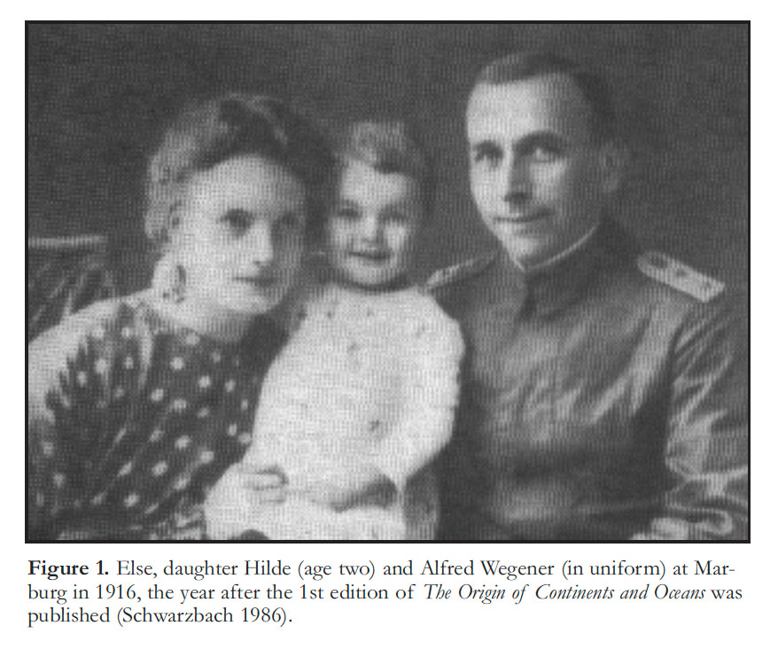
15 Returning to Marburg, spent but triumphant after his Greenland crossing of 1913 with Peter Koch, Wegener married Else Köppen. The following year the first of three daughters was born (Fig. 1). Alfred busied himself with reports from the expedition—observations on polarization of the upper atmosphere over Greenland; on dust devils on Iceland, which the four-man Koch expedition had traversed from north to south, Wegener crossing the Vatnajökull (ice cap) on horseback, as a field trial en route to Greenland (Schwarzbach 1986). Then came World War I. Wegener enlisted and served throughout the war (1914-18). He was wounded twice on the Western Front, the second time more seriously with a bullet lodged in his neck, requiring a lengthy period of convalescence in Marburg. During his recovery, he expanded the 32-page 1912b paper into a 94-page booklet, The Origin of Continents and Oceans (Wegener 1915). Much new detail was added to the geological arguments, and for this we can thank the fortuitous arrival in Marburg in 1914 of an adventurous young structural geologist named Hans Cloos. Before the war, Cloos had worked in the oil fields of Indonesia and in mineral exploration in German South West Africa (Namibia). He would go on to be a famous geologist, writer and illustrator, best known for his analogue (clay-cake) models of fault zones, for ‘granite tectonics’ (petrographic analysis of fabric development associated with pluton emplacement), and for an enduring classic in the romance of field geology, Conversations with the Earth (Cloos 1953). In it, he recalls:
16 “One day while I was teaching at Marburg a man came to me, whose fine features and penetrating, gray-blue eyes I was unable to forget. He had developed an extraordinary theory in regard to the structure of the earth. He asked me whether I, as a geologist, was prepared to help him, a physicist, by contributing pertinent geological facts and concepts. I liked the man very much, even though I was skeptical of his ideas. Thus began a loose cooperation on a subject in which the Red Sea rapidly assumed a central position.
17 “The man was Alfred Wegener.
18 “His hypothesis became famous all over the world, for it placed an easily grasped and sensational idea on a semi-scientific basis. His theory loosened the continents from the terrestrial core, and changed them into icebergs of gneiss floating on a sea of basalt. He let them float and drift, tear apart from and bump into one another. Fissures, rifts, graben were left where they had pulled apart; where they collided, mountains folded. ‘Just look at Arabia!’ Wegener cried heatedly, and let his pencil fly over the map. ‘Is that not a clear example? Does the peninsula not turn on Sinai to[ward] the northeast like a door on a hinge, pushing the Persian [Zagros] mountain chains in front of it, attaching them on the two hooks of Syria and Oman like drapes! In the rear, the Arabian table[land] has been torn off Africa. It has moved away from the Abyssinian angle, opening a rift 200-250 miles [320-400 km] wide, exactly the amount of narrowing suffered by the Persian mountain chains.’
19 ‘But the triangle of the Danakil in the southwest corner of the rift, how does it fit into your movement?’
20 ‘It is lava,’ Wegener replied,‘which welled up from the bottom of the graben.’
21 ‘Very well, but how can lava float on lava?’
22 ‘The lava does not float; it is carried by lighter blocks of gneiss that had been split off before.’
23 There was hesitation on the part of the geologist, quick repartee by the physicist. The Red Sea was only part of the general discussion ...”
24 On account of his injury, Wegener returned to service as a battlefield weather forecaster. Balloon ascents sparked his curiosity in meteors and impact craters, leading him to cratering experiments and a post-war book on the craters of the Moon (Wegener 1921). Even more specific to his wartime experience was a paper entitled, On the formation of hoarfrost on horse corpses. This from a man, who along with Koch, had man-hauled their last and dying Iceland pony on a sled, in hopes that the three of them might reach safety on the west coast of Greenland together (Schwarzbach 1986). After the war, Cloos moved to Breslau, where his doctoral students included his much younger brother, Ernst Cloos, who would later build up the geology department at Johns Hopkins University and approve without comment my request to translate the Geologische Rundschau paper (Wegener 1912a) to fulfill my scientific German requirement. Wegener never again found a geologist with whom he could work closely.
 Display large image of Figure 2
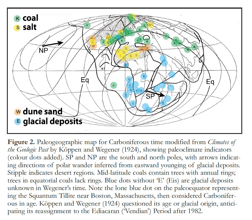
25 At war’s end, Wegener succeeded the 72-year-old Köppen as head of theoretical meteorology at the German Marine Weather Observatory in Hamburg, with teaching privileges at the new University of Hamburg (Schwarzbach 1986). Amidst the post-war chaos, Wegener enjoyed five years of high productivity. In addition to his book on lunar craters, Wegener wrote a thoroughly revised 2nd edition of The Origin of Continents and Oceans (Wegener 1920), which contains for the first time his iconic paleogeographic maps for the Carboniferous, Eocene and Quaternary on accurate stereographic projections. It was revised again for the 3rd edition in 1922, which became the chief vehicle of his notoriety when it was translated into English, French, Spanish, Swedish and Russian. This was unfortunate because the paleoclimatic argument, always the most compelling he had, was considerably shortened in anticipation of a new monograph with Köppen. Climates of the Geological Past (Köppen and Wegener 1924) is a synthesis of paleoclimate data from Neoproterozoic (‘Algonkium’) to present, re-analyzed in light of continental drift. Paleoclimatic indicators are plotted on 9 new paleogeographic maps (Fig. 2), ranging in age from Devonian to Pliocene. Gondwana is interpreted as having drifted westward over the south pole between late Devonian and early Permian time, based on eastward younging of glacial deposits. At the back of the book is a tip-in figure showing variations in solar radiation in summer at 55, 60 and 65°N latitude over the last 650,000 years, in which four pairs of insolation minima are identified with the four Quaternary ice ages recognized around the Alps (Penck and Brückner 1909). The figure was contributed at Köppen’s request by Milutin Milankovic, a Serbian engineer-turned-astronomer of Wegener’s age. Milankovic’s insolation curves live on; Penck and Brückner’s ice-age chronology does not. It is an injustice to history that Climates of theGeological Past remains available only in the original rare German edition: as a book, it has worn better than The Origin of Continents and Oceans.
26 The delayed reaction to Wegener and Köppen’s theory by geologists, geographers and geophysicists took place between 1922 and 1928. Discussion meetings were held in England (Anonymous 1923a), South Africa (Anonymous 1923b) and New York (van Waterschoot van der Gracht 1928). Reviews of The Origin of Continents and Oceans appeared in leading international journals, starting with a highly favourable one in Nature of the 2nd edition that I suspect was written by E. B. Bailey (Anonymous 1922). It concludes, “The revolution in thought, if the theory is substantiated, may be expected to resemble the change in astronomical ideas at the time of Copernicus. It is to be hoped that an English edition will soon appear.” Others were less kind. The reaction to Wegener has been a focus of attention by historians (including geologists), seeking reasons for the fury of Wegener’s critics (Greene 1984; Carozzi 1985; Marvin 1973, 1985; Wood 1985; Le Grand 1988; Newman 1995; Oreskes 1999; Schaer 2010, 2011; Frankel 2012). I will not go over it again here.108 Of more interest is the fact that Wegener’s theory had eloquent supporters among the geological élites: Edgeworth David in Australia, Gustaaf Mohlengraaf and Willem van der Gracht in Holland, Reginald Daly in America, Alex du Toit in South Africa, Emile Argand and Léon Collet in Switzerland, Edward Bailey and Arthur Holmes in Britain, in order of seniority. Daly, a Canadian geologist at Harvard, lobbied the Carnegie Institution of Washington for the funds that enabled du Toit to undertake a reconnaissance (his second) of South American geology in 1923 with the explicit purpose of testing Wegener’s trans-Atlantic correlations. The result was indisputable support for drift (du Toit 1927, see also du Toit 1921, 1937). The collisional interpretation of mountain belts, not much discussed by Wegener, was taken up in depth in Tectonics of Asia (Argand 1977), which put in mobilistic context the directionality (vergence) of orogenic belts recognized by Suess, and the nappe structure of the Alps—“Africa thrust into the heart of Europe” (Argand 1924). Tectonics of Asia was then unavailable in English but Argand’s message was conveyed to the English-speaking world with style and authority by Léon Collet (1925, 1927). However, where Wegener might have expected support, from those most engaged with the geological record of climate and ice ages, English meteorologist C.E.P. Brooks (1926) and Canadian geologist A.P. Coleman (1924, 1926) found nothing of value in continental drift. Wegener himself played an uncharacteristically passive role in the debate. For Wegener, drift was no longer new and he had written about it all that he knew. He had other ambitions to pursue.
27 Wegener’s first and only professorship came in 1924 when he accepted the chair in meteorology and geophysics at the University of Graz in southern Austria. The elderly Köppens had merged with the Wegeners in Hamburg and they moved together to the extreme southeast of German-speaking Europe. The period of hyper-inflation in Germany had ended; between 1924 and the Wall Street Crash of 1929, the Weimar Republic flourished. With better economic prospects for sponsorship, Wegener’s desire to lead his own Greenland expedition, thwarted by war and its aftermath, was rekindled. “We had almost settled down to a life of middle-class comfort ...” is the poignant way Else Wegener begins Greenland Journey: The story of Wegener’s German Expedition to Greenland in 1930-31 as told by members of the expedition and the leader’s diary (Wegener 1939). Ever since the 1912-13 expedition with J. P. Koch, Wegener saw the need for year-round atmospheric and glaciological observations at the center of the Greenland Ice Sheet, backed up by simultaneous observations on each coast. The opportunity appeared in 1928 when geographer and glaciologist Ludwig Meinardus at Göttingen invited Wegener to lead a Greenland expedition for the purpose of measuring the thickness of the interior ice sheet by means of explosion seismology, using techniques recently developed by Emil Wiechert also at Göttingen (Georgi 1934; Wegener 1939; McCoy 2006). The expedition would be sponsored by an organization founded in 1920 with the backing of German universities, colleges and learned societies to lessen the effects of economic distress on scientific activity, the Notgemeinschaft der Deutschen Wissenschaft (NDW). Wegener had been planning to return to Greenland with Koch but this had been forstalled by the 58-year-old’s death in Copenhagen just three months earlier. Wegener proposed that the seismology experiment and his intended research be combined, and this plan was enthusiastically adopted. The mid-ice station (elevation ~3000 m) would be established and supplied from the west coast, while the east coast station would be established independently in Scoresby Sound. (It was still in use as an airstrip when I had the good fortune to visit the Fjord Zone in 2004 with Eugene Domack, Galen Halverson and Adam Maloof.) The principle logistical challenge would be to transport equipment and supplies for the mid-ice station overland to the foot of the ice and up the steep slope of the ice sheet at its margin. Once on the plateau, propeller-driven sleds would replace the Iceland ponies of previous expeditions. Wegener immediately set about organizing a trial expedition for the summer of 1929 to select a site for the western station and a route onto the inland ice. The four-man 1929 expedition, Wegener’s third, was uneventful. A site at the head of Umanak Fjord near 71°N was selected for the western station. There would be no radio communication with two of the four men during their long winter at mid-ice station.
28 After laying up their motorized yacht in Godhavn, the men returned to Europe in November only to find the great stock market crash underway and the entire 1930-31 expedition in serious jeopardy (Wegener 1939). Two months of frantic fund-raising followed and by January 1930, NDW gave Wegener the green light. The 14-man expedition (3 would join in Iceland and 3 others would man the eastern station) left Copenhagen on April fools’ day and ran into trouble almost from the outset. They off-loaded their gear in Umanak Fjord in mid-June, five and a half weeks late due to bad weather and unseasonable sea ice. “This sealed the fate of the expedition”, wrote Kurt Wegener, who would leave Hamburg to assume leadership of the expedition in 1931. They ran into further delays hauling the motorized sleds onto the ice sheet, something they had been unable to practise the previous year as the sleds were new. The final upshot was that by the 20th of September the mid-ice and western stations were established and manned, but the mid-ice party was short of supplies for the winter. The agreement was that if supplies didn’t reach midice by 20 October, the pair would head back to the western station. But Wegener left the final decision to mete-orologist Johannes Georgi, who was paired with glaciologist and high-school teacher Ernst Sorge at mid-ice. Knowing that the mid-ice party was in a precarious situation and might not survive the trek out (20 days under good conditions) at that time of year, Wegener loaded a large caravan of supplies and headed for mid-ice on 21 September. All but one of the hired Greenlanders turned back half-way, fearing for their safety. Wegener, glaciologist Fritz Loewe and a 22-year-old Greenlander, Rasmus Villumsen, carried on despite temperatures down to -50°C, expecting to meet the midice party en route (the route was marked with stakes). Meanwhile, Geor-gi had counted their supplies and decided that on short rations they could survive at mid-ice until relief arrived in early May. On 30 October, 40 days out, Wegener, Loewe and Villumsen arrived at mid-ice, supplies exhausted and Loewe badly frost-bitten. As there was no way that five men could survive the winter at mid-ice, a precarious situation had turned desperate. Loewe was in no shape to travel, so after one day’s rest, Wegener and the young Greenlander left for the west coast. It was 01 November, Wegener’s 50th birthday.
29 They never reached the western station. The mid-ice party was relieved on 07 May (Georgi stayed on alone until late July to complete the observations). Wegener’s body was found in his tent five days later, 190 km short of the west coast. He appeared to have died in his sleep. His body had been carefully attended to by Villumsen. When he departed, the Greenlander carried Wegener’s ruck-sack with him. In it was his diary. Villumsen’s body was never found. The German government offered to bring Wegener’s body home to Germany, but Else Wegener decided that it should remain in the Greenland ice. In 1928, Wegener had revised The Origin of Continents and Oceans for the 4th edition, the one published in English translation as a Dover paperback in 1966. Wegener had stipulated that the book not be revised again.
30 It is often said that great scientific ideas occur at once to different people because the time is ripe: Taylor (1910) and Wegener (1912a) are frequently cited in this connection. If this is true, why did the theory of continental drift expire with Wegener? Why did no one, after the mid-1920’s, follow it up with the same seriousness and persistence of either Wegener, for whom it was a half-time preoccupation, or the 78-year-old Wladimir Köppen? Some say it was because Wegener had no viable causal mechanism, which is true. But the concepts of convection currents and subduction (Verschluckung), including buoyancy-driven subduction (Daly 1926), were already known (Fisher 1889; Ampferer 1906; Schwinner 1920); their likely involvement in continental drift and orogeny were discussed at the time (Ampferer 1925a, b; Daly 1926; Kirsch 1928; Holmes 1931). Besides, plate tectonics was embraced 40-50 year later as a purely kinematic theory, the dynamics of which are still the subject of lively discussion. Some say that continental drift lost steam because it failed key tests. This usually refers to the geodetic experiment (World Longitude Operation) of 1925-33 (Oreskes 1999), or a later mammalian paleogeography test (Simpson 1943). These must be weighed against the affirmative geological tests: newly discovered similarities between the Atlantic conjugate margins (Holtedahl 1920; du Toit 1927; Bailey 1928); mounting evidence of contrast between opposed margins in mountain chains like the Alps and Himalaya (Argand 1924). The World Longitude Operation found no statistically significant displacements because the precision of the measurements was inadequate considering the length of the experiment, just as Wegener had predicted (Wegener 1912b). Both the geodetic and mammalian paleogeography tests were ill-founded because Wegener’s ages for Atlantic separation were too young. The Atlantic Ocean basin was already known to have opened in Mesozoic time, not Cenozoic, well before the mammalian paleogeographic analysis (Simpson 1943) was conducted, rendering it worthless as a test of continental drift (du Toit 1944).
31 The noted American historian Mott T. Greene pointed out that neither Wegener’s opponents nor his supporters, “seemed to have a clear grasp of a theory which comes having read it carefully” (Greene 1984). He suggests that, “the reason for this is a kind of guilty secret: most scientists read as little as they can get away with anyway, and they do not like new theories in particular. New theories are hard work, and they are dangerous—it is dangerous to support them (might be wrong) and dangerous to oppose them (might be right).” He concludes that, “most scientists wait until someone they trust, admire, or fear supports or opposes the theory. Then they can get two for one—they can come out for or against without having to actually read it, and can do so in a crowd either way.” There is a good deal of truth in this, but a case could also be made that Wegener’s opponents tended to read him too closely, fixating on problematic details while missing the merits of the big picture.
32 Finally, some say that Wegener was a loner, who had no students and founded no school of followers. Yet, Wegener’s colleagues consistently describe how unaffected he was by fame, and how students were attracted by his openness, humility and clarity of expression (Benndorf 1931; Wegener 1939; Georgi 1962). Wegener did have students and followers; but they followed him to Greenland, not continental drift.
33 I yield the last word to Sir Edward Bailey, writing (coincidentally) on the 40th anniversary of Wegener’s The Origin of Continents (Bailey 1952), at the nadir of the theory’s prospects and a decade before the plate tectonic revolution:
34 From the human point of view there are two features of the Wegener hypothesis that arouse my continual wonder. The first is that Wegener stumbled on what may yet prove to be the greatest geological discovery of all time before he himself had begun to study geology. The second, that, after he had ransacked the literature and marshalled a hitherto meaningless wealth of apparent corroboration, he is treated by most geologists and physicists as a mere purveyor of nonsense.”