Paul F. Hoffman Series
Late Wisconsinan Morphosedimentary Sequences of the Lower Coppermine River Valley, Nunavut and Northwest Territories
SUMMARY
A series of late Wisconsinan sedimentary sequences occupy parts of the Coppermine River valley, and are grouped into five morphosedimentary zones representing four environments at the time of last ice retreat: glacial, paraglacial, lacustrine and marine. The sequences commonly interfinger, and document episodic deposition in time-transgressive environments related to ice frontal positions. Glacial and paraglacial sediments are, in part, reworked in a glaciolacustrine environment extending from delta topsets of bouldery gravel to bottomset rhythmites of silt-clay. The glacial-lake rhythmites formed the matrix of a later sequence of debris-flow events, which emplaced a wedge of massive diamicton in the postglacial marine sediments. This sedimentary sequence, composed of a chaotic mass of heterogeneous material that is intimately mixed, and is accumulated in the form of a semi-fluid body in a marine environment, is possibly the best exposed Quaternary olistostrome.
A general overview of the Quaternary history of the area east of Great Bear Lake and north of Point Lake shows: a) deglaciation proceeded by large-scale downwasting with no discernable readvance pulses, b) that the Coppermine River valley between Point Lake and Rocky Defile Rapids was ice-free by 10 250 14C years BP, and, c) that earth-shaping processes were intensely active for a short period at the time of deglaciation; since then the landscape has been mostly quiescent.
SOMMAIRE
Des séquences sédimentaires de la fin du Wisconsinien qui occupent des sections de la vallée de la rivière Copper-mine définissent cinq zones morphosédimentaires représentant quatre environnements différents du retrait glaciaire, soit les milieux glaciaire, paraglaciaire, lacustre et marin. Ces séquences qui s’interdigitent souvent, documentent des épisodes sédimentaires de milieux qui varient avec le temps et les changements de position du front glaciaire. Les sédiments glaciaires et paraglaciaires sont en partie remaniés dans des milieux glaciolacustres allant des lits topset deltaïques de gravier à blocs jusqu’à des rythmites de limon-argile. Les rythmites glaciolacustres constituent la matrice d’une séquence subséquente de lave torrentielle, qui a déposé un énorme prisme de diamictons dans les sédiments marins postglaciaires. Cette séquence sédimentaire, composée d’une masse chaotique de matériaux hétérogènes intimement mélangés accumulée sous forme semi-fluide en milieu marin, est peut-être le meilleur affleurement d’olistostrome quaternaire.
Un coup d’œil sur l’histoire du Quaternaire de la région à l’est du Grand lac de l’Ours et au nord du lac Point, montre : a) que la déglaciation s’est déroulée par fonte du glacier sans réavancée discernable, b) que la vallée de la rivière Coppermine entre le lac Point et les rapides de Rocky Defile était libre de glace vers 10 250 14C BP, et c) que les mécanismes d’érosion ont été intenses pendant une courte période au moment de la déglaciation; depuis lors, le paysage est demeuré relativement statique.
INTRODUCTION
1 On July 8, 1821, John Richardson, MD, a member of John Franklin’s party that was on its way to the Polar Sea, made the following observations from a point above Rocky Defile Rapids: “The river contracting to the width of 120 yards, at length forces itself through the rocky defile, a narrow channel which it has cut during a lapse of ages in the shelving foot of a hill. The channel is bounded by perpendicular rocky walls, varying in height from 100 to 150 feet, above which there is an immense body of fine sand. The form of the land would lead one to suppose, that the river at some distant period, pent by the rock, formed a long narrow lake, whose superfluous waters were discharged by a magnificent cascade - an opinion which is countenanced by the figures of the sandy ridges, which rise immediately above the rapid to the height of 500 or 600 feet” (Franklin 1823, p. 527). The lake inferred by a very astute observer of nature was named, 150 years later, Glacial Lake Coppermine (St-Onge 1980).
2 The late Wisconsinan ice sheet was centred on the Canadian Shield and covered most of the Canadian land mass east of the Cordillera and south of the Queen Elizabeth Islands. Retreat from its maximum is now reasonably well understood and constrained (Dyke 2004). Starting 12 500 14C years BP, the northwestern part of the ice sheet melted back, generally west to east. As land was being exposed, large lakes were formed at, or near, the ice front. By 10 250 14C years BP the Coppermine River valley, south of Rocky Defile Rapids was freed by the receding ice sheet and, as a result, a large lake occupied the valley. (All dates in this paper are conventional 14C years BP).
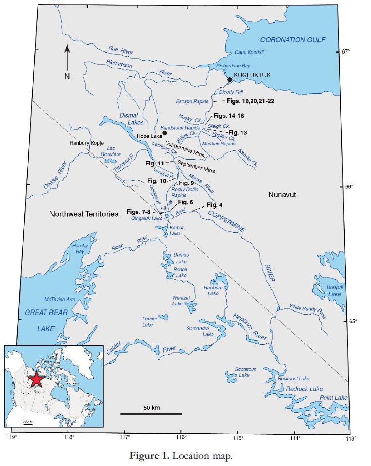
3 Meltwater from the ice sheet east of the valley carried enormous quantities of sediment into Glacial Lake Coppermine. Well exposed sedimentary sequences make it possible to document the history of this lake from its inception to its eventual drainage into Coronation Gulf. Five summers of systematic mapping (St-Onge 1988) provided the data required to reconstruct the complex history of this lake, which extended from Point Lake to Rocky Defile Rapids (Fig. 1) and, based on sedimentary facies, to propose a general model of the deglacial history of the Coppermine River region.
4 The bedrock south of Big Bend (Fig. 1) is part of the Wopmay Orogen (Hoffman 1984) composed of five tectonic zones which include a great variety of metamorphic rocks and granite bodies. North of Big Bend, northward-dipping Precambrian sedimentary rocks, mostly sandstone, are profusely intruded by Coronation Gabbro sills (Baragar and Donaldson 1973).
5 This paper is dedicated to Dr. Paul Hoffman who, in 1979, convinced me to go back to field work and map the Quaternary Geology sediments in the Coppermine River region.
MORPHOSEDIMENTARY ZONES
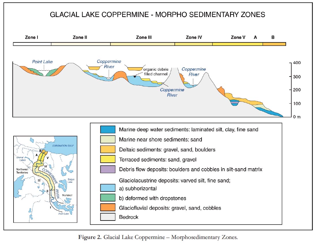
6 Along a transect, from Point Lake to Coronation Gulf, five major morphosedimentary zones are identified (Fig. 2). Each comprises several sedimentary facies reflecting environments of deposition, during deglaciation phases (Fig. 3).

Zone I: Point Lake – White Sandy River
7 Prior to glaciation, the Coppermine River valley was well established in the rolling upland underlain by rocks of the Canadian Shield between Point Lake and Coronation Gulf (Fig. 1). The Coppermine River valley is now mantled by a discontinuous blanket of glacial drift and is partly filled with glacial, glaciofluvial, glaciolacustrine and fluvial sediments (St-Onge 1984).
8 Ice originating from a dispersal centre to the east was responsible for the emplacement of the thick till in the Scotstoun Lake region (Fig. 3). The melting of this ice mass produced enormous amounts of water concentrated in subglacial, englacial and paraglacial conduits, which entrained large amounts of debris that were deposited as gravel and sand sediment bodies. In places, powerful meltwater streams also removed all, but the largest boulders, in their path. Thus, corridors were created in which sections of bedrock alternate with ice-contact features, such as esker ridges, transverse and circular ridges of glaciofluvial gravel and minor morainic ridges (Fig. 3). The concentration of very coarse material at fairly regular intervals along eskers that are, in places, continuous for several tens of kilometres, suggests they were constructed as successive, comparatively short segments (St-Onge 1984).
9 Deltas of coarse gravel and sand (Fig. 4) were constructed on both sides of the river valley, but are more common on the eastern side. The higher perched deltas lay at approximately 370 to 365 m asl (Fig. 5), indicating that they are associated with the similarly elevated oldest documented outlet of Glacial Lake Coppermine, through Kamut Lake (Fig. 1; St-Onge et al. 1981).
 Display large image of Figure 4
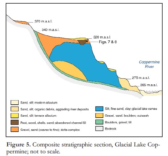 Display large image of Figure 5
10 South of Rocknest Lake, numerous lakes and streams are fringed by silty clay rhythmite layers, up to 6 m thick; these layers contain numerous small stones and boulders and are intensely deformed. Fresh exposures of the lower unit are more deformed than the upper unit, indicating that the deformation is, in part, syndepositional and probably resulted from the gradual melting of buried glacier ice. These rhythmites were likely deposited in water bodies confined to low areas between bedrock or till slopes, and large blocks of dead ice. Boulders melting out from the margin of the ice dropped onto the rhythmite deposits. Final melting of the glacier ice triggered extensive collapse and deformation within the sediments. These deformed rhythmite layers indicate that at some stage, the headwaters of the Kamut Outlet phase of Glacial Lake Coppermine were in stagnant ice from the disintegrating ice mass in the Scotstoun Lake area (Fig. 1; St-Onge 1984).
11 From 32 m above the present level of the Coppermine River, extensive sand terraces mark stages in down-cutting (Fig. 5; St-Onge et al. 1981).
Zone II: White Sandy River to Big Bend
12 Between the White Sandy River in the south and the Big Bend in the north (Fig. 1), and to the east and north of the Coppermine River valley, thick deposits of glacial drift are found in the Mouse River Graben between the Coppermine River and the headwaters of the Mouse River (Fig. 2). Glacioflu-vial sand and gravel are locally abundant and occur typically as esker ridges flanked by terraces up to one kilometre wide. Ridges generally trend southeast to northwest.
13 Within the Coppermine River valley are abundant exposures of coarsening-upward sequences of glaciolacustrine sediments ranging from deep water sandy silt rhythmites, through shallow water sand bodies to deltas of coarse sand and gravel (Fig. 5). In places, glaciofluvial sand and gravel protrude above the lacustrine sediments, indicating that in the very early stages of deglaciation, meltwater was flowing in ice tunnels at the base of the present valley.
14 Deltas (Figs. 4 and 5) with well-preserved braided channels on their surface are located in the valleys of numerous tributaries on either side of the Coppermine River valley. The altitudes are consistently between 360 and 370 m asl. Deltas on the east and north side of the valley are composed of coarser gravel than those on the south and west side, which tend to be sandier. While the deltas to the west and south were constructed by meltwater from a disintegrating residual ice mass, the eastern and northern deltas were constructed by more powerful streams originating from a proximal, and still active, ice front to the east.
15 It has not been possible to determine if the absence of deltas between 330 and 370 m (Fig. 5) was originally infilled in part, or not at all: in other words it has not been possible to determine how much, if any, of the rhythmite layers were removed in the early phase of downcutting by the river.
16 Silty sand rhythmite units (Fig. 5) are exposed in numerous sections; their buff-white colour makes them highly visible both on air photographs and in the field. The ‘summer’ layers, composed of sandy silt, vary in thick-ness from 1 to 50 cm, the thinner ‘winter’ layers of silty clay rarely exceed 2 cm. Counting indicate that in excess of 500 individual doublets are exposed in the thicker sections.
17 A crossbedded sandy unit, typically between 2 and 3 m thick (Fig. 5), is deposited on top of the rhythmite sequence. This remnant of an alluvial sand plain is commonly associated with coarse-grained, valley-side deltas and marks the minimum level of infilling of the Coppermine River valley up to the level of 320 m asl, 50 to 70 m above present valley floor.
18 During the downcutting phase of the ancestral Coppermine River numerous terraces were formed. The oldest preserved are at levels of 32, 25 and 20 m above present river level (Fig. 5). All these are erosional terraces carved into the rhythmite layers. They represent downcutting between the Kamut outlet phase at 370 m asl and the Dismal Lakes outlet phase at 285 m asl (Fig. 3). A lower terrace between 12 and 14 m above present river level is the result of aggradation (Fig. 5). A log found in this unit was dated at 4370 ± 60 14C years BP (GSC-3135); the cause for the aggradation and later erosion has not been determined but could be due to partial blocking of the river by a landslide farther downstream.
Zone III: Big Bend to Rocky Defile Rapids Section
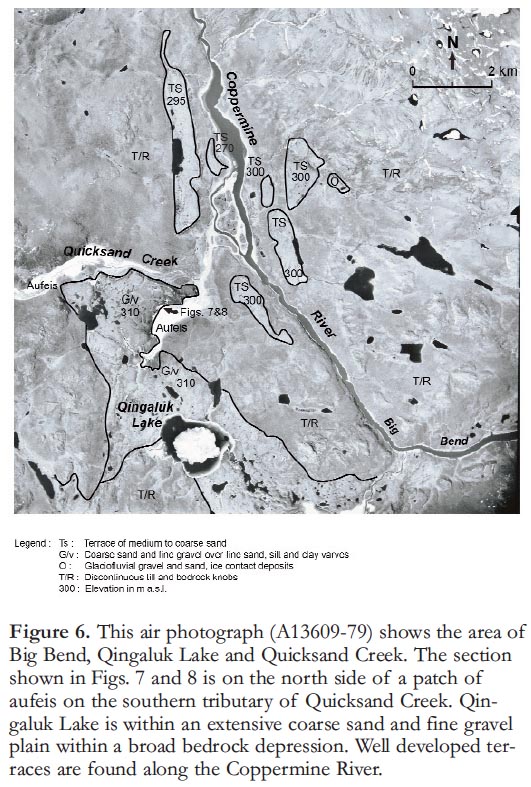
19 To the west of the Coppermine River valley between Big Bend and Kendall River, a 600-m high plateau of moderate relief is breached by two broad valleys draining east into the Coppermine River valley: the Quicksand Creek and Qingaluk Lake valleys (Fig. 1) in which are concentrated thick accumulations of glacial drift (Figs. 2 and 6). A narrow morainic ridge crosses the plateau between these two valleys (Fig. 3). West of the ridge a large body of glacioflu-vial sand and gravel occupies the trough of Qingaluk Lake valley. This sedimentary unit was emplaced by west-flowing meltwater streams running from an ice mass with a frontal position marked by the morainic ridge. Minor recession of the ice front allowed the drainage to change from west to south and finally to its present easterly course into the Coppermine River (St-Onge and Geurts 1982).
 Display large image of Figure 6
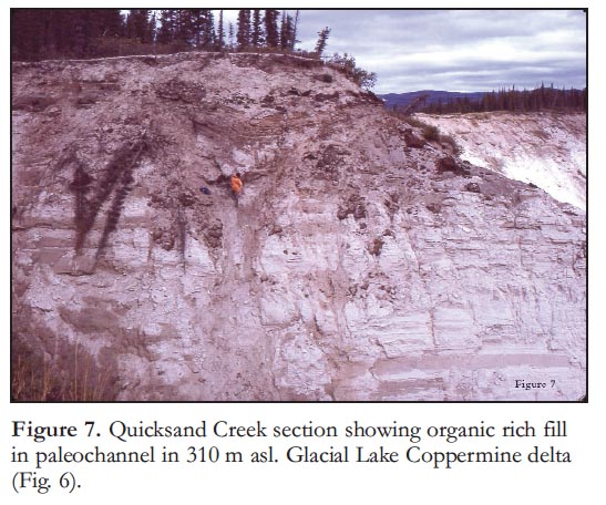 Display large image of Figure 7
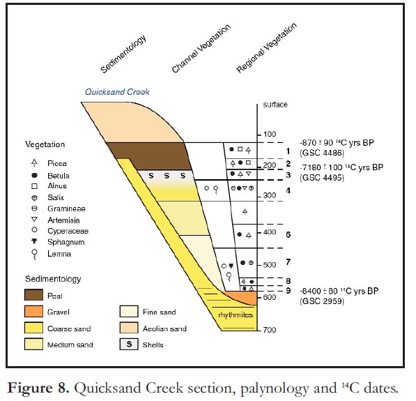
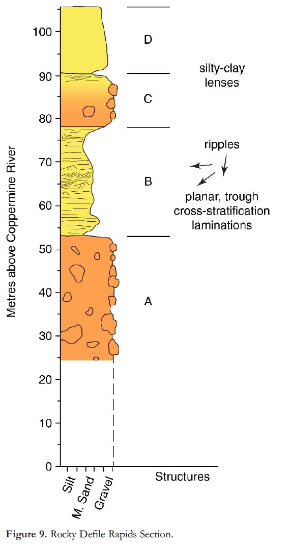
20 Qingaluk Lake occupies a depression in a large sand plain that partly fills a broad arc-shaped depression in the bedrock plateau west of the Coppermine River valley (Fig. 6). The depression probably represents a former course of the ancestral Copper-mine River valley which was earlier abandoned. As is the case for the valley upstream of Big Bend, the sandy silt rhythmite of the Qingaluk Lake valley resulted from infilling up to 320 m asl by Glacial Lake Coppermine sediment. This sand plain has a surface elevation of 300–320 m asl and is underlain by a thick sequence of sandy silt rhythmites. This sequence is well exposed (Fig. 7) on the northwest side of a small southerly branch of Quicksand Creek (St-Onge 1980). A former channel carved in the sand unit was later filled with organic debris (Fig. 8). A piece of wood at the base of this sequence has yielded a date of 8400 ± 80 14C years BP (GSC–2959), whereas a ~90 cm layer of peat at the top of the fill sequence has yielded two dates; the basal layer is 7180 ± 100 14C years BP (GSC-4495) and the top of the peat is 870 ± 90 14C years BP (GSC-4486). These dates indicate that the initial infill of the channel with sand and organic debris was completed in about 1200 years followed by over 6000 years of peat accumulation in a marshy environment. Detailed study of the organic material in this channel indicates a number of climatic fluctuations inferred from variations in pollen assemblages (Fig. 8). Within the Coppermine River valley, broad terraces are found on either side of the river at 300 m asl and mark a phase in the down-cutting by the river. Like terraces at similar altitudes upstream, they are related to the outlet of Dismal Lakes, which is at approximately 285 m asl (Fig. 3).The Rocky Defile Rapids (Fig. 1) were first described by John Richardson (Franklin 1823, p.153). An abandoned section of the Coppermine River valley is filled, in part, by a 110-m thick deposit of coarse sand, boulders and gravel (Fig. 9). Basal unit A is a massive structureless, high sand content diamicton. Grain size ranges from a silty sand matrix to boulders over 1 m in diameter. Large clasts tend to be well rounded and lithologically diverse. The upper contact with unit B is quite abrupt. The base of 25-m thick unit B consists of 0.5 m of massive silty sand grading into a laminated sand and silty sand layer 2 to 10 cm thick. Scattered coarse-sand beds containing rare pebbles near the base are overlain by poorly defined ripple sets. Large trough crossbeds have a 050° current direction. Laminated sand beds are truncated by trough crossbeds that dip 25° to the west. Ripples and planar cross-stratification indicate paleocurrent directions of 255 to 265°. Near the top of unit B, sand grades into sandy silt and occasional clay layers, up to 5-cm thick, which appear convoluted. Laminated silt beds are also found near the top of unit B (Fig. 9). Unit C is a sand matrix diamicton having clasts up to 1 m in diameter that overlies unit B. This 12-m thick unit, grades upward into a coarse sand which, in turn, is overlain by silty clay lenses intercalated with a 50-cm thick medium sand bed (Unit D).The uppermost unit, exposed at Rocky Defile section, is a 15-m thick, massive, gravelly sand and cobbles up to 30 cm in diameter; coarse sand and granules predominate.
21 This sequence is interpreted as an ice-contact complex deposited by a stream flowing west-southwest from glacier ice into Glacial Lake Copper-mine; it is here that northward drainage was dammed during the 365-m high level (Kamut Lake outlet phase) of Glacial Lake Coppermine (Ice front 2, Fig.3). To the north of this ridge, a channel that cuts across a bedrock spur connects the Copper-mine River valley with the Kendall River valley. This abandoned channel has a sill elevation of 300 m.
Zone IV: Rocky Defile Rapids to Melville Creek Section
22 North of Rocky Defile Rapids (Figs. 1 and 3), the Coppermine River crosses a broad NW–SE bedrock depression bounded on the south by the rolling upland of the Big Bend region (600–800 m asl) and to the north by the Coppermine and September mountains (400–600 m asl). The Dismal Lakes occupy the northwestern part of the bedrock depression and drain to the Coppermine River valley by the rocky and turbulent Kendall River. The Mouse River occupies the depression to the southeast and drains a large number of lakes.
 Display large image of Figure 10
23 In the Dismal Lakes–Kendall River depression, a drumlin field with individual drumlins up to 2000 m long and trending between 335 and 310o indicate that the last active ice flowed toward the northwest. Adjacent to these drumlin field sequences of nested lateral moraines, valley-side kame terraces and ice-contact deltaic land-forms suggest that the downwasting of a remnant ice mass in the valleys took place.
24 During deglaciation, the two distinct depressions now occupied by Dismal Lakes were buried under a stagnant ice mass. Fluvioglacial and debris-flow processes emplaced numerous kame and minor morainic ridges on both sides of the valley with steeper ice-contact slopes towards the basins. When the northwest basin became ice free, a large kame delta was deposited. At 285 m asl, this channelled flat-top deposit now stands 30 m above present lake level and separates the ‘two’ Dismal Lakes. This terrain marks the water level of a lake which drained through the now abandoned spillway at the northwestern end of the Dismal Lakes, at 285 m asl into a glacial lake farther west (St-Onge and Dredge 1985).
25 The basin east of the Copper-mine River now drained by Mouse River contains a varied suite of sediments reflecting a somewhat complex history of deglaciation (Fig. 10). A sequence of channels, deltas, and partly collapsed kames was likely formed at the margin of an ice mass which occupied the Mouse River lowlands. As the highlands to the south became ice-free, water flowed towards the lower ground and deposited sediments in a narrow embayment at the margin of the ice. In time, an ice-marginal lake was formed into which deltas were built. The disappearance of the ice resulted in the collapse of the kames and in the deltas being perched at 300 m asl on the south side of the basin (Fig. 10 Dg).
26 By the time glacier ice had nearly completely disappeared from the area, a lake still occupied part of the Kendall River–Mouse River basins, which was dammed by glacial ice in the valley north of September Mountains (Ice front 3, Fig. 3). At least 17 m of rhythmically bedded sandy silt and clay were deposited in this lake which was the last remnant of Glacial Lake Coppermine (Fig. 3). The bedded silt grades upward into coarse sand and planar beds, gently dipping at 330°. Large crossbeds and ripple trough crossbeds indicate a high-energy environment established during Dismal Lakes’ outlet phase of Glacial Lake Coppermine. The lake level was maintained by glacial ice which damned the narrow Coppermine River valley to the north of Larrigan Creek. At this site (Fig. 3) an outwash delta built into the lake now forms terraces culminating at approximately 300 m asl.
27 The river eventually removed most of the coarsening upward sequence emplaced in the Mouse River basin. The remnants now stand as terraces 50 m above river level. In the area that was incised by the Copper-mine River, an elongated fan-shaped body of coarse gravel was deposited. This channelled surface now forms a 15-m high terrace on the east side of the river (Fig. 10, Tg 225).
 Display large image of Figure 12
28 North of the Dismal Lakes and the Kendall and Mouse River basins, the Coppermine River enters a narrow, steep-sided bedrock valley that cuts through the high ridges of Coppermine and September mountains. Erratics are strewn over bedrock uplands. Terraces on either side of the river are covered with generally unmodified ice-contact sediments and landforms including esker ridges.
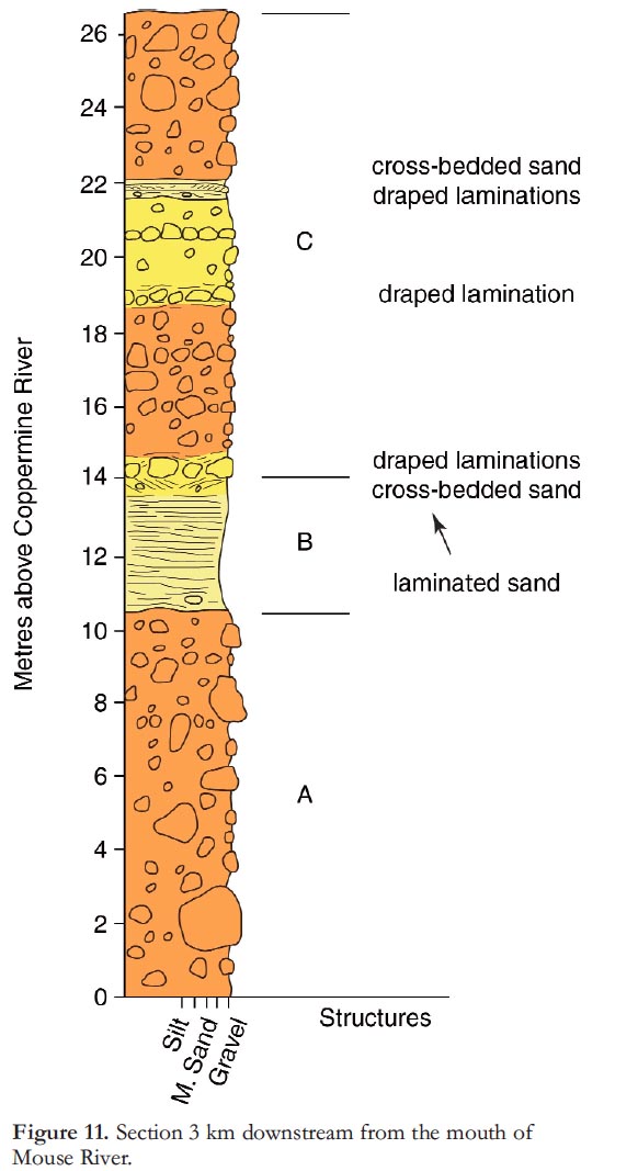
29 The 27-m high section on the north side of the Coppermine River (Fig. 11) has two poorly stratified sandy diamictons containing clasts up to 1.5 m in diameter. Boulders are generally well rounded and of varied lithology; a well-stratified coarse sand unit separates the two diamictons. Lower unit A is a 10.25 m thick diamicton, composed of a sand matrix supporting clasts ranging in size from pebbles to boulders over 1 m in diameter. Boulder–cobble concentrations identify poorly defined beds 1 to 2 m thick and having a slight dip to the NW. Unit B is a 3.75 m thick layer of coarse sand. Laminated fine to medium sand with lenses of coarse sand form an abrupt lower contact. The sequence coarsens upward to pebbly sand with gravel and cobbles. The upper part of the unit is marked by planar cross-stratification; interbedded sandy silt and pebbly sand layers dip at 15° toward 340°. The upper contact at the base of a boulder lag is a pebbly sand matrix with ripples. A boulder and cobble concentration forms the abrupt basal contact of unit C, which is 13-m thick composed of a series of sandy diamicton layers 1 to 4 m thick, separated by cobbly lags, in place overlain by draped laminations. These poorly sorted sediments are interpreted as a debris flow complex resulting from rapid downcutting by the Coppermine River, following the disintegration of glacier ice north of September and Coppermine mountains. The relationship of this diamicton to the Sleigh Creek Formation (below) is not known.
Zone V: Melville Creek to Coronation Gulf Section
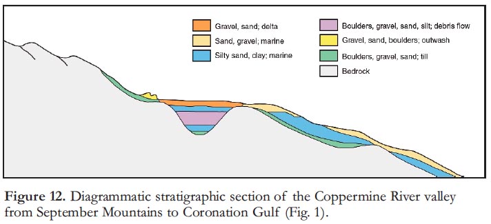
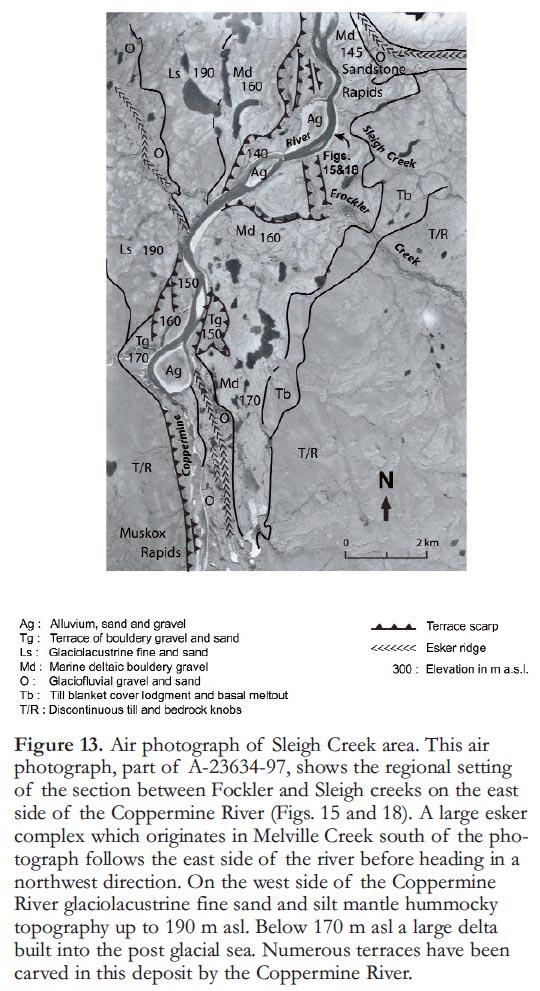
30 The Melville Creek to Coronation Gulf section (Figs. 1 and 2) contains a complex sedimentary sequence which yields an abundance of information on the postglacial history of this part of the river valley (Fig. 12). The valley of Melville Creek is partly filled with glaciofluvial sand and gravel including a large multi-crested esker complex and numerous terraces. The esker follows the east side of the Coppermine River Valley as far downstream as Willow Creek (Fig. 1) where, after a short gap, it continues on the west side of the valley. Just above Willow Creek, both sides of the esker complex are flanked by a flat gravel surface scarred by numerous abandoned channels and a few lakes (Fig. 13, Ls 190). The large delta at 160 to170 m asl on the east side of the Coppermine River (Fig. 13) is the highest of a series constructed into the postglacial sea (St-Onge and Bruneau 1982).
31 Sediment sequences logged in paleo-bedrock valleys (Fig. 14) and exposed in numerous sections along the modern Coppermine River valley have made it possible to establish a lithostratigraphic diagram extending from Muskox Rapids to Coronation Gulf (Fig. 12). This represents an offlap marine sediment sequence coarsening upward from fine sand–silt–clay rhythmite deposits to bouldery gravel deltas. A 30-m thick diamicton complex is located in the middle of these marine sediments and was named the Sleigh Creek Formation by St-Onge and Lajoie (1986).
 Display large image of Figure 13
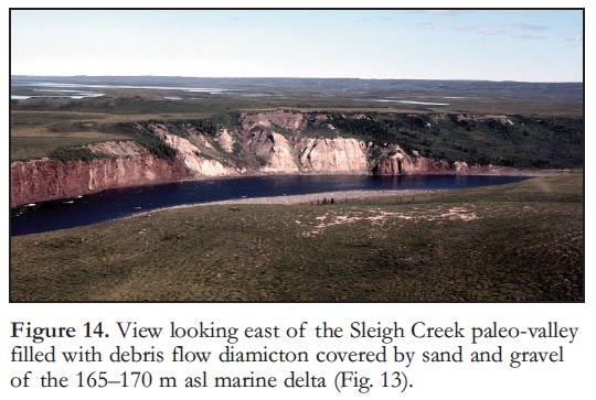 Display large image of Figure 14
32 The Sleigh Creek Formation (Figs. 13 to 18) is bracketed by sequences of very fine sand, silt and clay in horizontal beds 5 to 50 cm thick that have sharp upper and lower contacts, and are normally graded. In at least two 2-m horizons, the beds have been intensely contorted by sub-aqueous mass flow events. The lower and upper rhythmite sequences have variable thicknesses; the lower rhythmite sequence is up to 14 m thick (Fig. 12; Bruneau 1985), whereas the upper sequence has a maximum exposed thickness of 3 m.
 Display large image of Figure 15
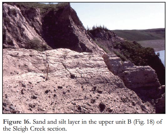 Display large image of Figure 16
 Display large image of Figure 17
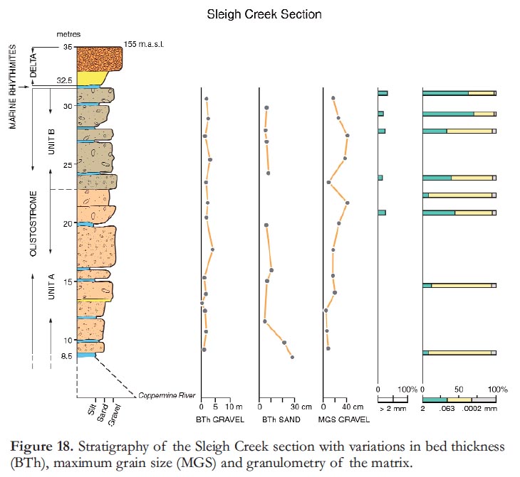 Display large image of Figure 18
33 Sections 1.5 to 2 km upstream of Bloody Fall (Figs. 1 and 12) show up to 70 m of rhythmites on boulder-covered bedrock. In these sections, the diamicton sequence is not present suggesting that it forms a northward-thin-ning wedge and that the flows responsible for their transportation did not reach this far north. Marine shells have been found in the upper rhythmite sequence, below 110 m asl, and also in the sand layers overlying it. The rhythmite sequences form a package that extends to the present sea coast and, presumably, below Coronation Gulf. The sedimentary characteristics and the presence of marine shells near the top of the stratigraphic column strongly suggest that the sediments of the rhythmite sequences were emplaced by turbidity currents in a marine basin (Lajoie and St-Onge 1985).
34 The sections described below include all of the units and sedimentary characteristics of the Sleigh Creek Formation. Several other sections along the Lower Coppermine River also show one or more of the units described.
35 The Sleigh Creek section (Figs. 13 to 18) extends for 1.5 km on the east side of the Coppermine River just upstream from the mouth of Sleigh Creek (Fig. 13). The bedrock walls of the buried channel are well exposed at both ends of the section. Erosion by the Coppermine River along the entire length of the section has provided excellent exposures of the channel fill. Total thickness of the section is 45 m. The lowermost 8.5 m is largely talus although bedrock is sporadically exposed. Two exposed diamicton units have a minimum thickness of 23 m. The upper 13.5 m is coarse sand and the bouldery talus of the uppermost delta built into the postglacial sea (St-Onge and Bruneau 1982). At the south end of the section, fine sand and silt rhythmite layers are draped over the few large clasts protruding from the uppermost diamicton bed.
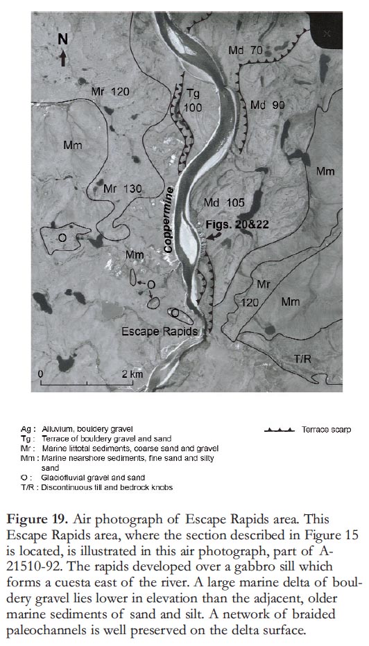
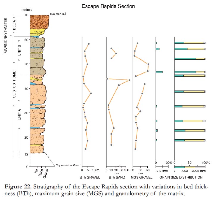
36 The Escape Rapids section (Figs. 19 to 22) extends for over 500 m on the east side of the valley. Roughly 70 m of channel fill are exposed and consist of two diamicton units having a combined thickness of 50 m. This sequence is overlain by 10 m of coarse sand and bouldery gravel, part of a postglacial marine delta. In a gully at the north end of the section, thick silt and fine-sand rhythmite deposits are exposed at the same level as the diamictons. Individual beds are up to 1.5 m thick suggesting that these are proximal turbidites. Small fragments of marine shells were found, but none in life position. In the same part of the section, a poorly exposed unit of sandy silt rhythmite occurs between the diamicton sequence and the overlying deltaic sediments.
 Display large image of Figure 19
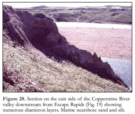 Display large image of Figure 20
 Display large image of Figure 21
The Diamicton Sequence
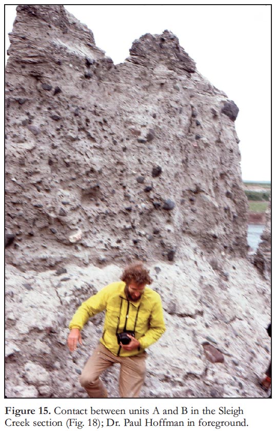
37 In both sections studied the diamicton sequence is composed of a lower Unit A and an upper Unit B (Figs. 18 and 22). Colour distinguishes the diamicton units; Unit A is light buff whereas Unit B is a light brown. In both sections, the matrix of Unit A in the diamicton is siltier (30% sand, 65% silt, 5% clay) than Unit B (55% sand, 40% silt, 5% clay). On average, clast size is smaller in Unit A than in Unit B. Clasts are less abundant in Unit A averaging 25 to 30%; in Unit B they make up to 50% of the deposit.
 Display large image of Figure 22
38 In the Escape Rapids section (Figs. 20, 21 and 22) a 4-m thick band of interfingering silty sand lenses and irregular thin beds of diamicton mark the upper limit of Unit A. In the Sleigh Creek section (Figs. 16 and 18) the top of Unit A is a 2.8 m bed of gravel in a silty matrix; large clasts are rare.
39 Upper Unit B is a sequence of dark brown sandy diamicton beds. In the Escape Rapids section (Fig. 21), the basal bed of the unit is a bouldery diamicton with individual clasts up to 60 cm in diameter. The bed in the same stratigraphic position in Sleigh Creek section (Figs. 17 and 18) is a very pebbly diamicton with individual clasts seldom larger than 5 cm.
40 The diamicton beds range in thickness from 1 to 7 m. The basal contact with the underlying sediments is sharp and not obviously erosive; there is no sign of channelling within the two diamicton sequences. Beds are easily identified by the presence of thin interbeds of generally massive, but locally crossbedded, fine to very coarse sand; climbing ripples were seen at only one location. Within the diamicton sequences, the beds are generally massive; traction structures are absent, and reverse grading was observed in two beds. The large clasts commonly have long axes both parallel and perpendicular to bedding. The clasts in the diamicton range up to boulder size. They vary considerably in size both from bed to bed and laterally within individual beds. Well rounded cobbles and boulders make up variable proportions of the sediments.
41 To evaluate the provenance of the diamicton, clasts larger than 5 cm in diameter were systematically sampled along a vertical profile in the Sleigh Creek section. In the lower diamicton (Unit A), 58% of the sample has local provenance, the other clasts are derived from sources outside the Coppermine Homocline (Baragar and Donaldson 1973), mostly from the area of Wopmay Orogen to the south (Hoffman 1984). In the upper diamicton (Unit B), 56% of the sample is of local provenance, and the balance from other sources. As a whole, 40 to 45% of the fragments in the Sleigh Creek diamicton represent rock types that are not present in the Coppermine Homo-cline. In comparison, the study of fragment composition in the till suggests a much higher percentage of locally derived rock types.
42 The most striking difference between the diamicton of the Sleigh Creek Formation and the regional till is colour. The Sleigh Creek Formation is light buff to brown whereas the till matrix has a distinctly reddish tinge derived from red sandstone and shale. Other fundamental properties distinguish the channel fill from the till: a) the diamictons of the fill were deposited in distinct layers interbedded with sand and gravel, and b) the clasts, within the fill, average 40 to 50% of fartravelled erratic material. In contrast, although exposures of till are poor, the deposit appears massive with an erratic content of less than 25%. These data indicate that the diamicton sequence and the local till have distinct rock types and provenance.
Discussion
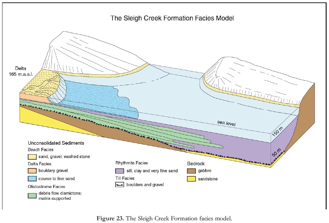
43 The model proposed for the accumulation of the Sleigh Creek Formation is summarized in Figure 23, which represents a section along the fill in a bedrock valley that cuts across a cuesta landscape. The coarse fraction of the Sleigh Creek Formation is matrix supported; the beds are massive or inversely graded, and have sharp nonerosive contacts and traction structures are absent. These characteristics suggest that the coarse fraction was deposited by a debris flow. In this type of deposit each bed results from a single flow event in which matrix strength is the main clast support mechanism. Lack of imbrication and grading in the Sleigh Creek diamicton indicates a lack of clast to clast movement during flow. The high degree of roundness of the gravels is an inherited feature from previous depositional cycles, and is characteristic of gravel and till in the Wisconsinan drift of the region.
44 The rhythmite sequences that underlie the diamicton are thought to have been emplaced by turbidity currents generated by the massive sediment flux at the outlet of the Copper-mine River. The overlying rhythmite sequences also accumulated from turbidity currents, but originated in deeper water at the front of the rapidly building bouldery delta at 165 m asl Since the diamicton sequence is deposited between marine rhythmite layers it is likely that deposition occurred in a subaqueous environment. The Sleigh Creek Formation is an exceptionally well exposed, early post-glacial olistostrome.
DEGLACIATION PHASES
45 The information required to construct a time-constrained model of ice retreat in the Coppermine River valley region, extending from Point Lake to Coronation Gulf, was gathered through systematic geological mapping in the area by the Geological Survey of Canada between 1979 and 1984 and, from 1985 to 1989, for regions to the north and northwest. From the distribution of sediments (described in the first part of this paper) it is now possible to propose a general model of Late Wisconsinan ice retreat. The four ice front phases described are not defined by continuous ice-contact deposits. Mostly, the margins are surmised from the configuration of glacial lakes in the Coppermine, Kendall and Richardson river valleys, and are based on the reasoning that lake levels determined from sedimentary deposits require that regions lying below those levels were occupied by glacier ice. Also, both location and elevation of deltas, built in glacial lakes, can be used to discern ice-front positions. Another criterion is side-hill or lateral channels and kames, which could only have been formed by a stream confined on one side by glacier ice.
46 The ice fronts define significant events in the course of ice retreat to which a tentative age can be assigned, in large part due to a major synthesis of deglaciation of central and northern Canada by Dyke (2004).
Model of Ice Retreat
Phase 1: Forcier Lake Moraine
47 The most westerly of the former ice-front positions determined in this study were established during the Forcier Lake Moraine phase (Fig. 3). The Forcier Lake Moraine is located approximately halfway between McTavish Arm of Great Bear Lake and the Coppermine River and is described by St-Onge et al. (1981). This moraine is a single 5 to 20 m high ridge that extends northward for nearly 60 km. It is composed of boulders, up to 3 m in diameter, in a sand-gravel matrix. West flowing meltwater breached the ridge and deposited small sand and gravel outwash fans; these are covered by string bogs in many places. Its eastern slope is generally steeper than the west; this, along with fans on the west side, indicates the Forcier Lake Moraine was constructed by west-flowing ice. According to Dyke (2004), the Forcier Lake Moraine is correlative with a late phase of the Bluenose Lake Moraine (St-Onge and McMartin 1995) and would be part of the 10.25 14C ka BP phase (Dyke 2004). This would place the Forcier Lake Moraine Phase within the Younger Dryas Chronozone (11–10 ka BP). The Dismal Lakes basin was completely occupied by ice at this time and melt-water eroded a 4 km long and 30 to 50 m deep channel at the western end of the lake basin. A large sand plain was deposited west of Dismal Lakes and north of Dease River (St-Onge and Dredge 1985).
48 The ice front flowed around a 550-m high plateau north of the western part of Dismal Lakes. Ice-marginal lakes formed between this plateau and the ice lobe in the basin of Richardson and Rae rivers. Numerous kames and deltas at approximately 270 m asl with collapse structures to the north mark this frontal zone.
Phase 2: Glacial Lake Coppermine
49 During ice retreat between deglaciation phases 1 and 2 (Fig. 3), the Copper-mine River valley from Rocknest Lake to 10 km south of the Kendall River was ice-free and was occupied by Glacial Lake Coppermine. The outlet of the lake was at 365 m asl through Kamut Lake and Sloan River (St-Onge et al. 1981). Near Rocky Defile Rapids, the former ice front is marked by a massive deposit of sand, gravel and boulders filling a pre-glacial section of the Coppermine River Valley (Fig. 9).
50 In the Scotstoun Lake region, meltwater eroded 30 to 40 m deep, box section gorges in slate that underlies the divide between Rocknest Lake and the Hepburn and Coppermine rivers. At the downstream ends of these canyons, coarse sand and gravel deltas were built at 365 m as1 into Glacial Lake Coppermine. This elevation clearly indicates that the melting of the Scotstoun Lake ice, the carving of the rock canyons and the construction of the deltas were synchronous with the Kamut outlet phase of Glacial Lake Coppermine (St-Onge and Guay 1982).
51 North of Rocknest Lake, the ice front was located at the headwaters of White Sandy River (Fig. 3). Rhythmite deposits and sand terraces are part of the Glacial Lake Coppermine suite of sediments and indicate that the river valley was ice-free and well nourished with medium- and fine-grained sediment.
52 North of the point where the White Sandy River flows into the Coppermine River, numerous perched gravel deltas are found east and north of the Coppermine River valley. Because the deltas are large and consist of coarse bouldery gravel, their construction required a high energy flow that could only have come from melt-water streams from glacier lying no farther away than the present divide, an average distance of less than 15 km.
53 An ice tongue occupied the southeastern part of the Dismal Lakes basin. Here, a moraine of bouldery till was deposited across the valley of the Dismal Lakes on the distal side of which, a thick apron of coarse out-wash gravel was deposited in a lake. The altitude of the outlet was controlled by the sill elevation at 285 m asl of the channel cut at the western end of the lake during Phase I. This deglaciation phase is correlative with the 10 400–10 200 years BP Central Wollaston Peninsula phase (Dyke et al. 2003). Glacial Lake Coppermine is thus a major feature of the late Younger Dryas Chronozone.
Phase 3: Mouse and Richardson Rivers
54 In the Kendall River–Dismal Lakes valley, a retreat of 1 to 5 km from ice position 2 opened a channel just north of Rocky Defile Rapids at 300 m asl (Fig. 3). When this occurred, the Kamut Lake outlet was abandoned, and Glacial Lake Coppermine drained northwest, through this new, lower outlet. Following this, drainage may have been through the 285 m asl channel at the western extremity of Dismal Lakes, as was previously assumed (St-Onge 1980; St-Onge et al. 1981) or it could have been across a saddle north of Dismal Lakes at 275 m asl, allowing Glacial Lake Coppermine to drain into the Richardson River basin. There is no well defined channel in the narrow wind gap found there to substantiate this, but this may be because the drainage was partly across dead ice, or because active scree accretion has buried the channel.
55 Along the western tributary of the river north of Hope Lake, a series of stepped deltas of bouldery gravel testify to the rapid lowering of ice marginal lake levels as a consequence of the rapid shrinking of the Richardson–Rae rivers ice lobe (St-Onge and McMartin 1995; Dyke et al. 2003).
Phase 4: Postglacial Sea
56 During Phase 4 (Fig. 3) the ice in Coronation Gulf thinned rapidly as a result of calving into the Arctic Ocean to the northwest. West of Coronation Gulf, retreat of the ice front allowed the glacial lakes to drain by a series of side-hill channels.
57 The disintegration of the ice in Coronation Gulf and in the lowlands to the south resulted in marine inundation of the isostatically depressed lowlands to a present elevation of 170 m asl (St-Onge and Bruneau 1982). Within the Copper-mine River valley a large bouldery delta at 165 m asl (Figs. 13 and 23) marks this limit as do numerous other deltas east of the Coppermine River and south of Coronation Gulf. All deltas show ice-contact features proximally indicating that dead ice was still present at this stage. This marine transgression marks the termination of the Late Wisconsinan glaciation in the Copper-mine River valley and the beginning of the emplacement of an offlap sedimentary sequence between Muskox Rapids and Coronation Gulf (Fig. 12).
DATING
58 The events discussed are rarely dated directly and generally only minimum ages can be assigned. Table 1 in St-Onge and McMartin (1995), lists the significant radiometric dates along Dolphin and Union Strait to the northwest of Coronation Gulf (Fig. 1). In the Coronation Gulf area (Fig. 1) dates range from 9 880 ±90 to 10 530 ±260 14C years BP (St-Onge 1987). However Dyke (2004) argued for the exclusion of dates based on deposit-feeding marine molluscs from calcareous sediment as being too old. Furthermore, England et al. (2012) demonstrated that, “The age discrepancy between suspension and deposit feeders in calcareous terrain is non-systematic in space and time thereby invalidating the application of a correction.” Therefore, given that many of the earlier dates can no longer be considered reliable, indicators of the time when Coronation Gulf (Figs. 1 and 3) was freed from glacial ice, must be based on the deglaciation reconstruction by Dyke (2004), in which Coronation Gulf is shown as becoming ice-free between 10 000 and 9 600 14C BP. However, for the lake to exist, glacier ice must have blocked the valley north of Rocky Defile where the top of the paleo-valley infill is at 310 m asl (Fig. 9). This implies that a substantial amount of glacier ice existed north and northwest in the Richardson River basin and in Coronation Gulf (Phase 2, Fig. 3) and an ice front was continuous with the Central Wollaston Peninsula phase (Dyke et al. 2002) dated at 10.2 ±0.1 – 10.4 ±0.1 ka. Glacial Lake Coppermine is estimated to have lasted a minimum of 450 years (St-Onge et al. 1981) and was a significant feature in the deglaciation landscape during the late Younger Dryas Chronozone. This interpretation requires that the 10.25 14C ka BP paleogeographic map (Dyke 2004) be modified so that the Coppermine River Valley was ice free at this time.
59 A calcareous concretion washed out from the base of the varve sequence of Glacial Lake Coppermine has yielded a 14C age of 14 400 ± 500 14C years BP (UQ-814). This is ca. 3 800 years older than the estimate for the Glacial Lake Coppermine above and appears old relative to all the generally accepted models of deglaciation (Dyke 2004).
SUMMARY AND CONCLUSIONS
60 The deglaciation model presented here explains the morphosedimentary units of late Quaternary age, in the Copper-mine River valley region, as a continuum from glacial to glaciolacustrine to marine environments.
61 The postglacial history clearly demonstrates that the transition period from a glacial to a nonglacial environment was a time of great environmental change involving multiple phases in the activity of geological processes. Meltwater was moving vast amounts of sediment that was deposited as out-wash complexes or in glaciolacustrine sequences.
62 When the ice receded from the Coronation Gulf region, glacial lakes drained and the sea inundated the depressed land. In incising through the glacial lake sediments, the Coppermine River mobilized enormous volumes of unconsolidated glacial lake sediment that occupied the preglacial valley. The resulting debris flows, rapidly filled a network of bedrock valleys that were then below sea level. Very large deltas, the highest of which are at 170 m asl, were built into the receding sea while tens of metres of silty rhythmites were being deposited in the deeper part of the paleobasin.
63 By comparison the present day geological processes in the Coppermine River valley region are subtle and the landscape is essentially quiescent. The roaring rapids, the picturesque falls, the minor landslides and the churning of surface material by frost action do not significantly modify landforms inherited from the brief and turbulent period of ice retreat.
Fieldwork for this project was made possible initially by a grant from the Rector’s fund, University of Ottawa. Later grants from Natural Sciences and Engineering Research Council, Energy, Mines and Resources (now NRCan), and Indian Affairs and Northern Development now AAND), allowed graduate students to become involved. Of the many individuals who helped the author and his students, Dr. Paul Hoffman is certainly the one I am most indebted to; he and his senior field assistant Dr. Marc St-Onge convinced me to go back to field work and map the Quaternary sediments in the Coppermine River region. One summer in the field with Paul’s group led me, in 1982, to leave academic life and go back to the tundra, thus the rest of my career was defined. Their sustained help with field logistics made possible the systematic mapping of the surficial deposits of the Coppermine River basin. Dr. Jean Lajoie, retired from the département de géologie, université de Montréal, provided essential expertise in the study of the Sleigh Creek Formation. Thanks are also due to Dr. W. Padgham, Chief Geologist, Department of Indian Affairs and Northern Development, Yellowknife, whose office provided grants to students, expert radio expediting during the field season and very much appreciated access to fixed wing aircraft. Pilots, mining camp managers and colleagues who helped in a variety of ways are assured of my deep gratitude. Comments by Marc St-Onge, Art Dyke and two anonymous reviewers which helped improve an earlier version of this paper are greatly appreciated. The figures were drafted by Tracy Barry and Kim Nguyen whose talents transformed sketches into art.