Series
Great Mining Camps of Canada 5.
Britannia Mines, British Columbia
SUMMARY
Britannia was discovered in 1888, began production in 1905, and after nearly 70 years of underground operation produced more copper than any other mine in British Columbia. At one time it was the largest copper mine in the British Empire. Britannia survived the Great Depression, labour shortages brought on by two world wars, and several natural disasters. For most of its life Britannia was owned by the Howe Sound Company of New York, which was formed in 1903 for the purpose of financing the development of the mine. In 1963 it was purchased by Anaconda Canada Limited, which operated the mine until closure in 1974.
The Britannia camp encompassed eight separate ore zones located approximately 5 km inland from Britannia Beach. The deposits occurred within a large shear zone in a roof pendant of Mesozoic sedimentary and volcanic rocks enclosed by the Coast Plutonic Complex. Until a few years before mining ceased, the deposits were believed to have been emplaced in structurally favourable sites by hydrothermal fluids; the most recent interpretation of the deposits invokes a VMS model.
During the mine’s lifetime, thousands of people worked at Britannia, and they and their families lived in one of two company towns that, until 1956, were accessible only by coastal steamer. After closure, the community of Britannia Beach faced the prospect of becoming a mining ghost town, and the distinction of being the site of an environmental hazard created by acid mine drainage. A solution to the pollution problem was found, and road access to Vancouver combined with the success of the Britannia Mine Museum, a highlight of which is the surviving and spectacular mine concentrator that has been designated a National Historic Site, have given Britannia Beach a promising future.
Britannia is historically important from a mining technology viewpoint because it was the first mine in BC to successfully employ froth flotation. It was economically significant because it was an important element in BC’s emerging economy and it is culturally significant because the Britannia communities represented a way of life that was typical of many Canadian mining towns in the first half of the 20 th century. Moreover, Britannia Beach has survived and has become a well established community. Additionally, the recent history of Britannia Beach illustrates the importance of environmental considerations related to mine closure.
SOMMAIRE
La mine Britannia a été découverte en 1888, elle a débuté sa production en 1905 et, en près de 70 ans d'exploitation souterraine elle a produit plus de cuivre que toute autre mine en Colombie-Britannique. À une époque c’était la plus grande mine de cuivre de l'Empire britannique. Britannia a survécu à la Grande Dépression, aux pénuries de main-d’œuvre provoquée par les deux guerres mondiales, ainsi qu’à plusieurs catastrophes naturelles. Pour la majeure partie de son existence, Britannia a été la propriété de la société Howe Sound de New York, laquelle a été formée en 1903 dans le but de financer la mise en valeur de la mine. En 1963, elle a été achetée par Anaconda Canada Limited, laquelle a exploité la mine jusqu'à sa fermeture en 1974.
Situé à environ 5 km de la côte de Britannia Beach, le camp minier de la Britannia était constitué de 8 zones minéralisées distinctes. Les gisements étaient situés dans une grande zone de cisaillement située dans le toit d’une unité de roches volcano-sédimentaires mésozoïques du Coast Plutonic Complex. Quelques années avant la fin de l’exploitation, on croyait encore que les gisements avaient été mis en place par la migration de fluides hydrothermaux dans des pièges structuraux favorables, mais l'interprétation la plus récente suggère plutôt une mise en place selon le modèle des SMV.
Tout au long de son exploitation, des milliers de personnes ont travaillé à la mine Britannia et ces travailleurs et leurs familles demeuraient dans l’une des deux villes de compagnie; notons que l’endroit n’était accessible que par un vapeur côtier jusqu’en 1956. Après la fermeture de la mine, la ville de Britannia Beach a bien failli devenir une ville fantôme avec la réputation de constituer une menace pour l’environnement étant donné les effets du drainage acide des résidus miniers. Mais grâce à la solution qui a été appliquée, à la route qui a été construite jusqu’à Vancouver et au succès du musée de la mine Britannia avec son spectaculaire concentrateur, lequel a pu être préservé et qui a été désigné lieu historique national, Britannia Beach peut maintenant être confiante en l’avenir.
Du point de vue technologie minière, la mine de Britannia est importante historiquement en ce qu’elle fut la première mine de C.-B. qui ait employé avec succès le procédé de séparation de flottation par mousse. Économiquement elle fut un élément majeur de l’économie émergente de la C.-B. Les communautés de la Britannia sont importante culturellement aussi en ce qu’elles représentent un mode de vie typique des villes minières canadiennes de la première moitié du 20e siècle. Qui plus est, la ville de Britannia Beach a subsisté au-delà de son épisode minier et est devenue une communauté autonome. L’histoire récente de Britannia Beach montre bien qu’il est important de tenir compte des questions environnemen-tales liées à la fermeture d’une mine.
INTRODUCTION
Location, Access and Historical Background
1 Britannia Beach and the mine sites lie 40 km north of Vancouver, British Columbia (BC), on the eastern side of Howe Sound, a fiord-like inlet set in rugged, heavily timbered mountainous terrain (Fig. 1). Britannia Beach, on the shore of Howe Sound, was the administration centre and the location of the concentrators. Today, the Sea-to-Sky highway and a branch line of the Canadian National Railway run from Vancouver, through Britannia, Squamish and Whistler to the interior of BC. The highway forms the backbone of a growing residential and recreational corridor that offers a variety of water and alpine activities set in spectacular scenery. However, during the period from 1888 to 1904, when Britannia was discovered and developed, Howe Sound was remote and sparsely populated.
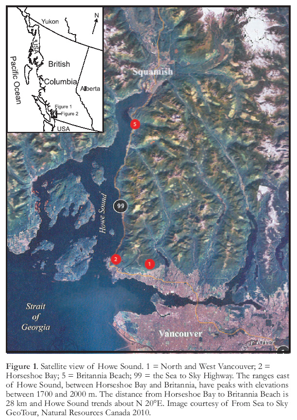 Display large image of Figure 1
2 In the late 1880s, settlers who began farming in the Squamish Valley, at the head of Howe Sound (Fig. 1), sent their crops to the Vancouver market by ship. By 1891 the Union Steamship Company, which serviced isolated logging camps, salmon canneries and farms along the BC coast, had established a twice weekly service to the community of Squamish, 10 km north of Britannia, but at that time there was no road connection between Squamish and Britannia. The population of Vancouver in 1900 was only about 12 000. It was not until 1956 and 1957 that rail and road, respectively, connected Britannia to the ‘outside’, thereby severing the dependency of the isolated and close knit Britannia communities on the Union Steamship Company.
3 Britannia was discovered and developed early in the history of mining and economic growth in BC. The Fraser River and Cariboo gold rushes (1858 – 1863), the discovery of silver and lead in the Kootenay area of southeastern BC during the 1880s, and the development of the Rossland and Phoenix mining camps in 1893 and 1900, respectively, drew international attention to the potential mineral wealth of BC. Many of the participants and much of the investment capital involved in the subsequent growth of the mining industry, including Britannia, came from the United States. A factor that likely influenced the financing and development of Britannia was the rapid increase in demand for copper that began around 1890 as industries and homes in the industrial world became electrified.
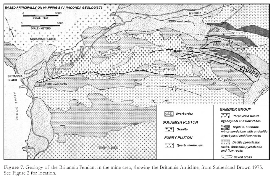
Information Sources
4 Information regarding the regional geological setting of the Britannia deposits is available in Geological Survey of Canada (GSC) publications. Much of the information regarding the operations at Britannia was obtained from the annual reports of the British Columbia Ministry of Mines and Petroleum Resources and its predecessor the BC Ministry of Mines (referenced throughout this article as ARBCMM), and from several reviews that appeared in Geology, Exploration and Mining, also published annually by the BCMM (the Ministry is now named the BC Ministry of Energy and Mines). Numerous articles on the geology, mining and milling at Britannia Mines have been published in professional journals, especially in the transactions and bulletins of the Canadian Institute of Mining and Metallurgy. Significant collections of archival material relating to Britannia are held by the British Columbia Provincial Museum and by the Special Collections department of the University of British Columbia. The Britannia Mine Museum document and photo archives are a rich source of information and Mullan (1992), former Executive Director of the Britannia Mine Museum, wrote an informative review article.
GEOLOGICAL SETTING
Regional Geology
5 The earliest geological descriptions of the Britannia area were general reports by LeRoy (1908), McConnell (1915) and Schofield (1919) of the Geological Survey of Canada. Bostock (1963) and Roddick (1965), also of the GSC, mapped areas adjacent to the Britannia area and Lynch (1991) and Monger (1993) conducted studies of the Gam-bier Group, the host rocks to the Britannia deposits.
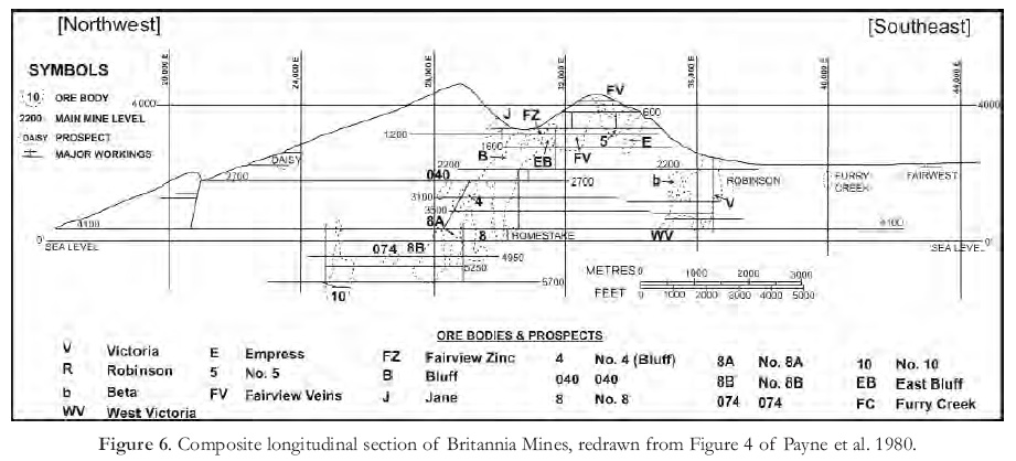
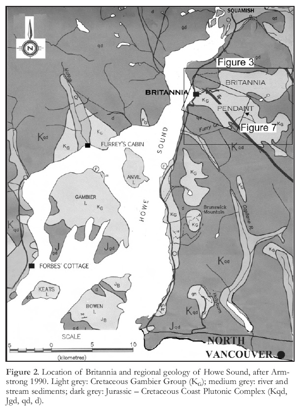 Display large image of Figure 2
6 The Gambier Group is preserved within and adjacent to the Mesozoic to Cenozoic Coast Plutonic Complex (Fig. 2). It lies unconformably on early phases of the complex, and is intruded by later phases, within which it occurs as roof pendants. Gambier Group exposures extend from near the southern end of the complex northwestward for about 550 km, where they terminate south of the Skeena Arch (Massey et al. 2005). Strata of broadly similar lithology and age occur within the Skeena Arch and northwestward into the Alaska Panhandle. These northern assemblages are included in the Gambier Group on the Tectonic Assemblage Map of the Canadian Cordillera (Wheeler and McFeely 1991). In southwestern BC, roof pendants of Gambier Group are spread across the width of the Coast Plutonic Complex, from Howe Sound in the west to Harrison Lake in the east, a distance of approximately 100 km. Over a dozen roof pendants of Gambier strata are present in the Vancouver North and adjacent map areas , which includes Howe Sound (Roddick 1965).
7 The Gambier Group in southwestern BC comprises arc-related marine and non-marine volcanic and clastic sedimentary rocks that were deposited along the eastern margin of Wrangellia during the Early Cretaceous, and deformed in response to subduction during the Late Cretaceous (Lynch 1992, 1995). In the Brunswick Mountain pendant, about 15 km south of Britannia (Fig. 2), Roddick (1965) divided the Gambier Group into three assemblages, an upper, dominantly volcanic assemblage, a middle sedimentary assemblage dominated by argillite and slate, and a lower, dominantly volcanic assemblage. This division of the Gam-bier Group is generally applicable in southwestern BC. Both the lower and upper volcanic assemblages are generally calc-alkaline and include units of basalt, andesite, dacite and rhyolite. Gambier strata locally lie unconformably on Jurassic rocks of the Coast Plutonic Complex, or on basement metamorphic rocks; in the Vancouver North map area, the base of the lower volcanic assemblage is characterized by conglomerate containing cobbles of granodiorite lithologically identical to rocks of the local Coast Plutonic Complex (Roddick 1965). Fossils collected from eastern exposures of Gambier strata, near Harrison Lake, indicate a Hauterivan age (136 – 130 Ma; Arthur et al. 1993). In the Howe Sound area, fossils collected by W.H. Mathews from strata near the base of the lower volcanic assemblage north of Britannia also indicate a Hauterivan age (Monger 1993). A cephalopod fossil collected by W.H. Tipper 10 km south of Britannia was determined to be of Albian age (112 – 99.6 Ma; Lynch 1995).
8 Roddick (1965) cautioned that a useful stratigraphic description of the Gambier Group in the Vancouver North and adjacent areas is impossible because of the discontinuous nature of outcrops, large variations in lithology over short distances, and because nowhere in the area are all the units in the sequence well exposed.
Geology of the Britannia Pendant
9 Several prominent topographic features are present in the Britannia area: Britannia Creek flows westward to Britannia Beach from mountain lakes about 9 km east of Howe Sound. Goat Ridge (elevation over 1500 m) lies north of Britannia Creek, and Britannia Mountain (elevation 1463 m) lies south of it (Fig. 3). On the south side of Britannia Mountain, Furry Creek flows westward into Howe Sound (Figs. 2, 3).
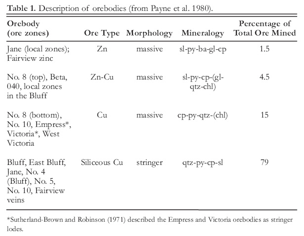
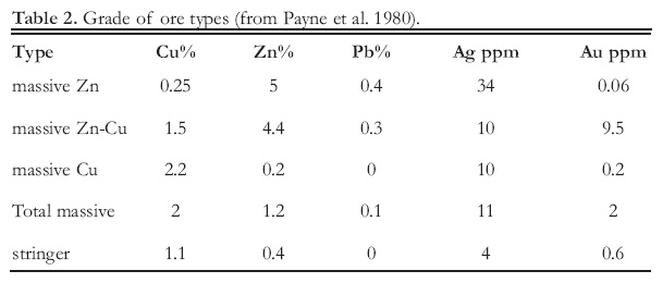
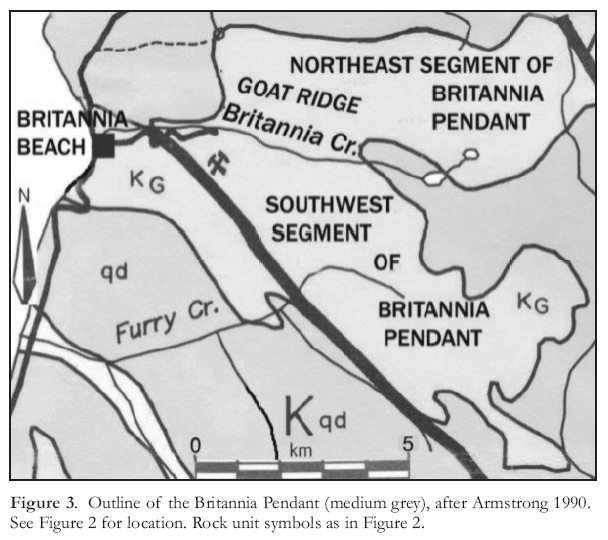 Display large image of Figure 3
10 The area is underlain by Gam-bier Group strata, which form a roof pendant, commonly referred to as the Britannia Pendant, within the Coast Plutonic Complex (Fig. 3). The Britannia Pendant consists of two lobes or segments, a northeast segment lying east of Goat Ridge and a southwest segment lying south of Goat Ridge. The Britannia deposits underlie Britannia Mountain within the southern segment, which is about 2 to 4 km wide and extends 14 km in an east-south-easterly direction from Britannia Beach (Fig. 3).
11 Lynch (1990, 1991) described the stratigraphy of the Gambier Group within the Britannia Pendant and elsewhere in the Howe Sound area as "...two broad volcanic complexes, separated by a predominantly clastic sedimentary unit. These effectively correspond to the ‘Lower’, ‘Middle’ and ‘Upper’ subdivisions of Roddick (1965)." Broadly speaking, Lynch’s ‘lower volcanic complex’ underlies the northeast segment of the Britannia Pendant, his middle clastic interval underlies parts of Goat Ridge and parts of the southern segment, and his ‘upper volcanic complex’ underlies much of the southern segment and parts of Goat Ridge. Lithotypes within the lower and upper volcanic assemblages are similar, except for the presence in the lower assemblage of basal conglomerate and arkose (Lynch 1991). The middle clastic interval is characterized by shale, siltstone, wacke, and lesser sandstone and breccia, and is tuffaceous in places. Upper members of the middle interval are intercalated with subaqueous basaltic and andesitic members of the upper volcanic assemblage.
12 The upper volcanic assemblage comprises basalt and andesite flows, felsic and heterolithic volcanic breccia, bedded tuff, argillite, chert, and bodies of porphyritic dacite. The flows are variably massive, vesicular, pillowed and autobrecciated, and in places contain interbeds of tuff and argillite. Some porphyritic dacite bodies are sill-like and others have no discernable shape. The detailed stratigraphy within the Britannia Pendant has not been established because of abrupt changes in thickness, lack of continuity, and deformation. Lynch (1991) estimates the stratigraphic thickness of the Gambier Group in the Howe Sound area to be over 4500 m. He estimates the thickness of the middle interval to be about 500 m but does not offer an estimate of the thickness of the upper and lower volcanic assemblages. James (1929) and Payne et al. (1980) estimate the stratigraphic sequence in the southern segment of the Britannia Pendant alone to be over 1525 m thick.
13 The age of Gambier strata in the Britannia Pendant is loosely bracketed by Late Jurassic granodiorite on which the lower volcanic assemblage in the northeast segment rests unconformably (Lynch 1990), and by Early Cretaceous to Early Tertiary granodiorite of the Squamish Pluton, which intrudes the upper volcanic assemblage in the southern segment (Bostock 1963). The Squamish Pluton returned a tentative K–Ar age of 92 ± 4 Ma (White 1968), and a U–Pb zircon age determination on rhyolite from the lower volcanic assemblage in the northeast segment yielded an age of 112.0 ± 0.3 Ma (i.e. Albian; Lynch 1995).
14 Strata in the Britannia Pendant have been folded, faulted and altered by regional greenschist facies metamorphism and local contact metamorphism. Rocks display cleavage, schistosity and small-scale folds, most of which have northwesterly trending axes (Lynch 1990). Large-scale folds have not been identified, except in the mine area. Both segments contain north-westerly trending, steep southwesterly dipping thrust faults that can be followed for several kilometres. Shorter normal faults trend northwesterly or northeasterly across the structure.
15 The Britannia Shear Zone (Fig. 4), within which the Britannia orebodies lay, extends the length of the southwestern segment (Payne et al. 1980), from Britannia Beach southeast-erly, more or less parallel to the structural grain. It varies in width from about 0.6 to 1.3 km.
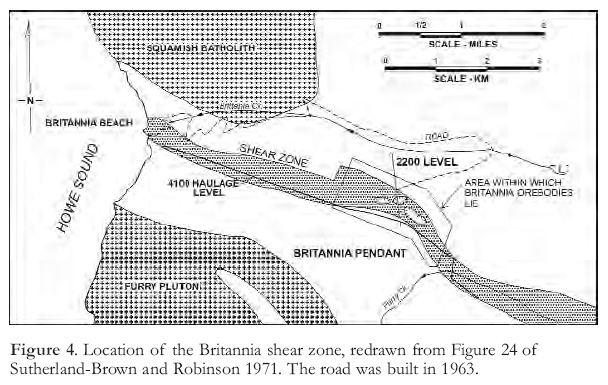 Display large image of Figure 4
Mine Geology
16 Schofield (1926) published a detailed account of the mine geology, and James (1929) authored a GSC Memoir that provided detailed geological descriptions of the Britannia Pendant and the mine. James (op. cit.) had been employed by the Britannia Mining and Smelting Company (BM&S Co.) for several years before he joined the GSC, and consequently he was able to draw upon data gathered by mine geologists as well as by the provincial and federal geological surveys. The result was an account that served as a framework for subsequent investigations for decades to come. Papers by Sutherland-Brown and Robinson (1971), Sutherland-Brown (1972, 1975), and Payne et al. (1980) provide the most recent descriptions and interpretations of the Britannia deposits. Numerous company geologists have contributed directly and indirectly to these and other publications, as have geology students, mostly from UBC, who have written theses on the Britannia deposits. A capsule report on the geology of Britannia appears in the Britannia link of the BC Ministry of Energy and Mines MINFILE website [ http://minfile.gov.bc.ca/].
Lithology and Structure
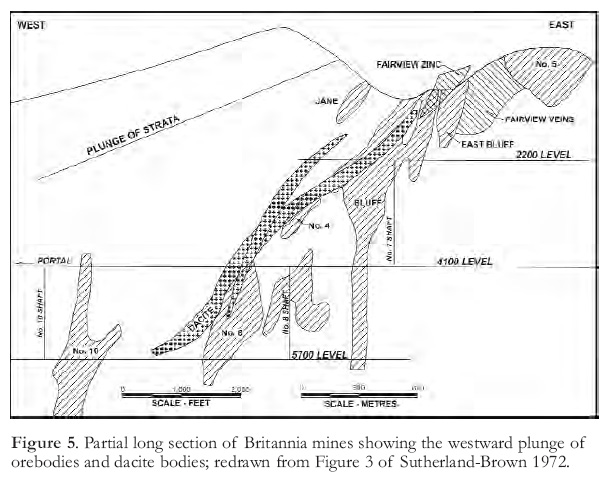
17 Lithological units recognized at the mine scale of mapping and the names given them have varied over the decades, as have interpretations of structure and origin of the deposits. In part this is because the stratigraphy, even at the mine scale, is discontinuous, but also because regional and dynamic metamorphism have masked and disrupted the original appearance and composition of the rocks. However, certain general aspects of the geology are commonly accepted; for example, (a) the rocks in which the shear zone formed and the strata in the hanging wall and footwall of the shear zone were laid down in an active volcanic region that for major intervals was partly submerged; (b) the Britannia Shear Zone is a product of ductile shear deformation; and (c) most of the orebodies occur in green mottled schist and show a spatial relationship with bodies of dacite (Fig. 5).
18 The stratified succession in the mine area comprises two sequences, a dominantly pyroclastic sequence and an overlying argillite and siltstone sequence containing minor tuff (Sutherland-Brown and Robinson 1971; Sutherland-Brown 1975; Fig 5). A transitional interval between the sequences is characterized by mixed crystal tuff and well-bedded grey and green argillite. The upper part of the pyroclastic sequence is composed largely of dacitic, lapilli-rich pyroclastic flows and minor argillite beds, interbedded with and overlain by plagioclase crystal tuff. Andesitic dykes (and possibly some flows) were emplaced early in the evolution of the mine sequence. They are deformed and in places mineralized. Sill-like bodies of porphyritic dacite were emplaced later; they are locally slightly deformed along their margins, and weakly mineralized, probably by remobilized sulphides. Schofield (1926) and James (1929) described masses of anhydrite and gypsum in the Fairview Mine (Fig. 6), located apart from the sulphide bodies. They lie in the plane of foliation, contain no other minerals and are up to 5 m thick and 30 m long in a down dip direction. One year Britannia mined and shipped several hundred tons of gypsum from these bodies. Barite is described as a common gangue mineral in zinc-rich parts of the Jane and Fairview orebodies.
 Display large image of Figure 5
19 The Britannia Anticline (Fig. 7) and the Britannia Shear Zone (Fig. 4) are the principal structures in the mine area. The anticline trends north-westerly to westerly, is overturned to the northeast, and is flanked on the northeast by a sub-parallel syncline. West of the Jane Mine, where schistosity is less strongly developed than elsewhere in the shear zone, the nose of the Britannia Anticline can be observed to plunge about 20° westward (Sutherland-Brown and Robinson 1971). The Britannia Shear Zone, which also, in general terms, trends northwesterly, was superimposed on the Britannia Anticline. In the mine area, the shear zone ranges in width from 400 to 800 m and is not confined to one rock type. It is characterized by a strong southward-dipping schistosity and is bounded on both sides by southward-dipping faults, which Sutherland-Brown and Robinson (1971) suggest are en-echelon in character.
20 Original mineral assemblages and textures in the mine area have been altered, first by regional metamorphism to lower-greenschist facies, and then by dynamic metamorphism and metasomatism. Primary bedforms in the zone have been obliterated, except for small fragments of beds that lie sub-parallel to schistosity. Any mineral assemblages that formed as alteration haloes related to postulated pre-deformational sulphide deposition, or that formed during regional metamorphism, were modified during the episodes of dynamic metamorphism described below (Payne et al. 1980).
21 In mine geology terminology, the main components of the shear zone are chlorite mottled schist, quartz-sericite (chlorite) schist, bodies of schistose and fragmental andesite, and dacite dykes and sills. Chlorite mottled schist, in which most orebodies are found, is believed to be the schistose equivalent of dacitic tuffbreccias. Quartz-sericite (chlorite) schist (the ‘silver schist’ of former geologists), which does not contain orebodies, is thought to have formed from argillite by isochemical metamorphism (Sutherland-Brown and Robinson 1971).
22 Payne et al. (1980) recognized five stages of deformation in the mine area. The first (D 0) produced the Britannia Anticline and other flexural-slip folds (F 0) with sub-horizontal to gently plunging axes trending west-northwest. Following the development of the Britannia Anticline, successive episodes of shear deformation produced the Britannia Shear Zone and the multiple generations of textures within it. The first episode (D 1) produced a strong west-northwest trending, steeply southward dipping schistosity (S 1), defined by parallel chlorite and sericite plates and flattened lithic fragments. Small isoclinal folds with axial planar S 1 schistosity were formed during this episode. Outside the shear zone and in competent blocks within the zone that are thought to be andesitic intrusions, S 1 is present but is much less intensely developed. A subsequent episode of shear deformation produced another schistosity (S 2) that is sub-parallel to S 1 and deforms it. Late deformation (D 3 and D 4) produced a locally developed schistosity (S 3) that is parallel to northeast-trending faults, and a widespread fracture cleavage (S 4) that is locally prominent, for example, in No. 10 mine.
23 The shear zone is transected by a number of late faults, many of which are subparallel to the schistosity and margins of the shear zone. In the eastern part of the area a series of these faults branch off a major foot-wall fault, and in the western part of the mine area, oblique faults converge westward and upward to form a single major fault (Payne et al. 1980).
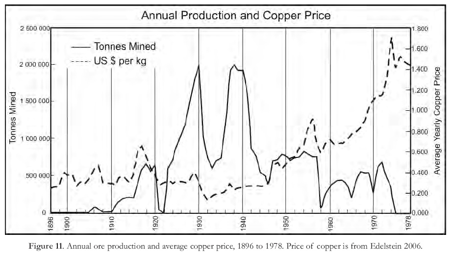
Ore Bodies
24 The most distinctive feature of the Britannia orebodies is that they all lay within the Britannia Shear Zone. They were distributed over a horizontal distance of approximately 3700 m and a vertical range of 1800 m (Fig. 6). The horizontal extent of known mineralization, which includes non-economic sulphide deposits northwest and southeast of the mined deposits, is about 6000 m. As the Britannia deposits were developed, the opinion formed that orebodies occurred at or near the footwall of the shear zone. However, Glen Waterman, the Anaconda geologist who examined the geological data before Anaconda purchased Britannia, concluded that seams, stringers and veins of mineralization were widespread in the shear zone (Waterman 1970). He reported that "the study clearly indicated that ore was not only localized along the footwall of the shear zone but occurred in intermediate positions between the hanging wall and footwall". The subsequently discovered 040 and No. 10 ore bodies lay some 800 feet (244 m) into the shear zone from the footwall. Orebodies occurred as massive and stringer deposits. Both types lay approximately in the plane of schistosity (S 1), although in detail they crossed the schistosity at small angles (Sutherland-Brown and Robinson 1971).
 Display large image of Figure 6
 Display large image of Figure 7
25 Within the deformed and altered rocks of the shear zone, possibly near the top of the pyroclastic sequence described by Sutherland-Brown and Robinson (1971) and reported above (Lithology and Structure section), Payne et al. (1980) recognized a unit of dacitic tuffs and breccias (their ‘Bluff tuff-breccia’) overlain by andesitic sedimentary and tuffaceous rocks (the term ‘possibly’ is used here because descriptions of rock units by different authors are comparable only in a general sense, not in detail). They reported that massive deposits occur along or slightly above the top of the dacitic Bluff tuff-breccia, commonly in or near cherty andesitic rocks, whereas stringer deposits occur mainly in silicified tuff-breccias below the contact of the two units. Sutherland-Brown (1975) reported that mineralization of some type is common at or near the contact between "crystal-rich dacitic pyroclastic rocks and the green andesitic siltstones" (i.e. the contact between the dacitic pyroclastic rocks and overlying argillite–siltstone sequence of Sutherland-Brown and Robinson 1971). Seemingly, Sutherland-Brown (1975) and Payne et al. (1980) were referring to the same stratigraphic interval when describing the location of mineralization.
26 Sutherland-Brown and Robinson (1971) described both massive and stringer orebodies as heterogeneous mixtures of sulphides, remnant host rocks and discrete veins. Near or adjacent to some orebodies, as well as elsewhere in the shear zone, sulphides occur as disseminations, bedding plane concentrations and small stringers. Horses (relict masses) of host rock recognizable as chlorite mottled schist or andesite commonly occurred within orebodies (Sutherland-Brown and Robinson 1971).
27 Pyrite was the main sulphide mineral in both types of orebodies, and was accompanied by much less abundant chalcopyrite and erratically distributed sphalerite and galena. Tennantite, tetrahedrite, argentite, pyrrhotite and native gold occurred sporadically and sparingly. Associated non-sulphide minerals were principally quartz, muscovite and chlorite, and in some orebodies barite and anhydrite were present.
28 Massive ore bodies, namely the Bluff, No. 5, No. 8 and No. 10, had a zoned structure consisting of a chalcopyrite-rich core surrounded by a lower grade copper zone and overlapping pyrite- and silica-rich zones (Sutherland-Brown and Robinson 1971). Zinc-rich ore was present in the upper central parts of some massive orebodies and gold was clearly most abundant in the massive zinc–copper bodies. Galena formed irregular inter-growths with sphalerite and was abundant in a few thin layers in zinc and copper–zinc ore (Payne et al.1980). Andesitic, tuffaceous sedimentary rocks flanking and above massive ore bodies locally contained abundant disseminated pyrite as well as anhydrite, barite and cherty zones (Payne et al. 1980).
29 The only ‘truly stratified’ sulphide-bearing zones were found in the Fairview Zinc orebody and in pyritic green siltstones overlying it (Sutherland-Brown 1974). The Fairview Zinc orebody was a metre-thick, sheet-like body of massive ore containing pyrite, chalcopyrite, sphalerite and thin beds and disseminations of barite. Stringer orebodies, such as the Empress and Victoria zones, consisted of veins of chalcopyrite, pyrite, and lesser quartz. They were typically associated with broad zones of silicified rock containing quartz and quartz–pyrite veins (Payne et al. 1980).
30 Table 1 is a compilation of some generalized features of Britannia orebodies. Some orebodies were not uniform in character; for example, No. 8 orebody graded from zinc–copper ore at the top down into copper ore, and the Bluff orebody contained both massive and stringer ore. The Beta, West Victoria, East Bluff and No. 4 orebodies (Table 1; Fig 6) were either small or else were subdivisions of principal orebodies; they are not discussed in this paper. Table 2 reports the average tenor of the different types of ore mined. It shows that, by far, most of the ore at Britannia was stringer ore. The average grade of all ore mined was approximately 1.2% Cu, 0.6% Zn and 0.6 g/t Au. Variations in tenor were sufficient to allow selective mining in response to variations in metal prices. For example, in 1943, ore reserves were divided into 3 classes, copper ore, with an average grade of 1.22% Cu, copper–gold ore, with a tenor of 0.67% Cu and 0.097 oz/ton Au, and copper–gold–zinc ore with a tenor of 1.72% Cu, 5.49% Zn and 0.04 oz/ton Au (BM&S Co. Ltd. Annual Report 1943).
Structure and Origin of Deposits
31 Between 1963 and 1974, when Anaconda Canada operated Britannia Mines, Anaconda geologists re-logged old drill core, remapped old mine workings and mapped new mine workings that were opened during this period. They collected much more data than were previously available, and contributed significantly to the previously cited publications by Sutherland-Brown and Robinson (1971), Sutherland-Brown (1972, 1975) and Payne et al. (1980). These publications span the period during which the perceived origin of the Britannia deposits changed from a structurally controlled epigenetic model to a volcanogenic massive sulphide model.
32 Prior to 1970, the Britannia deposits were generally believed to have formed from hydrothermal fluids that emanated from an underlying pluton, migrated upwards through permeable zones in the shear zone and replaced susceptible rocks within the shear zone. Schofield (1926) proposed that the Bluff, Empress and Victoria deposits were located in wedges of shear zone rocks that had been faulted into black slate in the footwall of the shear zone. The impermeable slate thereby formed ‘hoods’ that trapped ore fluids rising through the permeable schist. Ebbutt (1935) suggested that fracture zones in northwesterly plunging drag folds that had developed during movement along a major fault in the footwall of the shear zone provided the loci for sulphide deposition from ore fluids that had risen along the fault zone from a deep-seated igneous source. Irving (1948) proposed that fracturing of competent green mottled schist in the hangingwall of a fault in the footwall of the shear zone allowed ore fluids to ascend along the fault to favourable loci for deposition. The spatial relationship between orebodies and dacite sills (Fig. 5) has led many authors to suggest a genetic relationship between the dacite and ore deposition.
33 The pre-purchase geological review and the early investigations by Anaconda mine geologists led them to support a structurally controlled model for ore deposition. When describing this early work, Waterman (1970) wrote "Ore controls appeared to be structural, with relative rock competence of greater importance than particular rock units".
34 Sutherland-Brown and Robinson’s (1971) paper was based on detailed surface mapping in the mine area and on data acquired by Anaconda geologists. They concluded that although there was insufficient information to ascertain the process of ore deposition, the evidence suggested that, apart from the sheet-like Fairview Zinc deposit, the orebodies were formed by replacement after the development of schistosity. They commented, however, that the deposits had "great similarity to the Keiko ore of Japanese Kuroko deposits" and suggested that the source of mineralizing fluids might have been a solfataric field. In subsequent publications, Sutherland-Brown (1972, 1975) described Britannia orebodies as massive sulphide deposits and noted that some of the massive orebodies contain, in places, textures indicative of deformation, flow and annealing.
35 Payne et al. (1980) pointed out that "a critical factor regarding the origin of the Britannia sulphide deposits is whether they are pre- or post-D 1 (and D 2)". In other words, which came first, sulphide deposition or the development of the first and most intense episode of shear deformation? Aided by considerably more mine geological information than was previously available, including textural and chemical data, they concluded that host rocks were initially altered by volcanogenic hydrothermal solutions associated with pre-deformation sulphide deposition. Alteration patterns that developed during subsequent deformation were imposed upon and reflect the pre-existing ore-stage alteration. In summary, they stated that the "deposits formed from hydrothermal and exhalative solutions related to contemporaneous dacitic volcanism and then deformed during later shearing and faulting." Most of the orebodies are either cut by or have contacts at or near late faults. Based on a pre-deformation reconstruction across fault zones, they suggested that the various Britannia orebodies may represent segments of two original massive sulphide deposits.
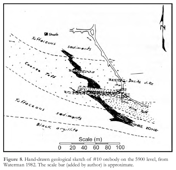
36 The publication by Payne et al. (1980) generated a discussion initiated by Waterman (1982) and responded to by Stone and Payne (1982). Waterman expressed the opinion that deposition occurred in structures that developed during the formation of the shear zone. In support of his opinion, he cited geological mapping on the 5900 level of No. 10 mine that showed the ore zone cutting across lithological boundaries (Fig. 8), a feature that is at odds with a model that invokes syn-genetic ore formation. Stone and Payne (1982) responded by referring to data collected by Anaconda geologists during the 1970s, most of which, in their opinion, supported a model of ore deposition in which the massive sulphide bodies were genetically related to certain felsic volcanic units in the mine sequence, and were deformed during deformation of the enclosing rocks. Both papers referred to data that were collected by Anaconda geologists and never published; they are now probably buried in Anaconda’s archives. It is unfortunate that Britannia closed before these data were published and subjected to discussion. However, regardless of how the Britannia orebodies were formed, the mining operation that they supported was a significant event in BC and Canadian mining history, and it is that subject with which the rest of this article is concerned.
 Display large image of Figure 8
DISCOVERY AND EARLY DEVELOPMENT
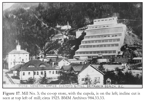
Discovery
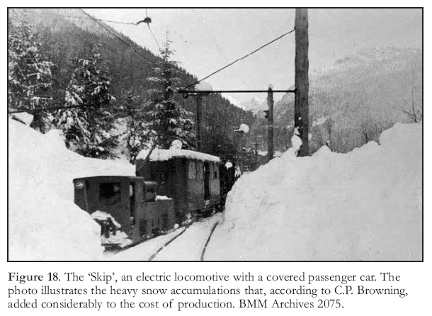
37 The discovery of Britannia is credited to Dr. A. A. Forbes, a medical doctor with a keen interest in prospecting, although Forbes himself gives partial credit to a fisherman named Granger. In 1888 Forbes was a medical officer for the small communities around the western entrance to Howe Sound. He occupied a cottage approximately 30 km from the mouth of Britannia Creek near what is now Hopkin’s Landing (Fig. 2). His attention was drawn to Britannia Mountain by a fisherman named Granger who showed him a copper stained rock and offered to show him its source for a fee of $400. Granger took Forbes to a site near the summit of Britannia Mountain, but the area was mostly covered with snow and the visible outcrops contained nothing of interest. The next day, while prospecting lower on the mountain, Forbes spied and shot a buck. In its death throes the buck kicked moss off an outcrop and exposed some mineralization. Forbes uncovered what he described as a "good showing" and, upon a promise of secrecy, paid Granger $400. Granger bought a boat and sailed for Alaska, never again to be associated with Britannia.
38 The above account was recorded some 40 years later by Cecil Scott, a reporter with The Vancouver Province (Scott 1931). Forbes summarized the discovery for Scott with the following comment: "So the first discoverer of copper at Britannia was Mr. Granger, the second was Mr. Buck and the third was Dr. Forbes". While the story seems implausible, it certainly is not the only colourful account of an accidental mineral discovery.
39 Forbes worked on his showing periodically for eight years but did not stake it because he believed that since gold, not copper, was the commodity of interest at the time there was no danger of the showing being staked by someone else. In 1893, he unsuccessfully sought aid from the provincial government to explore his discovery. He lost interest in his find and, according to the interview recorded by Scott (1931), in 1897 he gave a chart showing the location of his Britannia showing to a Mr. Turner, a man with interests in mining whom he had befriended. Forbes told Scott that he believed the chart he gave Turner was later used by Oliver Furry, who first staked claims on Britannia Mountain.
40 In 1898, the Britannia and Empress claim groups were staked by Oliver Furry, a trapper who had a cabin on the west side of Howe Sound, 18 km by water from the mouth of Britannia Creek (Fig. 2). All the Britannia orebodies were discovered within these claim groups. Furry staked the Britannia Group as agent for friends and family of Thomas T. Turner, and the Empress Group as agent for Joseph Boscowitz and his sons Leopold and David. For example, the declaration of staking of the Jane Claim contains the wording "Initial post No.1, ‘Jane’ Mineral Claim located by Oliver Furry for Thos. T. Turner" (BC Ministry of Energy and Mines, Mineral Titles Branch 1898). Furry staked only one claim (the Mineral Creek) in his own name. Leopold Boskowitz, of the fur trading firm of Boscowitz and Sons in Victoria, purchased half of Furry’s interest in the Empress Group, and in 1899 Boskowitz bought the Britannia Group claims either from the people in whose names Furry staked the claims or from Turner, who had already acquired some of the claims from their owners. According to the Bills of Sale, which are included in the above mentioned staking declarations, the total price paid by Boscowitz for the Britannia Group of five claims was $20 200. To summarize, the actual staking of the Britannia and Empress groups was done by Furry acting as agent for others, and T. T. Turner organized the staking on behalf of Leo Boscowitz, who, with other members of his family, subsequently obtained control of the claims. In a legal challenge, the Boscowitz family alleged that Furry’s share of the claims he had staked on their behalf (the Empress Group) should be reduced from 50 to 20%, due to certain signing irregularities. The case was decided by the Supreme Court of Canada in favour of Furry.
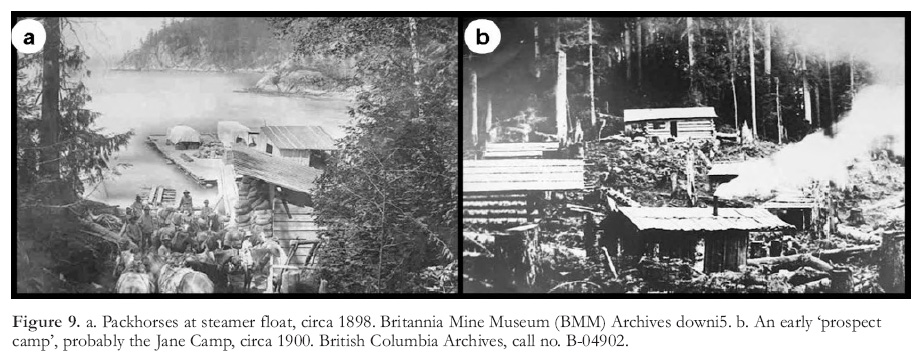 Display large image of Figure 9
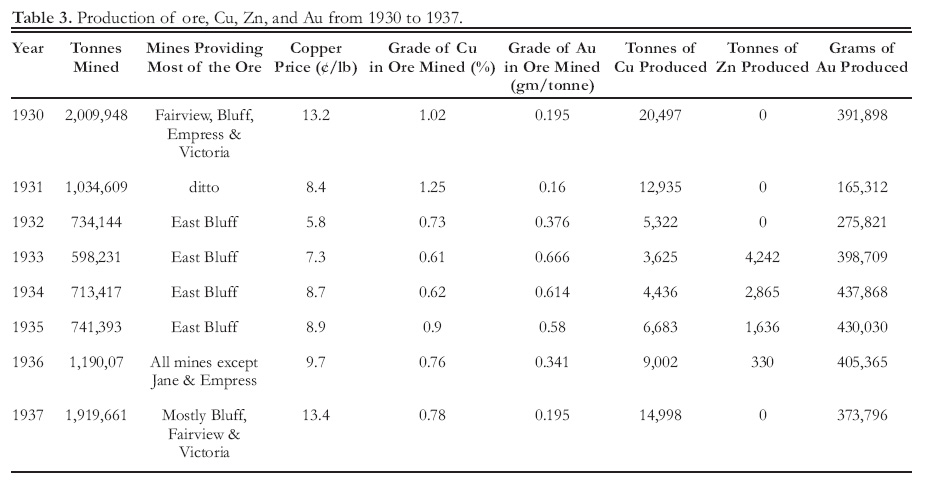
41 One wonders what led Furry, a trapper by vocation and not a prospector, to the Britannia showing located high in the mountains on the opposite side of Howe Sound from his cabin, if he did not have directions. Thomas Turner was a Vancouver furrier with whom Furry might have done business. If the Mr. Turner to whom Forbes gave a chart of his Britannia discovery was Thomas Turner, it is probable that, with chart in hand, Turner hired Furry to stake Forbes’ discovery. Alternatively, it is possible that Furry discovered Britannia without guidance. If he had, by chance, wandered through the area he would very likely have noticed a prominent, copper-stained bluff that subsequently became known as Mammoth Bluff. The bluff is located on one of the claims Furry staked. Regardless of the roles played by Forbes, Turner and Furry, it is remarkable that the claims staked by Furry should have covered all the main ore deposits of Britannia Mines (Figs. 4, 6).
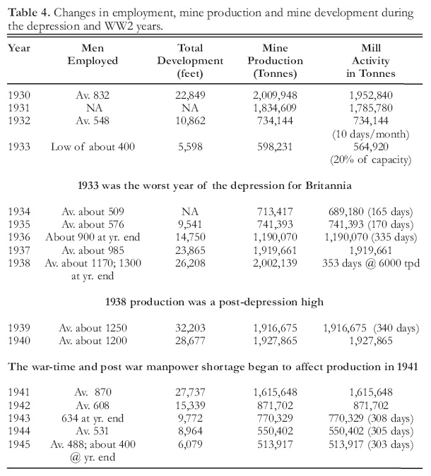
42 It has been reported (Haggen 1923; Ramsey 2004, p. 17-18) that a Vancouver merchant from whom Furry obtained supplies, Mr. W.A. Clark, grubstaked Furry on a 50–50 basis to stake claims on mineralization that Furry might come across. Clark obtained miner’s licenses in the names of his family and friends that Furry could use to record any claims he staked. Clark then left Vancouver to investigate recent placer gold discoveries in Atlin, BC, but when he returned some months later he found that Furry had staked the Britannia Group of claims, but had not recorded them using the miner’s licenses he had purchased for Furry. Unfortunately the grubstaking agreement between Clark and Furry is not documented and it is not known in what way, if at all, Clark benefited from grubstaking Furry.
Early Development and Corporate Organization
43 The Boskowitz group began development work in 1899. During that year, a 6.5 km horse trail was built from the mouth of Britannia Creek to the Jane claim in the Britannia Group, where the Jane Camp was established at about 1000 m above sea level (Fig. 9a, b). The results of tunneling and trenching were encouraging, and suggested the presence of a significant body of ore. However, the Boscowitz group was not experienced in the mining business, and they decided to seek a stronger partner to share the expense and management of continuing development. After visiting the property in late 1899, Howard Walters of Libby, Montana, an experienced mining investor, purchased a 70% interest in the venture for $35 000, leaving the Boscowitz group with a 30% interest (Haggen 1923). To raise development capital, Walters enlisted ten Vancouver business partners, with whom he immediately formed the Britannia Copper Syndicate Ltd.
44 As work progressed under the management of Walters it became apparent that a large amount of capital would be required to bring the Jane deposit into production. The syndicate was refinanced several times, largely with Vancouver money, and at one point shares were offered to the public at $800 to $1000 per share (Ramsey 2004, p. 20). However, additional financing was required. Although the property attracted wide interest, no purchasers came forward, possibly because the price being asked by the syndicate was reported to be in the $750 000 to $1 000 000 range (ARBCMM 1900, p. 930). In 1901, with the syndicate facing bankruptcy, George Robinson, a mining engineer from Butte, Montana, acquired an interest in the syndicate by paying off its liabilities.
45 Robinson obtained control of the syndicate in 1902 by purchasing Walters’ share and in 1903 he bought out the Boskowitz group (Ramsey 2004, p. 21). Robinson then reorganized the directorship and capital of the syndicate. The Hon. E. Dewdney (a future Lieutenant-Governor of BC) was appointed President of the new Board of Directors and financier Henry Stern of New York underwrote a new offering of Britannia Copper Syndicate shares. Stern incorporated the Howe Sound Company under the laws of the State of Maine, with a share capital of $2 000 000 (Ramsey 2004, p. 23). Grant B. Schley, a business associate of Stern’s who was a partner in the banking firm of Moore and Schley, invested heavily in the new company. Robinson, Stern and a future prominent manager of Britannia, J.W.D. Moodie, had been associated with the Tintic Mining Company or its subsidiaries in Utah, a company of which Schley was President (Strack 2011; O’Brien 1987). The Howe Sound Company acquired all the shares of the Britannia Copper Syndicate in 1904 in return for 200 000 Howe Sound shares worth $1 000 000. Howe Sound financed the further development of Britannia by floating a $1 000 000 convertible bond issue. Meanwhile, Schley acquired a controlling interest in the Howe Sound Company and a position on the Board. Robinson, who apparently had excellent management skills, took over management of the developing mine from Walters in early 1904 (Robertson 1905). Under Robinson, mine production began in 1904, but shipment of ore to a smelter did not begin until 1905. Unfortunately, Robinson’s untimely death in 1906 prevented him from participating in the growth of the mine he had brought into production.
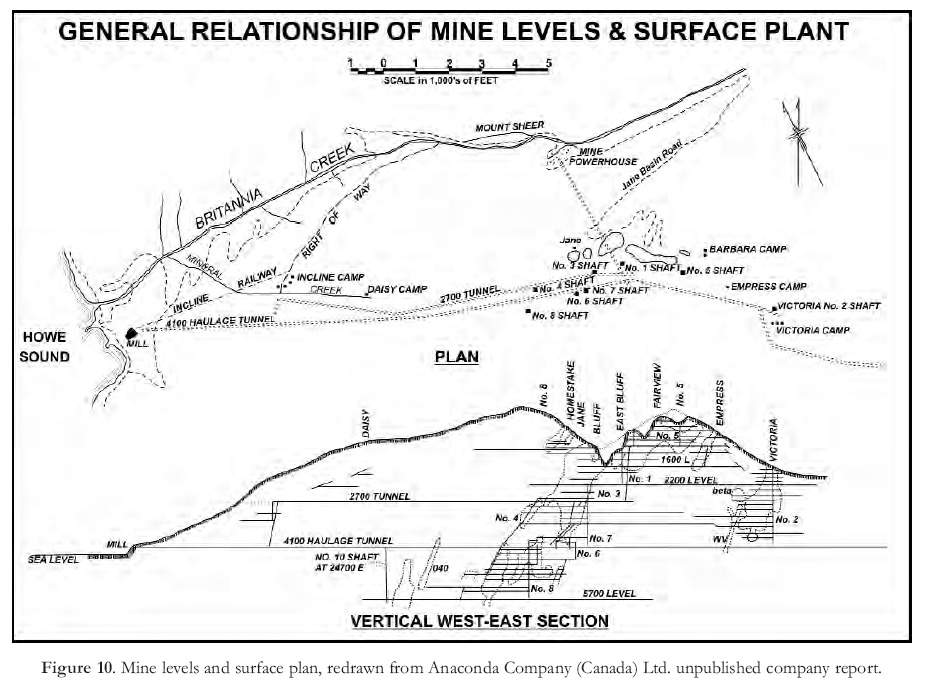 Display large image of Figure 10
46 In 1905, the Howe Sound Company created the Britannia Smelting Company to purchase the Crofton smelter on Vancouver Island; the Crofton smelter had been commissioned in 1902 to process ore from a nearby copper mine. The Britannia Power Co. Ltd. was formed to operate a hydroelectric power plant and dam, the first of several such installations that would enable Britannia to generate its own power for several decades to come. The final step in the corporate evolution of Britannia occurred in 1908, when the Howe Sound Company folded the assets of the Britannia Copper Syndicate, the Britannia Smelting Company and the Britannia Power Co. Ltd. into a single company, the Britannia Mining and Smelting Company (BM&S Co.), which was incorporated in BC. The Howe Sound Company, which was controlled by G.B. Schley, thus became the holding company of the Britannia operation and related assets. Much credit is due Schley for his steady and supportive guidance during the troubled financial times that were to follow.
THE BRITANNIA OPERATIONS
Mining
47 Mining at Britannia took place in a number of separate ore zones that were discovered at different times and initially developed and mined via different adits or internal shafts. Crews often lived in semi-temporary camps somewhat remote from the community and mill site at Britannia Beach (e.g. see Fig. 10). Consequently, it became customary in corporate documents and the literature to refer to these ore zones as ‘orebodies’ and ‘mines’ in their own right, e.g. the Bluff Mine and Victoria Mine or orebody. In terms of relative geographic position within the Britannia shear zone, from northwest (closest to Britannia Beach) to southeast, the mines were: No. 10 (discovered by Anaconda), No. 8, Jane (the first producer), Bluff, Fairview, No. 5, Empress and Victoria (Figs. 6, 10). Several lesser orebodies that were close to or extensions of principal ore zones were also given names, for example the East Bluff orebody, which could be considered part of the Bluff ore zone, and the small Beta orebody in the Victoria mine. In this article the terms ‘ore zone’, ‘mine’ and ‘orebody’ are used interchangeably. The Britannia operations are referred to as ‘Britannia Mines’, ‘Britannia Mine’ or simply ‘Britannia’, as was the custom. Britannia Beach was commonly referred to as ‘the Beach’.
 Display large image of Figure 11
48 The numerous mine levels (Figs. 6, 10) were named according to their approximate vertical distance in feet below a datum established on Britannia Mountain, early in the mine’s development, at an approximate elevation of 4300 ft (1310 m) above sea level.
49 The composition and grade of ore differed somewhat from mine to mine, and also between parts of a single orebody. Consequently, the cut-off grade and rate of production from a given mine (orebody) was not necessarily uniform, but varied in response to metal prices and other factors. Figure 11 shows the annual average copper price and annual ore production throughout the life of the mine.
50 Mine and mill production are expressed in this article as metric tons (mt), and copper prices are quoted in US¢/lb, uncorrected for inflation (except in Fig. 11). Mine levels and level intervals are referenced in feet, in accordance with the original designations.
51 A significant cost advantage at Britannia was that, except for No. 8 and No. 10 mines, the vertical component of ore transportation was largely gravity driven. During the first decade of production ore was transported to the mill at Britannia Beach from the Jane, Bluff and Fairview mines far above by aerial tram lines (Fig. 12a). The ore transportation system, which was a significant factor in mining cost, evolved through stages that increasingly relied on underground track (Fig. 12b) and ore-pass routes to avoid the inconvenience and expense of surface transportation.
52 The interplay between management skills, economic factors and unforeseen events was clearly responsible for Britannia’s remarkable 69 years of production and the attendant social history of the communities. For this reason the following account highlights significant operational activities and developments during the life of the mine. Much of the information regarding the operational aspects of Britannia was obtained from the annual reports of the BC Ministry of Mines (ARBCMM) and Ministry of Mines and Petroleum Resources.
1905
53 Production from the Jane Mine (Fig. 12c), as recorded by smelter returns, began in 1905, although ore-grade material encountered during exploration and development work prior to 1905 was stockpiled for later processing. Shipments to the company-owned Crofton smelter in 1905 included both mill concentrates and direct shipping ore, from which 285 mt of copper were recovered. The price of copper at the time was 15.6¢/lb (34.4¢/kg), which equates to $3.08/lb ($6.79/kg) in 2010 dollars. The managing director of operations in 1905 was George Robinson.
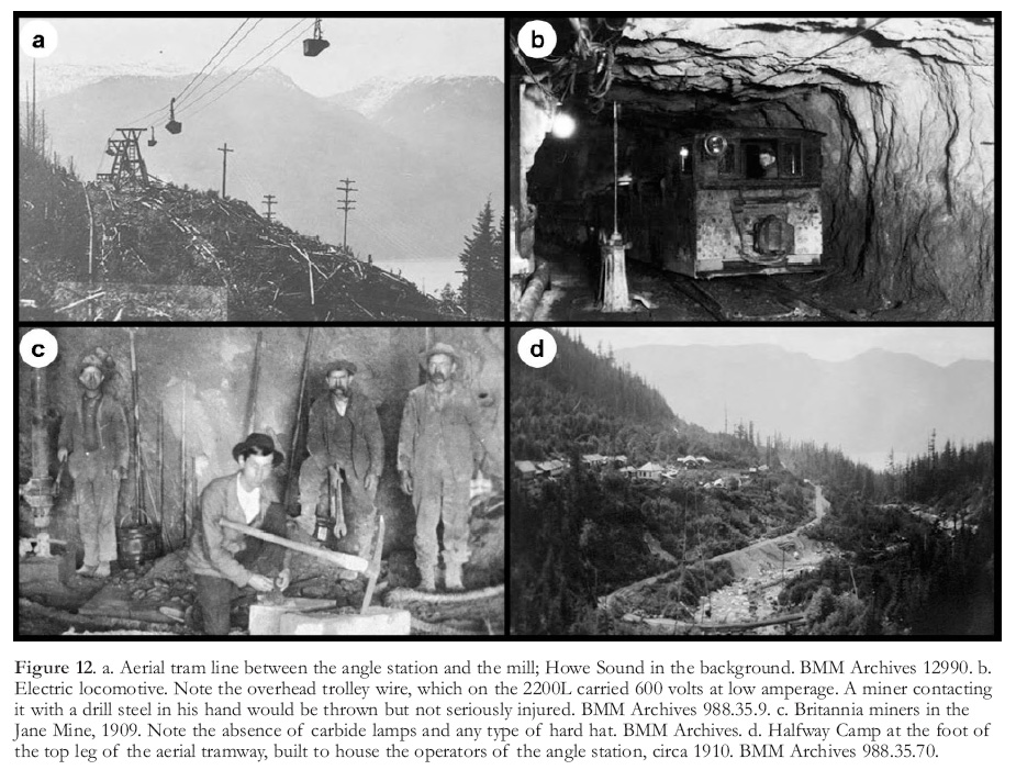 Display large image of Figure 12
54 The Jane Mine was 4.5 km east of Britannia Beach at an elevation of about 1020 m (Fig. 10). Ore was transported to the newly completed 200 tons-per-day (tpd; 180 metric tpd) mill at the Beach by a two-stage, aerial tramway 5150 m long, with a vertical drop of 980 m. The top leg of the tramway carried ore from the Jane Camp to a transfer station (the angle station) at the Halfway Camp, 435 m below (Fig. 12d). There it was transferred to the lower leg of the tramway (the legs of the tramway travelled in different directions).
1906 – 1915
55 This was a promising but difficult period for the young mine. Start-up problems naturally arose, the copper market was volatile, and the parent Howe Sound Co., with offices in New York, was periodically dissatisfied with operating results. In 1906, mine production and mill recovery of copper were not up to expectations because of problems with the tramway and the mill. Fortunately the mine was able to produce over 32 000 mt of direct-shipping ore that year, which partially compensated for the mill problem, and the operation remained marginally profitable. During 1907 the mill was redesigned in an attempt to improve recovery, but with disappointing results. Between 1907 and 1909 production fell to startup levels as a result of the continuing inability of the mill to produce a satisfactory concentrate, and the low price of copper (Fig. 11). Britannia was in danger of closing. However, in 1909 an exploration tunnel intersected what was to become the Fairview ore zone, and by 1911, development work, under the direction of mine manager R.H Leach, had outlined almost a million mt of 2.5 to 3% copper ore that was more amenable to concentration than the Jane ore. In 1911 Britannia was mining on six levels, and J. W. D. Moodie, who had assumed management late in 1911, was authorized by New York to make extensive improvements to the mine. One of these improvements, already started in 1909 by Leach, was a cross-cut adit that would become the 2200L haulageway, 1150 feet (350 m) below the lowest production level.
56 The encouraging performance of a new flotation circuit that was added to the mill in 1912 was undoubtedly a significant factor in the renewed confidence shown by the Howe Sound Co. (see the section on milling for recovery details). Production rose sharply to 212 500 mt in 1913, with ore coming from the Bluff and Fairview mines. However, in response to a sudden drop in the price of copper during late 1913 and early 1914, the Howe Sound Company ordered mining operations at Britannia to be cut back by about 50% and surface construction work to be suspended. During the month in which these cut backs were implemented – August of 1914 – World War I broke out. The price of copper suddenly rebounded and Britannia was again saved from possible closure. With the price of copper rising, a considerable volume of ore blocked out and the first phase of a new mill (No. 2) nearing completion, the future at Britannia must have appeared bright. However, in March of 1915 the Jane Camp was hit by a disastrous and deadly debris avalanche that claimed 57 lives and destroyed the top leg of the aerial tramway and many buildings (Fig. 13a, b).
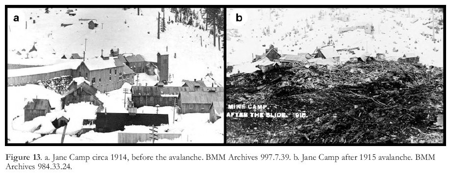 Display large image of Figure 13
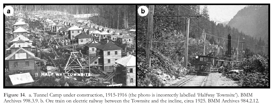 Display large image of Figure 14
57 A new system of ore transportation had to be put in place quickly. Fortunately, plans to close the Jane Camp and to revamp the ore transportation system had already been made, and construction was already underway. At the Tunnel townsite (Fig. 14a), so named because it was located near the portal of the recently driven 2200L adit, construction of bunkhouses and mine facilities was almost complete. An interior working shaft and an ore pass with a crushing and loading station at its bottom were raised from the 2200L adit to the Fairview mine 1148 feet (350 m) above (primary crushing continued to be done underground until the 1940s). The ore pass and the 2200L adit, which became the main haulageway, replaced the destroyed top leg of the aerial tramway. A two-stage system for transporting crushed ore from the 2200L underground loading station to the concentrator at the Beach, thereby reducing dependency on the lower leg of the tramway, was nearing completion. The first stage, a 5.6 km narrow-gauge surface electric railway between the 2200L loading station and the top of an incline 180 m below, was finished (Fig. 14b). The incline, designed to carry ore from the end of the railway down a steep slope to the mill, formed the second stage and was almost complete (Fig. 15a, b). The ‘Incline’ as it came to be known, consisted of a rail bed on which ore cars were lowered 1645 m by cable down a 27% grade to ore bins at the top of the recently completed No. 2 mill. At the top of the Incline a small camp was established that was later expanded to house miners driving the nearby 2700L adit. Near the top of the undamaged lower leg of the aerial tramway a new loading terminal was built and connected by rail to the 2200L loading station. The tramway was kept in service to deliver ore to the still operating No. 1 mill, which had been upgraded to handle 725 metric tons per day (mtpd). The damaged Jane Camp was abandoned and production resumed in June of 1915, only 3 months after the debris avalanche. The new system eliminated the high costs and inconveniences of operating the Jane Camp and the former upper leg of the tramway; it also provided better and safer accommodation at the Tunnel Camp, and facilitated the increase in production that was to follow.
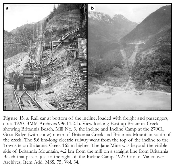 Display large image of Figure 15
58 However, production was interrupted again from September to December of 1915 by a shortage of hydroelectric power caused by falling water levels in the reservoirs that supplied the power plants. This necessitated steps to provide a more reliable source of power. The power facilities are described in a later section.
1916 – 1919
59 The WW I demand for copper, which was used in the production of brass shell casings, pushed the price of copper to an average of 29.2¢/lb by 1917. The Britannia mill came under the jurisdiction of the Imperial Munitions Board, a British agency charged with providing adequate supplies of metals for the war effort by overseeing supply and production facilities within the British Empire. Ore from the Fairview and Empress mines and from five ‘glory holes’ (open pits) in the upper Fairview mine was being carried by the new transportation system to mills 1 and 2 at the Beach. Production increased from about 200 000 mt in 1915 to 663 000 mt in 1918 and remained close to this level during the next two years, in spite of falling copper prices after the war ended. In 1916 Britannia became the largest copper mine in the British Empire (Mining and Engineering Record 1923).
60 Two adits that would become major haulageways beneath the main ore zones (namely the Jane, Bluff, Fairview and Empress mines; the Victoria orebodies had not yet been discovered) were begun in 1916 below the 2200L. One was collared at the 2700L adjacent to the top of the incline, and the other at the 4100L near the top of No. 2 mill (Figs. 6, 10). These adits and their associated ore passes would eventually replace the surface railway and the incline in the ore transportation system.
61 In 1916, construction of the Barbara Camp (Fig. 10) began at the 500 level on the southeast side of Britannia Mountain, and the Fairview and Empress mines were connected, thereby providing a second passageway through Britannia Mountain. At least four other levels would break through to the Furry Creek side of Britannia Mountain in subsequent years. Also, in 1916, the second 900 mtpd unit of Mill No. 2 was finished. The Tunnel town site became known as the Tunnel Camp about 1918.
62 Although mine production reached a new high in 1918, operations were hampered by the Spanish Flu pandemic, which had a tragic effect on the Britannia community (see section titled Disasters).
1920 – 1922
63 W. D. Moodie, who had been General Manager since 1911, retired in August, 1920. Many of the operational decisions that enabled Britannia to become such a successful mine were made under his leadership. B.B. Niedling was manager for a brief period, and later in 1920 E.J. Donohue was appointed manager. C.P. Browning became manager in 1922.
64 The 1920s were years of post-WW I recession. The average price of copper in 1921 was only 12.6¢/lb, a drop of 57% from its 1917 price of over 29¢/lb. The outlook for copper seemed dim, and under orders from the Howe Sound Company, production at Britannia was sharply reduced. In November of 1920 the concentrator, tramway, electric railway and incline were shut down, except to transport supplies and passengers to the Town-site. The payroll was reduced by approximately 40% and operations were confined to essential development work. Mineralization in what would become the Victoria Mine had been intersected by surface diamond drilling in 1918 and the decision to develop the deposit was made in 1921. The Victoria Camp was established on the Furry Creek side of Britannia Mountain and preparation of the Victoria deposit for production accounted for much of the limited development work that was done in 1921 and 1922. The small amount of ore extracted by development operations was stockpiled.
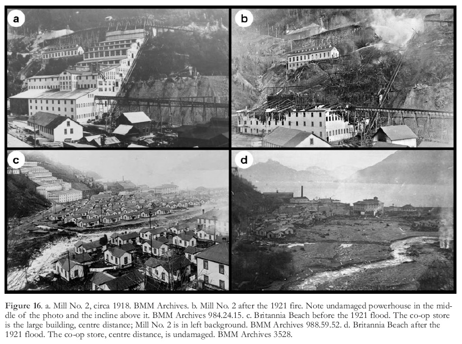 Display large image of Figure 16
65 Elsewhere in BC, mines in the Phoenix and Copper Mountain camps, both major copper producing areas, suspended operations. The copper smelters at Greenwood, Boundary Falls and Grand Forks closed in 1918 and 1919 and, as it turned out, never reopened.
66 In 1921, as the price of copper was bottoming, Britannia was dealt two more serious blows. In March, the concentrator (Mill No. 2), which had been idled by the production cut-back, was destroyed by fire (Fig. 16a, b) and in October a flash flood in Britannia Creek wiped out part of the Beach community, with significant loss of life (Fig. 16c, d) (see section titled Disasters).
67 Production was suspended for the whole of 1922, as every effort was devoted to recovery and rebuilding under Browning’s direction. New family homes were built on a bench well above the level of Britannia Creek and a new concentrator, to be known as No. 3 mill, was constructed adjacent to the previous mill site. A significant improvement to the ore transportation system was completed in 1922, namely a 446 m long ore-pass from near the 2700L portal to the 4100L. Rather than being lowered down the incline, ore carried from the 2200L by the railroad could now be dumped through the 2700L – 4100L ore-pass and trammed on the 4100L haulage-way out to the mill storage bins (Figs. 6, 10).
1923 – 1929
68 Mill No. 3 (Fig. 17), with a rated capacity of 2300 mtpd, was commissioned early in 1923 and production resumed after a year of rebuilding. Although all the ore was now handled through the 2700L – 4100L ore pass, the incline was kept in operation to service the Townsite. The Victoria mine began production in 1923, but the ore travelled a circuitous route that included a short aerial tramway lift to the 1600L portal on the Furry Creek side of Britannia Mountain. However, in 1924 the 2200L adit was extended to the Victoria workings (making it 3 km long), thereby connecting the Victoria mine directly to the ore transportation system. In late 1925 or early 1926 the lower leg of the old aerial tramway that had carried ore to mills 1 and 2, and recently to No. 3 mill, was abandoned.
 Display large image of Figure 17
 Display large image of Figure 18
69 The surface electric railway, the last component of the ore transportation system still above ground, was eliminated from the system in 1928. During the previous two years the 2700L adit had been extended to below the Bluff and Fairview mines (making it 3.4 km long) and near its end it was linked to the 2200L by a major orepass. Ore from all the mines, which had previously been hauled out the 2200L haulageway and down to the 2700L – 4100L orepass near the 2700L portal by the surface railway, was now dumped through the new 2200L – 2700L orepass to near the end of the 2700L (Fig. 6) and then hauled about 3.3 km to a crushing chamber at the top of the 2700L – 4100L ore-pass. There it was crushed, fed down to the 4100L and hauled out to the mill. This improvement reduced costs and production delays related to snow removal on the railway (Fig. 18) and made the 2700L and 4100L adits the two main haulageways. The surface railway and the incline remained in service for transporting supplies and passengers between the Beach and the Townsite.
70 In 1929, the price of copper exceeded 18¢/lb, after being range-bound between 12 and 14¢/lb for 8 years. It was a good year for the mining industry. Approximately 1100 men were employed at Britannia mines, 625 underground and 470 on surface. About half the men on surface worked at the Beach and the remainder worked in the various camps. Most of the underground crew lived at the Town-site, although miners also lived at the Barbara, Empress, Victoria and Incline (2700L) camps.
1930 – 1934: The Great Depression
71 In 1930 ore production at Britannia reached an all-time high of just over two million mt. The Fairview, Bluff, Empress and Victoria mines were all in production. About 20 500 mt of copper and 392 000 grams of gold were recovered. However, towards the end of 1930, Britannia, and the mining industry as a whole, began to be affected by the Great Depression.
72 The economic downturn that followed the Wall Street stock market crash in October 1929 quickly spread throughout the industrialized world. The demand for metals, and metal prices, plummeted. In 1930 the price of copper fell 40% in six months, and continued to fall from an average of 13¢/lb in 1930 to an average of only 5.8¢/lb in 1932. Compounding the price squeeze were protectionist trade barriers erected by Britain and the United States that affected sales of Britannia copper. As a result, production at Britannia fell from over 2 million mt in 1930 to a depression low of 598 000 mt in 1933. Elsewhere in BC, the Copper Mountain mine near Princeton, BC, which was a significant copper producer before the depression, closed in 1930. The Anyox mine, the only other important copper producer still operating in BC, maintained production but became depleted and closed in 1935.
73 The most difficult years of the depression for Britannia were 1932 and 1933. Operations were severely restricted but the mine survived. In 1932 the tonnage mined was 30% of that mined in 1930 and in 1933 the mill operated at only 20% of capacity. By mid 1933 the payroll had dropped to about 400, compared to an average of over 1000 in 1930. In order to minimize layoffs, men were employed in staggered shifts and were allotted a number of days of employment per month, with a degree of preference given to married men. In this way, most men with families, as well as some of the single men, kept their jobs.
74 Britannia adapted during the depression by mining orebodies that contained relatively high gold and zinc credits. Britannia became a copper– gold–zinc producer, and in 1933 the mill added a zinc circuit to produce zinc concentrate. While the price of gold increased from an average of US$20.72 per ounce in 1930 to US$35.00 in 1935, the price of copper decreased. Britannia responded by drawing most of its ore between 1931 and 1936 from the East Bluff orebody, which contained only 0.5% copper but had higher gold and zinc values than other orebodies. Table 3 shows the dramatic decrease in copper and the increases in gold and zinc produced between 1931 and 1937. Metal prices began to recover in 1933, and in 1936 it was decided to resume mining beyond the East Bluff and to increase both mine and mill production. Tables 3 and 4 show these changes and the accompanying changes in employment.
1935 – 1946
75 By 1938 production had recovered from the depression-era lows almost to the peak level of 1930, and the average payroll had increased to pre-depression levels (Table 4). But in 1941 production began to drop sharply to a 23 year low in 1946 of only 400 000 mt (Fig. 11). This large fluctuation was not caused by metal prices, which gradually increased during this period, but from labour issues. Whereas the upswing from 1934 to 1938 reflected a period of increasing employment, active mine development, the beginning of production in 1938 from No. 5 and No. 8 mines, and a high level of continuing production from the Bluff, Fairview and Victoria mines, the decline from 1941 to 1946 reflected a war-time shortage of experienced miners. Table 4 reflects these operational changes.
76 During the post-depression period several important changes were made to the ore transportation system. Extension of the 4100L adit had continued periodically through the depression and by 1938 the face was 4.1 km from the portal. An ore-pass raised from near the end of the 4100L adit to a point on the 2700L near the bottom of the 2200L – 2700L orepass (Fig. 6) provided a more direct route to the 4100L haulageway for all ore handled on and above the 2200L, including ore from the recently discovered No. 5 orebody. A primary crushing station was built near the bottom of the new 2700L – 4100L ore-pass. The 2700L adit was no longer a principal haulageway because ore was no longer hauled from the bottom of the 2200L – 2700L ore-pass to the old 2700L – 4100L ore-pass near the 2700L portal.
77 No. 8 orebody was discovered in 1937 by a diamond drill program along the 4100L. An internal shaft (#8) was collared a short distance west of the new 2700L – 4100L ore-pass to access the No. 8 orebody, most of which lay below the 4100L. By 1941, the 4100L adit had been extended to the Victoria shaft (6.1 km from the portal) and ore from all the mines could now be hauled to the mill on the 4100L. The 4100L had become the only principal haulageway, and it would remain as such to service the yet to be discovered No. 10 Mine. The 4100L adit was subsequently extended beyond the Victoria shaft to approximately 8 km from the portal (Fig. 6).
78 By 1941 the labour shortage attributable to WW II had become serious. Not only had enlistment reduced the workforce during the war but so too had the lure of better paying jobs with companies engaged in the war effort. Few returning veterans had mining experience and few wanted to obtain it. In a single post-war year, Britannia lost 1152 employees, mostly recently hired men who were unqualified or who became dissatisfied. "Britannia was hiring just about anything that walked" (anonymous staff member). New ore was not being developed and production and profits fell. Toward the end of 1945, Britannia was operating with fewer than 400 employees and, in the opinion of one operations staffer, it was "living in a state of hand to mouth". In 1946 the situation was exacerbated by a strike by the Britannia local of the International Union of Mine, Mill and Smelter Workers (Canada) that closed Britannia for 3.5 months. The closure was partly responsible for the drop in production in 1946 to less than 400 000 mt, the lowest level since 1920.
 Display large image of Table 4
79 In 1945 or 1946, the New York office of Howe Sound Co. decided to close Britannia if newly set production quotas could not be met (Ramsey 2004, p. 100). Fortunately, metal prices improved and closure was avoided.
1947 – 1962
80 In 1947 C. P. Browning retired and E. C. Roper was appointed manager. In 1956 G.C. Lipsey was appointed manager and E.C. Roper moved to the New York to become President of BM&S Co. and the Howe Sound Co. Late in 1957, Lipsey retired and J.S. Roper (no relation to E.C. Roper) was appointed temporary manager.
81 With the resumption of work after the 1946 strike, the mine was still under threat of closure, but spurred by a sharp rise in the prices of copper, zinc and lead and an improving labour situation, production more than doubled from 1946 to 1947. During the decade from 1947 to 1957, annual production at Britannia remained fairly constant, between 721 000 and 831 000 mt. Metal prices increased, supported in part by the Korean War (1950 to 1953). During this period most of the ore came from the Bluff, Fairview, No. 8 and Victoria mines. The Jane, East Bluff, Empress and No. 5 mines were active but produced only small tonnages intermittently; in 1954 No. 5 mine was depleted. Development consisted mainly of following downward extensions of known ore-bodies such as the Bluff.
82 Base metal and silver prices fell sharply during 1957 and both 1957 and 1958 were difficult years for the North American mining industry. At Britannia, the payroll at the end of 1957 was 523 compared to 859 the previous year, and production was falling. The Howe Sound Company lost a significant sum of money during 1957, and late in the year it announced that Britannia would close in December, ostensibly because of the low price of copper. However, direct subsidies from the provincial and federal governments enabled Britannia to continue operations on a reduced scale until March, 1958, when operations were temporarily suspended. A mere 60 600 mt of ore were produced and milled in 1958.
83 After a financial reorganization of the Howe Sound Company (see section titled ‘Demise of the Howe Sound Company’) D.W. Pringle was appointed general superintendent, and then manager at Britannia. Underground operations resumed in January 1959, and the mill reopened the following month. Until 1963 total employment ranged between 300 and 400, with 200 to 250 men working underground.
84 Production increased as metal prices improved, reaching slightly over 450 000 mt in 1962. Development work underground returned to a normal level and limited exploration was conducted in the Victoria and No. 8 mines, which suggests that the operations staff expected production to continue. However, the strategy of the reorganized Howe Sound Company was to divest itself of its mining assets. Accordingly, the instructions to A.D. McCutcheon, Britannia operations manager during 1961 and 1962, were to operate the mine as long as it was making money and then to shut it down (Waterman 1970). To this end the Britannia operation was put up for sale.
85 Following an invitation by McCutcheon to J.B. Knaebel, General Manager of Anaconda Canada Ltd., Knaebel visited the mine in 1962. Knaebel and Glen C. Waterman then conducted a formal evaluation of the Britannia operation. Knaebel examined the economics of the operation and Waterman studied the geology and recalculated the ore reserves. The result of their study was a recommendation that Anaconda purchase the Britannia property.
1963 – 1974: The Anaconda Years
86 In January 1963, the Anaconda Company (Canada) Ltd., a wholly-owned subsidiary of Anaconda American Brass Limited, purchased the Britannia operations from the Howe Sound Company for $5 000 000. Britannia was incorporated as Anaconda Britannia Mines Ltd., and B.B. Greenlee was appointed resident manager. Anaconda Canada Ltd. used Britannia as an operations base for exploration activities in western Canada, although it also maintained an office in Vancouver, which became the registered office of Anaconda Canada in 1965.
87 From an operations perspective, Anaconda had a poor start at Britannia. In August, 1964, the Britannia local of the Mine, Mill and Smelter Worker’s Union called a strike, and in September the company removed all equipment from underground except the main hoists and transformers. The strike lasted five months and production did not resume until May, 1965.
88 Anaconda initially developed and mined limited reserves in the No. 8, Victoria and Bluff mines. In 1965, roads were built to the old Jane Basin to access the previously mined ‘glory holes’ (see section titled ‘Mining Methods’) and during the summer of 1967, a 20-man open-pit crew produced about 77 000 mt from the Jane pit (7.5% of the year’s production). By the end of 1971 all the ore zones above the 4100 haulageway level had been mined out, namely the Jane, Bluff, Fairview, Empress, Victoria, No. 4 and No. 5 zones.
89 After assuming control of Britannia, Anaconda established a well equipped geological research laboratory, and a large staff of geologists was employed to re-log existing drill core and to re-map the mine workings. The program also involved considerable diamond drilling, which resulted in the discovery in 1964 of the 040 orebody lying 760 m west of the No. 8 mine.
90 Unlike other orebodies, which lay close to the footwall of the shear zone, the 040 was found some 240 m into the shear zone from the footwall. It was a small orebody, but its discovery led to the development of the important No. 10 mine. A drill hole from the 5700L in No. 8 mine, the deepest level in the mine at the time, had intersected 12 m of 040 mineralization the day before the August, 1964, strike began, and G. C. Waterman, Vice President and Chief Geologist of Anaconda Britannia Mines Ltd., later observed that if the 040 intersection had not been made before the strike began it is probable that the 5700L would not have been reclaimed after the strike, and hence the 040 and No. 10 ore bodies would not have been discovered (Waterman 1970). No. 10 shaft was collared on the 4100L, 2435 m from the portal, and extended to below the 5700 level. Production began in October of 1970, using trackless mining. The No. 10 ore body contained approximately 2.7 million mt grading 1.9% copper, and accounted for about half of Anaconda’s Britannia production.
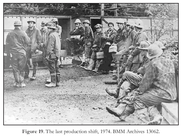
91 During 12 years of operation, Anaconda mined 5.7 million mt and produced 66 700 mt of copper, which was almost 13% of the total copper recovered from Britannia Mines. When Anaconda closed Britannia in 1974, No. 8 ore zone was depleted and the remaining ore reserves in No. 10 Mine, mostly below the 5700L, were about 1.4 million mt grading approximately 1.9% copper (MINFILE), which represented just under three years mill feed at the 1973 production rate. The price of copper was an historic high of 77¢/lb. The last production shift went underground in November of 1974 (Fig. 19).
92 During nearly 70 years of almost continuous operation, Britannia Mines produced 517 000 mt of copper, 125 290 mt of zinc and lesser, but economically important, quantities of gold, silver, lead and cadmium. The network of tunnels, shafts, raises and development drifts connecting the workings extended more than 1.8 km vertically and 7 km horizontally, and is estimated to have exceeded 200 km total length.
Mining Methods
93 Mining methods at Britannia were mainly adaptations of square-set, cutand-fill and shrinkage stoping techniques (Brennan 1935; Stewart 1968). Muck handling during stope development was by scraper drifts and mucking machine draw-points, supplemented by bulldoze chambers in blocky ground. Longhole ring drilling, both horizontal and vertical, was utilized during the 1930s and 1940s in large, wide stopes. Parts of the Bluff and Fairview orebodies were mined by induced caving. At various times, notably from 1916 to 1922, upper parts of the Jane, Fairview and Bluff deposits were mined by a combination of open pits (‘glory holes’) and shrinkage stoping. The glory-hole system of mining was developed by driving raises from underground to the surface; the tops of these raises were then enlarged. Five such open pits were developed (Fig. 10), from which broken ore was directed through ore-passes to the underground ore transportation system. The snow accumulation at high elevations limited open-pit production to about seven months of the year.
94 Ground in the Britannia mines was sufficiently competent that extensive timbering was not required. However, in the Victoria and Empress mines, square-set stoping was required, in places with immediate back-filling. A sawmill was established near the Victoria camp in 1924 to supply the required timber.
95 A significant production advantage at Britannia was that, except for No. 8 and No. 10 orebodies (which lay below the 4100L), and early production from the Victoria mine, the vertical component of ore transportation was largely gravity driven. The No. 8 and No. 10 shafts were sunk from the 4100L and ore was hoisted to the 4100L haulageway. In No. 10 mine, ore was mined by blasthole stoping and sub-level caving with trackless haulage to No. 10 shaft. When mining operations ceased near the end of 1974, the trackless haulage system reached below the 5950L, which was more than 518 m below sea level. Although the bottom of the mine was below sea level it did not extend out beneath Howe Sound.
96 Headframes were not a common feature at Britannia because the mines were developed and serviced through adits and internal shafts, some of which were driven as raises. The Victoria camp was an exception. The Victoria shaft was initially sunk internally from the 1900L but later raised to surface to accommodate a larger hoist for which a headframe was required.
Milling
97 The performance of the Britannia concentrators and the ability of the concentrator staff to modify flow sheets to fit the needs of the day in a timely manner were significant factors in the productivity and longevity of Britannia. Over the years three concentrators, locally referred to as mills Nos. 1, 2 and 3, were built, all located at Britannia Beach.
98 Mill No. 1 was commissioned in 1905 with a capacity of 180 mtpd. It employed a gravity separation circuit consisting of jigs and tables, which was typical for the day. Performance was not up to expectations and the mill was completely redesigned in 1907. However, results were still not satisfactory, mainly because of the fine grained and intimately intergrown nature of the sulphide minerals, which required fine grinding to liberate the chalcopyrite. Gravity separation did not work well on finely ground material, a limitation that was well known, but unavoidable, at the time.
99 The Jane and Bluff mines, which provided most of the mill feed during the early years, contained some relatively high-grade and coarse-grained ore that was hand sorted to produce direct shipping material. Thus, in spite of poor recovery from the concentrator, overall grade of smelter shipments was initially adequate, especially given the rising price of copper. By 1908, however, it became apparent that most of the potential ore consisted of low-grade, fine-grained material that could not be treated satisfactorily by gravity separation.
100 Fortunately, the process of mineral separation by froth flotation was being developed at the time. Experiments with Elmore vacuum flotation cells, which employed a vacuum rather than the introduction of air to produce froth, began at Britannia in 1909 or 1910. The Elmore vacuum process had been tried in 1903 at the Le Roi Mine in Rossland, BC, but was abandoned. A unit at Britannia with a capacity of 30 mtpd reportedly performed well (AR-BCMM 1911), but the process was not adopted because large quantities of oil reagent were required.
101 A successful mineral flotation process that incorporated the introduction of air into a mineral slurry and agitation to produce froth was patented by Mineral Separation Ltd. of England in 1905. The first successful industrial-scale application of froth flotation was at Broken Hill, Australia, in 1905 for the recovery of fine-grained sphalerite from gravity separation tailings. The first successful application in the United States was in 1907, again for the recovery of sphalerite, but by 1910 the process had not yet been widely adopted. Experiments with froth flotation were conducted at Britannia’s Mill No. 1 in 1911, and in 1912 Mineral Separation-type froth flotation cells were installed to treat table tailings. This was the first successful application of froth flotation in BC (Djingheuzian 1957), and possibly in Canada. However, it was not until about 1924 that froth flotation was adopted as the primary method of concentration at Britannia. Experimentation into different aspects of froth flotation continued at Britannia, one result being the development of ‘deep-air flotation’ cells (McLeod 1938).
102 In hindsight, the successful adoption of froth flotation by Britannia in 1912 was highly significant, for without the ability to produce a satisfactory concentrate by gravity separation alone the mine would very likely have closed, and development of the deposit would have been postponed for years. Froth flotation made Britannia’s large, low-grade and fine-grained orebodies economical to mine, and allowed Britannia Mines to increase production and take advantage of the then increasing price of copper leading up to WW I.
103 After the recovery problem was remedied, Mill No. 1 was expanded to about 725 mtpd, and for several years after Mill No. 2 was built, the two mills operated in conjunction. Mill No. 1 was dismantled in 1919 (J. Iverson, personal communication).
104 Mill No. 2 was constructed in two stages. The first unit, with a nominal capacity of 900 mtpd, was commissioned in December, 1915 and the second unit, with the same capacity, began operation in 1916. Flotation was an important component of Mill No. 2, but was still used only to treat tailings from jigs. The mill was soon operating above its rated capacity, and together mills 1 and 2 provided a milling capacity of over 2700 mtpd. Mill production (ore milled) jumped from approximately 193 200 mt in 1915 to almost 600 550 mt in 1917. Mill No. 2 was a multi-level, timber structure (Fig. 16a). Its hillside location enabled the design to take advantage of gravity to assist in transporting ore from one stage of the milling process to another, hence its designation as a ‘gravity-fed’ mill. Mill feed was delivered by the electric railway and the incline, which had been put into operation in 1915. After only five years of operation, Mill No. 2 was completely destroyed by fire in 1921. Plans for Mill No. 3 were begun immediately.
105 Mill No. 3 (Fig. 17), the shell of which stands today, was commissioned in February 1923, with a capacity of 2300 mtpd. During the following 15 years the capacity was increased in stages, and during Britannia’s peak years of production in the late 1930s it operated at 5500 mtpd. It is an imposing eight-storey, 70-m high steel and concrete structure built with its foundations anchored in bedrock on the steep hillside beside the former location of Mill No. 2. Each floor is offset into the hillside from the level below in the fashion of a giant stairway. Like Mill No. 2, the design utilized gravity to pass mill feed from the ore delivery and grinding levels on the top floors down through successive stages of concentration on lower floors. Froth flotation was the primary means of concentration in Mill No. 3, although initially the primary concentration was achieved by a gravity circuit, and flotation was used to clean the gravity tailings.
106 In contrast to mills 1 and 2, which produced a bulk flotation concentrate that contained worthless pyrite as well as sphalerite and chalcopyrite, Mill No. 3 incorporated the recently developed process of differential flotation, by which pyrite was not floated with chalcopyrite but was discarded with the tailings (Pearse 1927). A market was found for the hitherto worthless pyrite in 1927, and the flotation circuit was modified to recover a clean pyrite concentrate from the tailings that contained 49.8% sulphur. A pyrite concentrate continued to be collected in most years until 1963. It was initially shipped to Japan as a source of iron, but most of it was marketed in North America for the production of sulphuric acid. The total production of pyrite over these 36 years amounted to approximately one million mt.
107 An ore-washing plant was installed in 1927 at the millhead to improve copper recovery by collecting ‘slimes’, which contained partially oxidized particles of ore minerals that required special preparation for flotation. The same year a blanket system for the recovery of free gold from tailings was installed. The mill began producing a galena concentrate by differential flotation in 1928, and during the depression years of 1933 through 1936, and again from 1947 to 1971, a sphalerite concentrate was produced, from which a minor amount of cadmium was recovered. The original Mineral Separation-type flotation cells were replaced by Forrester-type cells prior to 1927 and deep-air flotation cells were installed in 1940. Milling innovations and modifications such as these helped Britannia Mines maximize profitability during fluctuations in mineral prices, especially during the depression years.
108 In reference to Britannia’s gravity-fed Mill No. 3, 46 years after it was built, the Director of Mining Research for Anaconda stated "Although this design would not be used today because of high construction costs and inefficient use of labour and supervision on the many operating levels, the metallurgical efficiency of the plant is good, even by modern standards." (Stewart 1968, p. 16).
Other Operational Features
109 Other features of Britannia mines are worth a brief mention because they illustrate the focus on economy and efficiency that was characteristic in all aspects of the operation. Clothier (1927) noted in the 1927 AR-BCMM "an engineer cannot help being forcibly impressed by the well planned system for efficiency in every department and the consequent economical production. Even the proverbial ‘squeal’ is saved in the concentrator."
Crofton Smelter and Quadra Steamship Company
110 During the early years of operation, Britannia shipped its mill concentrates to the Crofton smelter, which was located on Vancouver Island about 95 km by water from Britannia. The smelter had been purchased by a sister company, the Britannia Smelting Company, in 1905. When the assets of all the companies associated with the Britannia operation were amalgamated in 1908, ownership of the smelter was the reason for including the term ‘Smelting’ in the Britannia Mining and Smelting Company name.
111 The Crofton smelter was closed in 1911, and thereafter Britannia shipped its concentrates to the larger Tacoma smelter in Washington, which was owned by ASARCO. The initial contract for shipping concentrates to Tacoma expired in 1916, and the new shipping rates were considered by Britannia to be unreasonable. Consequently, in 1916, the Quadra Steamship Company was formed as a wholly-owned subsidiary of Britannia Mining and Smelting Co. to transport concentrates to Tacoma. Two old coastal steamers, the Canadian Government survey ship Quadra (Fig. 20) and the Canadian Pacific Steamship Company’s original Princess Louise (a paddle wheeler stripped down to serve as a barge), were purchased, and these vessels carried concentrates to Tacoma for nearly six years. After the Quadra was sold in 1924 she served as a rum runner (Ramsey 2004).
Britannia Power Co. Ltd.
112 By 1905, and possibly by 1904, the Jane and the Beach camps were receiving power from Pelton wheel-driven hydroelectric generators installed on Britannia Creek. In 1905, the Britannia Power Co. Ltd. was formed to own and operate a recently completed hydro power dam on Britannia Creek and to hold water right licenses on Britannia and South Valley creeks (South Valley Creek has since been renamed Furry Creek). By 1922, powerhouses had been built at the Townsite and the Beach to house hydroelectric generators powered by water from five storage dams in the Britannia Creek water-shed and one on Furry Creek. Additional power for emergency situations was available from a steam plant located at the Beach. Nevertheless, it was apparent that future operations could be hampered by periods of low precipitation. Consequently, BM&S Co. contracted for additional power from the British Columbia Electric Railway Company’s plant in North Vancouver, and a 48 km transmission line to the Beach was completed in 1923. In 1968 the original hydroelectric system was still providing 52% of the power requirements. A 1968 Anaconda review of Britannia’s history stated that "Britannia is unique in that it is one of the few remaining mine plants in the world that still maintains its own hydroelectric system".
Foundry
113 A foundry, based on an electric furnace designed by mill superintendent A.C. Monro, was constructed at the Beach in 1928 for the purpose of producing various castings required for both the mine and the mill. Scrap metal and used rails provided the metal to produce linings and balls for the ball mills and parts for rock crushers and ore chutes (Hatch 1957). For example, in 1955 the foundry produced 1000 mt of grinding balls and 300 mt of other items.
Copper Precipitation Plants
114 For 49 years BM&S Co. and Anaconda recovered copper from acidic, copper-bearing waters that drained from the mine, mostly from the 2200L and 4100L portals. The mine waters originated as surface runoff from heavy rain and snowmelt that seeped into areas underlain by fractured and weakly mineralized rock adjacent to ‘glory holes’ and areas of subsidence above old stopes. The resulting oxidation of sulphides produced the metal bearing acid mine drainage (Ebbutt and Selnes 1928). In places the oxidized zone was over 60 m deep. Miners who worked in wet sections of the mine could attest to the acidity and copper content of the waters, for after 4 to 6 weeks of working in such areas woolen long-johns would become green and brittle from adsorbed copper. Eventually they would simply disintegrate (personal experience).
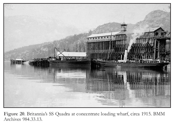 Display large image of Figure 20
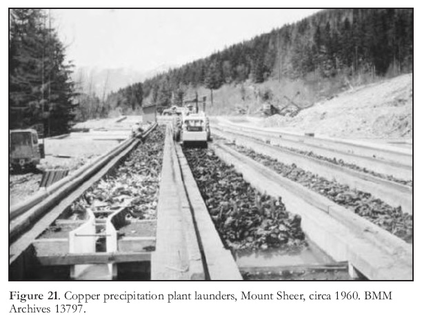 Display large image of Figure 21
115 The copper recovery process was based on the galvanic principal, whereby copper contained in an acidic solution will replace metallic iron and tin. The first ‘precipitation plant’, as the system was called, was built underground on the 1200L in 1925 (Ebbutt and Selnes 1928). The basic design consisted of wooden launders (box-like troughs; Fig. 21) within which the flow of mine water over shredded scrap tin cans suspended on gratings was controlled by partitions and baffles. Iron and tin were taken into solution and copper was precipitated and accumulated as sludge on the bottom of the launders. The sludge was removed, dried, bagged and shipped to the Tacoma smelter. The total length of launders in the first plant was 273 m. In 1926, the first year for which smelter returns were recorded for the precipitation plant, 90.7 mt of copper were recovered and in 1927 a modified and enlarged plant produced 226.8 mt of copper, or 1.5% of Britannia’s copper production for that year. Larger and improved precipitation plants were built on surface near the 2200L portal, and in 1956 a plant was built at the Beach to process waters emanating from the 4100L (Hatch 1957). The Beach plant featured five concrete launders, each 91.4 m long. The precipitation plants normally produced about 1% of the copper produced in a year, although in the depression year of 1933 it was about 6% and in 1967 it was 4.8%. The precipitation plants required only a few men per shift and little equipment to operate them, so the cost/lb of copper recovered was considerably less than for copper recovered from ore. These mine waters were, of course, the source of the acid mine drainage problem at Britannia after the mine closed.
DISASTERS
116 For over fifty years Britannia was not connected by road or rail to the ‘outside’. When emergency help was needed from other communities, it was slow in arriving. Services that are taken for granted today, such as helicopter med-evac and social assistance for communities dealing with disasters, were nonexistent. In order to carry on after a disaster, the members of communities such as Britannia had, by necessity, to be self sufficient, resilient and stoic.
1915 Slide
117 On March 22, 1915, at 12:03 am the Jane Camp was hit by a debris avalanche of snow, mud and rock. Fifty seven men, women and children were killed and 22 were injured (Fig. 13). Many homes and mine buildings, including the tramway loading terminus, were destroyed . The slide broke the Jane Camp phone line, so the first indication of trouble was a sudden decrease of the power load on the generators at the Tunnel Camp power-house. Because the slide had disabled the tramway, rescuers leaving the Tunnel Camp had to hike to the Jane Camp, a climb of approximately 335 m vertically. Phone calls from Britannia Beach eventually summoned help by steamer from Vancouver and by evening of the following day injured survivors began to arrive in Vancouver. The disaster caused a three-month suspension of production and resulted in the closure of the Jane Camp.
Spanish Flu Pandemic
118 The 1918 Spanish flu pandemic took a larger toll of Britannia lives than the two World Wars combined. The record of flu deaths at Britannia is not available, but it is estimated that over 40 residents lost their lives, including the mine manager’s daughter, who was attending school in Vancouver.
119 Activity apparently came to a standstill for a matter of weeks. Ramsey (2004, p. 51) reported that "Men died like flies in the bunkhouses, and the dance hall up at the Tunnel Camp became a temporary hospital". The medical officer at the Beach was overwhelmed; the hospital was full, every house had somebody sick in it, and his task was made even more difficult when the Tunnel Camp nurse succumbed to the flu. In his 1918 annual report the mine manager, E. J. Donohue, succinctly states, "In conclusion I would add that our operation was seriously interfered with during the months of October and November on account of the Spanish influenza epidemic" (Donohue 1919).
Fire and Flood
120 In March of 1921, while Mill No. 2 was idled by the low price of copper, it burned to the ground (Fig. 16a, b). Fortunately no lives were lost. Plans for construction of a new mill began immediately. The event must have been a bitter pill for management, given the difficult economic situation for the mining industry at the time. But yet another disaster was to befall the community that year.
121 On Sunday, October 28, 1921, shortly after 9 pm, a log and debris obstruction on the upper reaches of Britannia Creek broke, and when the ensuing flood struck the Beach community, 37 were killed and 15 hospitalized as homes and people were swept out to sea (Fig. 16c, d). Weather was a factor, as it was with the debris avalanche of 1915. Heavy rain, which had caused flooding in other lower mainland communities, was responsible for the logjam and buildup of water.
122 The manager’s house at the Beach was turned into a makeshift hospital, because the community hospital was on the other side of the raging creek and therefore inaccessible. The community doctor had only bandages and disinfectant obtained from the company store to treat the injured because medical supplies were in the hospital. Moreover, there was no lighting because the power line was down. The storm had disabled the telephone line to Vancouver, so two men were sent in a rowboat to get word out. They had to row approximately 29 km before finding a functioning phone. At dawn the following day another rowboat was sent to a pulp mill on the other side of Howe Sound and a few hours later the mill’s tugboat arrived with a doctor and some medical supplies. Medical assistance arrived from Vancouver by steamer about noon the day after the flood, and late that afternoon the seriously injured were transported to hospital. Dr. Menzies, the company doctor, who had arrived at the mine only three weeks before (the assignment was his first practice after medical school) described the scene the next morning as follows: "Our village was a mass of wreckage with some wide-open spaces where houses had been washed out. Some of the buildings had been thrust aside and lay at crazy angles where they had been deposited; others had been crushed to pieces and were now merely bits of lumber mingled with the numerous logs that had been brought down by the flood" (Menzies 1959).
COMMUNITIES AND CAMPS
123 Britannia operations were conducted, at differing times, from the Jane Camp, Tunnel Camp, Britannia Beach, and from a number of satellite ‘camps’. Some of the satellite camps operated for a number of years, but until 1915 the principal mine camp was the Jane Camp, after which it was the Tunnel Camp (later known as the Townsite and Mount Sheer; Fig. 22a). Most of the miners lived in the Tunnel Camp and most of the mine support shops were located there. Britannia Beach (Fig. 22b) was the administration centre and the site of the concentrators and shipping facilities (Figs. 17, 20).
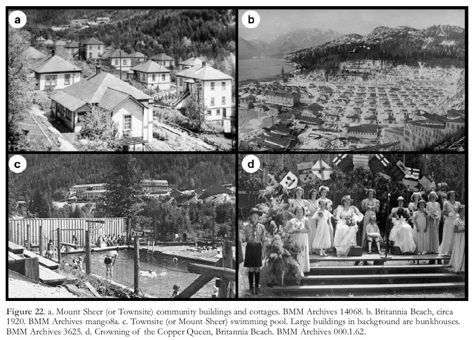 Display large image of Figure 22
124 Until completion of the road from Squamish in 1949, the railroad from Vancouver in 1956, and the road from Vancouver in 1957, the Britannia communities were true ‘company towns’. They were located on company owned land and the only employment available was with the company or with establishments such as banks that operated only with company permission. Although the control exercised by Britannia management may have been deemed excessive and paternalistic by some, as it was in most company towns, it appears that the well-being of workers and their families were important concerns of management, and that this attitude was supported by the parent Howe Sound Company.
125 In addition to housing, for which the standard monthly rent was $1.00 per room, employee amenities provided by the company at both the Beach and the Townsite included schools, free medical and dental care, well stocked stores and recreational facilities. Besides groceries, the Beach store stocked a full line of dry goods that included fashionable clothing, furniture, and silver and china table settings. The company stores became dividend-paying co-operative mercantile stores in 1922. The Beach had a hospital staffed by a nurse in 1913 and as early as 1916 the Tunnel Camp hospital contained an operating room, a 3-bed ward, a dispensary and nurses quarters. In 1926, a company-paid group insurance plan for all employees was inaugurated. Community centres at the Beach and the Townsite featured a dance hall, reading room, pool room, movie theatre and gymnasium, and each community had a swimming pool (Fig. 22c), tennis court, roller rink and playing fields. Facilities and housing were frequently updated and expanded.
126 Community activities included church groups, clubs (the drama society was popular), and events such as the May Day celebrations, the annual crowning of the ‘Copper Queen’ (Fig. 22d) and baseball tournaments. Residents and teams from the Townsite would ride down the railway and Incline (Fig. 23) to participate in Beach events and the reverse would occur when the Townsite staged events.
127 Winter snow accumulation, which was often several metres thick at the Townsite and at other camps in the mountains (e.g. Fig. 18), affected mine operations and community life alike. The mode and ease of transportation between the communities was a significant aspect of day-to-day life for some.
128 Workers at Britannia hailed from many nations, including Japan and China. In 1900 the Government of Canada enacted Bill No. 47, which barred Japanese and Chinese people from working underground in coal and metalliferous mines. Nevertheless, many Japanese and some Chinese held surface jobs at Britannia. During John Moodie’s tenure as manager, signage on the surface electric railroad was bilingual – English and Japanese (Ramsey 2004, p. 116). Both Caucasian and oriental families lived in cottages provided by the company, but prior to WW II cottages occupied by orientals were on one side of the residential area in both the Beach and the Townsite. At some of the satellite camps, separate bunkhouses and dining rooms were provided for oriental workers, and at the Beach, a separate recreational hall was built for oriental residents. Notwithstanding, oriental workers were an important component of the work-force, and in the communities good friendships were made across racial lines, especially among children. After the 1941 attack on Pearl Harbour, Japanese nationals and Japanese Canadians alike were forced by the Canadian Government to move from the BC coast for reasons of perceived national security.
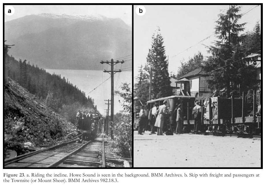 Display large image of Figure 23
Jane Camp
129 The Jane Camp, the original mining site (Figs. 9b, 13a), was located at an elevation of about 1000 m, 4.5 km inland from Britannia Beach. During the first few years of development the only access to the Jane Camp was by a 6.5 km horse trail from Howe Sound. A small steamer from Vancouver made two stops a week at a floating dock at the end of the horse trail. Supplies and equipment for the camp, and for constructing the tramway, were carried by pack-train (Fig. 24). After the aerial tramway that carried ore to the concentrator at Britannia Beach was completed in 1905 (Fig. 12a), supplies for the Jane Camp were carried on the tramway, but for safety’s sake only the company doctor and management personnel were allowed to ride the buckets. Other employees and families going to Vancouver had to hike the horse trail.
130 As mining progressed, the camp grew to include bunkhouses for single men, cabins for families, a store, recreational facilities and various mine buildings. One of the mine buildings was a ‘Candle House’. During the early years, miners at the Jane Mine worked by candlelight or by oil wick lamps (Fig. 12c). Carbide lamps began to be used in the mining industry only in the first decade of the 20 th century. In 1911, Britannia employed 145 men underground (Robertson 1912) and all of these, plus probably a third of the 180 men employed on surface, would have lived in the Jane Camp. After the disastrous debris avalanche in 1915 the Jane Camp was abandoned.
Halfway Camp
131 The Halfway Camp (Fig. 12d) was built in 1904 or 1905 at the bottom of the top leg of the aerial tramway to house workers who operated and maintained the angle station. The lower leg of the tramway followed a different direction than the top leg, and the angle station was where ore carried by the top leg was dumped into bins and reloaded into buckets on the lower leg. After the top leg of the tramway was destroyed, the Halfway Camp was vacated.
Britannia Beach
132 Britannia Beach (Fig. 22b) was the principal, although not the largest, community throughout the life of the mine and it is the only community that remained after the mine closed. Its population was less than the Townsite, but it was the site of the dock for the coastal steamers that linked Britannia to Vancouver and Squamish (Fig. 25) and the location of the concentrators, concentrate-shipping wharf (Fig. 20), mine office and manager’s house. It also had a powerhouse and some mine support shops, such as the assay office and the foundry.
133 Clearing and construction of the Beach Camp began in 1903 and by 1905, the year the mine began shipping concentrates, most of the above-mentioned facilities had been built. In 1905 the Beach also contained accommodation for company officers, a store, a company run hotel and a small number of family cottages. A post office opened in 1907, and in 1915 a telegraph office was established.
134 Minaty Bay was a small shoreline community on BM&S land several kilometres south of the Beach. It was established about 1925 and was not considered to be a separate ‘camp’. Its residents were completely dependent on the facilities provided at Britannia Beach.
The Townsite (Tunnel Camp, Mount Sheer)
135 The Townsite was located on Britannia Creek, in mountainous surroundings, 3.7 km east of the Beach at an elevation of 650 m (Fig. 22a). When it was established in 1914 it was designated the Tunnel Camp (Fig. 14a), in reference to its proximity to the 2200L portal. About 1918, it became known as the Townsite, and when it acquired a post office in 1954 it was officially renamed Mount Sheer. For much of Britannia’s operational life this community was where most of the underground workers and mine staff lived. For example, in 1930, the year of Britannia’s peak production, approximately 1100 men were employed overall, including 625 underground, 245 on surface at the various camps, and only 225 at the Beach. The Townsite contained mine offices and shops, a powerhouse, bunkhouses, apartments for single staff, and numerous cottages for men with families. The community facilities mirrored those at the Beach.
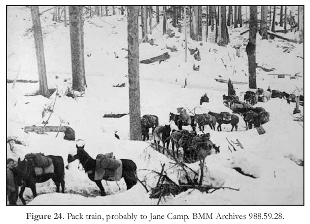 Display large image of Figure 24
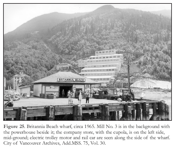 Display large image of Figure 25
136 Before a road between the Beach and the Townsite was completed in 1952, the electric railway (known as the ‘Skip’; Figs. 18, 23b), the incline (Figs. 15a, 23a), and the 347 steps from the Beach to the bottom of the incline were the only means of travel between the two communities. The Britannia high school was located at the Town-site, so students from the Beach had to make the 45 minute trip twice a day. After the communities were linked by road, students attended school in Squamish. The Incline and the Skip were integral components of life at Britannia, and although the ride was a nuisance to some, it was an experience that was remembered.
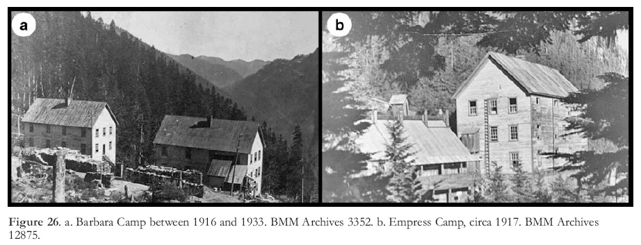 Display large image of Figure 26
137 When Mount Sheer was abandoned in 1974, Anaconda burned the buildings to avoid potential problems with trespassers.
Temporary Camps
138 Temporary ‘camps’, such as Barbara (Fig. 26a), Empress (Fig. 26b), Beta, Victoria and Fairwest, were established during Britannia’s early decades to facilitate the development of deposits located in rugged terrain southeast of the Townsite (Fig. 10). Most of these camps contained bunkhouses and facilities for 40 to 80 single men. Access was through mine workings or by trail.
139 Ramsey (2004, p. 137) relates the humorous story of a resident of the Victoria camp who cut a nice Christmas tree to take home on his holiday visit to Vancouver. The task involved carrying the tree into the mine, up the Victoria shaft, through the mine to the 2200L portal (a trip of 2.7 km), onto the Skip, down the incline and 347 steps to the Beach, onto the boat to Vancouver (all the while protecting it from damage), onto a streetcar in Vancouver, a transfer onto another streetcar and finally proudly presenting it to his wife who commented that it was not much of a tree. The tree was burned.
140 The Barbara, Empress and Beta camps were established in 1916 and 1917 and were closed in the early 1930s. The Victoria Camp was established in 1921 on the Furry Creek side of Britannia Mountain, to facilitate development of the Victoria deposit, and operated until 1943. It initially held 65 men but in 1924 it held 250 underground and surface employees, some of whom lived in family cabins. A sawmill that supplied mine timbers was located at the Victoria Camp. The Fairwest Camp (Fig. 6) was established in 1925 on the south side of Furry Creek to explore the promising Fair-west ore zone. A shaft was sunk but results were disappointing and the camp was closed. The Daisy Camp (Figs, 6, 10) was located on Britannia Mountain 2.3 km east of the Beach to explore the Daisy showing. An adit was driven but the project was abandoned. The Incline Camp was established in 1914 near the top of the incline to house men working on the incline and was later rebuilt for miners working on the extension of the 2700L adit.
DEMISE OF THE HOWE SOUND COMPANY
141 In 1917 Grant B. Schley, the president of Britania’s parent Howe Sound Company, passed away in New York. Throughout his presidency, Schley had given steady support to the Britannia operation. He was succeeded as president by his son Evander B. Schley, who passed away in 1952. A third generation Schley, Reeve Schley, who had been vice president of Howe Sound for some years, succeeded Evander Schley. During the tenures of Grant Schley and Evander Schley, Howe Sound became a successful indirect owner of a number of mines, including the Holden copper mine in Washington (Chelan Copper Mining Co.), the Blackbird cobalt mine in Idaho (Calera Mining Co.) the Snow Lake gold mine in Manitoba (Howe Sound Exploration Co.) and mines in Mexico. In 1949, the operating revenues of Howe Sound were over 19 million US$ and the total income was almost 3 million US$. Britannia Mining and Smelting Company was its premier asset. However, in 1957 Howe Sound lost nearly 10 million US$ due to falling metal prices and was forced to restructure. In 1958, it merged with Haile Mines Inc., a producer of tungsten concentrates and metallurgical grade manganese from mines in Nevada and North Carolina. A new company was incorporated in Delaware with the old name of Howe Sound Company (Howmet Corporation 2010).
142 The president of the new Howe Sound Company was William M. Weaver, Jr., the former president of Haile Mines. Weaver’s strategy was to transform the new Howe Sound Company from a mining to a manufacturing company. He reportedly told a New York Times reporter that "manufacturing is not as risky as mining". The new Howe Sound Company liquidated the Britannia Mining and Smelting Company and assumed direct ownership of Britannia Mines. The Britannia operation was put up for sale, along with the other mining ventures, and by 1962 less than 5% of the new Howe Sound Company’s revenue was from mining.
143 After the legalities of liquidation had been completed, the Britannia Mining and Smelting Company was struck off the BC Registry of Companies in 1964. The new Howe Sound Company’s name was changed to Howmet Corporation in 1965, and in 1970 the company became a subsidiary of the French aluminum company Pechiney (Howmet Corporation 2010).
PRINCIPAL PLAYERS IN THE BRITANNIA STORY
144 Major reasons that Britannia survived its early years of development and production and then continued to produce for decades were because its parent company, the Howe Sound Company, was financially well managed and because the Britannia operation was overseen by a succession of highly competent managers, mine superintendents and mill superintendents. The following paragraphs offer brief biographical sketches of some of the men who played important roles in the Britannia story.
Alexander Forbes
145 By popular legend, Alexander A. Forbes (Fig. 27) is credited with discovering mineralization in the area that was to become Britannia Mines. Forbes was born in Scotland about 1850. At the age of 13 he joined the British navy and after 10 years of service he left to live in Connecticut. There he became a school teacher, married, and obtained medical training. In 1886 he arrived in Vancouver and became a medical officer assigned to the Howe Sound area and the east coast of the Straits of Georgia. He built a cottage in what is now Hopkins Landing and it was there that he met the fisherman Granger who led him to Britannia Mountain. About 1900 he returned to the United States, then re-entered BC in 1912 and became a medical officer for the Powell River Company, which operated a pulp mill 120 km northwest of Vancouver. After about 20 years he retired to North Vancouver and died there in 1935, at age 85. Although his vocation was medicine, his serious avocation was prospecting. He was also, obviously, an adventurer and possibly somewhat of a free spirit.
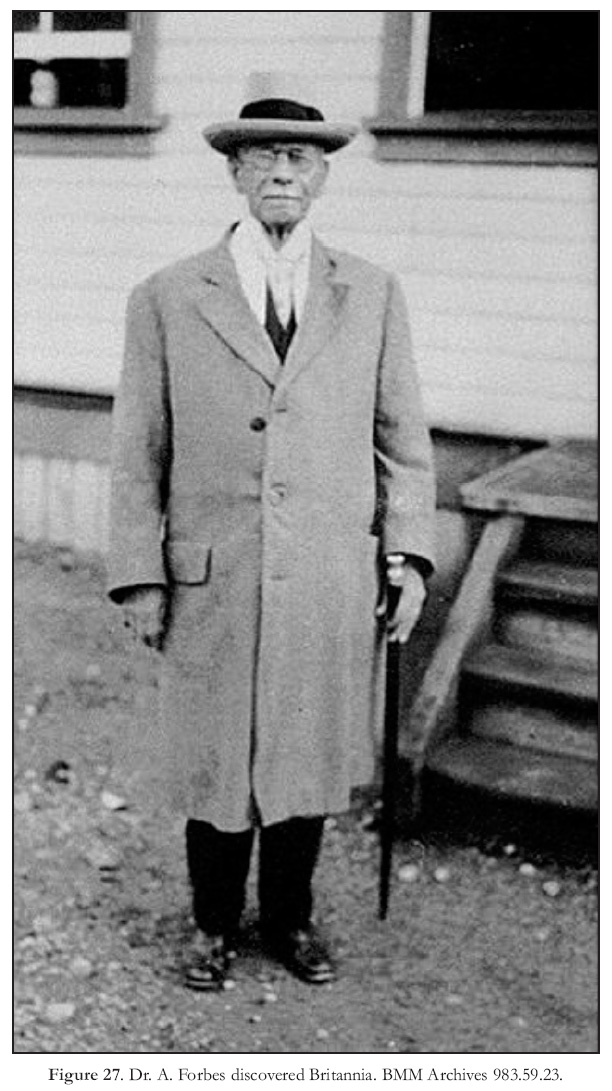 Display large image of Figure 27
Oliver Furry
146 Furry was born about 1855. He became a trapper and owned a cabin on McNab Creek on the west shore of Howe Sound. In 1898, acting as agent for members of the Boskowitz family and others, he staked two groups of claims on Britannia Mountain. It is not known whether Furry discovered copper-stained outcrops where he staked the claims or whether he was given directions to the site. Remarkably, the claims he staked covered all the deposits mined by Britannia Mines. For his efforts he retained part ownership in the claims. The extent of his ownership became the subject of a court case that was carried to the Supreme Court of Canada, where the case was decided in his favour. After staking the Britannia claims, Furry fell into poor physical and mental health, and in 1905, the year that Britannia began production, he entered the Essondale facility for the mentally ill in New Westminster and died there before year end, at the age of 50. Furry Creek, on the south side of Britannia Mountain, is named after him.
Thomas T. Turner and Leo Boskowitz
147 Thomas Turner and the Boskowitz family played brief but crucial roles in the history of Britannia. Turner enlisted Furry to stake the Britannia and Empress claim groups. The Boskowitz family acquired a controlling interest in the claims and financed the initial work on them. It is not known whether Turner was given a map by Forbes that showed the location of mineralization on Britannia Mountain and then engaged Furry, or whether Furry, having seen mineralized outcrops, approached Turner.
148 Turner and the Boskowitz family were furriers, Turner in Vancouver and the Boskowitzes in Victoria. Joseph Boskowitz was a successful businessman with various interests other than mining. His son Leopold became involved with Turner and Furry with regard to claim-staking, and acted as an intermediary for other members of the family.
Howard Walters
149 In 1899 Walters came to Vancouver and Britannia from Montana, where he had been involved in mining. He purchased a 70% interest in the Britannia property from the Boscowitz family and then raised exploration capital from Vancouver sources by forming the Britannia Copper Syndicate. Until 1904 he directed surface and underground development on the Jane and Clifton claims. Walters also acquired water rights on Britannia Creek for the Britannia Copper Syndicate and 75 acres of land at the mouth of Britannia Creek, where the Beach Camp would be built.
George H. Robinson
150 Robinson (Fig. 28a), who hailed from Ohio, came west as an engineer employed on the construction of the Santa Fé Railroad in 1878. He settled in Leadville, Colorado, and prior to becoming associated with the Britannia Copper Syndicate he had a successful career as a mining engineer with a number of mining companies in Montana and Utah. In Utah he was involved in the organization of the Tintic Company, of which G. B. Schley became president (O’Brien 1987). Robinson acquired a controlling interest in the underfinanced Britannia Copper Syndicate in 1901. He reorganized and refinanced the syndicate and was the on-site manager who brought Britannia into production. Sadly, he did not live to see the mine flourish, for he passed away in 1906, in New York City, when he was about 58 years old.
Henry Stern
151 Stern was a New York financier who provided Robinson and the Britannia Copper Syndicate with a window to major financing through his association with Grant B. Schley. Stern incorporated the Howe Sound Company and Schley invested in it. Schley’s investment enabled Howe Sound to purchase a large part of a share offering by the Britannia Copper Syndicate, which in turn provided the Copper Syndicate with funds to pursue development at Britannia. Prior to his involvement with the Howe Sound Company Stern was associated with Schley in mining ventures in Utah.
Grant Barney Schley
152 G. B. Schley (Fig. 28b) was a New York banker and financier who provided the financing to bring Britannia into production. He was a founding partner in the brokerage house of Moore and Schley. Schley was active on the floor of the New York Stock Exchange for many years, and his clients included some of the wealthiest men in the country. Schley became president of a number of mining companies, including the Howe Sound Company, and he was a director of corporations such as the American Smelting and Refining Company (ASARCO), the Northern Pacific Railway Company and the Pittsburgh Coal Company. He was also president of the Tintic Company (O’Brien 1987), which owned subsidiaries in Utah with which Stern, Robinson and Moodie were associated.
153 Schley was born in 1845 near Syracuse, NY, to a farm family of humble circumstances. He obtained only an elementary school education and at the age of 16 he went to work as a peach picker and shipping clerk. Schley’s facility with numbers caught the attention of his employer who, in 1866, transferred him to New York. There he also caught the attention of George F. Baker, president of the First National Bank of New York. Baker invited Schley to join the bank. Grant wooed his boss’s sister, Elizabeth Baker, and the two were married in 1879. G.B. Schley, who was a noted philanthropist, died in 1917, leaving an estate of almost $6 million (O’Brien 1987).
Evander B. Schley
154 Evander Schley was born in 1883, the youngest son of Grant B. Schley. He assumed the presidency of the Howe Sound Company in 1918, after his father’s death. His competent guidance of the Howe Sound Company and his support of the Britannia operation were important factors in the continuing success of Britannia. Under his leadership the Howe Sound Company became the holding company of a number of mining companies. Evander Schley died in 1952.
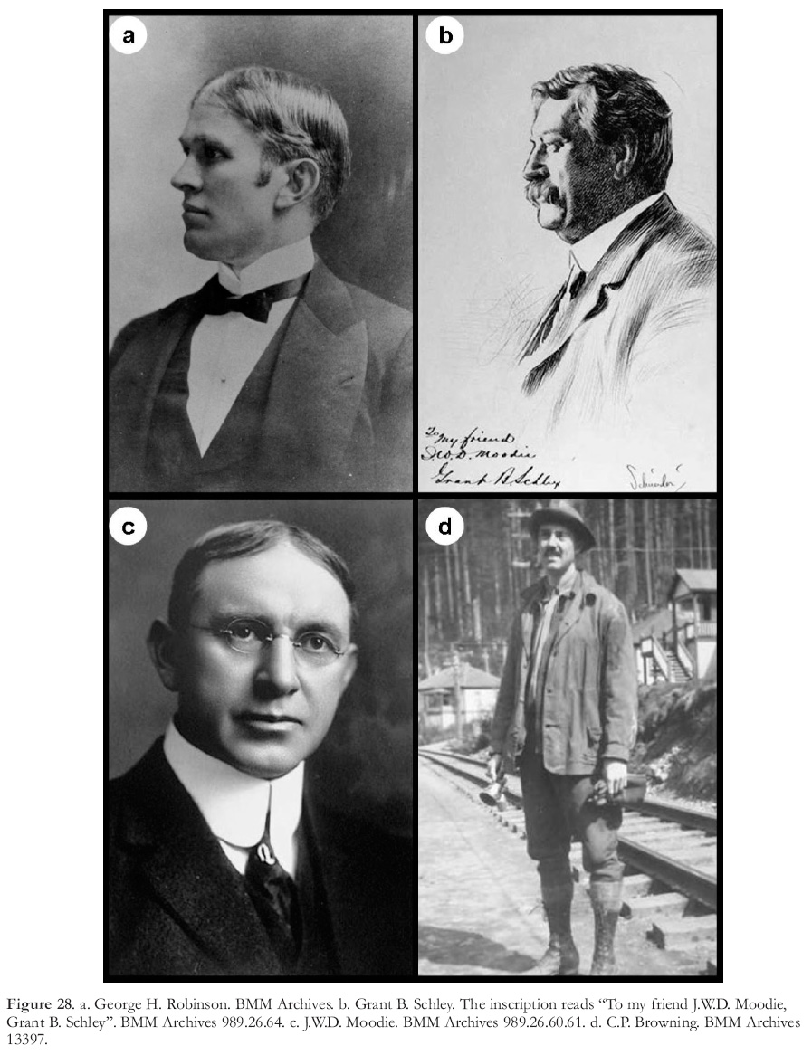 Display large image of Figure 28
Robert H. Leach
155 Leach was born in Massachusetts in 1878 and immigrated to Canada with his wife and three daughters in 1906. When the BM&S Co. was formed in 1908 he became Vice President and on-site manager. Late in 1911 he retired for health reasons and returned to the US, where he died in 1963. Although he served as manager for only 3 or 4 years, Leach oversaw several highly significant developments that enabled the young Britannia mine to survive some serious start-up problems. During his tenure the Britannia mill began trials with mineral flotation methods that led to the adoption of froth flotation to concentrate chalcopyrite, a move that allowed Britannia to economically process the Britannia ore. Also under Leach’s direction, a large tonnage of relatively high-grade ore more amenable to concentration than the previously mined Jane ore, was outlined at the Fairview ore zone. These events set the stage for his successor, J.W.D. Moodie.
John Weddeburn Dunbar Moodie
156 J.W.D. Moodie (Fig. 28c) became manager in November, 1911, and held the position for nine years. He was born in Hamilton, ON, became a mining engineer and was the first Canadian manager at Britannia. Before coming to Britannia, Moodie had been manager of a project in Utah that was controlled by the Tintic Company with which Grant Schley was associated (AR-BCMM 1911). Moodie was demanding but competent, and highly thought of in the New York office of the Howe Sound Company. When he was appointed manager of Britannia he was given the authority to embark on a $5 million development program that would position Britannia to become a major world copper producer. The establishment of the 2200L as a main haulageway, the planning of the Tunnel Camp as the main mine community, the construction of the surface electric railway and incline and the beginning of the 2700L and 4100L adits, both of which would become main haulage-ways, were all projects that must have been planned in Moodie’s time with a long range perspective. The discovery of the Victoria ore zone is attributed to Moodie.
157 Moodie’s tenure was marred by tragedies over which he had no control. In 1914 Moodie’s wife and newborn child lost their lives in the Britannia hospital after childbirth; in 1915 the Jane Camp was damaged beyond reconstruction by a deadly debris avalanche, and in 1919 he lost his 13 year old daughter to the Spanish flu pandemic. Little wonder he left Britannia the following year, in 1920.
E.J. (Edward Joseph) Donohue
158 A native of Racine, Wisconsin, Donohue was appointed manager in the fall of 1920 and held the post for about 18 months. Donohue and Moodie had met in Utah, where both men had been employees of a company with which G.B. Schley was associated. Donohue was not a mining man by training and possibly he was appointed manager as a temporary measure. He was unfortunate in having to cope with a series of major problems during his brief role as manager, namely a freefall in the price of copper that necessitated a severe cut in the payroll, the fire that destroyed No. 2 mill, and the deadly and damaging flood of 1921. During Donohue’s management, an important link in the ore transportation system, the ore pass from the 2700L to the 4100L haulageway, was completed. Also, the Victoria camp was established and development of the Victoria orebody began.
Carleton Perkins Browning
159 C.P. Browning (Fig. 28d) graduated from Columbia University, NY, in 1913. At Columbia he met Evander Schley, who served as president of the Howe Sound Company throughout Browning’s term as manager (Ramsey 2004, p 76). Browning joined the engineering department at Britannia as an assistant surveyor in 1914. He advanced rapidly and was appointed manager in 1922, a position he held until 1947. Of all Britannia managers, Browning’s tenure was the longest and his management style was possibly the most appreciated.
160 Browning’s first task as manager was to rejuvenate the mine and the community after the previous year’s deadly and destructive flood and loss of Mill No. 2 by fire. Production was suspended for a year while efforts were concentrated on rebuilding. During his first year as manager, a new mill (No. 3; Fig. 17) was constructed and the Victoria mine began production. Ore transportation became a completely underground operation in 1928 and in 1930 Britannia Mines achieved its lifetime production high. Browning’s management skills came to the fore as he guided Britannia through the Great Depression years, during which he minimized employee layoffs in spite of having to make severe cutbacks in production. His performance was recognized by the Canadian Institute of Mining and Metallurgy, which awarded Browning the 1931 Randolph Bruce medal for distinguished service to the Canadian mining industry (AR-BCMM 1931, p. A174-A175). Browning’s management style was demonstrated by his response to the unionization of Britannia workers in 1943. He made union activities a part of community life by working with the union on issues such as safety education, accommodation and community facilities (Ramsey 2004, p. 94). Of prime importance was the safety education program, started in 1946, which markedly reduced accidents. Browning guided Britannia Mines through the critical manpower shortage caused by WW II and the first strike in the history of Britannia in 1946. He retired in 1947. He had been well liked and respected for his efforts to provide the best for both BM&S Co. and the community.
E.C. (Edward Cecil) Roper
161 ‘Cece’ Roper graduated from the University of Alberta with a B.Sc. in mining engineering in 1936 and immediately went to work as a miner at Britannia. He was appointed manager of Britannia in 1947 and served in that position until the end of 1955. He moved to New York and in 1957 he became president of the Howe Sound Company and of BM&S Co. It was his unwelcome task in early December, 1957, to wire the mine manager, J.S. Roper (no relation), to prepare Britannia for closure, an order he later modified to allow continuing production on a reduced basis for as long as practicable. After Howe Sound merged with Haile Mines Inc., Roper resigned his presidencies of BM&S Co. and the Howe Sound Co. He returned to Canada, obtained a MBA degree, and in 1964 became the first principal of the British Columbia Institute of Technology.
George C. Lipsey
162 Lipsey was associated with Britannia and the Howe Sound Company for nearly 30 years. He graduated with a mining engineering degree from UBC in 1924, promptly went to work at Britannia, and became mine superintendent in 1940. In 1945, the Howe Sound Company appointed him manager of a developing gold mine at Snow Lake, Manitoba (Manitoba Science, Technology, Energy and Mines 2002). In 1955, the Snow Lake operations were transferred to BM&S, and in 1956 Lipsey returned to Britannia as Vice President and General Manager of BM&S Co. He retired to Vancouver in 1957.
J.S. Roper, D. W. Pringle, A.G. Kirkland, A.D. McCutcheon
163 During the 1957 to 1963 period of uncertainty and change at Britannia, beginning with the rapid fall of metal prices in 1957, through the merger of the Howe Sound Company with Haile Mines Inc. in 1958, to the sale of BM&S Co. to Anaconda Canada in 1963, the on-site management of Britannia fell to four men who were appointed by the reorganized Howe Sound Company to positions of manager or general superintendent. These were J.S. Roper, acting manager in 1957, D.W. Pringle, general superintendent for part of 1958 and manager during 1960, A.G. Kirkland, general manager of mines during 1959, and A.D. McCutcheon, manager during 1961 and 1962. McCutcheon’s instructions in 1962 were to continue operations only as long as the mine was making money, then to shut it down.
J.B. Knaebel and Glen C. Waterman
164 Jack Knaebel and Glen Waterman headed the Anaconda team that examined the Britannia operation prior to its purchase by Anaconda Canada in 1963. Knaebel graduated from Cornell University in 1928 with a degree in mining engineering, and Waterman obtained B.A. and M.Sc. degrees in geology from Stanford University. By 1962 both men had forged distinguished careers with Anaconda. Knaebel had previously worked in BC as managing director of Amparo Mining Co. Ltd., which, in 1939, was developing a gold property in the Yanks Peak area (Cariboo region) of BC. Waterman was appointed chief geologist of Anaconda Britannia Mines Ltd.
B. B. Greenlee
165 Barney Greenlee was manager of Britannia for Anaconda from 1963 to 1974. He was born in Los Angeles, went to sea at 15, worked in the commercial fishing industry on the coasts of California and Mexico and in 1929 he began his career in mining as a labourer in Nevada. He worked in mines in Nevada, California and Alaska and intermittently attended Stanford University, from which he graduated in 1938 with a degree in mining engineering. He then gained experience in numerous mines in the US southwest, working his way up to a position as mine manager. His first position in BC was with Giant Mascot Mines at their nickel mine about 11 km north of Hope (Greenlee 1970).
166 During his first year at Britannia, Greenlee shepherded the mine through the 5-month strike by the International Union of Mine, Mill and Smelter Workers. The No. 10 mine was developed and mined during his tenure and in 1974 he oversaw the closing of Britannia Mines.
BRITANNIA BEACH COMMUNITY
167 Two major problems threatened the continuance of the small community that remained after the mine closed. One was that the residents had built their homes on land leased from Anaconda Canada Ltd., and a Vancouver development company had acquired that land when Anaconda had sold its Britannia assets. Consequently, the residents did not own the land on which they had built their homes. The other problem was the continuing pollution of Howe Sound by acid mine drainage (AMD).
168 When the pollution problem was recognized, after the sale of mine assets, the BC government tried to obtain financial restitution to cover the remedial cost of AMD from the former mine owners Anaconda Canada Ltd. and Atlantic Richfield Company, which had acquired the Anaconda Company (US) in 1977. However, the initial negotiations failed. The government would not permit residential development to proceed until the pollution issue was settled, and the community languished under this impasse for several decades. In 2001 the government and former mine owners settled the pollution issue out of court for $30 million (Crown Land Restoration Branch 2011) and in 2003 the residential area and some adjacent land was acquired by a development company that was committed to working with the provincial government to develop the town. In 2005 residents were able to purchase the property on which their homes stood and in 2006 the Epcor water treatment plant opened (Fig. 29a). Epcor Utilities Inc. is based in Edmonton, Alberta, and manages numerous municipal water and waste-water treatment facilities throughout Alberta and BC.
169 In 2008, newly developed lots in an area beyond the old residential area were put up for sale and were purchased in a matter of days. Although the present population of Britannia Beach is only approximately 325, its easy access to Whistler, Squamish and Vancouver by highway, its location in a developing tourist and residential corridor, and the natural beauty of the area, suggest that the community will likely grow and prosper in the future.
ACID MINE DRAINAGE
170 The mine drainage waters, an asset from which copper had been extracted by the precipitation plants, became an environmental liability after Britannia closed. Left unmanaged, the acid mine drainage (AMD) found its way into Britannia Creek and thence into Howe Sound. Britannia Creek was considered by some to be one of the worst single-point sources of pollutants in North America. Studies by Fisheries and Oceans Canada showed that the mine waters contained high concentrations of copper, zinc, cadmium and iron. (Barry et al. 2000). One study reported that up to 450 kg of copper entered Howe Sound daily via Britannia Creek.
171 In 2001, the 2200L tunnel, from which a significant volume of mine drainage issued, was plugged with a long-lasting experimental barrier called the ‘Millennium Plug’ that was installed by researchers from the Department of Mining at the University of British Columbia (Lang 2002). In 2006, a $30 million water treatment plant (Fig. 29a), located at the Beach, and designed and operated by Epcor, began to process AMD. The Millennium Plug forces most of the mine water to exit through the 4100L adit; from there it is piped to the treatment plant, where the pH of the AMD is raised from 3.8 to 9.3 by the addition of a lime slurry. Metals in solution precipitate as metal particles and settle to the bottom of the tank. The clean water is discharged into Britannia Creek and the bottom sludge is dewatered and used to create an impervious cap around the old open pits, thereby reducing the volume of water seeping through the adjacent fractured rock. The sludge capping does not contribute to AMD because the contained metals are not in the form of sulphides. The discharge from Britannia Creek is now potable.
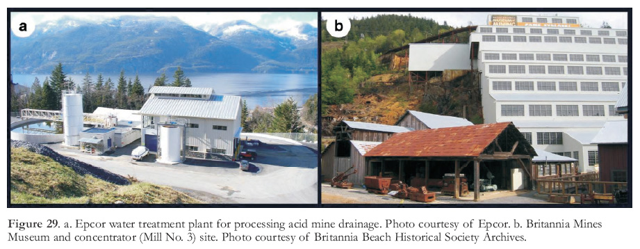 Display large image of Figure 29
THE BRITANNIA BEACH HISTORICAL SOCIETY AND THE BRITANNIA MINE MUSEUM
172 During the seventy-year life of Britannia Mines, many thousands of people of different ethnicities worked and made their homes in the Britannia camps. A 1967 Centennial committee of Britannia residents assumed the task of creating a history of the mine, and to that end it sponsored the publication Britannia – The History of a Mine by Bruce Ramsey (1967). The committee also promoted the formation of the Britannia Beach Historical Society (BBHS), which was created in 1971 as a non-profit organization for the purposes of preserving the Britannia Beach mine site, sustaining the cultural legacy of the Britannia community, and establishing a mining museum. Shortly after the mine closed, the BC Museum of Mining, now renamed the Britannia Mine Museum, opened its doors (Fig. 29b). The Museum is owned by the BBHS.
173 Preservation of the museum site was made possible by a clause in Anaconda’s 1979 sale of the Britannia Beach land package that stipulated that an area of approximately 16 hectares, occupied by buildings of historical interest, be held in trust for the BBHS. The most notable of these buildings is the mine concentrator, which has been designated a National Historic Site.
174 For years after the mine closed, the concentrator was an empty and neglected shell. The corrugated galvanized sheet iron cladding had rusted and in places been partially torn off by the wind, and many of the windows had been broken. In 2007, a major facelift that involved re-cladding and replacement of the windows was completed. The project restored the building to its original appearance, and now the concentrator is a highly visible and impressive sight from the nearby Sea-to-Sky Highway.
175 In 2010 a multi-million dollar museum redevelopment program designed to enhance visitor experience was completed. The funding for the concentrator rehabilitation, which was $5 million, and the museum redevelopment project, estimated to be $14.7 million, has been provided, in approximately equal proportions, by the federal and provincial governments and by generous contributions from mining companies and individuals.
176 Kirstin Clausen, the present Executive Director of the BBHS, offered the following summary of museum history: "Since 1974 when the Museum opened its doors there has been an impressive fusion of staff and volunteers, who have each left an indelible impression from which the Museum has benefited. From only a few paid professional staff, the current Museum has grown in its staff complement to total 18 professionals responsible for artifact collections, education programs, historic interpretation and preservation, marketing and sales. More than 60 000 visitors will visit the Museum in 2011".
177 Museum guests are offered a guided tour that includes an interactive gold panning experience, a visit inside the concentrator where its former operation is explained, and an underground tour that includes a demonstration of rock drills. About 6000 elementary and high school students visit the museum each year through a program that dovetails with the school curriculum. Also, over the years, the museum grounds and tunnel have served as shooting locations for numerous feature films and TV series, including several episodes of the X-Files series.
IMPORTANCE OF THE BRITANNIA MINING CAMP
178 Britannia was economically important because it contributed materially to the province’s young and expanding economy, and because it helped build BC’s reputation as a mineral-rich province. In 1916 Britannia became the largest copper mine in the British Empire, and during the 1920s and 1930s it was one of the largest mining operations in Canada. It was the second largest underground operation in BC in terms of tonnes of ore mined, surpassed only by the Sullivan lead–zinc–silver mine. Prominent underground copper mines or camps that operated in Britannia’s time, such as the Phoenix Camp, the Copper Mountain Camp and the Anyox (Hidden Creek) Mine, had shorter lives and did not approach Britannia’s copper production.
179 The closing of Britannia marked the end of an era in BC mining during which copper production came mainly from underground mines. However, it was seven years after Britannia closed before Lornex, a large open-pit mine in the Highland Valley that opened in 1972, surpassed Britannia in copper production.
180 Britannia is historically significant in being the first mine in BC to successfully employ froth flotation. Moreover, the concentrator (Mill No. 3) was designated a National Historic Site in 1988 in recognition of its economic and historical importance to the Canadian mining industry. The building is the last remaining example in Canada of a gravity-fed concentrator, a design that was once characteristic of many Canadian mining operations. In 1989 the museum site was designated a British Columbia Historic Landmark.
181 The cultural history of Britannia is meaningful because the Britannia communities exemplified a way of life lived by many people of past generations who were associated with the mining and other natural resource industries. Also, unlike many mining communities that have become ghost towns, Britannia Beach has survived and has reinvented itself as a tourist destination.
182 Britannia is also important because it illustrates the environmental, community development and financial reparation problems that can result if acid mine drainage is left uncontrolled after a mine closure. It is, as well, an example of a successful solution to such problems.
Bob Cathro suggested the Great Mining Camps of Canada series as a means of publicizing and revitalizing interest in the historical, economic, scientific and cultural legacies of Canada’s mining industry (Cathro 2006). Steve McCutcheon and Bob Cathro, Assistant Editors for Geoscience Canada, and also Reg Wilson, Editor for Geoscience Canada, made this article much more readable and understandable with their perceptive suggestions. Jane Iverson, assistant curator with the Britannia Mines Museum, was a great help in finding pertinent data in the museum archives and guiding the author to sources of information. Janice Chan of the BC Ministry of Energy, Mines and Petroleum Resources, Mineral Titles Branch, found office boxes containing records of claim staking and claim sales in the area of Britannia Mountain from 1898 to 1902 that were in storage in Victoria, and had them shipped to the Vancouver office of the Mineral Titles Branch for the author’s convenience.
