Articles
Seafloor and Shallow Subsurface of the St. Lawrence River Estuary
SUMMARY
A new surficial geology map of the St. Lawrence River Estuary illustrates sediment distribution and variability in a relatively confined environment. This map is based on recently collected geophysical and geological data that provide a link between submarine land-forms and sedimentary units. The strong dichotomy between the areas to the northeast and to the southwest of the Saguenay River is the main characteristic of the St. Lawrence River Estuary. To the northeast, the Lower St. Lawrence Estuary is mainly floored by fine silts within the Laurentian Channel and sediments varying from sands to fine silts on its margins. To the southwest, the Middle Estuary corresponds to a high-energy sedimentary environment that precludes the deposition of fine-grained sediments. In the latter area, Holocene sediments are either absent or correspond to a sand unit shaped by currents.
SOMMAIRE
Une nouvelle carte de la géologie des sédiments superficiels du fond marin de l’estuaire du Saint-Laurent présente un cas de la distribution et de la variabilité des sédiments dans un environ-nement relativement confiné. Cette carte est basée sur des données géophysiques et géologiques récentes qui assurent un lien entre le relief sous-marin et les unités sédimentaires. La forte dichotomie entre les zones situées au nord-est et au sud-ouest de la rivière Saguenay est la caractéristique principale de l’estuaire du Saint-Laurent. Au nord-est, le fond de l’estuaire maritime du Saint-Laurent est recouvert de silts fins au sein du chenal Laurentien et par des sédiments variant de sables à silts fins sur ses marges. Au sud-ouest, l’estuaire moyen correspond à un environnement sédimentaire de forte énergie qui empêche le dépôt de sédiments fins. Dans cette dernière zone, les sédiments holocènes sont absents ou correspondent à une unité sableuse façonnée par les courants.
INTRODUCTION
1 Estuaries are semi-enclosed coastal bodies of water that have a free connection with the open sea and, within which, seawater is diluted with fresh water derived from land drainage. The location of estuaries at the transition zone between the fluvial and continental shelf environments implies an inherent geological complexity because of the interaction of terrestrial and marine sedimentary processes (Dalrymple and Choi 2007). Several parameters exhibit major changes both along and across the strike of estuaries, including depth, slope, intensity of tidal waves, salinity, and amount of suspended solid, among others. The variability of these parameters and their interaction may lead to a complex sedimentary architecture and influence sediment characteristics such as grain size, sedimentation rate, type of sedimentary structures and geomorphological signature of sedimentary accumulations.
2 The St. Lawrence River system is a major hydrographic feature of North America and is characterized by a large drainage area including and originating at the Great Lakes. In the St. Lawrence River Estuary, Quaternary sediments vary from less than 30 m to over 400 m in thickness (Duchesne et al. 2010). Previous studies of these sediments mainly investigated their overall architecture and the impact of the last glacial episode on the development of the Quaternary succession (e.g. D’Anglejan and Brisebois 1978; Syvitsky et al. 1983; Syvitski and Praeg 1989; Massé 2001; St-Onge et al. 2003, 2008; Duchesne et al. 2010). In this contribution, we focus on the geology of the seafloor and shallow subsurface. This approach became conceivable through the analysis of recently acquired geophysical (multibeam bathymetry and very high-resolution seismic reflection data; Pinet et al. 2011a) and geological (samples and photographs; Campbell 2007; Bolduc 2008) datasets for the St. Lawrence River Estuary. Through a basin-scale approach, the current study attempts to provide a snapshot of present-day sedimentation patterns and accumulations in this large estuarine sedimentary system. Such a snapshot may serve as an analogue for other sedimentary successions for which the physiographic, hydrographic and geologic conditions are uncertain.
HYDROGRAPHIC AND PHYSIO-GRAPHIC SETTINGS
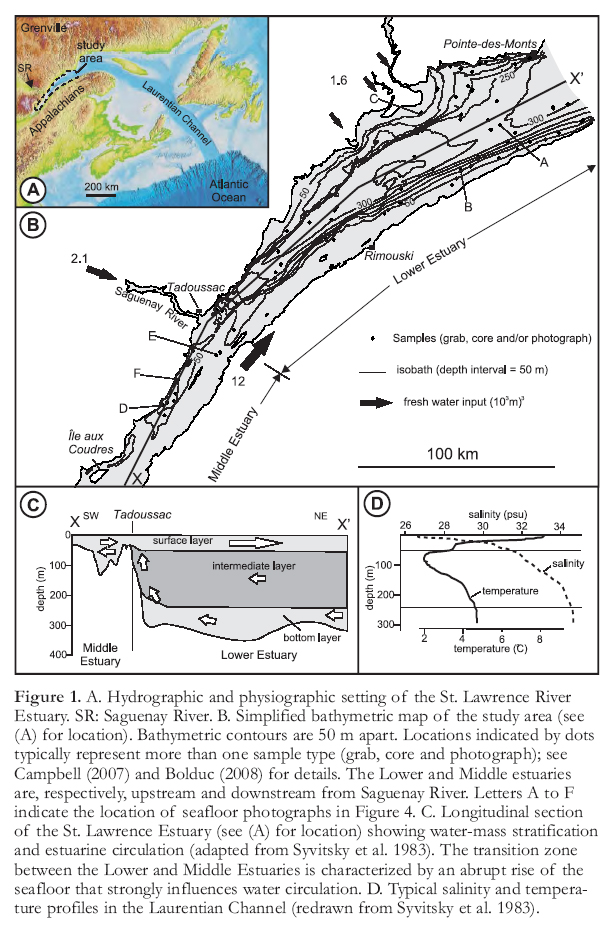
3 The St. Lawrence River Estuary is among the largest in the world, extending for a distance of over 400 km, a width up to 50 km, and a depth of up to 350 m (Fig. 1). On the south shore, the Appalachian Mountains (Fig. 1A) exhibit relatively smooth relief, and elevation is generally less than a few hundred metres. The north shore, under-lain by Grenvillian metamorphic rocks of the Canadian Shield (Fig. 1A), rises steeply and reaches elevations of more than 1000 m south of the Saguenay River.
4 The St. Lawrence River Estuary is traditionally divided into two segments on the basis of bathymetric signature (Fig. 1B); the Lower Estuary, which extends from the mouth of the Saguenay River northeast to Pointedes-Monts, and the Middle Estuary, which encompasses salt water southwest of the Saguenay River. A distinctive feature of the Lower Estuary is the Laurentian Channel, which extends more than 900 km from the confluence with Saguenay River to the edge of the Scotian Shelf in the Atlantic Ocean (Fig. 1A). In the southwest part of the Lower Estuary, the Laurentian Channel exhibits the morphological signature of an incised-valley bounded by steep escarpments, whereas to the north, it is characterized by more shallowly dipping margins. Differential erosion has traditionally been considered as the main geological process responsible for the parallelism of the Laurentian Channel with bedrock boundaries, as it is hosted by softer rocks of the St. Lawrence Platform that are less resistant to erosion than the adjacent Grenvillian and Appalachian rocks (Pinet et al. 2008). The Middle Estuary is shallower and characterized by a ‘rougher’ bathymetry, including a network of interconnecting channels and basins between northeast-striking, kilometre-wide banks and islands.
5 The mean tidal range of the study area increases toward the southwest, from 3.0 m near Pointe-des-Monts to 4.4 m at Tadoussac (extreme high water of 4.9 and 6.4 m respectively; Fisheries and Oceans Canada 2010). The estuary is characterized by a salinity-induced density stratification leading to the development of an estuarine circulation in which the denser, more saline bottom water flows slowly (~ 0.5 km/day) landward at the bottom of the estuary, whereas fresher water moves rapidly (~ 10–20 km/day) seaward at the surface (Fig. 1C; Syvitski et al. 1983). Intensive mixing between water layers occurs at the head of the Laurentian Channel, which is characterized by a sudden rise of the seabed near Tadoussac (Fig. 1C).
 Display large image of Figure 1
6 During the spring and summer, the water masses have a well-developed thermocline characterized by three layers (Syvitski et al. 1983; Fig. 1D). The minimum temperature (2°C) is found in the intermediate water layer (50–250 m). Salinity of the surface layer (0–50 m) ranges from 26–31 psu (practical salinity unit) and steadily increases to 34.5 psu on the river bottom (Syvitski et al. 1983; Fig. 1D). Since the 1930s, a steady decrease of oxygen concentration in bottom waters has been documented (Gilbert et al. 2005).
7 The main sources of fresh water are the St. Lawrence River (12 000 m3/s near Tadoussac), the Saguenay River (2100 m3/s) and three large rivers on the north shore ─ the Betsiamites, Aux Outardes and Manicouagan rivers, which have a combined discharge of 1600 m3/s (Fisheries and Oceans Canada 2010). The St. Lawrence River alone transports more than 6.5 million tonnes of suspended solid into the Lower Estuary annually (Fisheries and Oceans Canada 2010). North of Saguenay River, most of these sediments are deposited on the floor of the Laurentian Channel, which previous studies have indicated to consist mainly of dark grey, bioturbated, fine silts (Nota and Loring 1964; St-Onge et al. 2003). Estimates of recent sedimentation rates range from 0.70 cm/yr off Rimouski to 0.22 cm/yr in the northern part of the study area (Smith and Schafer 1999).
DATASETS AND METHODOLOGY
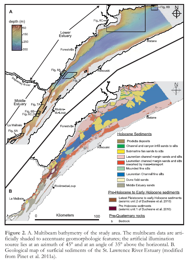
8 Complete multibeam bathymetry coverage for water depths greater than 30 m is available between Îles aux Coudres to the southwest and Pointedes-Monts to the northeast (Figs. 1B, 2A). The bathymetric coverage includes several surveys conducted between 1997 and 2007 by the Canadian Hydrographic Service using the Canadian Coast Guard Ship Frederick G. Creed and the bathymetric launch Guillemot. Multibeam systems onboard the F.G. Creed consisted of a Kongsberg EM-1000 (before 2005) and a Kongsberg EM-1002 (since 2005). On the Guillemot, multibeam systems consisted of a Kongsberg EM-3000 (before 2005) and a Kongsberg EM-3002 (since 2005). In addition to multi-beam bathymetry, very high-resolution seismic reflection data (not shown) have been employed to image the shallow subsurface of the St. Lawrence River Estuary. These seismic data, which were collected in 2007 using a Huntec DTS source with a peak frequency of ~900 Hz, have a vertical resolution of ~0.8 m (Campbell 2007; Bolduc 2008).
 Display large image of Figure 2
9 One hundred and forty-five seafloor sediment samples (86 grab samples and 59 short gravity cores less than 2 m long) and 79 seafloor photographic transects (consisting of 8 to 21 images) were collected at strategic sites to characterize surficial units (Campbell 2007; Bolduc 2008; Fig. 1A). Seafloor samples and photographs provide the critical link between the geomorphological units identified on multibeam bathymetry and the lithological characteristics of sediments.
10 During this study, surficial geology units (Fig. 2B) were primarily defined on the basis of their geomorphological signature (Pinet et al. 2011a). Surficial units consist either of homogeneous and well-sorted sediments (such as the Holocene Laurentian Channel fine silt unit; see below) or sediments with variable grain-size characteristics (such as the Holocene Laurentian Channel-margin sand to silt unit; see below). In most cases, surficial geology units have relatively sharp boundaries on the multibeam bathymetry map. Where not obvious on bathymetric images, unit boundaries were defined on very high-resolution seismic lines and extrapolated from one line to the other. This was the case for the lower and upper boundaries of the latest Pleistocene to early Holocene sediment unit; these boundaries are easily identifiable on several seismic lines yet exhibit no clear geomorphological signature. Very high-resolution seismic lines were also critical for the interpretation of linear features associated with buried structures such as bedrock ridges (Pinet et al. 2011a).
RESULTS
Background Sediments in the Laurentian Channel
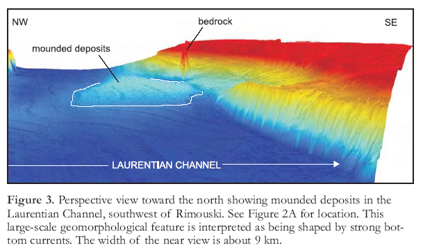
11 Northeast of the Saguenay River, the Laurentian Channel lies at depths averaging ~300 m and is characterized by a smooth geomorphologic signature lacking landforms associated with the glacial history. A ~17-km-long and ~6-km-wide mounded sedimentary body observed ~50 km southwest of Rimouski constitutes the main large-scale geomorphologic feature on the Laurentian Channel seafloor (Fig. 3). On seismic profiles, this feature is characterized by medium-amplitude sigmoidal reflections that led Duchesne et al. (2010) to propose that strong bottom currents in this area are responsible for shaping it. At a smaller scale, the Laurentian Channel seafloor is characterized by close to 2000 pock-marks ranging in diameter from <50 to ~700 m. These crater-like depressions have been studied in detail by Pinet et al. (2008, 2010) and Lavoie et al. (2010), and are interpreted to have formed through the release of gas from the subsurface.
12 Present-day sedimentation in the Laurentian Channel, including the mounded unit, consists of fine silt. Photographic analysis indicates no major variations in the grain size of surficial sediments. The majority of photographs exhibit evidence of bioturbation, with micro-relief, including burrow openings, up to a few centimetres in length (Fig. 4A). The most common macrofauna consists of sea pens, anemones and brittle stars. Grain size analysis of the sediments indicate a homogeneous lithology, having a gravel content consistently less than 1%, a cumulative sand+gravel content usually less than 3%, and a silt content varying between 49 and 60% (Fig. 5A). One sample of coarser grained sediment is located close to a mass-transport deposit, and another within a pock-mark (Fig. 5A). These results compare well with previous studies reporting grain size analysis in the Laurentian Channel (Loring and Nota 1973; St-Onge et al. 2003).
 Display large image of Figure 3
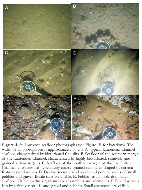 Display large image of Figure 4
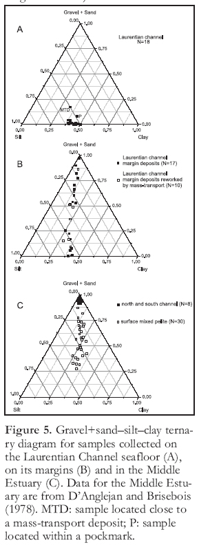 Display large image of Figure 5
Background Sediments on the Laurentian Channel Margins
13 The geomorphological signature of both the northwest and southeast margins of the Laurentian Channel is more diversified than within the channel itself. Both margins of the Laurentian Channel are characterized by an average down-dip slope of generally less than 2°. Along a significant portion of the estuary (Fig. 1), the boundary with the Laurentian Channel is marked by a bathymetric break expressed by escarpments (up to 180 m in height) or bedrock ridges (up to 90 m in height) that are the morphological expression of bedrock faults and erosion-resistant Paleozoic bedrock (Pinet et al. 2008). On the north shore, the margin locally displays linear features interpreted as paleo-iceberg scours (Pinet et al. 2011a).
14 Grain sizes of present-day sediments on the Laurentian Channel margins show a transition from sand to fine silt (Fig. 5B). However, the character of surface sediments changes rapidly over short distances in some areas, especially in the shallowest parts of the study area, and the gravel content of studied samples is locally over 10%. Photographs indicate that margin sediments are generally highly bioturbated (Fig. 4B). Current-shaped sedimentary structures such as sand waves up to a few decimetres in wavelength are locally observed at relatively shallow (< 100 m) water depth (Fig. 4C).
Background Sediments in the Middle Estuary
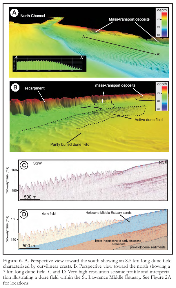
15 South of Saguenay River, Holocene sediments are mainly sand, which is commonly shaped into large current features such as dune fields up to 10 km in length and 2 km in width (Figs. 2 and 6). These features are characterized by linear or curvilinear crests up to 4 m high and 100 m in wavelength, having an average strike perpendicular to the estuary (Fig. 6; D’Anglejan 1971). Isolated barchans located close to dune fields are locally imaged on the multibeam bathymetry map (Pinet et al. 2011a). Dune fields attest to a well-established, tidally driven bottom current system upstream of the Saguenay River (D’Anglejan 1971) where the estuary drastically narrows and shallows. Grain size analysis indicates that dune field sediments consist of well-sorted sands and minor gravel (Figs. 4D and 5C; D’Anglejan and Brisebois 1978); finer grained sediments are also present, yet fine silts such as those observed in the Lower Estuary are notably absent (Fig. 5C).
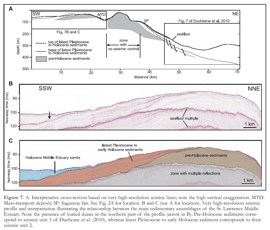
16 Northeast-striking high-resolution seismic lines (Fig. 7; see also Figure 7 of Duchesne et al. 2010) indicate that a latest Pleistocene to early Holocene regional-scale seismic marker (seismic unit 2 of Duchesne et al. 2010) dips away from a bathymetric high located near the mouth of Saguenay River. The upper and lower contacts of the seismic marker unit have no clear geomorphological signature. In the shallow parts of the bathymetric high, the oldest (pre-Holocene, but still undated) seismic unit (seismic unit 1 of Duchesne et al. 2010) crops out, indicating that erosion processes predominate over sedimentation in this area (Fig. 7A). On multibeam bathymetry images (Fig. 2), pre-Holocene sediments form a hummocky seafloor with short, elongated morphologic lows that strike in various directions and most likely result from iceberg scouring (Pinet et al. 2011b). Submarine photographs in this area indicate that the seafloor is either dominated by pebbles and cobbles (Fig. 4E) or made up of a light grey to bluish clay (Fig. 4F) that is locally overlain by a cm-thick discontinuous veneer of sand. The bluish clay corresponds to the type 2 (relict) pelites of Loring and Nota (1973) and to the blue-grey (layer 3) pelites of D’Anglejan and Brisebois (1978). Regionally, this clay unit is dated at around 12 000 years BP (calibrated) (St-Onge et al. 2008), confirming the seismic interpretation that Holocene sediments are absent in this area.
Fan Deposits
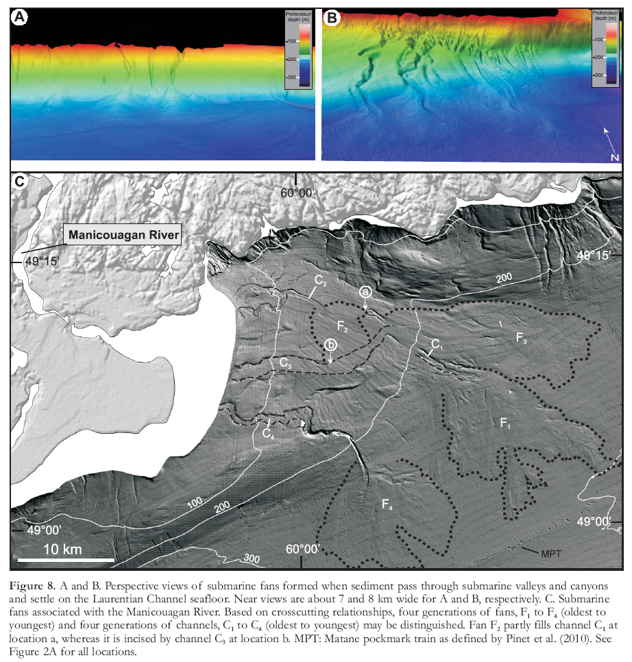
In both the Lower and Middle estuaries, gently sloping, subtle geomorpho-logical features define cone-shaped units up to 15 km in width that are interpreted as submarine fans (Figs. 2B and 8). In several cases, fan sediments were diverted from the northwest and southeast margins of the estuary and delivered to fans located on the Laurentian Channel seafloor through submarine valleys and canyons (Fig. 8A, B). Fan sediments show significant grain size variability from sand to silt. Some segments of the submarine valleys and canyons have steep flanks, suggesting that at least some sediment was transported by turbidity flows that eroded the valley and canyons at the same time (Gagné et al. 2009). This transfer of coastal sediments to deeper environments contributes to the negative sediment budget along the coast. Locally, fans and channels show multiple crosscutting relationships that indicate a polyphase sedimentary history, such as at the mouth of Manicouagan River, where four generations of fans and channels can be distinguished (Fig. 8C).
 Display large image of Figure 6
Mass-Transport Deposits
17 Seafloor instability features have been previously described for some parts of the St. Lawrence River Estuary (Cauchon-Voyer et al. 2008; Campbell et al. 2008). However, analysis of the multi-beam bathymetry dataset indicates that submarine slides occur on a much larger scale than previously recognized and that sediments are reworked by mass-transport along significant segments of the Lower and Middle estuary margins. In the study area, 111 mass-transport deposits have been identified, representing 13% of the map area. Detailed study of mass-transport deposits is the objective of a companion paper.
18 Steep bedrock walls located along some segments of the St. Lawrence River Estuary, as well as earthquakes occurring in this seismically active area (Mazotti et al. 2005; Lamontagne 2009), act as a major predis-posing factor for mass-transport (e.g. Syvitski and Praeg 1989; Duchesne et al. 2003; Campbell et al. 2008; Cauchon-Voyer et al. 2008). In the Betsiamites area, Cauchon-Voyer et al. (2008) recognized four phases of submarine landsliding since 9 ka BP. No additional constraints on the timing of mass-transport deposit emplacement have been collected during this study. However, the transition from submarine slides with a fresh geomorphological signature to partly buried slides with a subdued signature, as well as the large volume of sediments reworked by mass-transport processes on both flanks of the St. Lawrence River Estuary, suggest that the deposits result from several catastrophic events, at least some of which were likely triggered by earthquakes (Cauchon-Voyer et al. 2008; Campbell et al. 2008).
DISCUSSION
19 Short-term marine hydrodynamics is an important factor controlling sedimentation in estuaries (Dalrymple and Choi 2007). Because of the narrowing of the St. Lawrence River upstream of Saguenay River and the shallowing of the river floor – two characteristics largely inherited from bedrock geology (Pinet et al. 2008) – tidal height is amplified in the Middle Estuary compared to the Lower Estuary. In the Middle Estuary high-energy environment, which is characterized by a complex interplay of waves and tides, the Holocene sediment fill is reduced or absent (Fig. 7A).
20 Upstream of Saguenay River, bottom currents are strong enough (generally 50–100 cm/sec, locally up to 150 cm/sec; D’Anglejan and Brisebois 1978) to locally generate large-scale migrating submarine bedforms in sandy material (Syvitski et al. 1983; Bolduc and Duchesne 2009; Fig. 6). The sand may have been remobilized either from the bathymetric high close to the Saguenay River mouth, which is more exposed to currents, or from Quaternary deposits on the shore that have been reworked by tides, fluvial erosion and ice rafting. However, these bottom currents are unlikely to have mobilized larger cobbles, which are major constituents of the seafloor in some areas (Fig. 4E). Alternative hypotheses for the formation of coarse-grained deposits include: 1) erosion of the fine-grained fraction by tidal re-suspension and formation of a residual seafloor comprising only the coarse fraction; 2) remobilization of coarse-grained sediments from the shore, followed by relatively short transport and sedimentation during the yearly ice break-out period, as documented by Dionne (1993); and 3) remobilization by storm waves of coarse-grained pre-Holocene sediments forming the shallow (10–100 m) part of the St. Lawrence seafloor close to the mouth of Saguenay River.
 Display large image of Figure 7
21 North of Saguenay River, in the Laurentian Channel, sediments are interpreted to have been deposited from the suspended load present in the Lower Estuary. At the depths of the Laurentian Channel seafloor (>250 m), turbulence from tides and storm surges is not intense enough to cause re-suspension of fine silts, and erosion by post-sedimentation processes is minor.
22 In contrast, and as proposed by Loring and Nota (1973), the grain-size distribution of sediments deposited on some relatively shallow parts of the Laurentian Channel margins can be explained by turbulence from tides and storm surges, causing re-suspension of fine silts. The grain-size distribution of sediments on the margins is also a function of local sedimentary sources (i.e. St. Lawrence River tributaries) that may carry significant amounts of sediment. Fluvial input generally supplies fine-grained sands and muds whereas the coarser sands are supplied by bed and shore erosion.
 Display large image of Figure 8
CONCLUSION
23 Compared with other estuaries, in which facies characteristics and distribution record a complex but often progressive transition of physical processes from river-dominated (river current) to marine-dominated (waves and tides), the St. Lawrence River Estuary is characterized by a sharp variation in sedimentary processes in the Middle versus the Lower Estuary. This variation is a consequence of contrasting hydrodynamic conditions related to major changes in the shape of the St. Lawrence River Estuary. In the relatively shallow (generally less than 100 m) Middle Estuary, bedload reworking by bottom currents is the main process and precludes the deposition of Holocene fine-grained sediments. In some areas, erosional processes predominate over sedimentation and pre-Holocene sediments form the seafloor. In the Lower Estuary (northeast of Saguenay River), sedimentation from suspended load is the predominant mechanism. Surficial sediments are Holocene in age and correspond to fine silt except close to local sedimentary inputs and in shallow areas where turbulence from tides and storm surges may cause re-suspension of fine-grained sediments.
ADDITIONAL MATERIAL
24 A 1:250 000 surficial geology map as well as twelve 1:50 000 shaded seafloor relief maps are available for free download at: http://geoscan.ess.nrcan.gc.ca/star-web/geoscan/servlet.starweb?path=geoscan/geoscan_f.web
We thank the officers and crew of the CCGS F.G. Creed and Matthew as well as the personnel of the Canadian Hydrographic Service for their professionalism and support. D. Lavoie is acknowledged for his review of a preliminary version of the manuscript. This article benefitted from reviews by John Shaw and an anonymous reviewer as well as comments and suggestions by the editor, Reginald Wilson. This is Geological Survey of Canada contribution No 20100427.