Article
Ongoing Neotectonic Activity in the Timiskaming ─ Kipawa Area of Ontario and Québec
Michael DoughtyDepartment of Geography and Earth Sciences, McMaster University, Hamilton, ON, Canada, L8S 4L8
Nick Eyles
Department of Geology, University of Toronto at Scarborough, Scarborough, ON, Canada, M1C 1A4
eyles@utsc.utoronto.ca
Louise Daurio
Department of Geology, University of Toronto at Scarborough, Scarborough, ON, Canada, M1C 1A4
Received April 2010, Accepted as revised September 2010
SUMMARY
The Timiskaming Graben lies along the border of Ontario and Québec within the Western Québec Seismic Zone – a conspicuous belt of heightened intracratonic seismic activity in eastern Canada. The graben forms a prominent 50-km wide fault-bounded morphotectonic depression partly filled by Lake Timiskaming (ca. 100 km long and 200 m maximum depth). This lake is a postglacial successor to the much larger glacial Lake Barlow, which drained about 8000 years ago, leaving an extensive clay plain (Little Clay plain). Some 1000 kilometres of high resolution seismic sub-bottom data collected from Lake Timiskaming reveal that both late-glacial Barlow and postglacial Holocene sediments are extensively deformed by neotectonic horst and graben structures. The bathymetry of the lake floor is structurally controlled by faulting; graben basins record enhanced postglacial subsidence between parallel bounding faults, one of which is expressed onshore on the surrounding clay plain as a 20-km long, 10-m high scarp. These structures indicate ongoing neotectonic activity on a scale not recognized elsewhere across intracratonic North America. Seismic reflection data confirm the Timiskaming Graben as an intraplate ‘weak zone’ that may contain a long, late Cenozoic sediment record. A program of deep continental drilling within the Timiskaming Graben and extension of the current program of investigating lake-floor geology across the many lakes of the Western Québec Seismic Zone are now needed.SOMMAIRE
Le graben de Témiscamingue est situé le long de la frontière entre le Québec et l’Ontario, au sein de la Zone sismique de l’Ouest du Québec – une zone notable de plus grande activité sismique intracratonique de l’est du Canada. Le graben forme une dépression morphotectonique de 50 km de largeur délimitée par des failles, partiellement remplie par le lac Témiscaminque (environ 100 km de long et une profondeur maximale de 200 m). Ce lac est le successeur postglaciaire du lac Barlow, bien plus grand, qui s’est drainé il y a 8 000 ans environ, exposant une grande plaine alluvionnaire argileuse (plaine de Little Clay). Quelques 1 000 km de données sismiques haute résolution des couches proximales du fond du lac Témiscamingue montrent que tant les sédiments holocènes de la fin du lac glaciaire Barlow que les sédiments postglaciaires sont considérablement déformés par des structures néotectonique de horst et graben. La bathymétrie du plancher du lac est structurellement déterminée par la formation de failles; les bassins de graben ont enregistré un accroissement de la subsidence postglaciaire entre les failles bordières, et l’une d’elle se manifeste par un escarpement exondé de 10 m de hauteur sur 20 km de longueur qui surplombe la plaine alluvionnaire environ-nante. Ces éléments structuraux sont l’indication d’une activité néotectonique persistante, à une échelle qui n’existe nulle part ailleurs dans le craton nord-américain. Les données de sismique réflexion confirme que le graben de Témiscamingue est une zone de « faiblesse » intraplaque qui pourrait renfermer un registre sédimentaire Cénozoïque étendu. Il faut maintenant lancer un programme de sondages continentaux profonds à travers le graben de Témiscamingue et prolonger l’actuel programme d’étude géologique des fonds des lacs de la Zone sismique de l’Ouest du Québec.INTRODUCTION
1 The M 5 Earthquake of June 23rd, 2010 centred 60 km northeast of Ottawa within the Western Québec Seismic Zone (Fig. 1), rattled much of central Canada and is a reminder that intracra-tonic seismicity in heavily urbanized central and eastern North America is still not well understood (Stein and Mazzotti 2007). The Western Québec Seismic Zone poses a direct risk to infrastructure such as mines, lifelines, critical facilities and the large urban areas of Montréal and Ottawa, where soft glaciomarine sediments (Leda Clay) and aged infrastructure compound seismic risk (Motazedian and Hunter 2008; Rosset and Chouinard 2008). There is still inadequate knowledge of earthquake source zones, recurrence intervals, and the effects of postglacial rebound (Ma et al. 2008), so emphasis is placed on the geologic and geomorphic record of seismic activity (e.g. Shilts and Clague 1992; Kelson et al. 1996; Ouellet 1997; Aylsworth et al. 2000; Tuttle 2001; Talwani and Schaeffer 2001). Our purpose here is to highlight the wealth of neotectonic structures that deform the bottom sediments of lakes Kipawa and Timiskaming within the Timiskaming Graben along the border of Ontario and Québec (Fig.2). We also identify a prominent 20 km-long onshore scarp that is inferred to be a product of co-seismic faulting.
Figure 1. Earthquake epicentres within the Western Québec Seismic Zone (source: Geological Survey of Canada) and principal faults (a to e) associated with Timiskaming Graben (Fig. 2).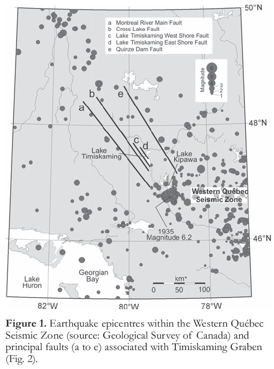
Display large image of Figure 1
TIMISKAMING GRABEN
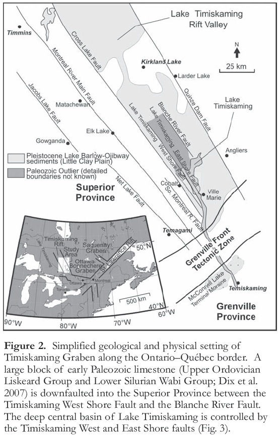
2 The Timiskaming Graben (TG) parallels the Ontario–Québec border and is structurally defined by the Cross Lake Fault and the Quinze Dam Fault (Fig. 2). It is a complex structure that likely first developed as part of the Paleoproterozoic (ca. 2.4 Ga) ‘Cobalt Embayment’; it was much later reactivated during regional extension related to the breakup of Rodinia and Pangea (Barosh 1990; Mazzotti 2007) and during compression related to various Appalachian orogenies (Kumarapeli and Saul 1966; Dix and Molgat 1998). The TG transects the Grenville Front Tectonic Zone, which separates the Grenville and Superior provinces, and merges with the Ottawa-Bonnechere Graben before joining the St. Lawrence Rift (Fig. 2). The entire system is a broad belt of heightened seismic activity known as the Western Québec Seismic Zone (Fig. 1), which encompasses the large urban areas of Ottawa–Hull and Montréal, and extends to Lake Champlain and Vermont, USA (Fig. 2). The history of earthquake activity in this area is therefore of international concern.
3 Basement to TG consists of Paleoproterozoic and Archean rocks of the Canadian Shield (Lovell and Caine 1970; Lovell and Frey 1976; Russell 1984; Johnson et al. 1992; Dix and Molgat 1998). The graben preserves outliers of Ordovician to Silurian limestones of the Upper Ordovician Liskeard Group and Lower Silurian Wabi Group (Dix et al. 2007) that are downfaulted by as much as 300 m into older Shield strata (Fig. 2). Glacial Lake Barlow was located within the confines of TG between 9000 and 8000 years before present (BP), during Laurentide Ice Sheet deglaciation (Barnett 1992; Dyke 2004; Cronin et al. 2008). The exposed floor of glacial Lake Barlow is referred to as the ‘Little Clay plain’ (informal term; Fig. 2) and is underlain by glaciolacustrine silty clays (varves). Lake Timiskaming (100 km long, 200 m maximum depth) is the postglacial successor to glacial Lake Barlow; Barlow varved clays are present below the floor of Lake Timiskaming as far south as the McConnell Moraine (Fig. 2). The moraine was deposited on a topographic ridge along the Grenville Front Tectonic Zone and forms the southern termination of glacial Lake Barlow (Veillette 1994).
HIGH-RESOLUTION SEISMIC IMAGES OF NEOTECTONIC STRUCTURES IN LAKE TIMISKAMING
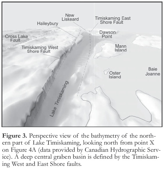
4 One thousand kilometres of high-resolution seismic data were collected on Lake Timiskaming using an EdgeTech X-STAR digital seismic profiling system (see Lazorek et al. 2006 for details). Multibeam data collected by the Canadian Hydrographic Survey (Canadian Hydrographic Survey 2004) were also used to relate bathymetry to deformation structures seen on seismic profiles. Lake Timiskaming is a large lake ─ 14 km wide in its northern part, and some 100 km in length. To the north, its linear western margin is sharply defined by the Timiskaming West Shore Fault (Figs 2, 3, 4). The central basin is bordered on its Québec side by shallow (<5 m) wave-cut ‘shelves’ and several limestone islands and intervening bays (Fig. 3).
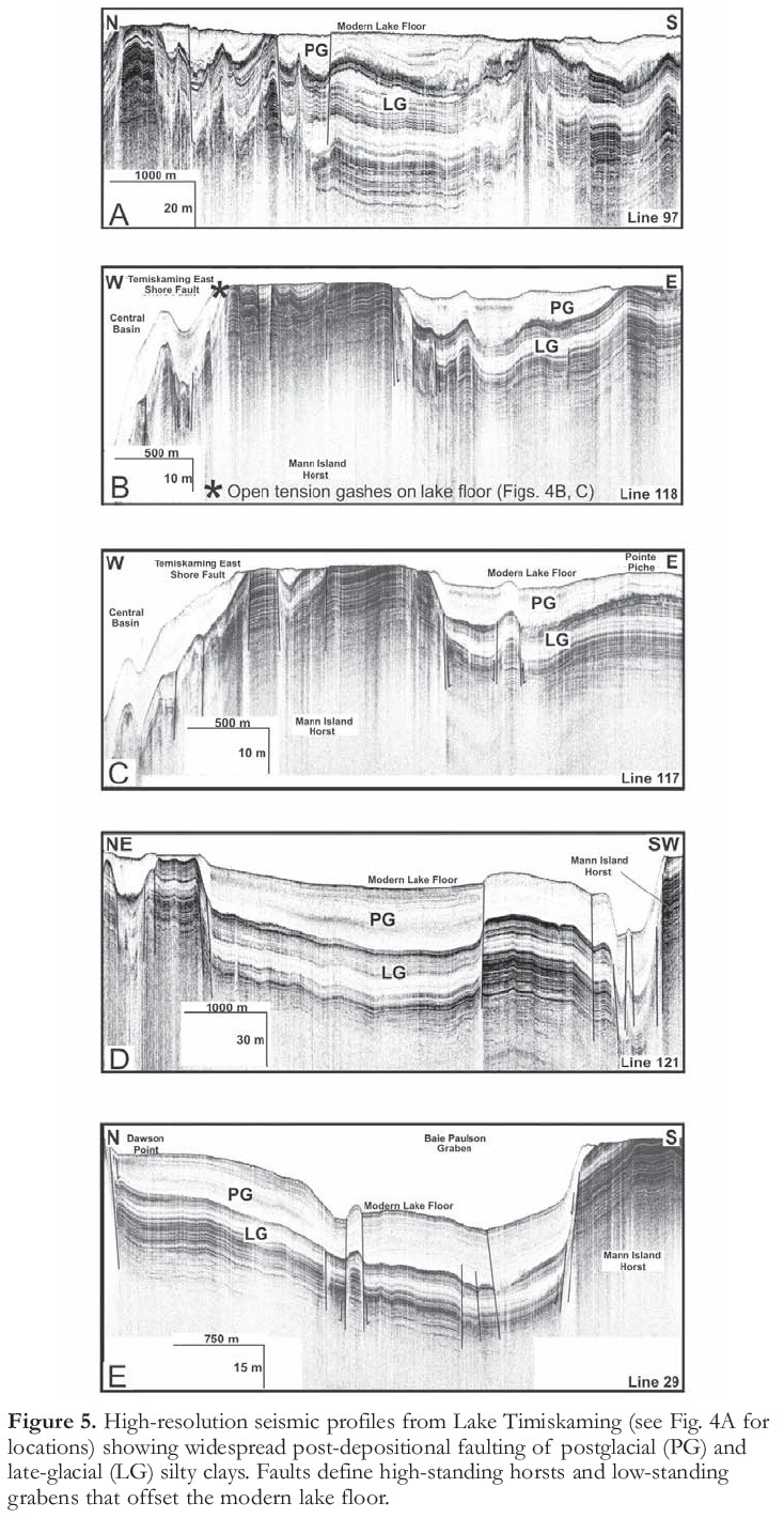
Figure 4. A. Shaded-relief image of northern end of Lake Timiskaming showing locations of offshore seismic track lines (Fig. 5A–E) and the Thornloe–New Liskeard fault scarp on the east side of the northerly extension of the Timiskaming East Shore Fault. Points X and Y and prominent arrows indicate viewpoints and ‘look’ directions for Figures 3 and 7, respectively. B. Multibeam mapping and C. side-scan profiling reveal that the East Shore fault is associated with open tension gashes on the floor of Lake Timiskaming (site marked with a star on A; see also Fig. 5B) despite high modern sedimentation rates, indicating ongoing neotectonic activity. Several northwest–southeast trending lineaments remain to be investigated in detail.
Display large image of Figure 4
Display large image of Figure 5
5 Seismic data reveal two seismic-stratigraphic successions below the floor of the lake (Fig. 5). Parallel high-frequency reflectors typical of varved glacial Lake Barlow silty clays characterize the older succession (Shilts 1984), which is overlain by a largely transparent, reflector-free Holocene succession. Within Lake Timiskaming, the younger succession is unusually thick (40 m) compared to other glaciated ‘Shield’ lake basins (Shilts and Clague 1992; Lazorek et al. 2006) because of high sediment inputs from several large inflowing muddy rivers that rework glacial Lake Barlow sediment. The seismic survey shows that the late-glacial and postglacial sediment fill of Lake Timiskaming is extensively and severely deformed by horst and graben structures that control the topography of the lake floor (Figs. 4, 5A-E). The remarkably linear, parallel-sided, central deep-water basin of Lake Timiskaming (Fig. 3) is a trench-shaped graben resulting from subsidence between the Timiskaming West Shore Fault (TWSF) and another hitherto undiscovered fault that is named herein the Timiskaming East Shore Fault (Figs. 2, 3, 5B, 5C, 6). The latter trends north–south parallel to the TWSF through Dawson Point and the west side of Mann Island and actually consists of a zone of closely spaced faults (Fig. 5B, C). Shallow-water bays on the eastern margin of the lake, such as Baie Joanne (Fig. 3) and Baie Paulson (Fig. 4A) are the expression of small grabens containing downfaulted late-glacial and postglacial sediments, lying between limestone islands that form horsts (Fig. 6). A detailed 3-D reconstruction of faults is being presented elsewhere, but we can report sidescan records of several examples of open lake-floor fissures above faults, indicating recent or ongoing activity (Fig. 4B, C). Deformation is not restricted to a short phase of heightened glacioisostatic rebound immediately following deglaciation, as reported elsewhere in intracratonic settings (e.g. Lagerback 1992), because such structures would be buried below modern sediment. Instead, deformation has affected the modern lake floor and is ongoing.
Figure 6. Simple structural model of the Timiskaming Graben as suggested by this study. Drilling is required to understand the deeper fill, which may contain a long late Cenozoic sediment and climate record.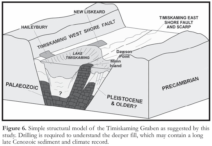
Display large image of Figure 6
6 Faulting in the northern part of Lake Timiskaming was briefly reported by Shilts (1984) and attributed to late-glacial glaciotectonic processes involving collapse over buried ice blocks, although it was noted that post-glacial sediments had also been displaced. Shilts and Clague (1992) later suggested a link to the M 6.2 Timiskaming Earthquake in 1935. Doig (1991) reported deformation structures in short drill cores and attributed the deformation to seismic shaking. Our substantial seismic coverage demonstrates a pronounced structural control on modern lake-floor topography that is consistent with earthquake-related neotectonic activity. In particular, the faulting of both post-glacial and late-glacial sediments indicates a neotectonic, not glaciotectonic origin.
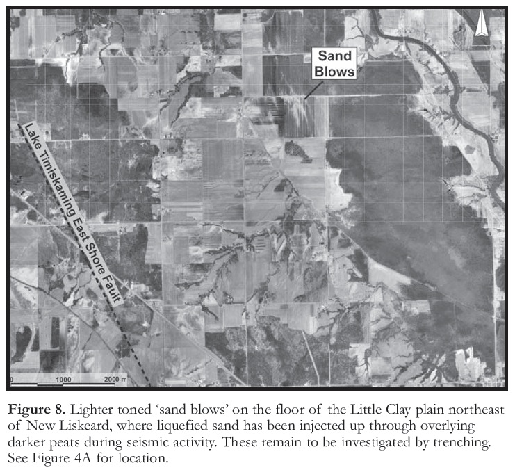
7 Tectono-geomorphic features on the surface of the Little Clay plain appear to provide evidence for rapid subsidence during at least one post-glacial earthquake. A remarkably linear, 20 km long, 10 m high, northwest-trending, west-facing scarp between Thornloe and New Liskeard (Fig. 7) coincides with the northern extension of the Timiskaming East Shore Fault interpreted from offshore seismic profiles. Previous workers had suggested that the scarp is the surface expression of a bedrock fault (Lovell and Frey, 1976; Russell 1984) whereas others mapped it as an abandoned glacial Lake Barlow shoreline bluff (Morton et al. 1979). Beach deposits were not observed along the length of the scarp, whose striking linearity is markedly different from other shorelines on the Little Clay plain. The onshore scarp and the Timiskaming East Shore Fault likely record one or more large prehistoric earthquakes and subsidence of the central basin between the Timiskaming West and East Shore faults (Fig. 3). Subsidence of the Little Clay plain has promoted the growth of extensive peat deposits, some of which are covered by ‘run-out debris’ from mudflows that record local landsliding of glaciolacustrine silty clays down the scarp face. It is possible that these mudflows may have neotectonic significance; i.e. they may have been triggered by earthquake activity. Possible ‘sand blows’ or sand volcanoes (Tuttle 2001) where sand has been injected upward through peat, are noted (Fig. 8). Examination and coring of the buried peat stratigraphy below landslide deposits, and in sand blows, may ultimately yield a dateable record of tectono-geomorphic activity.
Figure 7. Thornloe–New Liskeard fault scarp. View is looking east from point Y on Figure 4A.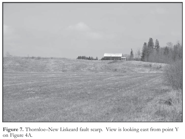
Display large image of Figure 7
Display large image of Figure 8
8 Evidence of earthquake-triggered sediment slumping that can be related to a specific earthquake is found on the floor of Lake Kipawa, east of Lake Timiskaming (Doughty et al. 2010; Figs 1, 9). Like Lake Timiskaming, its sediment infill consists of Barlow silty clays (maximum thickness 30 m) overlain by a thin (<5 m) succession of organic-rich Holocene sediment. High-resolution seismic profiling on Lake Kipawa (not shown) reveals some 35 distinct locations where the sediments of both successions have experienced downslope failure; these large slumps are characterized by hummocky mounds of thickened and contorted deposits. Shilts (1984) reported their presence in Lake Kipawa and also recognized them in nearby Lake Tee (Fig. 9). Detailed mapping of these landslides reveals that they occur within a broad 600 km2 zone around the epicentre of the 1935 Timiskaming Earthquake (Fig. 9).
Figure 9. Distribution of landslides across the floor of Lake Kipawa produced by the 1935 Timiskaming Earthquake (M 6.2). Modified from Doughty et al. (2010).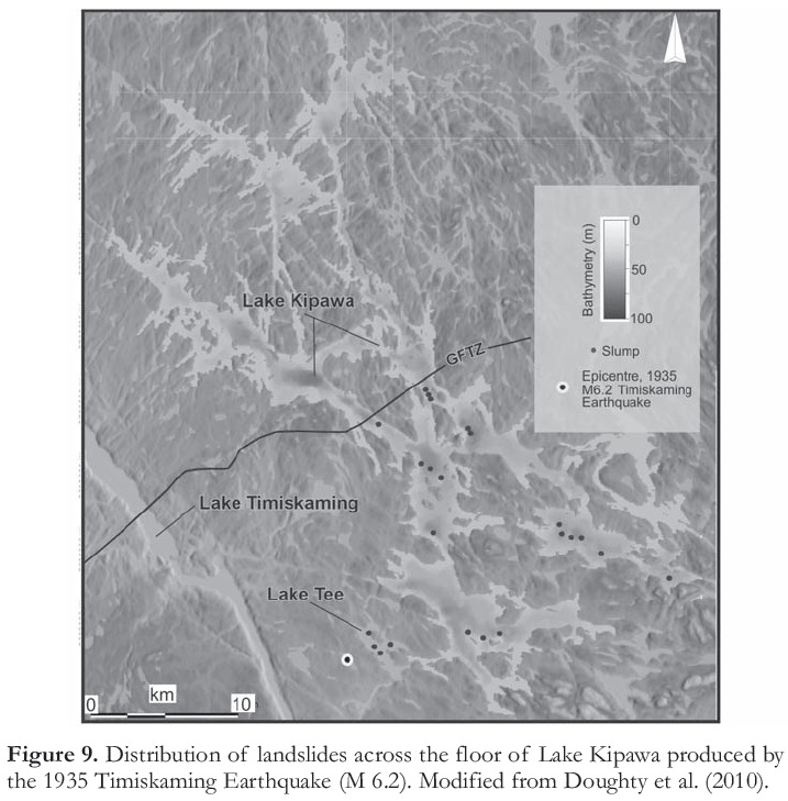
WIDER SIGNIFICANCE
9 To our knowledge, the scale and type of active neotectonic deformation in the Timiskaming Graben briefly reported herein is, so far, unique in eastern North America (Kelson et al. 1996; Tuttle 2001; Talwani and Schaeffer 2001; Stein and Mazzotti 2007). The deformation is interpreted to reflect frequent seismic activity and associated crustal deformation in the Western Québec Seismic Zone. This finding is consistent with Mazzotti’s (2007) identification of the Timiskaming Graben as a persistent ‘weak zone’ within the otherwise rigid North American craton. Kumarapeli and Saul (1966) compare the Proterozoic–Phanerozoic development of the St. Lawrence Rift to the modern East African Rift, and, indeed, the graben infill of Lake Timiskaming is similar to that in other rift basins worldwide (e.g. Scholz et al. 1998; Gawthorpe and Leeder 2000; Withjack et al. 2002).
10 The Western Québec Seismic Zone is one of the most active seismic zones in eastern North America; large, damaging earthquakes occurred in 1732 (Montreal; M 5.8), in 1935 (Temiscaming; M 6.2) and in 1944 (Cornwall; M 5.6). The epicentre of the 1935 earthquake was located 10 km east of Lake Timiskaming near Lake Kipawa and is recorded by extensive lake floor slumping (Hodgson 1936; Bent 1996; see previous section). The 20-km-long scarp between Thornloe and New Liskeard appears to mark subsidence of the surface of the Little Clay plain along the Timiskaming East Shore Fault (Fig. 7), and points to a heightened seismic risk for the communities of New Liskeard and Hailey-bury, which lie on the same downfaulted block but just above lake level (Fig. 6). Earthquakes (M>3) occur every two years in the Timiskaming district (Adams et al. 2000). Geomorphic evidence for recurring, large (M>6) Holocene earthquakes along the Ottawa-Bonnechere Graben (Fig. 2) was identified by Aylsworth et al. (2000) and is consistent with the data reported here from the Timiskaming Graben. The most recent earthquake (M 5.2) in the Timiskaming area occurred on January 1, 2000 under Lake Kipawa, within 15 km of the 1935 epicentre. This scale of activity is not consistent with a model of seismicity driven by postglacial rebound alone (e.g. Chung 2002) but is more consistent with ongoing deformation within the North American Plate as a consequence of the interaction of plate movement and old structures (Mazzotti 2007).
11 The flat floor of glacial Lake Barlow (i.e. the Little Clay plain) is an ideal substrate for the rapid identification of neotectonic structures and fault offsets (e.g. Hume 1925) in a way not possible on the rough exposed bedrock of the surrounding Shield surface. It is apparent that a wide range of structurally controlled geomorphic features occur in the area and await detailed investigation (Figs. 4, 5). Given the implications of the findings presented herein for hazard assessment of the cities of Ottawa and Montréal (Motazedian and Hunter 2008; Rosset and Chouinard 2008), a program of tectono-geomorphic mapping is being conducted across the Timiskaming Graben and Little Clay plain. Sub-bottom seismic reflection profiling will also be carried out on the many other lakes in the region, to constrain the record of postglacial seismicity in the Western Québec Seismic Zone. The Timiskaming Graben is an ideal candidate for deep continental drilling. It is possible that a long, late Cenozoic sediment and possible paleoclimate record is preserved below the central graben basin of Lake Timiskaming. Deep drilling would also constrain the long-term tectonic history of the graben.
ACKNOWLEDGEMENTS
We thank the Natural Sciences and Engineering Research Council of Canada together with the Ontario Innovation Foundation for funding equipment and field work. We are especially grateful to Keith Drew and Jack Perry for logistical support in the field, and Stephane Mazzotti and Steve Blasco (all Geological Survey of Canada) for useful discussions. Reg Wilson and another anonymous reviewer are thanked for their useful comments on an earlier draft of the manuscript. The Canadian Hydrographic Service and Paola Travaglini kindly provided access to multibeam data used in Figure 3.REFERENCES
Adams, J., Bent, A., Drysdale, J., Halchuck, S., Lamontagne, M., Ma, S., Wetmiller, R.J., Woodgold, C., and Dastous, J-B., 2000, The 01 January 2000 Kipawa Earthquake (MN=5.2): Geological Survey of Canada Open File Report 3556, 302 p.
Aylsworth, J.M., Lawrence, D.E., and Guertin, J., 2000, Did two massive earthquakes in the Holocene induce widespread landsliding and near-surface deformation in part of the Ottawa Valley, Canada? Geology, v. 28, p. 903-906.
Barnett, P.J., 1992, Quaternary geology of Ontario, in Thurston, P.C., ed., Geology of Ontario: Ontario Ministry of Northern Development and Mines, Ontario Geological Survey, Special Volume 4, Part 2, p. 1011-1083.
Barosh, P.J., 1990, Neotectonic movement and earthquake assessment of the eastern United States, in Krinitzsky, E.K.L., and Slemmons, D.B., eds., Neotectonics in Earthquake Evaluation: Geological Society of America, Reviews in Engineering Geology VIII, p. 77-110.
Bent, A.L., 1996, An improved source mechanism for the 1935 Temiskaming Earthquake from regional waveforms: Pure and Applied Geophysics, v. 146, p. 5-20.
Canadian Hydrographic Survey, 2004, Lake Timiskaming: Fisheries and Oceans Canada, Chart 1556.
Chung, W-Y., 2002, Earthquakes along the passive margin of Greenland: Evidence for postglacial rebound control: Pure and Applied Geophysics, v. 159, p. 2567-2584.
Cronin, T.M., Manley, P.L., Brachfield, S., Manley, T.O., Willard, D.A., Guilbault, J-P., Rayburn, J.A., Thunell, R., and Berke, M., 2008, Impacts of post-glacial lake drainage events and revised chronology of the Champlain Sea episode 13-9 ka: Palaeogeography, Palaeoclimatology and Palaeoecology, v. 262, p. 46-60.
Dix, G., and Molgat, M.P., 1998, Character of the Middle Ordovician Sauk-Tippecanoe sequence boundary in the Ottawa Embayment (eastern Ontario): Possible evidence for platform interior, Taconic tectonism: Canadian Journal of Earth Sciences, v. 35, p. 603-619.
Dix, G.R., Coniglio, M., Riva, J.F.V., and Achab, A., 2007, The Late Ordovician Dawson Point Formation (Timiskaming outlier, Ontario): Key to a new regional synthesis of Richmondian-Hirnantian carbonate and siliclastic magnafacies across the central Canadian craton: Canadian Journal of Earth Science, v. 44, p. 1313-1331.
Doig, R., 1991, Effect of strong seismic shaking in lake sediments and earthquake recurrence interval, Temiskaming, Quebec: Canadian Journal of Earth Sciences, v. 28, p. 1349-1352.
Doughty, M., Eyles, N., and Daurio, L., 2010, Earthquake (1935 Timiskaming M6.2) triggered slumps in Lake Kipawa, Western Quebec Seismic Zone, Canada: Sedimentary Geology, v. 228, p. 113-118.
Dyke, A.S., 2004, An outline of North American deglaciation with emphasis on central and northern Canada, in Ehlers, J., and Gibbard, P.L., eds., Quaternary Glaciations – Extent and Chronology, Part II: Elsevier, Amsterdam, p. 373-424.
Gawthorpe, R.L., and Leeder, M.R., 2000, Tectono-sedimentary evolution of active extensional basins: Basin Research, v. 12, p. 195-218.
Hodgson, E.A., 1936, The Temiskaming earthquake of November 1, 1935: The location of epicentre and determination of focal depth: Royal Astronomical Society of Canada Journal, v. 30, p. 113-123.
Hume, G.S., 1925, The Paleozoic outlier of Lake Temiskaming, Ontario and Quebec: Geological Survey of Canada, Memoir 15, 129 p.
Johnson, M.D., Armstrong, D.K., Sanford, B.V., Telford, P.G., and Rutka, M.A., 1992, Paleozoic and Mesozoic Geology of Ontario, in Geology of Ontario: Ontario Ministry of Northern Development and Mines, Ontario Geological Survey, Special Volume 4, Part 2, p. 907-1010.
Kelson, K., Simpson, G.D., Van Arsdate, R.B., Harris, J.B., Haraden, C.C., and Lewis, W.R., 1996, Multiple Holocene earthquakes along the Reelfoot fault, central New Madrid Seismic Zone: Journal of Geophysical Research, v. 87, p. 31-46.
Kumarapeli, P.S., and Saul, V.A., 1966, The St. Lawrence Valley system: A North American equivalent of the East African Rift system: Canadian Journal of Earth Sciences, v. 3. p. 639-658.
Lagerback, R., 1992, Dating of Late Quaternary faulting in northern Sweden: Journal of the Geological Society, London, v. 149, p. 285-291.
Lazorek, M., Eyles, N., Eyles, C., Doughty, M., L’Heureux, E., and Milkereit, B., 2006, Late Pleistocene seismo-stratigraphy of a meteorite impact basin (Lake Wanapitei: ca. 37 Ma), Sudbury, Ontario, Canada: Sedimentary Geology, v. 192, p. 231-242.
Lovell, H.L., and Caine, T.W., 1970, Lake Temiskaming Rift Valley: Ontario Department of Mines, Miscellaneous Paper 39, 16 p.
Lovell, H.L., and Frey, E.D., 1976, Geology of the New Liskeard area: Ontario Division of Mines, Geoscience Report 144, 31 p.
Ma, S., Eaton, D.W., and Adams, J., 2008, Intraplate seismicity of a recently deglaciated shield terrane: A case study from Northern Ontario, Canada: Bulletin of the Seismological Society of America, v. 98, p. 2828-2842.
Mazzotti, S., 2007, Geodynamic models for earthquake studies in intraplate North America, in Stein, S., and Mazzotti, S., eds., Continental Intraplate Earthquakes: Science, Hazard, and Policy Issues: Geological Society of America, Special Paper 425, p. 17-33.
Morton, J.D., King, R.C.F. and Kalin, M.W., 1979, Quaternary geology of the New Liskeard area, District of Timiskaming: Ontario Geological Survey, Preliminary Map 2291.
Motazedian, D., and Hunter, J., 2008, Development of an NEHRP map for the Orleans suburb of Ottawa, Ontario: Canadian Geotechnical Journal, v. 45, p. 1180-1188.
Ouellet, M., 1997, Lake sediments and Holocene seismic hazard assessment within the St. Lawrence Valley, Québec: Geological Society of America Bulletin, v. 109, p. 631-642.
Rosset, P., and Chouinard, L.E., 2008, Characterization of site effects in Montreal, Canada: Natural Hazards, v. 48, p. 295-308.
Russell, D.J., 1984, Paleozoic Geology of the Lake Temiskaming area: Ontario Geological Survey, Preliminary Map P2700.
Scholz, C.A., Johnson, T.C., Cattaneo, P., Malinga, H., and Shana, S. 1998, Initial results of 1995 IDEAL seismic reflection survey of Lake Victoria, Uganda and Tanzania, in Lehman, J.T., ed., Environmental Change and Response in East African Lakes: Kluwer Academic Publishers, Dordrecht, Germany,. p. 47-58.
Shilts, W.W., 1984, Sonar evidence for post-glacial tectonic instability of the Canadian Shield and Appalachians: Current Research, Part A, Geological Survey of Canada, Paper 84-1A, p. 567-579.
Shilts, W.W., and Clague, J.J., 1992, Documentation of earthquake-induced disturbance of lake sediments using sub bottom acoustic profiling: Canadian Journal of Earth Sciences, v. 29, p. 1018-1042.
Stein, S., and Mazzotti, S., eds., 2007, Continental Intraplate Earthquakes: Science, Hazard, and Policy Issues: Geological Society of America, Special Paper 425, 396 p.
Talwani, P., and Schaeffer, W., 2001, Recurrence rates of large earthquakes in the South Carolina Coastal Plain based on paleoliquefaction data: Journal of Geophysical Research, v. 106, p. 6621-6642.
Tuttle, M.P., 2001, The use of liquefaction features in paleoseismology: Lessons learned in the New Madrid seismic zone, central United States: Journal of Seismology, v. 5, p. 361-380.
Veillette, J.J., 1994, Evolution and paleohydrology of glacial Lakes Barlow and Ojibway: Quaternary Science Reviews, v. 13, p. 945-971.
Withjack, M.O., Schlische, R.E., and Olsen, P.E., 2002, Rift basin structure and its influence on sedimentary systems, in Renault, R.W., and Ashley, G., eds., Sedimentation in Continental Rifts: Society for Sedimentary Geology, Special Publication 73, p. 57-81.