Series
International Year of Planet Earth 9.
Geology in the Urban Environment in Canada
P. F. KarrowDepartment of Earth and Environmental Sciences, University of Waterloo, 200 University Ave. W., Waterloo, ON, Canada, N2L 3G1
pfkarrow@sciborg.uwaterloo.ca
John J. Clague
Department of Earth Sciences, Simon Fraser University, 8888 University Drive, Burnaby, BC, Canada, V5A 1S6
Received March 2009, Accepted as revised December 2009
SUMMARY
Over 80% of Canadians are urban dwellers, and geology plays a major role in their living environment. Aggregates, water supply, waste disposal, and building problems associated with compressible or sensitive sediments, swelling clays, and dense tills, are major urban geological concerns. A variety of geological hazards impact our cities, including earthquakes, tsunami, volcanic eruptions, landslides, flooding and, along the Pacific and Atlantic coasts, sea level rise. New urban challenges arise from declining reserves of fossil fuels and global climate change, both of which require a rapid transition to alternative energy sources (wind, solar, geothermal) and rebuilt infrastructure. Canada will increasingly face urban issues that require enhanced public education and the services of geologists.SOMMAIRE
Plus de 80 % des Canadiens sont citadins, et la géologie joue un rôle majeur dans leur milieu de vie. Qu’il s’agisse d’agrégats, d'approvisionnement en eau, de l'élimination des déchets, et de problèmes de construction liés aux sédiments compressibles ou sensibles, d’argiles gonflantes, et de tills denses, voilà autant de préoccupations géologiques majeures concernant les agglomérations urbaines. Une variété de risques géologiques ont des répercussions sur nos villes, dont les tremblements de terre, tsunamis, éruptions volcaniques, glissements de terrain, inondations et, l’élévation du niveau de la mer le long des côtes du Pacifique et de l'Atlantique. Des défis récents se posent pour les agglomérations urbaines dû au déclin des réserves de combustibles fossiles et au changement climatique mondial, chacun imposant une transition rapide vers des sources d'énergie alternatives (éoliennes, solaire, géothermique) et une reconfiguration des infrastructures. De plus en plus le Canada est confronté à des problèmes urbains qui appellent une amélioration des connaissances de la population et un recours accru aux services des géologues.INTRODUCTION
1 This paper is part of a Geoscience Canada series inspired by the International Year of Planet Earth (IYPE). The specific theme for this contribution is one of ten identified by IYPE, namely "Megacities – going deeper, building safer", but we have modified it somewhat to place it into the Canadian context. We focus on the geology of Canada’s urban areas and problems arising from their geological situations, including geological hazards. We further consider the social impact arising from the foreseeable end of ‘cheap’ oil and from climate change. Finally, we briefly consider the education of the general public, specialist training for those undertaking a career in urban geology, and the preservation of important geological sites in urban areas.
2 The Megacity Theme Canada has no ‘megacities’, which may be defined as urban areas with more than 10 million residents, although there are now 27 such huge urban areas located on every continent except Australia and Antarctica. The United Nations forecasts this number to grow over the next few decades, with an average annual population increase of 2.2 percent in urban areas (de Mulder and Kraas 2008).
3 The largest urban population in Canada is that of the Greater Toronto Area (Fig. 1). With about 5 million people, it contains almost one-sixth of the total population of Canada and more than a third of the population of Ontario. Like most of the world, Canada became much more urban during the 20th century as the rural population declined in parallel with increasing industrialization and farm consolidation. The 80% of Canadians who now live in urban areas face growing problems associated with population concentration and growth. Many of these problems relate to geological conditions and processes, which in many ways set limits on, or affect, human activities.
Figure 1. Map of Canada showing its cities and their populations.
Display large image of Figure 1
Urban Geology Studies in Canada
4 Most of the information on the geology of Canadian cities is in the files of the numerous consultants that operate in urban areas and in those of countless commercial, industrial, and municipal clients. This information, sometimes referred to as ‘grey literature’, is proprietary and almost entirely unpublished. The summary below is based on the published literature.
5 Early attention to the geology of cities in Canada began in the late 19th century. The Ottawa Field Naturalists Club, which included some Geological Survey of Canada (GSC) scientists, organized and ran numerous geology field excursions in the 1880s and 1890s. H.M. Ami produced reports on the bedrock geology of the Ottawa and Québec City areas, and others reported on Montréal. These and other works were consolidated in a paper by Ami (1900) that describes the bedrock and Quaternary deposits of Saint John, Ottawa, Québec, Toronto, and Montréal, and can be considered the pioneering Canadian paper on urban geology. Geology reports centred on cities and published by the GSC, and later by provincial agencies, appeared sporadically in ensuing decades. Because of the scale of government surveys, urban areas commonly constituted only a small part of the reports, although in some cases specific attention was paid to applied aspects such as building materials, soils, or groundwater. By mid-century, Vancouver had been mapped by Armstrong (1956), who pioneered Canadian environmental geology, focusing on foundation materials, hazards, water supply, and waste disposal. This work was later expanded and updated by Armstrong (1984).
6 In 1970, a landmark publication, funded by the Saskatchewan Research Council and the National Research Council, drew together studies of climate, soils, bedrock and glacial geology, water resources, slope stability, engineering properties of tills, aggregates, and land use for the city of Saskatoon (Christiansen 1970). Soon after, the GSC undertook a national project to compile and make available in computer-processible form, geotechnical data for the then 27 Canadian cities with populations of over 50 000 people. Provincial and federal agencies, in some cases in association with geotechnical or university groups (e.g. Kathol and McPherson 1975; Baracos et al. 1983), produced reports on Edmonton, Regina, Winnipeg, Montréal, and St. John’s in the 1950s to 1990s.
7 All cities in southern Ontario have been mapped at a scale of 1:62 000 or 1:50 000. Smaller, reconnaissance-scale maps are typical for other urban areas in Canada. By and large, more detailed urban mapping has not been considered affordable, so planners and consultants have had to depend on the more generalized maps that are available. The national status of mapping and reports can be gleaned from papers on 23 cities in a 1998 monograph edited by Karrow and White (1998) and, for other cities, by reference to publication lists of Canadian and provincial geological surveys (Maurice 1988).
8 R.F. Legget, former director of the National Research Council Division of Building Research, became known as the authority on urban geology through his widely acclaimed book Cities and Geology (Legget 1973). For many years, his influence was felt in many ways, including the Saskatoon project (see above) and studies of Toronto subway geology (Watt 1954; Lajtai 1969).
9 In the 1990s, there was an increase in Canadian activities centred on urban geology. A special session on urban geology was organized by a group led by R. Young at the 1991 Annual Meeting of the Geological Association of Canada (GAC), held in Toronto. Out of this meeting came a series of papers that was published in Geoscience Canada and later compiled, along with others presented at a conference on environmental geology in 1994, in a volume edited by Eyles (1997). The 1994 Annual Meeting of the GAC at Waterloo, Ontario, included a symposium on urban geology of Canadian cities; the volume resulting from this symposium contained two review papers and specific papers on 23 Canadian cities (Karrow and White 1998). The Eyles (1997) and Karrow and White (1998) texts are complementary and provide a more comprehensive national treatment of urban geology than is available in most, if not all, other countries. They fostered, in part, a monograph on Sudbury urban geology that was published in 2002 (Rousell and Jansons 2002).
Figure 2. Outwash is a valuable source of aggregate when located close to urban areas. Photo by J.J. Clague.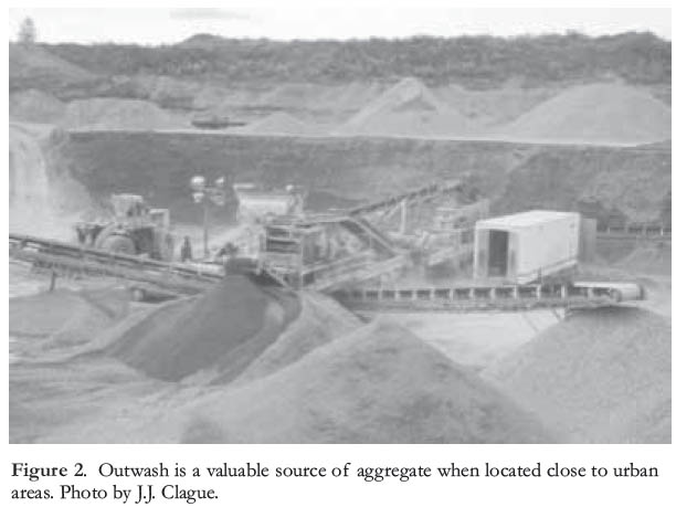
GEOLOGY OF CANADIAN CITIES AND THEIR ENVIRONMENTAL PROBLEMS
Locations of Cities in Relation to Geology
10 Canadian cities are situated where they are for a variety of reasons that are not directly geological. Initially, transportation routes, harbours, river crossings, and the availability of water to power sawmills and gristmills were important factors. Later, the discovery of valuable mineral deposits led to the establishment of mining towns, particularly on the Precambrian Shield and in the Cordillera. In the middle to late 19th century, railway construction catalyzed the establishment and growth of some urban areas.
11 Most Canadian cities are in the southern part of the country because of the more favourable climate and proximity to agricultural land (Fig. 1). The relatively thick glacial deposits in southern Canada made for easier and less costly construction. Once established for other reasons, many Canadian cities have had to cope with a variety of engineering and environmental problems arising from the effects of past glaciation.
Urban Resources
12 During the early settlement of Canada, proximity to mineral resources was a valued asset, but as cities grew and required ever larger quantities of raw materials, mining or quarrying operations became objectionable because of their noise, traffic, dust, and air and water pollution. Over time, zoning regulations precluding such land uses came into force, and mining operations moved out of cities. As urban expansion continued, exploitation became too costly because of high land values.
Aggregate
13 Resources that are crucial for urban development – sand, gravel, and crushed stone – have, ironically, been seriously impacted by growth of cities. Exploitation of aggregate has been forced out of cities because of its environmental impacts and competing demands for land. Yet, low unit value and transportation costs economically constrain the distances between an aggregate source and its urban markets. Hence, in the long term, as deposits of cheaper sand and gravel close to cities are exhausted, Canadians will become increasingly dependent on more costly crushed rock. Recent large increases in fuel costs are bound to exacerbate the problem, and recycled building materials likely will increase in value as transportation costs rise.
14 Most of the mined (quarried) sand and gravel in Canada has its source in glacial deposits and reflects the composition of local bedrock. On the Precambrian Shield, mined aggregate deposits are typically coarse-textured, rich in crystalline rock clasts, and lime-free. In contrast, where ice flowed over carbonate rocks and shales, such as on the prairies, in southern Ontario (Dreimanis 1961) and in parts of the Maritime provinces, tills are more clay-rich and commonly contain calcium carbonate. Shale-bearing aggregate in these regions is normally not suitable for concrete.
15 Sand and gravel occur in a wide variety of depositional settings. Vancouver obtains aggregate from late Pleistocene outwash (Fig. 2) and delta deposits, the latter elevated by glacioisostatic rebound at the end of the last glaciation (Mustard et al. 1998). Prairie cities exploit alluvial deposits in major valleys that channelled meltwater from the Laurentide Ice Sheet (Christiansen 1970; Kathol and McPherson 1975; Baracos et al. 1983; Osborn and Rajewicz 1998; Rutter et al. 1998); and large esker complexes are quarried on the Canadian Shield. Thunder Bay also extracts sand and gravel from moraines and deltas formed in high-level glacial lakes (Burwasser 1977; Karrow 1998), and Sault Ste. Marie extracts aggregate from the former beaches of glacial lakes (Cowan 1998). Sudbury uses crushed bedrock from quarries and excavations, as well as crushed slag produced during mineral processing (Burwasser 1979; Rousell et al. 1998; Barnett and Bajc 2002). In southern Ontario, large moraines, such as the Waterloo and Oak Ridges moraines, and glacial-lake spillways (Chapman and Putnam 1984) are important sources of sand and gravel. Marine deltas built into the Champlain Sea are sources of aggregate in the St. Lawrence Valley. Cities in Atlantic Canada use glaciofluvial gravel, sediment dredged from the seafloor, and crushed bedrock to meet their aggregate needs (Lewis et al. 1998; Catto and St. Croix 1998).
Clay and Shale
16 Clay was once widely used in the manufacture of brick in Canada. The major sources were glaciomarine sediments along the Pacific and Atlantic coasts and in the St. Lawrence Valley, and glacial-lake sediments in the Toronto area.
17 The Don Valley Brickyard in Toronto is world-famous for its exposures of fossiliferous interglacial sediments. The pit was opened about 1890 in glacial-lake clays; in subsequent years, Ordovician shale below the Quaternary deposits was exploited. Initially located outside Toronto, the brick-yard was closed in 1984 because it had become surrounded by the city, blocking expansion (Kelly et al. 1987). The Haney brickworks in Vancouver has a similar history. It produced brick and clay tile from Pleistocene glaciomarine clay, but closed in the 1970s after being surrounded by suburban development and because of market loss to tile made from hydrocarbons (Mustard et al. 1998).
18 Manufacture of clay products is much affected by clay mineralogy (Grim 1962), which is largely controlled by local bedrock and glacial history. Clays found on the prairies are derived from the underlying smectite-rich Cretaceous shales. Smectite and montmorillonite constitute a group of clay minerals that adsorb water and ions when wetted and exert large forces that can damage structures built on them. This swelling property also makes prairie clays unsuitable for brick manufacture – Cretaceous clays used for this purpose in southern Manitoba in the 19th century generally produced poor quality brick (Bannatyne 1967).
Water Supply
19 Water differs from most minerals in being a renewable resource and a fluid; it is also the most important resource for any urban area. Water-bearing rocks or sediment (aquifers) are an important source of drinking water for many Canadian cities (Fig. 3). The Waterloo region, for example, is dependent on groundwater for most of its supply, and is the largest urban area in the country to do so. Many buried paleo-valleys in Canada comprise thick out-wash and alluvial gravels that contain abundant groundwater. Mapping of these valleys using well data, supplemented by drilling and geophysics, is a priority in many groundwater exploration programs.
20 The water used in most cities in southern Ontario and on Canada’s east and west coasts comes from surface bodies such as lakes, rivers, and storage reservoirs (Catto and St. Croix 1998; Lewis et al. 1998; Mustard et al. 1998; Nasmith and Buck 1998). London, for example, is supplied by a pipeline from Lake Huron. Since 1919, Winnipeg has obtained most of its water from Shoal Lake, an embayment of Lake of the Woods 156 km to the east. Other cities on the prairies depend either on river water or on groundwater extracted from glacioflu-vial deposits in surface or buried valleys.
21 Unconfined aquifers, which lack a relatively impermeable seal, are vulnerable to contamination from the surface by industrial and agricultural waste, whether they are hosted by bedrock or sediment. In Ontario, two widely publicized events in recent years at Elmira, 15 km north of Waterloo, and Walkerton, 75 km southwest of Owen Sound, underline the vulnerability of unconfined aquifers. Elmira, with a population of about 12 000, has several chemical industries that contaminated the town’s water supply in 1990, forcing closure of municipal water wells and their replacement with a pipeline from Waterloo (Xiang et al. 1996). A decade later, contamination of the Walkerton water supply with E. coli from farm runoff caused seven deaths and hundreds of illnesses. An inquiry estimated the cost of the Walk-erton disaster at over $60 million, including hydrogeological investigations, provision of temporary bottled water, loss of business, legal fees for the Ontario government, and lowered real estate values (Howard 2006). The Ontario government was found partly responsible because of their decision to deregulate water testing and reduce funding to the Ministry of the Environment during the 1990s. The Walk-erton incident brought major changes to government, including strengthening of the Ontario Geological Survey and a renewed mandate to document the geology of southern Ontario.
Waste Disposal
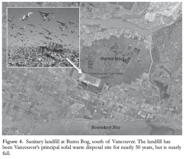
22 Gore (2006) has reviewed the problems of waste in modern urban society. Liquid human waste is dealt with in sewage treatment plants, whereas solid waste is mainly disposed of in sanitary landfills (Fig. 4). Sewage treatment is largely a chemical engineering process with little geological involvement, although floods can overwhelm treatment plants, causing downstream contamination. However, sanitary landfills have an intimate connection with geology, as the placement of waste disposal sites requires knowledge of the extent, lithology, and properties of underlying earth materials.
Figure 3. Schematic diagram of a valley fill comprising unconsolidated sediments with both confined and unconfined aquifers (Turner et al. 1996).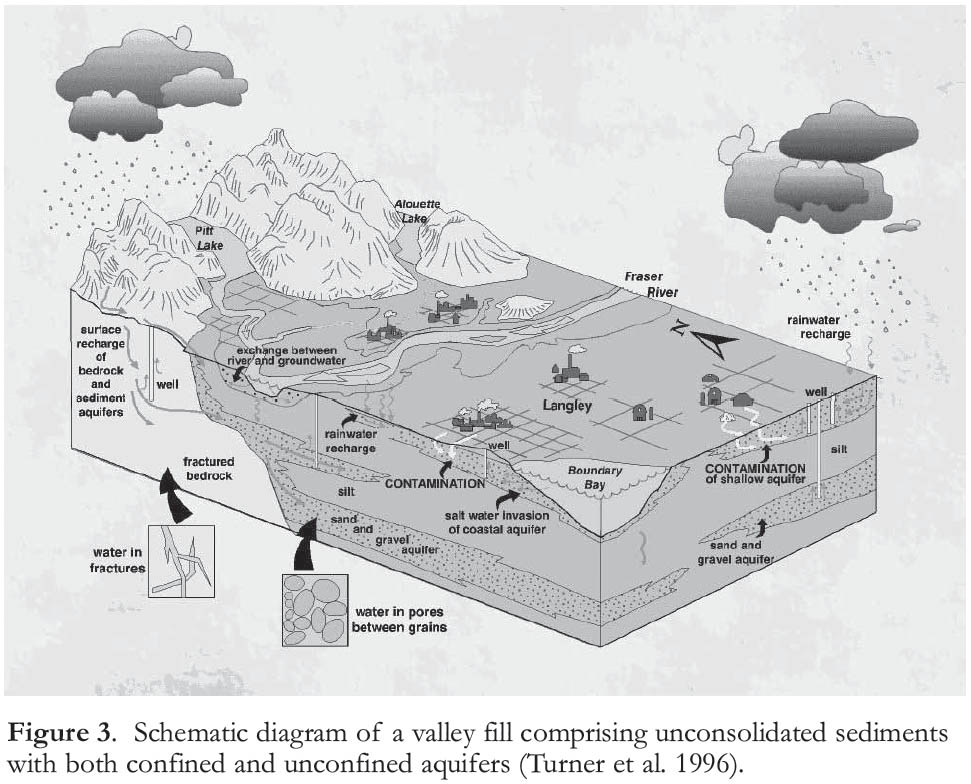
Display large image of Figure 3
Display large image of Figure 4
23 Solid waste disposal has become a major problem for Canadian cities, driven by urban growth, a dramatic rise in product packaging, ‘planned obsolescence’ of products, and our ‘throw-away’ mentality. The problem has spawned successful programs to recycle waste, e.g. ‘blue box’ programs in most Canadian cities, garden waste recycling initiatives, and legislated limits on household waste disposal.
24 Toronto has one of the greatest solid waste disposal challenges in Canada. For several years, the Greater Toronto Area exported large quantities of waste to Michigan, but recent restrictive laws there are stopping the flow, so a temporary site has been found near London, Ontario. A proposed solution that was later rejected was to ship waste by rail to former mines in northern Ontario. Given ongoing waste generation and the political turmoil it causes, novel ideas for waste disposal are likely to arise repeatedly in the future. Interestingly, the potential financial gains have inspired competition to store solid waste, although environmental concerns always pose practical problems.
25 Disposal of waste produced by personal and industrial activities may contaminate water supplies. Many landfills are located in a permeable medium such as sand and gravel, with an impermeable base such as till, and a low-permeability cap commonly derived from till. Pits left by extraction of sand and gravel readily attract proposals to fill the unwanted, unsightly holes with garbage – a symbiotic relationship between the aggregate and waste disposal industries. In such cases, it is important to install monitoring systems to track the possible spread of contaminated fluids leached from the waste.
26 Some former landfills were constructed directly on the existing natural land surface and now form anomalous hills that are sometimes used for recreational purposes. Leachate plumes that require detailed study and remediation have formed at and near many older sites, and at some sites, decay of organic waste generates considerable methane, some of it usable as a fuel. Of some 800 landfill sites across Canada, 41 capture greenhouse gases and 16 of these use methane in various industrial processes. Only Montreal, Toronto, Waterloo, and Edmonton use it to generate electricity. Methane produced at a Waterloo landfill is used in an onsite power plant to produce energy that is fed into the provincial grid; in eight years of operation, nearly 165 million m3 of methane have produced over 250 million kilowatt-hours of electricity.
Construction Problems
27 Complexity is the norm in Pleistocene glacial deposits; glacial materials typically change markedly, even abruptly, both laterally and vertically, and thick drift deposits commonly comprise interbedded glacial and non-glacial sediments. Site investigation is essential and has become routine prior to site development. Natural earth materials have distinct characteristics related to location and geological history, and these characteristics commonly control the use of these materials and the human activities that occur on and in them. For example, Leda Clay, deposited in the Champlain Sea during retreat of the Laurentide Ice Sheet 12 000 years ago, underlies parts of several major cities in the St. Lawrence Lowland, including Ottawa, Montreal, and Québec City. Leda Clay is ‘sensitive’ and may liquefy when disturbed or settle irregularly when loaded. Crawford (1953) describes a classic case of severe, even dangerous, differential settlement of the National Museum of Canada in Ottawa. Constructed in 1900 with an asymmetrical design featuring a heavy stone tower on one side, the structure became so severely distorted that the tower was removed, allowing more balanced settlement and stability. The high sensitivity of Leda Clay is attributed to deposition of fine glacial rock flour by flocculation in high-cation marine waters of the Champlain Sea. The platy clay particles are weakly bound to one another; when disturbed, the ‘house of cards’ structure collapses and grains become supported by inter-stitial water, leading to rapid flow of the liquefied sediment. Similar glaciomarine sediments are found on the west coast, but they are not as sensitive as Leda Clay, and consequently fewer problems have arisen. However, large liquefaction-induced failures of glaciomarine sediments occurred at Haney, a suburb of Vancouver, in 1880 (Evans 2001; Clague and Turner 2003) and near Terrace, BC in 1993 (Geertsma et al. 2006).
28 Clay-rich sediments derived from smectite-bearing Cretaceous shale have been responsible for extensive landsliding and building settlement in the prairies. Some clays contain up to 50% smectite, and markedly expand and shrink with moisture change, causing damage to buildings with shallow foundations. When the newly-built Transcona grain elevator in Winnipeg was first loaded in 1913, the strength of Lake Agassiz clays at that site was exceeded and the structure collapsed (Peck and Bryant 1953). Similar construction problems exist throughout the Red River Valley of Manitoba, as well as in other Canadian urban areas underlain by Lake Agassiz clays. Riverbank failures along the Red River are induced by excess pore water pressure and loss of strength when Lake Agassiz clays become saturated during high river levels (Baracos et al. 1983).
29 Construction can be challenging in cities with irregular bedrock surfaces, such as hilly Victoria and Sud-bury, and in areas of complex Quaternary stratigraphy such as the Greater Vancouver area. Buried bedrock valleys may also complicate foundation conditions, with higher loading capacities on valley flanks and lower ones on valley fills. Tills, ice-contact stratified drift, and proglacial water-lain deposits may contain large boulders, which complicate pile-driving and excavation.
30 Glaciation has affected foundation materials in other ways; for example, the load of a glacier consolidates overridden sediments, increasing their strength and reducing their compressibility (Harrison 1958). Lodgment till is the classic ‘preconsolidated’ sediment (Karrow 1988a), but all sediments overridden by ice are affected. In contrast, late-glacial and postglacial sediments have not been consolidated by overriding ice and may be unstable on slopes or may settle and consolidate when built upon. A classic example of sediment consolidation is the differential settlement of the Empress Hotel in Victoria, BC (Crawford and Sutherland 1971). Opened in 1908, the hotel’s west end was constructed on solid bedrock, but its east end was underlain by fill that covered glaciomarine clay. Severe differential settlement resulted, which required extensive costly renovation in 1966.
31 A process that causes much damage to roads, buildings, and other structures across Canada is cyclic freezing and thawing of water in the pores and fractures of sediments, rocks, and construction materials. Forces generated by repeated expansion and contraction of water on natural earth materials, concrete, asphalt, and building stone may be sufficient to cause failure. The cost to highways is considerable, and is greatest where freeze-thaw cycles are most frequent. Southern Ontario, for example, has more freeze-thaw cycles than Winnipeg and Yellowknife, where temperatures do not cross the freezing mark as many times each year.
GEOLOGICAL HAZARDS
32 Canada is exposed to every natural hazard on Earth. Although all parts of the country experience natural hazards, urban areas are most vulnerable to loss because of their concentrations of population, commercial and industrial activity, large buildings, and infrastructure. Some of the most serious hazards in its urban environments are meteorological and beyond the scope of this paper. The classic, first-order geological hazards include earthquakes, tsunami, volcanic eruptions, landslides, flooding, and sea-level rise. Recent papers by Clague and Bobrowsky (2010), and Cassidy et al. (2010) have discussed, respectively, Canadian geological hazards in general and earthquakes specifically, hence this section has been abbreviated and the interested reader is referred to those articles.
Earthquakes
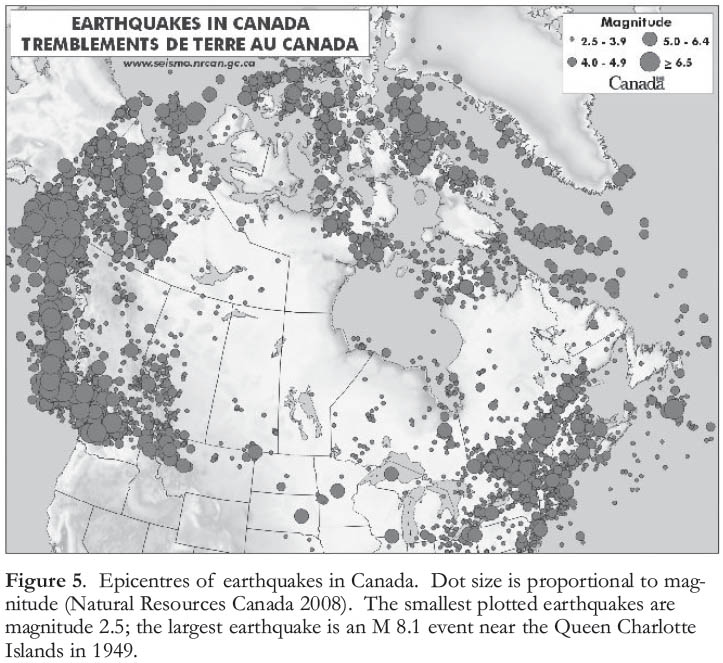
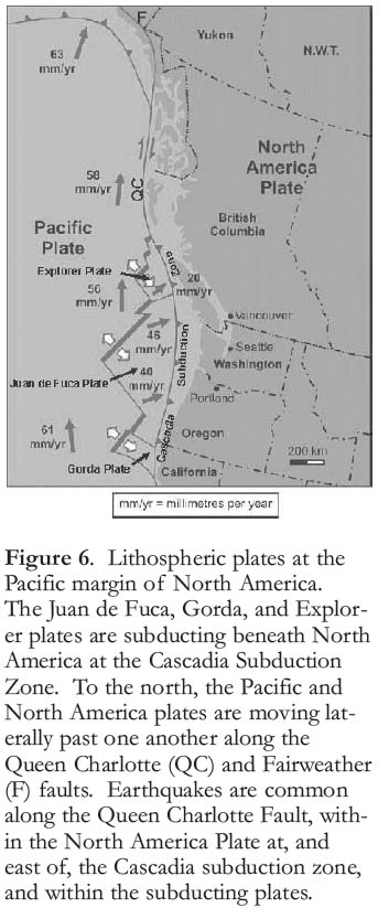
33 The area at greatest risk from earthquakes in Canada is the west coast (Clague et al. 2005; Fig. 5), as three plates, the Juan de Fuca, Pacific, and North American, meet at the Cascadia subduction zone (Fig. 6). Fortunately, most earthquakes on Canada’s west coast occur beneath the Pacific Ocean floor, far from cities (Rogers 1994). Although some of these quakes are large, they pose little threat to people and property. Other earthquakes, however, are closer to the cities of the south coast – beneath Vancouver Island, the Strait of Georgia, the southern mainland of British Columbia (BC), and Puget Sound and the adjacent lowland. Earthquakes that threaten Vancouver, Victoria, and other cities on the south coast are of three types (Rogers 1994).
- Earthquakes within the North American Plate. The hypocentres of this group of earthquakes are less than 20 km below the surface. On average, there is one such earthquake in BC every day; nearly all are too small to be felt, but a potentially damaging one occurs about once every ten years or so. The largest in the past century was a magnitude (M) 7.3 earthquake in 1946 on central Vancouver Island (Rogers and Hasegawa 1978). A crustal earthquake of this size with an epicentre less than 50 km from Victoria or Vancouver would be catastrophic, causing tens or hundreds of billions of dollars in damage (Munich Reinsurance Company of Canada 1992).
- Earthquakes within the subducting Juan de Fuca Plate. These earthquakes have sources as deep as 80 km below the surface and occur beneath Puget Sound and the southern Strait of Georgia; several deep quakes have caused much damage in the Puget Sound region, including one near Olympia, Washington, in February 2001.
- Subduction earthquakes. These rare, large earthquakes originating on the thrust fault bounding the converging North American and Juan de Fuca plates are among the largest on Earth, and have possible magnitudes up to 9.5. There is abundant geologic evidence for many such earthquakes in the past few thousand years (Atwater et al. 1995, 2005; Satake et al. 1996; Atwater and Hemphill-Haley 1997; Clague 1997), most recently in January 1700. Geophysical measurements show that energy is now accumulating towards the next megathgrust earthquake – Vancouver Island is rising and contracting above the descending Juan de Fuca Plate, as would be expected if the two plates locked and were not moving smoothly past each other (Dragert et al. 1994).
Display large image of Figure 5
Display large image of Figure 6
34 Earthquakes up to about M 7 in southern Ontario and southern Québec (Adams and Basham 1991; Fig. 5) are associated with an ancient rift structure that extends along the St. Lawrence River Valley from Montréal to Sept Iles, Québec. Similar rift structures occur along the Ottawa and Saguenay river valleys. Earthquakes have occurred historically in three clusters in this region at depths of 5 to 30 km – one in eastern Ontario and western Québec (magnitudes up to 6.2), a second around Charlevoix, northeast of Québec City (magnitudes of 6 to 7), and a third in the lower St. Lawrence region near Baie-Comeau, Québec, consisting of mostly small earthquakes (Adams and Basham 1991). Most cities in Ontario and Québec are not at great risk from earthquakes, although a moderate quake in the Ottawa, Montréal, and Québec City areas cannot be precluded. A concern is that the older masonry buildings in these cities would be highly vulnerable to damage during even moderate (M 6) earthquakes.
Tsunami
35 Earthquakes at subduction zones off Kamchatka, Japan, the Aleutian Islands, and the west coast of North America are the main sources of tsunami that reach Canada’s west coast (Clague et al. 2000). Many communities on Vancouver Island were damaged by the tsunami triggered by the M 9.2 Alaska earthquake of Friday, March 27, 1964 (Wigen and White 1964; Murty and Boilard 1970; Thomson 1981). A great earthquake at the Cascadia subduction zone poses the biggest tsunami threat to coastal British Columbia (Clague et al. 2000). The threat is greatest to communities on western Vancouver Island and, to a lesser extent, Victoria. Vancouver likely would be spared because the tsunami’s energy would greatly decrease as the waves moved through Juan de Fuca Strait and the narrow waterways of the southern Gulf Islands.
36 Landslides that plunge into the sea, or that occur on the ocean floor, can also trigger tsunami, particularly in fiords indenting the British Columbia coast. At Kitimat, in 1975, a large submarine landslide in Douglas Channel produced waves up to 8 m high that caused about $2 million damage to shore facilities (Murty 1979).
37 The risk of tsunami is also present on the east coast of Canada – in November 1929, an M 7.2 earthquake occurred on the ocean floor at the mouth of the Laurentian Channel between Nova Scotia and Newfoundland, triggering a submarine landslide and initiating a tsunami (Heezen and Ewing 1952; Piper et al. 1988; Fig. 7). Although damage and loss of life was confined to the sparsely populated Burin Peninsula in Newfoundland (Clague et al. 2003), a minor tsunami hazard must be acknowledged for the larger Atlantic Canadian urban areas of Halifax and St. John’s.
Volcanic Eruptions
38 In Canada, active volcanism is restricted to British Columbia and southwest Yukon. There are about 150 volcanoes in this region that are young in a geologic sense, having erupted one or more times during the past two million years (Souther 1977, 1992). The only Canadian city at risk from a volcanic eruption is Vancouver; this threat arises from the Mount Baker stratovolcano 100 km southeast of Vancouver in the state of Washington (Hickson 1994; Fig. 8a). Mount Baker has erupted several times in the past 10 000 years, most recently in 1843 (Scott and Tucker 2003). Venting of gases and hot fluids from the summit crater in the 1970s provided a timely reminder that the volcano is still active and could erupt again with damaging effects. Although prevailing winds in southwestern BC are toward the east, a large ash plume from Mount Baker (Fig. 8b) poses some risk to Vancouver; heavy ash fall can collapse buildings, and even minor amounts of ash may make breathing difficult and damage crops, electronics, aircraft, and machinery.
Figure 7. Aftermath of the 1929 tsunami in Lord’s Cove, an outport on Burin Peninusula, Newfoundland. Photo by Harris M. Mosdell, from the collection of W.M. Chisholm; provided by A. Ruffman.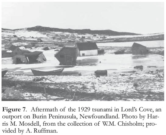
Display large image of Figure 7
39 Lahars are another type of flow that commonly occurs during explosive eruptions of stratovolcanoes. Hot pyroclastic debris mixed with water, forming large, fast-moving muddy flows containing boulders and trees that move rapidly downslope, can destroy bridges and other structures far from the volcano in the valleys down which they flow. The town of Sumas, near the border in the eastern Fraser Valley could be impacted by a lahar flowing down the Nooksack River valley (Clague and Turner 2003).
Landslides
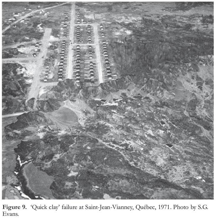
40 Landslides – downslope gravitational movements of sediment and rock – are among the most widespread geological hazards in Canada (Evans 2001); any type of rock can fail if the slope is steep enough or if it is saturated with water. Landslides are most common in mountainous terrain (i.e. BC, Yukon, and Alberta), but also occur in areas of lower relief such as along roadways and river bluffs. They also occur locally in the Appalachian provinces of Québec and New Brunswick; in the St. Lawrence Valley, where many slopes are developed in Leda Clay (Fig. 9); and the valleys of large rivers that cross the prairies. Earth materials particularly prone to landsliding include silts and clays deposited in former glacial lakes and on former marine plains now elevated above sea level.
Flooding
41 Every province and territory in Canada experiences floods on a regular basis, and the damage and loss of life have been considerable. Floodwaters have killed over 200 people and caused several billions of dollars in damage in the country since 1900 (Brooks et al. 2001; Geological Survey of Canada 2007). The major urban areas of greater Vancouver, BC and Winnipeg, Manitoba are susceptible to floods along the lower Fraser River and Red River, respectively. A flood in the lower Fraser River valley in May and June 1948 breached protective dykes at more than a dozen places, inundating some 220 km2 of agricultural land, nearly one-third of the entire floodplain. Sixteen thousand people were evacuated, 2000 homes were damaged, and 82 bridges were washed away. Total losses amounted to more than $20 million (about $200 million in today’s dollars; Brooks et al. 2001).
Figure 8. a) Mount Baker, an active stratovolcano, located about 100 km southeast of Vancouver. Photo by J. Scurlock. b) Hazards associated with eruptions of stratovolcanoes (modified from Meyers and Driedger 2008).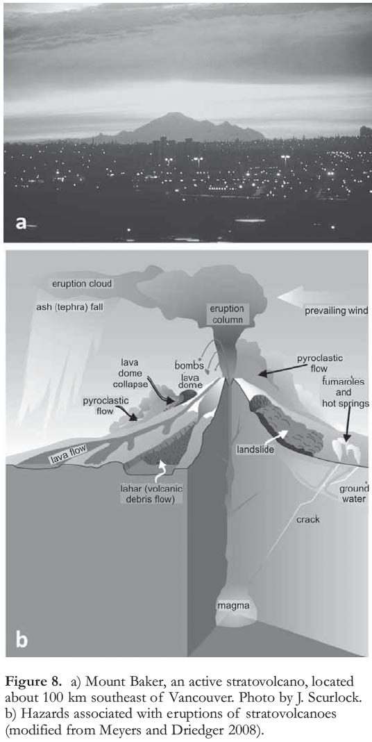
Display large image of Figure 8
Display large image of Figure 9
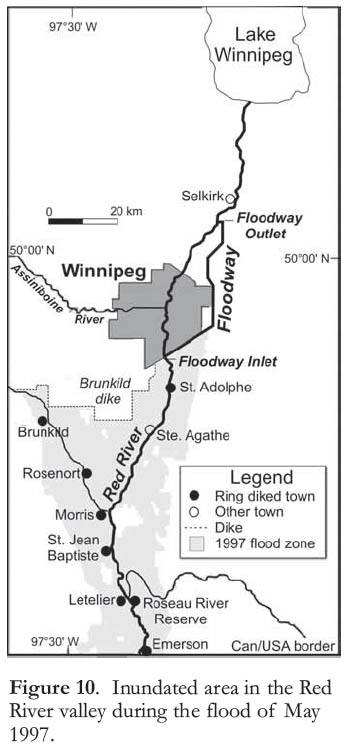
Display large image of Figure 10
42 In the spring of 1997, the Red River spilled across the broad lowland of the glacial Lake Agassiz plain in Manitoba and North Dakota, inundating it to depths of several metres (Fig. 10). Over 7000 military personnel were mobilized for 36 days to assist in strengthening dykes and in relocating nearly 25 000 evacuees. Many communities were under water or cut off, but Winnipeg was not flooded because the Red River Floodway, constructed at considerable cost after a similar flood in 1950, routed the peak flows around the city. Three people drowned and total damage was $815 million (Brooks et al. 2001). Geology plays an important role in Red River flooding. Most of the valley is underlain by low-permeability, glacial Lake Agassiz clays, so surface waters infiltrate the ground slowly. Furthermore, the gradient of the river is low and, in fact, is decreasing because of isostatic rebound – the land is rising more in the north, which is the direction the Red River flows, than in the south. The decrease in the river’s gradient makes it progressively more difficult for the channel to contain flood waters (Brooks et al. 2001).
43 Smaller urban centres such as Chicoutimi, Québec and Fredericton, New Brunswick (repeatedly) have also experienced devastating floods. The worst flood in Québec’s history affected the Saguenay-Lac-Saint-Jean region in July 1996 (Brooks and Lawrence 2000). Following two weeks of constant rain, including 27 cm within a few hours on July 19, over 2 m of water ran through parts of Chicoutimi and La Baie, completely levelling an entire neighbourhood. More than 16 000 people were evacuated, ten people died, and over 2600 homes and cottages were destroyed; total damage exceeded $800 million.
Sea-Level Rise
44 Sea level currently is rising at a rate of about 2 mm per year because of melting of glaciers and heating and thermal expansion of upper ocean waters (Nakado and Inoue 2005). Climate modellers forecast that the sea will be at least a few tens of centimetres higher at the end of the century than today (Intergovernmental Panel on Climate Change (IPCC) 2007), which would increase coastal erosion and threaten low-lying areas with flooding. A global sea-level rise of 1 m would be catastrophic to some low-lying island countries, but no coastal country, including Canada, would be unaffected. Several hundred thousand Canadians live in communities that are less than 2 m above sea level along the shores of the Strait of Georgia and Juan de Fuca Strait (Fig. 11). Significant and extremely expensive defensive works would be needed to protect people and infrastructure in these areas. Likewise, low-lying parts of the Maritime Provinces are vulnerable to sea-level rise. British Columbia and the Maritime provinces will have to choose between making very substantial investments to control coastal erosion and flooding, or else allow beaches and estuaries to migrate landward over wide areas, forcing some relocation of people.
Figure 11. Richmond, British Columbia. This rapidly growing city is less than 2 m above mean sea level and is protected from flooding by sea and river dikes. Photo by J.J. Clague.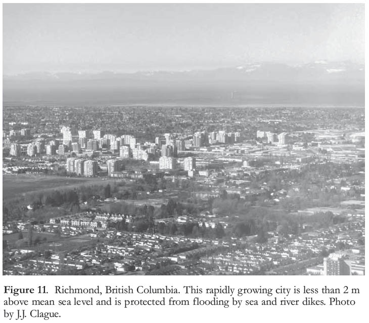
RECENT EVENTS AND THEIR IMPLICATIONS FOR CANADIAN CITIES
Petroleum and Climate
45 This paper has so far dealt with conventional or traditional aspects of urban geology. Here we consider some of the evolving economic and societal influences that may affect urban areas in Canada in the future. These influences overlap or interplay to some extent, but all relate to urbanization and industrialization, which have driven societal and cultural change over the past two centuries. Importantly, urbanization in Canada and all other countries has been accompanied by a perception among city dwellers that they are detached from Earth support systems. Surprisingly few people who live in cities realize that they depend on minerals and hydrocarbons. Nor do they realize where their food and water come from or where their waste goes.
46 Most Canadians now accept the IPCC conclusion that human activity, specifically land clearing and burning of fossil fuels, is raising the surface temperature of the Earth (IPCC 2007). A local ‘heat island’ effect, related to urbanization, is superposed on a complex pattern of regional warming, which is greatest at high latitudes and high elevations. For example, warming in the Canadian Arctic over the past century has been much more pronounced than at mid-latitudes where most Canadians live. Rising temperatures are projected to result in more severe and prolonged droughts in some areas, more rainfall in others, more frequent and violent storms, a reduction in snow and ice cover, rising sea level, and stress on ecosystems. Events are outrunning model forecasts, as demonstrated by the temporary opening of a Northwest Passage through the Canadian Arctic during the summers of 2007 and 2008 (Giles et al. 2008). Many recent books have dealt with these issues (e.g. Flannery 2005), and some have offered solutions (Brown 2007; Monbiot 2007).
47 Global warming is, of course, linked to population growth and industrialization. Coal, then oil, powered the Industrial Revolution; society, as we know it, would not be possible without oil and natural gas. Petroleum geologist M.K. Hubbert accurately predicted that peak oil production in the United States would occur in 1970. Similarly, Deffayes (2001) predicted that world oil production would peak as early as 2004, whereas others think we are now at the peak. The impact of shrinking oil supply on society and cities has been described by Kunstler (2005). One such impact is that asphalt, plastics, and many other products will become much more expensive as the production of oil and gas decreases and demand rises; currently, world consumption of fossil fuels continues to rise. The continued and increasing demand for oil is now impacting world food supplies because of the growing diversion of crops to produce fuel substitutes (‘biofuels’) such as ethanol.
Urban Planning
48 Deprivations of World War II, including food and fuel rationing, triggered exuberant suburban growth throughout North America in the late 1940s, after peace was restored (Kunstler 1993; Greene 2004). However, the end of the war was simply a boost to a trend that was underway in the first half of the 20th century, and that continues today – personal transportation by car (Kay 1997). Car and truck transportation allowed cities to sprawl. Decentralization led to the decay of city cores, serious air pollution, and growing urban social and economic problems. Cheap oil led to the expansion of the US and Canadian highway systems and the proliferation of a labour-intensive and energy-inefficient transport system, namely truck transport. However, the growth of Asian economies and approaching peak oil led to increases in the cost of gasoline and diesel fuel. How will cities adjust as commuting by car becomes prohibitively expensive and large numbers of people relocate to be closer to work and shopping? Cities will have to be extensively reorganized and reconstructed, with satellite centres, higher population densities, vertical growth, and transformation of space currently reserved for the automobile to better meet human needs. Nascent changes are already underway in Vancouver, Toronto, and other Canadian cities, and can be expected to accelerate over the next several decades. These changes will require that we acquire a much better understanding of the geology of Canadian cities than we currently have, as explained in the following sections.
Underground Construction
49 Cities must deal with subsurface materials and conditions in providing many of their services – water, sewage, electricity, gas, telecommunications, and subways. Durand and Boivin (1985) outline the many ways in which underground space is used and its potential for major expansion in Canada. Reeves and Palassio (2008) describe parts of Toronto’s underground water system. All forms of underground construction involve earth materials and require knowledge of geology, but as yet there is no organized system of recording what is found in borings and excavations in Canadian cities. In most Canadian cities, knowledge of the sub-surface gleaned from the diverse activities of city development remains scattered and dispersed (Karrow 1988b; Karrow and White 1998).
50 In the late 20th century, a few individuals chose to construct houses underground, building down rather than up, to take advantage of the equable and uniform temperatures below the surface and therefore save on heating and cooling costs. As energy costs continue to rise, more interest in underground housing may develop, and commercial interests have already taken advantage of the benefits to be gained from underground development. In Toronto (see White 1982 for an early portrayal), 27 km of tunnels connect shopping, services, and entertainment in the downtown core, which has done much to revitalize downtown Toronto. Promoters cite convenient links and protection from winter snow and cold and summer heat. Montreal too has an extensive underground development (see Durand and Boivin 1985 for an early portrayal). These commercial developments were carried out for economic reasons, but they have social and environmental benefits, and further extensions are planned. There are energy savings from underground habitation and work, in contrast to our present system of aboveground buildings, which maximizes surfaces through which energy is lost. Building size is an additional factor – one large building is more energy efficient than a dozen small ones. Except for shopping malls, most suburban commercial developments show a lack of concern about energy efficiency, with separate buildings for banks, drug stores, drive-ins, variety stores, and many other services. Examples of underground cities that may exist in the future are given by de Mulder and Kraas (2008).
Geothermal Energy
51 Canadians consume energy at about five times the global average and thus have the impact of about 160 million people. Anything that can be done to reduce our energy consumption is to be applauded. Geothermal energy, although not a complete solution, is a promising avenue to pursue.
52 Canada has large, untapped geothermal resources, including deep, high-temperature resources and shallow, low-temperature ones. Canada’s deep geothermal resources are mainly in the western part of the country; to date, this resource is undeveloped, but plans are being made to develop the geothermal field at Mount Meager in southwestern British Columbia. In contrast, the shallow-geothermal-energy business is growing rapidly. Heat pumps use water from relatively shallow wells to heat and cool homes and offices. A $200 million project initiated in Toronto in 2004 uses cold (4°C), deep, Lake Ontario water (part of Toronto’s regular water supply) to cool downtown office buildings. It is claimed that electrical consumption has been reduced by 90%, with equivalent reductions in CO2 emissions. Provincial- and federal-funded geophysical surveys of ground-heat flow are underway, the results of which will form an important foundation for resource exploitation. A recent workshop report sets out the present status of deep energy resources for western Canada (Lebel 2009).
EDUCATION
53 The topic of education has two aspects: specialist training for those undertaking a career in urban geology, and public education for the 80% of the population living in urban areas (Robinson and McCall 1996).
Professional Training
54 Urban geology is not a specialization recognized in university curricula, but a few individuals have made efforts to offer courses or programs in this field. Urban geology shares much content with environmental geology and engineering geology, for which courses and programs are offered more widely, but neither is directed specifically to urban environments. Urban geology courses or programs were formerly offered at Indiana University, the University of Nebraska, Brock University, and Laurentian University. At present, none of these offerings is active. As individuals retired or died, institutions did not follow up; the offerings only reflected the initiatives of interested individuals.
55 The content of a degree program in urban geology should be rooted in basic geology and include courses in mineralogy, petrology, stratigraphy, sedimentology, geochemistry, geomorphology, and Quaternary geology. To distinguish it, and to provide the tools needed for a broad-based assessment of urban geoscience and geo-environmental issues, an urban geology program must also include applied aspects of geology such as hydrogeology, engineering geology, and resource management, and courses in landscape and urban planning, law, geographic information systems, ecology, drilling and excavation technology, urban organization and administration, and urban politics and economics. These courses should be a senior specialization, following a solid grounding in geology. There will have to be negotiated compromises in core and specialized courses to produce graduates eligible for professional registration, now required in all provinces. Perhaps the space and time required could be realized with a course-work masters program – a single-year upgrade beyond the B.Sc. level.
56 Current global conditions, outlined above, suggest that cities will reorganize themselves in the near future, requiring considerable planning and, among other things, geological knowledge. It is the right time for universities to begin to offer courses and programs in urban geology. The literature on urban planning is large, but only a small subset deals with the geological context; a few examples include Howard and Remson (1978), Cooke and Doornkamp (1990), Marsh (2005), and Fabos (1985), of which the last is particularly good in preparing geologists to work with planners.
Public Education
57 All scientists struggle with the reality of public ignorance of their discipline, and earth scientists are no exception. With public concerns about climate change and rising fuel costs, earth scientists have an opportunity to capture the attention of the public and politicians. Naturalist groups are already sensitive to environmental issues, whereas most city dwellers have insulated themselves from nature, preferring artificial environments and entertainment. Geologists need to be more proactive in explaining to friends, family, neighbours, the public, and, in particular, to politicians and policy makers how geology is integral to their everyday lives. The International Year of Planet Earth Outreach program has attempted to do this at the local, national, and international levels.
58 Educating the public requires that information be made available in an attractive way. The information must address practical needs of people, as well as satisfy their curiosity about the environment. Geology can be linked to archaeology and climate, which already have the public’s interest; fantastic animals that are now extinct, such as dinosaurs and mammoths; and scenic splendours, such as mountains and coastal scenery, many embodied in our national parks. The Geoscape program of the Geological Survey of Canada (Clague et al. 1997) is a good recent example of a public educational tool, as most of the content is in urban areas, as is A.V. Morgan’s new 4.5 km Geo Time Trail on the Waterloo Moraine (Nowlan 2008). A beautiful new book on the geology of Canada, targeting the general public, will be published soon. The public education effort has to be a broad one, grounded in cooperation among primary and secondary schools, universities and colleges offering courses and workshops, museums, and federal and provincial geological surveys. Some cities offer walking tours that emphasize local history, but could well incorporate geology. Some people believe that building stones are the only things geological in a city, although Canadian cities such as Victoria, Sudbury, Hamilton, Québec City, Saint John, and Halifax have much bedrock outcrop to examine. Vancouver and Toronto have prominent shore cliffs to feature. Reeves and Palassio (2008) report a growing number of citizen groups interested in Toronto’s buried urban valleys. In any city, tall buildings, service pipelines, and water wells penetrate subsurface rocks and sediments, and there is always a story to be told (Edwards 2009). What are the engineering materials and geological problems at a particular construction site? What is the evidence for former seas and glacial lakes? How do we know the ages of events and rocks from the geological past? Examples are endless, and geology in the form of rocks, sediments, and topography is readily visible and at our fingertips in every city.
59 Of course, reaching the public would be much easier if more people were exposed to geology in elementary and secondary school. Taking a course or even a degree in geology should be an attractive option for students not specifically interested in a career in geoscience. Everyone should be encouraged, if not required, to learn a little geology, if for no other reason than to raise their level of awareness and enjoyment of the outdoors.
CONSERVATION OF GEOLOGICAL SITES
60 Related to the need for better public education in geology is the need for more knowledge about the geology of our cities, which is where most people live and work. Important geological sites need to be preserved as part of our geological heritage (Gray 2008; Donaldson 2009). The motivation is similar to that driving preservation of heritage buildings and other tangible evidence of our urban past. It is easier to set aside geological features in remote areas than in a developed urban environment, but preservation of features in a city is a much greater achievement because they benefit far more people. Karrow (1988b) laments the neglect of the Quaternary geology of the Toronto area, focusing on the Don Valley Brickyard exposures of fossiliferous interglacial sediments (Fig. 12), and there are many other examples of loss of key geological exposures in other Canadian cities. Of course, geological sites must be studied before they can be preserved, not only to give the sites higher profiles but also to prepare accurate and authoritative descriptions. Information about protected sites needs to be made available both to local residents and to tourists.
61 Europe has a tradition of greater public interest in history and geology than Canada; ‘Geopark’ have been established in many European countries. However, attitudes in Canada are changing, as shown by Gray (2008) and a new Geoscience Canada series on geoheritage. In November 2009, an application was submitted to UNESCO and the Global Geoparks Network in a bid to create the ‘Stone-hammer Geopark’ in the Saint John region of southern New Brunswick (Miller 2009). If approved, Stonehammer will be the first Geopark in North America. Another reflection of this change in attitude is the designation of important geological sites as Areas of Natural and Scientific Interest (ANSI) by the Ontario Ministry of Natural Resources. The ANSI sites are widespread across the province and are obligatory considerations in land use. They provide some measure of site protection and are an important starting point in geoheritage preservation. These sites are highlighted so that they are more easily recognized by the public, and the likelihood that their future will be secure is therefore increased (Bennett et al. 1996).
Figure 12. Don Valley Brickyard, Toronto, which produced brick from glaciolacustrine clay and Ordovician shale bedrock. Top: Don Brickyard, July 10, 1985, after purchase by Ontario government. Back-filling of the bedrock quarry is well advanced, with the north face retained for geological study. Bottom: Don Brick-yard, October 14, 2007. Landscaped quarry fill and vegetative growth increasingly obscure the north face. Photos by P.F. Karrow.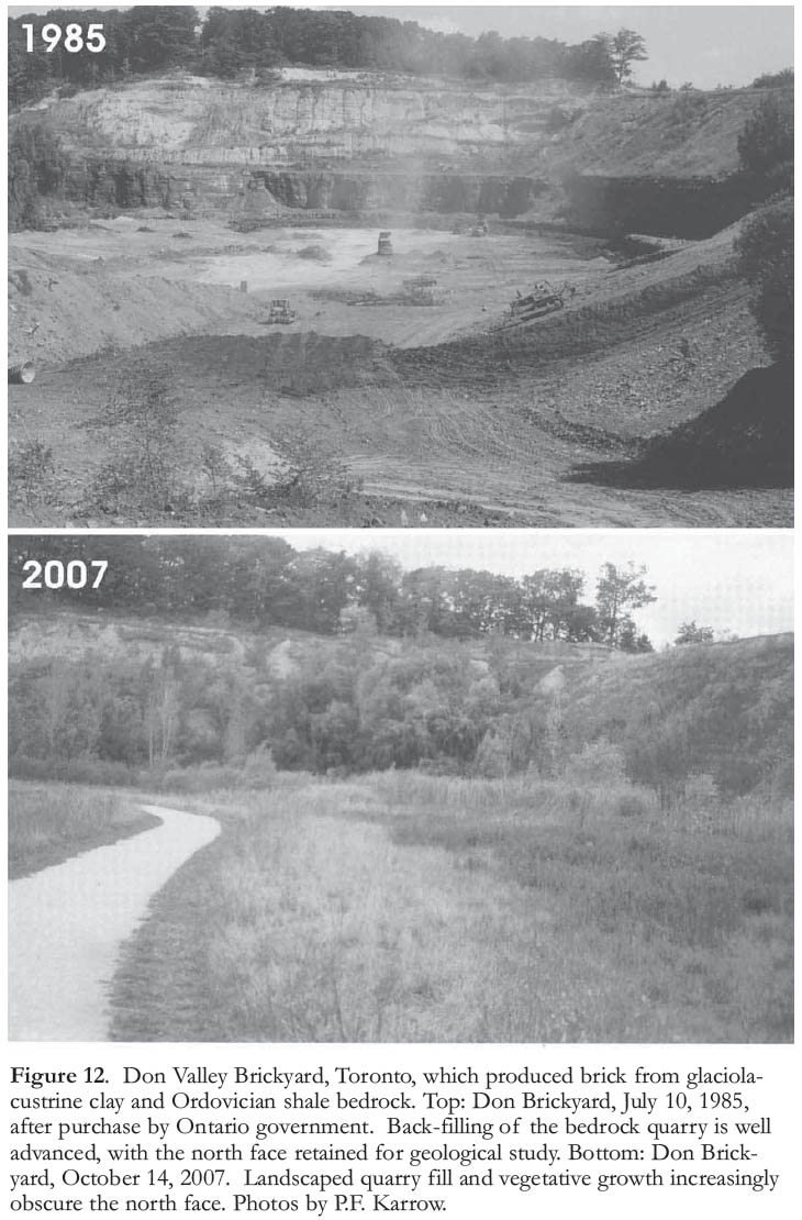
ACKNOWLEDGEMENTS
W.J. Wayne, O.L. White, F.J. McCarthy, and P.J. Barnett provided information on university courses in urban geology. We also acknowledge O.L. White for information on the Toronto PATH underground and the Toronto office cooling system, V. Blair for information on geothermal heat pump systems, D. Boerner and E. Cey for information on heat-flow surveys, J.F. Barker for information on landfill methane generation, and R. Lacombe for information on the Montréal underground. We thank journal reviewers D. Van-Dine and O.L. White and series editors J.T. Teller and R.A. Wilson for their comments, which led to extensive improvement of the paper.REFERENCES
Adams, J., and Basham, P. W., 1991, The seismicity and seismotectonics of eastern Canada, in Slemmons, D.B., Eng-dahl, E.R., Zoback, M.D., and Black-wekk, D.D., eds., The Geology of North America: Decade Map Vol. 1: Geological Society of America, Neotectonics of North America, Boulder, Colorado, p. 261-275.
Ami, H.M., 1900, On the geology of the principal cities in eastern Canada: Transactions of the Royal Society of Canada, Series 2, v. 6, sect. 4, p. 125-173.
Armstrong, J.E., 1956, Surficial geology of Vancouver area, British Columbia: Geological Survey of Canada, Paper 55-40, 16 p.
Armstrong, J.E., 1984, Environmental and engineering applications of the surficial geology of the Fraser Lowland, British Columbia: Geological Survey of Canada, Paper 83-23, 54 p.
Atwater, B.F., and Hemphill-Haley, E., 1997, Recurrence intervals for great earthquakes of the past 3500 years at northeastern Willapa Bay, Washington: United States Geological Survey, Professional Paper 1576, 108 p.
Atwater, B.F., Musumi-Rokkaku, S., Satake, K., Tsuji, Y., Ueda, K., and Yamguchi, D.K., 2005, The orphan tsunami of 1700: Japanese clues to a parent earthquake in North America: United States Geological Survey, Professional Paper 1707, 133 p.
Atwater, B.F., Nelson, A.R., Clague, J.J., Carver, G.A., Yamaguchi, D.K., Bobrowsky, P.T., Bourgeois, J., Darienzo, M.E., Grant, W.C., Hemphill-Haley, E., Kelsey, H.M., Hacoby, G.C., Nishenko, S.P., Palmer, S.P., Peterson, C.D., and Reinhart, M.A., 1995, Summary of coastal geologic evidence for past great earthquakes at the Cascadia subduction zone: Earthquake Spectra, v. 11, p. 1-18.
Bannatyne, B.B., 1967, The clays and shales of Manitoba: Manitoba Geological Survey, Publication 67-1, 200 p.
Baracos, A., Shield, D.H., and Kjartanson, B., eds., 1983, Geological Engineering Report for Urban Development of Winnipeg: University of Manitoba, Department of Geological Engineering, Winnipeg, MB, 78 p.
Barnett, P.J., and Bajc, A.F., 2002, Quaternary geology, in Rousell, D.H., and Jansons, K.J., eds., The Physical Environment of the City of Greater Sud-bury: Ontario Geological Survey, Special Volume 6, p. 57-85.
Bennett, M.R., Doyle, P., Larwood, J.G., and Prosser, C.D., 1996, Geology on your doorstep: The role of urban geology in earth heritage conservation: The Geological Society, London, UK, 270 p.
Brooks, G.R., and Lawrence, D.E., 2000, Geomorphic effects of flooding along reaches of selected rivers in the Saguenay region, Quebec, July 1996: Géographie physique et Quaternaire, v. 54, p. 281-299.
Brooks, G.R., Evans, S.G., and Clague, J.J., 2001, Floods, in Brooks, G.R., ed., A Synthesis of Geological Hazards in Canada: Geological Survey of Canada, Bulletin 548, p. 101-143.
Brown, L.R., 2007, Plan B 3.0; Mobilizing to Save Civilization: W.H. Norton, New York, 398 p.
Burwasser, G.J., 1977, Quaternary geology of the City of Thunder Bay and vicinity, District of Thunder Bay: Ontario Geological Survey, Report GR 164, 70 p.
Burwasser, G.J., 1979, Quaternary geology of the Sudbury Basin area, District of Sudbury: Ontario Geological Survey, Report 181, 103 p.
Cassidy, J.F., Rogers, G.C., Lamontagne, M., Halchuk, S., and Adams, J., 2010, Canada’s earthquakes: ‘The good, the bad, and the ugly’: Geoscience Canada, v. 37, p. 1-16.
Catto, N.R., and St. Croix, L., 1998, Urban geology of St. John’s, Newfoundland, in Karrow, P.F., and White, O.L., eds., Urban Geology of Canadian Cities: Geological Association of Canada, Special Paper 42, p. 445-462.
Chapman, L.J., and Putnam, D.F., 1984, The Physiography of Southern Ontario (3nd edition): Ontario Geological Survey, Special Volume 2, 270 p.
Christiansen, E.A., ed., 1970, Physical Environment of Saskatoon, Canada: Saskatchewan Research Council, Regina, SK, 68 p.
Clague, J.J., 1997, Evidence for large earthquakes at the Cascadia subduction zone: Reviews of Geophysics, v. 35, p. 439–460.
Clague, J.J., and Turner, R.J., 2003, Vancouver, City on the Edge: Tricouni Press, Vancouver, BC, 192 p.
Clague, J.J., and Bobrowsky, P.T., 2010, International Year of Planet Earth 8: Natural Hazards in Canada: Geo-science Canada, v. 37, p. 17-37.
Clague, J.J., Turner, R.J.W., and Groulx, B.J., 1997, Reinventing the geological map: Making geoscience more accessible to Canadians: Geoscience Canada, v. 24, p. 161-172.
Clague, J.J., Bobrowsky, P.T., and Hutchinson, I., 2000, A review of geological records of large tsunamis at Vancouver Island, British Columbia: Quaternary Science Reviews, v. 19, p. 849-863.
Clague, J.J., Munro, A., and Murty, T., 2003, Tsunami hazard and risk in Canada: Natural Hazards, v. 28, p. 433-461.
Clague, J., Yorath, C., Franklin, F., and Turner, B., 2005, At Risk: The Earthquake and Tsunami Threat in the Pacific Northwest: Tricouni Press, Vancouver, BC, 200 p.
Cooke, R.U., and Doornkamp, J.C., 1990, Geomorphology in environmental management (2nd edition): Clarendon Press, Oxford, UK, 410 p.
Cowan, W.R., 1998, Urban geology: City of Sault Ste. Marie, Ontario, in Karrow, P.F., and White, O.L., eds., Urban Geology of Canadian Cities: Geological Association of Canada, Special Paper 42, p. 197-205.
Crawford, C.B., 1953, Settlement studies on the National Museum Building, Ottawa, Canada: Proceedings, Third International Conference on Soil Mechanics and Foundation Engineering, Switzerland, v. 1, p. 338-345.
Crawford, C.B., and Sutherland, J.G., 1971, The Empress Hotel, Victoria, British Columbia, sixty-five years of foundation settlements: Canadian Geotechnical Journal, v. 8, p. 77-93.
Deffayes, K.S., 2001, Hubbert’s Peak: The Impending World Oil Shortage: Princeton University Press, Princeton, NJ, 208 p.
de Mulder, E.F.J., and Kraas, F., 2008, Megacities of tomorrow: A World of Science, v. 6, p. 2-10.
Donaldson, J.A., 2009, Examples of geoeducation, geoconservation and georescue projects in Ontario: Geoscience Canada, v. 36, p. 102-106.
Dragert, H., Hyndman, R.D., Rogers, G.C., and Wang, K., 1994, Current deformation and the width of the seismogenic zone of the northern Cascadia subduction thrust: Journal of Geophysical Research, v. 99, p. 653-668.
Dreimanis, A., 1961, Tills of southern Ontario: in Legget, R.F., ed., Soils in Canada: Royal Society of Canada, Special Publications, no. 3, p. 80-96.
Durand, M., and Boivin, D.J., 1985, Underground construction in Canada: Some aspects of a promising avenue in geotechnical engineering: Geoscience Canada, v. 12, p. 152-157.
Edwards, W.A.D., 2009, Using the geology of your neighbourhood and city for geoscience outreach: Geoscience Canada, v. 36, p. 124-127.
Evans, S.G., 2001, Landslides, in Brooks, G.R., ed., A Synthesis of Geological Hazards in Canada: Geological Survey of Canada, Bulletin 548, 43-79.
Eyles, N. 1997, ed., Environmental Geology of Urban Areas: Geological Association of Canada, GeoText 3, St. John’s, NL, 590 p.
Fabos, J.G., 1985, Land-Use Planning: From Global to Local Challenge: Chapman and Hall, New York, 223 p.
Flannery, T.F., 2005, The Weather Makers: How Man is Changing the Climate and What it Means for Life on Earth: Atlantic Monthly Press, New York, 357 p.
Geertsma, M., Cruden, D.M., and Schwab, J.W., 2006, A large rapid landslide in sensitive glaciomarine sediments at Mink Creek, northwestern British Columbia, Canada: Engineering Geology, v. 83, p. 36-63.
Geological Survey of Canada, 2007, Flood disasters in Canada: Natural Resources Canada: Geological Survey of Canada, http://gsc.nrcan.gc.ca/floods/databasee.php. accessed January 2009.
Giles, K.A., Laxon, S.W., and Ridout, A.L., 2008, Circumpolar thinning of Arctic sea ice following the 2007 record ice extent minimum: Geophysical Research Letters, v. 35, L22502, doi:10.1029/2008GL035710.
Gore, A., 2006, Earth in the Balance: Ecology and the Human Spirit: Rodale Inc., New York, 408 p.
Gray, M., 2008, Geodiversity: A new paradigm for valuing and conserving geo-heritage: Geoscience Canada, v. 35, p. 51-59.
Greene, G., 2004, The end of suburbia: Oil depletion and the collapse of the American dream: Video, The Electric Wallpaper Company, Paris, ON.
Grim, R.E., 1962, Applied Clay Mineralogy: McGraw-Hill Book Company, New York, 422 p.
Harrison, W., 1958, Marginal zones of vanished glaciers reconstructed from the preconsolidation-pressure values of overridden silts: Journal of Geology, v. 66, p. 72-95.
Heezen, B.C., and Ewing, M., 1952, Turbidity currents and submarine slumps and the 1929 Grand Banks, Newfoundland earthquake: American Journal of Science, v. 250, p. 849-873.
Hickson, C.J., 1994, Character of volcanism, volcanic hazards, and risk, northern end of the Cascade magmatic arc, British Columbia and Washington State, in Monger, J.W.H., ed., Geology and Geological Hazards of the Vancouver Region, Southwestern British Columbia: Geological Survey of Canada, Bulletin 481, p. 231-250.
Howard, A.D., and Remson, I., 1978, Geology in Environmental Planning: McGraw-Hill, New York, 478 p.
Howard, K.W.F., 2006, Microbial pollution of groundwater in the town of Walk-erton, Canada ─ Implications for the development of appropriate management strategies, in Tellman, J.H., Rivett, M.O., and Israfilov, R.G., eds., Urban Groundwater Management and Sustainability: NATO Science Series IV Earth and Environmental Sciences, v. 74, p. 315-330.
IPCC, 2007, Climate change 2007: The Physical Science Basis: Contribution of Working Group I to the Fourth Assessment Report of the International Panel on Climate Change: Cambridge University Press, Cambridge, UK, 996 p.
Karrow, P.F., 1988a, Catfish Creek Till: An important glacial deposit in southwestern Ontario: 41st Canadian Geotechnical Conference Preprints, p. 186-192.
Karrow, P.F., 1988b, Geology from engineering, urban or otherwise: Géographie physique et Quaternaire, v. 42, p. 325-329.
Karrow, P.F., 1998, Urban geology note: Thunder Bay, Ontario, in Karrow, P.F., and White, O.L., eds., Urban Geology of Canadian Cities: Geological Association of Canada, Special Paper 42, p. 191-196.
Karrow, P.F., and White, O.L., 1998, Urban Geology of Canadian Cities: Geological Association of Canada, Special Paper 42, 500 p.
Kathol, C.P., and McPherson, R.A., 1975, Urban Geology of Edmonton: Alberta Research Council, Bulletin 32, 61 p.
Kay, J.H., 1997, Asphalt Nation: How the Automobile Took Over America, and How We Can Take it Back: Crown Publishers, New York, 418 p.
Kelly, R.I., Barnett, P.J., and Delorme, R.S., 1987, An annotated bibliography of the Quaternary geology and history for the Don Valley Brickworks: Ontario Geological Survey, Miscellaneous Paper 135, 38 p.
Kunstler, J.H., 1993, The Geography of Nowhere: The Rise and Decline of America’s Man-Made Landscape: Simon and Schuster, New York, 303 p.
Kunstler, J.H., 2005, The Long Emergency: Surviving the Converging Catastrophes of the Twenty-First Century: Atlantic Monthly Press, New York, 307 p.
Lajtai, E.Z., 1969, Stratigraphy of the University subway, Toronto, Canada: Geological Association of Canada, Proceedings, v. 20, p. 17-29.
Lebel, D., ed., 2009, Geoscience needs for geothermal energy development in Western Canada: Findings and recommendations, Workshop Proceedings: British Columbia Ministry of Energy, Mines, and Petroleum Resources, Open File 2009-03, 18 p.
Legget, R.F., 1973, Cities and Geology: McGraw-Hill, New York, 624 p.
Lewis, C.F.M., Taylor, B.B., Stea, R.R., Fader, G.B.J., Horne, R.J., MacNeill, S.G., and Moore, J.G., 1998, Earth science and engineering: urban development in the Metropolitan Halifax Region, in Karrow, P.F., and, White, O.L., eds., Urban Geology of Canadian Cities: Geological Association of Canada, Special Paper 42, p. 409-444.
Marsh, W.M., 2005, Landscape Planning: Environmental Applications (4th edition): John Wiley and Sons, Hoboken, NJ, 458 p.
Maurice, L., 1988, Status of Quaternary geology mapping in Canada with bibliography: Geological Survey of Canada, Map 1704A.
Meyers, B., and Driedger, C., 2008, Geologic hazards at volcanoes: United States Geological Survey, General Information Product 64.
Miller, R.F., 2009, Geoscience heritage in New Brunswick: Geoscience Canada, v. 36, p. 160-169.
Monbiot, G., 2007, Heat: How to Stop the World From Burning: South End Press, Cambridge, MA, 304 p.
Munich Reinsurance Company of Canada, 1992, A study of the economic impact of a severe earthquake in the Lower Mainland of British Columbia: Munich Reinsurance Company of Canada, Toronto, ON, 100 p.
Murty, T.S., 1979, Submarine slide-generated water waves in Kitimat Inlet, British Columbia: Journal of Geophysical Research v. 84, p. 7777-7779.
Murty, T.S., and Boilard, L., 1970, The tsunami in Alberni Inlet caused by the Alaska earthquake of March 1964, in Mansfield, W.M., ed., Tsunamis in the Pacific Ocean: Proceedings, International Symposium on Tsunamis and Tsunami Research (Honolulu, 1969), East-West Center Press, Honolulu, HI, p. 165-187.
Mustard, P.S., Clague, J.J., Woodsworth, G.J., Hickson, C.J., Jackson, L.E., Jr., Luternauer, J.L., Monger, J.W.H., Rick-etts, B.D., Turner, R.J.W., Hunter, J.A., and Monahan, P.A., 1998, Geology and geological hazards of the Greater Vancouver area, in Karrow, P.F., and White, O.L., eds., Urban Geology of Canadian Cities: Geological Association of Canada, Special Paper 42, p. 39-70.
Nakado, M., and Inoue, H., 2005, Rates and causes of recent global sea-level rise inferred from long tide gauge data records: Quaternary Science Reviews v. 24, p. 1217-1222.
Nasmith, H.W., and Buck, G.F., 1998, Engineering geology of the Greater Victoria area, British Columbia, in Karrow, P.F., and White, O.L., eds., Urban Geology of Canadian Cities: Geological Association of Canada, Special Paper 42, p. 21-38.
Natural Resources Canada, 2008, Earthquake map of Canada: http://earth-quakescanada.nrcan.gc.ca/histor/cane qmap-eng.php, accessed November 11, 2009.
Nowlan, G.S., 2008, Canada celebrates the International Year of Planet Earth: Geoscience Canada, v. 35, p. 7-11.
Osborn, G., and Rajewicz, R., 1998, Urban geology of Calgary, in Karrow, P.F., and White, O.L., eds., Urban Geology of Canadian Cities: Geological Association of Canada, Special Paper 42, p. 93-115.
Peck, R.B., and Bryant, F.G., 1953, The bearing-capacity failure of the Transcona Elevator: Geotechnique, v. 3, p. 201-208.
Piper, D.J.W., Shor, A.N., and Clarke, J.E.H., 1988, The 1929 ‘Grand Banks’ earthquake, slump, and turbidity current, in Clifton H.E., ed., Sedimento-logic Consequences of Convulsive Geologic Events: Geological Society of America, Special Paper 229, p. 77-92.
Reeves, W., and Palassio, C., 2008, HTO: Toronto’s Water from Lake Iroquois to Lost Rivers to Low-Flow Toilets: Coach House Books, Toronto, ON, 327 p.
Robinson, J.E., and McCall, G.J.H., 1996, Geoscience education in an urban setting, in McCall, G.J.H., de Mulder, E.F.J., and Marker, B.R., eds., Urban Geoscience: A.A. Balkema, Rotterdam, p. 235-251.
Rogers, G.C., 1994, Earthquakes in the Vancouver area, in Monger J.W.H., ed., Geology and Geological Hazards of the Vancouver Region, Southwestern British Columbia: Geological Survey of Canada, Bulletin 481, p. 221-229.
Rogers, G.C., and Hasegawa, H.S., 1978, A second look at the British Columbia earthquake of 23 June, 1946: Bulletin of the Seismological Society of America, v. 68, p. 653-676.
Rousell, D.H., and Jansons, K.J., 2002, The Physical Environment of the City of Greater Sudbury: Ontario Geological Survey, Special Volume 6, 228 p.
Rousell, D.H., Jansons, K.J., and Richards, P.A., 1998, Urban geology of the City of Sudbury, in Karrow, P.F., and White, O.L., eds., Urban Geology of Canadian Cities: Geological Association of Canada, Special Paper 42, p. 207-224.
Rutter, N.W., Andriashek, L.D., Stein, R., and Fenton, M.M., 1998, Engineering geology of the Edmonton area, in Karrow, P.F. and White, O.L., eds., Urban Geology of Canadian Cities: Geological Association of Canada, Special Paper 42, p. 71-92.
Satake, K., Shimazaki, K., Tsuji, Y., and Ueda, K., 1996, Time and size of a giant earthquake in Cascadia inferred from Japanese tsunami records of January 1700: Nature, v. 378, p. 246-249.
Scott, K.M., and Tucker, D.S., 2003, The Sherman Crater eruptive period at Mount Baker, north Cascades, A.D. 1843 to present: Implications for reservoirs at the base of the volcano: Geological Society of America, Abstracts with Programs, v. 35(6), p. 321.
Souther, J.G., 1977, Volcanism and tectonic environments in the Canadian Cordillera: A second look, in Baragar, W.R.A., Coleman, L.C., and Hall, J.M., eds., Symposium on Volcanic Regimes in Canada: Geological Association of Canada, Special Paper 16, p. 3-24.
Souther, J.G., 1992, Volcanic regimes, in Gabrielse, H., and Yorath, C.J., eds., Geology of the Cordilleran Orogen in Canada: Geological Survey of Canada, Geology of North America, no. 4, p. 459-490.
Thomson, R.E., 1981, Oceanography of the British Columbia Coast: Canada Department of Fisheries and Oceans, Canadian Special Publication of Fish-eries and Aquatic Sciences 56, 291 p.
Turner, R.J.W., Clague, J.J., and Groulx, B.J., 1996, Geoscape Vancouver (poster): Geological Survey of Canada, Open File 3309.
Watt, A.K., 1954, Correlation of the Pleistocene geology as seen in the subway, with that of the Toronto region, Canada: Geological Association of Canada, Proceedings, v. 6, p. 69-82.
White, O.L., 1982, Toronto’s subsurface geology, in Legget, R.F., ed. Geology Under Cities: Geological Society of America, Reviews in Engineering Geology V, p. 119-124.
Wigen, S.O., and White, W.R., 1964, Tsunami of March 27-29, 1964, west coast of Canada: Canada Department of Mines and Technical Surveys, Ottawa, ON, 6 p.
Xiang, Y., Sykes, J.F., and Thomson, N.R., 1996, Optimization of remedial pumping schemes for a groundwater site with multiple contaminants: Ground Water, v. 34, p. 2-11.