Series
International Year of Planet Earth 8.
Natural Hazards in Canada
John J. ClagueCentre for Natural Hazard Research, Simon Fraser University Burnaby, BC, Canada, V5A 1S6
jclague@sfu.ca
Peter T. Bobrowsky
Geological Survey of Canada, Natural Resources Canada 601 Booth Street, Ottawa, ON, Canada, K1A 0E8
Received August 2009. Accepted as revised December 2009
SUMMARY
Canada, the second largest country in the world, is subject to every hazardous natural process on Earth − large earthquakes, tsunami, volcanic eruptions, landslides, snow avalanches, floods, hurricanes, tornados, severe storms, drought, and sea-level rise. Fortunately, much of the country is sparsely populated; hence risk from these hazardous processes is localized to small areas adjacent to the Canada−US border, where most Canadians live. The greatest risk comes from earthquakes and landslides on the populated south coast of British Columbia and parts of southern Ontario and Québec; from floods in Vancouver, Calgary, Winnipeg, or Toronto; and from hurricanes in Halifax and St. John’s. In the long term, Canada’s coastlines are threatened by sea-level rise and Canada’s northern indigenous peoples are threatened by permafrost thaw caused by global warming.SOMMAIRE
Deuxième plus grand pays de la planète, le Canada est exposé à chacun des risques naturels sur Terre – grands séismes, tsunamis, éruptions volcaniques, glissements de terrain, avalanches de neige, inondations, ouragans, tornades, fortes tempêtes, sécheresses, et hausse du niveau de la mer. Heureusement, le pays est peu peuplé en grande partie, et donc, le risque associé à ces phénomènes naturels est restreint à des bandes étroites le long de la frontière séparant le Canada et les États-Unis, là où la plupart des Canadiens vivent. Les risques les plus élevés proviennent des séismes et des glissements de terrain le long de la côte sud peuplée de la Colombie-Britannique et certaines portions du sud de l’Ontario et du Québec; d’inondations dans les villes de Vancouver, Calgary, Winnipeg, et Toronto; et, d’ouragans à Halifax et à Saint-Jean. Au long terme, les côtes canadiennes sont exposées à la hausse du niveau de la mer, et les peuples autochtones du Nord canadien sont menacés par le dégel du pergélisol découlant du réchauffement climatique.INTRODUCTION
1 Canada extends over about10 million km2, making it the second largest country in the world. It has 243 000 km of coastline bordering three oceans, elevations ranging from sea level to 5959 m on Mt. Logan, and is subject to extreme weather conditions; –63°C to 45°C; up to 49 cm of rain in a 24-hour period, and up to 24 m snow per year (Hare and Hay 1974; Hare and Thomas 1974). The size of the country and the diversity of its environments ensure that it regularly experiences a wide range of natural hazards (Clague 1991; Brooks 2001; Liverman et al. 2001).
2 Size and diversity, however, are only part of the natural hazards story. Canada has experienced the same demographic trends as much of the rest of the world − a growing population concentrated primarily in urban centres, and much of its economic productivity and wealth localized in potentially hazardous areas. It should therefore come as no surprise that losses from natural disasters, both globally and in Canada, are increasing (Fig. 1).
3 The United Nations designated the 1990s as the International Decade for Natural Disaster Reduction (IDNDR). The objectives of the IDNDR program were to minimize loss of life and property damage from natural disasters, but the objectives were not met; rather, losses from disasters increased dramatically in the 1990s, mostly because of global population growth, much of it in areas prone to natural hazards. Yet, since 1995, the world has experienced the devastating tsunami in the Indian Ocean; flooding in Manitoba, Bangladesh, and central Europe; huge debris flows in Venezuela; one of the strongest El Niños on record; and deadly earthquakes in Japan, India, Iran, Turkey, Pakistan, China, and most recently, Haiti and Chile. In the same period, Central America experienced a deadly Category 5 hurricane; New Orleans was devastated by Hurricane Katrina; British Columbia and several of the western US states experienced record-setting wildfires; an ice storm crippled Ontario, Québec, and New England; and Earth experienced many of the warmest years of the past 100 years and possibly of the past 1000 years. These and other events are the result of enormous forces that are at work both inside and on the surface of our planet.
Figure 1. Estimated damage (in billions of US dollars) caused by natural disasters between 1900 and 2007. Source: EM-DAT, the Office of US Foreign Disaster Assistance/Centre for Research on the Epidemiology of Disasters (OFDA/CRED), International Disaster Database, [www.emdat.be], Université Catholique de Louvain, Brussels, Belgium.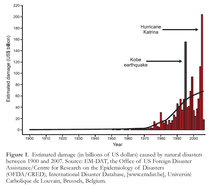
Display large image of Figure 1
4 To a far greater degree than the public at large, the earth science community is aware that earthquakes, tsunami, volcanic eruptions, landslides, floods, and fires are natural processes that have been occurring on Earth for billions of years. These processes are only hazardous when they threaten human beings. A ‘hazard’ thus can be defined as a natural process that threatens human life or property. A related concept, ‘risk’, may be expressed as the probability that a destructive event will occur multiplied by the event’s likely impact on people and property. Risk thus integrates hazard and social and economic vulnerability.
5 When we compare the effects of different natural hazards in North America, we find that those that cause the greatest loss of life are not the same as those that cause the most property damage. Severe weather events cause the largest number of deaths each year, although floods and landslides also take a toll. Loss of life from earthquakes in North America is surprisingly low, largely because of the high standards of building construction. But a single large earthquake can cause tremendous property damage. For example, the Northridge earthquake in Los Angeles in 1994 caused US$20 to 30 billion in property damage, but killed only 60 people. The next great earthquake in a densely populated part of California or in Seattle or Vancouver could cause US$100 to 200 billion in damage.
6 The purpose of this paper is to review the suite of natural hazards that most affect Canadians. We take a broad view of natural hazards by including not only classic geologic hazards−earthquakes, tsunami, volcanic eruptions, and landslides−but also briefly look at hydro-meteorological hazards, including severe weather phenomena (floods, hurricanes, tornadoes, blizzards, snow avalanches, hailstorms, ice storms, drought, and heat waves). Radon hazard, primarily related to the abundance of uranium in bedrock and overburden, is not discussed, but the interested reader is referred to an earlier paper in this series (Rasmussen and Gardner 2008) and references therein. For lack of space, we do not discuss climate change as a hazard per se, but we do comment on the significance of climate change in terms of other hazards. We discuss the character and distribution of each hazard, provide examples of past disasters, and attempt to extract broader implications from past events.
EARTHQUAKES
7 Earthquakes are one of the greatest natural hazards that humans face. During the 20th century alone, over two million people died during earthquakes and attendant fires, tsunamis, and landslides (Keller et al. 2008). Recently, in January 2010, an earthquake in Haiti killed about 23 000 people and, earlier, in December 2004, more than 225 000 people in eleven countries lost their lives to the tsunami triggered by the magnitude (M) 9.3 earthquake off the west coast of Sumatra in Indonesia. In December 2003, the ancient city of Bam in Iran was levelled by an M 6.1 earthquake, with the loss of almost 30 000 lives. The worst disaster in modern times occurred in China in July 1976, when the entire city of Tangshan was destroyed and over 240 000 people were killed in less than six minutes. Earlier, in 1556, an earthquake in north-central China near Shaanxi killed an estimated 800 000 people, one of the worst natural disasters in recorded history (Keller et al. 2008; United States Geological Survey 2009a). Fortunately, catastrophes of this scale do not occur in Canada, not because large earthquakes do not occur in this country, but rather because buildings and other infrastructure are less vulnerable to life-threatening collapse and fewer people are exposed to natural hazards.
Locations and Types of Earthquakes in Canada
8 Earthquakes are not randomly distributed. Most occur in well defined zones along the boundaries of Earth’s tec-tonic plates. In Canada, earthquakes are most common in coastal British Columbia near the western edge of the North America plate (Rogers and Horner 1991), but they also occur in many other parts of the country, notably southwest and eastern Yukon Territory, southern Ontario and Québec, and some of the Arctic Islands (Fig. 2).
Figure 2. Epicentres of earthquakes in Canada, 1627–2007 (M > 2.5). Source: Geological Survey of Canada.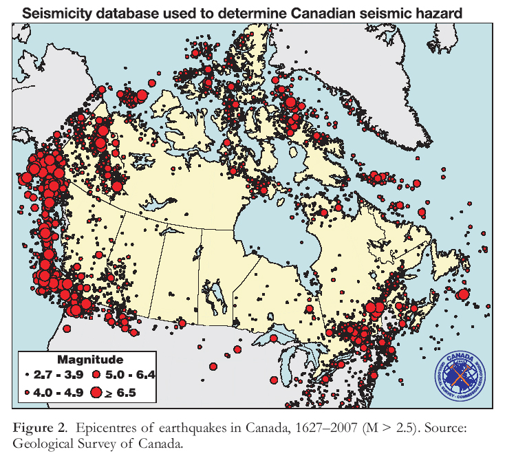
Display large image of Figure 2
9 Plate-boundary earthquakes occur along convergent, divergent, and transform plate boundaries. In Canada, plate-boundary earthquakes are restricted to the Pacific coast and are of two types. Subduction earthquakes occur along the thrust fault separating the North America and Juan de Fuca plates (Rogers 1988; Hyndman 1995; Hyndman et al. 1996). Subduction earthquakes occur when the strain energy that has accumulated in rocks adjacent to the convergent plate-boundary fault is suddenly released (Dragert et al. 1994; Hyndman and Wang 1995). The last great subduction earthquake on the Pacific coast, in January 1700, left geological traces in tidal marshes in northern California, Oregon, Washington, and British Columbia (Atwater et al. 1995, 2005; Atwater and Hemphill-Haley 1997; Clague 1996, 1997, 2002; Clague and Bobrowsky 1994a, b, 1999; Nelson et al. 1995, 2006). Its inferred extent, together with written records of the damage caused by its tsunami in Japan (Satake et al. 1996; Atwater et al. 2005), indicate that the quake likely had a magnitude larger than M 9.0.
10 The second type of plate-boundary earthquake on the west coast involves strike-slip or oblique-slip displacements along the Queen Charlotte Fault, which separates the Pacific and North America plates and extends from the north end of Vancouver Island to the southeast Alaska archipelago. The Queen Charlotte Fault is contiguous to the north with the Fair-weather Fault, and the latter extends along the coast of southeast Alaska to a block of complexly deforming crust (Yakutat Block) located east of the Aleutian Trench. Canada’s largest recorded earthquake, an M 8.1 event, ruptured a portion of the Queen Charlotte Fault in 1949 (Milne et al. 1978).
11 Intraplate earthquakes occur on faults within, rather than between, plates. Although commonly smaller than subduction earthquakes, some intraplate earthquakes have moment magnitudes in the M 7.5−8.0 range, e.g. the May 2008 quake in southwest China. Moderate and large intraplate earthquakes in densely populated areas are extremely destructive; they can claim tens of thousands of lives and may cause damage assessed in the tens or hundreds of billions of dollars. Because large (M >7) intraplate quakes are infrequent, most people are generally poorly prepared for them and older buildings may not be able to withstand the associated strong shaking. Canada’s largest intraplate earthquake is the M 7.3 Vancouver Island quake in 1946, which was felt as far away as Seattle, Washington, and Calgary, Alberta (Rogers and Hasegawa 1978). Fortunately, the epicentral area in 1946 was sparsely populated, hence damage was minor compared to what a similarly sized earthquake in the same area would cause today. A shallow, M 7 crustal earthquake close to Vancouver or Victoria would now cause catastrophic damage (Munich Reinsurance Company of Canada 1992).
12 Moderate-size intraplate earthquakes occur frequently in southern Ontario and Québec (Adams and Basham 1989, 2001). Most of these quakes are associated with the ancient rifted edge of the North American continent, which lies along the St. Lawrence River valley from Montreal to Sept Sles, Québec; related rift structures also occur along the Ottawa and Saguenay river valleys. Strain accumulates on these structures due to the westward movement of the North American Plate away from its eastern margin at the Mid-Atlantic Ridge. Earthquakes along the rift involve thrust movements at depths of 5 to 30 km and occur in three clusters (Fig. 2): western Québec, which experienced moderate earthquakes in 1732 (M 5.8), 1935 (M 6.2), and 1944 (M 5.8); Charlevoix, northeast of Québec City (1663, 1791, 1860, 1870 and 1925; M 6.0−7.0); and the lower St. Lawrence region near Baie-Comeau, Québec, comprising a diffuse cluster of mostly small earthquakes (Lamontagne 2002). The most recent and widely felt earthquake in central Canada in recent time occurred in the Saguenay region of Québec in 1988 (M 5.9).
Damaging Effects
13 Historical large earthquakes in Canada have caused little damage by California standards. The M 8.1 Queen Charlotte Islands earthquake in 1949 was larger than the 1906 San Francisco earthquake, yet caused little damage and no loss of life because no more than a few thousand people lived in the area of strong ground shaking at the time of the quake. Similarly, the epicentre of the 1946 Vancouver Island earthquake (M 7.3) was far enough from towns and other infrastructure that the damage was limited. Today, the same area supports a much larger population and far more economic wealth than in 1946, so if the same event were to occur now, financial damage would likely be in the hundreds of millions of dollars, if not more.
14 The intensity of seismic shaking is commonly expressed as the ratio of ground acceleration to the acceleration of gravity (Bolt 2003). Strong ground shaking can be especially damaging to a building if the horizontal component of motion is strong or if the frequency of the shaking matches the natural vibration frequency of the building, a phenomenon called ‘resonance’. In general, high-frequency, short-period seismic waves are most damaging to low structures, whereas low-frequency, long-period waves tend to damage tall buildings or long structures such as bridges.
15 The characteristics of local earth materials strongly influence the frequency distribution of wave forms and ground-motion attenuation during an earthquake (Bolt 2003). The dense granitic and metamorphic rocks of the Canadian Shield can transmit earthquake energy very efficiently, and even moderate earthquakes can therefore cause damage over large areas. In contrast, seismic energy and associated ground shaking attenuates rapidly away from the epicentres of most earthquakes in the extremely heterogeneous, folded, and faulted crust of western North America. Seismic waves also move much more slowly through loose sediments than through bedrock, especially if the sediments have high water content. For example, seismic waves typically slow down as they move from bedrock to alluvial sands and gravels. As P (primary) and S (secondary or shear) waves decelerate, some of their forward-directed energy is transferred to surface waves. This effect, known as seismic amplification, increases the amount of ground motion experienced in an earthquake.
16 Intense seismic shaking can elevate intergranular pore-water pressure in loose, water-saturated sediments and cause them to liquefy. Liquefaction commonly takes place at shallow depths and is most common in loose sandy and silty sediments (Jefferies and Been 2006). Liquefaction may be accompanied by lateral shifts of more cohesive earth materials on one or more layers of fluidized sediment, causing much damage to roads and buildings at the surface and to gas, water, and sewer lines buried at shallow depth. Watery sand and silt may also flow, under pressure, upward along fissures in overlying solid materials and onto the surface to form ‘sand blows’ or ‘sand volcanoes’. Liquefaction causes the land surface to settle irregularly, which, in turn, may damage foundations of buildings, water and sewer lines, and other structures.
17 Some earthquakes raise or lower the land over large areas. The Cascadia subduction earthquake in 1700 caused parts of the Pacific coasts of Vancouver Island, Washington, and Oregon to subside up to 2 m, inundating coastal marshes and forests with sea water (Peterson et al. 1997). A large crustal earthquake near Seattle about 1000 years ago produced co-seismic uplift of up to 7 m (Bucknam et al. 1992).
18 Large earthquakes may also trigger hundreds or thousands of landslides. The 1970 Ancash earthquake in Peru (M 7.9) triggered a huge landslide that destroyed the towns of Yungay and Ranrahirca, killing thousands of people (Plafker and Ericksen 1978). A large (M 7+) earthquake in southern Québec in 1663 triggered ‘quick clay’ failures in glacial marine sediments in the St. Lawrence River valley (Filion et al. 1991), and the 1946 Vancouver Island earthquake triggered hundreds of mainly small landslides in the mountains of central Vancouver Island (Mathews 1979).
19 Ground shaking and surface rupture can sever power, telecommunication, and gas lines, starting fires. Such fires may be difficult to suppress because fire-fighting equipment may be damaged; streets, roads, and bridges blocked; and water mains broken. Appliances such as gas water heaters may topple when shaken, producing gas leaks that can ignite. The San Francisco earthquake of 1906 has often been referred to as the ‘San Francisco Fire,’ because most of the damage and loss of life were caused by a firestorm that ravaged the city for several days following the quake. Such a firestorm is unlikely to happen in a Canadian city today, but localized fires can be expected in the event of a large (M 7+) event close to an urban centre.
TSUNAMI
Historic Events
20 The west coast of Canada is located along the Pacific ‘Ring of Fire’ and is vulnerable to tsunami generated by subduction earthquakes that occur beneath the Pacific Ocean (Murty 1977; Clague et al. 2000, 2003). The largest tsunami results from great earthquakes that rupture the Cascadia plate boundary where the oceanic Juan de Fuca Plate moves beneath North America (Fig. 3). The British Columbia coast is also affected by tsunami of more distant Pacific earthquakes. In fact, the largest tsunami to strike British Columbia in historical time was generated by the M 9.2 Alaska earthquake in March 1964 (Plafker 1969; Lander 1996). A series of waves radiated outward from the epicentre of the earthquake off south-central Alaska and, within a few hours, reached the outer coast of British Columbia. The tsunami caused about $10 million damage (1964 dollars), mainly to the Vancouver Island communities of Port Alberni, Hot Springs Cove, and Zeballos (Wigen and White 1964; Murty and Boilard 1970; Murty 1977; Thomson 1981). Damage was greatest at Port Alberni, located at the head of Alberni Inlet, where 260 homes in the town were damaged, 60 of them extensively (Thomson 1981).
21 Tsunami of more local extent, triggered by landslides and shallow crustal earthquakes, also pose a hazard to Canada’s west coast, especially in steep-walled fiords and inlets that indent the coast (Clague 2001). A submarine landslide in April 1975 at the head of an inlet on the northern British Columbia coast produced waves up to 9 m high that damaged wharfs and other shoreline infrastructure at Kitimat (Murty 1979; Prior et al. 1982, 1984; Johns et al. 1986; Skvortsov and Bornhold 2007). More than 10 million m3 of fiord-wall and deltaic sediments failed and flowed into the inlet, mobilizing an additional 25 million m3 of fiord-bottom sediments. The subaqueous debris flow travelled over 5 km from the delta front on slopes inclined less than 0.4° to a water depth of 210 m (Prior et al. 1984). Similar unstable sediments are present in most fiords on the British Columbia coast; local, landslide-triggered tsunamis are therefore also possible in many areas other than Kitimat Inlet.
Figure 3. Schematic diagram showing generation of a tsunami by displacement along the fault separating the North America and Juan de Fuca plates during a great earthquake at the Cascadia subduction zone (Clague et al. 2006, p. 130). The largest and most energetic waves travel east and west from the seafloor rupture. Smaller waves move away from the fault in other directions.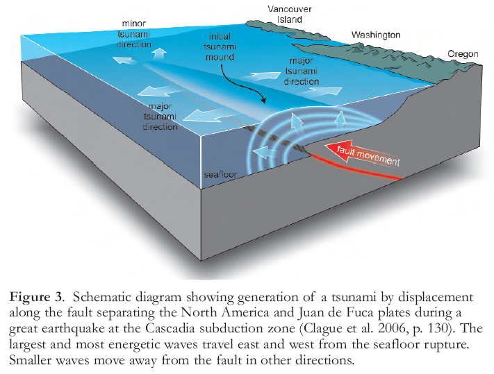
Display large image of Figure 3
22 Tsunami can also be triggered by rockfalls and rockslides from the walls of British Columbia fiords. Born-hold et al. (2007) proposed that the First Nations village of Kwalate in Knight Inlet was destroyed by a local tsunami triggered by the catastrophic failure of a nearby steep rock wall about 500 years ago.
23 Fortunately, most of British Columbia’s coastal residents live along the Strait of Georgia, an area of low tsunami risk (Fig. 4). The total population in communities at higher risk, on western Vancouver Island (e.g. Tofino, Ucluelet, Port Alberni) and at fiord heads (e.g. Kitimat, Bella Coola), is less than 10 000, and small in comparison to the population of tsunami-prone areas on the Pacific coasts of Oregon and Washington.
24 A large submarine landslide can also generate a tsunami, as happened at the edge of the Canadian Atlantic continental shelf on November 18, 1929. On that day, an M 7.2 earthquake occurred about 20 km beneath the seafloor at the southern edge of the Grand Banks, some 250 km south of Newfoundland (Heezen and Ewing 1952; Piper et al. 1988). Earthquake shaking triggered a huge submarine slump, which, in turn, set off a tsunami that propagated across the Atlantic Ocean (Fine et al. 2005). The tsunami damaged more than 40 coastal communities on Burin Peninsula and claimed 27 lives in Newfoundland and one in Nova Scotia (Whelan 1994). The tsunami arrived near the peak of a high tide, thus increasing the damage.
25 Landslides may also generate destructive displacement waves and seiches in lakes and rivers bordered by steep, unstable slopes and in lakes containing actively growing deltas. Such events can cause much damage and loss of life. For example, in 1880, a large mass of late Pleistocene glacial marine sediments slid into the Fraser River at Haney, east of Vancouver, producing a displacement wave that travelled several tens of kilometres up and down the river, causing considerable damage to boats, wharves, and buildings at the shore (Evans 2001). And in August 1905, a landslide in Pleistocene glacial lacustrine sediments crossed the Thompson River near Spences Bridge in southwestern British Columbia, producing a 5-m-high displacement wave that rushed more than 1.5 km upstream, destroying twenty buildings and drowning 15 people (Evans 2001). Three years later, in 1908, a landslide on the Liève River in western Québec generated a displacement wave that inundated part of the village of Notre-Dame-de-la Salette, killing 27 people (Evans 2001).
Figure 4. Tsunami hazard zones in coastal areas of southwestern British Columbia (Clague et al. 2006, p. 138). Western Vancouver Island is at risk from large tsunami triggered by great subduction earthquakes beneath the Pacific Ocean. The tsunami risk in the Strait of Georgia is much lower and is related to crustal earthquakes and subaqueous landslides. Local, landslide-triggered tsunami pose a hazard to some coastal communities, especially those at the heads of fiords.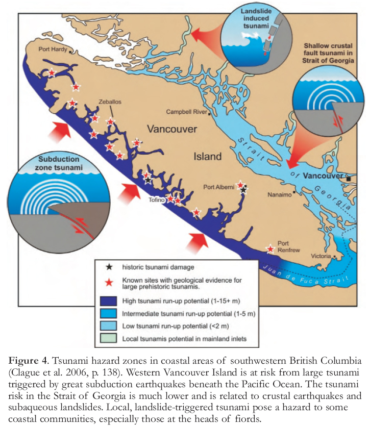
Display large image of Figure 4
26 Tsunami height and run-up depend on the distance from the source, possible resonance amplification in inlets and bays, tidal height at the time of the tsunami, shoreline configuration, and the gradient of the seafloor directly off the coast. Numerical modelling by Chasse et al. (1993) has shown that the maximum amplitude of a tsunami in the St. Lawrence Estuary would be about 1.5 m. Such a tsunami, however, could reach up to 4.5 m above sea level (asl) at the highest tide, or only 0.9 m asl at the lowest tide. Also, the tsunami would travel much faster along the north side of the estuary, due to the greater water depth, than along the south side. Similar dependence of speed on propagation direction was noted during the 1929 Grand Banks tsunami − it took much longer for the tsunami to reach Nova Scotia than Newfoundland, even though Nova Scotia was closer to the tsunami source (Berninghausen 1968).
Prehistoric Events
27 Sand sheets deposited by prehistoric tsunami have been found in mud and peat deposits in protected tidal marshes at many sites on western Vancouver Island, Washington, and Oregon (Clague and Bobrowsky 1994a, b, 1999; Clague 1997, 2002; Peters et al. 2007). The sand sheets become thinner and finer in a landward direction, and commonly contain marine microfossils, indicating that they were deposited by strong landward surges of water. Some of the sand sheets directly overlie buried peaty or forest soils that subsided during great earthquakes at the Cascadia subduction zone (Atwater et al. 1995; Clague and Bobrowsky 1994a, b, 1999; Clague 1997, 2002). Analogues for these prehistoric subduction earthquakes include the great earthquakes in Chile in 1960, Alaska in 1964, and Indonesia in 2004, each of which produced widespread crustal subsidence in their source areas and destructive fartravelled tsunami.
28 Tsunami deposits also have been found in nearshore coastal lakes in Oregon and on western Vancouver Island (Hutchinson et al. 1997, 2000; Clague et al. 1999; Kelsey et al. 2005). Tsunamis enter the lakes by surging up outlet streams or by crossing sand dunes that lie between some of the lakes and the sea. The most complete record found to date is from Bradley Lake in Oregon, where there are 14 tsunami layers in a sequence spanning the last 7500 years (Fig. 5; Kelsey et al. 2005).
29 So far, evidence for a prehistoric tsunami has been found only on Canada’s west coast, but similar evidence likely exists in Atlantic Canada. A widespread layer of 8000-year-old sand, which has been found in coastal areas of eastern Scotland, western Norway, and Iceland, was deposited by a large tsunami triggered by a submarine landslide in the North Atlantic Ocean (Dawson et al. 1988; Bondevik et al. 1997). On the basis of the known extent and character of the landslide deposit, the tsunami may have been large enough to impact and leave a trace along the Atlantic coast of Canada.
VOLCANIC ERUPTIONS
30 Approximately 500 million people live close to volcanoes, and as the human population continues to grow, this number will increase. In the past 100 years, nearly 100 000 people worldwide have been killed by volcanic eruptions; approximately 28 500 lives were lost in the 1980s alone (Wright and Pierson 1992; International Association of Volcanology and Chemistry of the Earth’s Interior, Subcommittee on Decade Volcanoes 1994). Several active or potentially active volcanoes in western North America lie near cities with populations of over 500 000 people. More than 90 percent of Canada is risk-free from local volcanic activity, but a huge ‘supervolcano’ eruption in the Yellowstone volcanic field in Wyoming–Montana, the Long Valley caldera in California, or the Aleutian Arc in Alaska would likely have an impact throughout North America in the form of ash fall and ash clouds in the atmosphere. Supervolcano eruptions expel more than 1000 km3 of ejecta, in contrast to the 4 km3 of ejecta erupted at Mount St. Helens in May 1980 and the 30–35 km3 erupted from Mount Katmai in 1912 (Wood and Kienle 1990; United States Geological Survey 2005, 2009b). Even a small explosive eruption, however, could disrupt air travel in Canada.
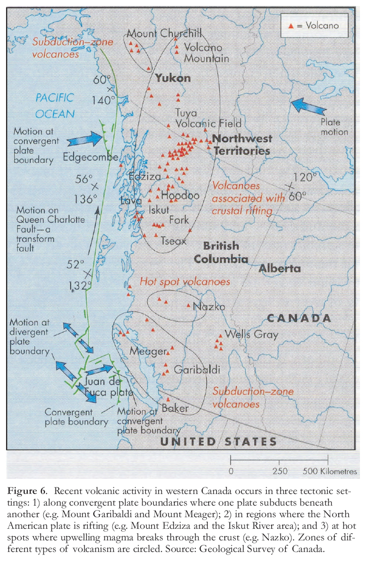
31 Young volcanoes in Canada are restricted to British Columbia and southern Yukon Territory (Souther 1970, 1977; Hickson and Edwards 2001; Fig. 6). Several eroded stratovol-canoes in southwestern British Columbia form the northern part of the Cascade volcanic chain, which owes its origin to subduction of the oceanic Juan de Fuca Plate beneath North America. They include Mount Garibaldi, Mount Cayley, and Mount Meager, but only Mount Meager has had an eruption in the Holocene. Similar volcanoes are also present in the boundary area between Alaska and the Yukon, north of the Aleutian Trench.
32 A large number of Pleistocene and postglacial volcanoes occur within a broad, north-trending belt in northwestern British Columbia and southernmost Yukon (Fig. 6; Souther 1970, 1977; Hickson and Edwards 2001). Most of these volcanoes are small and the product of one or a few effusive eruptions of basaltic magma, but Mount Edziza and Hoodoo Mountain have been formed by numerous eruptions over a long period of time, and some of the eruptions were explosive. Scientists believe that volcanism in northwestern British Columbia is the result of crustal rifting caused by right-lateral displacements on the Queen Charlotte and Fairweather faults to the west (Hickson and Edwards 2001). A third group of volcanoes extends in a westerly direction from Nazko in central British Columbia to the Pacific coast near Bella Coola. Volcanoes in this last group increase in age west-ward−Nazko volcano is only 8000 years old, whereas the dikes that fed former volcanoes on the British Columbia coast are Miocene. The simplest interpretation of this pattern is that the volcanoes formed on the westward-moving North America plate over a hot spot in the mantle (Fig. 6; Rogers and Souther 1983). A group of small, mainly basaltic volcanoes, some of which are Holocene in age, occur in eastern British Columbia in Wells Gray Provincial Park. Many of the volcanoes have unusual morphologies as a result of their formation beneath the ice sheets that episodically covered the area.
Figure 5. Stratigraphy of Holocene sediments in Bradley Lake, Oregon, showing 14 sand layers interpreted to have been deposited by tsunamis triggered by great earthquakes in the eastern North Pacific Ocean (Kelsey et al. 2005, Fig. 4).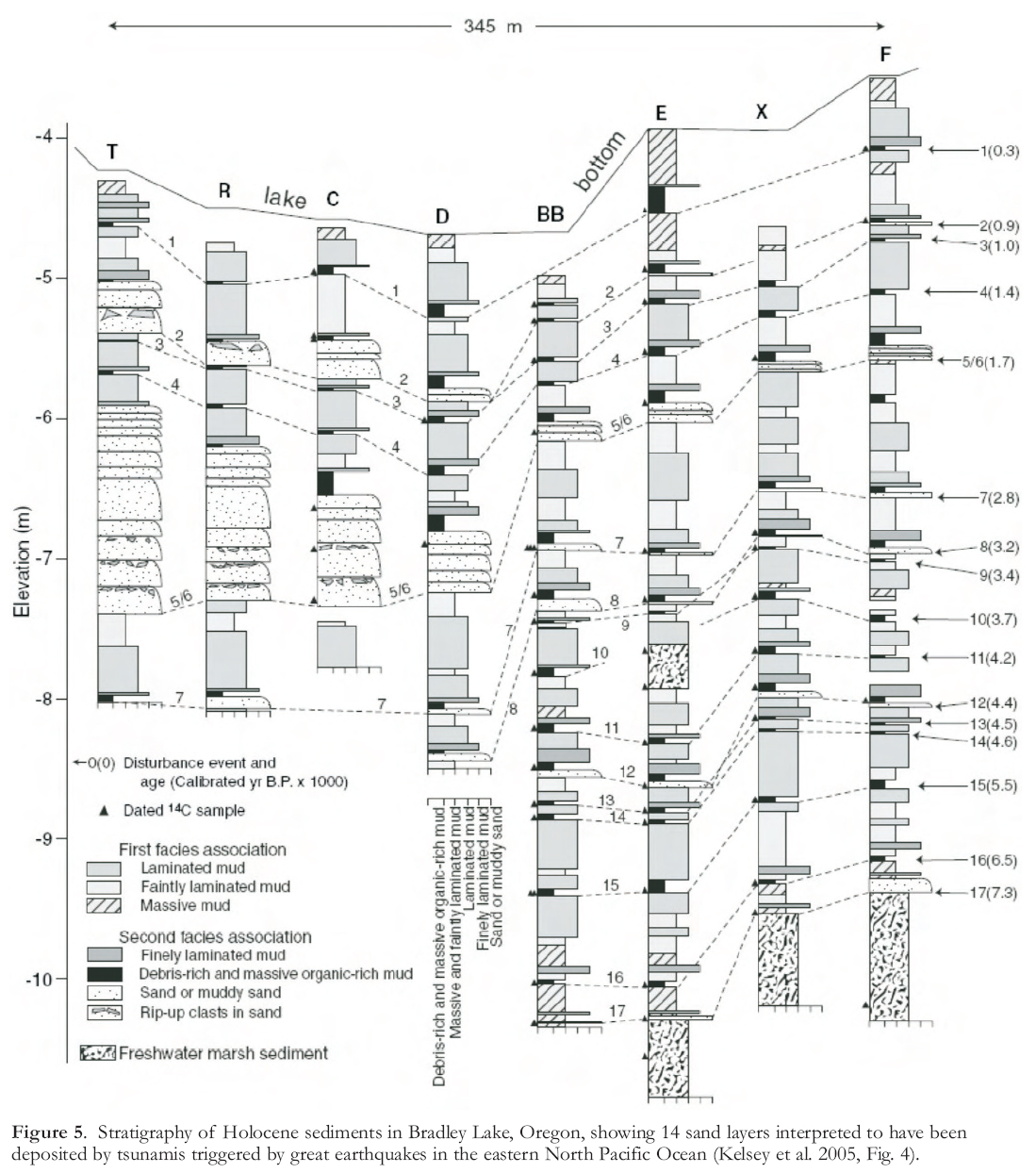
Display large image of Figure 5
Display large image of Figure 6
33 The volcano that poses the greatest risk to Canada is actually located in the United States. Glacier-cloaked Mount Baker, in northern Washington State, is a stratovolcano formed by numerous eruptions over the past 50 000 years. The conical shape of Mount Baker reflects its status as an active volcano (Fig. 7). It most recently erupted in 1843, and venting of gases and hot fluids from the summit crater in the late 1970s provided a timely reminder that the volcano remains ‘armed and dangerous’.
34 The volcanic hazards of greatest concern at Mount Baker are ash falls, landslides, volcanic mudflows (lahars), and infilling of river valleys with sediment. A major eruption of Mount Baker could spread ash over Vancouver, Abbotsford, Chilliwack, and other cities and towns in southern British Columbia. The ash would at least temporarily paralyze air and ground traffic and could impact water quality.
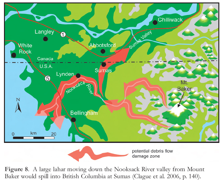
35 The rocks around Mount Baker’s summit crater have been extensively altered to soft clay minerals by circulating hot acidic groundwater. These altered rocks would likely fail if the volcano became inflated with magma at the onset of an eruption, but a large landslide could occur on the steep flanks of the volcano even without an accompanying eruption, given the steepness of the slopes and the weakness of the rocks. Such landslides could range in size from small debris avalanches and debris flows to massive collapses of the entire summit or sides of the volcano. During an eruption of Mount Baker, hot volcanic debris would mix with water melted from snow and ice on the summit and flanks of the mountain to form large lahars that would surge down adjacent river valleys. A lahar or series of lahars, moving down the Nooksack River on the north side of Mount Baker, could carry sufficient debris and water to spill into British Columbia at Sumas (Fig. 8).
LANDSLIDES
36 Thousands of landslides occur annually in Canada. Fortunately, most of them are either small or occur in remote areas distant from towns and other infrastructure. Nonetheless, landslides have claimed, on average, about four lives each year in Canada over the past 150 years (Evans 1999). Nearly half of the historic loss of life is attributable to two disasters, one in April 1903 at Frank, Alberta, and the second near Britannia, British Columbia, in March 1915. The Frank slide destroyed much of the community of Frank and killed about 75 of its residents (Fig. 9; McConnell and Brock 1904; Cruden and Krahn 1973). It resulted from the sudden failure of a large (ca. 30 million m3) mass of Paleozoic limestone on Turtle Mountain. Although the primary cause of the failure was geological, i.e. weak planes in the folded and faulted sedimentary rocks, the trigger may have been underground coal mining at the base of the mountain. Turtle Mountain was also predisposed to failure because the toe of the slope had been eroded by Pleistocene glaciers (Jackson 2002). The 1915 Britannia slide (ca. 100 000 m3) was much smaller than the landslide at Frank, but it claimed nearly as many lives (Clague and Turner 2003). An estimated 56 people were killed when a sudden avalanche of rock overwhelmed a makeshift mining camp located about 8 km east of the town of Britannia. As in the case of the Frank slide, mining probably contributed to the failure.
Figure 7. Mount Baker, an active stratovolcano, looms above the Vancouver skyline. It last erupted in 1843. A major eruption today would melt the glaciers on Mount Baker, causing floods and lahars in the valleys that extend off the flanks of the volcano. Photo by J. Clague.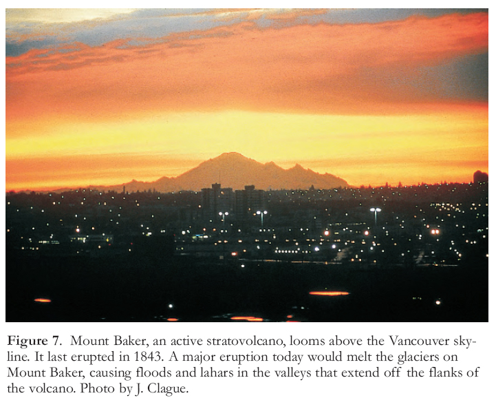
Display large image of Figure 7
Display large image of Figure 8
37 Although the total loss of life in Canada from landslides is relatively low, damage to infrastructure and secondary losses probably exceeds $200 million annually (Geological Survey of Canada, unpublished data, 2010). Much of the loss results from closure and clearing of highways and rail lines. An extreme example is the huge (48 million m3) Hope slide, which buried Highway 3 in southern British Columbia to a depth of 80 m on January 9, 1965 (Mathews and McTaggart 1978); the highway was closed for weeks.
Distribution
38 Landslides occur in all provinces and territories in Canada, as well as on the seafloor off the Pacific, Atlantic, and Arctic coasts, but their incidence is highest in the mountainous parts of the country – the Cordillera of British Columbia, Yukon, and Alberta, and the Appalachian provinces of Québec and New Brunswick (Mollard 1977; Evans 2001). Areas at risk from landslides in other parts of the country are localized, notably in parts of the St. Lawrence Valley underlain by Leda Clay, and along glacial meltwater valleys eroded into shales and clays on the Prairies. Leda Clay was deposited in an arm of the sea that occupied the St. Lawrence Valley at the end of the last glaciation. Its constituent clay minerals are weakly bound to one another; an apt metaphor for the sediment is a ‘house of cards’. When disturbed, grains may collapse and become suspended by water in the pores of the sediment, leading to liquefaction and landslides.
39 Some of the most damaging landslides in Canada are debris flows – watery slurries of silt, sand, gravel, and woody debris. They range in volume from several hundred cubic metres to about 100 000 m3, and therefore are small in comparison to many other types of landslides. Most debris flows are funnelled along steep stream channels and ravines and are triggered by intense rainstorms or rain-on-snow events (VanDine 1985; Jakob and Weatherly 2003). They are common in the mountains of western British Columbia, but are by no means restricted to that area.
Figure 9. The 1903 Frank slide is Canada’s best-known landslide and a classic example of a rock avalanche. It travelled more than 3 km in 100 seconds and buried part of the mining town of Frank, Alberta, killing about 75 people. Coal mining at the base of the mountain likely triggered the landslide. Geological Survey of Canada photo.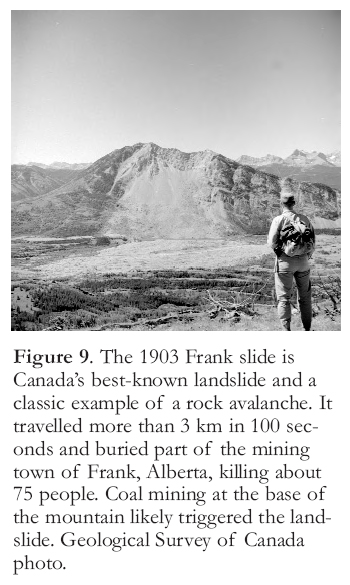
Display large image of Figure 9
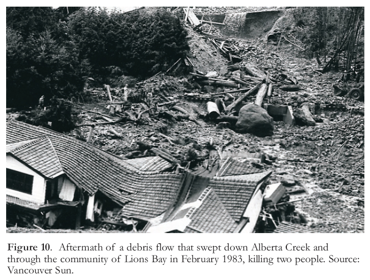
Display large image of Figure 10
40 Events following establishment of the community of Lions Bay, located along Howe Sound between Vancouver and Squamish, illustrate the problems that debris flows can cause. Development at Lions Bay began in 1957 during construction of Highway 99. Most of the community is located on a late Pleistocene fan and on adjacent rock slopes, but about 63 houses are situated on the coalesced Holocene fans of Harvey and Alberta creeks. On February 11, 1983, a disastrous debris flow swept down Alberta Creek into Lions Bay (Fig. 10; Thurber Consultants Limited 1983; Jackson et al. 1985). All of the bridges and culverts along Alberta Creek, with the exception of the British Columbia Railway bridge, were destroyed. About 10 000 m3 of debris were deposited below the highway; in addition, some sediment flowed into Howe Sound. Within the community of Lions Bay, destructive tongues of logs and boulders were forced out of the channel at corners and obstructions, one of which killed two people in a trailer.
41 Measures taken to protect people and property in Lions Bay and elsewhere along Howe Sound from future debris flows include the construction of debris catch basins and new highway bridges, lining of stream channels, and channel clearing. The catch basins trap debris before it reaches the highway, rail line, and homes. The other protective works allow debris flows to travel unimpeded along channels through communities. The total cost of these works has been estimated at $12–17 million (1985 dollars; Jackson et al. 1985).
SNOW AVALANCHES
42 A snow avalanche is a slide or flow of snow down a mountainside. The snow mass may travel as a coherent block, deforming and fragmenting along its path, or it may rapidly disaggregate into small flakes or grains that move independently of one another. Snow avalanches range in size from those too small to bury a person to more than one million m3, capable of destroying large buildings or many hectares of forest.
Process
43 Slab avalanches, which are the most dangerous type, require a buried weak layer and an overlying stronger mass of snow. Weather determines the evolution of the snowpack and the formation of weak, unstable layers within the snow. The most important contributing factors are heating by solar radiation, radiative cooling, temperature gradients in the snowpack, snowfall amounts and type, and wind (McClung and Schaerer 1993; Jamieson 2001). Weak layers in the snowpack can form in three main ways (Jamieson 2006). First, wind can contribute to the rapid build-up of snow (wind slabs) on sheltered lee slopes. If winds become stronger during a snowstorm, a dense layer of broken and packed snow crystals (hoar) may accumulate on a delicate layer of unbroken crystals that had fallen earlier in the storm. In this manner, the layer of unbroken crystals becomes a buried weak surface along which failure may subsequently occur. Second, surface hoar, also called hoar frost, may form on cold clear nights by sublimation. Ice crystals produced in this manner form a weak layer that changes only slowly once buried. In contrast, the overlying and underlying snow layers commonly gain strength over a period of days to weeks, leaving the buried surface hoar as a potential failure plane. Third, weak layers of hoar can develop inside the snowpack.
44 During the first few seconds of a slab avalanche, the failed snow mass comprises large fractured blocks of snow sliding downslope. The slab rapidly gathers speed and, commonly within a few tens of metres, disinte-grates into smaller fragments and, in many cases, individual grains of snow. At velocities above about 35 km/hr, dry avalanches commonly generate a cloud of powdered snow that billows above the main mass of flowing snow. Wet avalanches have higher densities than dry ones (300–400 kg/m3 vs. 50–150 kg/m3), but do not attain the extreme velocities of some large dry avalanches (Jamieson 2001). Large snow avalanches may have sufficient momentum to climb tens of metres or more up opposing slopes and destroy the forest cover. They may also displace air, producing a damaging air blast that arrives seconds before the avalanche.
Figure 11. Distribution of avalanche fatalities in Canada according to the activity of the victims at the time of the accident (Jamieson, 2001, p. 82). Categories include recreation (skiing, snowboarding, and snowmobiling); transportation, including highway and railway construction; resource industry, including accidents at work camps; and residential and commercial buildings. Some accidents have been excluded because they do not fit any of these categories. In the past 50 years, the number of recreational accidents has increased dramatically, whereas the number of other accidents has decreased.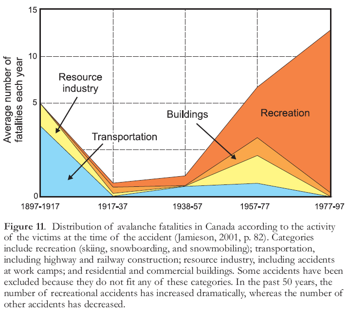
Display large image of Figure 11
45 Most large snow avalanches are released from slopes with gradients of 30−45°, although some occur on slopes as steep as 60° (Abromelt et al. 2004). Slopes in the 30–45° range are also popular with skiers, snowboarders, and snowmobilers, which is why recreationists often trigger avalanches. Fewer than 5% of dry snow avalanches begin on slopes of less than 30°, but wet snow slides can occur on slopes under 25° (Abromelt et al. 2004). Higher elevations commonly have a higher avalanche hazard than lower ones because they receive more snow, have fewer trees to impede avalanches, and commonly are windier. Gullies or ravines funnel snow avalanches, increasing their destructive force and making escape difficult.
Snow Avalanches in Canada
46 Over 600 people have died in snow avalanches in Canada since the earliest reported accidents in the middle nineteenth century (Stethem et al. 2003; Abromelt et al. 2004). Until the early twentieth century, most avalanche fatalities were people engaged in construction of railways and roads, or working at mine sites (Fig. 11). The Canadian Pacific Railway line, completed in 1886, was the first rail line built across Canada. During construction of the rail line and in the early years of its operation, ‘white death’ snow avalanches claimed approximately 250 lives in Rogers Pass in Glacier National Park, British Columbia (Woods 1983). The number of industrial and transportation fatalities from snow avalanches, however, is now low, mostly because pre-emptive measures to reduce the risk are routinely taken to protect road and rail lines. In contrast, the number of recreational accidents has increased dramatically since the 1930s. Indeed, an average of 12 people have died, annually, in snow avalanches in Canada over the past decade, and nearly all of them were recreationists who were buried in an avalanche that either they or a member of their group triggered.
47 Snow avalanches also cause traffic delays, with significant economic losses (Morrall and Abdelwahab, 1992). For example, closures of the Trans-Canada Highway associated with snow avalanches in Rogers Pass, BC, average about 100 hours per winter. A typical two-hour closure of this highway can result in monetary losses of between $50 000 and $90 000, depending on the number of trucks that are delayed (Morrall and Abdelwahab 1992); the average annual cost of snow avalanches at Rogers Pass alone due solely to traffic delays is therefore several million dollars. This sum does not include the costs of preventing avalanches and clearing the highway during closures. Taking into account the many other highways in British Columbia that are affected by snow avalanches, the total annual cost of traffic delays in that province alone likely exceeds $5 million. This figure is conservative because it does not include railway delays or the effect of closures on timely deliveries, lost business, and other indirect costs.
48 Property damage caused by snow avalanches in Canada in most years is less than $500 000, although much damage is likely unreported. In comparison, damage from snow avalanches in the European Alps in some winters can be an order of magnitude larger than in Canada. Typical infrastructure damaged in Europe includes residential and commercial buildings in ski resorts, ski lifts, vehicles, and communication and power lines. Snow avalanches also damage forests by uprooting, breaking, and injuring trees.
49 Most snow avalanches in Canada occur in remote or uninhabited areas during fall, winter, and spring, and therefore go unnoticed. They are extraordinarily common – by one estimate, about 1.5 million snow avalanches large enough to bury a person occur annually in western Canada (Jamieson 2001). Yet, only about 100 avalanche accidents are reported in this region each year. Most snow avalanches occur in the mountains of Alberta, British Columbia, Yukon, and Northwest Territories (Fig. 12). They are also common in parts of Labrador, in the Gaspé region of Québec, along the north shore of the St. Lawrence River, in parts of Newfoundland, and along the eastern margin of the Arctic Islands. Snow avalanches are uncommon, except in localized areas, in the Prairies and Arctic, and in central and eastern Canada.
RIVER FLOODS
50 Flooding can occur along any stream or river and, consequently, is the most universally experienced natural hazard. In Canada and the United States, floods have caused more damage than any other hazardous process in the twentieth century − some 10 000 people have been killed since 1900 and property damage has exceeded $4 billion per year over the past decade alone (Andrews 1993).
51 Most river flooding is related to the amount and distribution of precipitation in the drainage basin, the rate at which the precipitation infiltrates the ground, the presence or absence of a snowpack, air temperature, and how quickly runoff reaches the river. Antecedent soil moisture conditions are also important because water-saturated soil cannot hold additional moisture; flooding is more likely if heavy rains fall on a saturated drainage basin or on frozen ground.
52 Flooding can also result from the formation and subsequent breakup of ice jams on rivers, and from the sudden draining of lakes impounded behind moraines, glaciers, and landslide deposits (Fig. 13; Costa and Schuster 1988; Clague and Evans 1994, 2000). Glacier dams are notoriously unstable and can fail due to flotation of part of the dam or, alternatively, to drainage through tunnels at the base of the ice. For example, Summit Lake in northwestern British Columbia has drained rapidly via an ice tunnel at the base of Salmon Glacier nearly every year since 1961 (Fig. 14; Mathews 1965; Mathews and Clague 1993). A moraine dam may be rapidly incised by overtopping waves triggered by a landslide or ice avalanche into the lake. The sudden draining of water impounded in the lake can produce a flood with a peak discharge many times larger than the peak discharge of a ‘normal’ rainfall or snowmelt-triggered flood in the same basin. Such floods and associated debris flows can be deadly if people live along their paths. For example, a debris-laden flood caused by the failure of a moraine dam at Lago Placacocha in the Cordillera Blanca of Peru in 1941 killed about 5000 people in the city of Huaraz (Lliboutry et al. 1977).
Figure 12. Regional occurrence of snow avalanches in Canada. The map is generalized−among other things, it does not take into account isolated steep areas and isolated areas of heavy snowfall or strong winds. Modified from Jamieson (Fig. 12, 2001).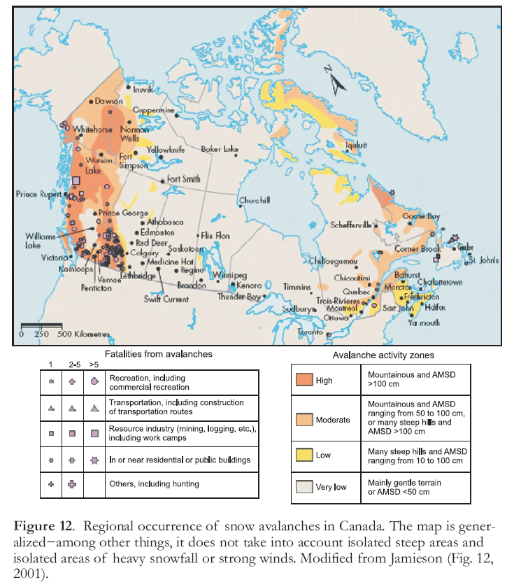
Display large image of Figure 12
Temporal and Geographic Distribution
53 Flooding occurs at different times of the year in Canada depending on the geographic location of the watershed and the size of the stream or river involved. Large Canadian rivers, e.g. the Fraser and the Red, always flood in late spring due to a combination of melt of heavy snowpacks, prolonged warm weather, and heavy rainfall. The basins of these rivers are too large to be influenced by thunderstorms or by a single cyclonic storm. Mid-sized rivers may also crest during the late spring, although those in temperate areas such as the Pacific coast commonly flood in the fall during periods of heavy rain after snow has accumulated on the ground. Small streams can flood at any time of the year − during spring when snow rapidly melts or rain falls on still-frozen ground; in mid-water thaws; or during summer rainstorms. These streams can reach flood stage very quickly. Ice-jam floods occur in most parts of Canada, but are especially common in the north. They happen when rivers ice-over in the fall or during ice break-up in late spring (Brooks et al. 2001). Ice cover along upstream reaches of a river may break up and then jam against downstream river ice. River water rises against the downstream obstruction and spills out of its channel, inundating the adjacent low-lying floodplains. Flooding may also occur when the ice jam breaks, releasing the impounded water behind the dam.
Figure 13. Oblique aerial view of the breached moraine at Nostetuko Lake in the southern Coast Mountains of British Columbia. In 1983, an ice avalanche from the retreating toe of Cumberland Glacier (arrow) plunged into Nostetuko Lake, generating waves that overtopped and breached the moraine dam. The sudden release of 6 million m3 of water produced a huge, though short-lived, flood in the valley below. Photo by Stephen Evans, Geological Survey of Canada.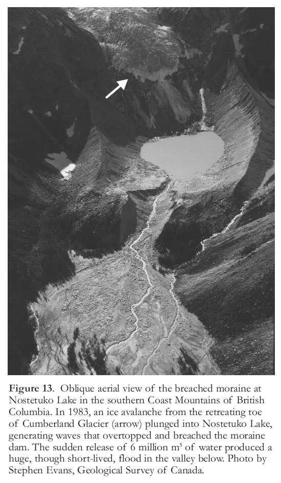
Display large image of Figure 13
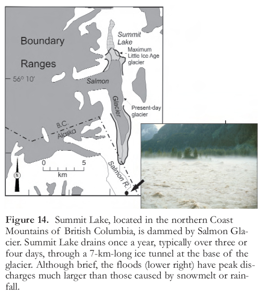
Display large image of Figure 14
54 One of the areas in Canada at greatest risk of flooding is southern Manitoba (Brooks et al. 2001, 2003). In the spring of 1997, rapid snowmelt and heavy rain on water-saturated and frozen soils produced widespread and prolonged flooding along the Red River Valley in North Dakota, Minnesota, and southern Manitoba. Over 7000 military personnel were mobilized for 36 days to assist in strengthening dikes and in relocating nearly 25 000 evacuees along the Red River Valley. The floodwaters inundated the broad valley floor to depths of 12 m and created a vast temporary lake some 40 km across and 1840 km2 in area (Fig. 15). Many communities were under water or cut off from surrounding areas; three people drowned; and damage totalled $815 million (Brooks et al. 2001). Winnipeg was spared because the Red River Floodway, constructed at considerable cost after an earlier flood, channelled peak flows around the city (Fig. 16). The floodway has been used in 27 of the 40 years since its completion. In contrast, in the spring of 1951, a flood similar to that of 1997 and resulting from similar conditions, lasted 51 days, forcing the evacuation of 60 000 people in Manitoba; nearly 10 percent of Winnipeg was inundated during this event. Since 1900, other damaging Red River floods occurred in 1904, 1916, 1922, 1923, 1960, 1966, 1969, 1970, 1974, 1979, 1984, 1986 (Andrews 1993; Brooks et al. 2003), and 2009. Given this history, the Red River Floodway is being expanded, with an expected completion date in 2010, further reducing the flood risk to the city.
55 Geology plays an important role in Red River flooding in two ways. First, the Laurentide Ice Sheet depressed the crust several hundred metres during the late Pleistocene. Because the centre of ice loading was located to the north, the magnitude of depression decreased progressively to the south into the United States. As a result, isostatic rebound has been, and continues to be, greater at the northern end of the Red River Valley than in the south; the gradient of the Red River is therefore decreasing, making it progressively more difficult for the river channel to contain flood waters (Brooks et al. 2001). Second, most of the Red River Valley is underlain by low-permeability clay deposited in glacial Lake Agassiz, a huge late Pleistocene lake impounded by the retreating Laurentide Ice Sheet.
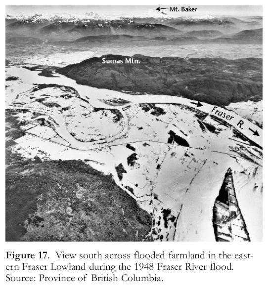
56 Another notable Canadian flood disaster was the Fraser River flood in early June 1948. A late, but wet spring and the rapid onset of warm temperatures triggered rapid melting of a heavy snowpack in late May (Sewell 1969). The river level rose and overtopped dikes in the Fraser Lowland beginning on 26 May (Fig. 17). Flood waters peaked on 10 June at Mission; by that time, the river had breached over a dozen dikes and flooded about 20 000 ha of land. Much of Agassiz and Rosedale, and parts of Mission were inundated (Andrews 1993). Vancouver was isolated from the rest of Canada, except by air (Sewell 1969). Ten people died, 200 families were left homeless, and 16 000 people were evacuated. Three thousand buildings were destroyed and 82 bridges were washed out. The total cost of the disaster is estimated to have been $133 million (1991 dollars; Andrews 1993).
Figure 15. Rural communities in southern Manitoba and North Dakota experienced their worst flooding in nearly 50 years in May 1997 when the Red River, swollen from melting snow, spilled over its banks and across the broad valley floor. Photo by Greg Brooks, Geological Survey of Canada.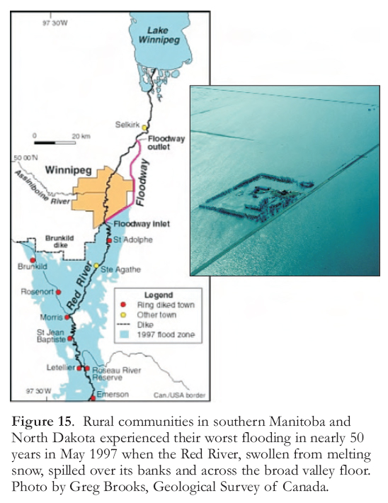
Display large image of Figure 15
57 Severe flooding can also accompany hurricanes that reach Canada. The worst flood disaster in Canadian history occurred in October 1954, when Hurricane Hazel struck Toronto. The hurricane produced record precipitation, with an estimated 210 mm of rain falling over a 36-hour period on the watersheds in the Toronto region (Andrews 1993). The deluge caused the most severe flooding in over 200 years. Because there was considerable urban development on most of the affected flood-plains, flood damage was high, estimated at over $150 million. More than 20 bridges were destroyed, 81 lives were lost, and almost 1900 families were left homeless (Andrews 1993).
SEVERE WEATHER
Hurricanes
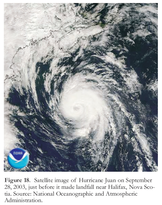
58 Hurricanes are primarily a threat to the Atlantic provinces, although, as mentioned earlier, weakened hurricanes can cause severe flooding in south-central Canada. Damage and loss of life from hurricanes result from winds, storm surges, and flooding caused by heavy rainfall. Storm surges cause the greatest damage and are responsible for 90 percent of all hurricane-related fatalities in the United States (Flanagan 1993). A storm surge is a local rise in sea level that occurs when hurricane winds drive seawater inland. Tropical cyclones commonly generate storm surges of over 3 m, and surges of 12 m or more have been recorded in Bangladesh and Australia (Burt 2004). Higher storm surges develop on broad, shallow coastlines where the forward motion of wind-driven water is impeded by friction. Storm surge and wind damage in the Northern Hemisphere are greatest in the right, forward quadrant of the storm as it makes land-fall−this is the direction the storm is travelling and also rotating, thus the wind speed at the ground is higher there than on the other side of the eye of the hurricane. The height of the surge will also be greater if the hurricane comes onto land at high tide. Hurricane Juan (Fig. 18), which struck Halifax with peak winds of about 160 km/hr on September 29, 2003, was a harsh reminder that Atlantic Canada is vulnerable to tropical storms. It killed eight people and caused more than $200 million in damage in Nova Scotia and Prince Edward Island, including major damage to trees and property in the urban core of Halifax.
Figure 16. The Red River Floodway was built after the river flooded Winnipeg in 1951. The photograph shows the control structure at the south end of the city that diverts part of the Red River flow into the Floodway. Photo by Greg Brooks, Geological Survey of Canada.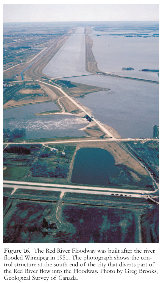
Display large image of Figure 16
Tornadoes
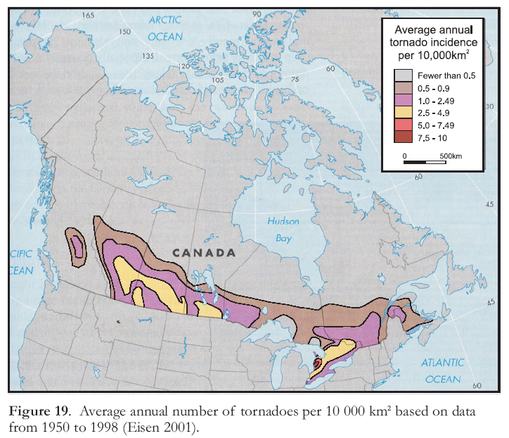
59 Tornadoes are much more common in the midwestern United States and southern Canada than elsewhere in the world, largely because the flat, low topography of central North America allows subtropical and arctic air masses to interact. The southern and central United States, in particular, has just the right combination of weather, topography, and geographic location to make it a perfect spawning ground for tornadoes (Grazulis 2001). Most US and Canadian tornadoes occur in spring and summer in the region extending from Florida to Texas and north to southern Alberta, Saskatchewan, Manitoba, and Ontario (Fig. 19; Environment Canada 2004b).
60 The most deadly tornado in Canadian history occurred in central Alberta on the afternoon of July 31, 1987. The tornado, rated F4 on the Fujita scale, ripped through Edmonton, killing 27 people and injuring 300 more; property damage amounted to $330 million. The tornado remained on the ground for almost an hour, achieving wind speeds of up to 460 km/hr and cutting a path of destruction 40 km long and up to 1 km wide (Charlton et al. 1997). Other recent deadly tornadoes in Canada include a F3 event that travelled across Pine Lake, Alberta, and into a trailer park in July 2000 (11 people killed, 132 injured); and a F4 tornado that struck Barrie, Ontario, in May 1985 (more than 800 people were left homeless, 8 people died, and 60 were seriously injured).
Other Meteorological Hazards
Blizzards
61 The official threshold for blizzard conditions in Canada is winds in excess of 40 km/hr, with visibilities of less than 1 km for at least four hours (Environment Canada 2002). A blizzard may also occur without snowfall−‘ground blizzards’ rework existing snow to produce whiteout conditions with visibility limited to a few metres or less. The Saskatchewan blizzard of 1947 lasted for 10 days and buried an entire train in a 1-km-long snowdrift that was up to 8 m deep (Environment Canada 2004a). Another famous storm, the ‘Blizzard of 1888,’ killed more than 400 people and paralyzed the northeastern United States for three days with snow drifts that reportedly covered the first floors of many buildings. East coast blizzards commonly occur during ‘nor’easters’, which derive their name from continuously blowing northeasterly winds that precede the storm. Nor’easters wreak havoc, with hurricane-force winds, heavy snowfall, and high waves.
Hailstorms
62 Large hailstones from severe thunderstorms pose a hazard to property in parts of southern Canada. Starting with a small ice pellet as a nucleus, a hailstone attracts a coating of liquid water in the lower part of the storm and that coating freezes when a strong updraft carries the stone upward, back into cold air. This process is repeated many times, forming a large nodule of ice. The annual damage caused by hail in the United States and Canada averages over $1 billion (Burt 2004). In Canada, damaging hailstorms are most common in the southern prairies, especially in Alberta.
Figure 19. Average annual number of tornadoes per 10 000 km2 based on data from 1950 to 1998 (Eisen 2001).Ice storms
63 Ice storms occur when rain at a temperature near 0°C instantly freezes as it comes into contact with colder surfaces. They typically occur during the winter months on the north side of a stationary or warm front when three conditions are met:
- An ample source of moisture is present in the warm air mass south of the front;
- Warm air overlies a shallow layer of cold air; and
- Objects on the land surface are at or below freezing (Keller et al. 2008).
64 Snow begins to fall from the colder, upper part of the warm air mass and then melts as it passes through the warmer air below. The resulting raindrops then become super-cooled as they pass through the near-surface cold air and freeze on contact with colder objects, such as roads, trees, and utility lines.
65 The worst Canadian ice storm of the last century occurred in January 1998 (Government of Québec 1999). After five days of freezing rain, parts of Québec, Ontario, New Brunswick and the northeastern United States were crippled by up to 10 cm of accumulated ice, leading to the collapse of steel power transmission towers, power poles, and trees. People throughout the affected region were without electricity, water, and phone service, in some cases for weeks. More than 5 million people were affected by blackouts, and at least 35 people died, mostly in Québec, as a result of house fires, falling ice, carbon monoxide poisoning, and hypothermia.
Drought
66 Over one billion people live in semi-arid regions of the world where droughts are common, and over 100 million people are at risk of malnutrition or death if drought causes their crops to fail (Keller et al. 2008). In Canada, southern Alberta and southern Saskatchewan, Canada’s most important grain-producing region, are the most vulnerable parts of the country to drought. Direct and indirect losses from drought in Canada, mainly to agriculture but also reduced hydroelectric power production, amount to more than $1 billion each year (Keller et al. 2008).
67 Prolonged droughts, lasting many years, have taken particularly severe economic and personal tolls. Most of us are aware of the dry hot weather of the 1930s, when crops in the midwestern United States and southern Canada failed and thousands of farms were abandoned. However, climate reconstructions from the southern Canadian prairies, based on tree-ring evidence, show that there have been longer and more severe droughts in the past 500 years (St. George et al. 2009). Longer proxy records of climate on the prairies, derived from studies of lake sediments and their pollen and other fossils, have also revealed frequent periods of drought during the Holocene (Vance et al. 1993, 1997; Lemmen et al. 1997; Leavitt et al. 1999).
Heat waves
68 Much of the world is vulnerable to heat waves, which are periods of extreme heat that are both longer and hotter than normal. In recent years, heat waves have killed an average of about 220 people per year in the United States and Canada, which is about the same as total deaths from flooding, lightning, tornadoes, and hurricanes combined (Keller et al. 2008). Most summer heat waves in Canada are associated with high-pressure ridges. Conditions west of the ridge are generally wet, whereas sunny and dry weather prevails to the east. If the ridge remains stationary for several days, air temperatures below the ridge may rise, triggering a heat wave. The air can be either humid or extremely dry during heat waves; a combination of high temperature and high humidity can produce a humidex value (a measure of the body’s perception of air temperature) in the high 40s (°C), which is extremely dangerous.
COASTAL EROSION AND SEA-LEVEL RISE
69 Many towns and cities in Canada are located on, or near, coasts and are therefore vulnerable to sea-level rise and erosion by waves. Fewer than 20 000 people live on Canada’s Arctic coast, so coastal hazards directly affecting people are much less of a problem there than elsewhere in the country. Demographic trends indicate that more than half of Canada’s population will eventually be concentrated along the Pacific and Atlantic sea coasts and along the shores of the Great Lakes.
70 Shorelines in Canada that are most vulnerable to erosion are those backed by Quaternary sediments (Clague and Bornhold 1980; Clague 1989; Shaw et al. 1998). Coastal areas notable for such sediments include the Strait of Georgia in British Columbia, parts of Graham Island in Haida Gwaii, Lake Ontario, Lake Winnipeg, and parts of Nova Scotia. Although sea ice limits fetch and therefore reduces wave erosion (fetch length over open water combined with wind speed determines wave size) throughout much of the central and northern Arctic, erosion rates of up to 2 m/yr have been observed in the western Arctic, e.g. along parts of the Beaufort Sea shoreline (Shaw et al. 1998). A developing problem in the Arctic that is not an issue elsewhere is thawing of permafrost. The Arctic has warmed significantly over the past several decades. This warming, together with wave erosion and sea-level rise, has eroded ice-rich coastal sediments and triggered active layer detachment failures. Some Inuit villages are threatened by the erosion and may have to be relocated at considerable cost.
71 Erosion on the Atlantic coast is aggravated by hurricanes and other severe storms, by sea-level rise, and by human interference with natural shore processes. Some shorelines in Atlantic Canada, where sea level is rising more rapidly than elsewhere in North America, are retreating at rates of up to 10 m/yr (Forbes et al. 1989). Sea-level rise in this region is due, in part, to continuing crustal subsidence associated with the disappearance of the Laurentide Ice Sheet. The ice sheet displaced viscous material in the mantle away from the centre of loading toward the periphery, creating an uplifted bulge beneath Atlantic Canada. When the ice sheet melted, the uplifted bulge collapsed and the land beneath Atlantic Canada subsided. It continues to do so today, although at a slower rate than during deglaciation. This process is augmenting the rise in global (eustatic) sea level caused by melting of glaciers and thermal expansion of upper ocean waters, and is contributing to coastal erosion in some areas of Atlantic Canada. In contrast, coastal areas around Hudson Bay and the Arctic Islands are experiencing isostatic uplift due to late Pleistocene and early Holocene deglaciation, which is offsetting eustatic sea-level rise (Andrews 1970; Gough and Robinson 2000).
72 Worldwide, sea level is rising at a rate of about 2 mm/yr. Scientists predict that sea level will rise several tens of centimetres, and perhaps considerably more, over the remainder of this century (Parry et al. 2007). Whatever the exact amount, coastal erosion will become an even greater problem than it is today. Sea-level rise will also threaten low-lying coastal areas with inundation (Clague 1989). Areas at greatest risk of inundation are delta plains, e.g. the Fraser River delta south of Vancouver, and coastal wetlands. Initially, inundation by the sea is likely to occur during severe cyclonic storms that temporarily raise sea level, and at times of unusually high tides. The Fraser River delta plain, on which nearly 300 000 people now live, is protected from the sea by an extensive system of dikes, but these structures will have to be strengthened and raised if sea level continues to rise as expected.
RISK IN THE TWENTY-FIRST CENTURY
73 Risk from natural hazards is expected to increase in Canada through the remainder of this century. The frequency of hazardous events caused by internal Earth forces − earthquakes, tsunami, and volcanic eruptions – probably will not change, but Canada’s vulnerability to them will likely increase due to population growth and concentration of wealth in hazard-prone areas such as Vancouver. In effect, the hazard does not change, but vulnerability, and therefore risk, increase.
74 This generalization may not apply to landslides and to hydro-meteorological hazards, including severe storms, hailstorms, ice storms, floods, drought, and heat waves. The frequency and magnitude of these processes could change if, as expected, climate continues to warm. Some scientists have suggested that hurricanes may become more frequent and powerful later in this century as near-surface waters in the Atlantic Ocean and Caribbean Sea warm (Parry et al. 2007). In such cases, both the hazard and vulnerability increase, causing a much higher level of risk in some areas.
75 Climate warming poses other hazards to Canada. Sea-level rise and stronger, more frequent storms could inundate low-lying coastal areas and accelerate erosion of some shorelines. Thaw of the permafrost in the Arctic is a potentially serious problem for Canadians living in the north because it is accompanied by irregular settlement of the ground and increases in thaw-layer detachment failures. A related problem is accelerated erosion of ice-rich coastlines bordering the Arctic Ocean. Parts of the west may experience more precipitation and more intense rainfall, both of which are important triggers of landslides. In contrast, much of southern Canada may experience more frequent and more severe droughts, accompanied by an increase in wildfires and reduced agricultural output.
76 Risk may also increase because of human activities and decisions. The continued development of the Fraser River floodplains east of Vancouver, encroaching settlement of steep slopes in mountain valleys of western Canada, and settlement of fire-prone areas at the urban–wildland interface are examples of trends that are increasing our exposure to natural hazards. Deforestation and overgrazing reduce or eliminate roots that stabilize the soil cover, increasingly the likelihood of landslides, erosion, stream siltation, and flooding.
77 As we reflect on future trends in risk in Canada, it is important to note two opposite historical trends at play in the developed world. First, the costs associated with natural disasters have increased exponentially during the past few decades (Fig. 1). Increased concentrations of wealth in hazard-prone urban areas, poor preparedness, and lack of understanding and awareness of hazards have contributed to this increase. Second, deaths and injuries from natural disasters in North America have decreased dramatically in the past century. This positive trend, in the case of earthquakes, is attributable to much improved engineering design, and in the case of floods and severe storms to better weather forecasting, improved communication of impending disasters, and land-use regulations. Good governance plays a vital role in all cases by enforcing construction standards and legislating land use and emergency preparedness.
78 Unfortunately, the reduction in deaths and injuries from natural disasters in the developed world is not yet being matched in the developing world, as shown by the horrific loss of life from the Indian Ocean tsunami in 2004 (225 000 deaths), the Pakistan earthquake of 2005 (80 000 deaths), the Wenchuan earthquake of 2008 (80 000 deaths), and especially the Haiti earthquake of January 2010 (ca. 230 000 deaths). It is the poorer, less developed countries that are bearing the brunt of natural disasters.
ACKNOWLEDGEMENTS
We thank John Cassidy for providing the map reproduced as Figure 2, Greg Brooks for the providing the photographs in Figures 15 and 16, and Alastair Dawson, Lionel Jackson, Baolin Wang, and Jim Teller for review comments. This paper is ESS Contribution No. 20090161.REFERENCES
Abromelt, D., Deveraux, A.M., and Over-by, D., 2004, Avalanche basics: United States Forest Service, National Avalanche Centre, [http://www.fsavlanche.org], accessed 16 July 2009.
Adams, J., and Basham, P., 1989, The seismicity and seismotectonics of Canada east of the Cordillera: Geoscience Canada, v. 16, p. 3-16.
Adams, J., and Basham, P., 2001, Seismicity and seismic hazards, in Brooks, G.R., ed., A Synthesis of Geological Hazards in Canada: Geological Survey of Canada, Bulletin 548, p. 7-25.
Andrews, J., 1993, Flooding−Canada Water Book: Environment Canada, Ottawa, ON, 171 p.
Andrews, J.T., 1970, Present and postglacial rates of uplift for glaciated northern and eastern North America derived from postglacial uplift curves: Canadian Journal of Earth Sciences, v. 7, p. 703-715.
Atwater, B.F., and Hemphill-Haley, E., 1997, Recurrence Intervals for Great Earthquakes of the Past 3500 years at Northeastern Willapa Bay, Washington: United States Geological Survey, Professional Paper 1576, 108 p.
Atwater, B.F., Nelson, A.R., Clague, J.J., Carver, G.A., Yamaguchi, D.K., Bobrowsky, P.T., Bourgeois, J., Darienzo, M.E., Grant, W.C., Hemphill-Haley, E., Kelsey, H.M., Hacoby, G.C., Nishenko, S.P., Palmer, S.P., Peterson, C.D., and Reinhart, M.A.,1995, Summary of coastal geologic evidence for past great earthquakes at the Cascadia subduction zone: Earthquake Spectra, v. 11, p. 1-18.
Atwater, B.F., Musumi-Rokkaku, S., Satake, K., Tsuji, Y., Ueda, K., and Yamguchi, D.K., 2005, The Orphan Tsunami of 1700: Japanese Clues to a Parent Earthquake in North America: United States Geological Survey, Professional Paper 1707, 133 p.
Berninghausen, W.H., 1968, Tsunamis and Seismic Seiches Reported from the Western North and South Atlantic and the Coast Waters of Northwestern Europe: United States National Oceanographic Office, Informal Report 68-85, 49 p.
Bolt, B.A., 2003, Earthquakes (5th edition): W.H. Freeman & Co., New York, 378 p.
Bondevik, S., Svendsen, J.I., Johnsen, G., Mangerud, J., and Kaland, P.E., 1997, The Storegga tsunami along the Norwegian coast, its age and runup: Boreas, v. 26, p. 29-53.
Bornhold, B.D., Harper, J.R., McLaren, D., and Thomson, R.E., 2007, Destruction of the First Nations village of Kwalate by a rock avalanche-generated tsunami: Atmosphere-Ocean, v. 45, p. 123-128.
Brooks, G.R. ed., 2001, A Synthesis of Geological Hazards in Canada: Geological Survey of Canada, Bulletin 548, 281 p.
Brooks, G.R., Evans, S.G., and Clague, J.J., 2001, Floods, in Brooks, G.R., ed., A Synthesis of Geological Hazards in Canada: Geological Survey of Canada, Bulletin 548, p. 101-143.
Brooks, G.R., St. George, S., Lewis, C.F.M., Medioli, B.E., Nielsen, E., Simpson, S., and Thorleifson, L.H., 2003, Geoscientific Insights into Red River Flood Hazards in Manitoba: Geological Survey of Canada, Open-File Report 4473, 35 p.
Bucknam, R.C., Hemphill-Haley, E., and Leopold, E.G., 1992, Abrupt uplift within the past 1700 years at southern Puget Sound, Washington: Science, v. 258, p. 1611-1614.
Burt, C.C. 2004. Extreme Weather: A Guide and Record Book: W.W. Norton, New York, 304 p.
Charlton, R.B., Kachman, B.M., and Wojtiw, L., 1997, Atlas of the Edmonton tornado and hailstorm: [http://www.iassistdata.org/tornado/t87.html], accessed November 3, 2009.
Chasse, J., El-Sabh, M.I., and Murty, T.S., 1993, A numerical model for water level oscillations in the St. Lawrence Estuary, Canada, Part 2: Tsunamis: Marine Geodesy, v. 16, p. 125-148.
Clague, J.J., 1989, Sea levels on Canada’s Pacific coast: Past and future trends: Episodes, v. 12, p. 29-33.
Clague, J.J., 1991, Natural hazards, Chapter 21 in Gabrielse, H., and Yorath, C.J., eds., Geology of the Cordilleran Orogen in Canada: Geological Survey of Canada, Geology of Canada, v. 4, p. 803-815 (also Geological Society of America, The Geology of North America, v. G-2).
Clague, J.J., 1996, Paleoseismology and Seismic Hazards, Southwestern British Columbia: Geological Survey of Canada, Bulletin 494, 88 p.
Clague, J.J., 1997, Evidence for large earthquakes at the Cascadia subduction zone: Reviews of Geophysics, v. 35, p. 439-460.
Clague, J.J., 2001, Tsunamis, in Brooks, G.R., ed., A Synthesis of Geological Hazards in Canada: Geological Survey of Canada, Bulletin 548, p. 27-42.
Clague, J.J., 2002, The earthquake threat in southwestern British Columbia: A geologic perspective: Natural Hazards, v. 26, p. 7-34.
Clague, J.J., and Bobrowsky, P.T., 1994a, Tsunami deposits beneath tidal marshes on Vancouver Island, British Columbia: Geological Society of America Bulletin, v. 106, p. 1293-1303.
Clague, J.J., and Bobrowsky, P.T., 1994b, Evidence for a large earthquake and tsunami 100-400 years ago on western Vancouver Island, British Columbia: Quaternary Research, v. 41, p. 176-184.
Clague, J.J., and Bobrowsky, P.T., 1999, The geological signature of great earthquakes off Canada’s west coast: Geo-science Canada, v. 26, p. 1-15.
Clague, J.J., and Bornhold, B.D., 1980, Morphology and littoral processes of the Pacific coast of Canada, in S.B McCann, ed., The Coastline of Canada, Littoral Processes and Shore Morphology: Geological Survey of Canada, Paper 80-10, p. 339-380.
Clague, J.J., and Evans, S.G., 1994, Formation and Failure of Natural Dams in the Canadian Cordillera: Geological Survey of Canada, Bulletin 464, 35 p.
Clague, J.J., and Evans, S.G., 2000, A review of catastrophic drainage of moraine-dammed lakes in British Columbia: Quaternary Science Reviews, v. 19, p. 1763-1783.
Clague, J., and Turner, R., 2003, Vancouver, city on the Edge: Living with a Dynamic Geological Landscape: Tricouni Press, Vancouver, BC, 192 p.
Clague, J.J., Hutchinson, I., Mathewes, R.W., and Patterson, R.T., 1999, Evidence for late Holocene tsunamis at Catala Lake, British Columbia: Journal of Coastal Research, v. 15, p. 45-60.
Clague, J.J., Bobrowsky, P.T., and Hutchinson, I., 2000, A review of geological records of large tsunamis at Vancouver Island, British Columbia: Quaternary Science Reviews, v. 19, p. 849-863.
Clague, J.J., Munro, A., and Murty, T., 2003, Tsunami hazard and risk in Canada: Natural Hazards, v. 28, p. 433-461.
Clague, J., Yorath, C., Franklin, R., and Turner, B., 2006, At Risk: Earthquakes and Tsunamis on the West Coast: Tricouni Press, Vancouver, BC, 200 p.
Costa, J.E., and Schuster, R.L., 1988, The formation and failure of natural dams: Geological Society of America Bulletin, v. 100, p. 1054-1068.
Cruden, D.M., and Krahn, J., 1973, A reexamination of the geology of the Frank Slide: Canadian Geotechnical Journal, v. 10, p. 581-591.
Dawson, A.G., Long, D., and Smith, D.E., 1988, The Storegga Slides: Evidence from eastern Scotland for a possible tsunami: Marine Geology, v. 82, p. 2271-2276.
Dragert, H., Hyndman, R.D., Rogers, G.C., and Wang, K., 1994, Current deformation and the width of the seismogenic zone of the northern Cascadia subduction thrust: Journal of Geophysical Research, v. 99, p. 653-668.
Eisen, C., 2001, A Canadian Tornado Climatology for the Period 1950 to 1997: Wilfrid Laurier University Press, Waterloo, ON.
Environment Canada, 2002, Blizzards: [http://www.pnr-rpn.ec.gc.ca/air/wintersevere/blizzards.en.html], accessed 16 July 2009.
Environment Canada, 2004a, Blizzards and winter weather hazards: [http://www.msc-smc.ec.gc.ca/cd/brochures/blizzard_e.cfm], accessed 16 July 2009.
Environment Canada, 2004b, Tornadoes: [http://www.pnrrpn.ec.gc.ca/air/summersevere/ae00s02.en.html], accessed 16 July 2009.
Evans, S.G. 1999, Landslide Disasters in Canada 1840-1998: Geological Survey of Canada, Open File 3712 (map with marginal notes).
Evans, S.G., 2001, Landslides, in Brooks, G.R., ed., A Synthesis of Geological Hazards in Canada: Geological Survey of Canada, Bulletin 548, p. 43-79.
Filion, L., Quinty, F., and Bégin, C., 1991, A chronology of landslide activity in the valley of Riviere du Gouffre, Charlevoix, Québec: Canadian Journal of Earth Sciences, v. 28, p. 250-256.
Fine, I.V., Rabinovich, A.B., Bornhold, B.D., Thomson, R.E., and Kulikov, E.A., 2005, The Grand Banks landslide-generated tsunami of November 18, 1929: Preliminary analysis and modeling: Marine Geology, v. 215, p. 45-57.
Flanagan, R., 1993, Beaches on the brink: Earth, v. 2, p. 24-33.
Forbes, D.L., Taylor, R.B., and Shaw, J., 1989, Shorelines and rising sea levels in eastern Canada: Episodes, v. 12, p. 23-28.
Gough, W.A., and Robinson, C.A., 2000, Sea-level variation in Hudson Bay, Canada, from tide-gauge data: Arctic, Antarctic, and Alpine Research, v. 32, p. 331-335.
Government of Québec, 1999, Facing the Unforeseeable: Lessons from the Ice Storm of ’98: Publications du Québec, Montreal, QC.
Grazulis, T.P., 2001, The Tornado, Nature’s Ultimate Windstorm: University of Oklahoma Press, Norman, OK, 324 p.
Hare, F.K., and Hay, J.E., 1974, The climate of Canada and Alaska, in Bryson, R.A., and Hare, F.K., eds., The Climates of North America: Elsevier, Amsterdam, p. 49-192.
Hare, F.K., and Thomas, M.K., 1974, Climate Canada: Wiley, Toronto, ON, 256 p.
Heezen, B.C., and Ewing, M., 1952, Turbidity currents and submarine slumps and the Grand Banks, Newfoundland, earthquake: American Journal of Science, v. 250, p. 849-873.
Hickson, C.J., and Edwards, B.R., 2001, Volcanoes and volcanic hazards, in G.R. Brooks, ed., A Synthesis of Geological Hazards in Canada: Geological Survey of Canada, Bulletin 548, p. 145-181.
Hutchinson, I., Clague, J.J., and Mathewes, R.W., 1997, Reconstructing the tsunami record on an emerging coast: A case study of Kanim Lake, Vancouver Island, British Columbia: Canada. Journal of Coastal Research, v. 13, p. 545-553.
Hutchinson, I., Guilbault, J.-P., Clague, J.J., and Bobrowsky, P.T., 2000, Tsunamis and tectonic deformation at the northern Cascadia margin: A 3000 year record from Deserted Lake, Vancouver Island, British Columbia: The Holocene, v. 10, p. 429-439.
Hyndman, R.D., 1995, Giant earthquakes of the Pacific Northwest: Scientific American, v. 273, p. 68-75.
Hyndman, R.D., and Wang, K., 1995, The rupture zone of Cascadia great earthquakes from current deformation and the thermal regime: Journal of Geophysical Research, v. 100, p. 22 133-22 154.
Hyndman, R.D., Rogers, G.C., Dragert, H., Wang, K., Clague, J.J., Adams, J., and Bobrowsky, P.T., 1996, Giant earthquakes beneath Canada’s west coast: Geoscience Canada, v. 23, p. 63-72.
International Association of Volcanology and Chemistry of the Earth’s Interior, Subcommittee on Decade Volcanoes, 1994, Research at decade volcanoes aimed at disaster prevention: Eos, Transactions of the American Geophysical Union, v. 7, p. 340-350.
Jackson, L.E., Jr., 2002, Regional landslide activity and Quaternary landscape evolution, Rocky Mountain Foothills, Alberta, Canada, in Evans, S.G., and DeGraff, J.V., eds., Catastrophic Landslides: Effects, Occurrence, and Mechanisms: Geological Society of America, Reviews in Engineering Geology, v. 15, p. 325-344.
Jackson, L.E., Church, M., Clague, J.J., and Eisbacher, G.H., 1985, Slope hazards in the southern Coast Mountains of British Columbia, Field trip 4, in Tempelman-Kluit, D.J., ed., Field Guides to Geology and Mineral Deposits in the Southern Canadian Cordillera: Geological Society of America, Cordilleran Section Annual Meeting, Vancouver, BC, p. 4.1-4.34.
Jakob, M., and Weatherly, H., 2003, A hydroclimatic threshold for landslide initiation on the North Shore Mountains of Vancouver, British Columbia: Geomorphology, v. 54, p. 137-156.
Jamieson, B., 2001, Snow avalanches, in Brooks, G.R., ed., A Synthesis of Geological Hazards in Canada: Geological Survey of Canada, Bulletin 548, p. 81-100.
Jamieson, B., 2006, Formation of refrozen snowpack layers and their role in slab avalanche release: Reviews of Geophysics, v. 44, RG2001.
Jefferies, M., and Been, K., 2006, Soil Liquefaction: A Critical State Approach: Taylor & Francis, London, 512 p.
Johns, M.W., Prior, D.B., Bornhold, B.D., Coleman, J.M., and Bryant, W.R., 1986, Geotechnical aspects of a submarine slope failure, Kitimat fjord, British Columbia: Marine Geotechnology, v. 6, p. 243-279.
Keller, E.A., Blodgett, R.H., and Clague, J.J., 2008, Hazards: Earth’s Processes, Disasters, and Catastrophes: Pearson Prentice Hall, Toronto, ON, 448 p.
Kelsey, H.M., Nelson, A.R., Hemphill-Haley, E., and Witter, R.C., 2005, Tsunami history of an Oregon coastal lake reveals a 4600 yr record of great earthquakes on the Cascadia subduction zone: Geological Society of America Bulletin, v. 117, p. 1009-1032.
Lamontagne, M., 2002, An overview of some significant Eastern Canadian earthquakes and their impacts on the geological environment, buildings and the public: Natural Hazards, v. 26, p. 55-67.
Lander, J.F., 1996, Tsunamis Affecting Alaska, 1737-1996: United States Department of Commerce, National Geophysical Data Center, Boulder, CO, 195 p.
Leavitt, P.R., Vinebrooke, R.D., Hall, R.I., Wilson, S.E., Smol, J.P., Vance, R.E., and Last, W.M., 1999, Multiproxy record of prairie lake response to climate change and huiman activity, Clearwater Lake, Saskatchewan, in Lemmen, D.S., and Vance, R.E., eds., Holocene Climate and Environmental Change in the Palliser Triangle: A Geoscientific Context for Evaluation of the Impacts of Climate Change on the Southern Canadian Prairies: Geological Survey of Canada, Bulletin 534, p. 125-138.
Lemmen, D.S., Vance, R.E., Wolfe, S.A., and Last, W.M., 1997, Impacts of future climate change on the southern Canadian prairies: A paleoenviron-mental perspective: Geoscience Canada,.v. 24, p. 121-133.
Liverman, D., Batterson, M., Taylor, D., and Ryan, J., 2001, Geological hazards and disasters in Newfoundland and Labrador: Canadian Geotechnical Journal, v. 38, p. 936-956.
Lliboutry, L., Morales Arnao, B., Pautre, A., and Schneider, B., 1977, Glaciological problems set by the control of dangerous lakes in Cordillera Blanca, Peru: Journal of Glaciology, v. 18, p. 239-254.
Mathews, W.H., 1965, Two self-dumping ice-dammed lakes in British Columbia: Geographical Review, v. 55, p. 46-52.
Mathews, W.H., 1979, Landslides of central Vancouver Island and the 1946 earthquake: Bulletin of the Seismological Society of America, v. 69, p. 445-450.
Mathews, W.H., and Clague, J.J., 1993, The record of jökulhlaups from Summit Lake, northwestern British Columbia: Canadian Journal of Earth Sciences, v. 30, p. 499-508.
Mathews, W.H., and McTaggart, K.C., 1978, Hope rockslides, British Columbia, Canada, in Voight, B., ed., Rock-slides and Avalanches, 1: Natural Phenomena: Elsevier Scientific Publishing Co., New York, p. 259-275.
McClung, D.M., and Schaerer, P.A., 1993, The Avalanche Handbook: The Mountaineers, Seattle, WA, 284 p.
McConnell, R.G., and Brock, R.W., 1904, Report on the great landslide at Frank, Alberta: Annual Report of the Department of Interior for the Year 1902-1903, Part VIII, 17 p.
Milne, W.G., Rogers, G.C., Riddihough, R.P., McMechan, G.A., and Hyndman, R.D., 1978, Seismicity of western Canada: Canadian Journal of Earth Sciences, v. 15, p. 1170-1193.
Mollard, J.D., 1977, Regional landslide types in Canada: Geological Society of America, Reviews in Engineering Geology, v. 3, p. 29-56.
Morrall, J.F., and Abdelwahab, W.M., 1992, Estimating traffic delays and the economic cost of recurrent road closures on rural highways: Logistics and Transportation Review, v. 29, p. 159-177.
Munich Reinsurance Company of Canada, 1992, A Study of the Economic Impact of a Severe Earthquake in the Lower Mainland of British Columbia: Munich Reinsurance Company of Canada, Toronto, ON, 100 p.
Murty, T.S., 1977, Seismic Sea Waves − Tsunamis: Fisheries Board of Canada, Bulletin 198, 337 p.
Murty, T.S., 1979, Submarine slide-generated water waves in Kitimat Inlet, British Columbia: Journal of Geophysical Research, v. 84, p. 7777-7779.
Murty, T.S., and Boilard, L., 1970, The tsunami in Alberni Inlet caused by the Alaska earthquake of March 1964, in Mansfield, W.M., ed., Tsunamis in the Pacific Ocean: Proceedings, International Symposium on Tsunamis and Tsunami Research, East-West Center Press, Honolulu, HI, p. 165-187.
Nelson, A.R., Atwater, B.F., Bobrowsky, P.T., Bradley, L.-A., Clague, J.J., Carver, G.A., Darienzo, M.E., Grant, W.C., Kreuger, H.W., Sparks, R., Stafford, T.W. Jr., and Stuiver, M., 1995, Radio-carbon evidence for extensive plate-boundary rupture about 300 years ago at the Cascadia subduction zone: Nature, v. 378, p. 371-374.
Nelson, A.R., Kelsey, H.M., and Witter, R.C., 2006, Great earthquakes of variable magnitude at the Cascadia subduction zone: Quaternary Research, v. 65, p. 354-365.
Parry, M.L., Canziani, O.F., Palutikof, J.P., van der Linden, P.J., and Hanson, C.E., eds., 2007, Climate Change 2007: Impacts, Adaptation and Vulnerability: Contribution of Working Group II to the Fourth Assessment Report of the Intergovernmental Panel on Climate Change, Cambridge University Press, Cambridge, UK, 976 p.
Peters, R., Jaffe, B.E., and Gelfenbaum, G., 2007, Distribution and sedimentary characteristics of tsunami deposits along the Cascadia margin of western North America: Sedimentary Geology, v. 200, p. 372-386.
Peterson, C.D., Barnett, E.T., Briggs, G.G., Carver, G.A., Clague, J.J., and Darienzo, M.E., 1997, Estimates of Coastal Subsidence from Great Earthquakes in the Cascadia Subduction Zone, Vancouver Island, B.C., Washington, Oregon, and Northernmost California: Oregon Department of Geology and Mineral Industries, Open File Report O-97-5, 44 p.
Piper, D.J.W., Shor, A.N., and Clarke, J.E.H., 1988, The 1929 ‘Grand Banks’ earthquake, slump, and turbidity current, in Clifton, H.E., ed., Sedimento-logic Consequences of Convulsive Geologic Events: Geological Society of America, Special Paper 229, p. 77-92.
Plafker, G., 1969, Tectonics of the March 27, 1964, Alaska Earthquake: United States Geological Survey, Professional Paper 543-I, 74 p.
Plafker, G., and Ericksen, G.E., 1978, Nevados Huascaran avalanches, Peru, in Voight, B., ed., Rockslides and Avalanches 1: Natural Phenomena: Elsevier Scientific Publishing Co., Amsterdam, p. 277-314.
Prior, D.B., Bornhold, B.D., Coleman, J.M., and Bryant, W.R., 1982, Morphology of a submarine slide, Kitimat Arm, British Columbia: Geology, v. 10, p. 588-592.
Prior, D.B., Bornhold, B.D., and Johns, M.W., 1984, Depositional characteristics of a submarine debris flow: Journal of Geology, v. 92, p. 707-727.
Rasmussen, P.E., and Gardner, H.D., 2008, Earth and health – Building a safer Canadian environment: Geoscience Canada, v. 35, p. 61-72.
Rogers, G.C., 1988, An assessment of the megathrust potential of the Cascadia subduction zone: Canadian Journal of Earth Sciences, v. 25, p. 844-852.
Rogers, G.C., and Hasegawa, H.S., 1978, A second look at the British Columbia earthquake of June 23, 1946: Bulletin of the Seismological Society of America, v. 68, p. 653-676,
Rogers, G.C., and Horner, R.B., 1991, An overview of western Canada seismicity, in Slemmons, D.B., Engdahl, E.R., Zobach, M., and Blackwell, D., eds., Neotectonics of North America: Geological Society of America, The Geology of North America, DMV-1, p. 69-76.
Rogers, G.C., and Souther, J.G., 1983, Hotspots trace plate movements: Geoscience Canada, v. 12, p. 10-13.
Satake, K., Shimazaki, K., Tsuji, Y., and Ueda, K., 1996, Time and size of a giant earthquake in Cascadia inferred from Japanese tsunami records of January 1700: Nature, v. 378, p. 246-249.
Sewell, W.R.D., 1969, Human response to floods, in Chorley, R.J., ed., Water, Earth, and Man: Methuen and Co., London, p. 431-451.
Shaw, J., Taylor, R.B., Forbes, D.L., Solomon, S., and Ruz, M.-H., 1998, Sensitivity of the Coasts of Canada to Sea-level Rise: Geological Survey of Canada, Bulletin 505, 79 p.
Skvortsov, A., and Bornhold, B., 2007, Numerical simulation of the landslide-generated tsunami in Kitimat Arm, British Columbia, Canada, 27 April 1975: Journal of Geophysical Research, v. 112, F02028.
Souther, J.G., 1970, Volcanism and its relationship to recent crustal movements in the Canadian Cordillera: Canadian Journal of Earth Sciences, v. 7, p. 553-568.
Souther, J.G., 1977, Volcanism and tectonic environments in the Canadian Cordillera; a second look, in Baragar, W.R.A., Coleman, L.C., and Hall, J.M., eds., Volcanic Regimes in Canada: Geological Association of Canada, Special Paper 16, p. 3-24.
St. George, S., Meko, D.M., Girardin, M.-P., MacDonald, G.M., Nielsen, E., Pederson, G.T., Sauchyn, D.J., Tardif, J.C., and Watson, E., 2009, The tree-ring record of drought on the Canadian Prairies: Journal of Climate, v. 22, p. 689-710.
Stethem, C., Jamieson, B., Schaerer, P., Liverman, D., Germain, D., and Walker, S., 2003, Snow avalanche hazard in Canada: A review: Natural Hazards, v. 28, p. 487-515.
Thomson, R.E., 1981, Oceanography of the British Columbia Coast: Canada Department of Fisheries and Oceans, Canadian Special Publication of Fish-eries and Aquatic Sciences, v. 56, 291 p.
Thurber Consultants Limited, 1983, Debris United States Geological Survey, 2005, Mount St. Helens − From the 1980 eruption to 2000: United States Geological Survey Fact Sheet 036-00, [http://pubs.usgs.gov/fs/2000/fs036-00/].
United States Geological Survey, 2009a, Earthquakes with 1,000 or more deaths since 1900: [http://earthquake.usgs.gov/earthquakes/world/world_deaths.php], accessed December 15, 2009.
United States Geological Survey, 2009b, Questions about super volcanoes: [http://volcanoes.usgs.gov/yvo/about/faq/faqsupervolcano.php#supervolcano], accessed November 3, 2009.
Vance, R.E., Clague, J.J., and Mathewes, R.W., 1993, Holocene paleohydrology of a hypersaline lake in southeastern Alberta: Journal of Paleolimnology, v. 8, p. 103-120.
Vance, R.E., Last, W.M., and Smith, A.J., 1997, Hydrologic and climatic implications of a multidisciplinary study of late Holocene sediment from Kenosee Lake, southeastern Saskatchewan, Canada: Journal of Paleolimnology, v. 18, p. 365-393.
VanDine, D.F., 1985, Debris flows and debris torrents in the southern Canadian Cordillera: Canadian Geotechnical Journal, v. 22, p. 44-68.
Whelan, M., 1994, The night the sea smashed Lord’s Cove: Canadian Geographic, v. 114, p. 70-73.
Wigen, S.O., and White, W.R., 1964, Tsunami of March 27-29, 1964, West Coast of Canada: Canada Department of Mines and Technical Surveys, Ottawa, ON, 6 p.
Wood, C.A., and Kienle, J., 1990, Volcanoes of North America: United States and Canada: Cambridge University Press, Cambridge, UK, 354 p.
Woods, J., 1983, Snow War: An Illustrated History of Rogers Pass, Glacier National Park (3rd edition): National and Provincial Parks Association of Canada, in cooperation with Parks Canada, 52 p.
Wright, T.L., and Pierson, T.C., 1992, Living with Volcanoes: United States Geological Survey, Circular 1073, 57 p.
