Series
International Year of Planet Earth 7.
Oceans: Submarine Landslides and Consequent Tsunamis in Canada
David C. MosherNatural Resources Canada / Ressources naturelles Canada, Geological Survey of Canada – Atlantic / Commission géologique du Canada - atlantique, 1 Challenger Drive (P.O. Box 1006) / 1 allée Challenger (C.P. 1006) Dartmouth, NS/N-É, B2Y 4A2
dmosher@nrcan.gc.ca
Submitted March 2009, Accepted as revised May 2009
SUMMARY
Canada has the longest coastline and largest continental margin of any nation in the World. As a result, it is more likely than other nations to experience marine geohazards such as submarine landslides and consequent tsunamis. Coastal landslides represent a specific threat because of their possible proximity to societal infrastructure and high tsunami potential; they occur without warning and with little time lag between failure and tsunami impact. Continental margin landslides are common in the geologic record but rare on human timescales. Some ancient submarine landslides are massive but more recent events indicate that even relatively small slides on continental margins can generate devastating tsunamis. Tsunami impact can occur hundreds of km away from the source event, and with less than 2 hours warning. Identification of high-potential submarine landslide regions, combined with an understanding of landslide and tsunami processes and sophisticated tsunami propagation models, are required to identify areas at high risk of impact.SOMMAIRE
Le Canada possède les plus longues zones côtières et marges continentales du monde. Donc, il est significativement exposé aux géorisques marins, comme les glissements de terrain sousmarins (GTSM) comportent également des risques de tsunamis. Les glissements côtiers représentent un risque significatif vu la proximité d’infrastructures et leur capacité de produire des tsunamis. Ils se produisent sans aver-tissement et peu de délai existe entre leur déclenchement et l’impact possible d’un tsunami. Les GTSM en marge continentale sont communs dans l’histoire géologique mais rare à l’échelle de l’histoire humaine. Quelques anciens dépôts glissés sont de dimensions importantes, mais les nouvelles évidences suggèrent que même les petits glissements sur les marges continentales peuvent générer des tsunamis. L’impact des tsunamis peut être ressenti à des centaines de km de la source et l’impact est possible avec moins de 2 heures d’avertissement. L’identification des régions à potentiel élevé pour l’instabilité des pentes combinées à la compréhension des processus de formation de GTSM et de tsunami, et à des modèles sophistiqués de propagation, sont nécessaires pour identifier les secteurs hautement à risque d’impact.INTRODUCTION
1 A submarine landslide off Papua, New Guinea in 1998 caused a tsunami resulting in 2200 deaths (Tappin et al. 2001). On December 26, 2006, a submarine landslide off Taiwan, in the Luzon Strait, caused failure of seven out of nine undersea cables (LaPierre 2007; Hsu et al. 2009). These failures disrupted the entire internet network between Taiwan, Hong Kong, and China and affected communications with Thailand, Malaysia, Vietnam, South Korea and Singapore for 12 hours. Given that the combined GDP of Taiwan, Hong Kong and China approximates $7.56 billion dollars per day, the economic impact of this event was very severe. The complete cable inventory was not again operational until January 30th, 2007, after 18 cable repairs. These two events point to the potential devastation that submarine landslides can wreak. As a result, concerted efforts by various groups are underway to understand the risk these offshore phenomena represent to society; these groups include the United States Nuclear Regulatory Commission, the US National Tsunami Hazard Mitigation Program, the European Continental Slope Stability (COSTA) Program and associated Canadian Can-COSTA program, and the United Nations Educational Scientific and Cultural Organization’s (UNESCO) International Geological Correlation Program (IGCP) Project 511 on Submarine Mass Movements and Their Consequences (Mosher et al. 2009a; Lykousis et al. 2007; Locat and Meinert 2003).
2 This elevated awareness of the need for better understanding of underwater landslides is coupled with great advances in underwater mapping technologies developed over the past two decades. Multibeam sonar, 3D seismic reflection, and remote and autonomous underwater vehicle technologies provide hitherto unparalleled imagery of the geology beneath the oceans, permitting investigation of submarine landslide deposits in great detail. This paper reviews a number of known examples of underwater landslides in Canada, particularly those for which modern survey data exist, and separates the discussion into coastal and continental margin events. Some landslides are known to have caused tsunamis and so the tsunami potential of these events is assessed. The paper will also show the prevalence of landslide deposits in the offshore geologic record, which has implications concerning the frequency of underwater landslides and the modern hazard they represent.
COASTAL LANDSLIDES and TSUNAMIS
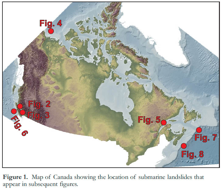
3 Canada’s coastline is >243 000 km long – the longest in the world (Fig. 1). Coastal landslides represent a clear hazard because of their high potential for tsunami generation and their possible proximity to societal infrastructure. Many coastal regions are characterized by one or more of the following factors that create conditions conducive to sediment mass-failure: 1) steep slopes caused by wave, long-shore current, and/or glacial erosion; 2) a variety of coastal Quaternary deposits that in many cases lack cohesive strength; 3) offshore sediments having either marine or lacustrine origins because of a history of sea level rise and fall; 4) juxtaposition of sediments with variable geotechnical properties; and 5) significant spatial and temporal variation in pore pressure because of the juxtaposition of subaerial and submarine conditions, tidal and wave fluctuations, and the possible presence of meteoric waters and aquifers.
Figure 1. Map of Canada showing the location of submarine landslides that appear in subsequent figures.
Display large image of Figure 1
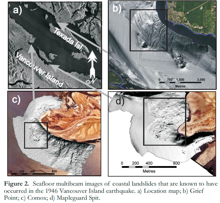
4 The coast of British Columbia (BC) is the region in Canada most prone to landslides and consequent tsunamis because of the conditions listed above, combined with a high potential for earthquakes (Bornhold et al. 2001; Adams and Halchuk 2003). The possibility of earthquake ground motion amplification is also high in areas of unconsolidated sediment accumulations (Mosher et al. 2000; Cassidy and Rogers 2004). The 1946 Vancouver Island M7.2 earthquake caused underwater landslides within the Strait of Georgia at Deep Bay, Goose Spit, and Grief Point (Mosher et al. 2004a; Fig. 2). The failure in Deep Bay is known to have caused a water wave that reportedly overturned a boat and resulted in one drowning (Rogers 1980). The Grief Point failure severed an underwater telephone cable running between Texada Island and the mainland. Rabinovich et al. (2003) simulated a hypothetical landslide in this area of Malaspina Strait; the simulation generated a tsunami with trough-to-crest heights of 6 to 8 m along the coast of Texada Island and wave heights of 1.5 to 2.0 m across the strait.
Figure 2. Seafloor multibeam images of coastal landslides that are known to have occurred in the 1946 Vancouver Island earthquake. a) Location map; b) Grief Point; c) Comox; d) Mapleguard Spit.
Display large image of Figure 2
5 A number of coastal landslides in BC have been caused by anthropogenic activity, such as the Kitimat Arm failure of 1975 that resulted from coastal construction (Prior et al. 1982). This slide produced a series of waves, the largest of which was an estimated 8.2 m high (Prior et al. 1982). In some cases, however, sediment mass failure occurs with no readily apparent trigger. Spontaneous failure in river-mouth deltas may be caused by rapid sediment loading (Terzaghi 1956); for example, a well-documented failure at the mouth of the Fraser River involved 106 m3 of sediment and retrogression of the head of the principal sea valley to within 100 m of the Sand Heads lighthouse (McKenna and Luternauer 1987; Atkins and Luternauer 1991; Christian et al. 1998). Similarly, some failures in coastal regions are perhaps related purely to pore pressure responses to tidal change or storm activity (Christian et al. 1997, 1998; Mosher et al. 2004a, b).
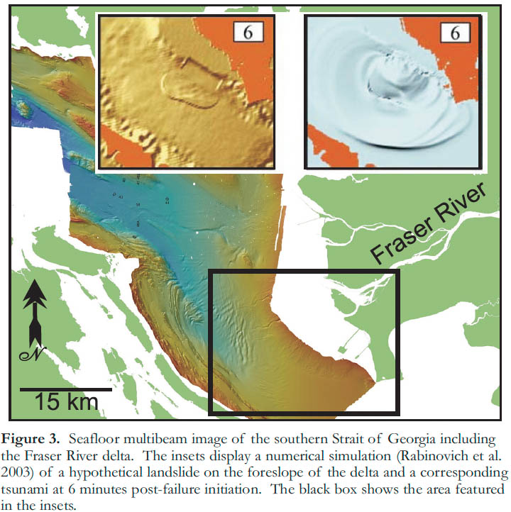
6 The tsunami potential of a failure on the Fraser River delta, irrespective of causal mechanism, was assessed by Rabinovich et al. (2003), who modeled the water column response to a hypothetical slide failure on the delta foreslope. Slide dimensions were based on geological evidence of a possible pre-historic failure (Mosher et al. 2004a). The model demonstrated a tsunami wave up to 18 m high crossing the Strait of Georgia within 6 minutes (Fig. 3) and striking the coast opposite the source area. Wave amplitudes were much smaller (1 to 4 m) on the mainland coast because of reflection of the initial waves from shallow water and intertidal delta banks.
Figure 3. Seafloor multibeam image of the southern Strait of Georgia including the Fraser River delta. The insets display a numerical simulation (Rabinovich et al. 2003) of a hypothetical landslide on the foreslope of the delta and a corresponding tsunami at 6 minutes post-failure initiation. The black box shows the area featured in the insets.
Display large image of Figure 3
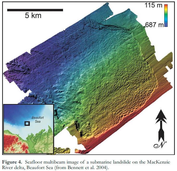
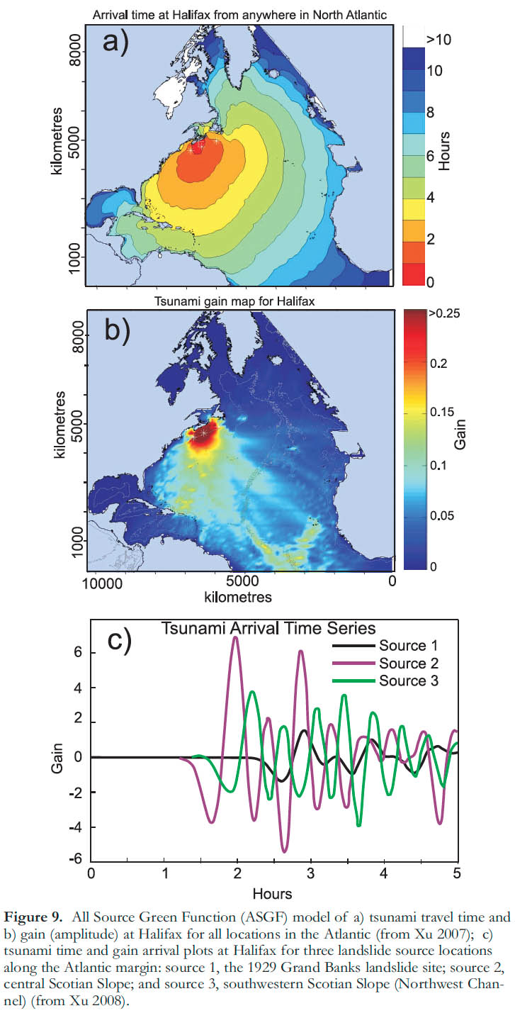
7 The MacKenzie River delta is the largest river delta in Canada, and is located in the Yukon-Beaufort-MacKenzie region, where seismicity potential is considered moderate (Adams and Atkinson 2003). The two largest recorded events were a M6.5 earthquake in 1920 and a M5 event in 1975 (Hyndman et al. 2005). The risk of submarine landsliding is significant because of this seismicity potential in combination with thick sediment accumulation and rapid sedimentation rates on the delta. In addition, earthquake ground acceleration amplification, variable permafrost thicknesses, and the presence of significant in situ gas and possible gas hydrate (Paull et al. 2007) must be taken into consideration in assessing the probability of submarine landsliding in the region of the delta.
8 Figure 4 shows a ~200 km2 submarine landslide of unknown age on the seafloor of the MacKenzie delta. This feature was studied by Hill et al. (1982) but without the benefit of modern multibeam sonar data (Bennett et al. 2004). Hill et al. (1982) concluded that the area is stable under present conditions (i.e. static – with no contributing triggers such as ground motion due to earthquakes), based on infinite slope stability analysis. Evidence of a mass failure, therefore, suggests that seismicity or elevated pore pressures were required to initiate failure. However, Hill et al. (1982) invoked sediment creep (slow downslope deformation) as a viable mechanism for initiation of mass failure in this region. The failure’s tsunami-generating capacity was not assessed, but multibeam sonar data (Fig. 4) show >80 m-high headwall escarpments in present water depths of 115 m, hence its tsunami-generating potential was probably high. For comparison, the tsunami simulation of Rabinovich et al. (2003) on the Fraser delta (discussed above) involved only 21 km2 and a volume of 0.75 km3. With offshore hydrocarbon development in the MacKenzie River delta region and extremely low terrain elevations in the adjacent hinterland, submarine landslide and tsunami potential poses a significant hazard in the Beaufort Sea.
Figure 4. Seafloor multibeam image of a submarine landslide on the MacKenzie River delta, Beaufort Sea (from Bennett et al. 2004).
Display large image of Figure 4
9 After British Columbia, the second most earthquake-prone area in Canada is the Laurentian Valley of Quebec (Lamontagne 2009; Mazzotti et al. 2005; Mazzotti 2007). Along the banks and submarine slope of the St. Lawrence estuary and the Saguenay Fjord are numerous examples of mass failure (Cauchon-Voyer et al. 2007; Levesque et al. 2006; Urgeles et al. 2001; Fig. 3). Most are prehistoric, but a few are relatively recent, such as the 1663 and ca. 1860 events (Cauchon-Voyer et al. 2007; Lamontagne 2009). It is unknown if these events produced tsunamis; however, in 1908 a landslide on the Liève River in western Québec produced a wave that inundated the village of Notre-Dame-de-la Salette and killed 27 people (Evans 2001).
10 Poncet et al. (2009) assessed the tsunami-generating capability of coastal landslides in the lower St. Lawrence River estuary. They investigated two cases, one of a mapped submarine landslide at St-Siméon, and the other a suture on the seafloor offshore Matane that suggests potential for a future landslide. They found that the greatest contributing factor to tsunami wave height in this environment was the water depth of slide initiation. An additional critical factor with respect to tsunami impact was the orientation of the failure relative to the axis of the river. In the case of St-Siméon, Poncet et al. (2009) modeled a 5 m-high tsunami wave striking the opposite coast within five minutes and propagating upriver (Fig. 5). Along the banks of the river and estuary, it is possible that a landslide could commence subaerially and enter the water catastrophically, as suggested for the Betsiamites slide of 1663 (Cauchon-Voyer et al. 2007). In such a case, it is possible to generate a significant tsunami, as surmised for a rockslide in Knight Inlet, BC that occurred sometime in the 1500s, in which the consequent tsunami destroyed the Kwalate First Nation village (Bornhold et al. 2007). A more recent tsunami occurred in 1958 in Lituya Bay, Alaska, where a subaerial rockfall fell into Gilbert Inlet, producing a wave that denuded the landscape at elevations up to an incredible 524 m above sea level (Miller 1960).
Figure 5. a) Seafloor multibeam image of a submarine landslide at St.-Siméon, Quebec, along the St. Lawrence River estuary; b) and c) a numerical simulation of a hypothetical tsunami that such a slide may have generated (from Poncet et al. 2009).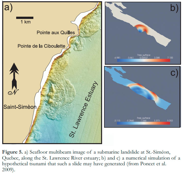
CONTINENTAL MARGIN LANDSLIDES AND TSUNAMIS
11 Canada’s landmass in water depths greater than 200 m (the approximate depth of the shelf break) and above the 3000 m isobath represents an area of 2 960 000 km2. This continental slope typically supports a stable, thick, unconsolidated sediment overburden (Mosher et al. 1994). Seabed slopes within this zone typically range between <1° and 4°, although canyon, channel wall and subduction thrust ridge slope angles can exceed 45° (Mosher et al. 2004c). Aside from slope angle conditions, other factors that increase the potential for slope instability include interstitial biogenic (natural) gas, gas hydrate, salt mobility, underconsolidation related to high sedimentation rates (e.g. during deglacial periods), high pore pressures, and vertical lithologic (porosity/permeability) variability (Mosher et al. 2004c). In most continental margin settings, however, it is inferred that seismicity (ground shaking due to earthquakes) is required to initiate instability (Lykousis et al. 2007).
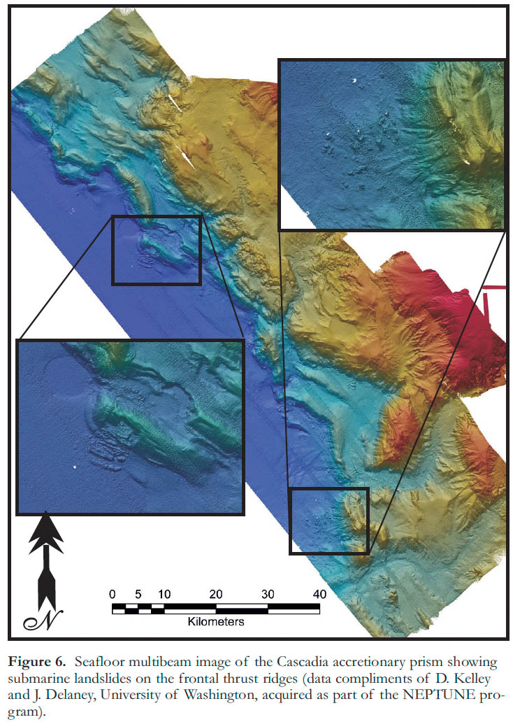
12 On Canada’s west coast, seismicity along the continental slope is common because of active convergent and transform margins (Hyndman 1995). Sediment mass transport processes are a common phenomenon along convergent margins because of frequent and strong seismicity combined with steep slope angles and potential for elevated pore-pressures (Tappin et al. 2001, 2007; Goldfinger et al. 2003). The complex geology of accretionary margins results in variable scenarios for landslide generation, and also makes identification of landslides difficult. Figure 6 shows the only known examples of landslides along the forethrust region of the Cascadia accretionary prism. Along the adjacent Oregon margin, however, Goldfinger et al. (2000) and McAdoo et al. (2004) recognized large landslide deposits and assessed their tsunami-generating potential. Völker et al. (2009) mapped a submarine landslide off the Chilean accretionary margin that is remarkably similar in morphology to the Canadian examples. A submarine landslide off Papua New Guinea in 1998 showed that subduction-related, landslide-generated tsunamis can be more hazardous than the subduction event itself (Tappin et al. 2007).
Figure 6. Seafloor multibeam image of the Cascadia accretionary prism showing submarine landslides on the frontal thrust ridges (data compliments of D. Kelley and J. Delaney, University of Washington, acquired as part of the NEPTUNE program).
Display large image of Figure 6
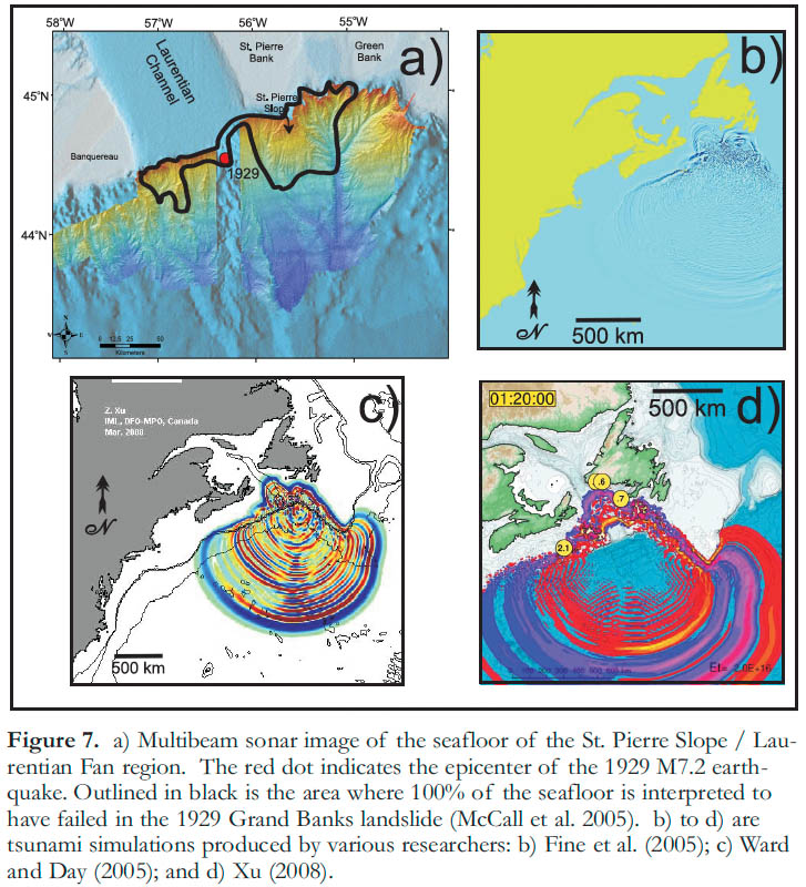
13 Canada’s eastern and northern continental margins are tectonically passive margins and seismicity is rare (Adams and Halchuk 2003). In the past, seismicity was probably more commonly related to deglacial isostatic rebound, or periods when possible ocean basin-scale tectonism was active (Weaver 2003). Earthquakes up to M7+, however, can be expected (Mazzotti and Adams 2005), and do occur, such as the 1929 M7.2 event off the southern tail of the Grand Banks (Bent 1995). Amongst geoscientists, the 1929 Grand Banks landslide is perhaps the most famous historic submarine landslide. It led to the first formal recognition of naturally occurring turbidity currents (Heezen et al. 1954; Piper et al. 1988), and revealed that seafloor displacements due to mass-failure can cause damaging tsunamis at great distances from their source (Ruffman and Tuttle 1995; Ruffman 1997, 2001; Fine et al. 2005). It also showed that undersea events can cause damage to engineering structures.
14 A significant portion of Canada’s Atlantic margin has been surveyed with modern seismic reflection technologies and to a lesser extent by multibeam sonar, permitting identification of submarine landslide deposits (Campbell et al. 2004). Mosher and Piper (2007a, b) recently studied the seafloor of the St. Pierre Slope, the area of the 1929 event, using multi-beam sonar surveys (Fig. 7). These data show numerous fresh escarpments ranging from 5 to 100 m in height, but no evidence of a single large headscarp or debris lobe. These results suggest that the landslide was relatively thin (5-100 m, averaging about 20 m) and dispersed over a relatively large area (~7200 km2), as suggested by earlier studies (Masson et al. 1985; Piper et al. 1988, 1992, 1999). McCall (2006) estimated the total volume of failed sediment in the area of St. Pierre Valley and St. Pierre Slope between the 500 and 2000 m isobaths to be about 93.5 km3, of which about half was evacuated and half remained.
Figure 7. a) Multibeam sonar image of the seafloor of the St. Pierre Slope / Laurentian Fan region. The red dot indicates the epicenter of the 1929 M7.2 earthquake. Outlined in black is the area where 100% of the seafloor is interpreted to have failed in the 1929 Grand Banks landslide (McCall et al. 2005). b) to d) are tsunami simulations produced by various researchers: b) Fine et al. (2005); c) Ward and Day (2005); and d) Xu (2008).
Display large image of Figure 7
15 The shoaling series of escarpments on St. Pierre Slope, consisting of rotated blocks and basal debris (McCall et al. 2005), suggests a retrogressive style of failure. The morphology of this sea-floor terrain is similar to that seen everywhere on the Scotian Slope, particularly on broad, flat inter-canyon regions (Mosher et al. 2004c; Fig. 6), suggesting that similar thin-skinned underwater landslides may be relatively common on the eastern Canadian continental margin.
16 The tsunami resulting from the 1929 Grand Banks submarine landslide impacted the south coast of the Burin Peninsula just over two hours after the slide. From observational evidence, the wave is estimated to have been 3 to 8 m high, and run-up heights were approximately 13 m (Ruffman 1997). Coastal infrastructure was destroyed, 12 undersea cables severed, and 28 people were killed. Because this event occurred in historically recent time and much is known of the earthquake (Bent 1995), landslide (Piper et al. 1988, 1999; McCall et al. 2005) and tsunami metrics (Ruffman 1997), this is a critical event for calibration of landslide and tsunami numerical simulations (Fine et al. 2005; Ward and Day 2005; Xu 2007, 2008; Fig. 7).
17 In seismic profile, submarine landslide deposits are often characterised by incoherent reflections with typically irregular surfaces and possible erosional bases. As data have become more widely available, it has been recognized that landslide deposits on passive margins are prevalent at both the sea-floor surface and subsurface (Mienert and Weaver 2003; Benetti 2006). Mosher et al. (2009b) described a Late Pliocene to Early Pleistocene landslide on the Scotian Slope that had a run-out distance >100 km and a total volume in excess of 862 km3. They numerically simulated a tsunami for this event and demonstrated that a 13 to 25 m-high wave would have struck the Halifax area in less than 80 minutes, assuming present-day water depths (Fig. 8). Similar-sized submarine landslide deposits have been recognized elsewhere along the Canadian Atlantic margin (Deptuck et al. 2007) and smaller deposits are abundant (Tripsanas and Piper 2008; Mosher and Campbell in press; Campbell and Mosher 2009; Giles et al. 2009).
Figure 8. Tsunami simulation for a large (862 km3) Plio/Pleistocene submarine landslide on the southwestern Scotian Slope, 85 minutes post-failure (from Mosher et al. 2009b).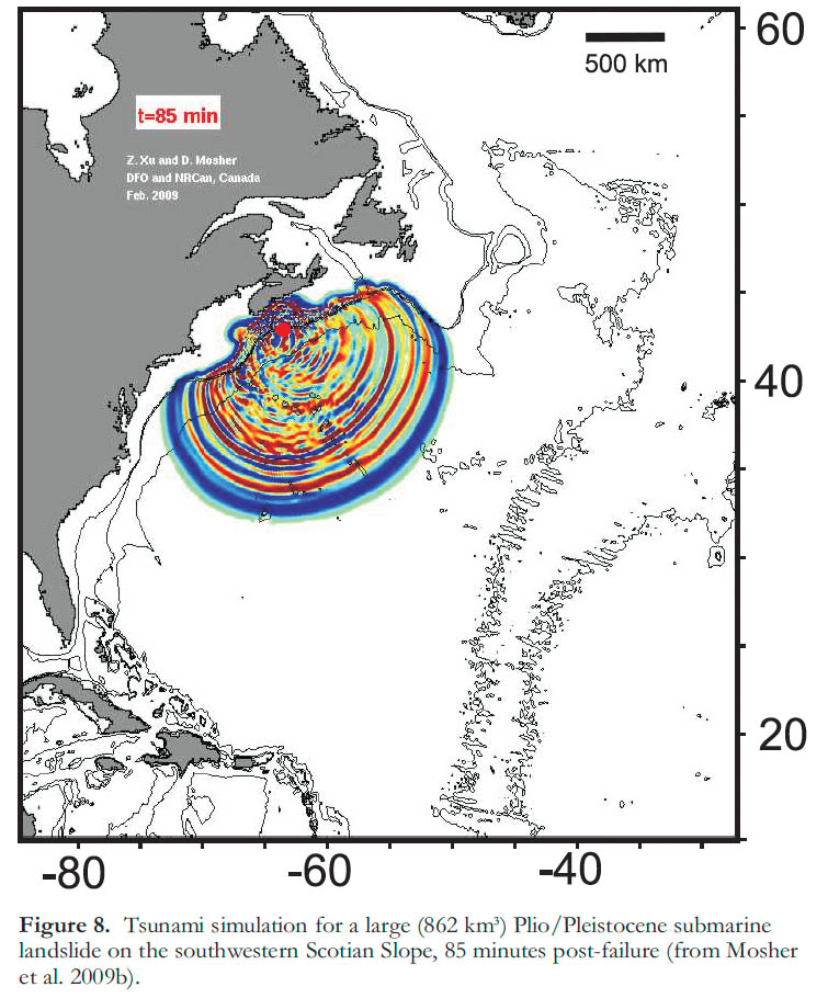
LANDSLIDE AND TSUNAMI HAZARD ASSESSMENT
18 The prevalence of submarine landslide deposits in coastal and continental margin settings in Canada underlines the potential for future submarine landslides and consequent tsunamis in these environments. It is believed that earthquake ground accelerations are a common initiating factor for many submarine landslides; hence, to some degree the potential for a landslide event is dependent upon the seismic hazard in the area. In the active tec-tonic setting of Canada’s west coast, earthquake potential is high. Although subduction megathrust events are rare on human time scales (hundreds of years), significant (M6+) earthquakes can occur anywhere within the forearc crustal setting (Hyndman et al. 2003). These events, particularly in concert with ground motion amplification, can initiate sediment liquefaction and failure on slopes with sufficient sediment mass. Particularly susceptible are areas with thick, rapidly deposited sediment accumulations, such as the Fraser and MacKenzie River deltas.
19 In eastern Canada, the seismic risk is low, although residual post-glacial strain is still of concern (Mazzotti et al. 2005; Mazzotti 2007) and may result in latent seismic events up to ~M7.0. Areas most susceptible are those with significant sediment mass resting on slopes, particularly those areas overlying formerly active tectonic elements where reactivation is a possibility (Mazzotti 2007). The coastal zone of the St. Lawrence River and estuary is, therefore, susceptible to submarine landsliding and tsunami-generation (Lamontagne 2009; Poncet et al. 2009). The eastern Canadian continental margin is also susceptible to landsliding, as demonstrated by the historic event of the 1929 Grand Banks earthquake, landslide and tsunami. Although the expected earthquake recurrence rate is relatively low in the latter region (Adams and Halchuk 2003), there are other contributing factors to seafloor instability, such as shallow gas, gas hydrates, subsurface salt mobility, paleo-tectonic structures and thick sediment accumulations in some regions, such as the Laurentian Fan. A study by Mosher et al. (2004c) along the Scotian Slope has shown a strong correlation of events with glacial advances and recessions, and few landslides in the post-glacial period (i.e. the last 10 000 years). Mosher et al. (2004c) suggest recurrence intervals of a thousand years for smaller events, and 10 000 to 100 000 years for larger submarine landslides.
20 When assessing the tsunami-generating capacity of a submarine landslide, there are many factors to consider (Ward and Day 2005). From a source function perspective, the volume, area, displacement, acceleration and water depth are critical. Most slides are complex, and may include a rotational component resulting in uplift in one area and down-drop in another; failure typically progresses from a slide to a debris flow and eventually a turbidity current (Locat and Lee 2002). Each of these elements affects tsunami generation differently, and in most cases it is difficult to predict these factors in advance of a failure.
21 After tsunami initiation, wave propagation is affected by seafloor bathymetry and coastal morphology and may therefore also be complex. This is particularly true in coastal settings, where wave reflection and refraction, along with resonance and edge wave effects can cause prolonged propagation and wave amplification. For example, Koh Phi Phi Island in Thailand was inundated from both seaward and landward directions in the 2004 Sumatran tsunami (Ioualalen et al. 2007). Its landward (northern) side was struck because waves refracted around the island from both directions, and constructive interference and amplification occurred as they met on the backside. Resonant effects causing wave amplification were also demonstrated in the 1964 tsunami that struck Port Alberni, BC (White 1966; Fine et al. 2008), whose long, narrow inlet is typical of the BC coastline. The 1992 Cape Mendocino earthquake, at the southern end of the Cascadia Subduction Zone, generated a tsunami in which the largest observed amplitude was associated with an edge wave that arrived almost three hours after initial onset of the tsunami (Gonzàles et al. 1995). Finally, run-up distances are governed not only by wave height and mass but also by the coastal (terrain) slope angle and subaerial elevation.
22 As shown in a number of the above examples, numerical simulations of tsunamis can approximate real waves, but rarely do they duplicate them. Additionally, these models are not functional as planning or assessment measures because they are source dependent, and as discussed, it is difficult to know the source function a priori, i.e. a future tsunami may not happen at a pre-specified location. To have a full preparedness against future tsunamis, a source-independent approach must be adopted. Xu (2007) developed such a methodology using the All-Source Green Function (ASGF), which is pre-calculated and can be reused for any tsunami source. The ASGF can be constructed for any point of interest, using the entire ocean domain as potential sources. The function manifests in matrix form, and upon convolving with an initial source vector, it instantaneously gives the time series for tsunami arrivals at a designated “point of interest” (Halifax, in the example shown in Figure 9). Instead of guessing a future epicentre to predict tsunami arrival, the focus is on the point of interest; the ASGF describes exactly how the water level at this point will respond to a unit forcing in any part of the model domain.
Figure 9. All Source Green Function (ASGF) model of a) tsunami travel time and b) gain (amplitude) at Halifax for all locations in the Atlantic (from Xu 2007); c) tsunami time and gain arrival plots at Halifax for three landslide source locations along the Atlantic margin: source 1, the 1929 Grand Banks landslide site; source 2, central Scotian Slope; and source 3, southwestern Scotian Slope (Northwest Channel) (from Xu 2008).
Display large image of Figure 9
23 The ASGF also employs new types of tsunami maps, the arrival-time map and the gain (amplitude) map (Fig. 9), without assuming a tsunami source and without assuming the tsunami path reversibility (Xu 2007). The time map (Fig. 9a) shows arrival time at Halifax for tsunamis that may originate anywhere in the North Atlantic Ocean. The corresponding gain map is the wave amplitude relative to one unit of sea surface displacement at a source region of 100 x 100 km2. Alternatively, the gain map may be referred to as the impact map. The arrival time map and the gain map complement each other, and, in combination with geologic assessments of regions with submarine landslide potential, provide important information for tsunami preparedness. Figure 9 shows wave arrivals at Halifax for tsunamis sourced from three areas of the eastern continental margin where landslides may potentially occur: 1) the area of the 1929 earthquake; 2) the central Scotian Slope, where there is thick sediment accumulation; and 3) Northeast Channel, a major ice corridor and glacial outwash depocentre during the last deglaciation. The arrival times are 2.15h, 1.17h and 1.60h, respectively. In the event of an off-shore earthquake, the ASGF can also be used in real time to determine tsunami arrival time, assuming a tsunami will be generated by the event.
CONCLUSIONS
24 With the longest coastline in the world and perhaps the largest continental margin, Canada has significant exposure to marine hazards, including the potential for submarine landslides and associated tsunamis. The lessons learned in Canada and internationally are that costs related to these phenomena, in terms of human life and economics, can be immense. Coastal landslides represent a significant threat because of their proximity to societal infrastructure and their high tsunami-generating potential. They occur without warning and with little time lag between failure and subsequent tsunami impact. Regions prone to frequent earthquake activity, such as southwestern BC and the St. Lawrence River estuary, are particularly susceptible, although there are a variety of other contributing factors.
25 Continental margin landslides are common in the geologic record but rare on human timescales. Areas of high earthquake potential, such as the Cascadia subduction margin, are not necessarily the most vulnerable to threats of submarine landslides and consequent tsunamis. Thick deposits of unconsolidated sediment that have the potential to fail down-slope probably represent a greater contributing factor. The passive continental margin of the Atlantic, on which large volumes of glacial outwash sediment have accumulated, may be susceptible to mass failure, particularly given latent earthquake potential related to isostatic rebound. The 1929 Grand Banks landslide and consequent tsunami is a classic example of this type. In these instances, tsunami impact can be hundreds of km away from the source event. However, given the speed that tsunamis travel, warning times are limited to within a couple of hours for most vulnerable locations.
26 In most instances of submarine landsliding and tsunami generation, prevention is not possible and planning is necessary. Identification of high potential submarine landslide regions, combined with an understanding of landslide and tsunami processes and sophisticated tsunami propagation and inundation models, are required to identify areas at high risk of impact.
ACKNOWLEDGEMENTS
A review article such as this is based on the work of many colleagues and the author would like to thank these colleagues for their research efforts in this field and their willingness to share results through vital discussion and through their publications. This article was instigated by a request to provide a keynote lecture at the IVth Canadian Conference on Geohazards in 2008 and the author thanks J. Locat for that opportunity. The author also thanks GSC-Pacific, S. Ward, Z. Xu, A. Rabinovich, I. Fine, R. Poncet and R. Bennet for permitting the use of their tsunami simulations and multibeam imagery, and the reviewers and editors (Drs. M. Duchesne, D.C. Campbell, R. Thomson and R. Wilson) for improving this manuscript immensely. Natural Resources Canada, Earth Science Sector, Geological Survey of Canada Contribution No. 20090078.Author: Mosher, D.C. © Her Majesty the Queen in right of Canada 2009
REFERENCES
Adams, J. and Atkinson, G., 2003, Development of seismic hazard maps for the proposed 2005 edition of the National Building Code of Canada: Canadian Journal of Civil Engineering, v. 30, p. 255-271.
Adams J., and Halchuk S., 2003, Fourth generation seismic hazard maps of Canada: Values for over 650 Canadian localities intended for the 2005 National Building Code of Canada: Geological Survey of Canada Open File 4459, 155 p.
Atkins, R.J., and Luternauer, J.L., 1991, Reevaluation of slope failure volume estimates involving 3D computer graphics for the Fraser River delta front, British Columbia: Geological Survey of Canada, Current Research Part E, Paper 91-1E, p. 59-65.
Benetti, S., 2006, Late Quaternary sedimentary processes along the western North Atlantic margin: Unpublished Ph.D. thesis, National Oceanography Centre, Southampton, UK, 188 p.
Bennett, R., Rochon, A., Schell, T., Bartlett, J., Blasco, S., Hughes-Clarke, J., Scott, D., MacDonald, A., and Rainey, W., 2004, Cruise report, Amundsen 2004-804: Beaufort Sea / Amundsen Gulf / Northwest Passage, June 23 -August 27, 2004: Geological Survey of Canada, Open File 5798, 111 p.
Bent, A.L., 1995, A complex double-couple source mechanism for the M7.2 1929 Grand Banks earthquake: Bulletin of the Seismological Society of America, v. 85, p. 1003-1020.
Bornhold, B.D., Thomson, R.E., Rabinovich, A.B., Kulikov, E.A. and Fine, I.V., 2001, Risk of landslide-generated tsunamis for the coast of British Columbia and Alaska, in Mahmoud, M., van Everdingen, R., and Carss, J., eds., An Earth Odyssey, 54th Canadian Geotechnical Society Conference Proceedings: Bitech Publishers Ltd., Richmond, BC, p. 1450-1454.
Bornhold, B.D., Harper, J.R., McLaren, D. and Thomson, R.E., 2007, Destruction of the pre-contact First Nations village of Kwalate by a rock avalanche-generated tsunami: Atmosphere-Ocean, v. 45, p. 123-128.
Campbell, D.C., and Mosher, D.C., 2009, Middle Cenozoic unconformities and slope failure on the western Scotian margin, in Mosher, D.C., Shipp, C., Moscardelli, L., Baxter, C, Chaytor, J., Lee, H., and Urgeles, R, eds., Submarine Mass Movements and their Consequences, Fourth International Symposium, Advances in Natural and Technological Hazards Research: Springer, The Netherlands, p. 645-656.
Campbell, D.C., Shimeld, J.W., Mosher, D.C., and Piper, D.J.W., 2004, Relationships between sediment mass-failure modes and magnitudes in the evolution of the Scotian Slope, offshore Nova Scotia: Offshore Technology Conference, Paper 16743, May, 2004, Houston, TX.
Cassidy, J.F., and Rogers, G.C., 2004, Variation in ground shaking on the Fraser River delta (Greater Vancouver, Canada) from analysis of moderate earthquakes: 13th World Conference on Earthquake Engineering, Vancouver, BC, Canada, August 1-6, 2004, Paper No. 1010, 7 p.
Cauchon-Voyer, G., Locat, J., and St.-Onge, G., 2007, Submarine mass movements in the Betsiamites area, Lower St. Lawrence Estuary, Québec, Canada, in Lykousis, V., Sakellariou, D., and Locat, J., eds., 2007, Submarine Mass Movements and their Consequences: Advances in Natural and Technological Hazards Research, v. 27, Springer, The Netherlands, p. 233-241.
Christian, H.A., Mosher, D.C., Mulder, T., Barrie, J.V., and Courtney, R.C., 1997, Geomorphology and potential slope instability on the Fraser River delta foreslope, Vancouver, British Columbia: Canadian Geotechnical Journal, v. 34, p. 432-446.
Christian, H.A., Mosher, D.C., Barrie, J.V., Hunter, J.A., and Luternauer, J.L., 1998, Seabed instability on the Fraser River delta, in Clague, J.J., Luternauer, J.L. and Mosher, D.C., eds., Geology and Natural Hazards of the Fraser River Delta, British Columbia: Geological Survey of Canada, Bulletin 525, p. 217-230.
Deptuck, M.E., Mosher, D.C., Campbell, D.C., Hughes-Clarke, J.E., and Nose-worthy, D., 2007, Along slope variations in mass failures and relationships to major Plio-Pleistocene morphological elements, SW Labrador Sea, in Lykousis, V., Sakellariou, D., and Locat, J., eds., 2007, Submarine Mass Movements and their Consequences: Advances in Natural and Technological Hazards Research, v. 27, Springer, The Netherlands, p. 37-46.
Evans, S.G., 2001, Landslides, In Brooks, G.R., ed., A Synthesis of Geological Hazards in Canada: Geological Survey of Canada, Bulletin 548, p. 43-79.
Fine, I.V., Rabinovich, A.B., Bornhold, B.D., Thomson, R.E., and Kulikov, E.A., 2005, The Grand Banks landslide-generated tsunami of November 18, 1929: Preliminary analysis and numerical modeling: Marine Geology, v. 215, p. 45-57.
Fine, I.V., Cherniawsky, J.Y., Rabinovich, A.B. and Stephenson, F., 2008, Numerical modeling and observations of tsunami waves in Alberni Inlet and Barkley Sound, British Columbia: Pure and Applied Geophysics, v.165, p. 2019-2044.
Giles, M.K., Mosher, D.C., Piper, D.J.W., and Wach, G.D., 2009, Mass transport processes on the southwestern Newfoundland Slope and associated structural and stratigraphic factors, in Mosher, D.C., Shipp, C., Moscardelli, L., Baxter, C, Chaytor, J., Lee, H., and Urgeles, R., eds., Submarine Mass-Movements and their Consequences, 4th International Symposium, Advances in Natural and Technological Hazards Research: Springer, The Netherlands, p. 657-666.
Goldfinger, C., Kulm, L.D., McNeill, L.C., and Watts, P., 2000, Super-scale failure of the southern Oregon Cascadia margin: Pure and Applied Geophysics, v. 157, p. 1189-1226.
Goldfinger, C., Nelson, C.H., and Johnson, J., 2003, Deep-water turbidites as Holocene earthquake proxies: The Cascadia subduction zone and northern San Andreas fault systems: Annali Geofisica, v. 46, p. 1169-1194.
Gonzàlez, F.I., Satake, K., Boss, E.F. and Mofjeld, H.O., 1995, Edge wave and non-trapped modes of the 25 April 1992 Cape Mendocino tsunami: Pure and Applied Geophysics, v. 144, p. 409-426.
Heezen, B.C., Ericson, D.B., and Ewing, M., 1954, Further evidence for a turbidity current following the 1929 Grand Banks earthquake: Deep Sea Research, v. 1, p. 193-202.
Hill, P.R., Moran, K.M., and Blasco, S.M., 1982, Creep deformation of slope sediments in the Canadian Beaufort Sea: Geo-Marine Letters, v. 2, p. 163-170.
Hsu, S.K., Tsai, C.-H., Ku, C.-Y. and Sibuet, J.-C., 2009, Flow of turbidity currents as evidenced by failure of submarine telecommunication cables, in Chiocci, F.L., Ridenti, D., Casalbore, D., and Bosman, A., eds., International Conference on Seafloor Mapping for Geohazard Assessment, Extended Abstracts, Rendiconti online, Società Geologica Italiana, v. 7, p. 167-171.
Hyndman, R.D., 1995, Giant earthquakes of the Pacific Northwest: Scientific American, v. 273, p. 68-75.
Hyndman, R.D., Mazzotti, S., Weichert, D., and Rogers, G.C., 2003, Frequency of large crustal earthquakes in Puget Sound – southern Georgia Strait predicted from geodetic and geological deformation rates: Journal of Geophysical Research, v. 108, p.12-1 to 12-12.
Hyndman, R.D., Cassidy, J.F., Adams, J., Rogers, G.C., and Mazzotti, S., 2005, Earthquakes and seismic hazard in the Yukon-Beaufort-Mackenzie: Canadian Society of Exploration Geophysicists Explorer, May, 2005, p. 32-66.
Ioualalen, M., Asavanant, J., Kaewbanjak, N., Grilli,S., Kirby, T.J.T., and Watts P., 2007, Modeling the 26 December 2004 Indian Ocean tsunami: Case study of impact in Thailand: Journal of Geophysical Research, v. 112, C07024, doi:10.1029/2006JC003850, 21 p.
Lamontagne, M., 2009, Possible earthquake triggers of submarine landslides in the estuary of the St. Lawrence River: Insights from the earthquake catalog: Geological Survey of Canada Open File Report No. 6007, 1 CDRom.
LaPierre, S., 2007, Taiwan earthquake fiber cuts: A service provider view: North America Network Operators Group Forum 39, Toronto, Ontario, Canada, February 4-7, 2007.
Levesque, C.L., Locat, J., and Leroueil, S., 2006, Dating submarine mass movements triggered by earthquakes in the Upper Saguenay Fjord, Québec, Canada: Norwegian Journal of Geology, v. 86, p. 231-242.
Locat, J., and Lee, H.J., 2002, Submarine landslides: Advances and challenges: Canadian Geotechnical Journal, v. 39, p. 193-212.
Locat, J., and Meinert, J., eds., 2003, Submarine Mass Movements and Their Consequences: 1st International Symposium, Advances in Natural and Technological Hazards Research: Kluwer Academic Publishers (Springer), The Netherlands, 540 p.
Lykousis, V., Sakellariou, D., and Locat, J., eds., 2007, Submarine Mass Movements and their Consequences: Advances in Natural and Technological Hazards Research, v. 27, Springer, The Netherlands, 424 p.
McAdoo, B.G., Capone, M.K., and Minder, J., 2004, Seafloor geomorphology of convergent margins: Implications for Cascadia seismic hazard: Tectonics, v. 23, doi: 10.1029/ 2003TC001580, 15 p.
Masson, D.G., Gardner, J.V., Parson, L.M., and Field, M.E., 1985, Morphology of Upper Laurentian Fan using GLORIA long-range side-scan sonar: American Association of Petroleum Geologists Bulletin, v. 69, p. 950-959.
Mazzotti, S., 2007, Geodynamic models for earthquake studies in intraplate North America, in Stein, S., and Mazzotti, S., eds., Continental Intraplate Earthquakes: Science, Hazard, and Policy Issues: Geological Society of America Special Paper 425, doi: 10.1130/2007.2425(02), p. 17–33.
Mazzotti, S., and Adams, J., 2005, Rates and uncertainties on seismic moment and deformation in eastern Canada: Journal of Geophysical Research, v. 110, B09301, doi:10.1029/2004JB003510, 16 p.
Mazzotti, S., James, T.S., Henton, J., and Adams, J., 2005, GPS crustal strain, postglacial rebound, and seismic hazard in eastern North America: The Saint Lawrence valley example: Journal of Geophysical Research, v. 110, B11301, doi: 10.1029/2004JB003590, 16 p.
McCall, C., 2006, Character and distribution of the 1929 landslides: Unpublished M.Sc. thesis (applied), St. Mary’s University, Halifax, NS, Canada, 145 p.
McCall, C., Morrison, M.L., and Piper, D.J.W., 2005, Geological data from the St. Pierre Slope around the epicentre of the 1929 Grand Banks earthquake: Geological Survey of Canada, Open File 4879, 15 p. (+CD-Rom).
McKenna, G.T., and Luternauer, J.L., 1987, First documented large failure at the Fraser River delta front, British Columbia: Geological Survey of Canada, Current Research, Part A, Paper 87-1A, p. 919-924.
Mienert, J. and Weaver, P., eds., 2003, European Margin Sediment Dynamics: Sidescan Sonar and Seismic Images: Springer-Verlag, New York, 305 p.
Miller, D.J., 1960, Giant waves in Lituya Bay, Alaska: U.S. Geological Survey Professional Paper 354-C, U.S. Government Printing Office, Washington, p. 51-86.
Mosher, D.C., and Piper, D.J.W., 2007a, Multibeam seafloor imagery of the Laurentian Fan and the 1929 Grand Banks landslide area: Geological Survey of Canada Open File 5638,
Mosher, D.C., and Piper, D.J.W., 2007b, Analysis of multibeam seafloor imagery of the Laurentian Fan and the 1929 Grand Banks landslide area, in Lykousis, V., Sakellariou, D., and Locat, J., eds., Submarine Mass Movements and Their Consequences: Advances in Natural and Technological Hazards Research, v. 27, Springer, The Netherlands, p. 77-88.
Mosher, D.C., and Campbell, D.C., in press, The Barrington submarine mass-transport deposit, western Scotian Slope, in Shipp, R.C., Weimer, P., and Posamen-tier, H.W., eds., Mass-transport Deposits in Deepwater Settings: Society of Economic Paleontologists and Mineralogists, Special Publication 95.
Mosher, D.C., Moran, K.M., and Hiscott, R.N., 1994, Late Quaternary sediment, sediment mass-flow processes and slope instability on the Scotian Slope: Sedimentology, v. 41, p. 1039-1061.
Mosher, D.C., Cassidy, J.F., Lowe, C., Mi., Y., Hyndman, R.D., Rogers, G.C., and Fisher, M., 2000, Neotectonics in the Strait of Georgia: First tentative correlation of seismicity with shallow geological structure in southwestern British Columbia, in Current Research: Geological Survey of Canada, Paper 2000-A22, 9 p.
Mosher, D.C., Christian, D.C., Hunter, J.A., and Luternauer, J.L., 2004a, Onshore and offshore geohazards of the Fraser River delta, in Groulx, B.J., Mosher, D.C., Luternauer, J.L., and Bilderback, D.B., eds., Fraser River Delta: Issues of an Urban Estuary: Geological Survey of Canada, Bulletin 567, p. 67-81.
Mosher, D.C., Monahan, P.A., Barrie, J.V., and Courtney, R.C., 2004b, Coastal submarine failures in the Strait of Georgia, British Columbia: Landslides of the 1946 Vancouver Island earthquake: Journal of Coastal Research, v. 20, p. 277-291.
Mosher, D.C., Piper, D.J.W., Campbell, D.C., and Jenner, K.A., 2004c, Near surface geology and sediment failure geohazards of the central Scotian Slope: American Association of Petroleum Geologists Bulletin, v. 88, p. 703-723.
Mosher, D.C., Shipp, C., Moscardelli, L., Baxter, C, Chaytor, J., Lee, H., and Urgeles, R., eds., 2009a, Submarine Mass Movements and their Consequences, Fourth International Symposium, Advances in Natural and Technological Hazards Research: Springer, The Netherlands, 792 p.
Mosher, D.C., Xu, Z., and Shimeld, J., 2009b, The Pliocene Shelburne mass-movement and consequent tsunami, western Scotian Slope, in Mosher, D.C., Shipp, C., Moscardelli, L., Baxter, C, Chaytor, J., Lee, H., and Urge-les, R., eds., Submarine Mass Movements and their Consequences, Fourth International Symposium, Advances in Natural and Technological Hazards Research: Springer, The Netherlands, p. 765-776.
Paull, C.K., Ussler, W., Dallimore, D.R., Blasco, D.M., Lorenson, T.D., Melling, H., Medioli, B.E., Nixon, F.M., and McLaughlin, F.A., 2007, Origin of pingo-like features on the Beaufort Sea shelf and their possible relationship to decomposing methane gas hydrates: Geophyical Research Letters, v. 34, L01603, doi:10.1029/2006GL027977, 5 p.
Piper, D.J.W., Shor, A.N., and Hughes Clarke, J.E., 1988, The 1929 Grand Banks earthquake, slump, and turbidity current: Geological Society of America Special Paper No. 229, p. 77-92.
Piper, D.J.W., Cochonat, P., Ollier, G., Le Drezen, E., Morrison, M., and Baltzer, A., 1992, Evolution progressive d’un glissement rotationnel en un courant de turbidite: cas du seisme de 1929 des Grands Bancs [Terre - Neuve]: Comptes rendus de l’academie des sciences, Serie II, Mechanique, Physique, Chimie, sciences de l’univers, sciences de la terre, v. 314, p. 1057-1064.
Piper, D.J.W., Cochonat, P., and Morrison, M.L., 1999, The sequence of events around the epicentre of the 1929 Grand Banks earthquake: Initiation of debris flows and turbidity current inferred from sidescan sonar: Sedimentology, v. 46, p. 79-97.
Prior, D.B., Bornhold, B.D., Coleman, J.M., and Bryant, W.R., 1982, Morphology of a submarine slide, Kitimat Arm, British Columbia: Geology, v. 10, p. 588–592.
Poncet, R., Campbell, D.C., Dias, F., Locat, J., and Mosher, D.C., 2009, A study of the tsunami effects of two landslides in the St. Lawrence estuary, in Mosher, D.C., Shipp, C., Moscardelli, L., Baxter, C, Chaytor, J., Lee, H., Urgeles, R., eds., Submarine Mass Movements and their Consequences, Fourth International Symposium, Advances in Natural and Technological Hazards Research: Springer, The Netherlands, p. 755-764.
Rabinovich, A.B., Thomson, R.E., Born-hold, B.D., Fine, I.V., and Kulikov, E.A., 2003, Numerical modelling of tsunamis generated by hypothetical landslides in the Strait of Georgia, British Columbia: Pure and Applied Geophysics, v. 160, p. 1273-1313.
Rogers, G.C., 1980, A documentation of soil failure during the British Columbia earthquake of 23 June, 1946: Canadian Geotechnical Journal, v. 17, p. 122-127.
Ruffman, A., 1997, Tsunami runup mapping as an emergency preparedness planning tool: The 1929 tsunami in St. Lawrence, Newfoundland: Geomarine Associates, Contract Report for Emergency Preparedness Canada (EPC), Ottawa, Ontario, v. 1, 107 p.
Ruffman, A., 2001, Forum: Potential for large-scale submarine slope failure and tsunami generation along the U.S. mid-Atlantic Coast [Comment]: Geology, v. 29, p. 967.
Ruffman, A., and Tuttle, M.P., 1995, The search for the onshore signature of the November 18, 1929, tsunami from the “Grand Banks” Earthquake: Canada’s most tragic earthquake (abstract): Tsunami Deposits, Geologic Warnings of Future Inundation meeting, University of Washington, Program with Abstracts, p. 7-8.
Tappin, D.R., Watts, P., McMurtry, G.M., Lafoy, Y., and Matsumoto, T., 2001, The Sissano, Papua New Guinea tsunami of July 1998: Offshore evidence on the source mechanism: Marine Geology, v. 175, p. 1-23.
Tappin, D.R., McNeill, L.C., Henstock, T., and Mosher, D.C., 2007, Mass wasting processes – offshore Sumatra, in Lykousis, V., Sakellariou, D., and Locat, J., eds., Submarine Mass Movements and Their Consequences: Advances in Natural and Technological Hazards Research, v. 27, Springer, The Netherlands, p. 327-336.
Terzaghi, K., 1956, Varieties of submarine slope failure (abstract): Proceedings of the 8th Texas Conference on Soil Machnics and Foundation Engineering, University of Texas, Austin, Bureau of Engineering Research, Special Publication No. 29, 41 p.
Tripsanas, E.K., and Piper, D.J.W., 2008, Glaciogenic debris-flow deposits of orphan basin, offshore eastern Canada: Sedimentological and rheological properties, origin, and relationship to meltwater discharge: Journal of Sedimentary Research, v. 78, p. 724-744.
Urgeles, R., Locat, J., Lee, H., Martin, F., and Konrad, J.-M., 2001, The Saguenay Fjord: Integrating marine geotechnical and geophysical data for spatial slope stability hazard analysis: An Earth Odyssey, 54th Canadian Geotechnical Society Conference Proceedings, Bitech Publishers Ltd., Richmond, B.C. p. 768-775.
Völker, D., Weinrebe, W., Behrmann, J.H., Bialas, J., and Klaeschen, D., 2009, Prominent submarine mass wasting structures at the southern central Chilean continental margin: The Roca Slide, in Chiocci, F.L., Ridenti, D., Casalbore, D., and Bosman, A., eds., International Conference on Seafloor Mapping for Geohazard Assessment, Extended Abstracts, Rendiconti online, Società Geologica Italiana, v. 7, p. 209-210.
Ward, S., and Day, S., 2005, Tsunami thoughts: Canadian Society of Exploration Geophysicists Explorer, December, p. 38-44.
Weaver, P.P.E., 2003, Northwest African continental margin: History of sediment accumulation, landslide deposits, and hiatuses as revealed by drilling the Madeira Abyssal Plain: Paleoceanography, v. 18, p. 1009, doi:10.1029/2002PA000758.
White, W.R.H., 1966, The Alaska earthquake...its effects in Canada: Canadian Geographical Journal, v. 72, p. 210-219.
Xu, Z., 2007, The all-source Green’s function and its applications to tsunami problems: Science of Tsunami Hazards, v. 26, p. 59-69.
Xu, Z., 2008, Modeling report for tsunami risk analysis due to submarine landslides on the Canadian east coast margin: Unpublished Report, Geological Survey of Canada (Atlantic), March, 2008, 6 p.