Series
Geoheritage 2.
Examples of Geoeducation, Geoconservation and Geo-rescue Projects in Ontario
J. Allan DonaldsonAdjunct Research Professor, Department of Earth Sciences, Carleton University, Ottawa, ON, Canada, K1S 5B6
donaldson6427@rogers.com
SUMMARY
Three case studies presented here outline the progress of projects recently initiated to improve public appreciation of the diversity, complexity and significance of Earth history, with an emphasis on the importance of such knowledge to humanity. Work on two of these projects has highlighted the paucity of legal protection for significant geological records as well as the frequent loss of basic geoscience data during construction-related landscape modification. These three case studies in promoting geoheritage awareness and geoconservation reinforce the need for the Canadian geoscience community to seek improved legal instruments for the protection of sites of geological and geomorphological importance, and to seek improved procedures for the documentation of information that too commonly is irretrievably lost during major construction projects.SOMMAIRE
Les trois études de cas présentées cidessous, permettent d’illustrer les progrès de projets récents visant à améliorer l’appréciation du public des notions de diversité, de complexité et des conséquences de l’histoire de la Terre, en insistant sur l’importance de ce savoir pour l’humanité. Le travail réalisé dans deux de ces projets a fait ressortir le manque de protection légale des archives géologiques d’importance ainsi que la perte fréquente de données géoscientifiques de base lors de travaux de construction altérant le paysage. En faisant la promotion de la sensibilisation à l’héritage géoscientifique et à sa conservation, ces trois projets renfor-cent la nécessité faite à la communauté géoscientifique canadienne de rechercher de meilleurs instruments légaux de protection des sites géologiques et géomorphologiques d’importance, et de rechercher de meilleurs procédures de documentation de l’information, laquelle est trop sou-vent irrémédiablement perdue à l’occasion de grands projets de construction.INTRODUCTION
1 Many European countries, Australia and China have developed extensive programs for geoheritage education, and, in general, are well ahead of Canada in recognizing and celebrating their geodiversity (Gray 2004), but groups concerned with geoscience education, such as the Canadian Geo-science Education Network (CGEN), are working to diminish the gap, with numerous projects now underway (Nowlan 2007). The Ottawa–Gatineau Geoheritage Project, initiated in 2002 and adopted as a new initiative by CGEN in 2003 [http://cgen.bio.ns.ca/cgennoteaug03.pdf], has been active in this regard through the provision of public talks, poster displays and field excursions (Donaldson 2003, 2005, 2006; Donaldson and Aylsworth 2004). In response to local interest, a complementary project was started in 2003 in Almonte Ward of Mississippi Mills, 55 km west of Ottawa. The Almonte Geoheritage Project follows the success of similar earlier projects in Waterloo (Peter Russell Rock Garden, University of Waterloo [http://www.earth.uwaterloo.ca/services/rockgarden]), in Regina (GEOrock Garden), in Haileybury at the Haileybury School of Mines [www.rockwalkpark.com], and in St. John’s (The Johnson GEO CENTRE and associated GEOPark [http://www.geocentre.ca/]). The rock display now being assembled in Almonte will be given the name ‘Metcalfe Geoheritage Park’ when officially opened in May 2010, making it the first municipal rock display to include ‘Geo-heritage’ in the official name of the display site. This display is being assembled entirely through volunteer contributions of rock specimens and transport.
2 Geoconservation presently receives little or no consideration in Canada during construction projects and the creation/expansion of roads. Where rock outcrops or unconsolidated deposits stand in the way of proposed construction, both rock and overburden almost invariably are regarded as obstacles to be removed, with little or no consideration of the possibility that these landscape elements contain unique, distinctive or representative records of our biotic and/or abiotic past. Except for Canada’s National and Provincial Parks and our World Heritage Sites, legislative protection is for the most part nonexistent. Although some provinces do offer limited recognition and protection, in practice most relevant laws are either not enforced or lack substantial clout to be effective. Québec offers the most advanced provincial geoheritage protection, and the three Territories provide legislative protection above the provincial level. In Ontario, designation as an Area of Natural Scientific Interest provides nominal protection against destruction, but some such sites have already been degraded or destroyed. When a new feature of potential significance is uncovered as a result of commercial excavation or road building anywhere in Canada, only rarely are formal procedures put in place to document the information revealed as construction proceeds, let alone afford protection. Geoconservation receives much greater attention in other countries (see the mandate of the GeoConservation Commission in the UK [www.geoconservation.com]).
3 The three case studies presented here are;
- Metcalfe Geoheritage Park
- Biofilm Structures in the Cambro-Ordovician Napean Formation
- Megastromatolites in Almonte
CASE STUDIES
Metcalfe Geoheritage Park
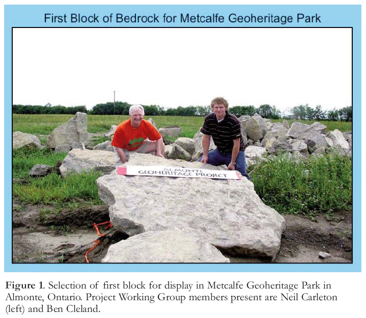
4 In June 2008, members of Mississippi Mills Council (MMC) in Eastern Ontario, unanimously endorsed a proposal to create within Metcalfe Park, an existing park in Almonte (a Ward of about 4400 inhabitants within Mississippi Mills, 55 km west of Ottawa), a display of large blocks and boulders representative of local geodiversity. They further approved the renaming of this park ‘Metcalfe Geoheritage Park’ with an official opening ceremony scheduled for May 2010. In 2003, as an initiative of the Almonte Geoheritage Project (in collaboration with the Ottawa–Gatineau Geoheritage Project), the creation of a geological display in Metcalfe Park was first proposed to MMC. Neil Carleton of the Almonte Geoheritage Working Group contacted relatives of Dr. Metcalfe, a prominent early resident of Almonte, and received their endorsement for geoheritage park designation. Plans evolved during subsequent meetings with members of MMC, and support was obtained from other organizations, including the Mississippi Mills Chamber of Commerce (MMCC) and the Mississippi Valley Field Naturalists (MVFN). Enthusiastic endorsement by all Council members, MMCC, MVFN and many relatives of Dr. Metcalfe (after whom the park was named; he was not only a renowned medical doctor, but also founded the local hydro facility within Almonte), have served to ensure successful development of an outdoor attraction that will provide an ideal setting for educating both local citizens and visitors about Canada’s geoheritage. Several self-guided field excursions have been designed to amplify what can be learned from the Metcalfe Geoheritage Park rock display, and a brochure containing this information will be available at the Almonte Visitors Centre, along with another brochure that will provide information about the rocks on display in Metcalfe Geoheritage Park.
Figure 1. Selection of first block for display in Metcalfe Geoheritage Park in Almonte, Ontario. Project Working Group members present are Neil Carleton (left) and Ben Cleland.
Display large image of Figure 1
5 Plans have been drawn up to accommodate 30 large specimens selected to display rock types, textures, structures and fossils. Nine specimens are now in place; 15 more have been selected and await transport and placement (Fig. 1). A recent appeal for additional specimens elicited numerous offers of donations from farms and rocky woodlots of MVFN members. Local construction companies have offered free removal, transport and placement of the selected contributions. The Metcalfe Geoheritage Park Project has gained substantial publicity through the Almonte Gazette and other local publications, greatly accelerating an awakening of interest in geoheritage. Don Wiles, a resident of Almonte and a Carleton University Professor Emeritus (Chemistry) has initiated the Learning in Almonte Series, a new program of educational lectures in collaboration with Carleton University. One of the first of the lecture series comprised six two-hour sessions on geoheritage, plus three local excursions to explore local geoheritage. Almonte has a fascinating history, and boasts numerous beautiful stone buildings. It has been satisfying to see how an extension of history from centuries to eons has come so readily to Almonte inhabitants.
Stromatolites and Biofilm Structures on Highway 417
6 Outcrops of Cambro-Ordovician Nepean Formation are exposed along both sides and within the median strip of the Queensway (Highway 417) in the Kanata suburb of Ottawa. Reports of soft-sediment deformation in outcrops of these strata immediately east of Terry Fox Drive led to Province of Ontario designation as an Area of Natural Scientific Interest (ANSI) in 1970. Such designation provides one of the few protective measures available for geologically significant sites outside Provincial Parks in Ontario. Re-examination in 2000 of these outcrops (Hilowle et al. 2000) resulted in recognition of the first-reported occurrences in Canada of quartz arenite containing stromatolites and biofilm structures (Fig. 2), thus greatly enhancing the ANSI significance of these outcrops. Subsequent research has confirmed the significance of this occurrence of siliciclastic stromatolites (Donaldson and Hilowle 2002, Donaldson et al. 2002, Donaldson et al. 2005a, b).
7 As a consequence of work commenced during the summer of 2008 to add lanes to the Queensway, all outcrops within the median at the Terry Fox ANSI site will be destroyed to provide space for two new lanes. On becoming aware of this planned highway widening the author, on behalf of Friends of Canadian Geoheritage (an organization sponsored by Canadian Geoscience Education Network), contacted key officials of the Ontario Ministry of Transport, Ontario Parks and Ontario Ministry of Environment. In a meeting with these officials in 2003, a ‘geosalvage operation’ was deemed feasible, subject to expression of interest from museums, universities and other organizations in securing blocks for public display. Representatives of Waterloo University, Carleton University, University of Ottawa, St. Lawrence University, Canadian Museum of Civilization, and the Town of Mississippi Mills all indicated interest in receiving one large specimen each from this site. With interest thus established, approval was granted for removal of up to 10 large blocks by jackhammer and hand-operated pry bars, rather than by blasting the rock. Recovery of these specimens will provide display material to illustrate structures documenting the role of cyanobacterial biofilm sheets in binding sand layers to create roll-up and desiccation structures in siliciclastic sand within an Ordovician intertidal environment. Had recent research not established the rarity of such distinctive structures, and Ontario Parks and Environment officials not been alerted to the pending road work, the outcrops containing these structures within the median of Highway 417 would have been completely destroyed, despite their ANSI designation.
Figure 2. Biofilm structures in quartz arenite of the Nepean Formation showing a bedding-parallel view of crumpled sheets of quartz sand. These layers are inferred to have been bound by cyanobacterial mats between the sand layers, now degraded to carbonaceous wisps. The site on Highway 417 at Terry Fox Drive in Ottawa is a designated Ontario Area of Natural Scientific Interest.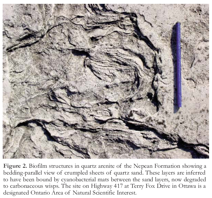
Megastromatolites in Almonte
8 With a heightened awareness of geo-heritage values stimulated by his work on the Metcalfe Geoheritage Park Project, Neil Carleton (Geography teacher, R. Tait McKenzie Public School in Almonte) immediately recognized the significance of a bedrock surface uncovered, in September 2008, within a block of his residence. The exposure was created during the start of development of a site for erection of a cluster of townhouses. Removal of a one-to-two-metre cover of Leda clay had revealed a unit of dolostone in the Paleozoic Oxford Formation replete with laterally linked domal stromatolites, some up to 4 m in diameter, with synoptic reliefs up to 60 cm (Fig. 3). Realizing that this exposure may present the best display of distinctive megastromatolites within an urban area anywhere in Canada, the developers were contacted to see if they would be amenable to preserving at least a small segment of this remarkable but potentially ephemeral exposure. It has the distinction of being the uppermost unit in the Oxford Formation, with relict patches of the overlying Rock-liffe sandstone preserved in several places at the top of the presently exposed area. Because there is no legislative recourse to obtain protection of newly uncovered geoheritage sites such as this one, preservation of a part of it hinges on the good will of the developers. Fortunately, the site developers are amenable to the possibility of preserving a small area containing several of the largest stromatolites. Depending on what accommodations can be provided to the developers (e.g. possible tax reduction and/or financial compensation for withdrawal of several townhouse lots from the planned development), there is reason to hope that a representative segment may be saved. Organizations that may offer assistance have been contacted (MMC, MVFN and Nature Conservancy of Canada); in the meantime, the ongoing operation continues to degrade the stromatolitic unit by mechanical fracturing and excavation.
Figure 3. Overview of giant domal stromatolites in dolostone of the Oxford Formation; Ann Street Townhouse Development, Almonte, Ontario.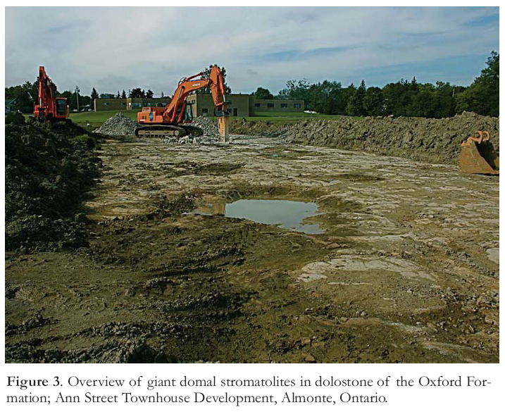
LESSONS PROVIDED BY THESE CASE STUDIES OF GEOHERITAGE-RELATED PROJECTS
9 The Metcalfe Geoheritage Park project provides a case study of how easily the public can be made aware of the importance of their geoheritage, and will soon offer a new setting for geoeducation via a varied outdoor display. Such displays, as previously mentioned, have been created elsewhere in Canada (Waterloo, Haileybury, Regina, and St. John’s), but the new rock display in Almonte is the first to be designated as a municipal Geoheritage Park in Canada – and perhaps in the world. The geoscience-awareness potential of such displays is tremendous. By simply initiating such a project, not only can a greater appreciation of the importance of geoheritage be swiftly established, but considerable goodwill can be generated for the geoscience community.
10 The Highway 417 and Almonte megastromatolite projects have both revealed the need for legislation to better protect geological wonders. Although we have been successful, so far, in gaining support for the preservation of representative specimens of biofilm structures in siliciclastic sandstone along Highway 417 that would otherwise be destroyed, and have found possible avenues for preserving a part of an outstanding new exposure of megastromatolites in Almonte, there are many instances of significant and unique geological treasures being completely destroyed. The type locality for perthite, for instance, now lies buried beneath a highway in Ontario. Why should not geoheritage sites be afforded protection at least to the level now provided for archaeological sites? A concerted move by the geoscience community to bring about appropriate legislation is long overdue. In Australia, their national Heritage Commission has drawn up a Natural Heritage Charter (Australian Heritage Commission 2002), and Britain has an active Nature Conservancy Council (Attenborough 1990) that works to protect values inherent in the abiotic world. These organizations can serve as models for the geoscience community to promote the adoption of substantive geoconservation measures in Canada.
11 Astoundingly, even where road building and construction threaten unique features in most parts of Canada, little to no effort is expended to record data from ephemerally exposed sections. Where such information is obtained, it is generally due to serendipitous observations by geoscientists who keep tabs on local projects, or simply fortuitously spot features of interest in a new road-cut or construction site. As public support of the geo-sciences is nurtured through the provision of appropriate programs to increase public awareness of things geological, we can expect that additional features of interest will be brought to the attention of geoscientists. The provision of seminars on local geology and geomorphology to workers who operate rock-smashing and earth-moving machines could enhance such feedback. The bottom line is that our extraordinary geoheritage must be more widely promoted to all segments of the Canadian public.
ACKNOWLEDGEMENTS
Neil Carleton of Tait McKenzie Public School in Almonte has been an essential member of our Metcalfe Geoheritage Park Working Group. Ben Cle-land of Almonte, who went on to obtain a degree in Geology from Carleton University, worked untiringly with us as a volunteer during the summer of 2003, the first year of our evolving initiative to introduce the geoheritage concept to Almonte. Kelly Currie and Julie Argue of Mississippi Mills Chamber of Commerce have graciously displayed our posters and distributed our pamphlets in the Almonte Visitors Centre. Mayor Al Lunney, and all Mississippi Mills Councillors have been supportive of our efforts. Calvin Murphy, in charge of the Mississippi Mills Parks and Recreation Committee provided liaison and advice throughout 2008. Cliff Bennett, President of MVFN, has been extremely helpful in advancing the project, as have members of his very active and scientifically astute group, including Pat Browne, who has provided much useful information about the megastromatolite site. Patricia Larkin of Nature Works Learning has provided liaison in organizing the movement of selected rock specimens to Metcalfe Geoheritage Park. Scott Newton of Mississippi River Power Corp. provided access to rock cuts recently created for the hydro plant in Almonte, from which several rock slabs have been selected for display in Metcalfe Geoheritage Park. Sullivan and Son Construction, Karson Group, Cavanaugh Construction, and Oliver Toop have provided rock specimen transport. Developers Adrian Shouten and Andrew Cinnamon of Parkview Homes met us on site to discuss possible preservation of a part of the recently exposed megastromatolite unit within the Ann Street subdivision. Phil Kor of Ontario Parks and Ewa Bednarczuk of the Ontario Ministry of the Environment were key players in arranging the Highway 417 georescue operation. Christy Vodden’s review of this paper provided many excellent suggestions for improvement.REFERENCES
Attenborough, D., 1990, Earth Science Conservation in Britain: A Strategy: Nature Conservancy Council, Peter-borough, UK, 84 p.
Australian Heritage Commission, 2002, Australian Natural Heritage Charter, Second Edition, Canberra, Australia, 25 p.
Donaldson, J.A., 2006, Friends of Canadian Geoheritage and the Ottawa-Gatineau Geoheritage Project: Where do we go from here? GAC–MAC, Montreal 2006, Program with Abstracts, p. 40.
Donaldson, J.A., 2003, Promoting geo-science through collaboration: The Ottawa-Gatineau geoheritage project: Geoscience Education Conference IV, Geoscience Education for the Global Community, Calgary, Proceedings, 4.
Donaldson, J.A., 2005, Friends of Canadian Geoheritage: A progress report: GSA Annual Meeting, Salt Lake City, [http://gsa.confex.com/gsa/2005AM/finalprogram/abstract_92224.htm.]
Donaldson, J.A., and Aylsworth, J.M., 2004, Expanding geoscience awareness through Friends of Canadian Geoheritage: GAC–[MAC, St. Catherine’s 2004, Program with Abstracts, [http://gac.esd.mun.ca/gac_2004/search_abs/sub_program.asp?sess=98&form=10&abs_no=151.]
Donaldson, A., and Hilowle, M.A., 2002, Organic mats, evaporite pseudo-morphs and soft-sediment deformation in quartz arenites of the Cambro-Ordovician Nepean Formation: GAC–MAC, Saskatoon 2002, Program with Abstracts, [http://gac.esd.mun.ca/gac_2002/search_abs/sub_program.asp?sess=98&form=10&abs_no=73]
Donaldson, J.A., Munro, I., and Hilowle, M.A., 2002, Biofilm structures, trace fossils and stromatolites in Early Paleozoic quartz arenites and carbonates of the Ottawa region, Ontario: Twelfth Canadian Paleontology Conference, Program and Abstracts, 12.
Donaldson, J.A., Chiarenzelli, J.R., and Aspler, L.B., 2005a, Cambro-Ordovician stromatolite occurrences in the Ottawa region: Geological Society of America, Northeastern Section, 40th Annual Meeting, Saratoga Springs, NY, paper No. 3-3, [http://gsa.confex.com/gsa/2005NE/finalprogram/index.html.]
Donaldson, J.A., Chiarenzelli, J.R., and Aspler, L.B., 2005b, Siliciclastic stromatolites and biofilm structures: Conditions for preservation: GAC–MAC–CSPG–CSSS Halifax 2005, Abstracts, p. 45-46.
Gray, M., 2004, Geodiversity: valuing and conserving abiotic nature: Wiley, 434 p.
Hilowle, M.A., Donaldson, J.A., Arnott, R.W.C., 2000, Biofilm-mediated structures in quartz arenites of the Cambro-Ordovician Nepean Formation. GeoCanada2000 – The Millenium Geoscience Summit, Calgary, conference CD, [www.ironleaf.com, abstract 868.]
Nowlan, G.S., and Schreiner, D., 2007, The state of earth science outreach in Canada and an action plan for the future: Results of a session and workshop held in Yellowknife, NWT, May 24-27, 2007: Geoscience Canada, 34, p. 49-54.