Government Geoscience Stimulates Mineral Exploration in the Superior Province, Northern Québec
Alain LeclairGéologie Québec, 880, Chemin Sainte-Foy, bureau 3.50, Québec, QC, G1S 4X4, Canada
Jean-Yves Labbé
Géologie Québec, 880, Chemin Sainte-Foy, bureau 3.50, Québec, QC, G1S 4X4, Canada
Alain Berclaz
Géologie Québec, 545 Crémazie Est, bureau 1110, Montréal, QC, H2M 2V1, Canada
Jean David
GEOTOP-UQAM-McGill, CP 8888, Succ. Centreville, Montréal, QC, J9P 3L4, Canada
Charles Gosselin
Géologie Québec, 880, Chemin Sainte-Foy, bureau 3.50, Québec, QC, G1S 4X4, Canada
Pierre Lacoste
Géologie Québec, 545 Crémazie Est, bureau 1110, Montréal, QC, H2M 2V1, Canada
Louis Madore
Géologie Québec, 880, Chemin Sainte-Foy, bureau 3.50, Québec, QC, G1S 4X4, Canada
Charles Maurice
Géologie Québec, 400 boulevard Lamaque, bureau 102, Val d'Or, QC, J9P 3L4, Canada
Patrice Roy
Géologie Québec, 400 boulevard Lamaque, bureau 102, Val d'Or, QC, J9P 3L4, Canada
Kamal N.M. Sharma
Géologie Québec, 880, Chemin Sainte-Foy, bureau 3.50, Québec, QC, G1S 4X4, Canada
Martin Simard
Géologie Québec, 880, Chemin Sainte-Foy, bureau 3.50, Québec, QC, G1S 4X4, Canada
Submitted, 4 August 2005; accepted as revised, 22 June 2006
SUMMARY
This paper summarizes new geologic information, and highlights exploration opportunities in the northeastern part of the Superior Province since 1997, as a result of the Far North Program undertaken by Géologie Québec. The first phase of the program was a regional lake-sediment geochemical survey, where 26,000 samples were collected north of 55°N from an area of approximately 350,000 km2. The resulting database attracted many mining companies to the region and led to numerous mineral discoveries. The second phase, started in 1998, consisted of extensive geological mapping, supplemented by U-Pb geochronological work; by 2003, more than twenty, 1:250,000 mapping projects were completed. The Far North Program is now in its final phase and it will produce a comprehensive geological and metallogenic synthesis of the new data from the areas surveyed. About forty previously unknown volcano-sedimentary belts, numerous mafic-ultramafic intrusions and sixteen different mineral deposit types have been identified. Since 1997, this has resulted in a surge of exploration activity that has seen more than $38 million in expenditures by private industry.SOMMAIRE
Le présent article présente un résumé des nouvelles informations géologiques disponibles et décrit des cibles d'exploration mises au jour depuis 1997 dans le nord-est de la Province du lac Supérieur et qui découlent du programme d'exploration du Grand Nord de Géologie Québec. La première étape de ce programme a consisté en un échantillonnage géochimique régional de sédiments lacustres, où 26 000 échantillons ont été prélevés au nord du 55e parallèle, sur une superficie de près de 350 000 km2. La base de données ainsi constituée a attiré de nombreuses sociétés minières dans la région et de nombreuses découvertes minérales ont été faites. Amorcée en 1998, la deuxième étape a consisté en une cartographie géologique systématique, appuyée par des datations géochronologiques U-Pb. Et, en 2003, plus de 20 cartes à l'échelle 1:250 000 avaient été complétées. Le programme du Grand Nord en est maintenant à sa dernière étape, laquelle aboutira à la production d'une synthèse géologique et métallogénique à partir des nouvelles données provenant des régions étudiées. Environ une quarantaine de bandes volcano-sédimentaires, de nombreuses intrusions mafiques et ultramatiques, et seize types de gisements minéralogiques différents y ont été décrits. Depuis 1997, ce programme a entraîné des investissements d'exploration par l'entreprise privée dépassant les 38 M$.INTRODUCTION
1 Globalization of the mineral industry continues to generate marked interest in the mineral potential of mostly uncharted territories. The undiscovered mineral resources within such territories represents a significant amount of Canada's ultimate mineral wealth, and contributes to its sustained economic prosperity. In this context, the Precambrian rocks of the Canadian Shield, known for their numerous metal and diamond deposits, offer favourable prospects for future mineral exploration. Consequently, the continued growth of Canada's mining industry hinges on the acquisition of new geoscientific data from these unexplored frontier terrains, and on the development of predictive and conceptual models that will serve to guide mineral exploration activities.
2 Quebec is recognized as one of the most attractive places in the world for mineral potential and exploration investment climate (see Fraser Institute 2006). The province's rich mineral endowment can be largely attributed to the vastness of its land surface (~1.5 x 10⁶km2), 90% of which is underlain by Precambrian rocks of the Canadian Shield. The presence of several world-class metal deposits, such as Lac Tio (Fe-Ti), Mont Wright (Fe), Doyon and Sigma-Lamaque (Au), LaRonde (Au-Cu-Zn), Niobec (Nb), Raglan (Ni-Cu-PGE), Horne (Cu-Au), and Jeffrey (chrysotile, asbestos), attests to Quebec's vast and diverse mineral resource base. Although many regions have been extensively surveyed over the past 75 years, almost one third of Quebec remains essentially unexplored.
3 North of 55°N, in Nunavik, lies an immense and essentially unstaked region covering about 350,000 km2, or roughly 20% of Quebec (Fig. 1). This northeastern part of the Superior Province, with good exploration potential for gold, base metals and diamond deposits, represents the largest under-explored frontier region of exposed Archean crust in the Canadian Shield. To compensate for dwindling new discoveries in traditional mining districts like Abitibi, where exploration must target greater depths for additional deposits, poorly prospected areas farther north in the Superior Province are becoming increasingly attractive. Although considerable geologic information has been derived from extensive mapping, U-Pb geochronology, and Lithoprobe studies in the southern and western parts of the Superior Province, the northeastern segment of the province has received relatively little attention toward developing models of Archean evolution except for a few studies (e.g. Stern et al. 1994; Percival and Skulski 2000; Percival et al. 2001; Bédard et al. 2003). The knowledge base on which the nature, evolution, and mineral resource potential of the Superior craton is founded should include the northeastern segment, where Archean processes that are poorly manifested or absent elsewhere, may occur.
Figure 1. Regional setting of the Superior Province of Quebec, showing the subdivision into subprovinces (modified from Card and Ciesielski 1986) and neighbouring orogens draped over topographic relief. The location of the study area covered by the Far North Program in Nunavik (north of 55°N), is outlined.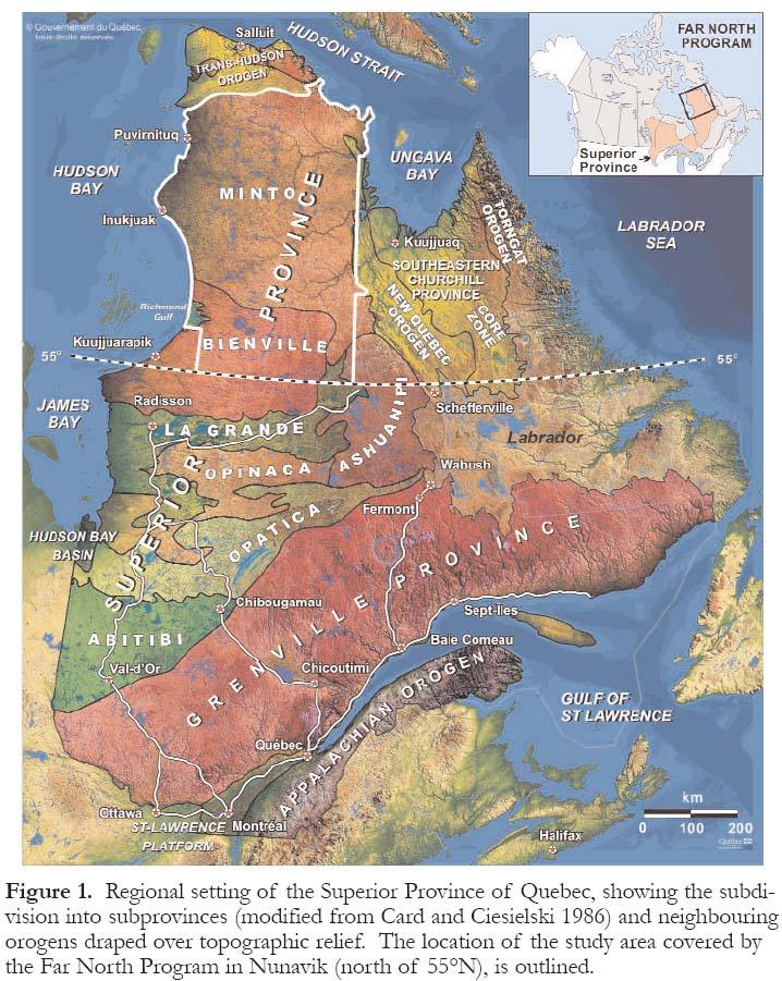
Display large image of Figure 1
4 In 1997, Géologie Québec (Ministère des Ressources naturelles et de la Faune du Québec, MRNF) launched the Far North Program in Nunavik (Caty et al. 1997; Leclair et al. 1998a, 1998b). New regional bedrock mapping, together with extensive U-Pb geochronology outline a complex record of deposition, magmatism, deformation, and metamorphism over the interval between 3.82 and 2.62 Ga, thus providing deeper insights into the evolution of the Superior Province (see Boily et al. 2006a; Leclair et al. 2006; Maurice et al. 2006; Stevenson et al. 2006). This mapping program also led to the discovery of several mineralized zones and previously unknown geological environments that may now be economically viable. As the multi-year Far North Program is in its final phase, a comprehensive and integrated geological and metallogenic synthesis of the large datasets obtained from regional mapping and related research will be completed in 2006. This paper presents a synopsis of the Far North Program and provides an overview of new perspectives on the regional geology and exploration potential of the northeastern Superior Province; this has resulted in a big surge in industry exploration.
NUNAVIK
5 Stretching across the Ungava Peninsula, Nunavik boasts more than 2000 km of coastline, but is devoid of any road or railroad access (Fig. 1). The western part forms an immense peneplaned landscape of gently rolling hills (100 to 300 m a.s.l.), gouged by several large rivers and dotted with countless lakes. The widely spaced and open subarctic taiga forest fades out north of the Feuilles River, giving way to the lowlying shrub flora of the arctic tundra. With only sporadic and discontinuous thin veneers of glacial drift, bedrock is exposed over much of the land surface allowing for systematic mapping and examination of well-exposed Archean geological features.
6 Nunavik, meaning "the land to live" in Inuktitut, is inhabited by a founding people that have a rich cultural heritage, deeply rooted in their vast homeland. Its 11,000 inhabitants, of which close to 90% are Inuit, live in 14 secluded coastal villages that are widely separated along the coast. An effective air and marine transportation system provides the essential goods and services to the residents and is fundamental in keeping the communities connected. Although more diversified than in the past, the Inuit have retained their traditions, skills, and knowledge, which are intimately related to hunting and fishing activities. Over the last few decades, the nomadic Inuit people have had to adapt to an urban lifestyle and face social issues that result from a difficult balancing act between traditional and modern ways of life. The future of the communities still lies in their ability to adjust to a changing world, while ensuring that their culture is not lost in the process.
7 The economic livelihood of Nunavik is based on the public sector, harvesting of renewable resources, the Raglan nickel mine, tourism, transportation, and the service industry. The vast and largely untapped mineral and water resources in northern Quebec could also be conducive to Nunavik's economic growth and could be part of its future prosperity. Activities associated with mineral exploration and mining development, for instance, have the greatest potential for creating jobs and generating revenues in remote northern communities. An important aspect of the action taken by the Quebec Government in the far north was to foster closer relations with these native communities by ensuring their full participation in the development of Nunavik's mineral resources. To that end, and as part of the Far North Program, the government provided financial assistance for the creation of the Nunavik Mineral Exploration Fund. Up to $300,000 is granted each year to support activities such as promotion of the mineral potential, raising awareness of mineral exploration, providing technical and financial assistance to propectors, training people in exploration and prospecting work, and helping to set up Inuit exploration firms.
SUMMARY OF PREVIOUS FIELD INVESTIGATIONS
8 The earliest recorded expeditions in search of minerals in Nunavik were carried out in 1744 and 1748 by officers of the Hudson's Bay Company, namely J. Langland, T. Mitchell, and W. Coats. Subsequent investigations were made in 1824 by Dr. Mendry, and in 1887 by Reverend E.J. Peck through overland excursions from Richmond Gulf to Fort Chimo (Kuujjuaq). These early European explorers gathered information on the physiography, wildlife, vegetation, climate, and mineral deposits of the region. The first geological reconnaissance surveys and comprehensive geological reports were done by Bell (1877, 1885) and Low (1889, 1898, 1902) of the Geological Survey of Canada (GSC), as they conducted a series of expeditions, between 1877 and 1903, in the coastal areas of the Ungava Peninsula and inland, along major rivers. The geology of the region was also briefly described along traverses across the peninsula via Lake Minto and Feuilles River (Fig. 2) by Flaherty (1918) and via Payne River, Payne Lake, and Kogaluk River by Aubert de la Rue (1948). Geological investigations were also carried out by Kranck (1951) along the east coast of Hudson Bay. Kretz (1960) made reconnaissance geological observations in the northern part of the Ungava Peninsula. Short descriptions of these early expeditions and other investigations in northern Quebec (see Vallières 1989), accompanied by their principal geological findings, are summarized in many of the geological reports referred to below.
9 The first systematic geological mapping of the Ungava Peninsula was undertaken by the GSC in the late 1950s and early 1960s. Two major helicopter-supported reconnaissance geological surveys were carried out over the area north of 52°N (known as New Quebec) by Eade (1966) and Stevenson (1968). Geological maps at a scale of 1:1,000,000 were produced based on field observations made from the air and at specific sites using a 10 km grid. A small volcano-sedimentary belt (Nuvvuagittuq belt) located about 30 km south of Inukjuak (Figs. 1, 3) was first mapped, at 1 mile to an inch, by Lee (1965). In 1973, Taylor (1982) produced a map, at 1:250,000 scale, of the Ungava Peninsula north of 61°N (Fig. 2). During the 1980s and 1990s, several mapping projects conducted by the MRNF and the GSC in the Cape Smith Belt (Trans-Hudson Orogen on Fig. 1) covered adjacent parts of the Superior Province (e.g. Lamothe et al. 1984; Moorhead 1988, 1989, 1996; Roy 1989; Togola 1992; St-Onge and Lucas 1993, 1997). Mapping of the New Quebec Orogen also included adjacent areas of the Superior Province (see Dimroth 1978; Dressler 1979; Clark and Wares 2004; references therein). Chandler (1988) mapped the Paleoproterozoic sequences in the Richmond Gulf area (Fig. 1). Between 1989 and 1996, Percival and co-workers of the GSC mapped at 1:500,000 scale a 400 km long by <100 km wide transect across the northeastern part of the Superior Province in the vicinity of the Feuilles River (Fig. 2; Percival and Card, 1994) and at 1:250,000 scale three other areas located farther north (Percival et al. 1995, 1996, 1997). During the summer of 1994, Lamothe (1997) produced a 1:50,000-scale map of the Dupire volcano-sedimentary belt located southeast of Lake Minto (Figs. 2, 3).
Figure 2. Simplified geological map of the northeastern part of the Superior Province (modified from Leclair 2005) showing boundaries of subprovinces redrawn on the basis of regional 1:250,000-scale mapping. Dashed lines indicate areas recently mapped by the GSC: (a) Percival and Card (1994), (b) Percival et al. (1995), (c) Percival et al. (1996) and(d) Percival et al. (1997). Numbers within NTS map areas refer to mapping projects carried out by the MNRF under the Far North Program: 1 - Povungnituk (35C) and Kovik Bay (35F) Areas, Maurice et al. (2005a); 2 - Lac Couture (35B) and lacs Nuvilik (35G) Areas, Madore et al. (2004); 3 - Lac Klotz (35A) and Cratère du Nouveau Québec (35H) Areas, Madore et al. (2002); 4 - Rivière Arnaud Area (25D) and adjacent coastal areas (25C-25E-25F), Madore and Larbi (2001); 5 - Kogaluk Bay Area (34M-34N), Maurice et al. (2005b); 6 - Lac Anuc Area (34O), Berclaz et al. (2005); 7 - Lac du Pélican Area (34P), Cadieux et al. (2004); 8 - Lac Peters Area (24M), Madore et al. (2000); 9 - Rivière Innuksuac Area (34K-34L), Simard et al. (2004); 10 -Lac Vernon Area (34J), Parent et al. (2003); 11 - Lac La Potherie Area (34I), Leclair et al. (2002a); 12 - Lac Dufreboy Area (24L), Leclair et al. (2003b); 13 - Lac Minto Area (34F-34G), Simard et al. (2005a); 14 - Lac Nedlouc Area (34H), Parent et al. (2001); 15 - Lac Aigneau Area (24E-24F), Berclaz et al. (2002); 16 - Lac à l'Eau Claire Area (34B-34C), Simard et al. (2005b); 17 - Lacs des Loups Marins Area (34A), Gosselin et al. (2002); 18 - Lac Maricourt Area (24D), Simard et al. (2002); 19 - Lac Montrochand Area (33O), Roy et al. (2004); 20 - Lac Bienville Area (33P), Gosselin et al. (2004); 21 - Lac Gayot Area (23M), Gosselin and Simard (2001).Figure 3. Distribution of principal mineral showings occurring in the northeastern part of the Superior Province and classified according to sixteen different mineral deposit types. The locations of the main volcano-sedimentary belts are indicated.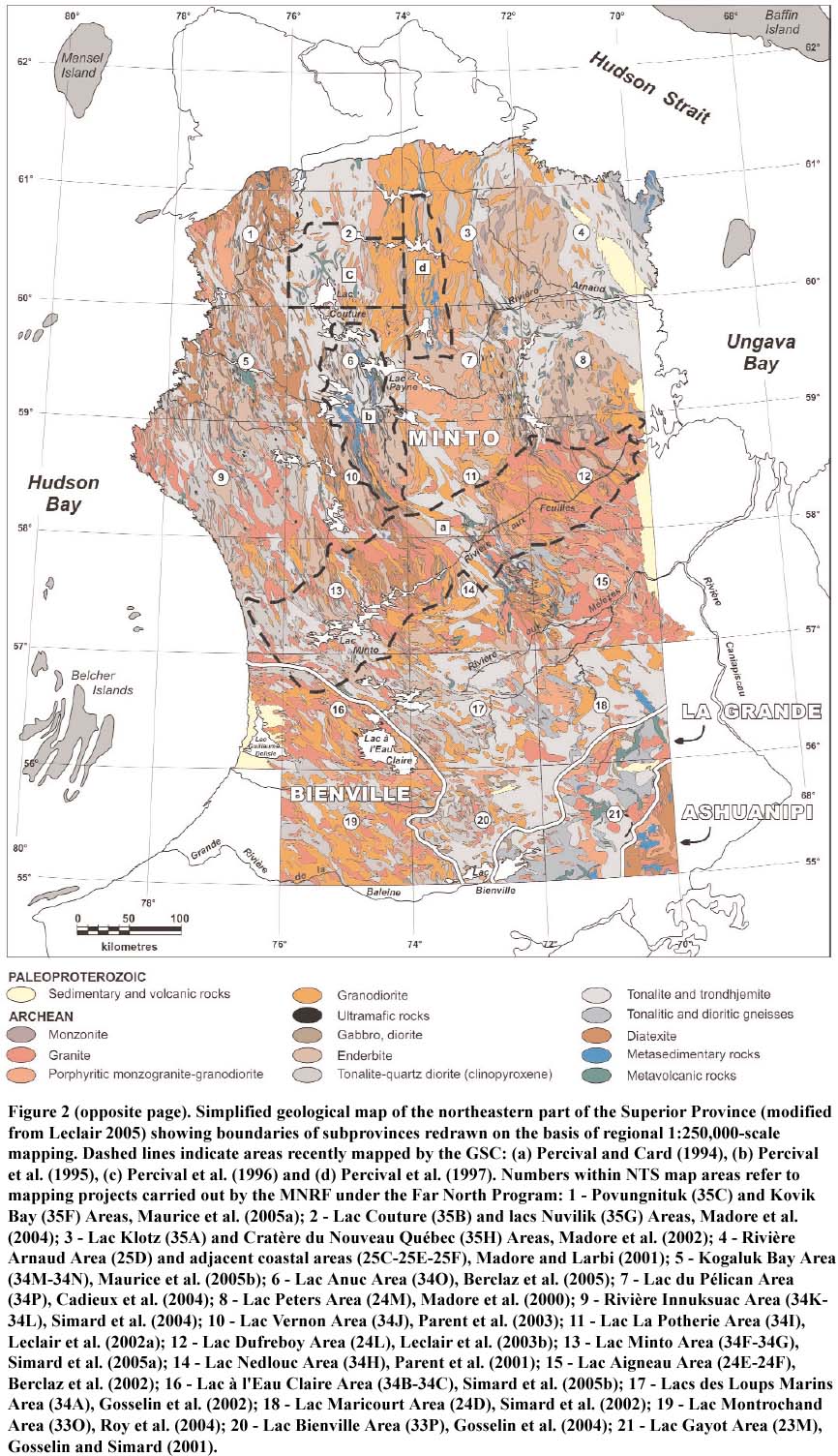

THE FAR NORTH PROGRAM
10 In the summer of 1997, the MRNF mandated SIAL Geosciences Inc. to carry out a major lake-sediment geo-chemical survey north of 55°N (Fig. 2). This survey marked the first phase of the Far North Program and was realized through a partnership agreement with five mineral exploration companies (Cambior, Falconbridge, Noranda, Soquem, Virginia Gold Mines). More than 26,000 lake-sediment samples were collected, with a sampling density of 1 sample per 12 km2, over a surface area that covers ~350,000 km2(43 NTS map sheets) in Nunavik. The geochemical database was released the following year (MRN 1998) and is now available on Quebec's Geomining Information System (SIGEOM) via the internet.
11 By providing the mining industry with useful geochemical background information for planning and development of an effective exploration strategy, the lake-sediment survey had an immediate effect on mineral exploration activity in the region. The presence of many multi-element geochemical anomalies attracted major and junior mining companies to the region. In 1998, thirty-seven new exploration permits covering a surface area of 3700 km2 were granted as a direct outcome of the survey and earlier geological mapping. Among grassroots exploration projects, Falconbridge undertook a reconnaissance program designed to follow-up on a series of Ni-Cu-Co geochemical anomalies, possibly associated with magmatic deposits in ultramafic rocks; and Soquem, Virginia Gold Mines, and Cambior coordinated their efforts to carry out prospecting work in the search for epigenetic gold, VMS, magmatic Ni-Cu and Cu-U (Olympic Dam type) deposits.
12 The geochemical database was also used to screen volcano-sedimentary belts (Labbé et al. 1999) – prime targets for gold and base-metal exploration in the early going. Gold and base-metal exploration actually began in 1992, following the discovery of the Vizien greenstone belt (Percival and Card 1992), and was further stimulated by the mapping of the Kogaluc, Qalluviartuuq-Payne, Duquet, Akuaraaluk (Percival et al. 1995, 1996), and Dupire belts (Lamothe 1997; Fig. 3). By 1998, a significant number of mineral discoveries had been reported in these belts (see Gaudreau 1999). This first important phase of exploration was undertaken by Cominco, Soquem, and Virginia Gold Mines.
13 The second phase of the Far North Program, started in 1998, will stand as the most ambitious and challenging regional mapping initiative undertaken, in the last two decades, in a remote area of the Canadian Shield. A total of twenty-one, 1:250,000-scale mapping projects (Fig. 2) were carried out between 1998 and 2003, covering much of the Superior craton between 55°N and the Trans-Hudson Orogen (Fig. 1). One additional mapping project was undertaken in the Koroc River area (Verpaelst et al. 2001), east of Ungava Bay in the southeastern Churchill Province (Fig. 1). The development of a general lithodemic/stratigraphic scheme for these new geological maps was facilitated by extensive U-Pb geochronological work at GEOTOP. A combination of conventional isotope-dilution (TIMS) and laser-ablation (MC-ICP-MS) dating methods have been applied to resolve magmatic and post-magmatic crystallization events and to unravel the complex inheritance history (David, in press). These data augment the existing geochronological database (cf. Skulski and Villeneuve 1999; Percival et al. 2001 and references therein). The metallogenic studies conducted in conjunction with the field work were mainly focused on documenting the geological setting and extent of mineralized zones found during regional mapping.
14 Given its magnitude and complexity, the Far North Program has called on a significant proportion of the human and financial resources of Géologie Québec. From the onset of the mapping campaign, a team of fourteen full-time project geologists has been assigned to the program, along with several technical and administrative workers. For the fieldwork component, a typical crew of six senior geologists and six assistants, supported by a helicopter, was required to ensure systematic coverage. Between 1997 and 2006, Géologie Québec has invested $25 million in the program, including $2.5 million for the lake-sediment geochemical survey.
GEOLOGICAL OVERVIEW
15 In this paper, the northeastern Superior Province (NESP) refers to the Archean rocks occurring north of 55°N, in Nunavik. It is bounded on the west, east, and north by tectonostratigraphic elements of the Paleoproterozoic Trans-Hudson Orogen, including the southeastern Churchill Province (Fig. 1; cf. Card and Poulsen 1998; St-Onge et al. 2000; Wardle et al. 2002). The NESP comprises the Minto and Bienville sub-provinces of Card and Ciesielski (1986, see also Card 1990). More recent work (e.g. Card and Poulsen 1998; Percival et al. 2001; Leclair 2005), suggests that the NESP contains Archean rocks belonging to the Minto subprovince (also called the Minto block), as well as the Bienville, La Grande, and Ashuanipi subprovinces (also called the Ashuanipi Complex). These rocks are cut by Proterozoic mafic dyke swarms (cf. Buchan et al. 1998; Buchan and Ernst 2004), small lamprophyre, and alkalic rock-carbonatite plugs and dykes, and are overlain by scattered outliers of Proterozoic and Phanerozoic sedimentary cover (see reports listed in Fig. 2).
16 The NESP is characterized by a strong positive magnetic anomaly and consists of plutonic rocks mainly and sporadic supracrustal belts ranging in age from Eo- to Neoarchean. Its key features include an abundance of Neoarchean rocks; a significant proportion of ancient (>2.8 Ga) crust; sparse volcano-sedimentary sequences enclosed in coeval tonalite-trondhjemite plutonic suites; voluminous granodiorite, granite, and pyroxene-bearing plutons (<2.74 Ga); steep structures and plutonic sheets with northerly trends; and widespread high-T/low-P metamorphism (e.g. Percival and Skulski 2000; Leclair et al. 2001, 2003a, 2006).
17 Most of the NESP was previously classified as "high-grade gneiss" or "granulite" terrain (i.e. Minto sub-province; Card and Ciesielski 1986) based on reconnaissance investigations that reported the widespread occurrence of metamorphic pyroxene (Eade 1966; Stevenson 1968; Herd 1978). The Minto subprovince was later designated as one of Earth's largest granulite terrains. It consists of pyroxene-bearing plutonic rocks (i.e. igneous charnockites), hornblende-biotite granitoid rocks, and remnants of supracrustal sequences (Percival et al. 1992, 1994; Bégin and Pattison 1994; Percival 1994; Stern et al. 1994). More recent studies reveal a composite terrain of distinct geologicaeromagnetic domains composed mainly of plutonic rocks, including charnockites, and sparse amphibolite- to granulite-facies supracrustal remnants (Card and Poulsen 1998; Percival and Skulski 2000; Percival et al. 2001; Leclair et al. 2004). The results obtained by Géologie Québec from systematic mapping coverage indicate the presence of a wide variety of biotite-, hornblende- and pyroxene-bearing plutonic rocks, ranging in composition from felsic to ultramafic, and numerous, isolated belts of variably metamorphosed volcanic and sedimentary rocks (Fig. 2; Leclair 2005). The supracrustal belts are unevenly distributed throughout the region, and some occur in areas previously thought to contain only granitoid rocks. Thus, the Minto subprovince can now be more accurately defined by a terrain dominated by plutonic rocks enclosing remnants of supracrustal belts. It should no longer be regarded as a genuine "high-grade gneiss" or "granulite" terrain but rather as a composite "volcano-plutonic" terrain.
18 The prominent N- to NW-structural grain that characterizes the Minto subprovince (Fig. 2) is clearly defined by broad aeromagnetic anomalies. In general, pyroxene-bearing rocks, granites, and granodiorites have higher magnetic susceptibilities than metavolcanic and metasedimentary rocks (except iron formation) and associated tonalites and diatexites (Pilkington and Percival 1999, 2001; Leclair et al. 2002a). The high positive anomalies are generally associated with relatively young granitic-enderbitic plutonic massifs (30– 80 km wide). The N- to NW-oriented aeromagnetic trends are superimposed on a background of magnetic lows corresponding to older supracrustal and tonalitic rocks (Fig. 2). The overall magnetic pattern shows evidence of dextral shear deformation, which produced sigmoid geometry with some oblique offsets, and late transverse faults.
19 The NESP is dominated by foliated plutonic rocks consisting of tonalite-trondhjemite (40%), granite (20%), granodiorite (15%) and enderbite, along with subordinate opdalite, charnockite and mangerite (15%). Small and isolated intrusions of diorite, gabbro, gabbronorite, ultramafic rocks, monzonite, syenite and anorthosite constitute about 2% of the area. Most plutonic rocks occur as N- to NW-trending, steeply dipping (>65°) intrusive sheets commonly displaying well-preserved igneous textures. The rocks contain abundant mafic enclaves and bands of metavolcanic and metasedimentary rocks, which altogether account for close to 8% of the area. Supracrustal rocks form anastomosing networks of small, linear belts (<20 km wide by <120 km long) separated by broad plutonic complexes (Fig. 2; Leclair 2005). The supracrustal (greenstone) belts are lithologically diverse and include basalt, greywacke, pelite, and iron formation, along with lesser andesite, dacite, rhyolite, ultramafic rocks, conglomerate, and carbonate rocks. Lithological sequences of ultramafic to mafic, mafic to felsic, and intermediate to felsic compositions have been documented in the well-studied belts (cf. Percival and Card 1992; Skulski and Percival 1996; Lin et al. 1996; Percival and Skulski 2000; Labbéet Lacoste 2001; Lafrance 2001; Boily et al. 2002; Berclaz et al. 2003, 2005; Leclerc 2004). While broad similarities exist among some of the most coherent volcano-sedimentary sequences in terms of lithology and age, a precise belt-to-belt correlation is tenuous, reflecting the scarcity of available detailed mapping and because rocks in different belts have contrasting ages and structural histories. The supracrustal rocks are generally metamorphosed to amphibolite facies, less commonly to granulite facies, and rarely to greenschist facies. Many of these rocks partly retain their primary structures and textures despite the intense deformation and metamorphic overprints in almost all supracrustal belts.
20 The integration of various datasets obtained during the Far North Program and from published studies (see Percival et al. 2001 and references therein) reveals a very complex geological history spanning over 1.2 billion years. Indeed, the NESP preserves a remarkable record of deposition, magmatism, deformation, and metamorphism, which attests to several episodes of crustal growth and reworking between ca. 3.82 and 2.62 Ga (Percival and Skulski 2000; Percival et al. 2001; Berclaz et al. 2004; Leclair et al. 2002b, 2004, 2006; David, in press). The principal aspects of this record are, (1) the prevalence of Neoarchean rocks, (2) the presence of scattered remnants of Mesoarchean rocks, and (3) the preservation of cryptic Eo- to Paleoarchean crust which includes the oldest known volcano-plutonic complex (ca. 3.8– 3.6 Ga Nuvvuagittuq belt; David et al. 2003; Nadeau 2003) in the Superior Province. As suggested by the extensive zircon inheritance history (Percival et al. 2001; David, in press), the Meso- to Eoarchean crustal components were variably assimilated by magmas produced during several episodes of pervasive Neoarchean magmatism and reworked by deformation and metamorphism. The U-Pb geochronological results indicate that more than 90% of the plutonic and supracrustal rock units exposed in the region are Neoarchean. In addition, Nd isotopic data suggest that the distribution of ancient crust was much wider than that currently preserved at the surface. The pattern of zircon inheritance and Nd model ages is very complex, implying that episodic crustal growth involved an efficient recycling of earlier crustal material throughout the magmatic evolution of the region. Crustal evolution studies involving geochemical and isotopic analyses (Stern et al. 1994; Skulski et al. 1996; Skulski and Percival 1996; Rabeau 2003; Maurice et al. 2003, 2006; Stevenson et al. 2006; Boily et al. 2004, 2006a, 2006b) indicate that most Neoarchean volcano-plutonic complexes in the southern and western parts of the region were significantly contaminated by an older (3.8– 3.0 Ga), isotopically evolved, sialic crust, whereas those in the north are generally characterized by relatively more juvenile signatures and model ages of <3.0 Ga.
21 Based on results from recent mapping and structural, geochronological, geochemical, and isotopic studies (e.g. Percival et al. 2001; Berclaz et al. 2004; Leclerc 2004; David et al. 2003; Leclair et al. 2006; Maurice et al. 2006; Boily et al. 2006a, 2006b), the evolution of the NESP can be summarized in terms of four main periods, as follows:
- 3.82– 2.90 Ga – formation of protocratonic masses covering the entire southern and western parts of the region, and small, scattered crustal fragments (<3.0 Ga) in the northern part. Field evidence for this ancient crust is limited to a few remnants of supracrustal and plutonic rocks preserved in the Nuvvuagittuq belt and rare enclaves of tonalitic gneiss.
- 2.88– 2.74 Ga – deposition of sequences of tholeiitic basalt, komatiite, felsic tuff, iron formation, and abundant clastic sedimentary rocks, accompanied by the emplacement of voluminous, synvolcanic tonalite-trondhjemite plutonic suites and coeval deformation. Mafic to ultramafic intrusions are commonly associated with the volcanic sequences.
- 2.74– 2.68 Ga – transition to more common intermediate, felsic, and bimodal calc-alkalic volcanism, and widespread emplacement of syntectonic granite-granodiorite, enderbite-charnockite, tonalite-diorite, and mafic-ultramafic plutons across the entire region. Coeval craton-scale deformation is associated with the development of the N- to NW-trending regional foliation, and high-temperature metamorphism is associated with the formation of migmatitic diatexites.
- 2.68– 2.62 Ga – emplacement of small post-tectonic granite, nepheline syenite, and carbonatite intrusions, and protracted post-metamorphic hydrothermal activity focused mainly along fault zones.
MINERAL EXPLORATION
Initial Results of the Far North Program
22 The release of new mapping results, backed by easy access to capital and generous tax incentives from the Quebec government (Caty and Lacroix 2004), has sparked a surge of exploration activity in the underexplored NESP. This was achieved despite a cyclical downturn in the mining industry that occurred between 1998 and 2003. As seen in Figure 4, some companies reacted positively to exploration opportunities in the north by acquiring new exploration permits over the past dozen years. The graph shows a net increase in investments by the private sector between 1992 and 2005, which remained roughly in sync with public investments and continued upon completion of the mapping program. The first permit acquisitions during that period can be attributed to reconnaissance mapping of relatively well-preserved volcano-sedimentary rocks (Vizien, Kogaluc, Qalluviartuuq-Payne, and Duquet belts; Fig. 3) by the GSC. Then came the Far North Program of Géologie Québec, which led to the identification of additional exploration targets from the lake-sediment geochemical survey and from the geological mapping.
23 The initial mapping projects in the Gayot, Nedlouc and Peters lakes areas (Fig. 2; #21, 14 & 8, respectively) revealed the presence of several new volcano-sedimentary belts that have good gold and base-metal potential (Labbé et al. 1998). In the Gayot Lake area, Virginia Gold Mines and partner BHP Minerals discovered several Ni-Cu-PGE showings in komatiitic lavas and ultramafic intrusive rocks of the Vénus volcano-sedimentary belt. Makamikex also reported massive sulfides with 13.8% Cu in ultramafic rocks of the Charras belt (Fig. 3) in the same area. Major uranium geochemical anomalies in lake sediments (see Beaumier et al. 2006) led Soquem and Cambior to undertake grassroots prospecting work in granitic rocks in the Nedlouc Lake area. The consortium Soquem-Cambior-Virginia Gold Mines discovered polymetallic mineral showings of volcanogenic affinity in the Tasiaalujjuaq belt located in the Peters Lake area. It also explored in the Kogaluc, Qalluviartuuq-Payne, and Duquet belts (Fig. 3).
24 The Nunavik Exploration Fund started its activities during the summer of 1999, focusing on Ni-Cu exploration in the Povungnituk area (Fig. 2; #1). A dozen new exploration permits were registered that same year, bringing the total to 49 active permits in the far north region, of which about half were located in the newly mapped areas. Total exploration expenses reached an all-time high of $6.2 million as major exploration work for nickel, copper, zinc, silver, and gold was carried out in most of the volcano-sedimentary belts. Thus, the first two years of the Far North (mapping) Program had an immediate effect on the level of exploration in the northeastern Superior Province by defining potential targets in seven newly mapped areas.
Figure 4. Histogram comparing expenditures incurred by the public and private sectors between 1987 and 2005 in the mapped area corresponding to the Far North Program.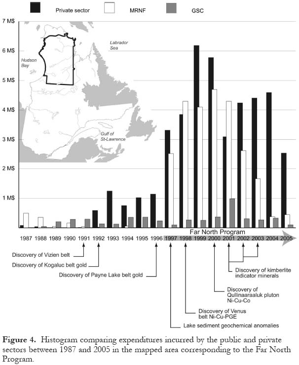
Display large image of Figure 4
25 At the end of August, 2000, the MRNF announced the discovery of the significant Qullinaaraaluk Ni-Cu showing (Labbé et al. 2001), which had been found in an ultramafic intrusion during regional mapping of the northern part of the Minto Lake area (Fig. 2; #13). This discovery highlighted a new type of setting for nickel mineralization in ultra-mafic intrusive rocks of the region, where Ni-Cu-Co-PGE deposits were already known to be associated with komatiitic rocks in greenstone belts. Soquem obtained the exploration licence and concluded a joint venture agreement with Falconbridge to explore the property the following year. These two companies conducted a helicopter-borne Mag-EM survey, ground EMH surveys, and regional prospecting work to investigate the Ni-Cu-PGE potential of several mafic-ultramafic intrusions in the same area. They discovered several showings in these intrusions (e.g. Larocque and Laferrière 2003); exploration for Ni-Cu-PGE remained at the forefront during the next few years.
26 The search for diamondiferous kimberlites was also a priority during the Far North Program because the northern part of the Superior craton possesses many characteristics common to diamond-producing areas (Moorhead et al. 1999, 2000). The region's appeal increased after Ashton Mining, in a joint venture partnership with Soquem, announced in December 2001 that diamonds had been extracted from two kimberlites located in the Otish Mountains region, approximately 400 km northeast of Chibougamau (Fig. 1). Over the last few years, the search for diamondiferous kimberlites has been extended northward beyond the initial area of success to include the rest of the Superior craton in Quebec's far north.
27 Several promising target areas for diamond exploration were identified as a direct result of the MRNF's Far North Program and the GSC's Targeted Geoscience Initiative. For instance, occurrences of kimberlite indicator minerals were discovered during the course of a joint GSC-MRNF survey of esker sediments (Parent et al. 2002, 2004; Beaumier et al. 2002a, 2002b, 2004). Picroilmenite grains having high chromium and magnesium contents, as well as grains of magnesian chromite, eclogitic garnet, and diopside typical of a diamondiferous mantle source, were reported in several samples collected from within map areas located between 55°N and 57°N (Fig. 2). The indicator minerals occur within or close to two major structural zones (the Saindon-Cambrien and Mistassini-Lemoine zones of Moorhead et al. 2000, 2003), which also contain G9 garnets, chrome diopsides, and perovskites (Girard 1999).
28 Farther north, a swarm of carbonatite and lamprophyre dykes was outlined in the course of mapping the Aigneau Lake area (Fig. 2, #15; Berclaz et al. 2002). Some ultramafic lamprophyre dykes appear to have kimberlitic affinity, based on preliminary petro-chemical studies (Lemieux et al. 2001). In the northern part of the region, the Allemand-Tasiat zone hosts several alkaline intrusions (Moorhead et al. 1999, 2000), including the Kuuvvaluk ultra-mafic lamprophyre diatremes (Madore et al. 2004). In addition, a nepheline syenite intrusion was located along the southern extension of the Allemand-Tasiat zone in the l'Eau Claire Lake area (Fig. 2, #16; Simard et al. 2005b). Mapping in this area also outlined a swarm of diabase dykes and associated diatreme breccias, which were emplaced in the main E– W rift associated with the Richmond Gulf zone (Simard et al. 2005b). A compilation of regional-scale lineaments interpreted from aeromagnetic and gravity maps shows intersecting zones of lineaments that could be conducive to kimberlite emplacement (Labbé 2001). Some of these lineaments coincide with late brittle structures and cross the major structural zones in proximity to alkaline intrusions. Another potential target for diamond exploration has been identified in the Arnaud River area (Fig. 2, #4; Thériault 2003), based on geological and structural features and geochemical signatures associated with ultramafic rocks. These new findings have led to follow-up exploration for diamonds in the northeastern part of the Superior craton.
29 As a result of the Far North Program, a greatly expanded geological database including results of rock geochemistry and U-Pb geochronology, is now available for this part of the Superior Province (cf. geological reports listed in Fig. 2). Géologie Québec's website [www.mrnf.gouv.qc.ca/mines/] provides online access to all publications, and to the field database in a variety of digital formats. More work is underway to bring all the datasets into a comprehensive regional synthesis. This synthesis and the resulting new geological map (Fig. 2; Leclair 2005) will provide an improved geological and geochronological framework for the area, which will help to better understand the nature, evolution, and mineral resource potential of the Superior Province.
Metallogenic Outlook
30 The more than 160 mineralized zones discovered, to date, suggest favourable environments for several types of ore deposits (e.g. Au in iron formation, Au-Cu-Zn volcanic-hosted massive sulfides, Ni-Cu-PGE in ultramafic rocks, U in veins and sedimentary rocks, etc.). These deposits are described in the geological reports listed in Figure 2 and in the assessment reports filed by exploration companies. In this section, we summarize the main results of a regional metallogenic study (Labbé and Lacoste, in press) conducted in conjunction with the mapping program.
31 The deposits observed in the studied area are mainly associated with Archean rocks and also occur in adjacent Proterozoic strata resting unconformably on Archean basement. Most of the known mineral occurrences are contained in sequences of volcanic and sedimentary rocks, but some are found in plutonic suites. Figure 3 shows the distribution of the principal mineral showings, which have been classified into sixteen different mineral deposit types.
Algoma-type Fe
32 Two Fe deposits are associated with Algoma-type iron formation and occur within a band of volcano-sedimentary rocks located near the Grande Baleine River (Fig. 2) in the southwest corner of the region (Eade 1966). These deposits were prospected during the 1950s by several mining companies, and were estimated at 538 Mt grading 36.7% Fe and 148.5 Mt grading 36.8 % Fe, respectively. Elsewhere, thick horizons of magnetite-rich iron formation, such as those found in the Dupire (Lamothe 1997; Parent et al. 2001), Payne (Berclaz et al. 2005), Kogaluc (Parent et al. 2003), Thury (Madore et al. 2000) and Mézard (Berclaz et al. 2005; Maurice et al. 2005b) belts, may also contain significant iron resources.
Volcanic-hosted Massive Sulfides
33 Many volcano-sedimentary belts of the region host polymetallic deposits and alteration zones that can be considered typical of volcanic-hosted massive sulfide deposits (Labbé and Lacoste 2001). The deposits are commonly associated with relatively small lenses of felsic effusive and tuffaceous rocks within basalt-dominated sequences containing clastic sedimentary rocks and iron formations. The metamorphosed alteration zones are characterized by the presence of various combinations of anthophyllite, cordierite, garnet, staurolite, biotite and/ or andalusite. Such alteration zones are especially well developed in volcano-sedimentary rocks in the Duquet, Nantais, Qalluviartuuq, Tasiaalujjuaq and Vizien belts (Fig. 3). In the Duquet belt, for example, polymetallic sulfides giving values up to 10.4% Cu, 7.4% Zn, and over 10 g/t Au (Bourassa 2002; Madore et al. 2004; Labbé and Lacoste, in press) provide a prime target for VMS exploration.
Magmatic Ni-Cu-PGE
34 During the last three years, base-metal exploration in the region was mainly focused on the search for large, economically viable deposits of nickel, copper and platinum-group-elements associated with mafic and ultramafic rocks. Two distinct subtypes are recognized: (1) Ni-Cu-PGE mineralization associated with ultramafic rocks (komatiite, peridotite) in volcano-sedimentary sequences and (2) Ni-Cu-PGE mineralization associated with mafic and ultra-mafic (pyroxenite, peridotite) intrusions.
35 Since the first reported occurrences in 1998 of Ni-Cu sulfides in the Venus belt (Gosselin and Simard 2001), follow-up exploration work has resulted in the discovery of several high-grade Ni-Cu-PGE showings distributed over a strike length of 25 km (Chapdelaine and Archer 2003). Massive, net-textured, and disseminated sulfides occur at the base of, or within, thick fractionated and thin spinifex-textured ultramafic (komatiite) flows. The Ni-Cu-PGE showings of the Venus belt bear many similarities to known ore deposits such as Kambalda and Mount Keith, which occur in Archean greenstone belts in Western Australia (Lafrance 2001; Chapdelaine and Archer 2003). Geochemical data suggest that volcanic rocks in the Buet, Payne, and Nuvvuagittuq belts (Fig. 3) also have an interesting potential for PGE mineralization (Labbé 2005).
36 In the summer of 2000, the discovery of massive sulfides in ultramafic intrusive rocks located north of Minto Lake (Qullinaaraaluk Ni-Cu-Co showing; Labbé et al. 2001; Parent et al. 2003) provided a new type of deposit in the Archean rocks of the far north. The sulfide deposit, which contains up to 2.6% Ni, is hosted by a small, late-kinematic pluton of pyroxenite that crosscuts diatexites of sedimentary origin. This discovery opened up new possibilities for the exploration of metallic ore deposits, which had previously been largely focused on greenstone belts. Subsequent exploration efforts revealed the presence of several Ni-Cu-PGE showings (Fig. 3) associated with the mafic and ultramafic rocks of the Qullinaaraaluk suite (Simard et al. 2004, 2005a, 2005b; Labbé and Lacoste, in press). Hence, the mafic and ultramafic intrusions of the region, some of which have compositional and geochemical characteristics comparable with those of the Qullinaaraaluk pluton (Baker 2005; Chevé 2005), constitute a highly prospective metallotect for magmatic Ni-Cu-PGE deposit.
Fe-Ti-V in Mafic Intrusions
37 The only reported Fe-Ti-V deposit associated with mafic intrusive rocks is located in the Kogaluk Bay area (Maurice et al. 2005b). It consists of massive magnetite and titanite and occurs in a layered gabbro-anorthosite sill intruding volcano-sedimentary rocks of the Roulier belt (Fig. 3). A sample from a mineralized layer containing 85% oxide minerals returned values of 14% TiO2 and 5321 ppm V.
Low-grade U-Th in Granites
38 Results of the lake-sediment geochemical survey revealed several uranium anomalies (Beaumier et al. 2006), with up to 1900 ppm U, in the Nedlouc Lake area (Fig. 2, #14). Prospecting work indicates that these anomalies can be linked to porphyritic granites that have higher U and Th contents than the surrounding units (Quirion 1999). The U occurrences are syngenetic and appear to bear some similarities to the world-class Uranium deposit of Rössing in Namibia (Laznicka 1993), which is characterized by low-grade ore (approx. 350 ppm U) but very high tonnage (138,000 t U).
Polymetallic Disseminated Sulfides
39 This deposit type encompasses many showings of disseminated sulfides (Fig. 3) whose precise origin remains undetermined. The pyrite-pyrrhotite disseminations, which are enriched in Ag, Cu, and/or Zn, occur in both volcanic and sedimentary rocks, as well as in some intrusive rocks. They are generally associated with strongly deformed rocks and may be spatially linked to major NW-trending fault zones (see compilation map by Leclair 2005). Overall, the mineralized zones are relatively discontinuous, and their metal contents can be fairly high (ranging up to 40.5 g/t Ag, 2.4% Cu, 4.72% Zn). Some zones also show moderately anomalous values in Pb, Au, Ni, Co, Cr and Mo. The disseminated Ag-Cu-Zn sulfide deposits observed in the region are probably of limited importance, and do not currently constitute a priority exploration target.
Disseminated Au
40 Zones of disseminated sulfides containing Au occur in sheared rocks of both volcanic and sedimentary derivation, and are distinguished from the previous type by having much higher gold contents. For example, several gold showings (called Pointe-aux-Gossans; Poirier 1994; Berclaz et al. 2005) near Qalluviartuuq Lake have returned values between 27 and 50 g/t Au. The mineralized zones, which generally have limited surface area (>1.5 m wide), may have formed by the remobilization of earlier gold concentrations in other deposit types. In some cases, the gold occurrences may be mesothermal in origin (Labbé and Lacoste, in press).
Au in Iron Formation
41 Gold hosted by iron formation represents one of the first and most important exploration targets in the NESP. Most of the volcano-sedimentary belts contain numerous iron formations, some of which include gold-bearing gossans (cf. reports listed in Fig. 2; Percival et al. 1995, 1996). The significant gold showings of this type are found in the northwestern part of the region, in the Payne (Berclaz et al. 2005), Kogaluc and Narsaaluk belts (Parent et al. 2003; Fig.3). The iron formations are complexly folded, and the gold occurrences are generally associated with shear zones (Lin et al. 1995). Gold mineralization is interpreted to be roughly synchronous with the main regional deformation (D3). Subsequent deformation (late-D3) is responsible for the remobilization of gold into thin sulfide veins emplaced along shear planes (Chapdelaine 1999; and references therein).
Au in Quartz Veins
42 Auriferous quartz veins have been found in association with volcano-sedimentary rocks only in the Duquet and Fagnant belts (Fig. 3). The rarity of this type of gold mineralization is partly related to the pervasive metamorphism (amphibolite to granulite facies) that affected most of the volcano-sedimentary belts. Metamorphic grade in the Duquet and Fagnant belts (and in the core of the Qalluviartuuq-Payne belt) is at green-schist or lower amphibolite facies, with P and T conditions as low as about 525°C and 3 kbar (Percival and Skulski 2000; Ciesielski 2000; Madore et al.2004; Leclerc 2004; Berclaz et al. 2005). Gold-bearing quartz veins in the Duquet belt are a late stage phenomenon compared to other deposit types in the same area. At one locality, visible gold has been identified in samples assaying up to 75 g/t Au (Veine showing; Chapdelaine and Villeneuve 2000).
Metasomatic REE in Marbles
43 The Kimber belt (Fig. 3) contains a calcite marble horizon, roughly 2 km long by >10 m wide, intercalated in a sequence of mafic metavolcanic rocks and paragneiss. The marble has returned highly anomalous values of light rare-earth-elements (La, Ce, Nd), which locally reach 1.59% (REE)2O3 (Lataille showing; Madore et al. 2002).
44 The average rare earth content of fifteen samples analyzed is 0.25% (REE)2O3 (Labbé et al. 2003). Allanite is the host rare earth mineral and occurs mainly as finely disseminated grains throughout the rock. Allanite grains visible to the naked eye are also present in veins (>1 m wide) of remobilized and recrystallized, coarse-grained marble. The marble horizon may be of sedimentary origin, based on its stratigraphic field relations with adjacent volcano-sedimentary units and on comparative lithogeochemistry (Labbé et al. 2003). It is located within a structural zone that essentially coincides with the boundary between major geological domains (cf. Leclair 2005); two plutons of nepheline syenite were emplaced in this zone (Kimber suite; Madore et al. 2002). The REE mineralization is probably epigenetic and may correspond to an episode of meta-somatism associated with the emplacement of the Kimber alkaline intrusions (Labbé et al. 2003).
U Veins
45 Uranium-bearing veins have been observed in two separate areas of the NESP (Fig. 3). In the Nedlouc Lake area, two vein-type uranium showings are associated with porphyritic granites enriched in uranium and thorium (see section Low-grade U-Th in Granites, page 69). The uraniferous veins are the result of hydromagmatic processes, which concentrated and remobilized the uranium into brecciated zones within the granites (Quirion 1999). Compared to the magmatic uranium deposits described above, these intragranitic veins are more local in distribution and contain much higher U values, with up to 0.13% U, 0.44% Th and 2.8% REE. In the vicinity of Guillaume-Delisle Lake (Fig. 2), uraniferous veins occur in fractured Archean rocks located in proximity to the unconformity with Proterozoic units of the Richmond Gulf Group. The highest U value obtained from selected samples is 1.31% U3O8 (Schumacher and Fouques 1979).
Cu-Co Quartz-Magnetite Veins
46 A few Cu-Co showings of this type are located to the northeast of Couture Lake (Fig. 3) along a regional brittle structure that cuts across deformed granodiorite (Cipmyluk showings; Madore et al. 2004). The chalcopyrite deposit is associated with quartz-magnetite veins that yielded up to 3.4% Cu and 731 ppm Co. These veins are accompanied by intense hematitization and silicification of the host rock. Locally, magnetite-rich breccia zones suggest certain similarities with iron oxide-copper-gold (Olympic Dam) type deposits (Labbé and Lacoste, in press). Quartz-magnetite-hematite veins giving anomalous Cu, Au, and Ag values occur along major brittle faults in other areas (e.g. Parent et al. 2001; Berclaz et al. 2002; Gosselin et al. 2002; Cadieux et al. 2004). The brittle nature of the structures containing the veins and the intense hematitization suggest that this deposit type may be Proterozoic.
Polymetallic Quartz Veins
47 Several late quartz±carbonate-sulfide veins located in the coastal area of Hudson Bay crosscut volcano-sedimentary and granitoid units of the Innuksuac River area (Fig. 2, #9; Simard et al. 2004). These undeformed planar veins are less than 40 cm in width and extend over several hundred metres. They contain high concentrations of chalcopyrite, galena and/or sphalerite. Some selected samples have yielded high values (>5%) for copper, lead, and zinc. However, the erratic nature of the mineralization suggests that the veins, probably of Proterozoic age, are of little economic significance.
Cu-Ag in Redbeds
48 Proterozoic basalts and some sedimentary members of the Richmond Gulf Group (Chandler 1988) located around Guillaume-Delisle Lake in the southwestern part of the region host redbed-type deposits containing chalcocite and bornite (Labbé and Lacoste 2004). Sulfides are either confined to amygdules or disseminated in the basalts. Some samples assayed up to 11% Cu and 80 g/t Ag, but based on our initial investigations, most showings appear to be of limited extent (1-2 m).
Sedimentary U
49 Two U deposits of this type are located in the northern part of the Gayot Lake area (Fig. 2, #21; Gosselin and Simard 2001), in an outlier of Paleoproterozoic sedimentary rocks resting unconformably on Archean basement. The deposits occur 20 to 40 m above the unconformity and are associated with a sequence of mudstone and siltstone. They consist of finely disseminated pitchblende, with minor chalcopyrite, pyrite and galena. The Gayot Lake uranium deposit contains reserves estimated at 50 Mt with an average grade of 0.10% U3O8.
Mississippi Valley-type Pb-Zn
50 A few showings of this type occur near Guillaume-Delisle Lake in a horizon of stromatolitic dolomite belonging to the Nastapoka Group in the Richmond Gulf graben (Chandler 1998; Labbé and Lacoste 2004). Centimetre-thick, coarse-grained galena- and sphalerite-bearing veins cut across this horizon. The principal mineralized zone (Ruby Lake deposit; Chandler 1998) is estimated at 525,000 tons containing 1.26% Zn and1.02% Pb.
CONCLUSIONS
51 This overview of the Far North Program synthesizes some of our knowledge of the geology and mineral exploration potential of the northeastern Superior Province in northern Quebec. The mapping projects carried out under this program have generated a wealth of well-archived geologic information that will serve the geoscience community for many years to come. Incorrectly considered to be a "high-grade gneiss" or "granulite" terrain in the past, the NESP is now known to contain a wide variety of rock types, including felsic to ultramafic plutonic rocks, volcanic rocks, and sedimentary rocks typical of "volcano-plutonic" and "metasedimentary" terrains. This new classification provides explorationists with a new and broader perspective of the geology and exploration potential of a previously uncharted area of the Superior Province. Furthermore, the new and enhanced geological framework developed for the NESP is underpinned by a large number of isotopic age determinations. This dataset provides researchers with basic information that will help decipher the geological complexities of this segment of the Superior craton. The next objective of the Far North Program is to release a comprehensive geological and metallogenic synthesis of the region at 1:750,000 scale.
52 The northeastern Superior Province has just begun to receive the attention that it deserves. While the Far North Program is an important step forward, it is not seen as an end in itself, but as a prerequisite to the prioritization of more detailed field-based studies and to the development of improved strategies for mineral exploration. Notwithstanding the new geoscience database, many problems remain unsolved, and their resolution will require further mapping in critical areas. It should also be stressed that, in spite of the recent activity, mineral exploration in the region is still at the grass-roots level. Against this background, a truly innovative approach to exploration is required for the discovery of mineral deposits in such a large territory. Accordingly, a long-term commitment involving a tripartite association among government surveys, mineral-deposit research groups, and exploration companies is essential for the discovery of new mineral resources in this complex Archean terrain.
ACKNOWLEDGEMENTS
The authors wish to thank all those who have been involved in the realization of the Far North Program and whose commitment and dedication were vital to its success. We are deeply indebted to geologists, too numerous to name, who participated in the mapping campaign. Special thanks are due to the following colleagues and collaborators for their contributions: M. Baker, D. Bandyayera,M. Beaumier, J. Bédard, M. Boily, Y. Bourassa, A.-M. Cadieux, S. Chevé, J. Choinière, D.-J. Dion, P. Ferron, D. Francis, L. Godin, N. Goulet, M. Hocq, I. Lafrance, Y. Larbi, F. Leclerc, M. Leduc, G. Lemieux, D. Lefebvre, P. Nadeau, Martin Parent, Michel Parent, O. Rabeau, R. Stevenson, R. Thériault and S. Turcotte. Thanks are also due to C. Grenier who helped with the figures. Comments by P. Verpaelst, M. Boily, and P. Thompson on an early version of the manuscript and thoughtful reviews by J. Percival, T. Clark, and an anonymous reviewer added greatly to the clarity of the paper.REFERENCES
Aubert de la Rue, E., 1948, Geological survey through the Ungava Peninsula: Arctic, v. 1, p. 135-136.
Baker, M., 2005, Pétrologie et métallogénie de l'indice de Ni-Cu-Co de Qullinaaraaluk et d'intrusions mafiquesultramafiques du domaine du lac Minto, sous-province de Minto, Québec [thèse]: Université Laval, Québec, 256 p.
Beaumier, M., Parent, M., and Paradis, S., 2002a, Exploration du diamant dans les sédiments d'eskers de la région du lac Bienville (33P) et dans les tills des régions des lacs Anuc (34O) et Vernon (34J): Ministère des Ressources naturelles, Québec, DP 2002-01.
Beaumier, M., Parent, M., and Paradis, S., 2002b, Minéraux lourds dans le till et exploration pour le diamant dans la région du lac Vernon (34J): Ministère des Ressources naturelles, Québec, ET 2002-02, 39 p.
Beaumier, M., Togola, N., Moorhead, J., and Faure, S., 2004, Diamonds, kimberlite pipes and deep-seated lineaments in Québec: Ministère des Ressources naturelles, Québec, Poster - [www.mrnf. gouv.qc.ca/english/maps/index.jsp].
Beaumier, M., Perreault, S., and Ouellet, S., 2006, Uranium in secondary environment geochemistry and mineralisations: Ministère des Ressources naturelles, Québec, Poster - [www.mrnf.gouv.qc.ca/ english/maps/index.jsp].
Bédard, J.H., Brouillette, P., Madore, L., and Berclaz, A., 2003, Archaean cratonization and deformation in the Northern Superior Province, Canada: an evaluation of plate tectonic versus vertical tectonic models: Precambrian Research, v. 127, p. 61-87.
Bégin, N.J., and Pattison, D.R.M., 1994, Metamorphic evolution of granulites in the Minto Block, northern Québec: extraction of peak P-T conditions taking account of late Fe-Mg exchange: Journal of Metamorphic Geology, v. 12, p. 411-428.
Bell, R., 1877, Report on an exploration of the east coast of Hudson Bay: Geological Survey of Canada, Report of Progress, 1877-78.
Bell, R., 1885, Observations on the geology, mineralogy, zoology and botany of the Labrador Coast, Hudson Strait and Bay: Geological Survey of Canada, Report of Progress, 1882-84.
Berclaz, A., Cadieux, A.-M., Sharma, K.N.M., David, J., Parent, M., and Leclair, A., 2002, Geology of the Lac Aigneau area (24E and 24F/04): Ministère des Ressources naturelles, Québec, RG 2001-05, 42 p.
Berclaz, A., Godin, L., David, J., Maurice, C., Parent, M., Francis, D., Stevenson, R., and Leclair, A., 2003, Geology of the Nuvvuagittuq Belt (3.8 Ga), northeastern Superior Province: towards a multidisciplinary approach [abstract]: in Québec Exploration 2003, Ministère des Ressources naturelles, Québec, DV 2003-10, p. 50.
Berclaz, A., Leclair, A., and the Far North Team, 2004, Structural evolution of the Northeastern Superior Province (NESP) over 1 billion years, with emphasis on greenstone belts and their relation with enclosing granitoids [abstract]: Québec Exploration 2004, Ministère des Ressources naturelles, Québec, DV 2004-06, p. 81.
Berclaz, A., Maurice, C., Lacoste, P., David, J., Leclerc, F., Sharma, K.N.M., Labbé, J.-Y., Goulet, N., Bédard, J., and Vallières, J., 2005, Geology of the Lac Anuc Area (34O): Ministère des Ressources naturelles, Québec, RG 2003-05, 55 p.
Boily, M., Lacoste, P., and Labbé, J.-Y., 2002, Géochimie des ceintures et lambeaux volcano-sédimentaires du domaine de Goudalie, bloc de Minto, Province du Supérieur, Québec: Ministère des Ressources naturelles, Québec, MB 2002-03, 50 p.
Boily, M., Leclair, A., Maurice, C., Berclaz, A., and David, J., 2004, Étude lithogéochimique et isotopique du Nd des assemblages volcaniques et plutoniques de la région sud du Grand-Nord québécois: Ministère des Ressources naturelles, Québec, RP 2004-01, 28 p.
Boily, M., Leclair, A.D., Berclaz, A., Labbé, J.-Y., Lacoste, P., Simard, M., and Maurice, C., 2006a, Terrane definition in the northeastern Superior Province: Geological Association of Canada, Abstracts Volume 31, p. 16.
Boily, M., Leclair, A., Maurice, C., Berclaz, A., and David, J., 2006b, Étude géochimique et isotopique du Nd des assemblages volcaniques et plutoniques du nord-est de la Province du Supérieur (NEPS): Ministère des Ressources naturelles, Québec, GM 62031, 50 p.
Bourassa, I., 2002, Geology, geochemistry, geochronology and metallogeny of the Cu-Znu-Ag volcanogenic showings of the Archean Duquet Belt, Superior Province, Northern Québec [thesis]: Université du Québec à Montréal, 78 p.
Buchan, K.L., and Ernst, R.E., 2004, Diabase dyke swarms and related units in Canada and adjacent regions: Geological Survey of Canada, Map 2022A, scale 1:5,000,000.
Buchan, K.L., Mortensen, J.K., Card, K.D., and Percival, J.A., 1998, Paleomagnetism and U-Pb geochronology of diabase dyke swarms of Minto block, Superior Province, Quebec, Canada: Canadian Journal of Earth Sciences, v. 35, p. 1054-1069.
Cadieux, A.-M., Berclaz, A., Labbé, J.-Y., Lacoste, P., David, J., and Sharma, K.N.M., 2004, Geology of the Lac du Pélican area (34P): Ministère des Ressources naturelles, Québec, RG 2002-08, 46 p.
Card, K.D., 1990, A review of the Superior Province of the Canadian Shield, a product of Archean accretion: Precambrian Research, v. 48, p. 99-156.
Card, K.D., and Ciesielski, A., 1986, Subdivisions of the Superior Province of the Canadian Shield: Geoscience Canada,v. 13, p. 5-13.
Card, K.D., and Poulsen, K.H., 1998, Geology and mineral deposits of the Superior Province of the Canadian Shield, in Geology of the Precambrian Superior and Grenville Provinces and Precambrian Fossils in North America, Lucas, S.B. and St-Onge, M.R., co-ord.: Geological Survey of Canada, Geology of Canada, no. 7, p. 13-194.
Caty, J.L., and Lacroix, S., 2004, Why Québec is a hot place for exploration: Prospectors and Developers Association of Canada, 2004 Convention, Open Session.
Caty, J.L., Simard, A., and Leclair, A., 1997, Le nouveau programme Grand-Nord: un regard vers l'avenir, dans Programme et résumés, Séminaire d'information sur la recherche géologique: Ministère des Ressources naturelles, Québec, DV 97-03, p. 9.
Chandler, F.W., 1988, The Early Proterozoic Richmond Gulf Graben, east coast of Hudson Bay, Québec: Geological Survey of Canada, Bulletin 362, 76 p.
Chapdelaine, M., 1999, Projet Minto, propriété Payne: Rapport des travaux de cartographie et de prospection, été 1998: Ministère des Ressources naturelles, Québec, GM 56553.
Chapdelaine, M., and Archer, P., 2003, Ni-Cu-PGE occurrences in the Gayot Project, Venus Archean Greenstone Belt, Far North, in Abstracts of oral presentations and posters: Québec Exploration 2003, Ministère des Ressources naturelles, Québec, DV 2003-10, p. 23.
Chapdelaine, M., and Villeneuve, P.-A., 2000, Projet Duquet: Rapport des travaux de cartographie et de prospection, été 1999: Ministère des Ressources naturelles, Québec, GM 57834.
Chevé, S., 2005, Lithogéochimie de la région du lac Minto (34F et 34G): Ministère des Ressources naturelles, Québec, MB 2005-01, 24 p.
Ciesielski, A., 2000, Géologie et lithogéochimie de la partie occidentale de la sous-province de Bienville et des zones adjacentes dans l'est de la Province du Supérieur, Québec: Commission géologique du Canada, Dossier Public 3550, 90 p.
Clark, T., and Wares, R., 2004, Synthèse lithotectonique et métallogénique de l'Orogène du Nouveau-Québec (Fosse du Labrador): Ministère des Ressources naturelles, Québec, MM 2004-01, 180 p.
David, J., in press, Compilation des données géochro-nologiques de la partie Nord-Est de la Province du Supérieur: Ministère des Ressources naturelles, Québec, Series GM-2006.
David, J., Parent, M., Stevenson, R., Nadeau, P., and Godin, L., 2003, The Porpoise Cove supracrustal sequence, Inukjuak area: a unique example of Paleoarchean crust (ca. 3.8 Ga) in the Superior Province [abstract]: Geological Association of Canada-Mineralogical Association of Canada-Society of Exploration Geophysicists, Abstracts Volume 28.
Dimroth, E., 1978, Région de la Fosse du Labrador (54°30-56°30): Ministère des Ressources naturelles, Québec, RG-193, 396 p.
Dressler, B., 1979, Région de la Fosse du Labrador (56°30-57°15): Ministère des Ressources naturelles, Québec, RG-195, 117 p.
Eade, K.E., 1966, Fort George River and Kaniapiskau River (west half) Map-Areas, New Quebec: Geological Survey of Canada, Memoir 339, 84 p.
Flaherty, R.J., 1918, Two traverses across Ungava Peninsula: Geographic Review, v. 6, p. 116-132.
Fraser Institute, 2006, Annual survey of mining companies 2005-06, survey coordinators F. McMahon and M. Gust: Fraser Institute, 83 p. [http://www.fraserinstitute.ca/publications]
Gaudreau, R., 1999, The northern part of the Superior Province, in Report on mineral exploration activities in Quebec 1998: Ministère des Ressources naturelles, Québec, DV 1999-02, p. 3-7.
Girard, R., 1999, Till mineralogy, Caniapiscau project, Final Report, BHP Minerals: Ministère des Ressources naturelles, Québec, GM59086.
Gosselin, C., and Simard, M., 2001, Geology of the Lac Gayot Area (NTS 23M): Ministère des Ressources naturelles, Québec, RG 2000-03, 28 p.
Gosselin, C., Simard, M., and David, J., 2002, Geology of the Lacs des Loups Marins area (34A): Ministère des Ressources naturelles, Québec, RG 2002-06, 37 p.
Gosselin, C., Roy, P., and David, J., 2004, Geology of the Lac Bienville area (33P): Ministère des Ressources naturelles, Québec, RG 2003-04, 34 p.
Herd, R.K., 1978, Notes on metamorphism in New Québec, in Fraser, J.A. and Heywood, W.W., eds., Metamorphism in the Canadian Shield: Geological Survey of Canada, Paper 78-10, p. 78-83.
Kranck, E.H., 1951, On the geology of the east coast of Hudson Bay and James Bay: Acta Geographica, v. 11.
Kretz, R., 1960, Geological observations in northern New Quebec: Geological Survey of Canada, Paper 60-12, 17 p.
Labbé, J.-Y., 2001, Crustal lineaments and kimberlite discovery potential in western Nouveau-Québec: Ministère des Ressources naturelles, Québec, PRO 2001-02, 7 p.
Labbé, J.-Y., 2005, Les éléments du groupe du platine dans la partie nord-est de la Province du Supérieur: Ministère des Ressources naturelles, Québec, ET 2004-03, 33 p.
Labbé, J.-Y., and Lacoste, P., 2001, Environnements propices aux minéralisations polymétalliques de type volcanogène dans le Grand-Nord québécois: Ministère des Ressources naturelles, Québec, MB 2001-07, 82 p.
Labbé, J.-Y., and Lacoste, P., 2004,Minéralisations en Cu-Ag dans les basaltes protérozoïques de la région du lac Guillaume-Delisle, Nouveau-Québec: Ministère des Ressources naturelles, Québec, ET 2004-02, 32 p.
Labbé, J.-Y., and Lacoste, P., in press, Synthèse gîtologique de la partie nord-est de la Province du Supérieur, programme Grand-Nord: Ministère des Ressources naturelles, Québec, Report MM 2006-01.
Labbé, J.-Y., Bandyayera, D., Gosselin, C., Leclair, A., Madore, L., Parent, M., and Simard, M., 1998, Potentiel minéral du Nord du Québec: nouvelles ceintures volcano-sédimentaires dans la sous-province de Minto: Ministère des Ressources naturelles, Québec, PRO 98-04, 10 p.
Labbé, J.-Y., Choinière, J., and Beaumier, M., 1999, Areas favorable to the discovery of new volcano-sedimentary rock belts in the Minto Subprovince: Ministère des Ressources naturelles, Québec, PRO 99-07, 6 p.
Labbé, J.-Y., Lacoste, P., Leclair, A., Parent, M., and Davy, J., 2001, The Qullinaaraaluk Ni-Cu-Co showing: a new type of mineralization in the Archean rocks of the Far North: Ministère des Ressources naturelles, Québec, PRO 2001-05, 10 p.
Labbé, J.-Y., Lacoste, P., Madore, L., Larbi,Y., and Sharma, K.N.M., 2003, Minéralisations en terres rares dans les roches carbonatées de la Ceinture de Kimber, projet Grand-Nord: Ministère des Ressources naturelles, Québec, ET 2002-08, 21 p.
Lafrance, I., 2001, Caractérisation des minéralisations nickélifères associées aux komatiites de la ceinture archéenne de Vénus, Nouveau-Québec [thèse]: Université du Québec à Montréal, 185 p.
Lamothe, D., 1997, Géologie de la région du lac Dupire (SNRC 34H/03): Ministère des Ressources naturelles, Québec, RG 96-01, 17 p.
Lamothe, D., Picard, C., and Moorhead, J., 1984, Bande de Cap Smith-Maricourt, région du lac Beauparlant: Ministère des Ressources naturelles, Québec, DP 84-39.
Larocque, M., and Laferrière, A., 2003, Tan Property J/V Project, Northern Quebec, 2001-2002 assessment report: Ministère des Ressources naturelles, Québec, GM 60458, 297 p.
Laznicka, P., 1993, Precambrian empirical metallogeny: developments in economic geology 29: Elsevier, Amsterdam, 1622p.
Leclair, A., 2005, Géologie du nord-est de la Province du Supérieur: Ministère des Ressources naturelles, Québec, DV 2004-04, échelle 1:750 000, 21 p.
Leclair, A., Madore, L., Simard, A., Gosselin, C., Marquis, R., and Moorhead, J., 1998a, Un pas vers la connaissance du nord-est de la Province du Supérieur, Grand-nord Québécois [résumé]: Association géologique du Canada-Association Minéralogique du Canada, Réunion annuelle, Recueil des résumés, v. 23, p. A-106.
Leclair, A., Parent, M., Labbé, J.-Y., Simard, A., Madore, L., Bandyayera, D., Gosselin, C., Simard, M., Marquis, R., and David, J., 1998b, Investigating the northeastern Superior Province of the Canadian Shield: Far North Mapping Program [abstract]: Geological Society of America, Annual Meeting, Abstracts with Programs, v. 30, p. A-110.
Leclair, A., Berclaz, A., David, J., and Percival, J.A., 2001, Regional geological setting of Archean rocks in the northeastern Superior Province [abstract]: Geological Association of Canada-Mineralogical Association of Canada, Annual Meeting, Abstracts Volume 26, p. 84.
Leclair, A., Parent, M., David, J., Dion, D.-J., and Sharma, K.N.M., 2002a, Geology of the Lac La Potherie Area (34I): Ministère des Ressources naturelles, Québec, RG 2001-04, 40 p.
Leclair, A., Berclaz, A., David, J., and Percival, J.A., 2002b, Les événements tectonomagmatiques du nord-est de la Province du Supérieur: 300 millions d'années d'évolution archéenne, dans Projet de cartographie du Grand-Nord -Rapport d'atelier: Ministère des Ressources naturelles, Québec, MB 2002-01, p. 65-67.
Leclair, A., Berclaz, A., David, J., Chevé, S., Labbé, J.-Y., Lacoste, P., Maurice, C., Parent, M., Sharma, K.N.M., Simard, M., and Thériault, R., 2003a, New outlook on the geology of the northeastern Superior Province, in Abstracts of oral presentations and posters, Québec Exploration 2003: Ministère des Ressources naturelles, Québec, DV 2003-10, p. 15.
Leclair, A., Berclaz, A., Parent, M., Cadieux, A.M., and Sharma, K.N.M., 2003b, Géologie 1:250,000, 24L - Lac Dufreboy: Ministère des Ressources naturelles, Québec, carte SI-24L-C2G-03C.
Leclair, A., Berclaz, A., David, J., and the Far North Working Group, 2004, The Northeastern Superior Province in Quebec's Far North: a regional synthesis, in Lithoprobe Report 86: Lithoprobe Secretariat, University of British Columbia.
Leclair, A., Boily, M., Berclaz, A., Labbé, J.-Y., Lacoste, P., Simard, M., and Maurice,C., 2006, 1.2 billion years of Archean evolution in the northeastern Superior Province: Geological Association of Canada-Mineralogical Association of Canada, Abstracts Volume 31, p. 85.
Leclerc, F., 2004, Évolution tectonostratigraphique et métamorphique de la ceinture volcano-sédimentaire de Qalluviartuuq-Payne, nord-est de la Province du Supérieur [thèse]: Université du Québec à Montréal, 101 p.
Lee, S.M., 1965, Région d'Inussuaq - Pointe Normand, Nouveau-Québec: Ministère des richesses naturelles, Québec, Rapport géologique 119, 138 p.
Lemieux, G., Harnois, L., Berclaz, A., Stevenson, R., and Sharma, K.N.M., 2001, Caractérisation pétrochimique des dykes de lamprophyre et de carbonatite de la région du lac Aigneau, NE de la Province du Supérieur, dans Programme et résumés, Séminaire d'information sur la recherche géologique: Ministère des Ressources naturelles, Québec, DV 2001-08, p. 23.
Lin S., Percival, J.A., Winsky, P.A., Skulski, T., and Card, K.D., 1995, Structural evolution of the Vizien and Kogaluc green-stone belts in Minto block, northeastern Superior Province, northern Quebec, in Current Research 1995-C: Geological Survey of Canada, p. 121-130.
Lin S., Percival, J.A., and Skulski, T., 1996, Structural constraints on the tectonic evolution of a late Archean greenstone belt in the northeastern Superior Province, northern Quebec (Canada): Tectonophysics, v. 265, p. 151 167.
Low, A.P., 1889, Report on an exploration in James Bay and country east of Hudson Bay drained by the Big Great Whale and Clearwater Rivers: Geological Survey of Canada, Annual Report, v. III, part J, 1887-88.
Low, A.P., 1898, Report on a traverse of the northern part of the Labrador Peninsula from Richmond Gulf to Ungava Bay: Geological Survey of Canada, Annual Report, v. IX, part L.
Low, A.P., 1902, Report on an exploration of the east coast of Hudson Bay from Cape Wolstenholme to the south end of James Bay: Geological Survey of Canada, Annual Report, v. XIII, part D, 84 p.
Madore, L., and Larbi, Y., 2001, Geology of the Rivière Arnaud area (25D) and adjacent coastal areas (25C, 25E et 25F): Ministère des Ressources naturelles, Québec, RG 2001-06, 33 p.
Madore, L., Bandyayera, D., Bédard, J.H., Brouillette, P., Sharma, K.N.M., Beaumier, M., and David, J., 2000, Geology of the Lac Peters Area (NTS 24M): Ministère des Ressources naturelles, Québec, RG 99-16, 40 p.
Madore, L., Larbi, Y., Sharma, K.N.M., Labbé, J.-Y., Lacoste, P., David, J., Brousseau, K., and Hocq, M., 2002, Geology of the Lac Klotz (35A) and the Cratère du Nouveau-Québec (southern half of 35H) areas: Ministère des Ressources naturelles, Québec, RG 2002-05, 41 p.
Madore, L., Larbi, Y., Labbé, J.-Y., Sharma, K.N.M., Lacoste, P., and David, J., 2004, Geology of the Lac Couture (35B) and Lacs Nuvilik (35G, southern part) areas: Ministère des Ressources naturelles, Québec, RG 2003-02, 40 p.
Maurice, C., Francis, D., and Madore, L., 2003, Constraints on early Archean crustal extraction and tholeiitic-komatiitic volcanism in greenstone belts of the northern Superior Province: Canadian Journal of Earth Sciences, v. 40, p. 431-445.
Maurice, C., Berclaz, A., David, J., Sharma, K.N.M., and Lacoste, P., 2005a, Geology of the Povungnituk (35C) and Kovik Bay (35F) Areas: Ministère des Ressources naturelles, Québec, RG 2004-05, 41 p.
Maurice, C., Lacoste, P., Berclaz, A., David, J., and Sharma, K.N.M., 2005b, Géologie de la région de Kogaluk Bay (34N et 34M): Ministère des Ressources naturelles, Québec, RG 2004-01, 35 p.
Maurice, C., David, J., Leclair, A., and Francis, D., 2006, An autochthonous origin for the northeastern Superior Province greenstone belts: Geological Association of Canada-Mineralogical Association of Canada, Abstracts Volume 31, p. 98.
Moorhead, J., 1988, Géologie de la région du lac Vigneau, Fosse de l'Ungava: Ministère des Ressources naturelles, Québec, DP 88-05.
Moorhead, J., 1989, Géologie de la région du lac Chucotat (Fosse de l'Ungava): Ministère des Ressources naturelles, Québec, ET 87-10, 56 p.
Moorhead, J., 1996, Géologie de la région du lac Hubert, Fosse de l'Ungava: Ministère des Ressources naturelles, Québec, ET 91-06, 111 p.
Moorhead, J., Beaumier, M., Lefebvre, D.L., Bernier, L., and Martel, D., 1999, Kimberlites, linéaments et rifts crustaux au Québec: Ministère des Ressources naturelles, Québec, MB 99-35, 50 p.
Moorhead, J., Perreault, S., Berclaz, A., Sharma, K.N.M., Beaumier, M., and Cadieux, A.-M., 2000, Kimberlites and diamonds in northern Québec: Ministère des Ressources naturelles, Québec, PRO 99-09, 9 p.
Moorhead, J., Beaumier, M., Girard, R., and Heaman, L., 2003, Distribution, structural controls and ages of kimberlite fields in the Superior Province of Québec [extended abstract], in 8th International Kimberlite Conference, 5 p.
MRN, 1998, Résultats d'analyses de sédiments de fond de lacs, Grand Nord du Québec: Ministère des Ressources naturelles, Québec, DP-98-01 (CD-ROM).
Nadeau, P., 2003, Structural investigation of the Porpoise Cove area, Northeastern Superior Province, Northern Quebec [thesis]: Simon Fraser University, 95 p.
Parent, M., Leclair, A., David, J., and Sharma, K.N.M., 2001, Geology of the Lac Nedlouc area (NTS 34H et 24E): Ministère des Ressources naturelles, Québec, RG 2000-09, 39 p.
Parent, M., Beaumier, M., and Paradis, S.J., 2002, A new high-potential target for diamond exploration in northern Québec – chromium picroilmenites in esker sediments of the Lac Bienville (33P) region: Ministère des Ressources naturelles, Québec, PRO 2002-03, 4 p.
Parent, M., Leclair, A., David, J., Sharma, K.N.M., and Lacoste, P., 2003, Geology of the Lac Vernon area (34J): Ministère des Ressources naturelles, Québec, RG 2002-07, 37 p.
Parent, M., Beaumier, M., Girard, R., and Paradis, S.J., 2004, Diamond exploration in the Archean craton of northern Québec: Kimberlite indicator minerals in eskers of the Saindon-Cambrien corridor: Ministère des Ressources naturelles, Québec, MB 2004-02, 15 p.
Percival, J.A., 1994, Archean high-grade metamorphism, in Archean crustal evolution, Condie, K.C., ed., Elsevier, Amsterdam, The Netherlands, p. 357-410.
Percival, J.A., and Card, K.D., 1992, Geology of the Vizien greenstone belt: Geological Survey of Canada; Open File 2495, scale 1: 50,000.
Percival, J.A., and Card, K.D., 1994, Geology, Lac Minto - Rivière aux Feuilles: Geological Survey of Canada, Map 1854A, scale 1: 500,000.
Percival, J.A., and Skulski, T., 2000, Tectonothermal evolution of the northern Minto Block, Superior Province, Québec, Canada: The Canadian Mineralogist, v. 38, p. 345-378.
Percival, J.A., Mortensen, J.K., Stern, R.A., Card, K.D., and Bégin, N. J., 1992, Giant granulite terranes of northeastern Superior Province: the Ashuanipi complex and Minto block: Canadian Journal of Earth Sciences, v. 29, p. 2287-2308.
Percival, J.A., Stern, R.A., Skulski, T., Card, K.D., Mortensen, J.K., and Bégin, N.J., 1994, Minto block, Superior province: missing link in deciphering assembly of the craton at 2.7 Ga: Geology, v. 22, p. 839-842.
Percival, J.A., Skulski, T., Card, K.D., and Lin, S., 1995, Geology, Rivière Kogaluc -Lac Qalluviartuuq region (parts of 34J and 34O): Geological Survey of Canada; Open File 3112, scale 1: 50,000.
Percival, J.A., Skulski, T., and Nadeau, L., 1996, Geology, Lac Couture, Quebec: Geological Survey of Canada, Open File Map 3315, scale 1: 250,000.
Percival, J.A., Skulski, T., and Nadeau, L., 1997, Reconnaissance geology of the Pelican - Nantais belt, northeastern Superior province, Quebec: Geological Survey of Canada, Open File Map 3525, scale 1: 250,000.
Percival, J.A., Stern, R.A., and Skulski, T., 2001, Crustal growth through successive arc magmatism: reconnaissance U-Pb SHRIMP data from the northeastern Superior Province, Canada: Precambrian Research, v. 109, p. 203-238.
Pilkington, M., and Percival, J.A., 1999, Crustal magnetization and long-wavelength aeromagnetic anomalies of the Minto block, Québec: Journal of Geophysical Research, v. 104, p. 7513-7526.
Pilkington, M., and Percival, J.A., 2001, Relating crustal magnetization and satellite-altitude magnetic anomalies in the Ungava Peninsula, northern Quebec, Canada: Earth and Planetary Science Letters, v. 194, p. 127-133.
Poirier, G., 1994, Projet Minto-Vizien, Permis Qalluviartuuq: Ministère des Ressources naturelles, Québec, GM 52818, 59 p.
Quirion, D., 1999, Rapport sur les travaus d'exploration 1998, Vernot (1250) et Morrice (1251): Ministère des Ressources naturelles, Québec, GM 56517, 21 p.
Rabeau, O., 2003, Étude de l'évolution du néodyme dans la croûte continentale du nord-est de la Province du Supérieur, Nunavik, Québec [thèse]: Université du Québec à Montréal, 80 p.
Roy, C., 1989, Geologie de la région du lac Bélanger, Fosse de l'Ungava: Ministère des Ressources naturelles, Québec, MB 89-13, 117 p.
Roy, P., Turcotte, S., Sharma, K.N.M., and David, J., 2004, Géologie de la région du lac Montrochand (33O): Ministère des Ressources naturelles, Québec, RG 2003-10, 39 p.
Schumacher, F., and Fouques, J.P., 1979, Rapport de synthèses des travaux réalisés depuis 1974 jusqu'au 31 décembre 1978 sur les permis SES: Ministère des Ressources naturelles, Québec, GM 37017, 157 p.
Simard, M., Gosselin, C., and David, J., 2002, Geology of the Maricourt area (24D): Ministère des Ressources naturelles, Québec, RG 2001-07, 41 p.
Simard, M., Parent, M., David, J., and Sharma, K.N.M., 2004, Geology of the Rivière Innuksuac area (34K and 34L): Ministère des Ressources naturelles, Québec, RG 2003-03, 40 p.
Simard, M., Chevé, S., David, J., Labbé, J.-Y., and Sharma, K.N.M., 2005a, Géologie de la région du lac Minto (34F et 34G): Ministère des Ressources naturelles, Québec, RG 2004-04, 25 p.
Simard, M., Parent, M., Thériault, R., David, J., Lacoste, P., and Sharma, K.N.M., 2005b, Geology of the Lac à l'Eau Claire Area (34B et 34C): Ministère des Ressources naturelles, Québec, RG 2004-06, 45 p.
Skulski, T., and Percival, J.A., 1996, Allochthonous 2.78 Ga oceanic plateau slivers in a 2.72 Ga continental arc sequence; Vizien greenstone belt, northeastern Superior Province, Canada: Lithos, v. 37, p. 163 179.
Skulski, T., and Villeneuve, M., 1999, Geochronological compilation of the Superior Province, Manitoba, Ontario, Quebec: Geological Survey of Canada, Open File 3715 (CD-ROM).
Skulski, T., Percival, J.A., and Stern, R.A., 1996, Archean crustal evolution in the central Minto block, northern Quebec, in Radiogenic Age and Isotopic Studies, Report 9: Geological Survey of Canada, Current Research 1995-F, p. 17-31.
Stern, R.A., Percival, J.A., and Mortensen, J.K., 1994, Geochemical evolution of the Minto block: a 2.7 Ga continental magmatic arc built on the Superior proto-craton: Precambrian Research, v. 65, p. 115-153.
Stevenson, I.M., 1968, A geological reconnaissance of Leaf River Map-Area, New Quebec and Northwest Territoiries: Geological Survey of Canada, Memoir 356, 112 p.
Stevenson, R.K., David, J., and Parent, M., 2006, Crustal evolution of the western Minto Block, northern Superior Province, Canada: Precambrian Research,v. 145, p. 229-242.
St-Onge, M.R., and Lucas, S.B., 1993,Geology of the eastern Cape Smith Belt: parts of the Kangiqsujuaq, Cratère du Nouveau Québec, and lacs Nuvilik Map Areas, Quebec: Geological Survey of Canada, Memoir 438, 110 p.
St-Onge, M.R., and Lucas, S.B., 1997, Geological maps and descriptive notes and legend, parts of northern Quebec and Northwest Territories: Geological Survey of Canada, Maps 1911A to 1916A.
St-Onge, M.R., Scott, D., and Lucas, S.B., 2000, Early partitioning of Québec: Microcontinent formation in the Paleoproterozoic: Geology, v. 28, p. 323-326.
Taylor, F.C., 1982, Reconnaissance geology of a part of the Canadian Shield, northern Quebec and Northwest Territories: Geological Survey of Canada, Memoir 399, 32 p.
Thériault, R., 2003, Ultramafic rocks in the Rivière Arnaud area, Ungava Peninsula: A new target for diamond exploration?: Ministère des Ressources naturelles, Québec, PRO 2003-01, 15 p.
Togola, N., 1992, Géologie de la baie deKorac, Fosse de l'Ungava: Ministère des Ressources naturelles, Québec, ET 91-07, 39 p.
Vallières, M., 1989, Des mines et des hommes: histoire de l'industrie minérale québécoise, des origines au début des années 1980: Les Publications du Québec, Québec, 439 p.
Verpaelst, P., Brisebois, D., Perreault, S., Sharma, K.N.M., and David, J., 2001, Geology of the Koroc River area and part of the Hébron area (NTS 24I and 14L): Ministère des Ressources naturelles, Québec, RG 2000-02, 57 p.
Wardle, R.J., James, D.T., Scott, D.J., and Hall, J., 2002, The southeastern Churchill Province: synthesis of a Paleoproterozoic transpressional orogen: Canadian Journal of Earth Sciences, v. 39, p. 639-663.