Series
International Year of Planet Earth 3.
Groundwater Sustainable Devlopment in Canada — Emergin Issues
Alfonso RiveraGeological Survey of Canada, Natural Resources Canada 490, rue de la Couronne Québec, QC, Canada, G1K 9A9
arivera@nrcan.gc.ca
Submitted March, 2008. Accepted as revised September, 2008
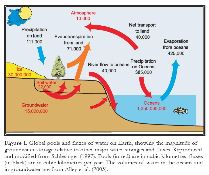
SUMMARY
Development of sustainable groundwater management in Canada requires an integrated approach, including scientific knowledge and managerial and institutional issues. The priority areas that must be considered to assure the sustainable use of groundwater include factors related to groundwater availability and use; these are based on aquifer knowledge (hydrogeological maps, water budgets), as well as social (water demands), political (water laws and regulations), economical, and environmental issues (ecosystem needs). Outside of the Permafrost Shield, groundwater is ubiquitous in most of the landmass of Canada but its distribution (quantity and quality) is only well known in scattered parts of the country. To sustain groundwater supplies in urban and rural areas, the management of groundwater resources should be supported by strong sciencebased programs with scientific knowledge of groundwater availability, vulnerability and sustainability and should be incorporated with water laws and regulations. A case study of an aquifer located in the province of Québec reveals the consequences of the use of groundwater beyond sustainable pumping rates. This case study involved detailed assessment of the aquifer and 3D numerical simulations of the current and predictive scenarios of groundwater withdrawals. A synthesis of the current knowledge of groundwater resources in the world and in Canada as well as the state-ofthe-art of the groundwater sciences, future research activities and other emerging issues with respect to the environment, society and policy, complete this overview.SOMMAIRE
L'établissement d'une gestion viable des eaux souterraines canadiennes appelle une approche intégrée s'appuyant sur des connaissances scientifiques et qui tienne compte des problèmes de mise en œuvre institutionnelles et de gestion. Les champs d'intérêt prioritaires devant retenir l'attention pour espérer atteindre une utilisation viable de l'eau souterraine comprennent des facteurs liés à la disponibilité et à l'utilisation de l'eau souterraine; ces facteurs reposent sur la connaissance des aquifères (cartes hydrogéologiques, budgets hydriques), de même de préoccupations sociales (la demande en eau), politiques (règlements et lois sur l'eau), économiques et environnementales (besoins écosystémiques). En dehors de la zone de pergélisol, l'eau souterraine existe à peu près partout au Canada, mais sa répartition (quantité et qualité) n'est bien connue qu'en certains endroits du pays. Pour assurer la viabilité des sources d'eau souterraine en région urbaines et rurales, la gestion des ressources d'eau souterraine devra s'appuyer sur des connaissances scientifiques solides de la disponibilité, de la vulnérabilité et de la viabilité de l'eau souterraine, et ces connaissances devront se refléter dans les règlements et les lois. L'histoire de cas d'un aquifère du Québec montre bien les conséquences qu'on encoure à surexploiter un aquifère. Cette histoire de cas comprend une étude détaillée de l'aquifère ainsi qu'une simulation numérique 3D de différents scénarios d'exploitation, en leur état actuel et dans l'avenir. Pour compléter cet instantané de la question de l'eau souterraine, le présent article présente une vue synoptique des ressources aquifères du Canada et d'ailleurs sur la planète, de l'état actuel des sciences des eaux souterraines, des prochaines recherches à faire et des problèmes qui pointent à la jonction des questions d'environnement, de société et de réglementation.INTRODUCTION
1 Outside of the polar ice caps, nearly all of the potentially drinkable water on Earth exists as groundwater. New techniques of exploration and production, and an improved understanding of the dynamics of natural groundwater reservoirs, are helping earth scientists find this essential commodity. However, global changes, such as population growth, climate variability, expanding urbanization, often combined with pollution, severely affect water availability and lead to chronic water shortages in a growing number of regions. It is estimated that, within 25 years, two thirds of the world’s inhabitants will live in countries with serious water problems (World Health Organization 2000).
2 Inventive approaches and innovative technologies have to be developed for every possible water resource. It has become evident that groundwater is one of the most important natural resources; it is the main basis of irrigation worldwide, with more than one third of the arable landmass irrigated by groundwater, and the main source of drinking water for a number of countries.
3 Water scarcity is not always the result of a physical lack of water resources; it may also be attributed to inadequate institutional and managerial organization. For instance, according to the 2nd World Water Development Report (UNESCO World Water Assessment Program (WWAP) 2006), an estimated 350 million people in twenty-six countries suffer from severe water scarcity because of problems in water management and governance, although an adequate supply of water is available.
4 In Canada, where water scarcity is not a major issue, institutional, jurisdictional, managerial, and knowledge issues are looming. Water management, governance and jurisdictional factors are some of the main issues that have frustrated a comprehensive national water strategy, in which the sustainable use of groundwater could be guaranteed in a holistic framework by being integrated with surface water, ecosystems, and social and economical issues.
5 This short essay provides an overview of the main groundwater issues in the world and provides a perspective on the Canadian case, in particular, including possible reasons for the incongruity of potential water scarcity in a water-rich country. Groundwater resources are defined and short descriptions of associated, often confusing, terms such as quantity, availability, supply, use and sustainability are provided. The essay focuses on the ‘big picture’ and how Canada fits into it, as well as what must be considered to assure the sustainable use of groundwater in the future.
Figure 1. Global pools and fluxes of water on Earth, showing the magnitude of groundwater storage relative to other major water storages and fluxes. Reproduced and modified from Schlesinger (1997). Pools (in red) are in cubic kilometres, fluxes (in black) are in cubic kilometres per year. The volumes of water in the oceans and in groundwater are from Alley et al. (2005).GROUNDWATER IN THE HYDROLOGIC CYCLE
6 Groundwater is a vital and essential part of the water or hydrologic cycle; it is the water that infiltrates into the ground, filling the voids, cracks and fractures of rocks. The ‘water cycle’, represented in Figure 1 in the form of pools and fluxes, is driven by thermal energy provided by the sun. Water evaporates from the surface of the oceans and continents and is transported through the atmosphere where it stays no longer than eight days, before it precipitates as rain onto the continents and oceans. Once on the ground, precipitation fluxes are redistributed as follows: direct evaporation returns one part of that flux to the atmosphere during and after the rain; and transpiration from vegetation restores part of the water that has infiltrated into the ground during the rain. The sum of both fluxes is called evapotranspiration and it is, by far, the most important flux of the cycle, representing 63% of annual precipitation, on average.
7 On the one hand, infiltration into the ground helps to form the near-surface stock of water needed for evaporation and transpiration in the summer. On the other hand, during the cooler seasons, water infiltrates deeper into the ground, recharging the groundwater contained in the rocks. This deeper infiltration represents, on average, 13% of precipitation.
8 Runoff is another important flux of the hydrologic cycle, representing about 24% of total precipitation. Runoff occurs immediately after the soil can no longer absorb more water. The runoff, in the form of surface water, will eventually form rivers, and has a large variability as a function of the type of soils and the intensity of the rain. It should be noted, however, that a large part of groundwater also ends up in the rivers, forming what is known as the ‘base flow’ of the rivers, that is, a natural flow in the absence of rain (which explains the difference of the fluxes between oceans and land in Figure 1.)
9 Of course, the sum of evapotranspiration, ~ 496 000 km3/year from oceans and land, is equal to the sum of precipitation at the global scale (Fig. 1). On the continents, it rains more than it evaporates, whereas in the oceans, evaporation exceeds rainfall. This difference at the global scale is 40 000 km3/year. Because the water cycle is in equilibrium, this would mean that, every year, the continents send 40 000 km3 of water to the oceans (Tables 1 and 2; World Resources Institute (WRI) 1990).
Table 1. Global values of water fluxes at the scale of the planet (volume in km3/yr 200 m only; it is not all exploitable and and in equivalent water band, mm/year; WRI 1990)

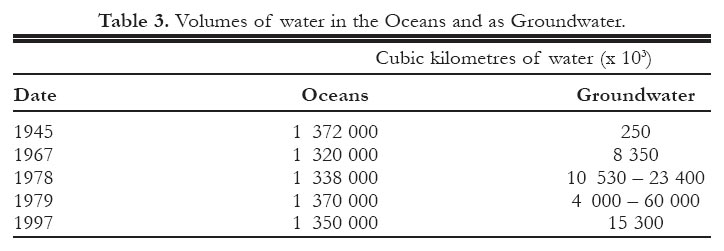
Display large image of Table 1
Table 2. Water fluxes from continents to oceans (in cubic kilometres per year)

Display large image of Table 2
10 In temperate regions, such as in Canada, when rain falls on the ground, one part infiltrates and is essentially used to recharge the ‘soil reservoir’, from where evapotranspiration takes it back to the atmosphere. It is mainly in the cooler seasons, when evaporation is lowest, that water continues downward and reaches the water table. However, this process is complex and varies, depending on the climatic region; permafrost, for instance, has often been considered as simply an impermeable barrier (or aquiclude) to groundwater movement because of the presence of ice-filled pores and fractures. As a consequence, many people consider northern Canada to lack active groundwater flow systems. Although permafrost does have a significant impact on groundwater flow regimes, especially the recharge component, active groundwater flow can be found (to varying degrees) throughout the permafrost region of Canada (pers. comm., Michel 2008).
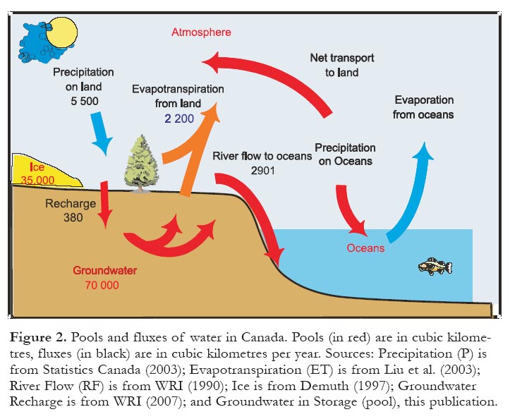
11 And how does Canada fit into the global water-balance picture? Figure 2 presents pools and fluxes of water in Canada. Some 5500 km3 of precipitation (P) falls on Canada every year, mainly in the form of rain and snow. Evapotranspiration (ET) accounts for 40% of P with 2200 km3. River flow (RF), fed by runoff and groundwater (base flow), accounts for 53% of P with 2901 km3. The contribution of runoff to streamflow varies seasonally depending on precipitation, snowmelt, and in some locations, the summer melt of glaciers. Finally, groundwater recharge (I) accounts for 7% of P with 380 km3 (this is estimated from the sum of all base flows of the rivers in Canada). The ice and groundwater pools in Figure 2 are much larger than the yearly precipitation and all river flow combined (Fig. 2). However, the ice pool cannot be used directly, although it serves to maintain river flow and to recharge aquifers in some locations (e.g. the foothills of Alberta).
Figure 2. Pools and fluxes of water in Canada. Pools (in red) are in cubic kilometres, fluxes (in black) are in cubic kilometres per year. Sources: Precipitation (P) is from Statistics Canada (2003); Evapotranspiration (ET) is from Liu et al. (2003); River Flow (RF) is from WRI (1990); Ice is from Demuth (1997); Groundwater Recharge is from WRI (2007); and Groundwater in Storage (pool), this publication.
Display large image of Figure 2
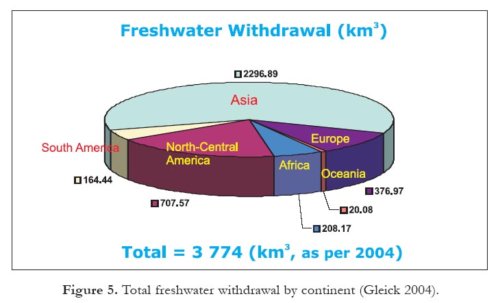
12 The large groundwater ‘pool’ in Canada (estimated to be 70 000 km3; Fig. 2) represents the storage volume of groundwater in aquifers, other than the yearly recharge. The volume in storage was estimated for the upper would be sustainable at the national scale (see sections below).
Groundwater Flow Mechanisms
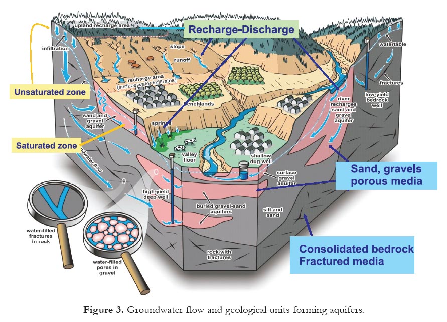
13 Groundwater refers to water that resides within the zone of saturation beneath the Earth’s surface; it is the liquid that completely fills pore and fracture spaces in the subsurface, as shown in Figure 3. Geological units can be defined on the basis of their ability to store and transmit water. An aquifer is a permeable material that can transmit significant quantities of water to a well, springs, or surface-water bodies. An aquifer is not equivalent to a single geologic, lithologic, or stratigraphic unit; two contiguous layers of sand and limestone, for instance, may form a single aquifer. Conversely, a single regional stratigraphic unit may have more than one groundwater flow type, depending on the space and time scales considered. In some cases, we define aquifer systems, which include more than one type of groundwater flow. Aquifers may be composed of: a) unconsolidated sand and/or gravel; (b) permeable consolidated deposits, e.g. sandstone, limestone; or (c) consolidated less-permeable fractured rocks (granitic and metamorphic rocks).
Figure 3. Groundwater flow and geological units forming aquifers.
Display large image of Figure 3
14 Figure 3 shows unsaturated and saturated zones defined by water table or piezometric levels. Generally, groundwater is gravity-driven, in that it moves from areas of high hydraulic head (pressure) to areas of lower hydraulic head (e.g. toward lowland areas in Figure 3). In some exceptional circumstances groundwater can move against gravity, as in the case of density-driven flow (e.g. the occurrence of Dense Nonaqueous Phase Liquids – commonly known as ‘DNAPLs’ – or the interactions between freshwater and saltwater). However, at the regional scale, groundwater always moves from high to low topographic points.
15 Aquifers are recharged in many different ways. In addition to the direct recharge from precipitation (Fig. 3), surface-water bodies can be both sources and sinks for groundwater. For example, the right-hand side of Figure 3 shows groundwater recharged by river water, which later discharges back to the river. Thus, surface watergroundwater interactions are highly dynamic. These interactions do not always take place, and depend on the type of aquifer system, the permeability of rocks, and climate. In Canada, these interactions are extremely important because most of the currently exploited aquifers are shallow aquifers located in unconsolidated Quaternary sediments. In addition, groundwater maintains wetlands and aquatic health by buffering nutrients and temperature fluctuations, especially in riparian and hyporheic zones (Hayashi and Rosenberry 2001).
GROUNDWATER QUANTITY, AVAILABILITY, SUPPLY AND USE, AND SUSTAINABILITY
16 There is very often confusion with some terms as they apply to groundwater resources: quantity vs. availability; availability vs. sustainability; supply vs. use. These terms are clarified here, and also provided are relative quantities of available groundwater resources for the world and for Canada. How much groundwater is there and how much is available for use? In many cases, when ‘the world’s freshwater’ is referred to, it is meant to apply only to ‘surface freshwater’ – the scientific literature does not always explicitly distinguish surface from underground waters. This may be because river runoff (surface water) is the most widely studied water resource, whereas groundwater recharge and storage are least studied. However, to be comprehensive and consistent, articles about the world’s total freshwater should always include surface water and groundwater.
17 The quantity of freshwater resources is fast becoming a big issue in many parts of the world, including Canada. Although essentially a renewable resource, freshwater is being extracted from river basins at rates approaching those at which the supply is renewed, and from some aquifers at rates exceeding natural replacement (i.e. recharge). Many human activities have high water use rates. As societies grow, so have withdrawals of water for agriculture, industry and municipal use. A new element of uncertainty is the potential change in the amount of precipitation, and hence freshwater resources, as a consequence of changes in climate caused by human activities.
Quantities
18 Estimates of the volume of available surface freshwater on the planet vary, depending on the source of information, but the order of magnitude is the same in all cases:
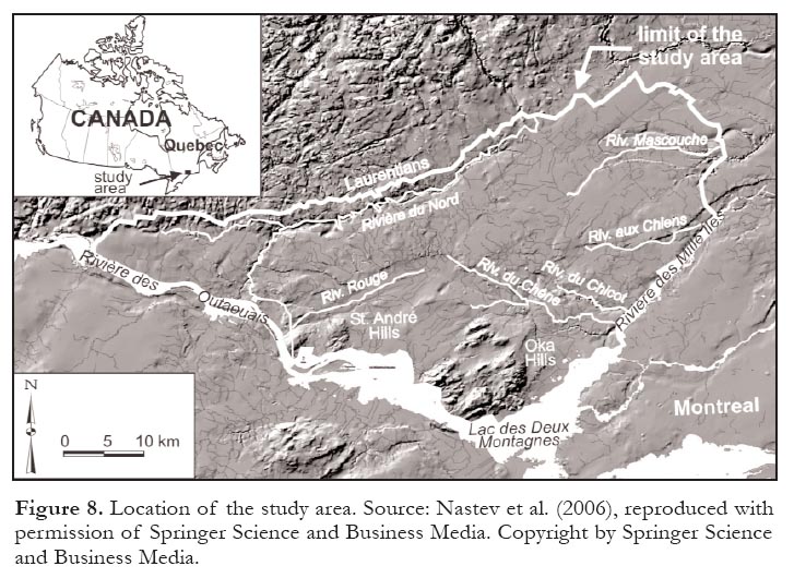
- 135 000 km3 of fresh surface water (total not frozen or underground), including soil and atmospheric moisture, and water contained in biota (Gleick 2000);
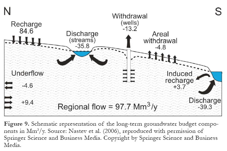
- 104 120 km3, excluding soil, atmospheric and biotic water (Gleick 2000); and
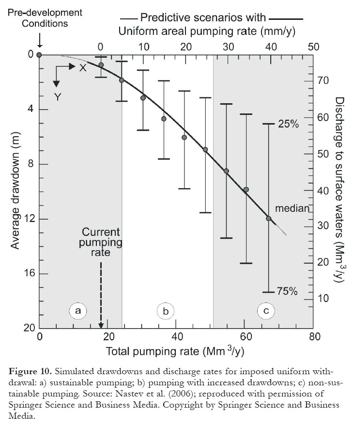
- 109 119 km3, excluding soil, atmospheric and biotic water (UNESCO-WWAP 2006; Shiklomanov and Rodda 2003).
19 However, these numbers represent only a tiny percentage of the total freshwater available in the globe (35 Mkm3). Glaciers, permanent snow cover, ground ice, and permafrost account for 24.3 Mkm3, but this quantity is not readily accessible. The remaining total drinkable freshwater in the world accounts for ca 10.7 Mkm3, of which 10.6 Mkm3 are groundwater and the remainder surface water. Put in percentages, these numbers indicate:
- Glaciers 69.40% (not readily accessible)
- Groundwater 30.28%
- Surface water 0.31% (lakes, rivers and wetlands)
20 Thus, all rivers and all lakes of the world account for less than 1% of the total (usable) freshwater. Interestingly, the volume of the Earth’s oceans has been well known for many years, whereas global estimates for groundwater storage vary by orders of magnitude. Table 3 shows estimates of the volume of water in the oceans and in groundwater between 1945 and 1997; these data come from different studies of the world’s water balance as reported by Alley et al (2005). Today, most workers in the field accept the global volume of groundwater to be 10.6 Mkm3.
21 In part, this variability can be attributed to different considerations of depth and salinity in defining the global groundwater pool. In addition, the variability reflects a lack of knowledge about groundwater compared to other global pools of water. Early estimates of the global groundwater pool greatly underestimated its volume. It was not until after development began in earnest in the mid-twentieth century that an appreciation of the large storage volume of groundwater emerged universally (Alley 2006).
22 To give an approximate idea of the meaning of these volumes of groundwater, the volume of groundwater in one major aquifer can be compared with one of the largest and most well-known surface-water reservoirs of the world, the North American Great Lakes. The Guarani aquifer in South America, shared by Brazil, Argentina, Paraguay and Uruguay (Tujchneider et al. 2003; Vives et al 2000), alone contains 40 000 km3, compared to about 23 000 km3 contained in all five Great Lakes. This single aquifer contains nearly twice as much freshwater as the largest surface freshwater reservoir in the world!
Table 3. Volumes of water in the Oceans and as Groundwater.
Availability
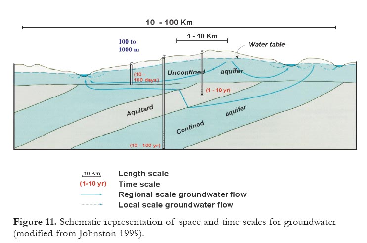
23 Although the quantities of water in a hydrologic system (pools and/or fluxes; Fig. 1) can be measured, computed, or estimated in a straightforward manner, water availability cannot. Like water sustainability, water availability is an elusive and multifaceted concept (Alley et al. 1999). Thus, the challenges of determining groundwater availability are many.
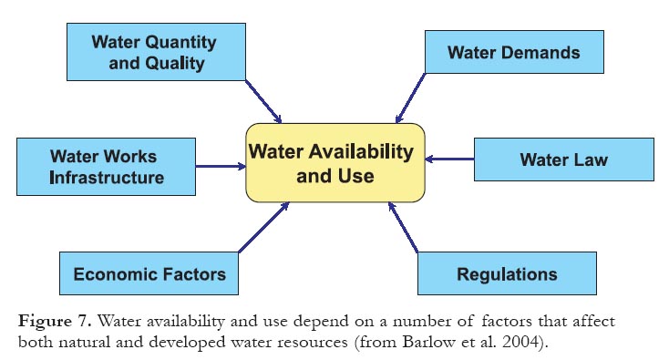
24 Groundwater availability is a function not only of the quantity and quality of the water in an aquifer system but also the physical structures, laws, regulations, and socioeconomic factors that control its demand and use. Physical and chemical characteristics of an aquifer may be used as indicators of groundwater availability; however, at the local level where most decisions are taken, these characteristics must be considered jointly with societal factors that determine actual groundwater availability, and society’s tolerance of the consequences of its use (see Fig. 7, page 79). Societal perspectives and constraints change with time just as the groundwater resource does (Alley and Leaky 2004).
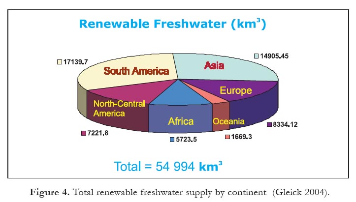
25 This paper proposes to define ‘availability’ as ‘renewable freshwater resources’; i.e. yearly surface water runoff and groundwater recharge, but excluding the volume in storage, as a first approximation for Canadian conditions. Availability might also include volumes of groundwater in storage, but that would be a management decision in cases of temporary water scarcity, e.g. in semi-arid regions). The world’s yearly renewable freshwater resource is estimated to be between 43 000 km3 and 55 000 km3, depending on the source (e.g. Gleick 2004; Shiklomanov 1999; de Marsily 1995).
26 The Pacific Institute for Studies in Development, Environment, and Society, based in Oakland, California (USA), publishes a biennial report on the freshwater resources of the world by country. Figure 4 shows a graphical representation of the world’s renewable freshwater in each continent (Gleick 2004). The data include both renewable fresh surface water and groundwater. The United Nations Food and Agriculture Organization refers to this as "total natural renewable water resources" while the European Union refers to it as "total freshwater resources." In North America, the renewable fresh surface water and groundwater resources for the three NAFTA countries are presented in Table 4.
Supply and Use
27 By supply we mean ‘withdrawal’, or the actual use of freshwater – a widely accepted definition (UNESCO-WWAP 2006). Generally, the world extracts between 4000 km3 and 5000 km3 of total freshwater per year (the sum of surface water and groundwater), depending on the year and on the source of information. Figure 5 shows a graphical representation of the world’s total freshwater withdrawal for each continent (Gleick 2004). In that report, ‘withdrawal’ refers to water taken from a water source for use. It does not refer to water ‘consumed’ in that use. The report further classifies withdrawal based on end use, namely, the domestic, industrial and agricultural sectors.
28 The total water withdrawn in the world has varied substantially over the years and within individual continents. Table 5 shows the total global water used during the twentieth century in the three main sectors. By the beginning of the 21st century, the use of water had increased by factors of 6 to 50 over the preceding hundred-year period. This increase can be explained by increasing population and the ever increasing need for water to sustain growth of communities.
29 If these numbers are compared with those of the global water cycle in Table 2, there would be 40 000 km3 ‘available’, of which 27 000 km3 are the flow of rivers and 10 500 km3 are groundwater base flow. If the 27 000 km3 cannot be contained by the current capacity of the worlds dams (e.g. Canada’s dams have a capacity of 846 km3), then only 10 500 km3 of base flow is left. This means that the total freshwater withdrawn in the world in the year 2000 (5191 km3 in Table 5) is about half of the base flow volume. Thus, the ‘problem’ is not lack of water, but population needs and the location of the water sources – freshwater sources on earth are not evenly distributed, hence there are very waterrich regions and very water-poor regions.
30 The location of the demand centres around the world relative to the available sources is a key issue as well. The demand centres (e.g. urban areas) are mainly responsible for putting pressure on local resources. This is also true for Canada, where most of its water resources are located in more northerly locations, away from most of the population and economic centres where they are most needed. For example, some areas of western Canada are already experiencing periodic water shortages.
Figure 4. Total renewable freshwater supply by continent (Gleick 2004).
Display large image of Figure 4
Table 4. Renewable fresh surface and groundwater resources in the NAFTA countries. The data represent average values compiled by Gleick (2004) for different years; the actual annual renewable resource will vary from year to year.

Display large image of Table 4
Display large image of Figure 5
Table 5. Water consumption in the world during the 20th Century, in km3/y (de Marsily 2000)

Display large image of Table 5
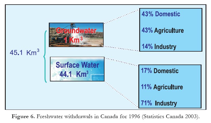
31 Compared to the world, the use of freshwater in Canada seems negligible. The total freshwater withdrawals for Canada are shown in Figure 6, broken down by source (surface water and groundwater) and by sectors. The total volume withdrawn by all sectors is about 45 km3 per year, which is small compared to the total yearly 'renewable' freshwater in Canada (2901 km3). However, because of geography, population distribution, and other factors, these numbers should be treated with caution. Most of the runoff from Canadian rivers (60%) drains to the north and is 'lost' into oceans, while most of the population (85%) lives along the southern border with the United States. Furthermore, given the present infrastructure, Canada does not have the installed capacity to capture runoff. That is one of the reasons why the use of groundwater for domestic purposes has increased 200% in three decades — from 10% in the late 1960s to 30% in the late 1990s. The total groundwater use in Canada is ~1000 Mm3 per year (Statistics Canada 2003), mostly withdrawn for domestic and agricultural purposes, as shown in Figure 6. Nearly 30% of the population uses groundwater for domestic drinking water. And the trends indicate that groundwater use will continue to increase at a rate faster than surface water use in the future. Possible explanations for this are, a) abundant freshwater at shallow depths; b) generally good water quality in aquifers, and c) acquisition facilities for groundwater are faster and cheaper to build and maintain. However, the big disadvantage, compared to surface water, is that there is inadequate knowledge of groundwater as a resource at regional scales. It is used and developed without assessing its dynamics, recharge and discharge, interactions with surface water and ecosystems, volume in storage, vulnerability, and sustainable yields. At the local level (well-scale), where groundwater is critical for economic development, the resource is studied in more detail and it is better understood.
Figure 6. Freshwater withdrawals in Canada for 1996 (Statistics Canada 2003).Figure 7. Water availability and use depend on a number of factors that affect both natural and developed water resources (from Barlow et al. 2004).Sustainability
32 Water availability and use are closely related to water sustainability, which can be thought of as an approach for managing water resources. As seen in the previous sections, Canada does not have a problem of water scarcity, and water is abundant. But Canada has looming water-related issues related to demand, availability, geographical location, and so on. So the overarching question is: what is the availability of water resources (surface and underground) in the country and how does this availability relate to expected demand, sources, and geographical locations?
33 Water availability and use depend on a number of factors that affect both the natural (or raw) resource and the developed resource (that part of the natural resource that is reliably available for use). Figure 7 shows these factors, including the total flow and quality of water within a basin (and/or aquifer); water supply demands; and the structures, laws, regulations, and economic factors that control water uses (Barlow et al. 2004). As seen in Figure 7, future plans for assessing water availability and sustainable use will necessarily need to take into account other types of physical, social, economic, and environmental data.
34 Sustainability of groundwater resources cannot be defined as an absolute concept. It is a relative concept and it has many variations. For the purposes of this essay, the definition proposed by Barlow et al. (2004) is adopted, although this definition encompasses all types of water resources: "Water resources sustainability is defined in a broad context [as exploitation of water] in a manner that can be maintained for an indefinite time without causing unacceptable environmental, economic, or social consequences."
35 Sustainable use of groundwater resources demands knowledge of recharge and discharge, fluxes for which adequate measurement techniques are not available in many instances. The sustainability of groundwater resources requires a detailed knowledge of the components of the water balance of a given aquifer, or any other management unit where groundwater is withdrawn by humans and/or ecosystems. The current practice for evaluating those components, is through the use of calibrated numerical models. This approach, although acceptable as an initial step, has a few drawbacks, and if these are not addressed properly, the model results may be finalized despite many uncertainties. The main drawbacks are related to the components included in the model; e.g. the hydrogeological models do not include all the components shown in Figure 7. Furthermore, the models are rarely linked to a monitoring program, which is necessary to update and validate the models.
36 With a few exceptions, our knowledge of groundwater components in the water cycles of Canada, from local to regional scales, is not adequate or not sufficiently comprehensive. There are barely enough data to determine the amounts of renewable or stored groundwater for key aquifers across Canada. To overcome this deficit, future studies in Canada will have to develop data and information with enhanced resolution and increased precision compared to data collected in the past. Techniques can be borrowed from other disciplines and adapted to provide new methods for measuring key variables. Data from new sensors and from existing networks will have to be integrated and new observation networks will have to be established. Temporal and spatial variability will need to be measured to produce high-quality records that incorporate long-term fluctuations. Some of the sensors used in remotesensing technologies might be the future solution for covering large regions in a timely manner (see section on Future Research Activities, page 84). All of these measurements will have to be put within the context of conceptual models and associated numerical models, which could be used, in turn, as management tools for reliable predictions.
37 In brief, the (minimum) elements needed in any assessment of groundwater sustainability include, a) for pre-development (steady-state) conditions:
- Geological maps that illustrate hydrostratigraphy,
- Digital elevation model maps,
- An assessment of natural boundary conditions
- Recharge data (from precipitation or induced surface water bodies),
- Discharge data (to evapotranspiration and to surface water bodies),
- Lumped regionalized parameters (non-discretized combination of aquifer parameters),
- Knowledge of hydraulic diffusivity per area (ratio of aquifer transmissivity over aquifer storativity),
- Water budgets (natural and disturbed),
- An inventory of surface water bodies, and
- Data on natural water quality; and, b) for development (transient) conditions: all of the above plus pumping records.
38 In addition to the physical, geological and chemical parameters inherent in the above list of elements, a full assessment of groundwater sustainability must include the factors indicated in Figure 7 for water availability and use.
A Case Study
39 An example of regional-scale aquifer characterization, including sustainability assessment, is a study conducted in southern Québec that used a 3D numerical model (Nastev et al. 2006). This assessment was performed under the auspices of the national groundwater inventory program of the Geological Survey of Canada (Rivera 2003). Figure 8 shows the location of the study area in the St. Lawrence Lowlands of southwestern Québec. The study area comprises 1500 km2 underlain mainly by a sedimentary bedrock aquifer; the population in this area is heavily dependent on groundwater. The regional sustainable use of groundwater was defined with a 3D numerical model simulating uniform withdrawal scenarios.
Figure 8. Location of the study area. Source: Nastev et al. (2006), reproduced with permission of Springer Science and Business Media. Copyright by Springer Science and Business Media.
Display large image of Figure 8
40 The simulated groundwater balance components are schematically presented in Figure 9. The detailed quantitative analysis of pools and fluxes in the aquifer showed steady-state conditions overall, but also highlighted the importance of groundwater in maintaining discharge in streams. The current groundwater use in the region amounts to 18% of the yearly recharge to the aquifer, and less than 1% of the groundwater present in storage.
41 The results of the simulated predictive scenarios that assess the sustainability of aquifer use show the cause-effect relationship between withdrawal rate and simulated drawdowns for the regional aquifers (Fig. 10). The results indicate that simulated drawdowns increase faster with higher withdrawal rates. As the recharge component remains constant, the applied uniform withdrawal rate is accounted for mainly by capturing the groundwater discharge. The computed drawdown is not a random variable but is rather influenced by the simulated hydrogeologic conditions and the density of the element nodes in the 3D model. In this case, the Gaussian distribution is no longer valid. The regional drawdown values are thus estimated with percentiles. The median represents the average estimate; 50% of all drawdown values are less than the median and 50% are greater. The difference between the 25th and 75th percentile indicates the range within which 50% of the drawdown values lie, whereas 25% are left outside on each side of this range.
Figure 9. Schematic representation of the long-term groundwater budget components in Mm3/y. Source: Nastev et al. (2006), reproduced with permission of Springer Science and Business Media. Copyright by Springer Science and Business Media.
Display large image of Figure 9
Display large image of Figure 10
42 Three distinct zones are evident (Fig. 10). The first zone (a) covers the range of sustainable pumping rates of up to 24 Mm3/y. In this zone, the simulated drawdowns are relatively low (<2 m), and increase slowly as pumping rates increase. The second zone (b) is characterized by increased withdrawal rates. It starts from the inflection point of the fitted drawdown/pumping curve, and extends to the point where the pumping rate equals the discharge rate. Although the average drawdowns may not seem to be very high under current conditions of groundwater use in southwestern Québec, they are considered high because most of the pumping wells are shallow wells that intercept only the upper portion of the regional fractured aquifers. The third zone (c) displays non-sustainable pumping rates larger than 51 Mm3/y, i.e. the withdrawal rate would exceed the natural discharge rate to streams and rivers, which is a function of the natural recharge rate under given climate conditions. Therefore a pumping rate that exceeded 51 Mm3/y would reduce the discharge to surface water by 20% to 40% and could eventually lead to the drying of some streams.
43 This case study does not include the factors illustrated in Figure 7. The water demands, and the structures, laws, regulations, and economic factors that control groundwater uses and users in the region would have to be determined by water resource managers. In this way, managers will be able to make informed decisions using the results of this study in conjunction with other socio-economic factors.
REVIEW OF CURRENT STATE OF THE ART
Science vs. Knowledge
44 Hydrogeology has become a relatively mature science that enables us to understand much about the physics and chemistry of groundwater flow; despite this, the groundwater resources of Canada are still not well understood. It can be argued that ‘we know a lot about groundwater’, but most would agree that there are significant information gaps about the availability and sustainability of groundwater in most regions. These gaps include the need to map aquifers, to better understand the amount of groundwater being stored and used, and to improve our knowledge about renewal rates. Furthermore, there is a need to improve our understanding of the role of groundwater and its interactions with other components in the complex water cycle.
The Consequences of Limited Knowledge
45 Scientific knowledge is necessary for the sustainable management of groundwater resources; knowledge and information are the backbone of any water management scenario. Thus, the question should be raised: how can water resources be managed appropriately when knowledge is deficient?
46 As a country, and for the purposes of resource management, Canada still lacks crucial knowledge about its groundwater resources in many regions. Canada lacks a national, longterm monitoring plan for groundwater quantity and quality. We rank second in the world for freshwater availability, second in per-capita water use; third in annual renewable freshwater availability; fifteenth in infrastructure for longterm groundwater monitoring (OECD countries); and among the last countries on the list in terms of installed water meters and fees for water usage.
47 A very important piece of information for groundwater management in the decision-making process, for instance, is the availability of detailed information about groundwater use. Although some federal and provincial databases on groundwater use exist (e.g. Environment Canada’s Municipal Water Use Database, or MUD), these are not sufficiently detailed because of the lack of water metering and monitoring across the country. For instance, aquifer models that are designed for managers as tools to be used in their decision making cannot be fully calibrated, validated, or applied in simulations involving availability, supply and demand, because of a lack of knowledge about usage and about the aquifer itself.
Figure 11. Schematic representation of space and time scales for groundwater (modified from Johnston 1999).
Display large image of Figure 11
48 The country faces international pressure from foreign governments for water exports, and its freshwater resources – rivers, lakes, and aquifers – are sensitive to climate change and variability. Thus, very detailed scientific knowledge on these is essential to be better positioned for any future bi- or multilateral negotiations with respect to water exports. The country requires easily accessible, standardized groundwater databases, as well as better linkages and communication between water scientists and water managers.
49 The inventory of Canadian groundwater resources is sparse and often inadequate. Coverage is variable among jurisdictions, and what has been accomplished has not been done to consistent standards. Initiatives to accelerate and acquire the necessary knowledge are often deferred, likely because groundwater is out of view, misinterpreted, complex and expensive to study. Nevertheless, new initiatives (see page 85) are underway, at both provincial and federal levels, as issues such as availability, sustainability etc. accumulate. In brief, it is critical for Canada to acquire scientific knowledge of the status of our groundwater resources; a periodic inventory of the nation’s surface water, groundwater and water quality will go a long way toward implementation of best management practices based on informed decisions on sustainable management of groundwater resources.
Issues of Scale: Time and Space
50 One of the problems linked to the misunderstanding of, and indifference toward, groundwater is the issue of scale. Groundwater is often misinterpreted because of the lack of knowledge of scales of time and space associated with the response of groundwater flow to natural and anthropogenic stresses.
51 Groundwater flow systems occur at different scales both in space and in time. In hydrogeology, three spatial scales and two temporal scales are distinguished (Rivera 2004). The spatial scales comprise, a) the regional scale (greater than 1000 km2; generally in steady-state conditions), b) the local scale (typically hundreds of square kilometres; may be in both steady-state and transient conditions), and c) the site scale (generally less than 100 km2; typically in transient conditions). The temporal scales refer to, a) steady-state conditions of hydrodynamic equilibrium, and b) transient conditions in which the system is under stress (e.g. by pumping).
52 Although the absolute areas for each spatial scale are somewhat arbitrary, they are nevertheless indicative of important differences as observed in aquifers studied in Canada (Rivera 2005). Figure 11 is a schematic representation of these scales. In general, aquifers are heterogeneous in nature and their hydraulic/hydrologic behaviour (flow rates, flow volumes, mass and heat transport) is partly dictated by this heterogeneity. Site-scale shallow aquifers have a relatively rapid response to applied stresses, and the effect of these stresses is limited in time and space (hundreds of metres to a few kilometres, and tens to hundreds of days). Aquifers at the local to regional scales have a much broader and longer term response; the effects are spread out over tens of kilometres, and tens to hundreds of years. This is even more striking when an aquifer system contains aquitards (impermeable layers; Fig 11). This situation is not uncommon in Canada, as has been observed in the prairies (Maathuis and Thorleifson 2000).
53 The scale issue is not trivial and should not be ignored. For instance, a question a water resource manager or a community might ask is: "How quickly would we expect to detect a change in groundwater level during a drought?" or "If nutrient source controls were implemented, how quickly would we be able to see a change in the nitrate concentration in the aquifer?" How quickly an aquifer responds to a change in hydraulic stress (e.g. increase or decrease in the amount of water input or increase in well pumping) or chemical stress (e.g. decrease in nitrogen loading) can be estimated by calculating an aquifer’s hydraulic or chemical response time.
54 The concept of response time in assessing how an aquifer would respond to changes in water or chemical inputs and outputs is important to understand. The hydraulic response time can be calculated, knowing the key aquifer parameters and the relative permeability of the adjacent rocks. Thus, to reiterate, knowledge is crucial to understanding and managing this resource.
Management Issues
55 Society views groundwater in many different ways. Perhaps as a result of complacency, lack of awareness, or lack of information, in many cases there is no economic value associated with groundwater, unless it is bottled and sold. There is no incentive to conserve groundwater, unless shortages are encountered. There is no interest in the natural quality of groundwater, unless someone, contaminated by E. coli, is taken to a hospital. There is no interest in knowing how groundwater moves underground, unless a nearby oil refinery begins using the same aquifer. And very often there is no interest in knowing how much groundwater is available, unless one has to drill deeper and deeper, or over-pumping of wells begins to cause rivers to dry up.
56 So, ‘drivers’ and ‘motivations’ are needed to invest in acquiring knowledge. The problem is that when and if the decision is finally made to acquire knowledge, it might be too late, especially when dealing with groundwater, for groundwater has its own time scale. For example, groundwater has a good natural quality almost everywhere. Most causes of poor groundwater quality are due to human activities that modify the aquifer. Over the years, it has become apparent that anthropogenic effects may appear slowly, after a long delay; similarly, the aquifer may not recover to its original (natural) state for a long time (Custodio 2007). Because the turnover time of water in the groundwater regime is often measured in years to many hundreds of years, groundwater quality recovery after diffuse or point contamination processes may be very slow; and although some artificial remediation of contaminated sites is possible, it is often inefficient and expensive. So what has been learnt from the 70s, 80s and early 90s, when millions to hundreds of millions were spent on cleaning up contaminated aquifers?
57 Groundwater contamination control and effective aquifer protection are major challenges for science, technology and natural-resources management. Although clear advances have been made, further research is needed, jointly with increased social awareness of the problem, cooperative action between institutions and stakeholders, and the integrated management of natural resources. Taking into account aquifer characteristics and the long periods of time involved in groundwater flow and mass transport, as well as the large costs of redressing a given situation, aquifer protection should be a priority for groundwater management. This principle is widely accepted by professionals, managers and planners who have a good understanding of groundwater, but is largely ignored by many policy makers and groundwater users who do not have a sound knowledge of groundwater characteristics and behaviour (Custodio 2007).
58 Thus, a good understanding of processes is needed to assess groundwater development and the effects of land use on aquifers, which, in turn, has to rely on adequate monitoring of aquifers and land-use activities. It follows that management of groundwater resources, which includes laws and regulations, should be supported by a strong science-based program.
Economic Issues
59 Water shortages tend to be local. That is true overseas as well as here in Canada. But the overall trend is a deteriorating water supply, especially overseas. It is interesting to note how reactions to increased prices in commodities such as oil, gas and food stand in marked contrast to attitudes toward water, even when it is in short supply or its quality is diminished.
60 A prospective analysis of water demand and water resources, both in Canada and worldwide, needs to be developed. This should clearly include groundwater resources as an integrated part of the resource availability, and should include the needs of ecosystems as part of overall water demand. As water is not a commodity (at least it is not considered as such in Canada), but a natural asset for the benefit of all, a long-term investment in water is warranted.
61 Because water, and groundwater in particular, has moved high up on the list of priorities of the Canadian government, there is a greater awarness and appreciation of the value of groundwater. Currently, both provincial and federal jurisdictions are making efforts to contribute to our understanding and assessment of groundwater resources. However, little has been done to quantitatively estimate the enormous economic value of groundwater withdrawals in Canada; thus, Canada could benefit from the development of analytical techniques to estimate this value. Some of these initiatives could include, a) enhanced economic research into the forces shaping groundwater demand and the valuation of the benefits derived from groundwater use, and b) evaluation of alternative regulatory approaches for governing groundwater use. These approaches may include more sophisticated property rights regimes, markets for groundwater (and surface water) use, and conservation-orientated pricing of groundwater use.
62 To paraphrase Samuel Johnson: "Water, like gold and diamonds, will one day owe its value only to its scarcity".
Emerging Interactions with Environment, Society and Policy
63 Current international practices for water governance use the concept of a trialogue. A trialogue is a conversation or discussion in which three people or groups participate. In the case of water governance, a trialogue includes Government, Society and Science (Turton et al. 2007). This water trialogue handles the basic elements of governance, with a specific focus on Integrated Water Resources Management (IWRM) issues.
64 The concept of governance, and especially ‘good governance’, is pivotal to the achievement of IWRM. The definition of IWRM as "a process which promotes the co-ordinated development and management of water, land and related resources, in order to maximize the resultant economic and social welfare in an equitable manner without compromising the sustainability of vital ecosystems" clearly expresses that governance is a fundamental element in the process.
65 Relations among the three groups of ‘actors’ in the water governance trialogue are based on communication and feedback, and the efficiency of these relations is a function of the interface quality among the trialogue actors. There are three main interfaces. First, the government-society interface determines the needs and requirements of society, the legitimacy of the political process, and the receptiveness of government to new ideas from civil society and the corporate world. This interface also represents the degree to which government satisfies the needs of society. Second, the government-science interface determines the extent to which scientific knowledge informs the decision-making processes that are a principal function of government. Finally, the science-society interface can be thought of as science in the service of society. It consists of a number of elements, including the ways that scientific knowledge is disseminated to the public.
66 And in terms of water, who drives who in Canada? Is government driving the country? Is society driving the country or government? And where does science come in? Is science setting the basis for good government, or is society doing so? Are scientists being listened to? Are politicians listening to citizens? Are they listening to scientists? Does society care about science? Is there a well-established dialogue between politicians and citizens and between politicians and scientists? Is there a dialogue between scientists and citizens? Does a trialogue exist in Canada where government, society and science converge? These and many other questions relative to a water trialogue are currently being discussed by governments, users, institutions and ordinary citizens across Canada; but they are not yet resolved.
What is Science Doing?
67 Meetings and symposia, government reports, professional articles and books on groundwater abound; it is a subject of great interest in Canada and abroad where almost everything has been said and anticipated. However, there is still no clear consensus on the path forward for water-resources management; in particular, there is no clear action plan at the national level aimed at dealing with the many water-related issues and solving water problems in a holistic manner.
68 Nonetheless, scientific knowledge of groundwater resources continues to advance in Canada, and science and technology are becoming strong drivers for sound water-resources management and water policies. Canadian scientists are not only doing the science, but they are participating and getting involved in public outreach and education. It has become clear that there is a need to acquire competencies, beyond those found in the earth sciences, to promote the groundwater file in a clear and transparent manner in the national (and international) arenas. In brief, the need for ‘corporate hydrogeologists’, has become a reality as suggested by Ragone (2002).
69 In the last seven years, investment in groundwater studies by provincial and federal governments and universities has increased. Of particular note is the creation of a research network of universities (the Canadian Water Network, or CWN) supported by the National Sciences and Engineering Research Council of Canada (NSERC). The CWN was created to identify and solve the main problems related to good water supply quality, and to lay the basis of a national vision for management and effective use of our water resources. As such, the CWN is addressing current and emerging water issues and transforming research into economic and social benefits for the nation.
70 In addition to universities, various departments have launched projects or national programs to fill in groundwater knowledge gaps across Canada. The Geological Survey of Canada, for instance, initiated a national groundwater program in 2003, to inventory the groundwater resources of Canada through the systematic characterization and detailed assessment of key aquifers, as well as the creation of a standardized national groundwater database. Since its beginning, the work of the GSC has been enhanced by strong cooperation with several provincial governments.
71 Other important national initiatives are: the national Water Availability Indicators project of Environment Canada; the National Water Atlas initiative, which is a joint project co-led by Agriculture and Agri-Food Canada (AAFC), Environment Canada, Statistics Canada and Natural Resources Canada; the National Land and Water Information System by AAFC, and others.
FUTURE RESEARCH ACTIVITIES
72 Future research activities needed to fill in the gaps in knowledge and to acquire data and information on groundwater resources in Canada must go beyond the domain of earth sciences. They will need to touch on aerospace sciences (remote sensing), information technology, social sciences, and environmental sciences. Even more importantly, one must go beyond just publishing articles in technical journals and increase the communication in, and outside the earth sciences. One must go outside of the comfortable area of talking with our fellow professionals in geology and engineering.
73 The use of multiple methods and datasets must be emphasized when mapping and assessing aquifers. Given the complexity and 3D nature of aquifers, all studies of groundwater resources must utilize computer models, integrated and strongly linked to good monitoring programs. Integration of geophysical and geological data, combined with accurate flow and transport measurements adapted to the hydrogeological context, will contribute significantly to aquifer characterization. With this approach, a process can be developed to allow for 3D characterization of the hydrogeological properties of aquifers from a variety of different sources.
74 Remote sensing using satellite observations is a powerful means of mapping aquifers and assessing groundwater resources. Although still in its infancy, earth observation applications and products are already helping aquifer mapping efforts and are adding value to aquifer assessments. For instance, land-use and land-cover mapping, leaf area index and soil property characterization are basic data required for the estimation of waterbalance parameters used in the modelling of recharge to aquifers.
75 Another area of research with great promise in the coming years is the mapping of groundwater resource variability from the Gravity Recovery and Climate Experiment (GRACE) satellite data. The GRACE satellites were launched on March 2002, and will operate until about 2011. One of the key mission objectives is to monitor terrestrial water-storage changes. During the past five years, extensive studies have aimed to extract evidence of changes in water-storage from GRACE gravity data at the finest possible resolution in time and space. The Groundwater Mapping Program of NRCan has initiated an experimental project to map the temporal variability of groundwater resources in major water basins across Canada, using GRACE data and auxiliary measurements, e.g. snow, ice, surface water and soil moisture. These maps will provide a new, comprehensive, national view of groundwater that complements the targeted in-situ data and the microwave remotely sensed data now available. After validation of GRACE data and the development of processing methods, a series of maps will be produced to show groundwater variability in major Canadian water basins (Huang and Halpenny 2007).
SUMMARY AND CONCLUSIONS
76 Although not as visible as surface water, groundwater is ubiquitous in the global landmass and is contained in the pore spaces of earth materials of all types (aquifers). The science of groundwater hydrogeology has rapidly developed over the last 35 years, and has contributed to the well-being and development of the human population in all parts of the globe (Burke and Moench 2000).
77 Canada is not a uniformly water-rich country, and difficulties can be foreseen because the inventory of groundwater resources is deficient. Groundwater mapping is variable across jurisdictions, and what has been accomplished has not been done to consistent standards. The groundwater sciences are mature and the technologies and methodologies employed to investigate groundwater abound, but the knowledge of the nature and distribution of this resource in Canada is incomplete. Initiatives to accelerate the acquisition of necessary knowledge are deferred because groundwater is hidden, complex, and expensive to study. Nonetheless, new initiatives are underway that will contribute to an enhanced understanding of this precious resource both at the provincial and federal levels.
78 Globally, there is an increasing demand for groundwater resources as surface water supplies become overexploited or contaminated. Groundwater resources need to be considered as a vital component of any policy discussion pertaining to water; groundwater not only constitutes about a third of Canada’s drinking water supply, but is also key to the health and long-term sustainability of ecosystems. Localscale studies need to be continued, but there is also a need to consider groundwater at a provincial/international scale, because the boundaries of groundwater systems do not normally coincide with political boundaries.
79 Federal and provincial initiatives have studied important aquifers across Canada, and there are many municipal studies that provide important insight into the regional scale, but it is still too early to frame a complete portrait of groundwater resources at the national scale. Highlights of these studies indicate that:
- Pre-development conditions (i.e. in hydrodynamic equilibrium) prevail almost everywhere, but some areas show threats to water quantity and quality,
- The regional-scale aquifers studied are mostly exploited at shallow depths,
- The most important knowledge gaps are geological frameworks (e.g. lack of Quaternary maps and buried valleys); surface water/groundwater interactions; groundwater use (supply) volumes; and sustainability and vulnerability of regional aquifers,
- An inventory of groundwater resources is being slowly assembled,
- Cooperation between federal and provincial governments and universities is increasing, and
- Management of groundwater resources, including laws and regulations, is still not supported by strong science-based programs.
80 Groundwater resource sustainability is not simply a scientific concept, but rather a perspective that can frame scientific analysis. The evolving concept of sustainability presents a challenge to hydrogeologists to translate complex, and sometimes unfamiliar, socioeconomic and political questions into technical questions that can be quantified systematically. Groundwater scientists should contribute to sustainable groundwater resource management by presenting the longer-term implications of groundwater development as an integral part of their analysis.
81 The challenges awaiting groundwater scientists are formidable, but the rewards associated with gaining improved understanding are obvious. So are the consequences for failing to do so.
ACKNOWLEDGEMENTS
This paper is an Earth Sciences Sector Contribution number 20080374. The comments by Alan Kohut, Jim Teller, and a third anonymous reviewer significantly improved the original version of this manuscript and are highly appreciated.REFERENCES
Alley, W.M., 2006, Tracking U.S. groundwater: Reserves for the future?: Environment: Science and Policy for Sustainable Development, v. 48, no. 3, p. 10-25.
Alley, W.M., and Leaky, S.A., 2004, The journey from safe yield to sustainability: Ground Water, v. 42, no. 1, p. 12-16.
Alley, W.M., Reilly T.E., and Franke, O.L., 1999, Sustainability of ground-water resources: United States Geological Survey, Circular 1186, 79 p.
Alley, W.M., LaBaugh, J.W., and Reilly T.E., 2005, Groundwater as an element in the hydrological cycle, in Anderson, M., ed., The Encyclopaedia of Hydrological Sciences: John Wiley and Sons Ltd., p. 2215-2228.
Barlow, P.M., Alley, W.M., and Myers, D.N., 2004, Hydrologic aspects of water sustainability and their relation to a national assessment of water availability and use: University Council on Water Resources, USA, Water Resources Update, v. 127, p. 76-86.
Burke, J.J., and Moench, M.H., 2000, Groundwater and Society, Resources, Tensions and Opportunities: United Nations Department of Economic and Social Affairs, New York, 170 p.
Custodio, E., 2007, Groundwater protection and contamination: The Global Importance of Groundwater in the 21st Century: Proceedings of the International Symposium on Groundwater Sustainability, Alicante, Spain, p. 219-231.
de Marsily, G., 1995, L’Eau : Flammarion, Paris, 127 p.
de Marsily, G., 2000, Le cycle de l’eau et l’adéquation besoin-ressources au 21ème siècle: Canal U-Education, France, July 18, 2000.
Demuth, M.N., 1997, A discussion of challenges facing freshwater monitoring in Canada: Canadian Water Resources Journal, v. 22, no.1, p. 89-92.
Gleick, P.H., 2000, The World’s Water 2000-2001: Pacific Institute for Studies in Development, Environment, and Society, Island Press, Washington, DC.
Gleick, P. H., 2004, The World’s Water 2004-2005: Pacific Institute for Studies in Development, Environment, and Society, Island Press, Washington DC.
Hayashi, M., and Rosenberry, D.O., 2001, Effects of groundwater exchange on the hydrology and ecology of surface waters: Journal of Groundwater Hydrology, v. 43, p. 327-341.
Huang, J., and Halpenny, J., 2007, Estimating variation of groundwater storage within the Great Lakes Water Basin from GRACE, soil moisture and lake levels: Joint International GSTM and DFG SPP Symposium, October 1517, 2007, GFZ Potsdam, Germany, 15 p. [http://www.dgfi.badw.de/ typo3_mt/fileadmin/20071015-17Potsdam/di_0830_08_huang.pdf]
Johnston, R.H., 1999, Hydrologic budgets of regional aquifer systems of the United States for predevelopment conditions: United States Geological Survey, Professional Paper 1425, 34 p.
Liu, J., Chen, J.M., and Cihlar, J., 2003, Mapping evapotranspiration based on remote sensing: An application to Canada’s landmass: Water Resources Research, v. 39, no. 7, p. 1189.
Maathuis, H., and Thorleifson, L.H., 2000, Potential impact of climate change on Prairie groundwater supplies: Review of current knowledge: Saskatchewan Research Council, Publication No. 11304-2E00, 43 p.
Nastev, M., Lefebvre, R., Rivera, A., and Martel, R., 2006, Quantitative assessment of regional rock aquifers, southwestern Quebec, Canada: Water Resources Management, v. 20, p. 1-18.
Ragone, S.E., 2002, Corporate Hydrology: Profit by growth or by acquisition? (Editorial): Ground Water, v. 40, no. 5.
Rivera, A., 2003, National Groundwater Inventory, Groundwater Mapping Program: Natural Resources Canada, Geological Survey of Canada, [http://ess.nrcan.gc.ca/2002_2006/gw p/index_e.php]; [http://ess.nrcan.gc.ca/gmces/proj1_e.php].
Rivera A., 2004, On the inventory of the groundwater resources of Canada and the concept of sustainable groundwater development: Proceedings, 5th Joint International Association of Hydrogeologists (Canadian National Chapter)-Canadian Geotechnical Society Conference, 24–27 October 2004, Québec City, p. 2-9.
Rivera, A., 2005, How well do we understand groundwater in Canada? A science case study, in Nowlan, L., ed., Buried Treasure – Groundwater Permitting and Pricing in Canada: The Walter and Duncan Gordon Foundation, Toronto, Canada, p. 4-12.
Schlesinger, W.H., 1997, Biogeochemistry: An Analysis of Global Change: Academic Press, San Diego, CA, 2 nd Edition, 443 p.
Shiklomanov, I.A., 1999, World Water Resources and Their Use, A joint [Russian] State Hydrological Insti-tute/UNESCO product, UNESCO International Hydrological Programme, [http://webworld.unesco.org/water/ihp/db/shiklomanov].
Shiklomanov, I.A., and Rodda, J.C., 2003, World Water Resources at the Beginning of the 21st Century: Cambridge University Press, 452 p.
Statistics Canada, 2003, Human Activities and the Environment: Annual Statistics 2003. Statistics Canada, Ottawa, November 2003, http://www.statcan.ca/english/freepub/16-201-XIE/2007000/part1.htm.
Tujchneider, O., Perez, M., Paris, M., and D’Elia, M., 2003, The Guarani aquifer system: A resource shared by four countries. Geological Society of America Annual Meeting, Seattle, November 2-5, 2003, Paper No. 6711, Geological Society of America Abstracts with Programs, v. 35, no. 6, p. 198
Turton, A.R., Hattingh, H.J., Maree, G.A., Roux, D.J., Claessen, M., and Strydon, W.F., eds, 2007, Governance as a Trialogue: Government–Society–Science in Transition: Water Resources Development and Management Series, Springer-Verlag, 354 p.
UNESCO World Water Assessment Program, 2006, Water: A Shared Responsibility: The Second United Nations World Water Development Report, 584 p.
Vives, L., Campos, H., Candela, L., and Guarracino, L., 2000, Premodelo de flujo del Acuífero Guaraní: Proceedings of the 1st Joint World Congress on Groundwater, Fortaleza, Brasil, 19 p.
World Health Organization (WHO), 2000, Global Water Supply and Sanitation Assessment: 2000 Report, 80 p.
World Resources Institute (WRI), 1990, World Resources 1990-1991: Oxford University Press, New York, 384 p.
World Resources Institute (WRI), 2007, Internal Renewable Water Resources (IRWR): Groundwater recharge, volume, [http://earthtrends.wri.org/searchable_db/index.php?theme=2]
