Great Mining Camps of Canada 2.
The History and Geology of the Anyox Copper Camp, British Columbia
Ross Sherlock1Gold Field Exploration
ross.sherlock@gfepl.com
Julie Domvile2julie_domvile@shaw.ca
Submitted January 2008. Accepted as revised, May 2008
SUMMARY
The Anyox copper mining camp played a key role in the early development of northwestern British Columbia. It was discovered in 1889 and through persistence and belief in the project (a common theme in modern exploration), it was explored and brought into production in 1914 by Granby Consolidated Mining, Smelting and Power Co., Ltd. A large, modern and self-sufficient town was built around the mine to accommodate, and care for, a large work force and their families, which reached a population of over 2500. Two electrical generating powerhouses were built, one coal fired and the other hydroelectric, to operate the mine, mill and smelter complex that produced blister copper (~99% purity). Over 21.73 million tonnes of copper ore, at an average recovered grade of 1.68% Cu, 10.8 g/t Ag and 0.20 g/t Au, were treated and smelted between 1914 and 1935 to produce 321 546 tonnes of copper, 206 309 kg (6.6 million oz) of silver, and 3773 kg (121 300 oz) of gold. Considering the remoteness of the mine and the technologies available at the time, this was a remarkable achievement and an indication of the quality of engineering, construction and management provided by Granby. The operation closed permanently when the copper market was decimated by the Great Depression, and whatever was salvageable was dismantled and shipped out.Since then, the area has seen episodic exploration activities and received scientific studies that have led to a modern understanding of the geological setting and origin of the Anyox copper deposits. The mafic volcanic and sedimentary host rocks at Anyox are assigned to the Upper Triassic to Upper Jurassic Hazelton and Bowser Lake groups, respectively. The massive sulfide lenses are volcanogenic massive sulfide (VMS) deposits that originally formed at, or near the palaeo seafloor, by hydrothermal processes. The hydrothermal system was long-lived and precipitated sulfides mainly at the stratigraphic contact between the mafic volcanic and sedimentary host rocks, although some sulfides also occur in the immediate footwall and hanging-wall of this contact. An interval of cherty sedimentary rocks marks the contact and serves as an important stratigraphic marker for further exploration. The stratigraphic setting, hydrothermal alteration, style of mineralization and geochemistry of the mafic volcanic rocks are all consistent with the deposit having formed in a sediment-covered, spreading-ridge setting, such as Middle Valley on the northern Juan de Fuca Ridge, off the coast of British Columbia. It is noteworthy that the Hazelton Group also hosts the famous Eskay Creek gold deposit, which is about 200 km north of Anyox. Eskay Creek is a precious metal-rich variant of the VMS family and correlations between Anyox and Eskay Creek may stimulate additional phases of exploration and possibly further chapters in the history of Anyox.
SOMMAIRE
Le camp minier cuprifère d'Anyox a joué un rôle clé dans le développement du Nord-Ouest de la Colombie-Britannique. Découvert en 1889, il a été mis en production en 1914 par la Granby Consolidated Mining, Smelting and Power Co. Ltd., après qu'on y eut investi une bonne dose de foi et de persistance (thème très actuel de l'exploration contemporaine). Une grande ville moderne et autosuffisante a été construite autour de la mine permettant d'y accueillir et de répondre aux besoins d'une main-d'œuvre considérable et de leurs familles, une population qui a atteint 2 500 personnes. Deux centrales électriques y ont été construites, l'une au charbon et l'autre hydraulique. Ces deux centrales permettaient d'alimenter la mine, l'usine de traitement et la fonderie, un complexe permettant de produire du cuivre à soufflures d'une pureté de 99 % environ. Plus de 21,73 millions de tonnes de minerai de cuivre - à des teneurs moyennes de 1,68 % de Cu, 10,8 g/t d'Ag et 0,20 g/t d'Au - y ont été traitées entre 1914 et 1935, ce qui a donné 321 546 tonnes de cuivre, 206 309 kg (6,6 millions d'onces) d'argent, et 3 773 kg (121 000 onces) d'or. Considérant l'éloignement de la mine et les technologies disponibles alors, les résultats obtenus sont tout à fait remarquable et l'indication de la qualité de l'ingénierie, de la construction et de la gestion de Granby. Au moment de la Grande Dépression, alors que le prix du marché du cuivre s'est effondré, ce complexe minier a été fermé et tout ce qui en valait la peine a été démantelé et transporté ailleurs.Depuis lors, la région a été l'objet d'activité d'exploration et de recherches scientifiques épisodiques, ce qui a permis d'en tirer une compréhension moderne de son cadre géologique et de l'origine des gisements de cuivre d'Anyox. Les roches hôtes d'Anyox des Groupes de Hazelton et du lac Bowser sont des volcaniques mafiques et sédimentaires datant respectivement du Triassique supérieur et du Juras-sique supérieur. Les gisements de lentilles de sulfures massifs sont des sulfures massifs volcanogéniques (SMV) qui se sont formés à l'origine près ou sur le fond océanique par des processus hydrothermaux. Ce système hydrothermal qui a fonctionné longtemps a précipité des sulfures principalement au contact stratigraphique des roches volcaniques avec les roches sédimentaires hôtes, mais on trouve aussi des sulfures à proximité immédiate du toit et du plancher de ce contact. Un intervalle de roches sédimentaire siliceuses constitue un important marqueur stratigraphique. Le contexte stratigraphique, l'altération hydrother-male, le style de la minéralisation et la géochimie des roches volcaniques mafiques sont autant de facteurs sou-tenant l'hypothèse d'un gisement ayant été formé en milieu de crête de fond océanique migrante recouverte de sédiments, comme celle de Middle Valley de la portion nord de la crête de Juan de Fuca, au large de la côte de Colombie-Britannique. On notera avec intérêt que les roches du Groupe de Hazelton sont aussi les roches hôtes du fameux gisement d'or d'Eskay Creek, situé à environ 200 km au nord d'Anyox. Le gisement d'Eskay Creek est une variante riche en métaux précieux de la famille de la famille des SMV, et toutes corrélations établies entre Anyox et Eskay Creek pourraient relancer d'autres épisodes d'exploration, et ajouter d'autres chapitres à l'histoire d'Anyox.
INTRODUCTION
1 Anyox is a quintessential example of a remote mine and company town, one that was serviced entirely by coastal steamships operating along the stormy BC coast; it produced copper concentrates for 22 years, from 1914 until 1935, from two of four known deposits. In spite of its isolation, the quality of life at the mine was surprisingly high; in fact, it was probably much better than that experienced by most of the employees before they arrived, or later during the Great Depression.
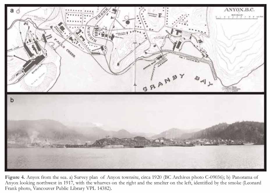
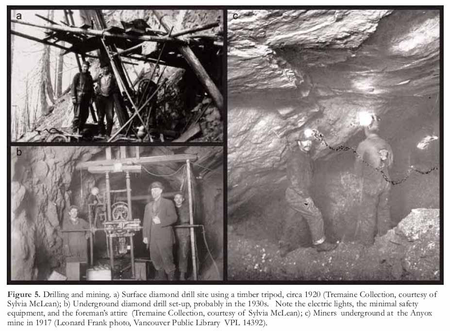
Location and Access
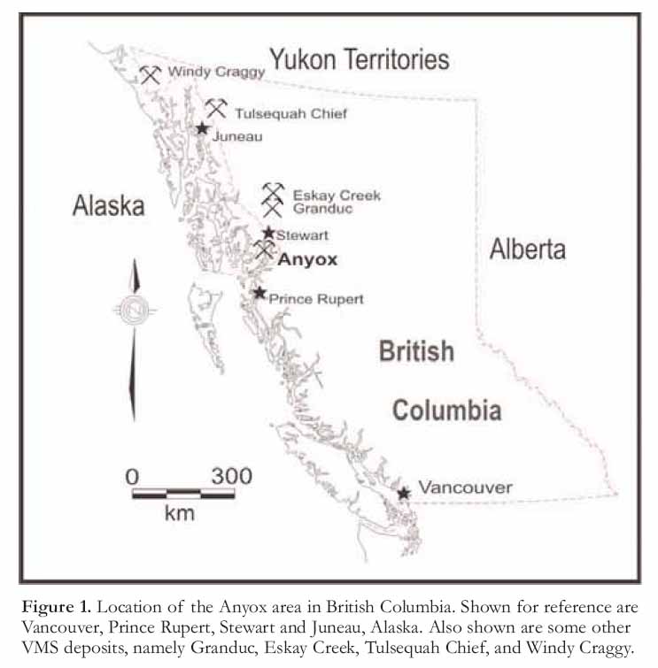
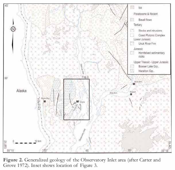
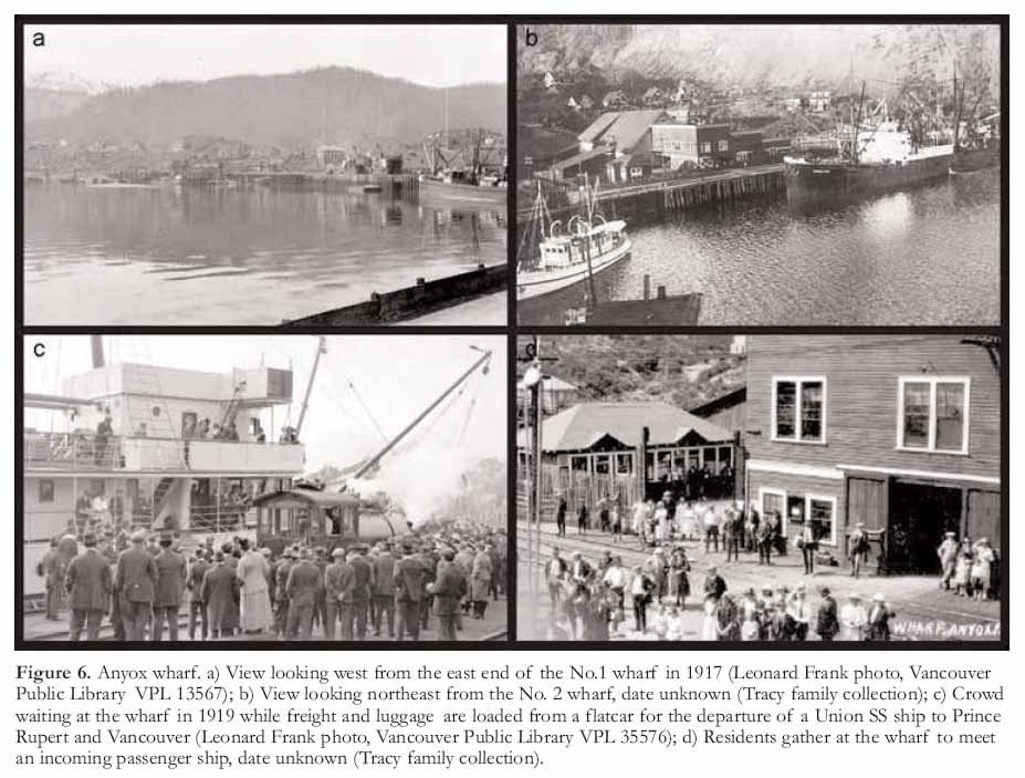
2 Anyox is situated at sea level, 145 km north of Prince Rupert near the head of Observatory Inlet, an arm of Portland Canal, which is the most northerly fiord on the British Columbia coast (Figs. 1, 2). The Portland Canal, which is located 17 km west of the mine, forms the International Boundary between BC and the Alaska Panhandle (Fig. 2). The mine site is situated at 55° 26’ N and 129° 49’ W, within NTS map-sheet 103P/05W. Prior to the introduction of float-equipped aircraft on the northern coast, it was accessible only by boat.
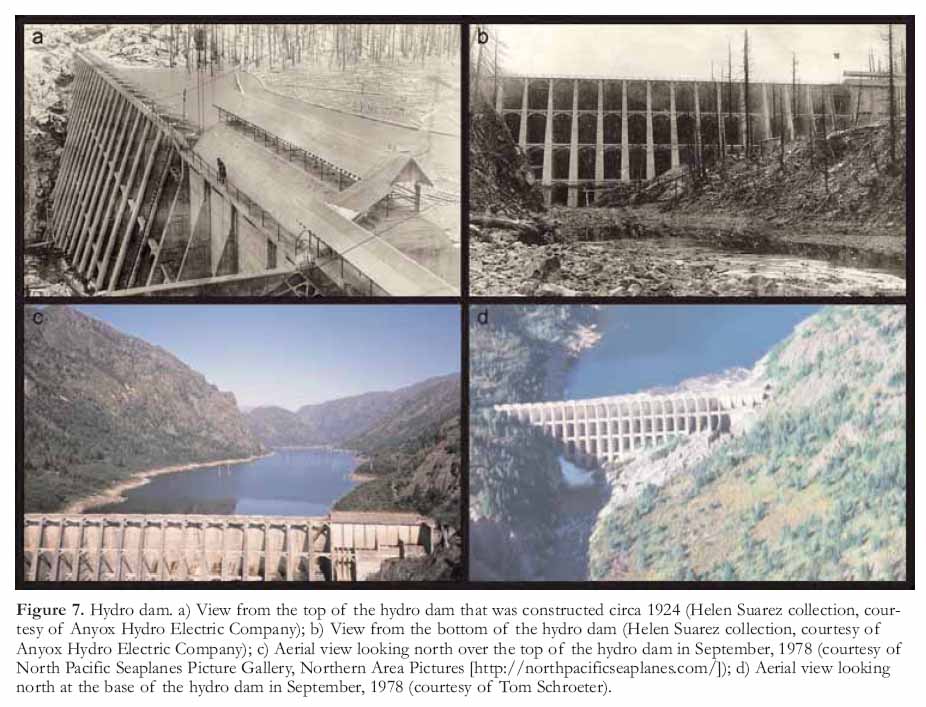
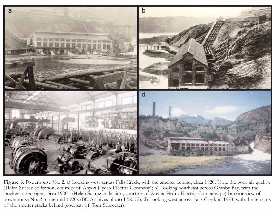
3 The district lies within a temperate rainforest and snow is rare at sea level, but accumulates at higher elevations where the mine is located. The area is within the Boundary Range of the Coast mountains that are characterized by craggy ridges and broad U-shaped glaciated valleys. The highest point in the area is Mount Clashmore at 5509 ft (1675 m) which is approximately 10 km northwest of Anyox. The tree line is at ~3000 ft (~900 m) having mainly pine and alder growth following a devastating fire in 1942.
Sources of Information
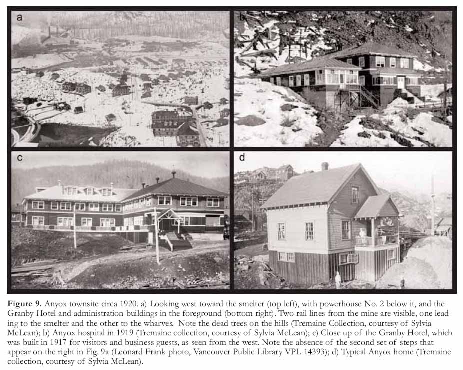
4 Much of the geological information has been taken from government-funded geoscience publications, both provincial (Carter and Grove 1972; Grove 1986; Alldrick 1986, 2000) and federal (Evenchick and Holm 1997; Evenchick et al. 1997; Evenchick and McNicoll 2001). Three graduate theses have been completed on the deposit and surrounding area by Macdonald (1999), Smith (1986) and Sharp (1980). Most recently, between 1993 and 1995, the area was the subject of a research program by the Mineral Deposit Research Unit of the University of British Columbia, which supported the research of Rob Macdonald (Macdonald et al. 1996). The area has undergone episodic phases of exploration and development since 1900 with numerous prospectors, geologists and miners contributing observations to the geology and mineral deposits.
HISTORY OF EXPLORATION AND DEVELOPMENT
5 Anyox is now a ghost town, one of many that reflect the boom-and-bust scenario of British Columbia’s early mining history. These were remote, single economy company towns or public boom-towns that sprang up with the development of a mine and faded into obscurity when the ore was gone. In the case of remote mines, the mine owner was generally forced to provide most of the services to the community. Anyox is a classic example of a company town. For a quarter of a century (1911-1936), it existed as a world unto itself. It grew, it thrived and it died in relative obscurity despite the fact, that at its heyday, it had a population of approximately 2500 people.
6 Observatory Inlet (Fig. 2) was the traditional hunting and trapping grounds of the Nisga’a Indians of the Nass Valley. Their lore included reference to a golden mountain adjacent to the inlet, just the sort of lure to draw gold-hungry prospectors. In late May, 1889, John Flewin, Resident Mining Recorder for BC’s north coast, and Charles Todd, an Indian Agent for Northern BC, ventured into Goose Bay (now known as Granby Bay). Flewin discovered a piece of promising looking chalcopyrite float, a possible indicator that a copper deposit was not far away. In his words, "Subsequently I grub-staked two or three prospectors to prospect the Observatory Inlet country, not only Goose Bay but also Hastings Arm, and Maple Bay on Portland Canal (Fig. 2). Mr. Todd declined to go into the venture with me as he said, "even if we discovered a large body of ore it would be impossible to do anything with it for years to come, unless it was a gold proposition" (Flewin 1924). Flewin and Todd did not find the source of the float on that trip but Flewin was sufficiently intrigued to plan a return trip.
7 "In May 1900, in company with my eldest son, H.C. Flewin, and E. Donohue and an Indian named Albert Allen, I ascended Bonanza Creek, Goose Bay, where I had found the piece of float in 1889, and on the 19th of the month discovered and located the large body of ore on the "Bonanza" mineral claim at the junction of Bonanza and Mineral Creeks" (Flewin 1924). The news of a possible copper discovery caught the attention of copper baron Marcus Daly, from Butte, Montana, one of the founders of the giant Anaconda Copper Mining Company. Daly died in 1900 but his scout, M.K. Rodgers visited the property with Flewin in 1901 and negotiated an 18-month option with Flewin on behalf of Daly Estates for $45 000. Rodgers was later the guiding force behind the early development of the Nickel Plate Mine in the Hedley, B.C. mining camp.
Figure 1. Location of the Anyox area in British Columbia. Shown for reference are Vancouver, Prince Rupert, Stewart and Juneau, Alaska. Also shown are some other VMS deposits, namely Granduc, Eskay Creek, Tulsequah Chief, and Windy Craggy.
Display large image of Figure 1
8 Flewin returned to the area in 1901 with some experienced prospectors and discovered the Hidden Creek group of ore bodies (Fig. 3, # 8), which were also bonded to Daly Estates. Development work ensued that summer but the options were dropped after a visit by the Daly Estate geologist. Flewin had trouble raising more capital, but he was able to form a company, Hidden Creek Copper Co., in June 1905, which raised $50 000. Unfortunately, the company was forced to put the property up for sale by 1908. Rodgers, who had remained steadfast in his belief in the merits of Hidden Creek, and T. Hodgins, a mining financier who was also from Butte, purchased the property for $135 000. Rodgers and Hodgins "continued development work on a large scale until 1910" (Flewin 1924). Initial development work generated enough excitement to interest the Granby Consolidated Mining, Smelting and Power Co., which purchased Hodgins’ 80% interest in the property for $600 000, in spite its remoteness; Rodgers retained his 20%.
9 Granby was the largest producer of copper in the province. Its smelter at Grand Forks, fed by the Phoenix Mine, was one of the most efficient processors of low-grade copper ore in the world. With that mine nearing the end of its life, Granby needed to find a replacement. After searching throughout BC, Washington State and Western Canada, the company concluded that the Hidden Creek deposit was its best bet. In 1911, Granby christened the new community Anyox, an anglicized version of the Nisga’a word Anyoose, meaning "hidden water".
Figure 2. Generalized geology of the Observatory Inlet area (after Carter and Grove 1972). Inset shows location of Figure 3.
Display large image of Figure 2
10 If a mining company had to face the challenge of building an entirely self-sufficient mine, concentrator, smelter and town in a remote site on the northern coast of British Columbia, the physical setting of Observatory Inlet was close to perfection. Beyond the quiet waters of the inlet was a wide square valley ringed by thickly forested hills, which in turn were surrounded by mountains. The combination of the rugged mountains and the region’s robust rainfall provided excellent potential for hydroelectric power generation and the harbour, which had exceptionally high tides, was ideal for accommodating deep-sea freighters.
11 During the development of Anyox, Lady Luck did not just smile on the company, she beamed. Everything the company touched seemed to have a hidden bonus and in one case, literally turned into a pot of gold. During the removal of a small island to widen and deepen the harbour, blasting exposed a quartz vein that contained enough gold to yield a profit of $3 million, enough to pay for the entire cost of building the town and processing facilities. This vein and several similar quartz veins nearby proved to be perfect flux, an essential ingredient in the smelting process. Later, a layer of bluish clay, encountered while digging sewers for the town, was recognized as the rare type suitable for lining retorts and furnaces in the smelter. Until that moment, Granby had been forced to import this clay from the eastern United States at great expense.
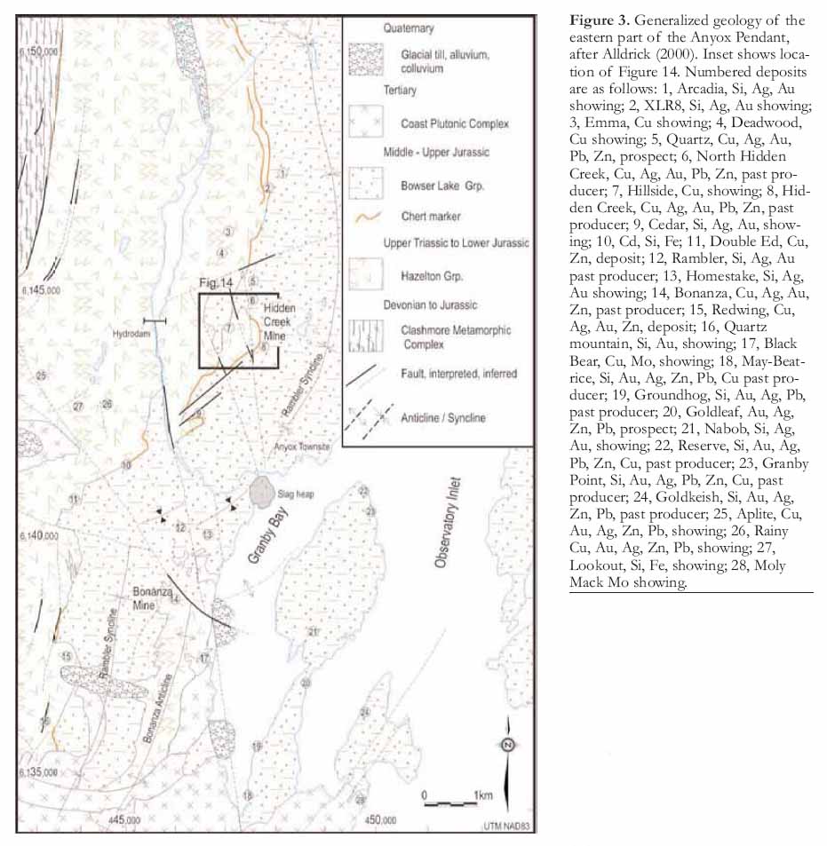
12 Development work began in 1911 on the orebodies, which cropped out about 2.5 km north of the wharf on Granby Bay (Figs. 3, 4), and between 190 and 275 m above sea level. "The mine was opened by six tunnels and fifty thousand feet of diamond drilling was done prior to and contemporaneously with the first tunnel work" (Dunn 1924). It was heavy, dark and dangerous work. "Initially, the miners used candles for light as they manoeuvred their heavy drills to tunnel into the ore bodies. In 1914, the miners switched to carbide lamps that they purchased themselves, while the company supplied the fuel. In 1916, lighter and more versatile drills were put into operation" (Griffin 2002). By 1918, 11 300 m of drifting and raising, and over 29 200 m of diamond drilling (surface and underground) had been completed (Bancroft 1918; Fig. 5).
13 The hub of the town was a broad wooden dock about 15-m wide and 400-m long that stretched around the waterfront like a giant veranda (Fig. 4). A 1923 newspaper clipping indicated that the Union Steamship Co. of B.C. Ltd. had a weekly sailing from Vancouver to Ocean Falls, Swanson Bay, Prince Rupert, Anyox, and Alice Arm, departing from the Union Dock at the foot of Carrall Street, Vancouver, every Friday at 9 pm. These ships, carrying passengers and freight, brought the outside world to the isolated souls of Anyox. The mine and docks were linked by 32 tonne steam and electric locomotives operating on three kilometres of railway. Up to 5400 tonnes of ore were hauled from the mine to the concentrator near the waterfront each day, in 75 ore cars, powered by the energy provided from the hydro dam and coal fired generators. "The docks were fitted with overhead travelling cranes and huge derricks as well as three travelling ore bunkers. They ran around the harbour wall to the coke plant where coal was turned into hot fuel for the smelter and the production lit the skies red each night as the coke came out of the furnaces" (Loudon 1973). The docks were large enough to berth three or four deep-sea freighters and coastal passenger vessels simultaneously (Fig. 6).
14 The need for power at any mine is great and a lack of affordable power has high-centred more than one mighty deposit in this vast country. Anyox was blessed with the natural attributes that made power generation relatively easy. Anyox Creek drains a catchment area of approximately 125 square kilometres and is fed by a combination of glacial meltwater and runoff from the mountains that rim the catchment basin. For its final few kilometres, the creek flows through a winding canyon that contains several rapids and waterfalls. To provide power initially, Granby engineers built a rock-filled wooden structure 52-m long and 40-m wide about 4.5 km upstream from the mouth of Anyox Creek (Fig. 3). The reservoir was capable of storing sufficient water to operate about 10 000 HP of water wheels, which drove various air compressors, blowers, electrical generators and sundry pumps. Granby later constructed a second larger dam of reinforced concrete to increase the capacity of the reservoir by about 28 100 acre-feet. This enabled the installation of an extra power unit consisting of a 5000 HP Pelton water wheel that was directly coupled to a 4300 KW generator. The dam was an Eastwood multiple-arched type (27 arches) with a length of 208 m and a maximum height of 42 m, which was built upon rock foundations (Fig. 7). The installation of four siphonic spillways to ensure rapid discharge of water during a flood was a notable feature. The powerhouse was built at the mouth of Anyox Creek on Granby Bay (Fig. 8). A steam plant, with a capacity of about 6000 HP, was also installed to supplement hydropower shortages due to low-water conditions during winter months. It was fired by coal gas generated at the coking plant, together with tar from the same source (Dunn 1924). After the mine was closed in 1935, the concrete arch storage dam was breached in several places to allow water to flow through and prevent the dam being overtopped.
Figure 3. Generalized geology of the eastern part of the Anyox Pendant, after Alldrick (2000). Inset shows location of Figure 14. Numbered deposits are as follows: 1, Arcadia, Si, Ag, Au showing; 2, XLR8, Si, Ag, Au showing; 3, Emma, Cu showing; 4, Deadwood, Cu showing; 5, Quartz, Cu, Ag, Au, Pb, Zn, prospect; 6, North Hidden Creek, Cu, Ag, Au, Pb, Zn, past producer; 7, Hillside, Cu, showing; 8, Hidden Creek, Cu, Ag, Au, Pb, Zn, past producer; 9, Cedar, Si, Ag, Au, showing; 10, Cd, Si, Fe; 11, Double Ed, Cu, Zn, deposit; 12, Rambler, Si, Ag, Au past producer; 13, Homestake, Si, Ag, Au showing; 14, Bonanza, Cu, Ag, Au, Zn, past producer; 15, Redwing, Cu, Ag, Au, Zn, deposit; 16, Quartz mountain, Si, Au, showing; 17, Black Bear, Cu, Mo, showing; 18, May-Beatrice, Si, Au, Ag, Zn, Pb, Cu past producer; 19, Groundhog, Si, Au, Ag, Pb, past producer; 20, Goldleaf, Au, Ag, Zn, Pb, prospect; 21, Nabob, Si, Ag, Au, showing; 22, Reserve, Si, Au, Ag, Pb, Zn, Cu, past producer; 23, Granby Point, Si, Au, Ag, Pb, Zn, Cu, past producer; 24, Goldkeish, Si, Au, Ag, Zn, Pb, past producer; 25, Aplite, Cu, Au, Ag, Zn, Pb, showing; 26, Rainy Cu, Au, Ag, Zn, Pb, showing; 27, Lookout, Si, Fe, showing; 28, Moly Mack Mo showing.
Display large image of Figure 3
Display large image of Figure 4
15 There were two distinct parts to the town: the flats adjacent to Hidden Creek and the slope to the west (Fig. 4a). Most of the mine workers, primarily single men, lived in two very large bunkhouses, located on the flats between the smelter, machine shop complex and the mine. These bunkhouses were "home" to 300 men. There was a separate bunkhouse for the Chinese workers who cleaned the bunkhouses, ran the laundry and worked in the mess hall. There were also three, five-family apartments, twenty small one-story houses and 12 two-story, five-room houses. According to Dolmage (1922), the payroll included 284 labourers from over 15 nationalities in 1922, before the concentrator was built. They earned between $3.25 and $6.40 per day.
16 The high side of town (Figs. 4a, 9a) was where the white-collar workers lived. The top brass had the largest homes, while those involved in running the business aspect of the mine, the shop keepers, and plant workers, lived with their families in row upon row of two-story houses, all virtually identical (Fig. 9d). The lack of individuality was made up for by the fact that the level of accommodation provided by Granby was far superior to anything that the workers could have afforded to buy in a major centre such as Vancouver.
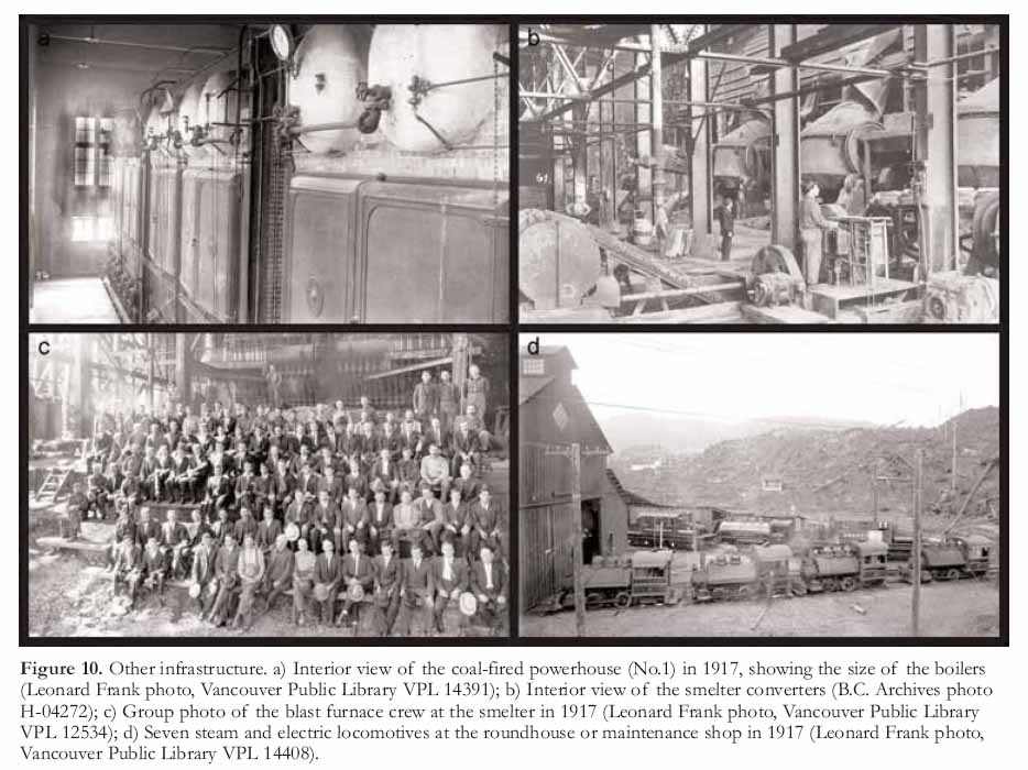
17 The crusher, concentrator, smelter and their auxiliary repair shops occupied the south side of the valley, along with the hydro and steam power plants (Figs. 4a, 10a). "The blacksmith shop had a crew of 10 while the machine shop, reputed to be the most up-to-date on the BC coast, had a crew of 35 machinists and helpers" (Loudon 1973). The calibre of the craftsmen employed at Anyox was extremely high and, in terms of apprentice training, the machine shop was considered one of the finest industrial schools on the west coast. "Certainly the machine shop was huge even by today’s standards. It had 13 lathes and two planers, an 18 tonne overhead crane, a shaper and a milling machine. The shop manufactured 90 % of the parts required by the whole Anyox operation. The tradesmen who ran it were drawn from the industrial complexes of England, Scotland and continental Europe mainly and they knew themselves to be masters of their craft" (Loudon 1973).
18 In 1914, the blast furnace of the 2000 tonne per day smelter was ‘blown-in’, signalling the start of production. The smelter, with its 50 m tall stack, dominated the landscape (Fig. 9a, top left). Because of the rich grade of the ore, the metallurgical process consisted of partial pyritic smelting without previous roasting or concentrating (Dolmage 1922). Blister copper (copper in the range of 99% purity) was produced by blasting air through the molten copper to remove impurities and drive off most of the sulfur as sulfur dioxide. The richest ore near the surface was mined first and as the average grade gradually dropped, Granby built a concentrator (mill) in 1924 to remove some of the gangue minerals prior to sending the remainder to the smelter. In the early years, another product called ‘pyrite ore’ was also shipped to market.
Figure 5. Drilling and mining. a) Surface diamond drill site using a timber tripod, circa 1920 (Tremaine Collection, courtesy of Sylvia McLean); b) Underground diamond drill set-up, probably in the 1930s. Note the electric lights, the minimal safety equipment, and the foreman’s attire (Tremaine Collection, courtesy of Sylvia McLean); c) Miners underground at the Anyox mine in 1917 (Leonard Frank photo, Vancouver Public Library VPL 14392).
Display large image of Figure 5
19 The blister copper was initially barged to Seattle and then transported by rail to the Nichols Chemical Company in New York for refining (Dolmage 1922). Later, Granby production was shipped to a new smelter/refinery complex built at Tacoma, Washington. The Anyox smelter also processed custom ore from other deposits on the coast of British Columbia and southeastern Alaska.
20 The coking coal required for Granby’s smelters at Grand Forks and Anyox was shipped in from Fernie, in the southeast corner of BC, and from Union Bay on Vancouver Island. In 1919, an extended strike by union workers at the Fernie coal mines halted coking coal shipments to the Phoenix smelters. This interruption to production at the Anyox smelter was the impetus behind Granby’s decision to expand into coal mining. In 1917, Granby acquired the Cassidy Coal Company, south of Nanaimo on Vancouver Island, and operated the Granby No.1 Colliery until 1932. Peak production was in the early 1920s.
21 The smelter produced sulfurous fumes that literally killed all vegetation in the inlet as far away as Alice Arm (Fig. 2). The tips of the silver grey skeletons of the trees are still visible today above the verdant green of the returning forest. Seeing the effect the fumes had on the vegetation, just imagine what they did to the lungs and cardiovascular systems of the workers in, and the residents around, the smelter. The men who worked in the smelter were dubbed "gas-eaters", a term heavy with implication as to the severity of their working conditions. At times, the gas was so intense, that the men who operated the loading cranes were unable to work more than two hours at a stretch. At the end of their shifts, they emerged covered in dust, spitting and coughing up yellow sulfur.
22 A temperature inversion in 1926 created a fortnight-long fog that trapped the gas at ground level. An epidemic of nosebleeds was attributed to the trapped gas. Many residents stuffed newspaper around the doors and windows in an attempt to keep the toxic fog from filtering into their homes. The furnace discharge was very visible in the winter after a fresh snowfall. A favourite winter thrill for the town’s youngsters was to light the snow on fire. The housewives planned their washdays based on the direction of the wind and remained vigilant in monitoring it, in case it shifted and drenched the clean clothes with black soot. There was no such thing as a garden, nor was there any wildlife in the vicinity as there was neither sustenance nor cover.
Figure 6. Anyox wharf. a) View looking west from the east end of the No.1 wharf in 1917 (Leonard Frank photo, Vancouver Public Library VPL 13567); b) View looking northeast from the No. 2 wharf, date unknown (Tracy family collection); c) Crowd waiting at the wharf in 1919 while freight and luggage are loaded from a flatcar for the departure of a Union SS ship to Prince Rupert and Vancouver (Leonard Frank photo, Vancouver Public Library VPL 35576); d) Residents gather at the wharf to meet an incoming passenger ship, date unknown (Tracy family collection).
Display large image of Figure 6
23 As shocking as it is today to conceive that such environmental destruction took place unchecked, it must be remembered that environmental regulation was not a consideration in those days. If one good positive comment can be made regarding the environmental legacy of mines such as Anyox, it is that it provides a good measuring stick by which to judge how far the industry has come in terms of minimizing its impact on the environment. Mining operations today should not be judged on the practices of a previous era.
24 Everyone in Anyox lived with a constant dread of fire. The combination of the dead forest that embraced the inlet, the wooden plank road system that was necessary to traverse the spongy muskeg, and the muskeg itself, which was prone to spontaneous combustion in the summer, created a real, and twice-realized, fire hazard. Fire buckets, which had round bottoms to prevent them from being stolen for home use, were hung beside 200 litre water drums along all roads and paths. The first fire, in 1923, caused heavy damage, including the loss of the powder magazine, which blew up in a spectacular explosion that had the townspeople fleeing to the harbour. The town was rebuilt quickly with little interruption to production. However, the next big fire drew the curtain on Anyox in 1942 - but more on that later.
25 Despite its remoteness, Anyox was a fully equipped town with all the modern amenities available at that time. It had two hospitals – a small emergency hospital near the mine and a much larger one in town that was the best equipped and most modern on the coast north of Vancouver, including three doctors, eighteen beds and modern x-ray equipment (Fig. 9b). Medicare was provided through Granby. Medical and surgical care cost $1/month for single men and $2/month for a family.
26 The spiritual needs of the community were also met. There were Anglican and Catholic churches (Fig. 4a) as well as another that served both the Methodist and Presbyterian congregations. The community also had a rather large cemetery, its white crosses brightening one section of the otherwise bleak hillside. When there was a funeral, the coffin was carried through the town by pallbearers or on the town’s one flatbed truck. The mourners walked behind the coffin to the cemetery - a reflection of the European heritage of much of the population.
Figure 7. Hydro dam. a) View from the top of the hydro dam that was constructed circa 1924 (Helen Suarez collection, courtesy of Anyox Hydro Electric Company); b) View from the bottom of the hydro dam (Helen Suarez collection, courtesy of Anyox Hydro Electric Company); c) Aerial view looking north over the top of the hydro dam in September, 1978 (courtesy of North Pacific Seaplanes Picture Gallery, Northern Area Pictures [http://northpacificseaplanes.com/]); d) Aerial view looking north at the base of the hydro dam in September, 1978 (courtesy of Tom Schroeter).
Display large image of Figure 7
27 Graves of veterans were distinguished by cement helmets, which were commissioned by the company. When the call came for men to fight in WWI, Granby sent 400 workers. Many of those who survived returned to Anyox and their former jobs; those who had lost limbs were given light duty jobs.
28 All the homes, shops, bunkhouses and administration buildings had electricity and the streets of Anyox were brightly lit on dark winter nights. The residents of Anyox used a unique style of light bulbs in their homes. In an effort to prevent pilfering of light bulbs by workers, Granby had the word "Stolen" stencilled on the glass bottoms of all the light bulbs purchased for company use. Some households blatantly displayed the bulbs with the incriminating word while others went to some effort to sand the evidence from the glass.
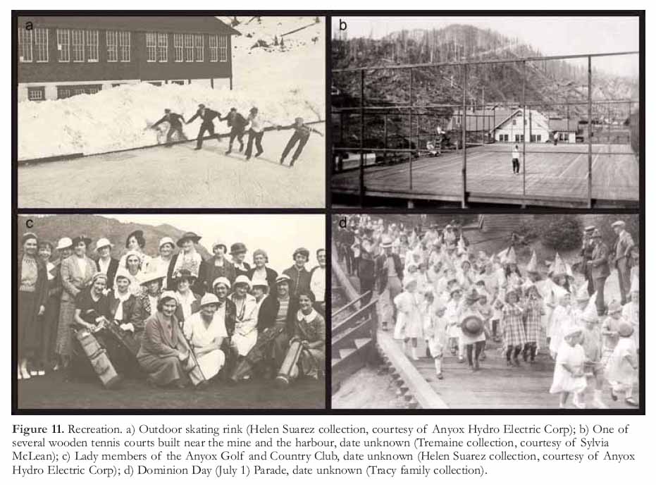
29 The quality of life, apart from the fumes from the smelter, was quite high in comparison to the outside world. Granby paid the taxes for its employees so residents enjoyed a tax-free life, something most of us just dream about. The houses all had bathrooms and indoor running water, luxuries at the time. The town boasted its own movie theatre, newspaper, telegraph office, post office, a three-story general store, butcher shop, liquor store, and 45-room hotel (Fig. 9c) with a three-room library annexed to it. The schools attracted good teachers and offered classes from Grades 1 to 11, which was the matriculation year in those days. The residents enjoyed a wide choice of sports (Fig. 11) including ice hockey, tennis and a nine-hole golf course that was laid out on the smelter slag (which had not a single blade of grass). In 1934, there was also a taxi service, a government agent who served as a mining recorder, a branch of the Bank of Commerce, a Customs office, a drug store, a cafe, a pool hall, two insurance agents, a dentist and an optometrist, a barber shop, two Masonic Lodges, two Oddfellows Lodges, and an Elks Hall (Sun Directories 1935).
30 Yes, Anyox had it all, including labour disputes. The first, in 1916 was relatively minor but the second, in the winter of 1933, marked the beginning of the end for Anyox. When the price of copper plummeted, along with everything else, during the Great Depression, the company insisted on a wage reduction. The miners responded with a strike. This shook the town to its roots. As told by Peter Loudon (1973), a student in Anyox at the time, "We were all milling about in the schoolyard waiting the bell which would line us up to march into classes. Suddenly all the fooling around stopped and there was a strange silence. All the kids were looking up the plank road to the mine. All our lives previously that road had been barren of anything or anyone because only the jitneys appeared to use it and that was later in the day. But the road was filled with men, hundreds of men. They were wearing their hard hats and walking purposefully in a tight body. They weren’t talking but you could hear their feet pounding the boards. You could smell their determination as they headed past us toward the beach. None of us had seen anything like it. It was so ominous that some of the kids verged on tears, scared without knowing why. At that very moment everything changed for us in Anyox."
Figure 8. Powerhouse No. 2. a) LLooking west across Falls Creek, with the smelter behind, circa 1920. Note the poor air quality. (Helen Suarez collection, courtesy of Anyox Hydro Electric Company); b) Looking southeast across Granby Bay, with the smelter to the right, circa 1920s. (Helen Suarez collection, courtesy of Anyox Hydro Electric Company); c) Interior view of powerhouse No. 2 in the mid-1920s (BC Archives photo I-52572); d) Looking west across Falls Creek in 1978, with the remains of the smelter stacks behind (courtesy of Tom Schroeter).
Display large image of Figure 8
31 The town had two policemen, a BC provincial police constable and a company security officer. These two likely felt quite vulnerable so, after that first peaceful yet ominous march of men, they requested assistance from Prince Rupert. A police launch with a staff sergeant and seven constables arrived, followed by an additional ten officers and an inspector. Again the miners, unarmed, marched down the plank road to the docks but this time they were confronted by the armed police. After some pushing and shoving the police gave way and the march proceeded. The police arrested those men thought to be involved in the fight as well as an additional group of men suspected of being troublemakers. These men, upward of 300, were ordered to leave town but others also left in a show of support.
32 Shortly after the dispute, Granby posted notices that headquarters had ordered the mine closed but made it known that should a sufficient number of men return to work, the mine would continue production. Most of the remaining workers chose to return to work. Hungry men, idled by the Depression, began arriving in the town, having heard that jobs were available. It came as a complete shock to the townspeople, who had been relatively insulated from the harsh economic reality, to see men, hardened by life on the road, arriving to take the place of the deported miners.
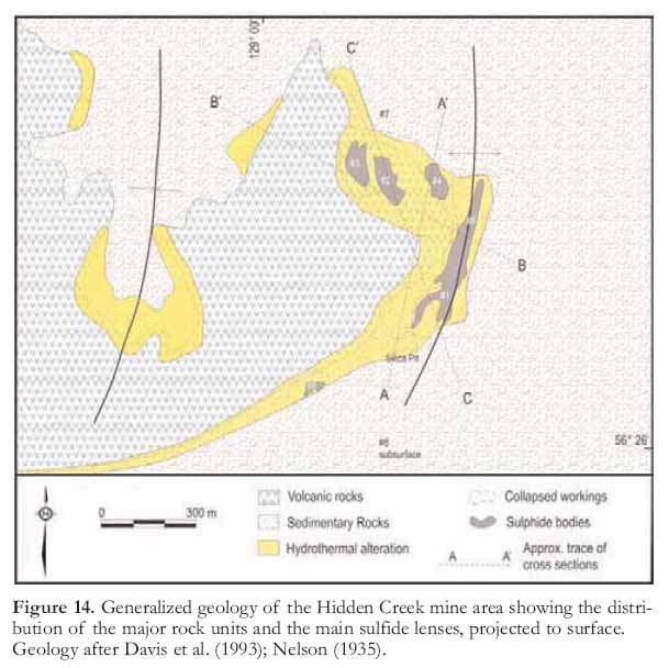
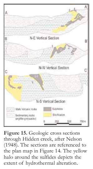
Figure 9. Anyox townsite circa 1920. a) Looking west toward the smelter (top left), with powerhouse No. 2 below it, and the Granby Hotel and administration buildings in the foreground (bottom right). Two rail lines from the mine are visible, one leading to the smelter and the other to the wharves. Note the dead trees on the hills (Tremaine Collection, courtesy of Sylvia McLean); b) Anyox hospital in 1919 (Tremaine collection, courtesy of Sylvia McLean); c) Close up of the Granby Hotel, which was built in 1917 for visitors and business guests, as seen from the west. Note the absence of the second set of steps that appear on the right in Fig. 9a (Leonard Frank photo, Vancouver Public Library VPL 14393); d) Typical Anyox home (Tremaine collection, courtesy of Sylvia McLean).
Display large image of Figure 9
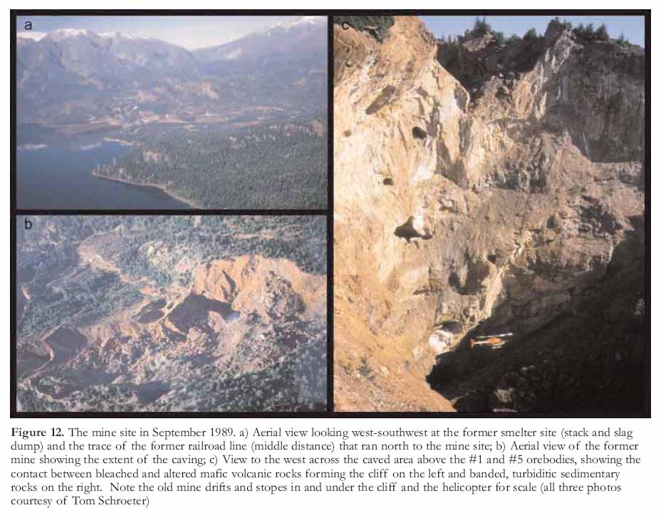
33 The curtain call for the mine came in the form of a massive explosion, reputed to be the largest man-made mining explosion in history at the time. Faced with shrinking reserves, Granby conceived a plan whereby several separate, large masses of low-grade ore would be blasted into the existing stopes beneath what was known locally as the ‘glory hole’ (Fig. 12). This was a large opening at surface that was created as early as 1918 after the original outcrop of the No. 2 orebody was mined (Bancroft 1918). The blasted ore would be hauled to surface through a series of new drifts driven at the deepest level of the mine. While this is common practice today, it was novel in 1934.
34 Preparations for this explosion began several months in advance. Those who lived near the mine were instructed to prepare their homes for the impending shake, rattle and roll. Homes within a 2.5 km radius were evacuated, the classes at the school were cancelled for the morning, the hospital was evacuated and the patients moved to nearby homes. The hospital was not within the danger zone but it was situated beneath a steep rocky hillside and there were concerns that it would be swept away if a landslide was triggered.
35 At 10 am on November 27, 1934, the whistles blew and the citizens of Anyox collectively held their breath. "… A cloud of black smoke shot into the air above the mountain and we heard the boom roll down the valley, a disappointing boom really. There was no apparent surface damage" (Loudon 1973). The much anticipated explosion was considered anticlimactic in light of the build-up to the event. Classes resumed and the people went back to their houses, but, "At about 3 o’clock that afternoon, those of us who were day-dreaming in class while gazing out the window, saw a terrible thing. To our eyes it appeared as if the whole side of the mountain suddenly fell in on itself. Actually, as we learned later, one intention of the blast was to join two open-pit mines or glory holes, as we called them. The overhang around the top edge of the glory hole closest to the school caved into the hole. The air filled with dust and small debris where the cave-in took place and it was a far more satisfactory sight than the explosion had been. It looked finally as if a giant had carved a huge wedge out of the mountainside" (Loudon 1973, p. 98-99).
Figure 10. Other infrastructure. a) Interior view of the coal-fired powerhouse (No.1) in 1917, showing the size of the boilers (Leonard Frank photo, Vancouver Public Library VPL 14391); b) Interior view of the smelter converters (B.C. Archives photo H-04272); c) Group photo of the blast furnace crew at the smelter in 1917 (Leonard Frank photo, Vancouver Public Library VPL 12534); d) Seven steam and electric locomotives at the roundhouse or maintenance shop in 1917 (Leonard Frank photo, Vancouver Public Library VPL 14408).
Display large image of Figure 10
36 The quantity of explosives needed for the blast had been estimated but this was a new experimental technique. As it turned out, the miners had seriously overestimated the amount of powder that was required. The resulting blast not only shattered the intended mineralization, but also the newly constructed tunnels and crackled the surrounding rock to the point that it would never again support new tunnels. The resulting huge pit, which is commonly referred to as the ‘glory hole’, is actually the surface expression of the caved underground mine (Fig. 12). The blast, which was intended to prolong the life of the mine and community, ironically, was the death knell for both.
37 Outside Observatory Inlet, the world was being strangled by the Great Depression. The bottom fell out of the copper price and Anyox, being a single economy town, was bereft of a buffer. Forces beyond Granby governed the future of the town. The company kept the operation going but finally succumbed to the influences of the depressed global economy. By early 1935, close to 50 million kilograms of unsold copper, the equivalent of three year’s worth of production, sat in a huge, coffin shaped stack near the harbour. Mining operations ceased on July 31, 1935. One thousand people were laid off and 2500 people became virtually homeless overnight in one of the most desperate periods of modern history.
38 Granby dismantled and shipped out most of the machinery from the mine, mill, machine shop, powerhouses, and town, including kilometres of rails and the steam and electric locomotives that for years had trundled back and forth to feed the mines. A skeleton crew of about 15 men and a few family members stayed behind, while everyone else departed with what furniture and keepsakes they could carry. For the children who knew only the security and safety of Anyox, it must have been terrifying – even more so for their parents as they set forth into a future that would remain bleak, harsh and desperate until the economy began to recover with the onset of World War II.
39 The town of Anyox went out in a blaze – perhaps not a blaze of glory, but it was definitely an impressive, all consuming blaze. In early July 1942, after a particularly heavy thunderstorm, a lightning strike about six miles west of town ignited the tinder dry forest of dead trees. Another lightening strike hit three miles northwest of the town and the two fires raced down the valley. The forest burned, the muskeg burned, the wooden plank roads burned, the houses burned – the inferno devoured the town. The skeleton crew of men was simply not up to the task of fighting a fire of this magnitude and they and their families were forced to flee to a waiting barge and watch helplessly from the sanctuary of the inlet waters. When it was all over, the town of Anyox had been wiped from the face of the earth.
Figure 11. Recreation. a) Outdoor skating rink (Helen Suarez collection, courtesy of Anyox Hydro Electric Corp); b) One of several wooden tennis courts built near the mine and the harbour, date unknown (Tremaine collection, courtesy of Sylvia McLean); c) Lady members of the Anyox Golf and Country Club, date unknown (Helen Suarez collection, courtesy of Anyox Hydro Electric Corp); d) Dominion Day (July 1) Parade, date unknown (Tracy family collection).
Display large image of Figure 11
40 Today, the inlet has healed from its former stature as an environmental wasteland. The hills are once again clad in thick forest, the waters abound with seals and salmon and wildlife has returned and is thriving in the undergrowth. There is little evidence of the town, the mine and the lives lived there, although every year, spring bulbs burst forth, their vibrant colours, a tribute to the tenacity of nature.
Post-Granby History
41 The Anyox property was purchased by Consolidated Mining and Smelting Company of Canada (now Teck Cominco Ltd.) soon after Granby closed the mine in 1936. Granby had directed almost its entire effort towards development of the sulfide lenses exposed at surface and had conducted only limited exploration in the surrounding area. In hopes of discovering a new deposit, Cominco carried out a series of exploration programs in 1937 and 1938, including surface diamond drilling and underground exploration. Cominco resumed its exploration in 1950 and conducted detailed programs annually for the next decade. The highlights included the discovery of the Double Ed and Eden prospects in 1952, with much of the follow up conducted around the Double Ed (Fig. 3, #11).
42 In 1973, Cominco began to examine the potential for large, low-grade bulk mining of the copper mineralization near Hidden Creek using geophysical surveys. That was followed by drilling in 1981 to 1983, which outlined a "potential mineralized ore reserve" of 50.8 million tonnes grading 0.6% copper equivalent, of which about one third was accessible by open pit. Several additional phases of geophysics and drilling were conducted, until 1990, by Cominco and a partner, Prospector Airways. In a 1990 economic assessment of the property, Cominco calculated a resource of 10.8 to 13.6 million tonnes grading 0.7 to 0.75% Cu (Davis et al. 1993). Cominco then sold the project to Moss Management and Boston Financial Corp. (Davis and Aussant 1994).
Figure 12. The mine site in September 1989. a) Aerial view looking west-southwest at the former smelter site (stack and slag dump) and the trace of the former railroad line (middle distance) that ran north to the mine site; b) Aerial view of the former mine showing the extent of the caving; c) View to the west across the caved area above the #1 and #5 orebodies, showing the contact between bleached and altered mafic volcanic rocks forming the cliff on the left and banded, turbiditic sedimentary rocks on the right. Note the old mine drifts and stopes in and under the cliff and the helicopter for scale (all three photos courtesy of Tom Schroeter)
Display large image of Figure 12
43 In 1992, Beacon Hill Consultants conducted an evaluation of the Hidden Creek deposit, calculated that an indicated mineable "reserve" of 26.7 million tonnes grading 1.08% copper, 0.005 oz/ton gold and 0.3 oz/ ton silver was present, and concluded that it could be mined with an open pit and conventional mill. Following this report, in 1992, TVI Copper Inc. carried out an exploration program around the Hidden Creek deposit with inconclusive results (Davis and Aussant 1994).
44 In 2006, Kenrich-Eskay Mining Corp., conducted an airborne geophysical survey followed by geo-chemical surveys, geologic mapping and over 14 000 m of diamond drilling, mainly at the Double Ed prospect. As a result of this work, an indicated resource of 1 850 000 tonnes grading 1.6% Cu, 1.0% Zn and 15.1g/t Ag was defined (Harrison and McKinley 2007).
45 There are currently two projects underway at Anyox, neither of which involves mineral exploration. One of these consists of studies of the feasibility of installing a new hydroelectric generating facility. The concrete dam that provided electricity to the smelter and community is being restored by Anyox Hydro Electric Corp. (AHEC). The Anyox townsite and dam were purchased from Cominco in 1984 by Moss Management with the idea of reviving the mine. However, increasing power demands from the US and progressive deregulation in BC shifted their focus to rehabilitation and revitalization of both the Anyox dam and the Kitsault dams. The two dams could produce between 30 and 40 megawatts of power, which would be transmitted to BC Hydro’s Kitsault Sub-station via an underwater cable. AHEC has an economic agreement with the Gincolx Village Government. The company is working through the various levels of the permitting process and has autumn 2010 as the target for commercial operation.
46 The old slag pile that sits on the beach at Anyox is also the scene of a modern recycling program by True-Grit Abrasives, which has operated a quarry there since 1990. The slag, which was the waste product of the smelting operation after the ore was melted and most of the copper was removed, consists of sheeted layers of silica glass. Weathering over the past 70 years has partially devitrified the glass, resulting in fragments that are not as hard as pure quartz (Minfile 103P 257). This material is screened and sorted onsite and then shipped by barge to the United States for use as abrasive slurry for sandblasting and as an aggregate for roofing shingles.
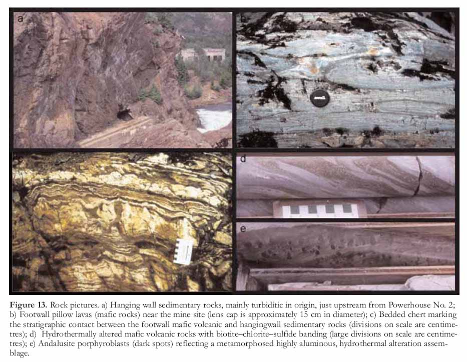
Figure 13. Rock pictures. a) Hanging wall sedimentary rocks, mainly turbiditic in origin, just upstream from Powerhouse No. 2; b) Footwall pillow lavas (mafic rocks) near the mine site (lens cap is approximately 15 cm in diameter); c) Bedded chert marking the stratigraphic contact between the footwall mafic volcanic and hangingwall sedimentary rocks (divisions on scale are centimetres); d) Hydrothermally altered mafic volcanic rocks with biotite–chlorite–sulfide banding (large divisions on scale are centimetres); e) Andalusite porphyroblasts (dark spots) reflecting a metamorphosed highly aluminous, hydrothermal alteration assemblage.GEOLOGY OF THE ANYOX PENDANT
Regional Setting
47 The Anyox Pendant (particularly the area between Anyox and Maple Bay, Fig. 2) is a Paleozoic to Mesozoic volcanic and sedimentary succession preserved as a roof pendant within the Tertiary Coast Plutonic Complex (Grove 1986). The pendant hosts four volcanogenic massive sulphide deposits, of which the Hidden Creek deposit is or was, by far, the largest.
48 The pendant is divided roughly into eastern and western parts. The eastern part, which hosts the massive sulfide deposits, consists of well-preserved volcanic strata of the Upper Triassic to Lower Jurassic Hazelton Group and is overlain by the sedimentary rocks of the Upper to Middle Jurassic Bowser Lake Group (Alldrick 2000; Figs. 2, 3). These rocks collectively have recognizable primary textures and clear stratigraphic relationships. In contrast, the western part of the pendant comprises interleaved intrusive and metamorphic rocks in which primary stratigraphic relationships are obscured and structural complexity is the norm. This western part is represented by "hornfelsed sedimentary rocks" in Figure 2 and by the "Clashmore metamorphic complex" (Evenchick et al. 1997; Evenchick and McNicoll 2001) in Figure 3; these rocks will not be discussed further in this paper.
49 In the eastern part of the pendant, mudrocks and sandstone turbidites (Fig. 13a) of the Bowser Lake Group stratigraphically overlie mafic volcanic rocks of the Hazelton Group, comprising massive to pillowed flows and volcanic breccias, massive flows and subvolcanic intrusions (Fig. 13b). In the Hidden Creek area, turbidite beds range from one to tens of centimetres in thickness, are massive and unsorted, and have rare grading. Near the stratigraphic lower contact with the mafic volcanic rocks, the amount of mudrocks increases and the turbidite beds are thinner (Macdonald et al. 1996). The turbidites consist mainly of silt- to sand-sized quartz and feldspar grains and contain black to brown argillaceous material (Macdonald et al. 1996). Impure limestone beds containing up to 30% clastic material are recognized and are also considered to be turbiditic in origin.
50 An interval of cherty rocks having alternating silica-rich and silica-poor layers, situated at the stratigraphic contact between the footwall mafic volcanic and hangingwall sedimentary successions, likely reflects a chemical precipitate deposited during a hiatus in volcanic activity prior to the onset of turbidite sedimentation (Fig. 13c). These rocks form an important strati-graphic marker and indicate the interval that is most prospective for volcanogenic massive sulfide deposits.
51 Both the footwall and hang-ingwall successions are metamorphosed. The sedimentary rocks are biotite grade and the mafic volcanic rocks have a chlorite–amphibole (actinolite–hornblende)–epidote, upper-greenschist metamorphic mineral assemblage. A contact metamorphic assemblage is developed locally with randomly oriented biotite, andalusite, muscovite and rare cordierite.
52 The hangingwall sedimentary succession shows coherent mappable folds. Both the Bonanza and Hidden Creek deposits are situated in regional anticlines. Evenchick et al. (2001) reported that the structural complexity increases to the west and down section towards the basal units within the turbidites, where folds become tighter and have shorter wavelengths near the contact with the mafic volcanic rocks. A strong penetrative fabric defined by an alignment of biotite and muscovite is preserved around the Hidden Creek deposit; crenulation cleavage is developed locally near the granite contacts.
Geologic Setting of the Anyox Deposits
53 Mineralization at Anyox is localized within tens of metres of the strati-graphic contact between mafic volcanic and sedimentary rocks. The compositions of the mafic volcanic rocks, which have been described by Smith (1993) and Macdonald et al. (1996), are consistent with their formation in a spreading-ridge setting (normal midocean ridge basalt or N-MORB for short) with a smaller subset related to melting of a relatively enriched source area (E-MORB). Mineralization and hydrothermal alteration occur near the contact between the mafic volcanic and sedimentary rocks but may be entirely within the mafic volcanic rocks, at the contact, or entirely within the sedimentary rocks, suggesting a long-lived hydrothermal system. The stratigraphic setting, alteration, mineralization, geo-chemistry of the mafic volcanic rocks, as well as the temperature and composition of fluid inclusions are consistent with the deposit forming in a sedimented spreading axis such as the Middle Valley on the northern Juan de Fuca Ridge, off the coast of British Columbia (Macdonald et al. 1996; Goodfellow and Peter 1994).
54 Although the mineral deposits have not been dated directly, recent geochronology on rocks of the eastern part of the Anyox Pendant have been able to constrain the age of sulfide deposition and provide regional geologic correlations (Evenchick and McNicoll 2001). Tuffaceous interflow sediment in the mafic volcanic rocks west of Anyox yielded a detrital zircon age of ca. 186 Ma, providing a maximum age of the mafic volcanic rocks. Evenchick and McNicoll (2001) also report well preserved late Bathonian ammonites from the upper sedimentary succession about 2 km stratigraphically above the mafic volcanic rocks. Collectively, these ages constrain the transition from mafic volcanism to clastic sedimentation, roughly the age of mineralization at Anyox, to latest Early Jurassic to earliest Middle Jurassic.
Hydrothermal Alteration
55 Alteration of the mafic rocks is generally expressed as biotite–chlorite–epi-dote–quartz-sulfide banding in the footwall proximal to the massive sulfide lenses at Hidden Creek (Fig. 13d). This banding is interpreted to reflect transposition of a metamorphosed chlorite–sericite alteration zone. In the hangingwall sedimentary succession, hydrothermally altered rocks are generally zoned from a core of quartz–chlo-rite to a distal quartz–sericite–pyrite alteration assemblage (Macdonald et al. 1996). Andalusite, and rarely cordierite, porphyroblasts (Fig. 13e) have been recognized in the sedimentary rocks proximal to the massive sulfide lenses around Hidden Creek. These meta-morphic minerals are common despite the generally low metamorphic grade, suggesting that they represent meta-morphism of a highly aluminous hydrothermal alteration assemblage.
56 Mass flux calculations for the volcanic and sedimentary rocks indicate a progressive loss of CaO + Na20 and gain in MgO + FeO, reflecting the breakdown of plagioclase and the formation of chlorite (Macdonald et al. 1996). Potassium has been added to the volcanic rocks, which is expressed as biotite. Immobile element ratios for the sedimentary rocks suggests that the detrital component is not derived from the underlying mafic volcanic rocks but must have come from a felsic, possibly cratonic, source (Macdonald et al. 1996).
VOLCANOGENIC MASSIVE SULFIDE DEPOSITS
57 The mineralization at Anyox belongs to a class of ore deposits called volcanogenic massive sulfide (VMS) deposits. These deposits are formed by submarine hydrothermal activity that precipitates sulfide minerals at or near the seafloor, mainly as sedimentary layers. Volcanogenic massive sulfide deposits are actively forming today in modern oceans from vents that are generally called "black smokers" because of the darkly coloured sulfide particles entrained in the discharging hydrothermal fluids. Volcanogenic massive sulfide deposits are found throughout the rock record and are valuable sources of copper, lead, zinc, gold, and silver.
58 As a deposit type, these ore bodies have been tremendously important in the economic development of Canada with important mines and mining districts in Bathurst, New Brunswick; Noranda, Québec; Kidd Creek, Ontario; Flin Flon, Manitoba; and Brittania and Anyox in British Columbia, to name a few. Although this deposit type has been mined for decades in Canada and world-wide for centuries, the progression of scientific thought on how VMS deposits formed is relatively new, having been strongly influenced by the discovery of active seafloor hydrothermal systems in the late 1970s using submersibles. Reviews by Sangster (1972), Solomon (1976) and Franklin et al. (1981, 2005), amongst others, discuss VMS deposits and the evolution of ideas on how these deposits form, and the current thinking on genesis.
Figure 14. Generalized geology of the Hidden Creek mine area showing the distribution of the major rock units and the main sulfide lenses, projected to surface. Geology after Davis et al. (1993); Nelson (1935).
Display large image of Figure 14
Display large image of Figure 15
59 When Anyox was in production, VMS type deposits were unknown. They were generally considered to be in large structurally controlled shear zones or a replacement of a favourable host rock, and genetically related to granitic rocks. As a result, the bulk of the historic work at Anyox was done without a modern understanding on how these deposits formed, which naturally influenced how exploration and development proceeded. However, from the perspective of the mine geologist and engineer, these questions were academic as their job was to mine sulfides and produce copper. How and where these deposits formed were questions that could not be answered until better analytical methods and submersibles became available, many decades later.
Mineralization
Hidden Creek
60 The bulk of the Anyox production came from large massive sulfide lenses within the Hidden Creek deposit (Fig. 3). Over 21.73 million tonnes of copper ore at an average recovered grade of 1.68% Cu, 10.8 g/t Ag and 0.20 g/t Au, were concentrated and smelted between 1914 and 1935 to produce 321 546 tonnes of copper, 206 309 kg (6.6 million oz) of silver, and 3773 kg (121 300 oz) of gold (Minfile 103P 021). Although the deposits also contained Zn and Pb, these metals were not recovered in the smelting process. The original Imperial units have been retained in the following descriptions of the gold and silver grades as well as the mine levels, which were designated in feet above sea level (asl).
61 The Hidden Creek deposit consists of a number of sheet-like massive sulfide lenses and associated stockwork mineralization, all of which have been complexly folded. The main lenses or orebodies, which represent over 95% of the mine production, are labelled Nos. 1 through 5 (Figs. 14, 15). The Nos. 1, 4 and 5 lenses are hosted within sedimentary rocks, whereas the Nos. 2 and 3 lenses are hosted by mafic volcanic rocks, described by Dolmage (1922) as "heavily mineralized green schist". The No. 6 lens occurs at the contact between the mafic and sedimentary successions. Mineralization occurs both stratigraphically above and below the mafic volcanic–sedimentary rock contact, generally within tens of metres of the contact.
62 The Hidden Creek deposit is composed mainly of pyrite, pyrrhotite and chalcopyrite. There is a strong association between chalcopyrite and pyrrhotite, whereas the massive pyrite intervals are barren or only weakly cupriferous. The orebodies are zoned with almost pure sulfides in the upper parts and highly siliceous, lower grade pyritic material in the lower parts (Nelson 1948). In addition to pyrite, pyrrhotite, chalcopyrite, and sphalerite, Dolmage (1922) noted the presence of magnetite, arsenopyrite, native silver, and possible argentite, and mentioned that Bancroft had found small amounts of galena. The gangue mineralogy of the massive sulfides tends to be sucrosic silica. Massive intervals of coarse-grained calcite, with interstitially disseminated pyrite and pyrrhotite, were intersected locally in exploration drilling.
63 At the Hidden Creek deposit, the sediment-hosted Nos. 1 and 5 lenses show a zoned alteration pattern from a quartz–chlorite–pyrrhotite core to a margin of quartz–sericite–pyrite (Macdonald et al. 1996). Chalcopyrite is associated with pyrrhotite in the core, whereas sphalerite is associated with pyrite on the margins. Massive calcite lenses are associated with massive sulfides and calcite is present throughout the sedimentary succession. Biotite in the alteration assemblage at Hidden Creek is probably the result of regional metamorphism of K- and Mg-rich alteration minerals such as sericite and chlorite.
64 The detailed mine geology is complicated by numerous igneous dikes. Bancroft (1918) reported that 56 dikes of variable compositions were mapped on the 385 level of the Hidden Creek Mine. Most dikes are conformable in strike and dip and are less than a metre wide, although a considerable number are 1 to 8 m wide, and a few are 8 to 12 m wide. Some extend for hundreds of metres and maintain a constant strike and uniform width but many are extremely irregular. Fifty-six dikes, of a variety of compositions, were mapped on the 385 level of the Hidden Creek mine. None of the dikes is foliated and all are post-ore and post-faulting. This complex igneous geology likely reflects the fact that the deposits are hosted by a roof pendant in the Coast Plutonic Complex, which was subjected to many episodes of igneous activity from the Late Triassic to Tertiary.
65 The dimensions of the sulfide lenses (Figs. 14, 15) are impressive. Dolmage (1922) reported that lens No. 1 cropped out for a length of 1000 ft at an average elevation of 700 ft asl and was localized at the contact between the mafic volcanic and sedimentary rocks. Underground the lens was about 450 m long and 30 to 40 m in width, and was followed down to 40 m below sea level by diamond drilling. At depth, there is little, if any, decrease in the copper content, which averaged about 2%. The massive sulfide lenses commonly contained ribbon-like bands or large irregular masses of argillite (mudrock), which had been silicified and mineralized. Although the Anyox mineralization contained little zinc on average, sphalerite (an ore of zinc) was locally abundant. The highest copper grades were typically in the siliceous zones, whereas the lowest concentrations of copper were in the large tonnages of massive pyrite. Dolmage (1922) noted that some massive sulfides in lenses Nos. 1, 4 and 5 (thought to have formed by replacement) generally display fine banding "which represents the original banding of the argillites". The cherty, siliceous zone at the contact between the mafic volcanic and turbiditic sedimentary rocks was called "silicified green schist".
66 Dolmage (1922) reported that lens No. 2 cropped out at about 800 ft asl and plunged gently to the north (Figs. 14, 15). Both the length and width of the sulfide lens decreased quite rapidly with depth. On the 630 level, the high-grade portion measured 160 by 80 m. On the 385 level, the corresponding dimensions decreased to 85 and 45 m, respectively. High grade ore was followed with drilling down to the 290 level. Dolmage (1922) interpreted No. 3 lens to be the faulted offset of the No. 2 lens and concluded that they "have developed through mineralization and silicification of schistose zones in the altered porphyrite or greenstone near its contact with the argillites".
67 The No. 4 lens (the pyrite body) was triangular in shape with a length on the 760 level of about 180 m. A considerable portion of this lens was solid pyrite with low copper values.
68 Dolmage (1922) reported that lens No. 5 plunged to the north (Figs. 14, 15). On the 385 level, the practically solid sulfide portion had a length of nearly 150 m and an average width of about 33 m. Below the 150 level, the volume of massive sulfide decreased rapidly as it passed into siliceous ore containing disseminated sulfides at depth, especially toward its northern end. This orebody was richer in copper and carried somewhat higher values in precious metals and zinc than the others. Where it was intersected on the 285 level, much of the lens assayed from 8 to 12 % Cu. Lens No. 6 had a length of about 150 m and a maximum width of about 35 m, and dipped nearly vertically. He concluded that lens No. 6 had "developed at the immediate contact (volcanic-sediment) and involved the replacement of both schistose greenstone and argillite".
69 Dolmage (1922) concluded that variations in the average compositions of the different orebodies were dependant upon whether they had developed through the replacement of argillites or of green schists. Although not in agreement with modern concepts, he recognized the strong strati-graphic control on mineralization and the broad district zoning in the sulfide lenses.
Bonanza, Redwing and Double Ed Deposits
70 The Bonanza, Redwing and Double Ed deposits are situated south of Hidden Creek and also within the Anyox Pendant (Fig. 3). All three deposits are hosted by volcanic rocks near the contact between the volcanic and sedimentary rocks (Grove 1986; Minfile 103P 023, 024 and 025, respectively).
71 The Bonanza deposit occurs in mafic volcanic rocks, comprising basaltic tuffs and minor intercalated mudrocks that have been altered to an assemblage of chlorite–sericite and have a strong penetrative fabric. The mineralized lenses are composed of massive to disseminated pyrite– pyrrhotite with lesser amounts of chalcopyrite and sphalerite. Gangue minerals consist of quartz, sericite, chlo-rite, actinolite, tremolite, hornblende and calcite (Minfile 103P 023). Production from the Bonanza deposit between 1928 and 1935 totalled 0.66 million tonnes at an average recovered grade of 2.18% Cu, 13.3 g/t (0.47 oz/ton) Ag, and 0.13 g/t (0.005 oz/ton) Au.
72 Redwing and Double Ed deposits are undeveloped prospects. Both have similar grades to the Hidden Creek and Bonanza deposits, are localized on the west limb of the Rambler (Hidden Creek) syncline and are hosted by mafic volcanic rocks (Grove 1986).
Other Mineral Deposits in the Anyox Pendant
73 A number of quartz veins occur within the Anyox Pendant. Sharp (1980) and Alldrick (1986) recognized two distinct styles of quartz veins, both of which are hosted in the sedimentary succession. Type 1 veins consist of white bull-quartz that may contain base-metal sulfides and gold. Type 2 veins are localized in the lower intervals of the sedimentary succession along fold axes. Alldrick (1986) speculated that these veins represent remobilized silica from the chert marker unit, and that the distribution and mineralogy of these veins may indicate proximity to massive sulfide lenses.
74 During mining at Anyox, large quartz vein networks were mined for silica smelter flux. These include the Granby Point, Golskeish, Gold Leaf, and Rambler quartz vein deposits (Minfile 103P 022, 027, 028, 226, respectively). These veins are mainly hosted within the turbidite succession in the hangingwall of the massive sulfides and are Type 1 of Alldrick (1986). The use of the auriferous quartz veins as a smelter flux added gold to the recovered metals from the smelter. As a result the published recovered gold grades for Hidden Creek and Bonanza may not accurately reflect the gold content of the massive sulfide lenses because there is an unknown contribution from the silica flux. Dolmage (1922) gave crude average gold grades of between 0.002 and 0.13 oz/ ton (0.07 - 4.5 g/t Au) for high-grade sulfide lenses and 0.002 and 0.004 (0.07 -0.14 g/t Au) for low-grade lenses.
75 Porphyry molybdenum occur-rences have been found locally within the Eocene intrusive rocks The Moly Mack and Black Bear prospects (Min-file 103P 228 and 031) are associated with quartz monzonite stocks that have been intruded into supracrustal rocks of the Anyox Pendant. These rocks are variably altered to kaolin and sericite and host quartz stockwork style mineralization (Minfile 103P 228).
IMPORTANCE OF ANYOX
Socio-eeconomic Significance
76 Anyox played an important role in the development of northwestern British Columbia. It also enabled the Granby Consolidated Mining, Smelting and Power Company Ltd. to remain a viable producer after 1914, when copper ore from its original Phoenix Mine was exhausted. This company played a very significant role in shaping not just the growth of the province, but also the practice of mining.
Granby Mining Company Limited
77 Mining companies come and mining companies go – some leave legacies whilst others just leave. Granby Consolidated Mining, Smelting and Power Company Ltd. left a legacy. This company developed some of the largest mines in the province and its smelter at Grand Forks was, at one time, the largest non-ferrous smelter in the British Empire, and the second largest in the world. Low copper prices and low reserves twice pushed Granby to the brink of liquidation, and twice the company battled back to solvency, regaining its stature as a major contributor to the economy of British Columbia.
78 The deposit that launched Granby was the Phoenix Mine near Greenwood in south-central British Columbia. The first claims at Phoenix were staked on July 15, 1891 by Henry White (Knob Hill Mine) and Matthew Hatter (Old Ironsides Mine). Initially, the claims did not generate much excitement because the copper grade was relatively low for the times, two other booms at Rossland and Slocan were drawing attention, and the nearest railroad was 120 km miles away. However, once the copper ore was discovered to be self-fluxing, meaning it could be treated in an affordable manner, the level of interest soared. In 1896, J.F.C. Miner, President of the Granby Rubber Company, of Granby, Quebec, together with mining promoter Jay P. Graves and A.L. Little from Spokane, Washington, formed the Miner-Graves Syndicate and began purchasing claims. In 1901, they consolidated all of the Syndicate’s companies and properties under a new company, Granby Consolidated Mining, Smelting and Power Company, Limited. The corporate title was shortened to Granby Mining Company Limited in 1963.
79 The company was extremely fortunate in, and supportive of, the mechanical and electrical aptitude and ingenuity of its employees. This scope of creativity, combined with the ability to apply economies of scale to its Phoenix operations, enabled Granby to lower operating costs from $4.77 per ton to $2.39 between 1901 and 1913.
80 Granby’s contributions to the modernization of mining include the introduction of open pit mining methods. In 1903, the Old Ironsides Mine became one of the first open pit mines in Canada. The self-dumping Granby car was developed at Phoenix and introduced in 1905. Another time- and cost-saving invention was the drill sharpening machine, which reduced the number of blacksmiths and forges required. The Grand Forks smelter was designed and built by A.B.W. Hodges, who also invented the automatic furnace charger that reduced the time and manpower formerly required for this task.
81 The company’s input to the development of B.C. is recognized in perpetuity by the number of significant geographical features that bear its name. Besides Granby Bay in Observatory Inlet, there is Granby River, which flows south for 100 km between the Midway and Christina mountain ranges before reaching Grand Forks and merging with the Kettle River, and Granby Provincial Park, a 40 845 ha park that surrounds the upper Granby River, which was opened in 1995.
82 In the early 1970s, when Granby was in its heyday shipping iron and copper concentrates to Japan from the Jedway Mine on Moresby Island and copper–gold–silver concentrates from the Phoenix Mine and the Granisle Mine, a controlling interest in its shares was acquired by Rene Wolcott, President of the Pacific Clay and Pipe Company of Los Angeles. Wolcott was eventually forced to sell, which opened the door for Zapata Corporation of Houston, Texas to acquire 90% of Granby. When the Canadian Foreign Investment Review Act prevented Zapata from purchasing the other 10%, and it was unable to acquire Noranda Inc.’s Bell Copper Mine near the Granisle Mine or the Equity Silver Mine near Houston, B.C., it sold Granby to Noranda in 1979, marking the end of the Granby story.
Geological Significance
83 In the past, regional geologic correlations of the Anyox Pendant have been problematic due to a lack of geochronology and modern regional mapping. Various correlations have been proposed although most of these had little scientific basis; however, recent geologic investigations by the Geological Survey of Canada seems to have solved this problem. Evenchick et al. (1997) correlated the hangingwall sedimentary succession with the Bowser Lake Group, based on lithologic similarities of the eastern Anyox Pendant with turbidites of the contiguous Bowser Lake Group 8 km farther east, which is supported by recent geochronology work (Evenchick and McNicoll 2001). Collectively, these lines of evidence suggest that the mafic rocks are either correlative with the Hazelton Group, which is part of the Stikine (Stikinia) Terrane of the Intermontane Belt (Struik and MacIntyre 2001), or coeval strata of another terrane. However, the similar age and nature of magmatism and sedimentary rocks strongly support the correlation of the eastern part of the Anyox Pendant with the Hazelton Group.
84 Stikinia is well endowed with VMS deposits (Sherlock et al. 1996; Fig. 1). At the northwestern end of this terrane, the Tulsequah Chief and nearby Big Bull VMS deposits are hosted by Lower Mississippian felsic volcanic rocks, in a dominantly mafic volcanic succession. In the Iskut River area the past producing Granduc VMS deposit is hosted in complexly deformed mafic volcanic and sedimentary rocks, similar in style to Anyox, but correlated with the older Triassic Stuhini Group (Childe et al. 1994). The Eskay Creek deposit in the Iskut River area consists of precious metal-rich sulfide-sulfosalt lenses in argillite and veins in a footwall rhyolite. It is hosted in the upper part of the Hazelton Group, where fossil evidence from the hangingwall rocks and U-Pb geochronology of the footwall rhyolites suggest a middle Jurassic age for the mineralization (Childe 1996). Although much different in style of mineralization and host rocks, Anyox and Eskay Creek appear to have formed at a similar stratigraphic positions near the top of the Hazelton Group. Correlations between Anyox and Eskay Creek may stimulate additional phases of exploration and possibly further chapters in the history of Anyox.
85 Although not directly correlatable, in terms of terrane affiliations, the Anyox deposits are similar in many respects to the Windy Craggy deposit that occurs within the Alexander Terrane of the Insular Belt (Peter and Scott 1999), in northern British Columbia. This deposit is a major accumulation of massive sulfides in an Upper Triassic succession of fine to medium grained clastic sedimentary rocks and associated mafic volcanic rocks and mafic sills (Peter and Scott 1999). At Windy Craggy, sediment-hosted massive sulfides lenses and stockwork veins crosscut volcanic and sedimentary strata. A chert–calcite interval that overlies the massive sulfides is interpreted by Peter and Scott (1999) as a chemical sediment largely derived from hydrothermal fluids. Windy Craggy has a similar mineralogical zoning to Anyox with a core area containing pyrrhotite–chalcopyrite and peripheral areas with sphalerite–pyrite.
ACKNOWLEDGEMENTS
The authors wish to acknowledge the generous assistance of those who reviewed and contributed their time and expertise to the development of this article. In particular, we wish to thank reviewers Scott Swinden and Dani Alldrick as well as GMCC series editors Bob Cathro and Steve McCutcheon for constructive comments on earlier versions of this article. In addition, Dani Alldrick was invaluable in his assistance in providing archival excerpts from the Canadian Mining Journal and background information from his personal experience with the Anyox site. We also thank Bob Cathro for soliciting the article in the first place; John Jewitt, former President, Granby Mining Company, for sharing his memories and providing material from his private library; Diane Thompson, Head Librarian, Natural Resources Canada for providing leads to literature on Anyox; and Moss Management and Anyox Hydro Electric Corp. for providing information on and photographs of the Anyox Dam. Finally, the authors wish to thank Sylvia McLean and Judy Tracy for kindly sharing images from their family albums and Andrew Webber, Regional District Kitimat-Stikine, BC, for his assistance in arranging the use of the Tracy family images.REFERENCES
Alldrick, D.J., 1986, Stratigraphy and structure in the Anyox area (103P/5): British Columbia Ministry of Energy, Mines and Petroleum Resources. Geological Fieldwork 1985, paper 1986-1, p. 211-216.
Alldrick, D.J., 2000, Geology of the Anyox Mining Camp, British Columbia (103P): British Columbia Ministry of Energy, Mines and Petroleum Resources Geoscience. Map 2000-28, scale 1:20,000.
Bancroft, J. A., 1918, Preliminary report on the geology of the Anyox map-area, which includes the Hidden Creek and Bonanza copper deposits: unpublished report, 59 p.
Carter, N.C., and Grove, E.W., 1972, Geologic compilation of the Stewart, Anyox, Alice Arm and Terrace areas: British Columbia Department of Mines and Petroleum Resources. Preliminary Map, No. 8.
Childe, F.C., Barrett, T.J., and McGuigan, P., 1994, The Granduc VMS deposit northwestern British Columbia: U-Pb ages and Pb isotope relations: Geological Society of America, Program with abstracts p. A-381.
Childe, F.C., 1996, U-Pb geochronology and Nd and Pb isotope characteristics of the Au-Ag rich Eskay Creek volcanogenic massive sulphide deposit, British Columbia: Economic Geology, v. 91, p. 1209-1224.
Davis, J.W., and Aussant, C.H., 1994, Geological, geochemical and geophysical report on the Anyox property, Skeena Mining Division: Unpublished Report for TVI Copper Inc. British Columbia Ministry of Energy, Mines and Petroleum Resources, Assessment Report 23582, 83 p.
Davis, J.W., Aussant, C.H., and Chisholm, R.E., 1993, Diamond drilling, geo-chemical and geophysical report on the Anyox property, Skeena Mining Division, Latitude 55°25’ North, Longitude 129°50’ West, NTS 1030-P/5 W, British Columbia: Unpublished Report for TVI Copper Inc. 103 p.
Dolmage, V., 1922, Coast and islands of British Columbia between Douglas Channel and the Alaskan boundary: Geological Survey of Canada, Summary Report, Part A, p. 9-23.
Dunn, R., 1924, Granby Consolidated: Canadian Mining Journal, Business Information Group, Toronto, Ontario, p. 200-209.
Evenchick, C.A., and McNicoll, V.J., 2001, Recent advances in geological framework and correlations in the Anyox Pendant and Georgie River area, northwestern British Columbia, and their implications for mineral exploration: Geological Survey of Canada, Open File 4164, 33 p.
Evenchick, C.A., and Holm, K., 1997, Bedrock geology of the Anyox Pendant and surrounding areas, Observatory Inlet (103P/5), and parts of 103P/12 and 103O/9 map areas. In Current Research 1997-A: Geological Survey of Canada, p. 11-20.
Evenchick, C.A., McNicoll, V.J., Holm, K., Alldrick, D.J., and Snyder, L.D., 1997, Geology, Anyox Pendant and surrounding areas in Observatory Inlet (103P/5) and parts of Hastings Arm (103P/12), 103O/8,9: Geological Survey of Canada, Open File 3454, scale 1:50,000.
Flewin, J., 1924, Hidden Creek: Canadian Mining Journal, Business Information Group, Toronto, Ontario, p. 209-210.
Franklin, J.M., Lydon, J.W., and Sangster, D.F. 1981, Volcanic-associated massive sulphide deposits: Economic Geology, 75th Anniversary Volume, v. 75, p. 485-627.
Franklin, J.M., Gibson, H.L., Jonasson, I.R., and Galley, A.G., 2005, Volcanogenic-massive sulphide deposits: Economic Geology 100th Anniversary Volume, v. 100, p. 523-560.
Goodfellow, W.D., and Peter, J.M., 1994, Geochemistry of hydrothermally altered sediment, Middle Valley, northern Juan de Fuca Ridge, in M.J. Mottl, M.J., Davis, E.E., Fisher A.T., and Slack, J.F., eds., Proceedings of the Ocean Drilling Program: Scientific results, Leg 139, p. 207-289.
Griffin, B., 2002, Mining the North Coast: A Ghost Town’s Past, Discovery: Magazine of the Royal British Columbia Museum, Victoria, BC, v. 29, no. 5.
Grove, E.W., 1986, Geology and mineral deposits of the Unuk River- Salmon River – Anyox area: British Columbia Ministry of Energy, Mines and Petroleum Resources, Bulletin 63, 152 p.
Harrison, D., and McKinley, S., 2007, Technical report on the Coastal Copper project, Anyox Area. Northwestern British Columbia, Canada: Skeena Mining Division, 103P/05. British Columbia Assessment Report, June 2007, 110 p.
Loudon, P., 1973, The Town that Got Lost: Morris Printing Company Ltd., Victoria, B.C.
Macdonald, R.W.J., 1999, Geology and lithogeochemistry at the Hidden Creek massive sulphide deposit, Anyox, west central British Columbia: Unpublished M.Sc. thesis, The University of British Columbia, Vancouver, B.C., 173 p.
Macdonald, R.W.J., Barrett, T.J., and Sherlock, R.L., 1996, Geology and lithogeochemistry at the Hidden Creek massive sulphide deposit, Anyox, west-central British Columbia: Exploration and Mining Geology, v, 5, no. 4, p. 369-398.
Minfile 103P 021; Hidden Creek, BC Ministry of Energy and Mines, Minfile digital data, posted May 7, 2007. [http://minfile.gov.bc.ca/summary.asp x?minfilno=103P++02], accessed March, 2008.
Minfile 103P 022; Granby Point, BC Ministry of Energy and Mines, Minfile digital data, posted Sep. 13, 2007. [http://minfile.gov.bc.ca/summary.asp x?minfilno=103P++022], accessed March, 2008.
Minfile 103P 023; Bonanza, BC Ministry of Energy and Mines, Minfile digital data, posted Jan. 31, 1989. [http://minfile.gov.bc.ca/summary.asp x?minfilno=103P++023], accessed March, 2008.
Minfile 103P 024; Redwing, BC Ministry of Energy and Mines, Minfile digital data, posted Jan. 30, 1989. [http://minfile.gov.bc.ca/summary.asp x?minfilno=103P++024], accessed March, 2008.
Minfile 103P 025; Double Ed, BC Ministry of Energy and Mines, Minfile digital data, posted Jan. 30, 1989. [http://minfile.gov.bc.ca/summary.asp x?minfilno=103P++025], accessed March, 2008.
Minfile 103P 027; Golskeish, BC Ministry of Energy and Mines, Minfile digital data, posted Jan. 31, 1989. [http://minfile.gov.bc.ca/summary.asp x?minfilno=103P++027], accessed March, 2008.
Minfile 103P 028; Gold Leaf, BC Ministry of Energy and Mines, Minfile digital data, posted Jan. 29, 1989. [http://minfile.gov.bc.ca/summary.asp x?minfilno=103P++028], accessed March, 2008.
Minfile 103P 031; Blackbear, BC Ministry of Energy and Mines, Minfile digital data, posted April 7, 1997. [http://minfile.gov.bc.ca/summary.asp x?minfilno=103P++031], accessed March, 2008.
Minfile 103P 226; Rambler, BC Ministry of Energy and Mines, Minfile digital data, posted Jan 29, 1989. [http://minfile.gov.bc.ca/summary.asp x?minfilno=103P++226], accessed March, 2008.
Minfile 103P 228; Moly May, BC Ministry of Energy and Mines, Minfile digital data, posted Jan 31, 1989. [http://minfile.gov.bc.ca/summary.asp x?minfilno=103P++228], accessed March, 2008.
Minfile 103P 257; Anyox Slag heap, BC Ministry of Energy and Mines, Minfile digital data, posted Jan 6, 1999 [http://minfile.gov.bc.ca/summary.asp x?minfilno=103P++257], accessed March, 2008.
Nelson, N.E., 1935, The Hidden Creek ore-bodies: Transactions of the Canadian Institute of Mining and Metallurgy, Montreal, p. 349-357.
Nelson, N.E., 1948, Hidden Creek mine, in Gilbert, G. ed., Structural Geology of Canadian Ore Deposits, Congress Volume: Canadian Institute of Mining and Metallurgy, Geology Division, Mercury Press, Montreal, p. 66-77.
Peter, J M., and Scott, S D., 1999, Windy Craggy, northwestern British Columbia: the world’s largest Besshi-type deposit, Volcanic-associated massive sufide deposits: processes and examples in modern and ancient settings, in Barrie, C.T., and Hannington, M.D., eds., Reviews in Economic Geology, v. 8, p. 261-295.
Sangster, D.F., 1972, Precambrian volcanogenic massive sulphide deposits in Canada: A review: Geological Survey of Canada, Paper, 72-22, 44 p.
Sharp, R.J., 1980, The geology, geochemistry and sulphur isotopes of the Anyox massive sulphide deposits: M.Sc. thesis, University of Alberta, Edmonton, AB., 211 p.
Sherlock, R.L., Barrett, T.J., Thompson, J.F.H., Macdonald, R.W.J., McKinley, S.D., Roth, T., Sebert, C. and Childe, F.C., 1996, Geology of volcanogenic massive sulphide deposits in the Cordilleran of British Columbia, Canada, in Coyner, A.R., and Faher, P.L., eds., Geology and Ore Deposits of the American Cordillera: Geological Society of Nevada Proceedings, Reno/Sparks Nevada, p. 1253-1280.
Smith, A.D., 1986, Isotopic studies of Terrane I, south-central British Columbia: Ph.D. thesis, University of Alberta, Edmonton, AB., 193 p.
Smith, A.D., 1993, Geochemistry and tec-tonic setting of volcanics from the Anyox mining camp, British Columbia: Canadian Journal of Earth Sciences, v. 30, p. 48-59
Solomon, M., 1976, Volcanic-massive sulphide deposits and their host rocks - a review and explanation, in Wolf, K.H., ed., Handbook of Stratabound and Stratiform Ore Deposits, Elsevier, Amsterdam v. 2, p. 21-54.
Struik, L.C., and MacIntyre, D.G., 2001, Introduction to the special issue: The Nechako NATMAP Project of the Central Canadian Cordillera: Canadian Journal of Earth Sciences, v. 38, p. 485-494.
Sun Directories 1935, The British Columbia and Yukon Directory, 1935 edition: Sun Directories Limited, Vancouver.
ENDNOTES
