Remote Predictive Mapping 1.
Remote Predictive Mapping (RPM): A Strategy for Geological Mapping of Canada’s North
E.M. SchetselaarGeological Survey of Canada 601 Booth Street, Ottawa, ON, Canada K1A 0E9
erschets@nrcan.gc.ca
J.R. Harris
Geological Survey of Canada 601 Booth Street, Ottawa, ON, Canada K1A 0E9
T. Lynds
Geological Survey of Canada 601 Booth Street, Ottawa, ON, Canada K1A 0E9
E.A. de Kemp
Geological Survey of Canada 601 Booth Street, Ottawa, ON, Canada K1A 0E9
Submitted November 1, 2007. Accepted as revised, March 28, 2008
SUMMARY
Remote Predictive Mapping (RPM) techniques are being developed and refined by the Geological Survey of Canada for mapping Canada’s North. Remote Predictive Mapping should be considered an integral part of the geological mapping process designed to involve compilation, and re-compilation of data derived from existing geological maps, aerial photographs, satellite imagery, and airborne geophysical data. Predictive geological maps may be iteratively revised and upgraded to publishable geological maps by integrating remotely sensed data with newly acquired field and laboratory data, as RPM techniques are progressively tested and insight evolves. A predictive map, produced without collection of new, field-based data, may also serve as a first-order geologic map in areas where field-based studies cannot be accomplished due to expense of field access or remoteness. As a welcome consequence of adopting RPM into the normal work flow of any mapping or exploration project, there will, by necessity, be greater participation and integration of expertise of field geologists, geophysicists, Geographic Information System (GIS) and remote sensing specialists. Significantly, RPM also encourages geoscience organizations to make full use of all available geoscience data.This paper outlines a strategy for RPM and provides processing and interpretation examples based on a variety of geoscience data and interpretation techniques to be employed for geologic mapping.
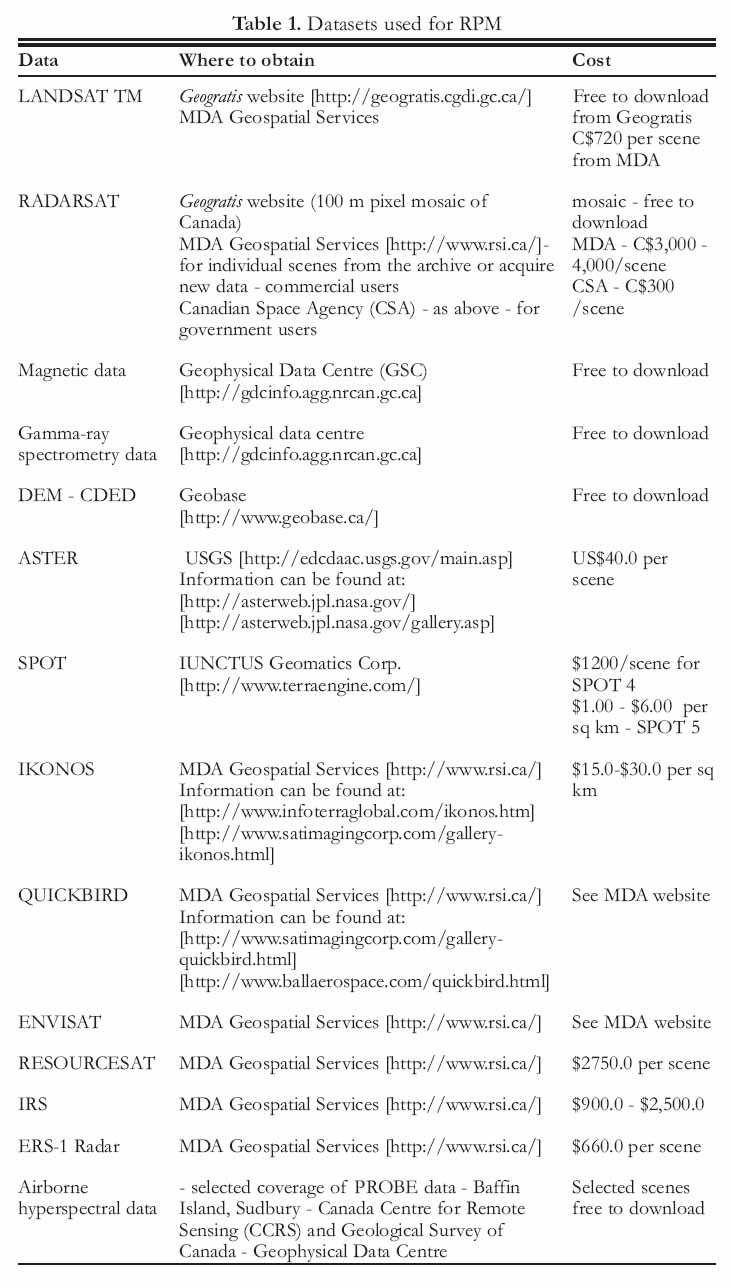
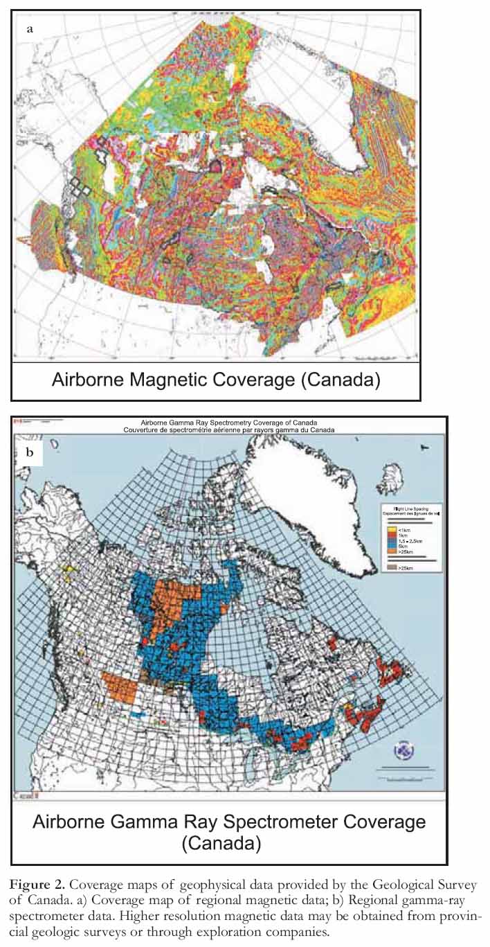
SOMMAIRE
La Commission géologique du Canada développe et raffine des techniques de télécartographique prédictive (TCP) pour cartographier du Nord canadien. La télécartographie prédictive doit être perçue comme une composante intégrée d’un processus de cartographie géologique de compilation et de recompilation de données extraites de cartes géologiques, de photographies aériennes, d’imageries satellitaires, et de géophysiques aéroportées existantes. Les cartes géologiques prédictives peu-vent ainsi être révisées, mises à jour et publiées selon une approche itérative intégrant les données de télédétection avec les données de terrain et de laboratoire nouvellement acquises, au gré de l’évolution et du raffinement des techniques de TCP. Dans les cas de régions trop éloignées, ou parce que les coûts d’établissement de cartes géologiques de base régulières seraient prohibitifs, la TCP peut aussi être utilisée pour produire une carte géologique de base. D’entrée de jeu, on réalise que l’adoption de la TCP dans la routine de production normale de tout projet de cartographie ou d’exploration permettra, en soi, une meilleure prise en compte et une meilleure intégration des savoirs-faires des géologues de terrain, des géophysiciens et des spécialistes de la télédétection et des systèmes d’information géographique (SIG). Par sa nature même, la TCP permet aux organisations géoscientifiques de faire plein usage de toutes les données géoscientifiques dont elles disposent.Le présent article définit une stratégie de TCP et décrit des exemples de traitement et d’interprétation d’une variété de données géoscientifiques et de techniques d’interprétation utilisables pour la production de cartes géologiques.
INTRODUCTION
1 Due to its vast territory and world-class mineral and energy potential, Canada’s North requires efficient and rapid methods to upgrade its geo-science knowledge base; an important part of this endeavour involves updating geological map coverage. Whereas in the past, the coverage and publication of traditional geological maps (of a limited region) demanded many years of fieldwork, more time-efficient approaches of mapping larger regions within shorter time spans are now required. As a result, since 2004, an approach termed, ‘Remote Predictive Mapping (RPM)’ has been implemented in pilot projects by the Geological Survey of Canada. Remote Predictive Mapping is an integrated geological mapping approach, in which existing geological map data are re-compiled on the basis of the interpretation of air-photos, satellite imagery and airborne geophysical data, before and during fieldwork. Remote Predictive Mapping facilitates time-efficient production of consistent current digital geological databases over large geographical regions.
2 Remote Predictive Mapping is not an entirely new philosophy for geologic mapping. Geologists have long assembled diverse layers (primarily airphotos and aeromagnetic contour maps) of geoscience data to study the relationships between each spatial pattern to further resource exploration and mapping endeavours. In the past, this has been accomplished by using an "analog" approach forcing maps printed on mylar to be portrayed on a uniform map scale on a light table. However, with the increasing availability of digital datasets and the routine use of Geographic Information Systems (GIS), the task of studying relationships between data and producing innovative maps to assist field mapping has become easier and more versatile. In contrast to the "light-table" approach, GIS allows maps and image data to be combined, overlaid and manipulated at any scale using any combination of layers that can be subject to any integrated enhancement. Remote Predictive Mapping comprises the compilation and interpretation (visual or computer assisted) of a variety of geoscience data to produce predictive maps, containing structural, lithologic, geophysical and surficial information for the geologist before s/he actually begins field work. Predictive geological maps may be iteratively revised and upgraded to publishable geological maps on the basis of evolving insight by repeatedly integrating newly acquired field and laboratory data in the interpretation process. The predictive map(s) can also serve as a first-order geologic map in areas where field mapping is not feasible. The fundamental difference between RPM and traditional field mapping is that in the latter the compilation of units away from field control (current and legacy field observations) is largely based on geological inference, while in RPM this geological inference is repeatedly tested and calibrated against remote-sensing imagery1.
3 A predictive map does not represent geologic truth but rather a best estimate of what an area may represent on the ground, based on the signatures derived from the interpreted data (geophysical, geochemical, remotely-sensed). For that matter, even a traditionally produced geologic map may not represent the geologic truth as all maps, no matter how they are produced, may contain spatial and classification errors. Thus, geological features of a predictive map do not necessarily correspond to how these features would be classified in the field by a geologist. At the category level, the geological term attached to a unit or structural feature may even turn out to be incorrect; yet at the detection level, the identified feature may correspond to a hitherto unrecognized map unit or structure that can be targeted for follow-up fieldwork.
4 The nature, variety and quality of remotely sensed data, together with the desnity and quality of field data and the derived interpretations from each, are obviously key factors to what extent predictive maps resemble the geological patterns obtained by field mapping. Another factor is the nature of the geologic terrane being mapped because different datasets and associated processing and enhancement techniques will vary depending on the bedrock, surficial and topographic environments.
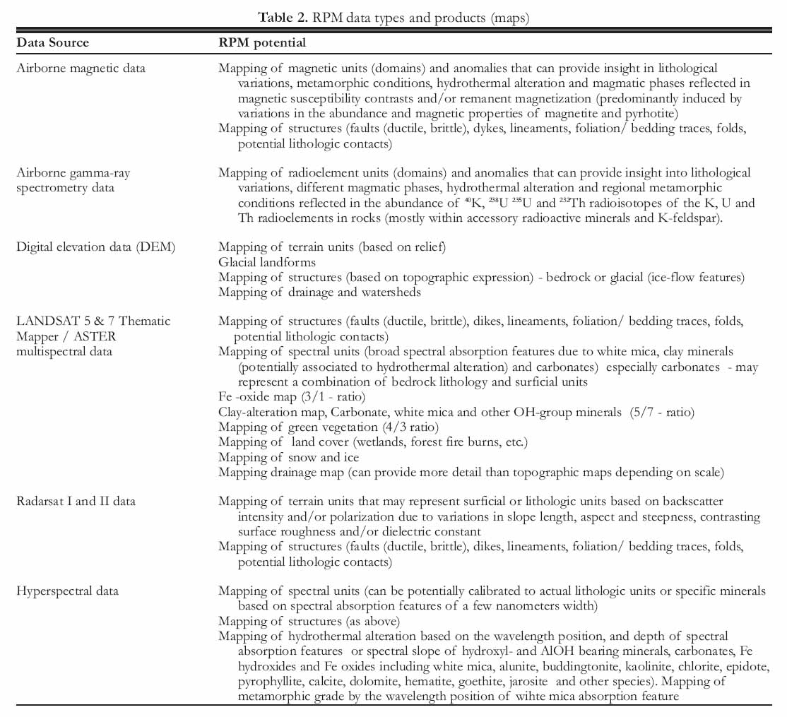
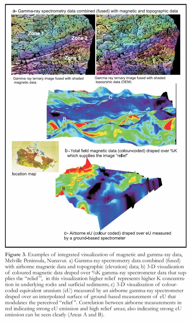
5 A remote predictive map can assist the geologist in a number of ways:
- Predicting areas that appear to be characterized by more complex and spatially heterogeneous geological patterns thus focusing and prioritizing field work; similarly, areas of more homogeneous signatures and simpler patterns can be identified that may require less field work to geologically calibrate.
- Predicting map units tentatively assigned to rock types and/or geological formations (bedrock and surficial). This is based on establishing critical relationships between imaged physical properties (magnetic susceptibility, density, gamma-ray spec-trometry, spectral reflectance, radar backscatter) and bedrock/surficial units defined by field mapping.
- Predicting physical structures/attributes (e.g. foliation traces, faults, dikes, lineaments, glacial-flow directions, etc.). The information can be used in advance of field work to supplement field observations or as stand-alone geologic data.
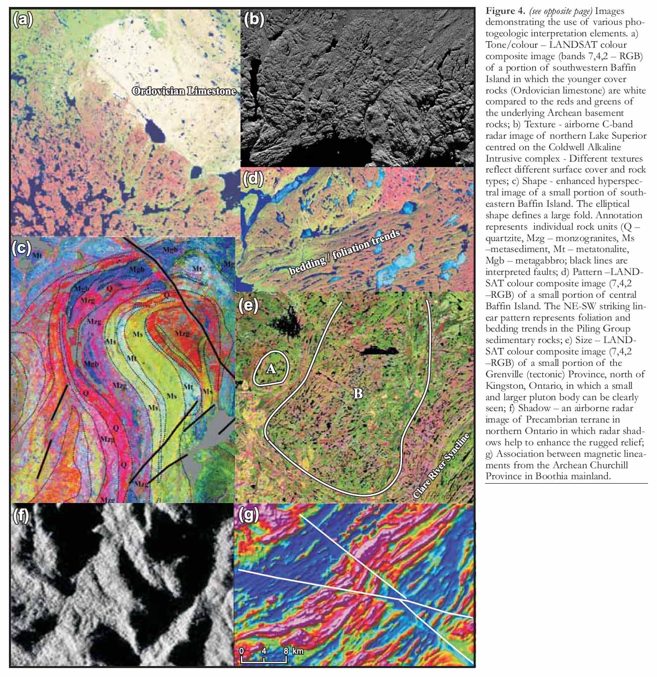
- Predicting the distribution of bedrock outcrop and other physio-graphic features, such as wetlands, forest fire burns, vegetation cover and infrastructure.
6 Thus predictive maps can present the geologist with a different paradigm for planning field traverses. Instead of regularly spaced traverse lines, more detailed traverses can be set up that are focused on more complex areas and on areas where bedrock out-crop has been identified. This is especially advantageous in Northern mapping campaigns where the territory is vast and mapping is expensive.
7 The mechanics of producing interpretations from various geoscience datasets are greatly facilitated by GIS technology. For example, image interpretations are accomplished directly on a computer screen as opposed to interpreting on mylar overlays. The advantage of this screen digitization process is that various enhanced images can be displayed quickly to facilitate interpretation by virtually real-time comparison between different data types at any scale. Much iteration is undertaken and each digital interpretation can be stored as a separate GIS layer. This bypasses the cumbersome procedure of scanning and digitizing hard-copy interpretations followed by georeferencing, which can introduce spatial errors. Similar to field mapping, the successful recognition and extraction of geological information is a learning process based on experience in interpreting image data in a variety of physiographic and geologic settings.
A SEVEN-SSTEP METHOD FOR RPM
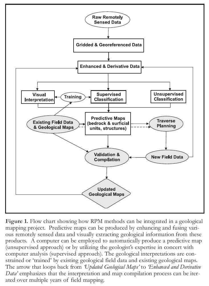
8 Remote Predictive Mapping proceeds by the acquisition, processing and geological interpretation of the available remotely sensed datasets; this results in predictive maps that outline the interpreted units and structures in the survey area. Remote Predictive Mapping either can be completed in isolation from field-based mapping or can be intimately integrated with it to ground-truth the interpretation as field mapping proceeds. Figure 1 shows a summary of the RPM process integrated into the work flow of a geological mapping project. The shaded portion represents the activities common to the "traditional" geological mapping process whereas the non-shaded portion represents the additional activities of the RPM approach. Regardless of whether the interpretation of remotely sensed data is fully integrated into a geological mapping project or not, the following seven-step program provides a systematic outline of a RPM work flow.
Figure 1. Flow chart showing how RPM methods can be integrated in a geological mapping project. Predictive maps can be produced by enhancing and fusing various remotely sensed data and visually extracting geological information from these products. A computer can be employed to automatically produce a predictive map (unsupervised approach) or by utilizing the geologist’s expertise in concert with computer analysis (supervised approach). The geological interpretations are constrained or ‘trained’ by existing geological field data and existing geological maps. The arrow that loops back from ‘Updated Geological Maps’ to ‘Enhanced and Derivative Data’ emphasizes that the interpretation and map compilation process can be iterated over multiple years of field mapping.
Display large image of Figure 1
1 Define Mapping Focus and Environment
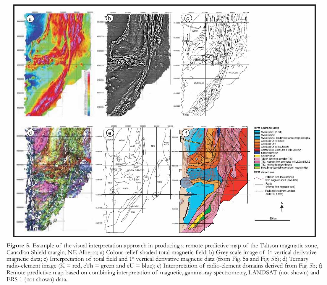
9 The first step in a RPM mapping project is to define the mapping context that include the following:
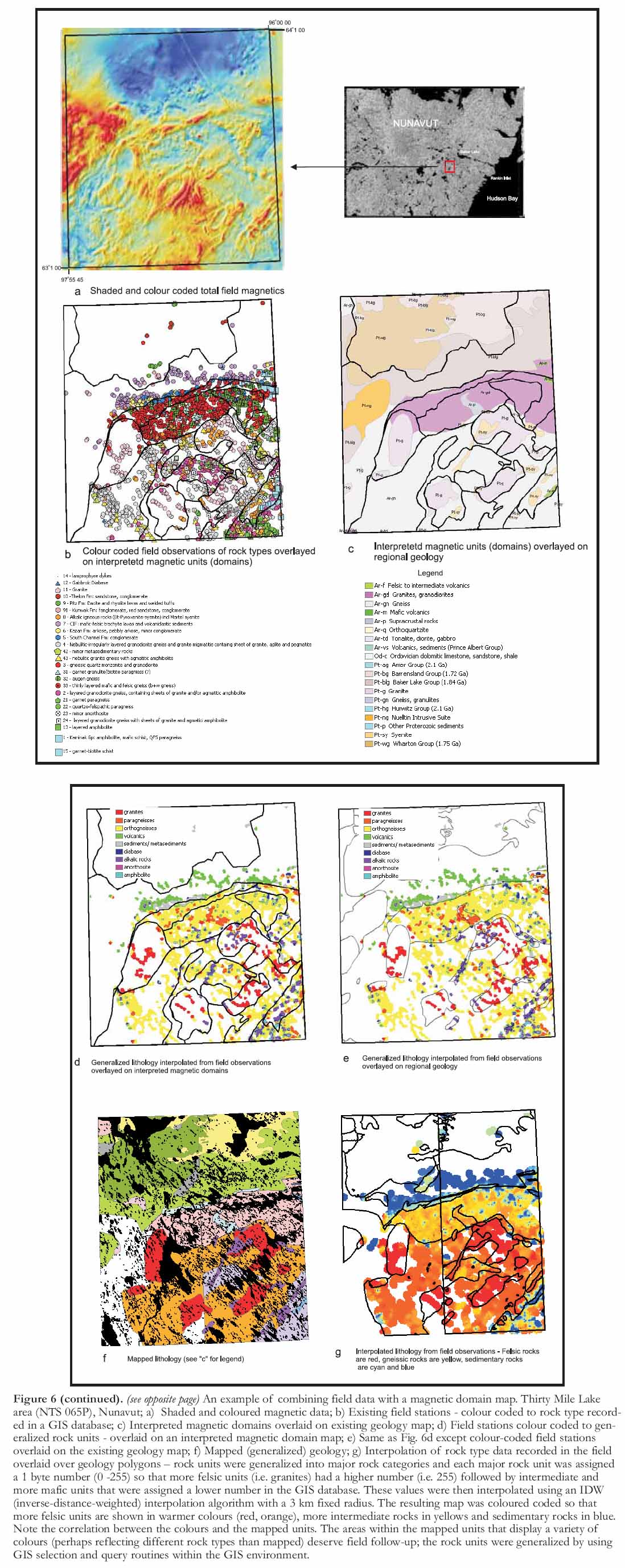
- Mapping focus: bedrock, surficial
- Nature of geologic terrane: sedimentary, igneous, metamorphic, tectonic setting
- Surficial conditions: degree of exposure, physiography
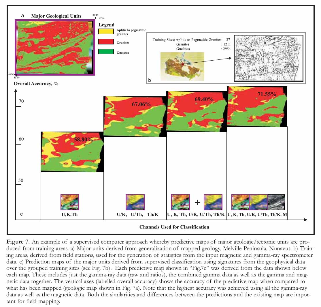
- Data availability: quantity and quality
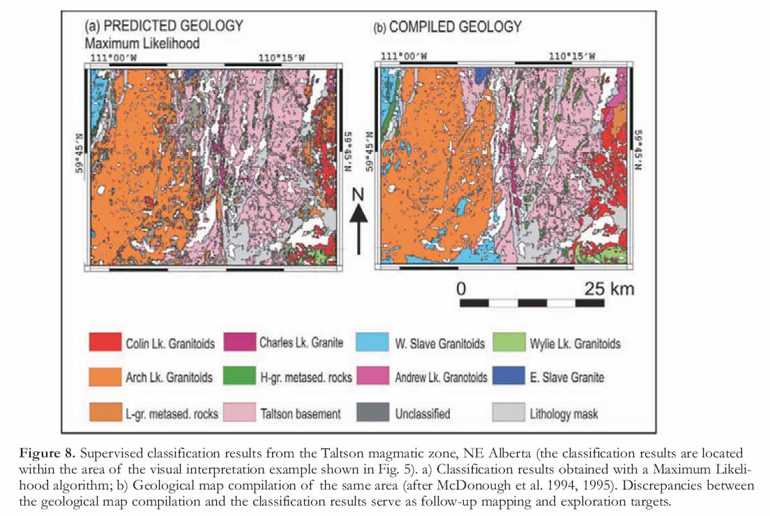
10 The specific mapping project will determine the data that will be most useful for mapping purposes. For example, in well-exposed terrains, bedrock-mapping projects that have a thin residual till cover will benefit from the interpretation of magnetic, gamma-ray spectrometry, optical and radar-image data. In areas where sparse out-crops alternate with thick overburden, bedrock mapping will primarily benefit from the interpretation of magnetic data.
11 In surficial mapping, optical and radar remote-sensing techniques, together with gamma-ray spectrometry and digital terrain data, will contribute to distinguishing the various types of surficial materials, identifying and mapping geomorphic features and mapping stream-lined glacial landforms that provide information on glacial movement.
12 When choosing datasets for geological interpretation, geological setting and terrain physiography, in combination with the spatial and spectral resolution, penetration depth, season of image acquisition and aerial coverage of the remote sensing system (including airborne geophysics) are all important factors that need to be considered.
2 Data Acquisition
13 Much of the geoscience data provided by governments and private-sector contractors/vendors are now in digital format and can be increasingly accessed through the internet. The core data types and datasets acquired and interpreted for a RPM project are listed in Table 1 with references to a sample list of websites. Most of these datasets cover the complete Canadian landmass (Fig. 2a) with the exception of gamma-ray spectrometry data (Fig. 2b). Non-proprietary, medium- to low-resolution geophysical data including magnetic and gamma-ray data can be obtained from the Geological Survey of Canada’s Geophysical data centre. LANDSAT 7 Enhanced Thematic Mapper 180 x 180 km scenes consisting of one 60-m resolution thermal band, six 30 m multispectral bands in the visible to mid-infrared range and one 15-m panchromatic band in the visible range may be obtained, free, from the Geogratis website [http://geogratis.gc.ca/]. RADARSAT data can be obtained from the Canadian Space Agency (CSA) for government users, and MDA Geospatial Services (formerly Radarsat International) for non-government users. Digital elevation data (DEM) (CDED at 1:50,000 and /or 1:250,000 scale) can be downloaded from [http://www.geobase.ca/]. The internet providers of optical remotely sensed data often include a quick look download service which allows inspecting cloud cover of the scenes before download.
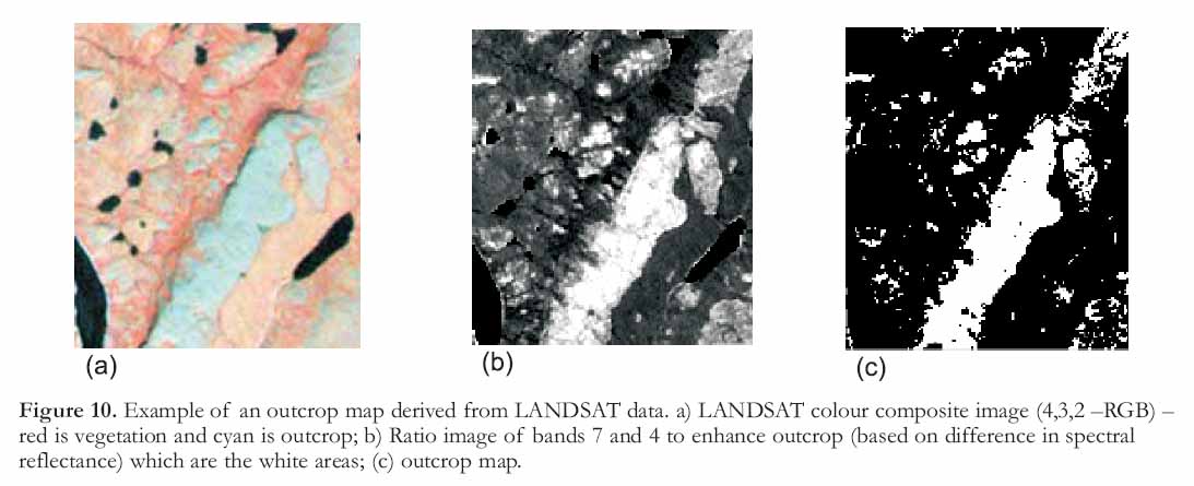
14 There are also a number of other specialized remote-sensing systems included in Table 1 that do not yet provide complete coverage of the Canadian land mass. Optical sensors including ASTER, SPOT, IKONOS, QUICKBIRD and airborne hyperspectral sensors can provide a wealth of geological information but these data are not available for all of Canada. However, if available, their use should be considered because they offer imagery at either higher spectral resolution (ASTER, 14 spectral bands) or higher spatial resolution (SPOT 5, IKONOS, QUICKBIRD). The higher spatial resolution of the latter sensor systems with 4.0 to 2.4 m multispectral and 1.0 to 0.40 m panchromatic data acquisition is not only useful for mapping and logistical planning but also as a navigational guide in hand-held field computers.
Table 1. Datasets used for RPM
Display large image of Table 1
15 Existing field and laboratory data and published geological maps can be integrated into the RPM process to guide, calibrate and test interpretations. This is accomplished by overlaying the field observations (lithologic unit, strike and dip measurements) on enhanced image layers in a GIS environment to assist in geologically calibrating the image interpretation of units or structures. Field data can also be used in training computer classification algorithms. The statistical relationships between the numerical values of image data (representing spectral reflectance, magnetic-field intensity, radar backscatter, etc) and lithological units can be computed at field stations and then used to predict other areas that have similar signatures.
16 Geological mapping is increasingly being supported by digital field data capture technology using hand-held computers and GPS. This is a revolutionary development with respect to RPM because it allows validating remote predictive maps on the out-crop. Simultaneous display of remote predictive maps and GPS position in real time, may lead the field geologist to make small deviations from planned traverses to inspect subtle anomalous patterns that appear to be geologically significant, when analyzed in context of the immediate surroundings of an outcrop. This may apply, for example, to confirming the presence of a dike, when short wavelength linear magnetic anomalies from near surface magnetic bodies appear to be in close proximity to the field site.
17 With respect to the interpretation of satellite image data (i.e. LAND-SAT, ASTER, SPOT, RADARSAT), sufficient time (commonly 6 to 12 months) should be set aside for the acquisition of new data before field mapping to allow processing and interpretation of the data. Also any new airborne geophysical surveys should be planned well in advance so that the data may be flown, processed and interpreted prior to field mapping. For optical and remotely sensed radar data, a narrow window lasting typically from mid-June to mid-September exists for acquiring new data in the North. Similarly, a narrow window also exists for the collection of airborne gamma-ray spectrometry data because any snow cover will absorb the gamma-ray emission. Airborne magnetic data, however, can be acquired through all the seasons. Provided that weather and terrain conditions are favourable, it is recommended that gamma-ray spectrometry data be collected in parallel with magnetic data as this will provide a geometrically consistent airborne survey consisting of magnetic, total-count, potassium, uranium, thorium and topo-graphic elevation channels providing complementary geological information at reduced survey costs.
Figure 2. Coverage maps of geophysical data provided by the Geological Survey of Canada. a) Coverage map of regional magnetic data; b) Regional gamma-ray spectrometer data. Higher resolution magnetic data may be obtained from provincial geologic surveys or through exploration companies.
Display large image of Figure 2
18 Dependent on the type of datasets acquired, various pre-processing steps may be required that have not been carried out by the data provider. In the analysis of optical remotely sensed data, for example, atmospheric corrections are necessary to compare multi- and hyperspectral remotely sensed signatures with field spectral measurements. This kind of pre-processing is not a trivial task and requires careful calibration routines to ensure the quality and integrity of the data is preserved. If this is not done properly then the analytical results obtained in a RPM project will be prone to error.
Table 2. RPM data types and products (maps)
3 Georegistration
19 The data acquired for RPM may have different georeferences (map datum and projection) although most spatial data warehouses in Canada now adhere to the NAD83 datum and UTM projection for the mapping scales typically employed in RPM (1 : 50 000 to 1 : 500 000 scales). Nevertheless, if legacy data in NAD27, province or larger scale map data with different map projections, GIS datum and projection transformations have to be employed to assure the appropriate georegistration of the RPM datasets. After the necessary datum and map projection transformations have been applied, it is good practice to make an assessment of misregistration between datasets by comparing the discrepancies between the landmarks (in Canada usually characteristic shapes along lake shores or river intersections) on various map and image layers due to non-systematic digitizing and/or registration errors.
4 Data Processing and Enhancement
20 A wide range of processing and enhancement methods can be used to facilitate extraction of geological information from RPM datasets (Table 2). Examples of enhanced image data (mainly from Canada’s North) are shown here (see Figs. 3 to 9). Generally, the methods employed depend on the data type to be enhanced. Derivatives of potential-field data include: vertical derivatives, upward continuation, analytic signal, magnetic susceptibility, and pseudogravity among others. Grids of measured magnetic and gravity data as well as their derivatives are enhanced by applying contrast enhancement and relief shading algorithms or both in combination (Milligan and Gunn 1997). Spatial convolution filters and colour enhancement techniques, such as decorrelation stretch (Gillespie et al. 1986) and saturation enhancement (Kruse and Raines, 1994) apply to enhancement of optical remotely sensed, multibeam radar and gamma-ray spectrometry data while band ratios or pairwise principal component analysis (Richards and Jia 2006; Jolliffe 2004; Jensen 1986) are useful to enhance geological information on multispectral or multibeam radar imagery. Most of these enhancements are generated semi-automatically using computer algorithms available with GIS and/or image-analysis systems. User input, however, is always important to fine tune the enhancement because this is guided by insight on how the dynamic range and spatial frequency distribution of the imaged physical properties are associated to geology.
Figure 3. Examples of integrated visualization of magnetic and gamma-ray data, Melville Peninsula, Nunavut. a) Gamma-ray spectrometry data combined (fused) with airborne magnetic data and topographic (elevation) data; b) 3-D visualization of coloured magnetic data draped over %K gamma-ray spectrometer data that supplies the "relief ", in this visualization higher relief represents higher K concentration in underlying rocks and surficial sediments; c) 3-D visualization of colour-coded equivalent uranium (eU) measured by an airborne gamma-ray spectrometer draped over an interpolated surface of ground-based measurement of eU that modulates the perceived "relief ". Correlation between airborne measurements in red indicating strong eU emission and high relief areas; also indicating strong eU emission can be seen clearly (Areas A and B).
Display large image of Figure 3
21 In addition to enhancement of individual data types, image fusion (Harris et al. 1999) combines image data into single images to highlight features of interest and analyze complementary geological information. Figure 3a shows an image fusion example in which gamma-ray spectrometry data have been combined with shaded-relief magnetic and topographic data. The gamma-ray data show three major geologic divisions: 1) the northwest portion of the area has variable radiometric signatures and magnetic response reflecting older pelitic and silicate gneisses interspersed with younger pegmatitic rocks, some of which have a distinct radiometric signatures (see Zone 1 on Fig. 3a), 2) a central zone, trending northeast, represents supracrustal and basement gneissic rocks (Penrhyn Group) of the Foxe Fold belt and, 3) a southern zone reflecting supracrustal marbles that are variably high in equivalent uranium (eU) and equivalent thorium (eTh). The linear magnetic anomaly patterns reflect tight upright folds comprising the fold belt. Rendering data as a 3-D surface is also instructive for studying the spatial relationships between different data types. For example, in Figure 3b total-field magnetic data is overlaid on a 3-D surface of the potassium (% K) gamma-ray spectrometry channel resembling a surface of topographic relief. This allows studying the spatial relationships between each dataset. Areas of anomalous response for both datasets can be seen at sites A and B (Fig. 3b) whereas areas of low response in the gamma ray and high magnetic response can be seen at site C. Figure 3c shows another 3-D surface visualization where the colour rendering is modulated by the Uranium (eU ppm) gamma-ray spectrometry channel and the "relief " is modulated by ground-based measurements of uranium. Areas of high uranium emission based on both the ground and airborne data are shown at locations A and B (Fig. 3b).
5 Data Analysis and Interpretation
22 Once derivatives and enhanced data are available for geological feature extraction, two basic approaches can be employed for producing remote predictive maps (see Fig. 2). These include visual interpretation of enhanced and fused imagery and computer-assisted interpretation methods. The subsequent sections discuss these methods and demonstrate how they can be employed in remote predictive mapping.
Visual Image Interpretation
23 Visual interpretation of the enhanced remotely sensed data can be based either on making hardcopy images or by digitizing on a computer screen. The latter method is more flexible as it allows for instantaneous display of different datasets, thus facilitating the extraction of complementary information while weighing the geological significance of image patterns in each of the data layers. It can provide interpretations of units, unit contacts or faults that are automatically georeferenced to the database, can be virtually overlain on other data for comparison, and can serve as a basis for geological map compilation once new field data are acquired.
24 Regardless of the data type being rendered, visual interpretation is based on recognizing geological features using seven diagnostic elements. These include: tone/colour, texture, shape, pattern, size, shadow and association (Drury 2001; Lillesand and Kieffer 2000). Examples of how each of the elements may contribute to recognizing geological features are shown in Figure 4.
Figure 4. Images demonstrating the use of various photogeologic interpretation elements. a) Tone/colour – LANDSAT colour composite image (bands 7,4,2 – RGB) of a portion of southwestern Baffin Island in which the younger cover rocks (Ordovician limestone) are white compared to the reds and greens of the underlying Archean basement rocks; b) Texture - airborne C-band radar image of northern Lake Superior centred on the Coldwell Alkaline Intrusive complex - Different textures reflect different surface cover and rock types; c) Shape - enhanced hyperspectral image of a small portion of southeastern Baffin Island. The elliptical shape defines a large fold. Annotation represents individual rock units (Q – quartzite, Mzg – monzogranites, Ms –metasediment, Mt – metatonalite, Mgb – metagabbro; black lines are interpreted faults; d) Pattern –LAND-SAT colour composite image (7,4,2 –RGB) of a small portion of central Baffin Island. The NE-SW striking linear pattern represents foliation and bedding trends in the Piling Group sedimentary rocks; e) Size – LAND-SAT colour composite image (7,4,2 –RGB) of a small portion of the Grenville (tectonic) Province, north of Kingston, Ontario, in which a small and larger pluton body can be clearly seen; f) Shadow – an airborne radar image of Precambrian terrane in northern Ontario in which radar shadows help to enhance the rugged relief; g) Association between magnetic lineaments from the Archean Churchill Province in Boothia mainland.
Display large image of Figure 4
25 Tone\Colour refers to the relative brightness or colour of objects in an image. It is the most fundamental element of image interpretation because its variation also allows appreciating other elements, such as texture, pattern and shape. Figure 4a shows how erosional remnants of a sedimentary cover consisting of Ordovician limestone can be differentiated from the underlying Archean granitoid basement by its relatively bright tone on a LANDSAT TM colour composite image of southwestern Baffin Island, Nunavut.
26 Texture refers to the magnitude and spatial frequency of tonal variations and can be qualified as smooth, moderately coarse or coarse. Figure 4b shows an airborne C-band radar image acquired over the north shore of Lake Superior, near Marathon, Ontario. Various image textures can be seen clearly ranging from smooth, fine and coarse to blocky (representing hilly terrain) that reflect different surface cover and rock types.
27 Shape refers to the general outline and form of individual objects in an image. This is one of the most diagnostic elements in visual interpretation. Figure 4c shows a hyperspectral image of a small portion (~ 5 by 5 km) of southeast Baffin Island showing a mushroom shaped, superposed fold pattern.
28 Pattern refers to the repetitive arrangement of discernable features in an image. Figure 4d shows a regular repetition of NE-trending linear features (structural form lines - bedding traces in Piling Group metasedimentary rocks) on a LANDSAT image of central Baffin Island.
29 Size refers to the dimensions of an object relative to other objects in an image, as well as its absolute size. A circular anomaly with a radius of 100 m or less could potentially be associated with a kimberlite pipe, whereas a circular magnetic anomaly with a radius of several kilometres is more likely a plutonic feature rather than a kimberlite pipe. An example of size (and shape) is shown in Figure 4e which is a colour LANDSAT image of the Grenville Province north of Kingston, Ontario. Two variable sized intrusive bodies can be clearly seen (Fig. 4e; A and B) around which are folded metasediments defining parts of the Clare River Syncline (Fig. 4e).
30 Shadow refers to the part of an object that is obstructed from incoming radiation from a natural, active or artificial energy source. Shadow provides a perception of the profile or relative height of a target. Shadow, however, may also hamper the identification of an object because it lowers, or completely obstructs, the reflectance from an object. An example of the application of shadow is shown in an airborne radar image of Precambrian shield terrane in Ontario (Fig. 4f). It is imaged at an incidence angle of 45° and the shadow areas (black) on the slopes facing away from the radar-look direction help to highlight the rugged topo-graphic relief of this locale.
Figure 5. Example of the visual interpretation approach in producing a remote predictive map of the Taltson magmatic zone, Canadian Shield margin, NE Alberta; a) Colour-relief shaded total-magnetic field; b) Grey scale image of 1st vertical derivative magnetic data; c) Interpretation of total field and 1st vertical derivative magnetic data (from Fig. 5a and Fig. 5b); d) Ternary radio-element image (K = red, eTh = green and eU = blue); e) Interpretation of radio-element domains derived from Fig. 5b; f) Remote predictive map based on combining interpretation of magnetic, gamma-ray spectrometry, LANDSAT (not shown) and ERS-1 (not shown) data.
Display large image of Figure 5
31 Association refers to the relationship of an object with other recognizable objects in the vicinity. The identification of features that one would expect to associate with other features may provide information to facilitate identification. Typical geological examples include radial drainage patterns around circular image objects, such as associated to impact structures, intrusive and tectonic domes and volcanoes. Figure 4g shows an example of an association between magnetic lineaments from the Archean Churchill Province in Boothia mainland. Two magnetic lineaments offset linear magnetic anomaly patterns associated with the foliation trends in Archean metagranitoids. The approximate 60° angle between the magnetic lineaments associated with the apparent dextral and sinistral offsets of the magnetic anomaly patterns, aids the inference that this pair of magnetic lineaments reflects a conjugate set of brittle shears.
32 Visual interpretation starts with selecting data that best reflects geology. This selection is guided by interactively overlaying digitized geological maps on various enhanced image datasets. Figure 5 shows an example of a visual interpretation effort for bedrock mapping from an enhanced and integrated remote-sensing dataset acquired over the Taltson magmatic zone exposed in NE Alberta (Schetselaar 2000). The interpretation of gridded magnetic data shown in Figure 5c was based on a colour-shaded relief image of the total-magnetic field (Fig. 5a) and a grey scale image of its 1st vertical derivative (Fig. 5b). A separate interpretation of radio-element domains (Fig. 5e) was based on a ternary radio-element image displaying K, eTh and eU in red, green and blue primaries respectively (Fig. 5d). A remote predictive map showing outlines of geological units and structures (Fig. 5f) was generated by reconciling conflicts between the interpretations of magnetic, gamma-ray spectrometry LANDSAT and ERS-1 data and integrating the information from the data layers with available geological maps. The gamma-ray spectrometry data were particularly useful for distinguishing various granitoid plutons and internal zoning within them, whereas the magnetic data permitted differentiation of the plutons from gneissic basement and enclaves of supracrustal rocks within the gneissic basement. The magnetic data, in addition to LAND-SAT and ERS-1 data (not shown) also allowed the outlining of dikes and other geological structures (e.g. regional foliation, folds, shear zones and faults).
33 If field data (observations from outcrops or rock samples) or existing geology maps are available they can be used to geologically calibrate image interpretations. Digitized geological themes (i.e. lithology, tectonic domains, structure, geochronology, mineralogy and alteration) may be overlaid on various enhanced images to establish the relationships between mapped geological features and image ‘signatures’. Corresponding patterns between both guide the geological interpretation in areas beyond the coverage of geological field data. Discrepancies between the geological map and image signatures within the coverage of existing data, alternatively, can provide rationale for reinterpreting map units and structures from geological field data. The interpretations can be over-laid on the existing geology map and adjustments can be made to reconcile differences between the two (Fig. 6c). Modified map(s) with some measure of geologic calibration (i.e. units are given a potential lithologic type) can then be produced (Fig. 6b). Figures 6d, e and g show different ways to assist in the calibration process, in which a geology map is used as a base, over which the various visualizations of field data are overlaid, such that areas of agreement and disagreement can be identified for follow-up field mapping.
Numerical Interpretation Methods
34 In addition, or as a complement to visual interpretation, numerical interpretation methods can be used to produce remote predictive maps (Fig. 1). Automated numerical methods can include supervised and unsupervised classification and image segmentation algorithms (Lillesand and Kieffer 2000; Richards and Jia 2006). These methods provide alternatives for extracting geological information in a systematic and unbiased manner, although visual interpretation is commonly judged to outperform methods of automated pattern recognition. However, numerical methods are superior to visual methods at simultaneously manipulating and interpreting multiple datasets having a large number of image variables.
35 The use of supervised classification methods allows geologists to have input into the map-making process by using geological field data during the training stage of the classification. In supervised classification, decision rules for class allocation are derived from multivariate statistics computed from the relationships between classes and image variables at the sample sites (i.e. field sites considered representative for bedrock or surficial units). The decision rules are used in the classification stage to allocate all pixels or grid cells to particular classes. The available classification algorithms differ in the way probability density functions for each class are modelled and estimated from the training data. The classification algorithms can be broadly categorized into: 1) parametric classifiers that model the class probability density functions with the estimated parameters of a multivariate normal distribution, or 2) nonparametric classifiers that directly estimate the class probability density functions from the data. A recommended practice is to experiment with a number of algorithms in an area where the geology is well known so that the performance of the different algorithms can be evaluated.
36 Figure 7 shows an example of supervised classification applied to gamma-ray spectrometry data over the Melville Peninsula, Nunavut. Training sites (Fig. 7b) for three major bedrock units (granites, gneisses and pegmatitic granites) have been selected from the geological map (Fig. 7a) and statistics from various combinations of the gamma and magnetic data have been computed and used to classify the data into the three major units using a maximum likelihood classification algorithm. Note the obvious similarity between the classified maps and the mapped geology. Classification accuracy (as measured against the "traditional" geology map) increases when both gamma ray and magnetic data are used. Classification accuracy range from 59% using eU, eTh and %K to 71% when the entire gamma (raw and ratios) and total-field magnetic data are used to produce the predictive map.
37 Another example of supervised classification applied to bedrock mapping is shown in Figure 8. Parametric methods (Maximum Likelihood and a Predictive Classifier) and a non-parametric method (Artificial Neural Network Classifier) were used to predict the ten lithological units in a training area in northeastern Alberta (Schetselaar et al. 2000). The training area is included in the area shown in the visual interpretation example of Figure 5. The resulting classification patterns yielded 65-70% correlation with the mapped geological units in the training area. The discrepancies between the classified patterns and the compiled geological map were used to identify targets for refinement of the geological map or as potential exploration targets. Some of the targets included internal zones in granitoid plutons, uranium anomalies, and magnetic intrusive units in the near subsurface. Similar to visual image interpretation, this study suggests that supervised classification is a useful method to assist geologists in fieldwork planning and in identifying targets for map refinement and exploration.
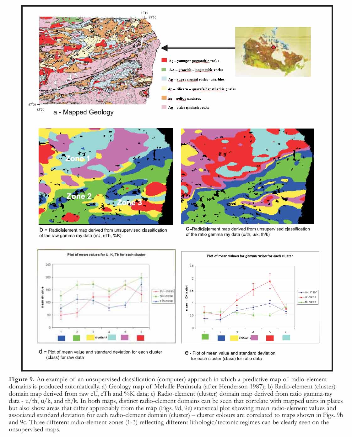
38 Contrary to supervised classification, unsupervised classification employs cluster algorithms to automatically produce a predictive map of image patterns with no direct input by the geologist (Harris 1989). This form of classification is most often used when no field observations or reliable geologic map data are available. The unsupervised approach may also be useful to extract unique anomalous patterns (interpreted as geological units or structures) from the image data that are not yet included in the existing geological knowledge base of the area. An example of unsupervised classification over the Melville Peninsula, in which a radio-element domain map is generated from the K, eTh and eU gamma-ray spectrometry channels and their ratios is shown in Figure 9. As previously discussed for the image fusion example shown in Figure 3a, the major division between the gneissic and younger granitic rocks in the north and northwest portion of the map (Zone 1) and the supracrustal and gneissic rocks of the Foxe fold belt in the south and southeast part of the map (Zones 2 and 3) are clearly demarcated. Generally, the radio-element responses are lower in the southeast (Zone 2) except over the supracrustal rocks dominated by marbles (Zone 3).
Figure 6. An example of combining field data with a magnetic domain map. Thirty Mile Lake area (NTS 065P), Nunavut; a) Shaded and coloured magnetic data; b) Existing field stations - colour coded to rock type recorded in a GIS database; c) Interpreted magnetic domains overlaid on existing geology map; d) Field stations colour coded to generalized rock units - overlaid on an interpreted magnetic domain map; e) Same as Fig. 6d except colour-coded field stations overlaid on the existing geology map; f) Mapped (generalized) geology; g) Interpolation of rock type data recorded in the field overlaid over geology polygons – rock units were generalized into major rock categories and each major rock unit was assigned a 1 byte number (0 -255) so that more felsic units (i.e. granites) had a higher number (i.e. 255) followed by intermediate and more mafic units that were assigned a lower number in the GIS database. These values were then interpolated using an IDW (inverse-distance-weighted) interpolation algorithm with a 3 km fixed radius. The resulting map was coloured coded so that more felsic units are shown in warmer colours (red, orange), more intermediate rocks in yellows and sedimentary rocks in blue. Note the correlation between the colours and the mapped units. The areas within the mapped units that display a variety of colours (perhaps reflecting different rock types than mapped) deserve field follow-up; the rock units were generalized by using GIS selection and query routines within the GIS environment.Figure 7. An example of a supervised computer approach whereby predictive maps of major geologic/tectonic units are produced from training areas. a) Major units derived from generalization of mapped geology, Melville Peninsula, Nunavut; b) Training areas, derived from field stations, used for the generation of statistics from the input magnetic and gamma-ray spectrometer data. c) Prediction maps of the major units derived from supervised classification using signatures from the geophysical data over the grouped training sites (see Fig. 7b). Each predictive map shown in "Fig.7c" was derived from the data shown below each map. These includes just the gamma-ray data (raw and ratios), the combined gamma data as well as the gamma and magnetic data together. The vertical axes (labelled overall accuracy) shows the accuracy of the predictive map when compared to what has been mapped (geologic map shown in Fig. 7a). Note that the highest accuracy was achieved using all the gamma-ray data as well as the magnetic data. Both the similarities and differences between the predictions and the existing map are important for field mapping.GIS Compilation of RPM Interpretation Results
39 The RPM process, as discussed in the preceding section, can result in one predictive map or a series of digital layers that can be "mixed and matched" within a GIS to create a number of predictive maps. Digitized geological themes (lithologic, tectonic domains, structure, geochronology, mineralogy and alteration – see Table 2) are overlaid on various enhanced images to establish the relationships between mapped geological features and image ‘signatures’. Furthermore, when digital interpretations are stored as GIS files, they automatically become part of the georeferenced database. This bypasses the need for manual digitization and georeferencing of hardcopy interpretations.
Figure 8. Supervised classification results from the Taltson magmatic zone, NE Alberta (the classification results are located within the area of the visual interpretation example shown in Fig. 5). a) Classification results obtained with a Maximum Likelihood algorithm; b) Geological map compilation of the same area (after McDonough et al. 1994, 1995). Discrepancies between the geological map compilation and the classification results serve as follow-up mapping and exploration targets.
Display large image of Figure 8
40 Typically, structural interpretations (bedrock and surficial) are first undertaken creating a series of "structural layers" (i.e. separate GIS files) that can also contribute to the final compiled map (e.g. form lines, folds, faults, contacts, domains, glacial-flow forms) or be saved as separate maps that form part of a portfolio for the study area. This is followed by interpretation of geologic divisions (e.g. rock units, tectonic domains, surficial materials) either by visual interpretation and/or by computer-assisted (i.e. classification) interpretation. For the spectral differentiation of units, it is often advantageous to restrict unit interpretations to areas of bedrock and residual weathered bedrock by masking vegetation, snow, ice and water. The masking is accomplished by defining thresholds in the pixel values of the ground cover classes using image threshold techniques.
41 The full GIS database including the interpretative layers can be taken into the field and maintained by a GIS specialist in the field camp. It is advantageous to have a GIS specialist in the field to maintain and update the RPM database on a daily basis and manage incoming field data collected on hand-held computers. In addition, the GIS specialist can maintain the hand-held computers, provide cartographic and plotting capabilities, assist in the analysis and quality control of newly collected field data, help adapt the mapping strategy based on comparison of new data to the RPM predictions and begin digital compilation (with the mapping geologists) of the new geologic map(s) while in the field.
6 Field Logistics and Planning
42 Remote predictive maps offer field geologists an excellent opportunity to better plan ground-based traverses, saving time, money and resources (e.g. fuel) in the field. In addition, better integration of remotely sensed data into field programs, especially optical and radar imagery can provide a map of terrain units including outcrop and wetland areas (Fig. 10). The combined geological and terrain information provided by RPM, allows focusing field mapping, on 1) areas where surficial conditions (i.e. higher density of out-crop, non-wetlands, terrain accessibility etc) are more amenable for field work, or 2) areas where the geology, as determined from the predictive map, is more complex. Given this, field traverses would be located heterogeneously throughout one large mapping area over multiple years of fieldwork instead of preparing a layout of regularly distributed traverses per field season. This strategic approach may prove to be more efficient and less costly than the traditional approach, because it allows more effort to be expended on accessible areas with more variable or complex geology.
7 Validation of Remote Predictive Maps
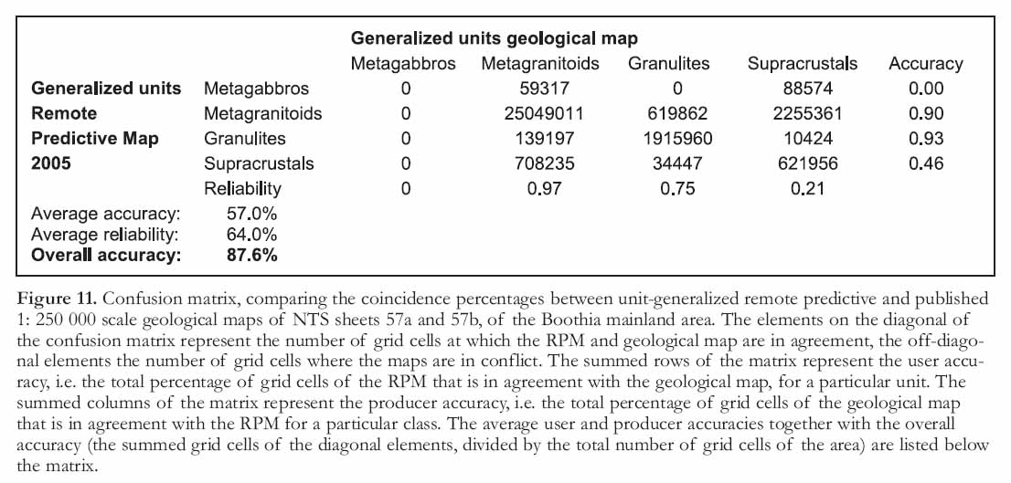
43 Like all predictions, remote predictive maps have an inherent degree of uncertainty (In fact all geological maps, no matter how they are produced have an inherent degree of uncertainty.). To assess the value and accuracy of a remote predictive map, it is important to understand map uncertainty and to have methods for assessing it. First, a qualitative assessment could be made by comparing the patterns of the remote predictive map with the patterns of the geological map compilation based on newly acquired field data. This should give some first order overall insight in the performance of the prediction. It should be noted, however, that discrepancies between mapped geology and the predictive maps are not necessarily interpretation errors, but could point to real geological features that are not or wrongly represented on the geological map. Such discrepancies could occur because units are generalized or poorly represented due to sparsely distributed field data or because there is no field control at all. One can also apply more systematic approaches by tallying the agreements and non-agreements between the units of the RPM and geological map at the visited field locations at various levels of map generalization. The results of this validation method can be represented in a confusion matrix (Fig. 11) in which the diagonal elements represent the number of field stations where RPM and geological maps are in agreement. In contrast, off-diagonal elements represent the number of field stations where RPM and geological maps are in conflict. The sum of the diagonal elements divided by the total number of field stations provides a measure of the overall accuracy of the prediction. In addition, the sums of rows and columns of the confusion matrix provide the "class accuracies" and "class reliabilities", respectively. This method of assessment assumes that the RPM and geological maps have the same unit legend. To generate a consistent legend, the RPM legend may have to be revised to a legend developed from data gathered in the field. Alternatively, the class names in both the RPM and geological maps could be strictly adhered to (and only field stations at which the RPM and geological maps have the exact same unit names will be considered correctly classified). This is likely to result in very low prediction accuracies that do not reflect the spatial agreement between the units of the RPM and geological maps. The discrepancies between the legends obtained from RPM and geological maps, as a result of the incongruence between field and image diagnostics, is an urgent issue on the RPM research agenda. Recent work in geography suggests that quantitative measures of semantic class similarity are feasible (e.g. Ahlqvist and Gahegan 2005). Such measures may be used to improve on the accuracy assessment methods for RPM as well.
Figure 9. An example of an unsupervised classification (computer) approach in which a predictive map of radio-element domains is produced automatically. a) Geology map of Melville Peninsula (after Henderson 1987); b) Radio-element (cluster) domain map derived from raw eU, eTh and %K data; c) Radio-element (cluster) domain map derived from ratio gamma-ray data - u/th, u/k, and th/k. In both maps, distinct radio-element domains can be seen that correlate with mapped units in places but also show areas that differ appreciably from the map (Figs. 9d, 9e) statistical plot showing mean radio-element values and associated standard deviation for each radio-element domain (cluster) – cluster colours are correlated to maps shown in Figs. 9b and 9c. Three different radio-element zones (1-3) reflecting different lithologic/tectonic regimes can be clearly seen on the unsupervised maps.
Display large image of Figure 9
OPTIMIZING ORGANIZATIONS TO SUPPORT RPM
44 Full integration of RPM into a mapping project can present organizations with operational opportunities and challenges. It is critical that RPM human-resource requirements and fundamental changes in work patterns are addressed (Franklin 2001; Schilling 2007). Remote predictive maps presents us with a heuristic change in how the mapping problem is approached and can have impact on the organizational aspects of how mapping is conducted. Remote Predictive Mapping may be implemented by a single individual with straightforward short term goals in mind that will have limited organizational impact. Alternatively, RPM activities may mandate large multi-disciplinary teams with a long term objective of mapping vast terrains. To increase the benefits in the later case, it is helpful to think through the administrative, technical and training support structures that are required. Staff may need to take time to acquire specific skill sets in predictive mapping, remote sensing, GIS or integration techniques.
45 For example, geologists may need to know how to do on-screen GIS interpretations, or a remote-sensing expert may need to upgrade basic knowledge of geologic principals. This could require a commitment of time and money for an organization. Consideration could also be given to the development of in-house training case studies, specifically tailored to the type of terrains an organization must deal with. For the "mapping process" to be successful, organizations and projects need to use scientists and technicians having broad backgrounds.
CONCLUDING REMARKS
46 Adoption of the RPM strategy necessitates a shift in a mapping paradigm that results in adjustments in the way the field mapping program is run, for traditional field geologists, remote sensing and GIS specialists and to a survey organization. However, in principal, it is not such a great leap for those who routinely interpret air photos (which still form an extremely valuable data source for RPM) in support of their mapping endeavours, to the interpretation of imagery acquired by Earth orbiting satellites or airborne systems. Remote Predicitive Mapping can be applied at various levels of sophistication with respect to digital processing and numerical interpretation methods. The visual interpretation of one to a few image and map layers can be as effective as computer-assisted pattern recognition from many image variables.
47 Success of an RPM strategy requires adoption of a multi-disciplinary team approach including geo-physicists, remote sensing, GIS experts and field mappers. This approach fosters team work both in the office and in the field. Furthermore, the RPM strategy allows for the production of not only 1 final predictive map but a number of intermediary map products (see Table 2) that may be useful for further mapping and exploration activities in the same area in future generations. Instead of publishing a "hardcopy" map exclusively, a series of images interpretations, field observations and notes, meta-data records and predictive maps can be published on a CD or DVD or through the web in a GIS-friendly format providing a permanent archive of all the geoscience data types for use by geologist and explorationists. This would ultimately allow for different or alternative interpretations to be made by others.
48 The RPM method is not static but is constantly evolving with respect to new sensor systems, methods to process and integrate data and innovations in geospatial data infrastructures to implement RPM. In the future, high-resolution remotely sensed data (i.e. SPOT 5) may replace air photos. Data from high-resolution sensors that cover wider areas, are easier to georeference (i.e. georeferenced data can be ordered directly from the vendor) and thus more easily incorporated into a digital GIS database than air photos, and provide a base for interpretation, plotting and in-field navigation using hand-held computers. In many instances, their geographic accuracy is better than the existing topographic maps of the North. Furthermore, high-resolution imagery can be collected for stereo viewing (i.e. overlapping acquisition swaths) facilitating geologic interpretation.
49 The following suggestions for future RPM mapping programs are based on our experience, to date, with mapping campaigns that have utilized RPM methods:
- Satellite and geophysical imagery (both magnetic and gamma-ray spectrometery) should be acquired early in the mapping project. This allows for ample time for pre-field analysis and interpretation. If mapping is planned in a northern location on the summer of 2008 for example, the satellite and geophysical data should have been collected in the summer of 2007 to allow for database building and RPM interpretation.
- High-resolution satellite imagery (i.e. SPOT 5, IKONOS, QUICKBIRD etc) are extremely useful for basic interpretation, as a navigational layer in field-data capture systems and as a plotting base for compilation work. The issue is cost and image size; however both of these will likely become less significant in the future as technology improves and costs are reduced.
- If legacy data are available, a point dataset of field sites and associated observations should be compiled in a GIS layer to support integrated geological image interpretation. This guides the digital compilation of units and structures and substantiates their allocation to field-established classifications.
- Groundtruthing during fieldwork is facilitated by uploading RPM interpretations on hand-held computers. This enables geologists to verify the existence of predicted geological features while traversing in the field.
- Screen digitizing of georeferenced geophysical and remotely sensed imagery is recommended to exploit the complementary information content of multivariate image data during image interpretation and avoid the time consuming and error-prone process of capturing interpretations made on hard copy maps and mylar overlays.
- RPM products can be used to assist in producing a topographic base for navigation and predict areas of bedrock exposure in support of traverse planning.
- RPM interpretations should ideally be performed by mapping geologists (with help of GIS or remote-sensing specialists). This allows geologists to play an integral role in the RPM process, gain insight in the relationships between field and image data and understand how the various imagery and enhancement techniques in concert with field data and maps contribute to the extraction of geological information.
50 Remote Predictive Mapping should lead to faster and less costly mapping cycles and production of a database of primary and interpreted datasets that enhances the re-usability of geoscience information in mapping and exploration. The success of RPM will largely depend on the GIS and remote sensing literacy of the future Earth scientists and on a deep understanding of the relationships between remotely-sensed physical properties and field/laboratory observations. The onus is on those for whom bridging the gap between the outcrop and multivariate birds-eye image perspective has become second nature. Only then can the complementary value of the exhaustive geological information, derived from sparsely distributed field sites and the indefinite, but spatially extensive geological information obtained by remote sensing, be synergistically exploited for geological exploration of the vast Canadian landmass.
ACKNOWLEDGEMENTS
The authors would like to thank Eric Grunsky from the Geological Survey of Canada, Don James from the Canada-Nunavut Geoscience Office and an anonymous reviewer for thoughtful comments and suggestions that have lead to a clearer presentation of this paper. This work was carried out and funded under the Remote Predictive Mapping Project, part of NRCAN’s Earth Sciences Sector’s (ESS) Northern Minerals Development Program. This paper is GSC contribution # 20070580.REFERENCES
Ahlqvist, O., and Gahegan, M., 2005, Probing the relationship between classification error and class similarity: Photogrammetric Engineering and Remote Sensing, v. 71, no. 12, p. 1365-1373.
Drury, S.A., 2001, Image Interpretation in Geology, 3rd edition: Cheltenham, UK. Nelson Thornes. Malden, MA. Blackwell Science, 304 p.
Franklin, U., 2001, The Real World of Technology: Canada, Anansi Press, 209 p.
Gillespie, A. R., Kahle, A. B., and Walker, R.E., 1986, Colour enhancement of highly correlated images. I. Decorrelation and HSI contrast stretches: Remote Sensing of the Environment, v. 20, p. 209-235
Harris, J.R., Viljoen, D., and Rencz, A., 1999, Integration and Visualization of Geoscience Data, in Rencz, A., ed., Remote Sensing for the Earth Sciences, Chapter 6, Manual of Remote Sensing, 3rd edition, v. 3: John Wiley and Sons Inc, New York, p. 307-354
Harris, J.R., 1989, Clustering of Gamma Ray Spectrometer Data Using a Computer Image Analysis System, in Agterberg F.P. and Bonham-Carter, G.F. eds., Statistical Applications in the Earth Sciences; Geological Survey of Canada, Paper 89-9, p. 19-32
Henderson, J.A., 1987, Geology of southeastern Melville Peninsula, District of Franklin, Northwest Territories, Geological Survey of Canada Map 1655A, 1:100,000 scale
Jolliffe, I. T., 2004, Principal Component Analysis, 2nd edition: Springer series in Statistics, New York, 486 p.
Kruse, F., and Raines, G., 1994, A technique for enhancing digital color images by contrast stretching in Mun-sell color space, in Proceedings of the ERIM Third Thematic Conference, Environmental Research Institute of Michigan, Ann Arbor, MI, p. 755 -760
Lillesand, T. M. and Kieffer R.W., 2000, Remote Sensing and Image Interpretation, 4th edition; John Wiley and Sons Inc., New York, 724 p.
Milligan, P.R. and Gunn, P.J., 1997, Enhancement and presentation of airborne geophysical data: AGSO Journal of Australian Geology & Geophysics, v. 17, No. 2, p. 63-75.
Richards, J.A. and Jia, X., 2006, Remote Sensing Digital Image Analysis: An Introduction, 4th edition: Springer, New York, 439 p.
Schetselaar, E.M., 2000, Integrated analyses of granite - gneiss terrain from field and multisource remotely sensed data: a case study from the Canadian Shield. Enschede, ITC, 2000. ITC Dissertation 73, 269 p. ISBN: 90-6164-180-2.
Schetselaar, E.M., Chung C.F. and Kim K., 2000, Classification of bedrock units in vegetated granite-gneiss terrain by the integration of airborne geophysical images and primary field data: Remote Sensing of Environment, v. 71, 89-105 p.
Schilling, M., 2007, Strategic Management of Technological Innovation: Singapore, McGraw-Hill Education, 312 p.
ENDNOTES
