ACID-3 Workshop, October 16-17, 2006
ACID WorkgroupDepartment of Earth Sciences, 3006 LSC, Dalhousie University, Halifax, NS, B3H 3J5 Canada
john.gosse@dal.ca
Submitted, 23 March 2007; accepted as revised, 20 April 2007
INTRODUCTION
1 The Atlantic Canada Ice Dynamics (ACID) workgroup comprises geoscientists in fields such as marine geophysics, sedimentology, oceanography, remote sensing, geomorphology, glacial geology, geochronology, glaciology and ice-sheet modelling, and paleoclimatology. The group meets biannually to discuss advances in knowledge of the dynamics in paleo-glacier ice cover throughout Atlantic Canada and related oceanographic, biologic, and climatic effects. For the past four years, the group has been charged with compiling and interpreting regional databases from geological surveys, producing glaciologically consistent conceptual models that are compatible with the history of eastern Canada ice dynamics. By using numerical simulations to evaluate the plausibility of these conceptual models, the group hopes to solve specific questions related to i) the nature and sources of late Pleistocene and Holocene meltwater pulses and marine sediments, and ii) the influence of polythermal ice-base conditions on till production and transportation. The two-day ACID-3 workshop was attended by 21 participants (Table 1) held at Dalhousie University, Halifax, Nova Scotia.
Table 1. Participants of ACID-3 Workshop
WORKSHOP OBJECTIVES
2 As in the past, the workshop used informal presentations, posters, mini-courses, and open debate and discussion to achieve its established goals. The ACID-3 workshop had three objectives: 1) to describe advances in Atlantic Canada Ice Dynamics research since the first ACID meeting (Gosse, 2002), 2) to consider the Nunatak Hypothesis and evidence for biological refugia, posited for disjunct flora and fauna throughout Atlantic Canada, and 3) to evaluate output from the latest version of the University of Maine Ice Sheet Model (UMISM) and test its plausibility against conceptual models of Atlantic Canada ice dynamics. Presenters included: i) S. Carr, genomics researcher from Memorial University, who provided a mini-course in the acquisition and phylogeographic interpretation of mitochondrial (mt)-DNA records from plants and animals, ii) D. Ruzzante, geneticist from Dalhousie University, who provided additional commentary, iii) J. Fastook, University of Maine, who provided an overview of the laws, rules, parameters, and other elements of the UMISM code and described the limitations and utilities of ice-sheet modelling, and iv) L. Tarasov, Memorial University, who provided additional commentary by comparing the results from the UMISM to his ice-sheet model.
PROGRESS IN ACID RESEARCH
Advances since ACID-1
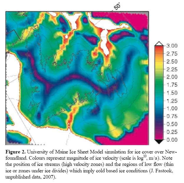
3 Significant developments in understanding the paleo-glacier ice dynamics of Atlantic Canada have been achieved over the past four years from the study of both land and marine records. Compilation of ice dynamics data from onshore and offshore records, including ice-flow directions, relative and absolute chronology, positions of marginal moraines, and other glacial land-forms that indicate streaming provide important insights into ice volumes and ice dynamics in Atlantic Canada. The value of data compilations is illustrated in the recent publication of a conceptual model of the deglacial history of southern Atlantic Canada (Shaw et al. 2006; Fig. 1), aspects of which have already been supported by simulations using a thermo-mechanical glaciological model (cf. Fig. 2).
4 Terrestrial cosmogenic nuclide (TCN) dating has enabled us to make profound advances regarding the nature and timing of deglaciation and the extent of ice cover in Atlantic Canada. Firmer constraints on the timing of deglaciation have been attained from TCN exposure dating of large (>2 m high) boulders from five regions that extend from southern Nova Scotia to the Cape Breton Highlands. The results support previous work by Stea and others, which showed that ice persisted through the Younger Dryas (YD) chron in the highlands of southern and central Nova Scotia. The data also refute the hypothesis of no ice cover (Nunatak Hypothesis) on the Cape Breton highlands. Spooner reported that in the Trout Pond Gulch region of western Newfoundland, cosmogenic 36Cl ages from boulders have documented an early deglaciation (by about 22 ka) followed by a transition to alpine glaciation and rock glacierization until about 12 ka (J. Osborn and others, unpublished data, 2007). Gosse reported 15 new TCN ages from boulders in Newfoundland, revealing that i) deglaciation along the south coast commenced after 14.0 ka, ii) that most highland areas in central, southern, and western Newfoundland were deglaciated within a 2 ka period following this, indicating a collapse of the Newfoundland ice sheet (with the exception of Big Level, a coastal highland in Gros Morne National Park which, in part, was deglaciated around 20 ka), and iii) that the Nunatak Hypothesis failed in all summit areas sampled (including two ‘type localities’ for the Nunatak Hypothesis—Big Level and St. John’s Highlands that were deglaciated 20.2±1.2 and 13.5±0.5 ka ago, respectively). Other TCN data from recently deglaciated areas showed that ice did not deeply erode the bedrock (1 m), which also supports the notion that cold-based, weakly erosive ice cover could preserve weathered bedrock.
5 Stea and Seaman both emphasized the need for research on pre-late Wisconsinan deposits that have been identified in Nova Scotia and New Brunswick (e.g. Godfrey-Smith et al. 2003). Knowing how these deposits correlate with the offshore stratigraphy may provide important constraints on Atlantic glacial conditions and isostasy leading into the last glaciation.
6 Important developments have arisen from offshore research. Brushett and Shaw reported on their groups’ progress in a large GSC program that, in part, will provide high resolution records from multi-beam bathymetry, seismic imaging, and coring to help provide land-sea correlations and interpretations of the ice dynamics in the Burin, Placentia Bay, and southwestern Avalon regions of Newfoundland and its adjacent shelf. Miller et al. and Piper et al. reported on developments in defining the position and timing of sedimentary fluxes onto the Atlantic shelf and slope, and their implications for paleoceanography in the north Atlantic during Holocene meltwater events related to a shrinking Lauren-tide Ice Sheet. For the first time, mapping of the nearshore coastal fringe— an area not included in either deep-water or land-based surveys—was described by Todd (starting with the Bay of Fundy). Webster described the application of new LiDAR instrumentation, now available at the Centre of Geographic Sciences in Nova Scotia, to nearshore coastal mapping (e.g. Webster et al. 2006).
Consideration of Biological Refugia and the Nunatak Hypothesis
7 For over a century a debate has persisted over the hypothesis that summits of coastal highlands exhibiting altitudinally separable zones of weathering were not ice covered in the last or penultimate glaciation. The difficulties in testing this hypothesis relate to i) accessibility of such areas in Baffin Island and northern Labrador, ii) the lack of glacial erosion or deposits in these areas, and iii) the lack of radiocarbon media that could be dated in areas that are above the treeline. In searching for an explanation for apparent disjunct distributions of some species (beetles, bryophytes, spiders) in Canada, Greenland, and Europe, many biologists proposed a model of ice free enclaves to provide refugia during glaciation.
8 The ACID-3 workgroup invited S. Carr to provide an overview of evidence for biological refugia from the organismal and mt-DNA perspective using records that have been attained throughout Atlantic Canada. Carr used the history of human expansion from Africa to exemplify the utility of the mt-DNA approach in dating the times of species expansion and diversification. He reviewed the latest mt-DNA data available for Newfoundland cod and caribou and concluded that the distributions are not consistent with any simple model of refugia or deglaciation. D. Ruzzante and others carried the discussion with examples from other species. Alternative explanations (i.e. in addition to the ice-free nunataks) for the phylogeographic relationships in Atlantic Canada include i) the species claimed to be disjunct from relatives in British Columbia or other continents may not be so related and require DNA analysis to demonstrate species-level relationships, ii) species found in coastal highland summits may live there because of narrow ecological tolerances, iii) alternatively, the refugia may be explained by a few local ice-free cliffs (between summit ice caps and valley glaciers) or by sea transgression-related isolation during deglaciation. More biological data are required before conclusions regarding the nature and timing of speciation in Atlantic Canada can be made, and the point was made that DNA-based phylogeographic analysis is significantly sensitive to the number of measurements made.
Figure 1. Conceptual model of the ice cover over Newfoundland during the last glacial maximum (modified from Shaw et al. 2006). Red dashed line indicates ice divide or ridge, thin blue lines represent generalized ice-flow trajectories.

Display large image of Figure 1
9 In 1993, TCN measurements provided insight into the glacial history of potential nunataks in Newfoundland (see Gosse et al. 2006, for a summary). Since then, more than 200 samples from summits have been measured for cosmogenic 10Be or 26Al/10Be ratios in Atlantic Canada and Baffin Island. Most of the summit and sub-summit erratics in northern Labrador span an age of 13-11 ka and are consistent with the YD chron (Marquette et al. 2004). In Labrador and Baffin Island, a similar situation to Newfoundland was unveiled by 26Al/10Be dating of bedrock surfaces (mostly on tor-like outcrops), which consistently reveal that the summit surfaces were buried (cosmic ray flux was interrupted) for durations of 105 to 106 years (Staiger et al. 2005, 2006). In north central Baffin Island, burial histories of at least 3 Ma are recorded by regolith and till, which only recently have been deglaciated (Staiger et al. 2006). The new TCN data and other geological evidence suggest that postulated nunatak summits, which are indeed more weathered, survived under ice that was mostly cold-based and non-erosive i.e. the summits were glaciated.
10 In summary, isotopic and geochronological data and land-based ice volume constraints refute the Nunatak Hypothesis (ice-free enclaves along coastal summit highlands). This applies to all localities known for weathering zones and biological refugia in western Newfoundland and northern Labrador, Nova Scotia, and New Brunswick. However, the possibility of cliff-based refugia has not been precluded.
Evaluate UMISM Simulations for Atlantic Canada
11 The last objective of the workshop was to evaluate high-resolution simulations from a thermo-mechanical ice-sheet model that was developed by J. Fas-took. The simulations were made available to the workgroup for evaluation in the form of downloadable movies. Fas-took reviewed details of the model design and reported results from three approaches for simulating ice cover in Atlantic Canada over the past 20 ka. In all three, Newfoundland retained an ice cap separate from the Laurentian Ice Sheet due to a significant draw down of ice via streaming and calving through the St. Lawrence – Laurentian Channel.
12 Several first-order features of the numerical simulations were supported by field evidence and the most recent conceptual model of deglaciation (Shaw et al. 2006). These features include i) the general position of ridges, divides, and domes in Newfoundland (compare Figs. 1 and 2) and New Brunswick, ii) the style of deglaciation of Newfoundland, with the Avalon Peninsula first, followed by a sudden collapse of central Newfoundland, iii) early deglaciation of summits, followed by delayed deglaciation in areas that had thicker ice, and (iv) cold-based ice in areas of thin ice or under ice divides, wet-based more erosive ice under areas of rapid flow or thicker ice. The model failed to produce a glacial history that even remotely resembles the conceptual model and field evidence for Nova Scotia, Prince Edward Island, and parts of New Brunswick (e.g. Stea and Mott 2005; Shaw 2006). Furthermore, the simulations predict that deglaciation occurred slightly earlier than suggested by available chronologies for the Atlantic region. Considering the close agreement with other aspects of Atlantic Canada deglaciation, the shortcomings were attributed to the lack of a reliable palaeoclimate signal for the past 100 ka (climate data on land exists only for post-glacial times, and offshore there are no continuous records of air temperature or precipitation). Tarasov described alternative approaches for modelling the glacial dynamics of the region, and the workgroup discussed some of the questions that can now be asked of the models, such as using the model output to fill gaps between well-dated relative sea-level records (e.g. Bell et al. 2003) or interpolation among ages defining a sea-level curve.
13 The existence of the proposed peripheral ice caps—independent from, but abutting against the Lauren-tide Ice Sheet—requires drawdown via an ice stream through the Gulf of St. Lawrence and Laurentian Channel with velocities of magnitudes similar to modern Antarctic ice streams. Evidence for these ice streams has already been identified throughout Atlantic Canada. The UMISM simulations predict ice domes, divides, and ridges in Newfoundland and parts of the Maritimes, which were conceptualized from the field data. However, ice-sheet simulations fail to support many observations from Nova Scotia and the Scotian Shelf, and yield deglacial chronologies and geometries of deglaciation that are inconsistent with the Nova Scotia geological record after 16 ka. A more robust regional climate model and more sophisticated calving and basal shear rules are required for simulations of second-order questions and any interpolations between field localities where geological observations are sparse.
FUTURE ACID RESEARCH AND WORKSHOPS
14 The workshop ended with a discussion of 15 key scientific questions that the group should address over the next two to four years. Considerable discussion regarded the evaluation of glacial erosion in a region covered by poly-thermal ice, and the subsequent sediment flux to the ocean (an extension of the international "source-to-sink" research but with an emphasis on the role of glacial dynamics).
Figure 2. University of Maine Ice Sheet Model simulation for ice cover over Newfoundland. Colours represent magnitude of ice velocity (scale is log10, m/a). Note the position of ice streams (high velocity zones) and the regions of low flow (thin ice or zones under ice divides) which imply cold based ice conditions (J. Fastook, unpublished data, 2007).
Display large image of Figure 2
15 The results will likely have an impact on geodynamical studies of active orogens that have been glaciated, and can provide insights into the magnitude and fluctuation of sediment loading on the continental margin (e.g. Skene and Piper 2006) and their effect on salt deformation in petroleum source basins.
ACKNOWLEDGEMENTS
The ACID Workgroup thanks the Atlantic Geoscience Society (AGS), Canadian Geomorphological Research Group (CGRG), and ACOA (Atlantic Innovation Fund #1001052) for support of the ACID-3 workshop.REFERENCES
Bell, T., Batterson, M.J., Liverman, D.G.E., and Shaw, J., 2003, A new late-glacial sea-level record for St. George’s Bay, Newfoundland: Canadian Journal of Earth Sciences, v. 40, p. 1053-1070.
Godfrey-Smith, D.I., Grist, A.M., and Stea, R.R., 2003, Dosimetric and radiocarbon chronology of a pre-Wisconsinan mastodon fossil locality at East Mil-ford, Nova Scotia, Canada: Quaternary Science Reviews, v. 22, p. 1353-1360.
Gosse, J., 2002, Atlantic Canada glacier ice dynamics workshop: Geoscience Canada, v. 29, p. 183-186.
Gosse, J.C., Bell, T., Gray, J., Klein, J., Yang, G., and Finkel, R., 2006, Using cosmogenic isotopes to interpret the landscape record of glaciation: Nunataks in Newfoundland: in, Knight, P., ed., Glaciers and Earth’s Changing Environment: Blackwell Publishers, p. 442-446.
Marquette, G. C., Gray, J. T., Gosse, J. C., Courchesne, F., Stockli, L., Macpherson, G., and Finkel, R., 2004, Felsenmeer persistence through glacial periods in the Torngat and Kaumajet Mountains, Quebec-Labrador, as determined by soil weathering and cosmogenic nuclide exposure dating: Canadian Journal of Earth Sciences, v. 41, p. 19-38.
Shaw, J., 2006, Palaeogeography of Atlantic Canadian continental shelves from the last glacial maximum to the present, with an emphasis on Flemish Cap. Journal of Northwest Atlantic Fishery Science, v. 37 (Flemish Cap Symposium, 2004). Online at: [http://journal.nafo.int/37/shaw/10-shaw.html]
Shaw, J., Piper, D.J.W., Fader, G., King, E.L., Todd, B.J., Bell, T., Batterson, M.J., and Liverman, D.G.E., 2006, A conceptual model of the deglaciation of Atlantic Canada: Quaternary Science Reviews, v. 25, nos. 17/18. p. 2059-2081.
Skene, K.I. and Piper, D.J.W., 2006, Late Cenozoic evolution of Laurentian Fan: development of a glacially-fed submarine fan: Marine Geology, v. 227, p. 67-92.
Staiger, J. W., Gosse, J. C., Johnson, J., Fastook, J., Gray, J. T., Stockli, D., Stockli, L., and Finkel, R., 2005, Quaternary relief generation by polythermal glacier ice: a field calibrated glacial erosion model: Earth Surface Processes and Landforms, v. 30, p. 1145-1159.
Staiger, J., Gosse, J., Little, E., Utting, D., Finkel, R., Johnson, J., and Fastook, J., 2006, Glacial erosion and sediment dispersion from detrital cosmogenic nuclide analyses of till: Quaternary Geochronology, v. 1, no. 1, p. 29-42.
Stea, R.R., and Mott, R.J., 2005, Younger Dryas glacial advance in the southern Gulf of Lawrence, Canada; analogue for ice inception?: Boreas, v. 34, p. 345-362.
Webster, T.J., Murphy, B., Gosse, J., and Spooner, I., 2006, Coupling LiDAR-derived landscape metrics and surface processes: An example from the Fundy Basin, Nova Scotia, Canada: Canadian Journal of Remote Sensing, v. 32, p. 173-193.