Articles
Wəlastəkwey (Maliseet) Homeland:
Waterscapes and Continuity within the Lower St. John River Valley, 1784-1900
After decades of intense immigration to the lower St. John River Valley, the Maliseets, the Indigenous people of this watershed, struggled to inhabit the southern portion of their homeland. The Maliseets, though, successfully retained their cultural attachment to the lower river, the lakes, and the coast through birchbark technology and fishing. Their historical memory also provided alternative narratives to dispossession and conveyed a waterscape where Indigenous lifestyles coexisted with societies in New Brunswick. And while some Maliseet families chose to live beyond their reserve villages, Indigenous leaders secured two small reserves at The Brothers (Kennebecasis Bay) and Oromocto.
Après des décennies d’une intense immigration dans la vallée du Bas-Saint-Jean, les Malécites, le peuple autochtone de ce bassin versant, eurent des difficultés à habiter la partie sud de leur territoire. Les Malécites réussirent cependant à maintenir leur attachement culturel au cours inférieur du fleuve, aux lacs et à la côte grâce à la technologie de l’écorce de bouleau et par la pratique de la pêche. De plus, leur mémoire historique offrait d’autres récits que ceux de dépossession et évoquait un paysage aquatique où les modes de vie autochtones coexistaient avec les sociétés au Nouveau-Brunswick. Et les dirigeants autochtones obtinrent deux petites réserves à The Brothers (baie de Kennebecasis) et à Oromocto, même si certaines familles malécites choisirent de vivre à l’extérieur des villages de leur réserve.
1 IN THE LATE 19TH CENTURY, MALISEET ELDER GABRIEL ACQUIN (1811-1901) viewed Fredericton from across the St. John River at the St. Mary’s Reserve (Sitansisk). The skyline of the provincial capital possibly served as a vivid reminder of the changes that occurred over his lifetime. The first bridge at Fredericton, built in 1885, assisted residents crossing the river, but this imposing structure undervalued the importance of his knowledge about the river that he acquired from personal experiences on the water. Acquin’s rich life in the river valley taught him that there were variations of the intensity of Euro-Canadian presence in his homeland, and that paddling his birchbark canoe upriver or into an adjacent tributary reminded him that he could temporarily escape from the enclaves of towns or farms to hunt or fish.1 Acquin knew that most of his people lived upriver on reserves, but frequently returned downriver to retain cultural connections to their ancestral homeland in the lower river valley. While government authorities used survey maps, prior proclamations, land seizures, and maybe even works of art in the process of supplanting Aboriginal lands and resources, there were some components of his people’s homeland that remained the same.2 The St. John River at St. Mary’s, altered by industry for over a century, still flowed south. The confiscation of Maliseet lands and waters was neither a linear process nor limited to a few decades, but it ebbed and flowed with the changing times. Despite the power of colonialism during the 19th century, dispossession was not an absolute result but a process in which the Maliseet learned ways to maintain a presence even in the southern portion of their homeland.
2 Understanding the mechanisms of the provincial government is an important component to decolonization methodologies, but equally imperative is understanding the Indigenous decisions and the ways in which people maneuvered within or outside colonialism in attempts to achieve their objectives.3 Dispossession did not result in a complete severance of Maliseet seasonal mobility and the fishing activities that accompanied this movement, but it did change the terms by which Aboriginal families lived in the lower river valley. Similar to their Mi’kmaw neighbors, Maliseet experiences extended beyond the grasp of colonialism.4 Undoubtedly immigrants drastically changed the land and water in the St. John River Valley, but the Maliseets still maintained a sense of “homeland” – a contemporary term that emphasizes a strong attachment to a region that had fallen out of Aboriginal ownership.5 Family ties to the land and water were a central component of Maliseet identity and their waterscape knowledge ran deeper than any river, preceding European arrival by thousands of years.
3 Scholarship on “spaces of power” initially focused on Indigenous trade alliances and diplomacy, noting that terrestrial space, including riverine transportation, remained in Indigenous control.6 Other works emphasize that European arrival changed Aboriginal societies forever, as these communities made decisions to best confront these changes.7 In the Maritime colonies, specifically in Nova Scotia, “shared” or negotiated spaces represent Mi’kmaw and British experiences during the mid-18th century.8 According to Thomas Peace, social geographer Henri Lefebvre understood the production of space as involving “perceptions, conceptions, and lived experience.”9 The Maliseets and their non-Aboriginal neighbors, not surprisingly, understood the land and water quite differently; although the latter may have achieved “settler sovereignty” by the mid-19th century, Aboriginal people still preserved, recovered, and restored their own spaces.10
4 Recently historians have shown that bodies of water are essential to many Aboriginal peoples and that the juxtaposition of water to land reveals new understandings about contested spaces or power structures in the past.11 As waterways vary considerably from region to region, “waterscapes” is used here to convey not only a diverse and unique river system that changes with the seasons but also with daily transformations caused by tidal currents or wind shifts that can dramatically alter the surface of the water. The term also encompasses human actions, including the construction of dams on its tributaries that resulted in different aquatic habitats and that shaped perceptions of the river. Waterscapes embrace a variety of bodies of water in the valley, from large lakes connected by thoroughfares to small streams and wetlands that flow into the main branch of the St. John River. Self-identified as Wəlastəkwewiyik, meaning “people of the beautiful river,” the Maliseet people derived their name from the river that they call Wəlastəkw.12 Similar to the transitory nature of water itself, Maliseet waterscapes also comprised the river mouth and the rocky coastline around St. John Harbour in the Bay of Fundy. The term “waterscapes” highlights the importance of water in Maliseet culture and acknowledges the expertise required to traverse it. Indeed, water was the key component of their ancestral homeland.
5 Building upon Thomas Peace’s work on the production of space involving “perceptions, conceptions, and lived experience,” three different approaches – waterscapes, memory, and connections to the Maliseet homeland in the lower St. John Valley – can provide a more complete view of Maliseet experiences during the 19th century. First, the Maliseets preserved their connections to the lower river and the Bay of Fundy through their extensive knowledge and daily use of the different waterscapes in the region. Birchbark canoe technology and the Maliseets’ in-depth experiences on the water made them unsurpassed in their skills and knowledge required to traverse their homeland. Maliseet “spaces of power” may have been curtailed by the physical presence and number of non-Aboriginal people, but it remained to a degree on the water.13 Dispossession and the construction of impoundments changed the river and limited fish habitats, but some fisheries remained important. Second, historical memories on the water – showing continued use of waterscapes and its impartiality to human use – offer an alternative narrative to dispossession. Seasonal change or even the daily setting of the sun could return some water places back to Maliseet use, especially through night fishing and canoeing. And lastly, Indigenous families chose to live beyond their reserve boundaries and the changing spatial distribution reveals that they experienced a wide variety of interactions with non-Indigenous people. Maliseet leaders adopted techniques, including the right to petition and the construction of physical buildings, to secure two reserves at The Brothers and Oromocto (Welmooktuk). 14 The Maliseets who received a license of occupation, which is not a land grant, struggled to keep their land.
6 Maliseet and non-Aboriginal conceptions of land differed greatly, with each group possessing their own spatial arrangements on the land and water. Aboriginal families canoed to old campsites that were seasonal settlements year after year. Camp life depended on the natural world in the immediate vicinity for obtaining food and firewood. Supplies were kept to a minimum as people moved in and out of New Brunswick colonial society. Upriver in reserve villages, people frequently arrived and departed, a degree of movement unlike in any colonial town.15 Seasonal use of specific areas led some government officials to falsely conclude that families had abandoned the area when, in actuality, they were on the move. Movement made sustaining their lands difficult as presence and land ownership were irrevocably linked in the eyes of the settler-colonial state. Colonial towns were fixed communities connected together by roads and bridges. A year-round residence exhausted the nearby natural resources needed for survival. The Maliseet intertwined cultural values of a place with economic opportunities, allowing some space for flexibility at a time when none, for settlers, seemed to exist.16 A birchbark wigwam, a conical dwelling that created their interior space, was not a place to discard, but instead was a preferred living arrangement. The circular interior, the smell of fresh cut fir boughs interlaid on the floor, and the sound of a crackling hearth were at the center of life that was well worth preserving within the context of widespread dispossession.17
7 The intense resettlement of the lower St. John River Valley by Loyalists and later immigrants led the Maliseets to adopt new ways of retaining their presence in the lower part of this river system, especially their connection to the river. In contrast to the upper river valley from Fredericton to northwestern New Brunswick where the pace of Euro-American settlement was slow, the lower river valley had been an area where the Maliseets first confronted Europeans and felt the repercussions of the colonial wars.18 Throughout the 17th and most of the 18th centuries, the Maliseets retained much of their power in their homeland.19 After 1713 the British claimed the river valley; but it would take another half century before pre-Loyalist immigrants spread upriver at the close of the Seven Years’ War (1754-1763), causing tension between the Maliseets and British to escalate.20 Even before the American Revolution, the 3,000 to 4,000 pre-Loyalists and Acadians who primarily inhabited the lower St. John Valley outnumbered the Maliseets.21 The 1783 Treaty of Paris that formally ended the Revolutionary War (1775-1783) resulted in waves of Loyalist families arriving in Saint John Harbour to obtain land grants and to relocate upriver.22 News of peace in 1783 caused the Maliseets to encounter a massive influx of Loyalist immigration that advanced up the St. John River and threatened to further displace and dispossess them of their land. Nova Scotia and later New Brunswick colonial officials sought to “fill the map” with lots assigned to land owners, and assembled these land grants on maps that showed parcels assigned to the original grantees.23 The Maliseets experienced profound changes that would directly impact their lives and severely affect their homeland, a region that encircled the largest watershed in the Maritime Provinces.24
8 The Maliseet homeland at that time was not just the land but also the river itself; the lower St. John was a unique waterscape that the Maliseets knew well. It included the lake systems and stretched from Fredericton to Saint John on the Bay of Fundy, totalling about 125 kilometers.25 The St. John River begins at 480 meters above sea level along the present-day border of the State of Maine and the Province of Quebec and flows in a northeast direction, forming a large arc that gradually turns south. After 675 km, the river empties into the Bay of Fundy, draining an area of 55,000 km². One 19th-century traveller noted that the St. John River and its tributaries offered about 2,630 miles “fit for canoeing.” The river’s narrow mouth combined with the Bay of Fundy’s strong tides to create a brackish estuary deep into the interior of New Brunswick. The cliffs at the river mouth may have limited but not prevented Maliseet canoe access points to the bay. Along the lower St. John River, four large bodies of water, including the Grand Lake system, which is comprised of 22,000 hectares of open water, trap heat and create a warmer climate along the extensive floodplains.26 River water below the head of the tide at Ekwpahak, just north of Fredericton, can be brackish, making these large bodies of water vary from largely fresh water (or lakes) in the north to more saline areas (or bays) in the south. Below Grand Lake, listed from north to south, are Washademoak Lake, Belleisle Bay, and Kennebecasis Bay. Each of these four bodies of water formed a distinct open-water environment in the valley that the Maliseets frequented with their dip nets to fish.27 As the largest river in the Maritime Peninsula, the St. John River delivers about 32 cubic kilometers of fresh water per year into the Bay of Fundy, almost 33 percent of the total fresh water flow in the Gulf of Maine.28
9 The lower St. John River provided the Maliseets with an intricate waterway system used for the transportation of family groups, who often traveled to established camp sites and visited hunting or fishing grounds. Crucial to this water knowledge was the Indigenous technology of the birchbark canoe. The perfected design made with birchbark, cedar, and spruce root made this watercraft superior for river use. The small draw of the birchbark canoe enabled access to low-water streams where other types of boats, including the heavy bateau, dragged on the rocky streambed. The light weight of the canoe also made it easier to portage from one water system to the next. Indigenous youth acquired navigation skills needed to pole or paddle the canoe in a variety of different water settings, and learned to maneuver the craft to assist them in their hunting and fishing practices. In addition to their expertise with the birchbark canoe, the Maliseets mastered the physical waterscapes that entailed not only knowing the location of obstacles such as sharp rocks breaking the surface of the water or dangerous rips but also the geography of the waterscapes to help them determine the location of a specific lake or stream outlet or to ascertain the main branch of the river. Knowledge of the changing weather or tidal patterns assured safe passage that avoided dangerous waves that could capsize a canoe. The physical act of padding or poling to travel reinforced a respect for the water, and living on it shaped the Maliseet views of their homeland.29
10 During the 19th century, canoeing the Maliseet homeland required sharp observations and specific knowledge of the numerous tributaries flowing into the St. John River. Geological surveyor Abraham Gesner traveled with three Maliseet and Mi’kmaw men across the province, which showed him that their “acuteness” to the river valley was “almost supernatural.” Gesner noted: “His powers of observation are so perfect, that he can trace on a piece of bark, with a bit of charcoal, the geography of the country he has traversed; and he will take a direct course to a place hundreds of miles distant, without the aid of a compass.”30 Tributary outlets were sometimes concealed with a fallen tree or overgrown bushes that could easily obscure a portage path, but the Maliseets often marked trees and rocks with images to provide land and water information to community members for safe travel. Once Gesner learned about these Indigenous maps, he benefited from the information they provided. Near Eel River, he saw a carving on a cedar tree of a man carrying a birchbark canoe over his head, indicating to Gesner’s party that they had approached a portage path. In another instance, the party saw a map in black ink on a piece of cedar “secured to a post” that showed canoeists with their heels in the air and a capsized canoe, warning that dangerous falls lay ahead. An image of a hunter leveling his firearm at two deer revealed that there were plenty of game animals in the area. Indigenous maps, whether engraved in birchbark or scratched onto cedar with charcoal or ink, conveyed critical knowledge needed to safely traverse the Maliseet homeland.31
11 The sheer volume of the St. John River flowing through a narrow passage into the Bay of Fundy, combined with the strong and semidiurnal tides pushing against the current, creates the “Reversing Falls,” where the river empties into the Bay of Fundy. Birchbark canoes could only run the Reversing Falls in Saint John 4 times in a 24-hour period, probably for only 15 to 20 minute intervals.32 If the tide was not optimal for traversing the falls, a short portage in Saint John provided alternative access to the Bay of Fundy.33 Such a treacherous waterscape not only required skills and knowledge, but also a level of respect to traverse it. In St. John Harbour near the Reversing Falls, a boulder, which the Maliseets called “Gtchi-quaabeet-a-wi-cup-ahegan” – meaning “great beaver’s dam” – connected the distant past with the waterscape. Oral tradition recounted that the cultural hero Gluskap had broken up the giant beaver dam but, as one of the beavers tried to escape by swimming upriver, he threw two boulders as far as Tobique to crush the huge animal, which later died of exhaustion. The Maliseets in birchbark canoes, who decided to paddle through the falls, remembered the story of the giant beaver and offered tobacco at the rock in the falls to assure a safe voyage into the Bay of Fundy.34
12 The aquatic environment known for its rich fishery was an important component of the Maliseet homeland. After spending most of their lives in the ocean, anadromous fish, including Atlantic salmon, shad, and alewives, ascended the St. John River and its tributaries to spawn in the spring. As these species of fish became increasingly scarce during the 19th century, government officials implemented a series of conservation laws. Other migratory fish, including the Atlantic sturgeon and the American eel, may have been more important to the Maliseets.35 Some New Brunswickers considered sturgeon an undesirable table fish, possibly resulting in the species survival into the late 19th century.36 The numerous nets around Saint John Harbour and Maliseet harpoons were the primary threats to the sturgeon.37
13 In the St. John River, Atlantic sturgeon grew up to eight feet in length and their grayish-brown bodies with five rows of modified bony scales called scutes gave them a prehistoric appearance. As an anadromous fish, sturgeon spent most of their time in saltwater, but spawned in freshwater. In May, the fish ascended the river as far as Fredericton and selected sandy shoals, often at Oromocto and Grand Point on Grand Lake. On hot days, sturgeons often jump, hurling their entire body out of water. Some contemporary scientists believe that this behaviour is a form of social communication, but, in the 19th century, fishery commissioner Moses Perley held that jumping dislodged the lamprey eel that attached itself to the fish’s soft underbelly.38 As several Maliseet canoes were salmon spearing below the falls on the Nashwaak River, a sturgeon jumped next to Molly Greenbazie and landed in her canoe with such force that the fish broke through the canoe bottom. She quickly seized the tail of the large fish, thereby suspending the sturgeon half in and half out of the canoe. As the position of the fish’s body stopped the water from rushing in and sinking the canoe, Greenbazie quickly paddled safely to shore.39
14 While Greenbazie’s experience may represent an unusual example, fishing for Atlantic sturgeon was not an easy task as it required group cooperation with several canoes. Standing at the bow of a birchbark canoe with a harpoon in hand, one gave hand signs to the stern paddler to direct the canoe towards its prey. The iron harpoon had two barbs on the same side spaced two inches apart. Once the harpoon struck a sturgeon, the point separated from the wooden handle tethered together by a piece of moose hide. The sturgeon fought against the pull of the harpoon head lodged in its body, and dragged the canoe “in tow.” The force sometimes upset the canoe and the “scuffl[ing] and splashing” alerted the other canoes to come to their aid. To prevent the upset of the canoe from the sturgeon’s tremendous force, a log tethered to a harpoon line could, when thrown overboard, serve as a buoy until the fish tired. According to Maliseets, the sturgeon body had eight different kinds of meat, some of which was cubed up and salted “for winter use.”40 They dried sturgeon roe and after rolling each egg with their fingers to separate the yoke from its sack, the individual eggs were dried again in the sun and often smoked for subsequent storage in birchbark containers. The smoked roe was often added to cracked corn and boiled to make “Qunosk-ke-te-ga-ne Nsabon” or boiled corn pudding.41
15 Maliseet knowledge of sturgeon habitat in the river along with canoeing skills made some of the local men sought-after guides. In the 1850s, Frederick Harris D. Vieth, while stationed at the military barracks in Fredericton, frequently poled his birchbark canoe upriver in search of sturgeon. After several failed attempts to find sturgeon, Maliseet Peter Polchies crossed the river to town to notify Vieth that he saw sturgeon nine miles north between the river islands. After they prepared for the trip and organized supplies, Vieth and Polchies departed to have dinner on one of the river islands and waited for the moon to rise. As they planned to descend the Grand Passage at night, a “very rapid channel” between Sugar and Ekwpahak islands, Vieth shouted to Polchies that he spotted a sturgeon. As Polchies positioned the canoe, Vieth raised his harpoon to take aim at the dark target in the water. When the harpoon hit, he immediately learned that he speared “an old water-worn log” on the river bottom that looked like the fish, especially since the floating vegetation that moved from side to side mimicked the tail of a sturgeon. Polchies roared with laughter, teasing Vieth and said, “Sarten big sturgeon.” Humiliated by his mistake, Vieth struggled to extract the point from the log and finally had to use his bass spear as a lever that snapped the lashing, causing him to lose his harpoon head. During the commotion, the birchbark canoe drifted dangerously down Grand Passage. To avoid a boulder in the river, Vieth tried to push off from the rock but the force upset the canoe. As their paddles, canoe, torches, and packs floated downriver, Polchies managed to get his foot caught on one of the crossbars of the canoe, but still managed to retrieve one of the paddles; this enabled the two men to paddle back to Fredericton. Even skilled canoeists on the river often experienced unforeseen challenges. Sturgeon fishing on the St. John River was a precarious activity, even without seeing any fish.42
16 Not all fishing entailed the same physical work and cooperation as the Atlantic sturgeon, but different species required different sets of knowledge about habitat. Among the several eel species in eastern Canada, only the American eel is a freshwater fish. As a catadromous fish, they have the opposite life cycle of Atlantic salmon, shad, and alewives, meaning that they primarily live in freshwater but spawn in the ocean. Between early September and late November the eels begin their descent downriver to spawn in the Sargasso Sea, located east of the Bahamas. The larvae swim back to the Bay of Fundy, where the juvenile eels, called elvers, begin to eat aquatic animals for the first time as they begin their river ascent. While the American eels do not gather in schools, their high numbers and general nocturnal behaviour can yield a prodigious catch.43 This year-around fishery relied on different seasonal techniques, including compound spears and torchlights in the summer and spearing through ice holes as the fish lie “torpid” in “eel-grounds” in the winter. Settlers speared eels with multi-barbed eel forks, and dams often blocked the return of the eels to freshwater, but some eels changed “its quarters from one creek or lake to the other, by crawling through the grass.”44 In the fall, the Maliseets took advantage of the spawning season by building elaborate fish weirs that funnelled all the eels into an enclosed trap or eel pot. In 1808, Reverend Jonathan Fisher witnessed three or four Passamaquoddy families catching eels near Cobscook Bay in Maine. He wrote:
17 The abundance of eels led Indigenous peoples to smoke the meat, preserving it for later consumption – especially during lean times when families were transitioning to the winter hunt.46
18 While fishing and canoeing were essential skills in the Maliseet homeland, knowledge about the St. John River had to change with the seasons. The arrival of colder temperatures required a separate set of experiences on the river. Necessity challenged some of the most experienced community members, sometimes in unexpected ways. When the river was frozen, it became a highway of sleds, carriages, and toboggans alike that stretched from Quebec to Saint John; but when the ice was too thin for walkers but too thick to break with a canoe paddle, the Maliseets still depended on the river for survival.47
19 In the mid-19th century, Vieth hired the Maliseet guide Gabriel Acquin, who was a successful hunter and respected guide and known to have worked for some of the most influential provincial elites of his day.48 The two hunters shot two woodland caribou in the interior of New Brunswick and toiled to carry them through the snow back to St. Mary’s Reserve across the river from Fredericton.49 At St. Mary’s the St. John River was full of broken ice cakes that moved slowly with the current, making Vieth’s cross back to town difficult. The ferry did not operate in the dangerous ice and an attempt to cross the river in a canoe “would have been sheer madness.” After spending the night at Acquin’s residence and sleeping on the floor, Vieth learned the next morning that Gabe Acquin and Peter Polchies had devised a plan for their guest to return home. With a canoe pole in hand, the three men would jump from ice cake to ice cake that moved constantly underfoot. Some of the larger pieces of ice provided a firm footing if one landed in the middle of the ice, but other ice forms would easily tip or break beneath the weight. There was also a danger that the next ice cake floated beyond jumping distance, requiring one to wait on the ice for the river current to shift the moving ice. Quick decisions on the ice prevented a fall into the freezing water. After crossing about half way over the three-quarters of a mile stretch of the river, Vieth became more calm and confident, but still he landed “on a nasty wobbly piece of ice and it was quite a toss up whether or not I was going to have a cold bath.” Approaching Fredericton’s shore, Acquin accidentally plunged into the river and yelled to Polchies for help to pull him out.50 Close proximity to the barracks enabled Acquin to get warm, but for Acquin and other Maliseets, survival sometimes depended on river crossings with moving ice cakes. While many local residents avoided such a dangerous waterscape, the Maliseets’ knowledge, skill, and experience taught them that this challenge was surmountable.
20 The Maliseet also oriented themselves to the land and river through memory. The process of remembering is selective, involving a particular emphasis on certain experiences, and each generation reinterprets events in the context of their times.51 Maliseet Gabriel Acquin saw tremendous transformations in his lifetime, but not all changes were for the worse.52 In July 1881, the 70-year-old Acquin took author Edward Jack to the river islands above Fredericton. The trip was exceptional for the time because Jack’s writings illustrate that the voyage was an intimate tour of an old village site called Ekwpahak with someone whose memory recalled its occupation and spatial arrangement. The 18th-century village consisted of about 700 acres, of which 500 acres were on the mainland where a church once stood, and 200 acres were on Ekwpahak Island. A fraudulent extension of a land lease threatened to dispossess the Indigenous inhabitants, but Acquin’s memory of the village when he was young suggests that Maliseet presence may have persisted well into the 19th century.53 The village name, Ekwpahak, referred to a place on the water that meant the “head of tide,” or the most northern point in the river that saltwater reached at high tide. For many New Brunswick residents who traveled north on the river, the head of tide signalled the beginning of a different waterscape marked by lower water levels that made ship navigation difficult. In contrast, for Indigenous peoples the head of tide was often a sacred place where two rich ecosystems overlapped. As the party poled upriver and approached Ekwpahak Island, Acquin saw “the water became quicker and the bottom was covered with bright pebbles.” On the water, Acquin pronounced that this location was Ekwpahak, “the head of tide.” 54 Dams had altered water levels and increased water temperatures and saw mills had discharged sawdust, and this had changed the riverbed and reduced fish stocks; but the head of tide still existed.55
21 A Maliseet elder in his eighties named Saul, who only spoke his Indigenous language, accompanied Acquin and Jack, but paddled alone in his own birchbark canoe. As the two canoes moved upriver and approached various islands, Acquin chose to have lunch on a beach of one of the islands where he remembered there was a “clean cold spring.” The party, after ascending the river another few kilometers, reached the foot of Hartt’s Island, which the Maliseets “formally called . . . Old-town” or “Nkarne-Odan.” Acquin remembered the island was a summer village, with birchbark wigwams built around the periphery of the island lending it the appearance of a stockade. The center of the village was for community dances. Further upriver was Ekwpahak Island, where Acquin recounted that “in ancient times” there was a race course around the island for several kilometers where young men tested their speed in running. He said: “When I was a boy, I have seen traces of their race course in the sod.”56 In the center of this island was a field where sport challenged the player’s agility. A century after Loyalists had seized the village land named after the head of tide, Maliseet knowledge about specific places on the water persisted.
22 Camped on one of the river islands, Acquin recounted the story of the first European to visit St. Ann’s Point – or Fredericton – a story that reveals an Indigenous conceptualization of dispossession. The newcomer saw a Maliseet man sitting on a bench outside of his wigwam, who motioned to him to come over and sit down. As the European began to sit down, the Maliseet moved away to give his new acquaintance more room causing the newcomer to slide closer to his companion. The process of the Maliseet moving away and the European taking the space on the bench repeated until the Maliseet man fell to the ground. This timeless story retells the process of dispossession and the initial courteous behaviour before relations turned. Its generalities are instructive to listeners, potentially alerting some families that past relatives may have participated in the supplanting of Maliseet lands.57
23 Acquin had direct experiences with dispossession. He and his family had camped across the river from Fredericton, where an estate owner, Xenophon Jewett, permitted him to live. In time the Acquin family built a framed house and farmed 14 acres but, by 1847, the executors of Jewett’s estate only recognized that Acquin had two rods along the river. And not only had additional Maliseet families, including the Sappiers, Bears, Polchies, Sacobys, and Saulises, moved to Acquin’s farm, but two Mi’kmaw families from Nova Scotia and the Paul family from Quebec had married into the community.58 In 1866, a property dispute made many Maliseets “very uneasy in consequence of some threats or warning having been given that they, unless yielding to some demand for a relinquishment of some portion of the premises now held by them, should be ejected off the lands altogether.” The length of Indigenous presence may have hindered some actions to remove them, but the encampment crossed the property boundary of Thomas Hughes. As an attempt to resolve the conflict and make a profit, Hughes proposed securing 12 rods along the river for the Maliseets, but 14 rods “would be barely sufficient to cover their occupied camps or houses.” George Thompson wrote the provincial secretary asking “some provision may be made so that this Encampment or ground may be secured to the Crown to be held for the sole use and benefit of the Indians forever.”59 In 1867, St. Mary’s became a recognized reserve, consisting of only about two and one-half to three acres along the St. John River.60 Often credited as the founder of his reserve, Acquin knew the context of the creation of the reserve – a context that served as a warning that oral agreements with land owners often led to further land loss. Sixteen years later, Acquin applied to the federal government for his remaining farmland but his request was not granted.61 The process of dispossession was deeply personal, but its outcome did not extinguish the Maliseet presence in their ancestral lands.
24 Not all of Acquin’s stories addressed dispossession and one in particular highlighted a time when his ancestors defeated the Mohawks, one of the Haudenosaunee, or Iroquois, nations from Quebec, Ontario, and eastern New York.62 Acquin told Jack that the Mohawks sent war parties to raid his people, and the stories about his ancestors crushing their enemy not only demonstrated Maliseet power in their homeland but also recast Maliseet places, like Ekwpahak Island, that could evoke past events for the present and thus emphasize a time of Maliseet strength against a powerful enemy. The Mohawks were a different kind of enemy, and the stories about them focus on specific confrontations at certain locations that ended in violence. Acquin relayed that before European arrival, an old woman with long gray hair ran into the Ekwpahak village and exclaimed: “There is trouble! There is trouble!” She explained to the men that a large Mohawk party concealed themselves behind Currie Mountain, a hill on the opposite side of the river, waiting for nightfall to attack the village and kill everyone. After a council meeting the Maliseets decided to have a community dance where the warriors gradually “slipped out,” leaving only the old people in the village. The men agreed on “a particular sign” that identified themselves as Maliseet in the dark as they crawled through the long grass approaching the Mohawks. As the Mohawks steadily advanced towards the village, individual warriors who did not return the signal were killed and, before dawn, the Maliseet warriors threw the Mohawk heads to the dancers’ feet and whispered “Dance harder! Dance harder!” By morning, most of the Mohawks had been slain, and a few defeated warriors went home without their ears or noses to remind the others “how they would be treated should they attempt the like again.”63 Acquin chose to tell the story of his ancestors outmanoeuvring the enemy on the river islands to not only demonstrate his people’s prowess, but also to illustrate their strong connection to the head of tide that persisted in the presence of a formidable foe.
25 Acquin’s memory of Ekwpahak was deeply personal, and he recounted to Jack about the numerous times he visited the islands to harvest plant foods and medicines. On Hartt’s Island, he remembered the specific place where his mother brought him when he was a boy to harvest groundnuts. After his mother dug up the groundnuts with a hoe, Acquin followed behind her picking up the vegetables laying in the soil. On a sandy beach shaded by alder trees, Acquin dug with his hands to pull up groundnuts to show Jack that they looked like “small potatoes strung together at equal distances.” Acquin taught Jack to identify groundnuts by their climbing leaves and flowers. Another edible root that Acquin’s ancestors harvested was called “Indian rice. It is very white and nice and is excellent in soup.” From the description of the plant, Jack deduced that the plant was not a grain but probably the yellow lily that grew along the river shores in rich soil.64
26 At day’s end, a northwest wind led Acquin to put down his paddle and, after wiping “the perspiration from his brow,” he hoisted up the sail for a swift ride home. Once Acquin lashed the two birchbark canoes together, he began a story about plant medicine. “Long ago,” Acquin began, there was an illness in the village that took the lives of many people and one night a man witnessed, “a strange figure, . . . all covered with joints and bars.” It said: “I am Ke-whis-wask (calamus root), and I can heal you all. You must to-morrow morning dig me up, steep me in warm water and drink me, and I will cure you.” The next morning the man harvested calamus root from the plant that grows along the river shores that muskrats eat, steeped the root in warm water, and gave it to the sick who later recovered.65 The story of calamus, or muskrat, root reminded the people that their homeland offered medicine and everything that they needed to endure the unforeseen hardships ahead.
27 Upriver from Fredericton, Maliseet leaders petitioned to secure old campsites at important river junctures, including Madawaska (1792), Neqotkuk or Tobique (1801), Meductic (1807), and Pilick or Kingsclear (1814).66 The absence of reserves at the beginning of the 19th century in the lower St. John River Valley, which may have been the result of rapid Loyalist settlement, did not prevent the Maliseet from maintaining connections to the region, but their steadfast presence often entailed a struggle for survival. Although there were a few official reserves along the lower St. John River by the late 19th century, the Maliseet strove throughout that century to maintain communities, create reserves, and retain access to the coast. Documentation of this history (including petitions, census material, and agent reports) highlight specific families and places that serve to people the historical landscape within their traditional homeland.67
28 After the American Revolution, the Loyalists quickly appropriated the lower St. John River Valley and the majority of colonial land grants were on parcels along the riverbanks and lakeshores. By 1803, the majority of the Loyalist settlements in New Brunswick remained concentrated in the lower valley, making the process of Maliseets petitioning for ungranted parcels of their homeland extremely difficult.68 Maliseets, however, continued to inhabit several key places in the southern portions of their homeland, despite Loyalists seizing the shorelines.69 In 1792, attorney Gervas Say, on behalf of several Maliseet families, petitioned Lieutenant Governor Thomas Carleton for “unoccupied” lands on Grand Lake that would provide them an opportunity to learn agriculture. Say gave “Some Small Donations” to the Maliseet families, including corn, “clothing, axes, and hoes, with ammunition to kill their own meat, as their Poverty is such that it is impossible for them to go forward without help.” Say stated in his petition that the Maliseets should hold title to this land “under Such a Restriction that they shall not convey those Lands to any one Without Previous Notice to [the] governor and counsel.”70 By September, the Executive Council’s land committee was ordered to “explore vacant and unoccupied land” along the lakeshore. Say’s petition resulted in allotting land “for several Indian Families who are ready . . . to make a Settlement” on Grand Lake.71
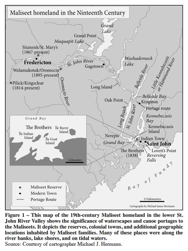 Display large image of Figure 1
29 In September 1798 Maliseet Louis Joseph, nicknamed “Big Louis,” started a farm on the north side of Grand Lake, where he cultivated “about three acres of a tract reserved for public uses.” He approached Surveyor General George Sproule asking for a grant of two parcels of land totalling 25 acres that included a harbour in which his “schooner boat” could carry coal for the province. Sproule reported the coal contractor supported Louis Joseph’s grant and knew him “as a sober honest industrious man,” and that the land was “of little value.”72 Since his youth, Joseph had accumulated intimate knowledge of the river and lake system through first-hand experiences in a birchbark canoe. Now he used his expertise to pilot the vessel carrying coal to market. In the following year, the Executive Council’s land committee approved Joseph’s land grant “of two points of Land containing about 25 acres on which he has made Improvements on the north side of Grand Lake.”73 But success in obtaining land title did not always secure land ownership through time. By July 1821, Louis Joseph, who was “about sixty-two years” old, petitioned Lieutenant Governor George Stracey Smyth to assert his rights to the farm. He explained that “for the last 23 years,” he resided “at Little Key Hole now the Grand Point,” a small peninsula on the north shore of Grand Lake, located north of present-day Gagetown (see Figure 1 – map). Joseph “sat down” on this land to “cultivate the ground” that provided “subsistence for himself and [his] Family.” After having lived on the land for more that 20 years, during which time he built a small house for his family, cleared the land that was “in a Wilderness State,” and cultivated about 20 acres, adjacent farmers wanted his land. “Improvements” or visual indications of colonists’ labour, including a fence, barn, or house, often indicated land ownership – unless one was Maliseet. Although provincial officials informed Joseph that the land belonged to the king, in 1818 General John Coffin told Louis Joseph that he could stay on the land “as long as he pleased.” However, Joseph explained, “since then and only a few months ago he was told by the people that he must not stay there any more for the land was not his, and they were going to put the Church where his House stood. And your Petitioner left it six weeks ago and now stays at the [French] Village [or Kingsclear] above Fredericton.” Although the petition writer recorded Louis Joseph as “a loyal subject of King George” who wanted a church in the vicinity, Joseph was “very sorry to have his House and cleared land taken from him.” He did not know how he would obtain a living, especially since he was “growing old and [physically] unable to clear more” land. Since “his good King” had encouraged his people to clear and settle the land, Joseph “did not know he was trespassing or doing wrong” and pleaded to the lieutenant governor “to look into his case” and “do something to help him.” Attorney General Thomas Wetmore, aboard a steamboat on the St. John River, wrote on the petition that he knew Big Louis very well, thought highly of him, and “supposed” that Joseph purchased the land because he “was formerly employed in navigating a vessel between the Lake and St. John,” forming Wetmore’s view of Joseph earning “a comfortable living.” Another provincial official who also wrote on the petition described Louis Joseph’s land as “part of a Public Reserve,” stating that the petitioner received an eight-acre grant in May 1799. The next year the council granted Louis Joseph a license of occupation throughout his life and, in 1827 and 1828, he received provisions and supplies at Grand Lake.74 New Brunswick’s recognition of individual Maliseet land was weak and at best temporary. While some licenses of occupations later became reserves, often at a reduced size, the informal acknowledgement of land use was not a grant and could potentially become invalid with the changing dynamics of settler communities and government administrations.75 Moreover, once Joseph passed on, the land would fall out of Aboriginal ownership. The threat of dispossession prompted Maliseet individuals and leaders to petition the province to assert their rights, but the colonial state addressed this matter in a sporadic and usually piecemeal fashion that facilitated – as opposed to arresting – the process of dispossession.
 Display large image of Figure 2
30 Close proximity to non-Aboriginal settlements made some Maliseets susceptible to diseases, and their struggle with their health reveals the additional places that families lived. In 1834, Reverend Michael McSweeney petitioned New Brunswick for remuneration “for Superintending the Spiritual concerns” of the Maliseets. Although primarily stationed at Kingsclear above Fredericton, outbreaks of “sickness” caused him to travel to small encampments, including visiting families at Nerepis who probably lived at the river mouth of that name which flows into the St. John River.76 By 1835 the missionary petitioned the province again for the same reason, but added the Maliseet community at Oromocto (located along the St. John River between Fredericton and Gagetown).77 The Maliseets, similar to their ancestors before them, often selected villages or campsites at the river mouths on the St. John River, places that were at the intersections of their homeland that provided access to numerous hunting and fishing grounds.
31 In 1838, as New Brunswick compiled the first comprehensive list of Aboriginal reserves in the province, officials considered a Maliseet reserve in the lower St. John River Valley.78 One of the six proposed locations was a 200-acre lot at Coal Creek, a tributary that flows into the eastern end of Grand Lake in Queens County. Other possibilities included 200 acres on the north side of Salmon River near Long Island, situated in the St. John River, in Queens County; a 100-acre site along the north shore of Washademoak Lake, downriver from Grand Lake, reserved “for Public uses”; a different 100-acre site along Eel River “at its junction with the Portage road,” possibly near Kingston where Maliseets portaged between Belleisle Bay and Kennebecasis Bay; and a 30-acre island between Kennebecasis Bay and Grand Bay in the St. John River and Grenadiers Cap, which included a four-acre island on the east side of Kennebecasis Island that was connected to Kennebecasis Island at low tide.79 All six proposed locations had water access and many of them had probably been – or, still were – former Maliseet campsites.
32 Later that year, Indian Commissioner Moses H. Perley visited Maliseet families encamped on three islands in the Kennebecasis Bay, totaling 15 acres, known as “The Brothers”: Indian Island, Goat Island, and Burnt Island. Located east of the Saint John River, The Brothers were near the entrance of Kennebecasis Bay, east of Boars Head, and south of Kennebecasis Island (see Figure 1 – map). Perley’s visit resulted in his recommendation that the Maliseets receive a license of occupation for these three islands, which Perley numbered one to three from left to right. Island “No. 1,” or Indian Island, which consisted of six acres unfit for cultivation, contained the Maliseet encampment, a camping ground that suited “them very well” and caused them to “wish by all means to retain possession of it.” Island “No. 2,” or Goat Island, which contained less than two acres, was “a small rocky Islet connected with No. 1 by” an intertidal land, “now nearly dry.” One-half mile to the east of island “No. 2” was island “No. 3,” or Burnt Island, consisting of seven acres, where the families expressed “a great desire to clear and plant it next year.” A “Mr. Simonds” claimed island “No. 3,” but when Perley approached to inform him that he planned to apply for the island on behalf of the Maliseets, Simonds surprisingly “waive[d] all claim in their favor & recommend[ed] that they settle there.” Perley wrote that Maliseet occupation of these three islands “would form an abiding place and a home for these wanderers where they would neither trespass or be trespassed upon by settlers.” Such a “comfortable” place for them would also “give less trouble to the public.”80 By April 1840, Perley found there were “nineteen families, comprising eighty-eight souls in this neighborhood” of Saint John.81 This Maliseet foothold in Saint John County was significant because it not only provided direct access to the market in Saint John but, equally important, to the Bay of Fundy, which offered a rich fishery as well as, for Louis Paul and his family, marine mammals such as seals and harbor porpoises in Kennebecasis Bay. American anthropologists Frank G. Speck and Wendell S. Hadlock learned from their Maliseet informants that individual families possessed kin ties to specific areas within their homeland called hunting territories that may have required an acknowledgment to the family by outside hunters who used the area. Colonization certainly created additional pressures over resources, causing the Maliseets to modify the boundaries of their family hunting territories probably by increasing their size for greater productivity. In the 1870s, the Paul family hunting territory was at the mouth of the St. John River. For the four Paul families and their extended kin at The Brothers, the islands helped retain access to their traditional family hunting territory on saltwater.82
33 A year later a census showed that Maliseet families were dispersed along the lower St. John River. On New Year’s Day in 1841, Indian commissioners Thomas C. Lee and William Tyng Peters estimated there were 201 Maliseets living south of Fredericton, including 90 people at Maugerville, across the river from Oromocto; 45 at Long Island, probably the Long Island located in Queens County; 32 at Kennebecasis; and 34 at Hammond River, adjacent to Kingston.83 This family distribution was more reminiscent of life in small family groups practicing seasonal mobility rather than disappearance.84
34 Moses Perley’s June 1841 account of his visit to two Maliseet camps in Saint John County revealed that maintaining cultural connections to the lower river valley was a challenge for most Maliseets. During his visit to The Brothers, probably Burnt Island, he mentioned dwellings and successful potato fields on one of the islands that totalled about five acres. Perley wrote: “I noticed several substantial slab camps at the Island and found two houses being erected, one of squared logs, the other a framed building with other indication of permanent settlement.”85 The other two islands, he described, were rocky, had a few trees that had been cut for firewood, but were “not at present occupied.” In November 1843 Perley reported to Provincial Secretary Alfred Reade that many of the Maliseets camped at The Brothers became ill, probably “from [their] low living, and exposure to the late wet weather.” He requested a medical doctor to attend to the sick and asked for £5 to cover these expenses.86 During the winter of 1846, Maliseet families in the vicinity of Saint John fell into “a very destitute situation.” Many of them suffered “from colds, fever and rheumatism” and required medical attention from Dr. Livingstone. Perley requested a £20 grant to assist the sick through this “trying period which must elapse until the Summer begins, and they can resume their usual occupations,” which probably meant fishing, hunting, growing crops, and selling their handmade items.87 Almost two years later, in October 1848, when the Maliseet population of Saint John County had decreased from 105 in 1841 to 51, Dr. John Paddock of Saint John visited the Maliseet homes on Indian Island where families were “reputed to be suffering from small pox.” The doctor reported that the disease outbreak caused many families to leave the island; this resulted in only about 25 people remaining there, including 3 infected adults who survived “without any particularly dangerous symptoms.” Dr. Paddock vaccinated 20 people, including the young and old, “in hopes the progress of the disease may be arrested.”88
35 The second of two Maliseet communities that Perley visited that was not on reserve land was testimony to family struggles at the mouth of the St. John River, the gateway to the Bay of Fundy. At Lovett’s Point, in west Saint John, across the river from Indian Town and probably near the Reversing Falls, Maliseet families “encamped on private property, and they pay to their proprietor a small sum for each wigwam they pitch there.”89 Eleven families, including the Gabriels, Mitchells, and Acquins, which totalled 48 people, probably participated in the local economy but entered into private contracts with landowners that involved payment for land use.90 In July 1842 a newspaper reported that a Maliseet elder named Molly Sescil, from the encampment across Indian Town, passed away “at the advanced age of 107 years.”91 The Maliseets at Lovett’s Point offer a prime example of the complexities of dispossession, specifically that lacking a land base was not a complete severance from places across their homeland. Maliseet families maintained cultural ties to their traditional homeland and camped at sites used by their ancestors long after dispossession occurred. As time passed, these local negotiations and intercultural relations created limited opportunities for Indigenous families where none seemed to exist.92
36 In Saint John County, some Maliseets found it increasingly difficult to depend on hunting and fishing for a livelihood. In 1841 Perley wrote that the most valuable animals – the moose and beaver – were nearly extinct in New Brunswick. Moreover, animal furs of smaller size and of lesser value had dropped in price. He believed that the Maliseet “ceased to regard hunting as a means of subsistence” and therefore increasingly turned to agriculture for survival.93 Perley observed: “The Melicetes have lately been exceedingly desirous of obtaining lands fit for cultivation on the River St. John, where they might erect substantial houses and have settled homes. In this desire I believe them to be sincere, as they are much annoyed at having so little ground they can call their own, and at being frequently warned off many of their old camping places as trespassers by the present proprietors.”94 Some Maliseet leaders petitioned to secure portions of their cultural homeland and families continued to camp and hunt on lands they no longer owned, strategies needed not only for survival but also to maintain a sense of homeland at a time when colonial officials and settlers exerted their claim to the lower St. John River Valley.
37 Maliseet families in the lower St. John River Valley also inhabited areas well outside Saint John County. In April 1849, at Maquapit Lake near the town of Sheffield, New Brunswick, Maliseet Joseph Francis, described as a “Local governor,” wrote Provincial Secretary John R. Partelow requesting urgent assistance for two elderly men: Nicholas Francis, who was 95 years old, and Christian Francis. Governor Francis, who may have been related to the two men, explained “the other Indians who have the care of them are unable to procure anything more than the bare necessities of life for themselves,” causing them to fall into “distressed circumstances.” He further supported his case by stating that the two elders needed help from the government because “a more proper object of charity cannot be found.”95 In February 1850, the Maliseet “Settlement” down river near Oak Point along the Long Reach, a small peninsula on the western shore in the civil parish of Greenwich and comprised of mostly women and children, was “utterly destitute and in a state of starvation.” Perley requested the overseers of the poor in Greenwich provide provisions to prevent starvation and sought immediate relief from the province.96
38 Despite hardships, the Maliseet returned to camping grounds on the coast. Census data shows a continual Maliseet presence with a changing demography in the lower St. John River Valley. In 1851, four Maliseet families – the Pauls, Atwins, Newells, and Francises – totalling 19 people, camped at Sheffield in Sunbury County. Downriver in Kings County, Maliseet families were dispersed along Kennebecasis Bay, including Joseph Paul, who worked as a cooper, and his wife Jane, in Hampton. In the town of Norton, the Lewis family, which consisted of Molly Lewis, a widow, and her young daughter and two sons, owned a small farm where they lived in a “log hut.” Further east, in the town of Sussex, lived a mother and daughter both named Mary Harvey.97 A decade later in 1861, 14 Aboriginal people in the town of Hampstead in Queens County, many of whom were identified as coopers and weavers, came from Cape Breton or peninsular Nova Scotia. To the west, in the town of Petersville, cooper James Lewis lived with his wife Mary, who was from Nova Scotia. The town of Hampton in Kings County had seven Maliseet residents and, in Norton, 18-year-old George Noel was a servant who worked as a labourer.98 By 1871, Maliseet demography in the lower river valley had changed again. In Kings County, 14 people lived in Norton, 29 individuals in Sussex, 4 in Studholm, and 26 people in Havelock. In Queens County, Maliseet families lived in dispersed camps in Petersville, Gagetown, and Chipman. In Sunbury County, Maliseet erected camps in Burton and Sheffield.99
39 Despite not obtaining a significant foothold below the head of tide at Fredericton, Maliseet families continued to live in their traditional homeland. In November 1881 Indian Agent William Fisher reported that a Maliseet family, “for two or three years past,” raised crops at Scotchtown, on Grand Lake, and near Maquapit Lake in Queens County. Poverty and immediate life requirements led some families to eat some of the seed distributed by the government.100 By 1882 nine Maliseets resided in Kingston in Kings County, nine others in Sunbury County, possibly at Oromocto, and forty-two Maliseets inhabited “Georgetown,” probably Gagetown in Queens County.101 In 1883 31 Maliseets in Saint John County lived in small family clusters along the lower St. John River, where the men traded furs ranging in an annual value from $75 in Kings County to $260 in Queens County.102 The continued Maliseet presence in Kingston led officials to report that there was a Maliseet reserve, although it was not apparently recognized by the government.103 As early as 1867 the Maliseets built their encampment near the railroad at “Apohaqui station” in Kings County, probably taking advantage of the promising market with the frequent arrival and departure of passengers.104 By 1887 and 1888, an “Apohaqui Band” of 10 families, or 52 people, some of whom were Mi’kmaq, lived near the woods in “log camps comfortably erected on the side hill overlooking Apohaqui station.” H.M. Campbell owned the land on which the Maliseets camped, permitting the families to live on the land while they produced handmade wares that included baskets, ax handles, and canoe paddles later “disposed of in the St. John market.”105
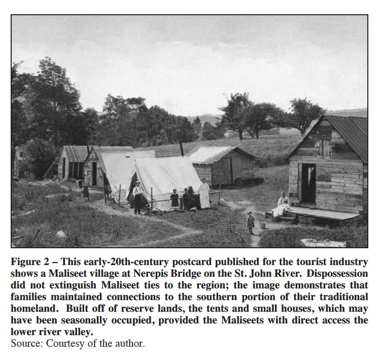
40 On 19 September 1838 the Maliseet received a license of occupation for The Brothers near Saint John; but provincial lists of First Nation reserves in the 19th century often omitted this community, making the status seem ambiguous.106 Upriver, families in the vicinity of the Oromocto River worked in the mills, fished, and sold handmade wares to adjacent farmers. Maliseet illness and probable tension with property owner W.H. Staten over natural resources led them to try a different approach.107 In 1892 11 men of the Atwin, Paul, and Sacobie families petitioned Ottawa, promising to “remove all shanties and buildings now erected on the lands of W. Statin” and to “avoid using the W. Statin land for camping or any other purpose” in return for other lands that could be purchased on George Nevers’s farm.108 Three years later Ottawa bought 125 acres from George Nevers, thereby creating the Oromocto Reserve (Welmooktuk), eleven miles downriver from Fredericton.109 In 1896 43 Maliseets lived on the reserve, where each family received a parcel of land that was 90 by 240 feet, leaving most of the reserve as wooded lands with only about 30 acres cleared for agriculture.110 The two reserves assisted Maliseet families in retaining ties to the lower St. John River Valley, which worked with other strategies – including paying rent and continued land use after dispossession – to maintain connections to a brackish riverine environment in their homeland.
41 Even by the early 20th century, New Brunswickers still questioned what constituted Aboriginal land along the lower St. John River. In 1905, Saint John lawyer A.O. Skinner tried to apply for a lease of Indian Island, part of The Brothers Reserve, near Milledgeville. After research, Secretary of the Department of Indian Affairs J.D. McLean replied that the Maliseets never surrendered their rights to Indian Island and, therefore, the department was “not in a position to consider the question of application for lease.”111 This, of course, was a different perspective than that offered by Moses Perley decades before who recommended that the Maliseets receive a license of occupation to The Brothers. Maliseet families, although mostly dispossessed of the lower river valley, still lived in the southern portion of their traditional homeland, where they engaged in cultural practices and participated in the local economy.
42 Also in the early 20th century, some New Brunswick residents recalled that Maliseet or Mi’kmaw families camped on the periphery of farmlands. John Hayes remembered stories that his father told him about Indigenous people who camped in a few places in the Bloomfield region, near the Kennebecasis River. In the summer, Mi’kmaw and Maliseet families harvested wood to make picnic tables and chairs that they sold to townspeople. Camping behind Bloomfield Station on the hills may have allowed them to live separate lives from the farming families, and these separate spaces also encompassed the river where they still paddled canoes to fish for eels or perch. Seasonal residence on farmland and the harvest of natural resources caused Hayes to reflect about Aboriginal people on his family’s land: “It’s kind of as if they had a right to do that.” Such tolerance may have been uncommon but Hayes asserted he “never heard” of any instance where neighbors evicted people from private property, especially since “they weren’t doing any damage” by harvesting only small trees to build furniture.112 Although economic opportunities for the Maliseets led to business transactions with local homesteads, Hayes’s important testimony suggests that these interactions were minimal – indicating some Indigenous people lived separately from New Brunswick society.
43 Throughout the 19th century Maliseet families continued to live in the lower St. John River Valley, where they encountered a growing Euro-Canadian population that increasingly were shaping the province for their own needs. To maintain a presence in the region, Maliseets returned to old camping grounds and some families created new ones for economic opportunities. As observed in the distant past, homelands often welcomed Indigenous peoples from adjacent communities joined together by kin ties; but the lower St. John River was still Maliseet territory. The changing demographic distribution was not only reminiscent of seasonal mobility, but the movement could potentially diminish the tension colonialism created. As individual Maliseets struggled to maintain their lands, they employed numerous strategies – and leaders secured two small reserves that served as a vivid reminder that property boundaries could also be utilized to create and protect Aboriginal lands. Equally important, it was the Maliseets’ ability to retain their expertise on the water, which included birchbark canoe technology and geographic knowledge, that contributed to their persistence in the southern portion of their traditional homeland. Movement on the water was not only essential to their survival, but it was key in sustaining connections to the region. Historical memory, as shown with Gabriel Acquin, highlights his people’s prowess and knowledge of the river that forged critical linkages to their past, challenged declension narratives, and shaped personal experiences.
44 In 1846, Louis Bear owned the only two-story home with a stone basement at Kingsclear; but along the river were 18 to 20 birchbark wigwams, indicating that many families still practiced seasonal movement while a few permanent structures helped to legitimize Maliseet rights to the reserve.113 However, a close examination of the inside of Bear’s house reveals that he built a birchbark wigwam on his living room floor, the only dwelling that truly evoked the feeling of home.114 Similar to Bear’s house, historians need to peek through the different types of doors to better understand Indigenous lives during the 19th century. Bear’s living arrangements remind us that for those Maliseets who adopted some components of Euro-Canadian life may not have fully departed from their cultural traditions, revealing the complexities of Maliseet experiences in a century of heightened dispossession. If historians do not explore the microcosms of Indigenous peoples’ lives, the risk of over-emphasizing the power of dispossession emerges as a real danger. Maliseets could temporarily avoid New Brunswick society and their water knowledge served as a tremendous advantage to them in their partially colonized homeland.115