"Wedded to the Marshes":
Salt Marshes and Socio-Economic Differentiation in Early Prince Edward Island
Matthew G. HatvanyUniversité Laval
1 FOR MANY YEARS CONSIDERABLE SCHOLARSHIP has focused on what Island historians call the "Land Question" – the political relations engendered by the proprietary system of landholding that dominated Prince Edward Island history between 1767 and 1875. Over the past two decades, however, much has been learned about the development of social and economic differentiation within the rural communities of 19th-century Atlantic Canada and Quebec.1 Prince Edward Island history has not generally benefited from this approach. The extent of social and economic differentiation among the Island’s squatters, tenant and freehold farmers remains relatively unknown, and issues of rural social and economic development have also received limited attention. As a result, most Island historiography continues to imply that rural society was a roughly egalitarian community of tenant families.2
2 Certainly the development of freehold tenure on the Island was hindered by a number of proprietors who refused to sell land at reasonable prices, if they agreed to sell at all. Nevertheless, significant numbers of freehold landowners did emerge from the ranks of the tenantry, and by 1833 they numbered one-third (32.8 per cent) of the Island’s landholders and possessed 41 per cent of the occupied land area. The manner in which this process took place has not been addressed, but if the testimony given before the land commissions of 1860 and 1875 is reliable, the explanation for the development of social and economic differentiation among rural families is relatively straightforward. Those families who were fortunate enough to raise themselves above the ranks of the tenantry had been able to accumulate the necessary capital – as a result of favourable social and economic variables – to purchase the title to their property.3
3 This study turns to an analysis of one of those variables, salt marsh hay, in order to better understand how access to a limited natural resource acted as a factor influencing social and economic differentiation within the Island’s proprietary system. The available evidence indicates that access to salt marshes, especially in the earliest decades of British settlement, played an immensely important developmental role in the island’s rural society and economy. Salt marsh hay was an indispensable agricultural commodity in the early settlement period that determined land prices and was a principal fodder for livestock, still harvested in the early 20th century.
4 From the coming of the Acadians in the 1720s until the mid-19th century, the salt marshes of the Island were ranked as equal to or surpassing the cleared uplands in value. Physical and legal battles over control of the marshes spilled over into the courts and legislative assembly. Marshes were sold, rented and traded, and specific values were recorded in terms of the stacks of salt hay produced. During the early settlement period, when the colony was still covered by a thick virgin forest, the salt marshes – extensive grass-like prairies – were most highly valued. They were a welcoming vista to European immigrants who were unfamiliar with great forests, accustomed to open spaces and in need of pasture to feed their livestock. The importance of the salt marshes to the tenantry can be appreciated in reading the comments of Lord Selkirk, who wrote in 1803 that "the country, in its natural state, is entirely covered with timber; with the exception only of the salt marshes".4
5 Despite the Island’s relatively small size, its scattered coastal and estuarine marshes are significant and equal approximately one-sixth the size of the much better known salt marshes diked and exploited by the Acadians of Nova Scotia. In Lord Selkirk’s time there were between 5,000 and 10,000 acres of salt marshes and sand dunes supporting natural grasses on the Island’s coastline (Figure One).5 Early colonists recognized these areas as a rich and diverse environment, abundant in wildlife and marsh and dune grasses. Contemporary research confirms this colonial perspective. Salt marshes, and the thousands of tons of decayed plant detritus produced annually in them, are highly fertile environments with a productive capacity surpassing that of much of the best farmlands in the world. They also act as nurseries and feeding areas for large stocks of fish and waterfowl.6
6 European exploitation of the Island’s tidal marshes began with the coming of the Acadians, and by 1751 it was noted that most Acadian villages on the Island were "located along . . . [marsh] meadows, the inhabitants preferring these areas . . . because it would cost them hardship and labour to clear [upland] fields". The Island census of 1752 specifically mentions the Acadian exploitation of the marshes for pasture and livestock fodder. Contrary to popular belief, the Acadian reliance on the salt marshes was not unique in North America; other European settlements in early New France, New England and the mid-Atlantic colonies of New Jersey and Delaware developed similar patterns of significant reliance on salt marsh exploitation. It is not surprising, then, that following the expulsion of the Acadians from Prince Edward Island in 1758, British settlers began colonizing similar areas of the Island. By 1798, as the first extensive British census of the Island reveals, settlement patterns concentrated along the bays, shores and river estuaries where transportation was best facilitated, and where salt marsh grass thrived.7
Figure One : Lots and Marshes on Prince Edward Island
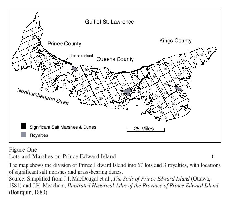
Display large image of Figure 1
7 Contemporary accounts indicate that the salt marshes were especially prized for the ease by which geese, ducks and other waterfowl could be obtained there. Eels, shrimp, smelt, herring, alewives, flounder, lobsters, mussels, oysters and other fish were like a "manna from heaven" that could be scooped up in nets by the bushel. This natural bounty was, as one commentator wrote in 1819, "of great assistance to the inhabitants, and in particular new settlers, before they have time to raise food from the produce of the land".8 Before the timbered landscape could be cleared and sown with grass, settlers also found that the natural grasses of the Island’s salt marshes readily furnished abundant pasture and fodder for livestock and draft animals. Spartina alterniflora and Spartina patens were the two chief marsh grasses used by the farmers, and while they are about 14 per cent less nutritious than upland hay, it was widely reported that an acre of marsh, supplying an average of one ton of salt hay, was sufficient to support a cow through the winter.9
8 One of the first British settlements on the Island was established in the early 1770s on the north coast of Lot 34, at Stanhope Farm. The colonists there found the process of forest-clearing slow and arduous, and they quickly turned to harvesting the salt grass in the marshes and dunes along the north shore of the lot. During the first eight years of settlement at Stanhope Farm about 25 tons of marsh hay were harvested annually.10 This pattern was repeated by other colonists coming to the Island, and by 1805 roughly 4,300 acres of salt marsh were actively being exploited for pasture and fodder – that is to say, roughly one acre of marsh hay per capita for the Island’s 4,400 inhabitants.11
9 Active proprietors were keenly aware of the importance of the salt marshes to the early colonists, as was clearly seen in the settlement patterns of Lord Selkirk’s estate around Point Prim (Lots 57 and 58) in 1803. One of Selkirk’s first tasks in preparing the estate for settlement was to survey and divide the salt marshes for distribution to the colonists. Selkirk originally wanted to establish nucleated villages on the estate, but the settlers persuaded him to concede long and narrow 50- and 100-acre farm lots that would allow all to have frontage on the salt marshes. Each 100-acre farm on the coast received one acre of marsh. Selkirk set his land prices for those who wished to purchase land at half a dollar per acre for backlands, one dollar for frontlands and five dollars for marsh and cleared lands. He also set aside portions of marshland for late-comers who would settle inland. For Selkirk, marshlands were among the most valued lands on the estate.12
10 Selkirk likened the economic factors linking early Island agriculture to salt marsh exploitation to the intimate relations shared by husbands and wives when he wrote that the settlers were "wedded to the Marshes": "Marsh is extremely run upon by all the inhabitants" and "1 acre is as much value as 5 or perhaps 10 of woodland. . . . Indeed it is spoken of as an extraordinary circumstance that an Englishman has settled on a lot . . . without any marsh hay". In the earliest period of settlement, colonists such as those at Stanhope Farm and Point Prim gained access to the salt hay by paying rent or fees to the proprietors on whose estates the salt marsh existed. In addition, it appears that they also gratuitously helped themselves to the marshes on unsettled estates that were not overseen with vigilance.13
11 Asserting control over the marshes was a problem for some proprietors, as is clearly seen in the situation facing the native Mi’kmaq population. The Mi’kmaq had been completely alienated from the land during the division of the Island into lots in 1767, and by the early 19th century this small group was barely subsisting on Lennox Island, a small islet in northwest Prince Edward Island. The economic situation of the Mi’kmaq was marginal because of their lack of legal title to the land, although their presence on Lennox Island was to a large degree tolerated by the island’s owner and a perplexed colonial government which had no alternative solutions. In the early 19th century the Mi’kmaq sent petitions to the governor complaining that the marshes surrounding Lennox Island (which produced about 60 tons of salt hay per annum) were under constant infringement by settlers from the surrounding region, some of whom had indeed obtained the right to harvest the marshes from Lennox Island’s absentee proprietor. The soil on Lennox Island was infertile, the Mi’kmaq complained, and thus they depended in large degree on the salt marshes to feed their livestock. No legal intervention was forthcoming, and the Mi’kmaq were forced to physically deter colonists from harvesting the salt hay there.14
12 As the problem faced by the Mi’kmaq indicated, control of valuable salt marshes was at times a "contested terrain". Stuart Moore shows in A History of the Foreshore that in the 19th-century British Empire the right of ownership of intertidal areas was often unclear. Debates raged between nominal owners of these lands (often the Crown) and those claiming ownership through long and often undisturbed use (proprietors, fishers and farmers).15 Such a situation existed in Prince Edward Island, where the Crown possessed nominal ownership of most salt marshes through the Fishery Reserves, "a belt 500 feet in width, round the shores" of the entire colony. This land had been retained by the Crown to promote a sedentary fishery, but the existence of these reserves was ignored by proprietors, who asserted control over the marshes adjacent to their estates by surveying, renting and selling them.16
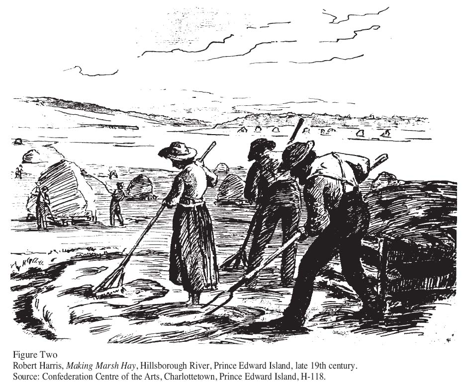
Figure Two : Robert Harris, Making Marsh Hay, Hillsborough River, Prince Edward Island, late 19th century.
Display large image of Figure 2
13 As Rusty Bittermann writes of the fishery reserves, the use and control of this coastal land was of no small significance to fishers and farmers alike. In 1837-38 ownership of this land became the focal point of a colony-wide struggle as tenants challenged the right of proprietors to control and charge rent for this land. It was a heated dispute, for as one champion of the tenantry pointed out, the first 500 feet of shoreline amounted to almost eight acres of land for the average coastal farm. For the entire colony, then, this contested terrain accounted for some 20,000 acres "of the most productive soil" under cultivation or sand hill grass from which the tenants derive "their chief support". From the point of view of the tenantry, a satisfactory resolution of this dispute was never achieved as the Colonial Office decided not to disrupt the status quo of nearly half a century of private control over the coasts, thus leaving the reserves in the hands of the proprietors and freeholders of this land.17
14 Control over the salt marshes was important because it meant access to the salt hay growing there. As every northern farmer knew, no other crop was as vital as hay, and if valued at its market price, it was the "king of all crops". "For the sake of supporting stocks of cattle", one Island resident wrote in 1804, "hay is in constant demand . . . and commands everything". Hay fed the livestock which were a key export, and it nourished the draft animals used in plowing, harrowing and hauling. It is no understatement, then, that hay production was the key to the island’s agricultural economy at this time.18
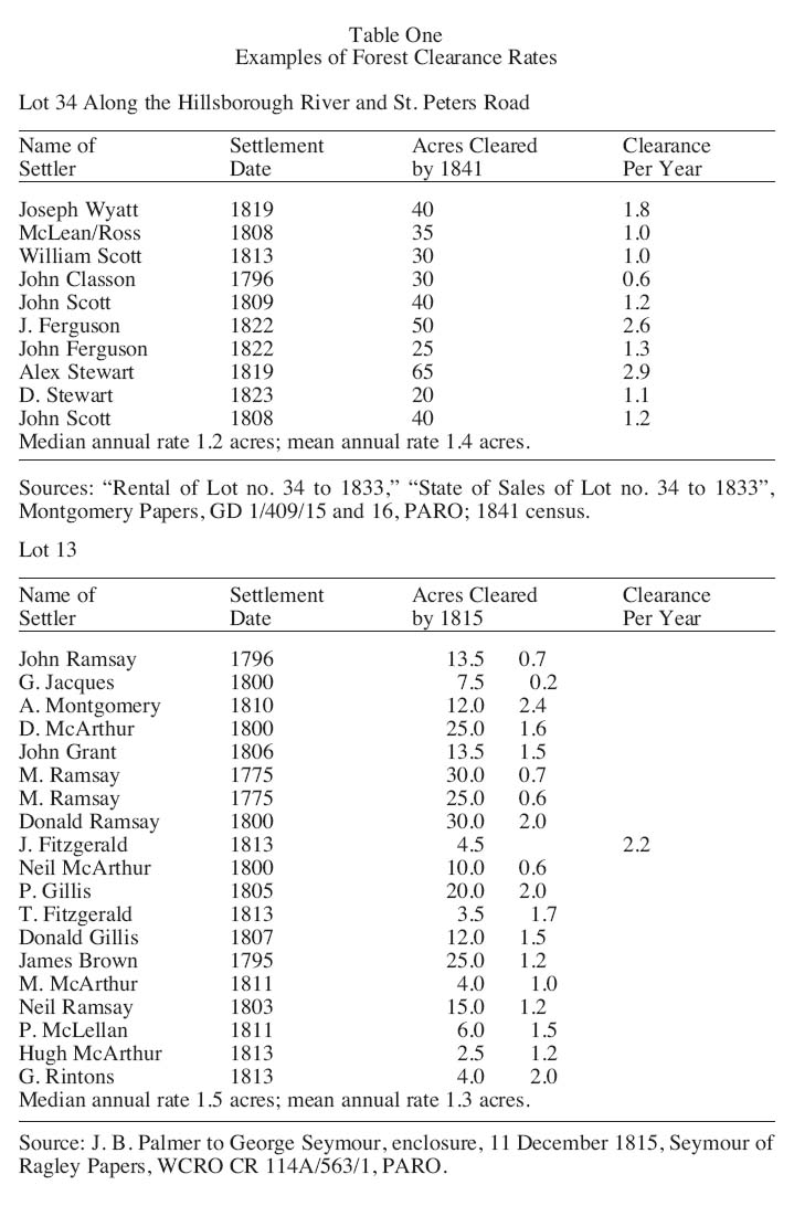
15 From the first Acadian settlements until the decade of the 1820s, the salt marshes were far more important than the uplands in supplying much-needed hay. Marsh hay was used as pasture and harvested as fodder; it was sold in the domestic market places; and it was shipped throughout the Gulf of St. Lawrence to the logging centres of New Brunswick and Nova Scotia and the fishing ports of Newfoundland.19 Lord Selkirk perceived the strong correlation between hay production and the economy when he wrote that raising livestock was more important than tillage and that most cash earned by the settlers came from the export of cattle to Newfoundland.20 The census of 1805 reveals that almost 50 per cent of all arable land in the colony was devoted to hay production to feed livestock, of which 64 per cent was marsh-produced. The total market value of the hay harvest was estimated at more than £13,000 – greater than the combined market value of all other field crops except potatoes. If the value of the hay-nourished livestock (worth an additional £15,441) is calculated into the assessment, the significance of the marsh and upland hay increases dramatically.21
16 As the basis of the early farm economy, livestock was utilized for food, draft power and as an easily marketable commodity. Throughout the first half of the 19th century, horses sold at prices from £5 to £25, cattle and oxen at £5 to £9 and sheep at roughly £1 per head. When the average annual rent for a 100-acre farm was £5, the sale of a single cow might meet this expense, while the marketing of a few animals could furnish necessary cash or credit. As a means of feeding such valuable livestock, early commentators stressed the importance of salt hay to the well-being of the Island farm family. A letter from 1819 stated that the Island’s "marshes . . . produce a high strong grass . . . which makes excellent hay, and is of great use to new settlers to feed their cattle during the winter, before they can clear sufficient land to produce . . . upland grass".22
17 Before expensive fences and stockyards could be built, the cattle and sheep of coastal farmers were often pastured on the marshes. In the later part of July, "We commence hay-making", one commentator wrote in 1836, "and will require a month to make our marsh and upland hay". To take their scythes out on the marsh, the farmers chose periods of neap tides in July and August when the water remained low. After the marsh grass was cut and allowed to dry in the sun, the salt hay on the lower marsh was gathered by rake and pitchfork and brought to the higher marsh where it could be placed on a sedge and hauled to upland storage by oxen. If it was too difficult to get draft animals on the marsh, posts (which can yet be seen today) were driven into the marsh to create a platform (staddle) which could support the salt hay above the tides. There the salt hay was covered with a layer of thatch and left until the marsh froze and it could be retrieved with the aid of draft animals (Figure Two).23
18 Access to the naturally occurring salt hay was a blessing to the early settlers because it required little capital or labour requirements. It needed to be neither cleared, ploughed, seeded nor cultivated. It was a highly reliable crop that grew profusely even in dry summers, and it could be harvested late into the fall. Unless a marsh was diked or ditched for more intensive agricultural purposes, the only substantial mental, capital or labour inputs involved in exploiting this resource occurred at harvest time. This circumstance allowed farmers with access to the marshes to raise livestock for food and rental payments, while freeing additional time for other income-enhancing pursuits.
19 There was a clear distinction between early and later settlement in respect to the level of access to the salt marshes. By the 1830s most coastal land was claimed, denying to settlers after this date the benefit of salt hay to feed their livestock while beginning the farm-clearance process. A commentator wrote in 1850 that for newly arriving settlers without sufficient hay, "The expense of supplying fodder for the seven dreary months of winter bears heavily . . . and in countless instances cattle are actually destroyed in preference to keeping them. The result is, that the[se] people . . . are decidedly the poorest".24 This observation suggests that as availability of the salt marshes became limited after 1830, access to the marshes became a source of social and economic differentiation between those who could exploit the salt hay there and those who could not. As early as 1804 John MacDonald noted that "There appears to me to be a difference of twenty years in the progress of lands having marsh, and those which have none: consequently a proportionate difference in expense and profits".25 In MacDonald’s opinion access to the salt marshes and sand dunes was a significant factor shaping social and economic differentiation. This factor would become especially poignant in distinguishing the early settlers from the largest waves of immigration coming to the Island between the late 1820s and the 1840s.26
20 Unlike the earlier British settlers who came to the region with some capital, immigrants from the late 1820s to the 1850s often arrived with little money.27 Governor Henry Vere Huntley wrote in 1842 that these later immigrants arrived on the Island "without one farthing in their hands", and in attempting to settle a forested backland without capital, they readily fell into arrears of rent.28 Supporting Huntley’s observation, a letter from the same period written by an immigrant to his brother in Ireland indicates the declining access to coastal frontlands that was occurring during the decade of the 1830s: "Brother . . . the reason I can’t encourage you . . . to come here is, the [coastal] land to be got here is taken up by the old settlers. If a man got two or three hundred pounds he could purchase [frontlands] . . . you can get [rent] 100 acres of woodland [backlands] for five pounds but there could be no gains by it for five years [until part is cleared]".29
21 Until a farm could be cleared, little hay could be raised to support livestock and draft animals. Yet the clearing of heavily forested land was no easy task. An analysis of forest clearance rates in two communities on Lot 34 and Lot 18 indicates that families cleared a median average of only one-and-a-half acres of forest per year, about average for other areas studied in early Canada (Table One).30 At this rate, as commentators noted, most settlers did not "clear more than 20 or 30 acres all their life". And once cleared, the land was still of little immediate use: "If a farm is cleared of the hardwoods . . . the stumps cannot be taken out of the ground, unless at very great expense, until they decay, which will be eight, nine, or ten years – and in all that time scarcely any ploughing can be performed; in course but little [hay] will be produced".31
Table One : Examples of Forest Clearance Rates
Display large image of Table 1
22 For those later immigrant families settling away from the marshes, the attempt to raise livestock and feed draft animals was more difficult as a result of the lack of immediate hay or pasture. This dilemma is seen in the agricultural census data, which demonstrates that as settlement of the interior progressed through the first two-thirds of the 19th century, the mean average of hay available per animal decreased (Table Two). This imbalance lasted until the 1870s, when most settlement communities reached maturity and greater yields of hay were produced. John MacDonald was keenly aware of this developing dichotomy early in the 19th century, when he wrote that it was "those who settle in the woods, so as not to have quantities of hay to their wishes, [who] will do anything to procure hay".32
23 Without adequate pasturage farmers released livestock into the forest to forage. This practice was inefficient yet possible during the summer months. Nevertheless, adequate fodder and shelter were essential to surviving the long winters and late springs of the Island.33 John Stewart wrote in the early 1800s that "the greater part of the cattle are supported during the winter . . . by salt marshes, producing annually large crops of strong nutritive grass, without trouble or cultivation, which makes excellent hay."34 For those without adequate fodder, and without access to salt marshes at the onset of winter, an 1844 Island almanac stressed diligence in avoiding "an overstock for winter – one half the animals well kept, will yield more profit, than the whole half kept". Yet the difficulties poorer farmers faced in complying with this advice are apparent, as when Walter Johnstone noted in the 1820s: "From the poor way in which their cattle are fed during the winter, some of them die of weakness. . . . New settlers, unless they get marsh hay along with their farms at first, get slowly on in keeping stock".35
Table Two : Hay Yields Per Animal, 1805-1871
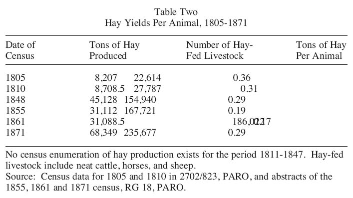
Display large image of Table 2
24 By the mid-1830s, visitors to the Island were commenting on the productive differences, especially in the quality and quantity of livestock, between coastal and inland farms. While travelling inland from Charlottetown to Bedeque in 1837, Nathaniel Carrington noted: "I have not seen an animal fat enough for beef and their horses are miserably poor animals which I conclude to be from the quantity of hay produced". Without adequate fodder, interior farmers consistently received lower market values for underweight animals. In addition, because these farmers could not feed all of their livestock through the winter, they slaughtered their animals in the fall, often glutting the market and lowering prices. Better-off farmers with adequate fodder reserves sold in the spring, when market demand increased and livestock prices reached a peak.36
25 While the fall slaughtering of mature livestock decreased the reliance on winter fodder, it did not obviate the need for adequate supplies to see immature animals through at least two years before maturity. For those farmers without ample reserves, winter was a desperate time. David Ross, a coastal farmer from the southern portion of Lot 34, often noted in his diary the despondency of his poorer backland neighbours following the winter season. In the spring of 1849 Island farmers had to deal with the long-term effects of the potato blight that had recently struck. Ross also wrote that, as a result of a prolonged cool spring, "Only a few have fodder for their cattle [and] those that have [a surplus] to sell do so at exorbitant prices".37
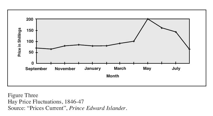
Figure Three : Hay Price Fluctuations, 1846-47
Display large image of Figure 3
26 A few years earlier, in the exceptionally cool spring of 1847, scarcity of fodder drove hay prices almost 300 per cent above the fall market rate, and Ross himself ran out of fodder. He was forced to purchase hay, but had enough capital in reserve to afford the inflated prices (Figure Three). Ross was more fortunate than his poorer neighbours whose cattle, he noted, were starving to death because they could not afford the high prices for hay. Significant hay price fluctuation in the late winter and spring was common, and for middling and better-off frontland farmers such as Ross, auxiliary supplies of marsh hay and capital in reserve at the beginning of a long and cold spring often meant the difference between the survival and destruction of their livestock.38
27 Because hay grew throughout the year, no other crop was more vulnerable to changes in the weather. In winter, grass roots were susceptible to frost damage without adequate snow covering; in spring, rain and moderate temperatures were needed to begin the growth process; in summer, dry weather or too much rain could damage harvest yields; and in late summer, dry weather was needed to reap, cure and store hay. Early sources are filled with instances when the vagaries of climate caused damage or prevented the growth of grass, as when David Ross lamented the loss of his salt hay left stacked behind the small dikes on his marsh: "A heavy gale . . . drove in all our sea . . . gates, [and washed away the] marsh hay. . . . Always some disaster befalls everyone – it would not be P.E. Island else". Invariably, when disaster struck, the ubiquitous notation found within contemporary sources recorded a corresponding hardship for marginal families. For the better-off, such adversity often constituted only a brief reverse.39
28 In 1810 4,390 tons of salt hay were harvested, equaling almost two-thirds of the total hay produced that year. Following 1810, marsh hay was never again enumerated in the Island’s agricultural censuses, making it difficult to know how reliance on this resource changed over time. Fifty years later, in 1860, hay continued to be the predominant crop, but salt hay as a percentage of the total hay harvest had decreased markedly to an estimated 14 per cent.40 After the mid-19th century, cropping the salt marshes became less important, and the final harvests came in the early 20th century. The eclipse of salt hay in favour of upland hay was a result of the finite amount of salt marsh available, as well as the mounting cleared acreage available on coastal and inland farms and the desire to utilize more nutritious upland hay as animal husbandry modernized. Additionally, beginning in the 1840s upland fields became more attractive with the appearance of labour-saving horse-drawn reapers and rakes that were often difficult to use efficiently on the soggy marsh terrain.41
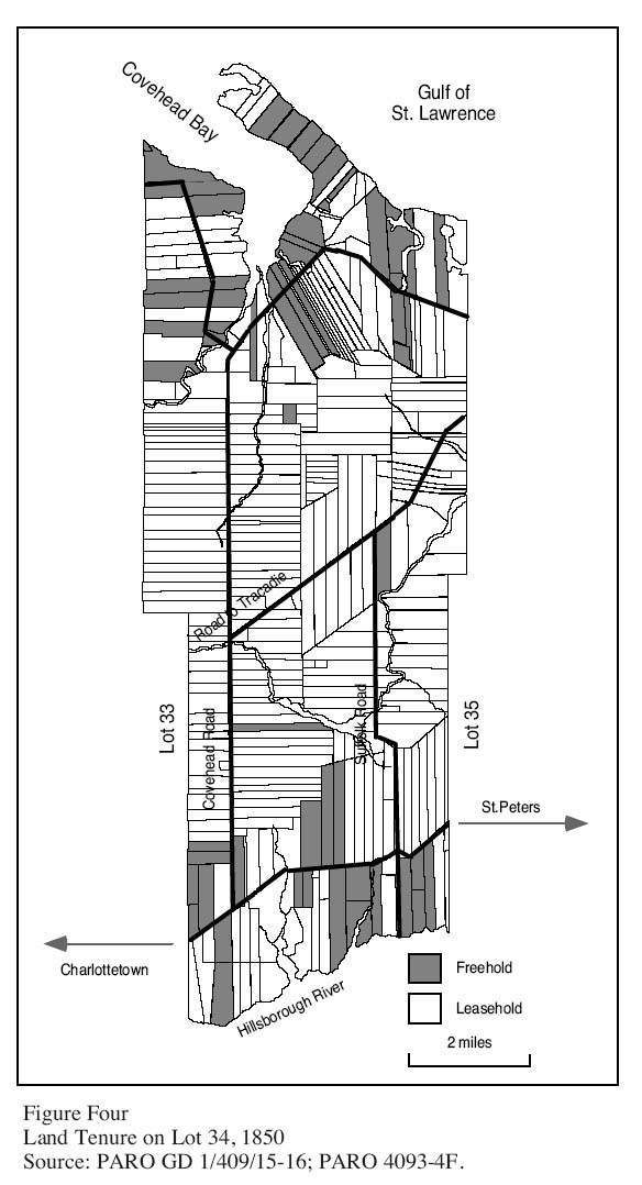
Figure Four : Land Tenure on Lot 34, 1850
Display large image of Figure 4
29 For the first half of the 1800s a multitude of laudatory comments regarding the blessings of salt hay exist in the historical documents. The later declining importance of salt hay to the agricultural economy is reflected in the absence of such comments in the written records of the second half of the 19th century. As the forest was cleared and the agricultural landscape matured, and new means of exploiting the marshes and estuaries for other resources were discovered, salt hay appeared less important. It was eclipsed in the popular consciousness as a factor of social and economic differentiation by the "new-found" benefits of mussel mud found in the Island’s marshes and estuaries. While soil conditions and fertility differed across the colony, almost all arable land on the Island suffered from an acidic PH. Since the colony lacked limestone deposits – the usual resource used to adjust PH imbalances – early Islanders began mining the tidal marshes and flats that contained a calcium-rich mud laden with oyster and mussel shells. As early as 1822 Walter Johnstone wrote that this "mussel mud", when applied to the fields, "brings the best crops . . . [and] is of great advantage".42
30 Mining this highly fertile mud was difficult and expensive until the 1860s, when mechanical machines were invented to replace the time and labour-intensive process of hand digging. David Weale writes that as a form of fertilizer the application of mussel mud increased crop yields dramatically – especially hay – and it was in great demand on Island farms until the mid-20th century. In 1875 when the proprietary system was abandoned, a land commission was assembled to determine the value of lands to be sold to former tenants. As the findings of the commission revealed, tidal marshes and estuaries were still one of the most important elements influencing agricultural productivity on the Island, but now as a vital source of "mud" fertilizer. The land commission’s report made no references to salt hay, but it was replete with evidence concerning the differential value and prosperity of coastal land in comparison with interior lands based on access and distance to mussel mud sources.43
31 Salt marsh hay played a significant role in the early stages of the Island’s settlement and development. Exactly how significant this factor was is difficult to ascertain because of the lack of census data after 1810. Certainly access to the salt marshes was important in creating social and economic differentiation between coastal and inland farmers. This is readily apparent, for example, in such documents as the cadastral map of Lot 34 at the middle of the 19th century. This estate map shows that a substantial number of freehold lots were grouped primarily along the river and gulf coasts while leasehold tenure dominated the interior (Figure Four).44 However, access to the salt marshes alone cannot fully explain why by the 1850s freehold tenure existed primarily along the coasts of places such as Lot 34. It does suggest, however, that the coastal farmers shared in common a combination of favourable factors such as the amount of capital they arrived with, an early settlement date, good connections to markets by water and access to limited resources such as salt hay and, later, mussel mud. All of these played a part in shaping the patterns of social and economic development on the Island in the 19th century.
32 Ultimately, the importance of salt marshes in the recounting of the Island’s past lies not in their substantial intrinsic value but in underlining the importance of a more geographically-informed approach to the developmental patterns that emerged early in the Island’s colonial history. A geographical approach to understanding settlement and development patterns in the Island’s early history demonstrates not a relatively undifferentiated tenantry, as so often has been assumed, but rather signficant evidence of social and economic stratification within the ranks of the Island’s settlement families. In this respect, there is still much to be learned about the role of class differentiation in shaping the Land Question on Prince Edward Island.
Notes